Reclaiming the Principles of Common Consent, Parliamentary Tradition, and Local Governance
Welcome to the Assembly
Welcome to the foundational guide, legislative blueprint, and community hub for our upcoming civic reenactment. In an era increasingly defined by political gridlock, institutional centralized overreach, and a growing disconnect between the citizenry and the corridors of power, this exercise offers an intentional retreat into the mechanics of self-governance. We are bringing together passionate individuals to participate in a structured, immersive environment designed to mimic the foundational legislative mechanics that forged the American Republic.
Borrowing the highly participatory architecture of the historic Utah Caucus system and merging it with the formal solemnity of the early Continental Congresses, this simulation invites participants to step out of the audience of modern political theater and onto the stage of actual legislative deliberation. Our primary vehicle for interaction is the parliamentary process, driven by the principles of common consent and direct democracy. Here, you will not simply debate abstract concepts; you will organize into distinct caucus blocks, draft resolutions, debate amendments under strict parliamentary rules, and work toward actionable, legal mechanisms that can be executed in the real world.
“Real liberty is neither found in despotism, nor in the extremes of democracy, but in moderate governments.” — Alexander Hamilton. This simulation aims to rediscover that moderate, robust balance through rigorous structural debate.
This initiative is engineered specifically for those who believe that our current political institutions are failing to adequately address systemic existential crises. Whether your primary concern is economic stability, technological overreach, or moral preservation, this assembly provides a laboratory to test solutions. By dividing our assembly into small, cohesive caucuses, every voice is granted a direct channel to shape the overarching collective resolutions. Our goal is to conclude this event not with vague statements of intent, but with concrete, formatted legislative proposals, constitutional amendment templates, and a binding budget blueprint capable of driving authentic grassroots political action.
Historical Background & The Utah Model
To understand the design of this simulation, one must look to two foundational pillars of Western republicanism: the early Continental Congresses of 1774 and 1775, and the modern legacy of the Utah Caucus System. When the original Continental Congress convened in Philadelphia, it did so without a formal constitutional mandate. It was an emergency gathering of distinct, self-governing colonies seeking unified, legal, and defensive solutions to unprecedented overreach. Those early delegates relied heavily on parliamentary procedures inherited from the English system but adapted them to prioritize the principle of common consent—ensuring that small colonies were not utterly crushed by the larger ones, and that decisions carried genuine moral authority.
Centuries later, the state of Utah retained a unique echo of this decentralized, neighbor-to-neighbor governance through its traditional neighborhood caucus system. Unlike states that rely purely on direct primary voting, the caucus system requires citizens to gather physically in local school gyms, churches, and community centers. In these neighborhood meetings, citizens debate issues at a hyper-local level and elect trusted delegates from among their own neighbors to represent them at broader conventions. It is a system built on the premise that political power must bubble up from the grassroots, rather than trickle down from centralized party elites.
Our simulation synthesizes these models to correct the flaws of the contemporary political ecosystem. Modern digital discourse has fractured the civic bond; we substitute anonymous online echo chambers with face-to-face parliamentary negotiations. By simulating the Continental Congress through a structured caucus model, we challenge our delegates to find common ground without compromising on existential necessities. We operate under the assumption that the structural framework of the United States Constitution remains our greatest shield, but that the machinery of our current government requires structural restoration from the ground up, initiated by an organized and educated populace.
The Principles of Engagement
To ensure that our proceedings mirror the gravity of a true constitutional body, all sessions will strictly adhere to traditional parliamentary law, guided by a modified variant of Robert’s Rules of Order. This structural rigidity is not intended to stifle debate, but rather to protect it. Parliamentary procedure ensures that the majority rules, the minority is heard, and individual factions are prevented from hijacking the broader body’s time. Every motion, point of order, and amendment will be recorded by our clerk, ensuring an unbroken ledger of our legislative progress.
Common Consent: Decisions are pushed toward broad consensus, ensuring that actions carry the unified weight of the entire delegation rather than a bare, divisive majority.
Decentralized Caucus: Delegates are grouped into independent caucuses to deeply evaluate distinct issues before bringing proposals to the general floor.
Actionable Outputs: Every debate must directly tie to a tangible output: a constitutional amendment, a civic action item, or a targeted allocation of resources.
The core philosophy driving this assembly is the concept of “Common Consent.” True political legitimacy is not manufactured through coercive 51-to-49 percent votes that leave half the population feeling disenfranchised. Instead, we pursue structural pathways where disparate groups can agree on protective boundaries that safeguard all participants. By working through decentralized caucuses, our delegates can iron out regional and ideological differences in smaller, collaborative committees before exposing resolutions to a vote by the general body.
The Legislative Agenda
The work of this simulated Congress is organized into five distinct constitutional inquiries. Each caucus group will receive these identical questions, charging them to debate the provided sub-points, draft formal responses, and synthesize their conclusions into cohesive political strategies.
1. What is the greatest threat to democratic freedom in the US and World?
Our caucuses will systematically evaluate the following acute vulnerabilities currently threatening the stability of our constitutional order:
The National Debt & Economic Collapse: Assessing the long-term sustainability of fiat currency expansion, inflation, and the existential national security liabilities created by an out-of-control national deficit.
AI Use for Totalitarian Takeover: Investigating the rapid convergence of artificial intelligence, centralized data collection, predictive policing, and automated surveillance as tools for unprecedented corporate and state control.
Moral Decay & the Collapse of Judeo-Christian Values: Exploring the erosion of traditional foundational ethics, the breakdown of the nuclear family unit, and the consequent reliance on state intervention when internal moral restraints fail.
Energy Dependence & Scarcity: Analyzing the structural weaknesses of centralized, highly vulnerable power grids, dependence on foreign supply chains, and regulatory constraints that stifle domestic energy abundance.
Growing Socialist, Communist, and Anarchist Factions: Evaluating the rising cultural and political movements seeking to dismantle the constitutional separation of powers and free-market capitalism from within.
2. What are the best solutions to mitigate these threats?
Delegates must pivot from diagnosing systemic failures to engineering concrete, defensive countermeasures based on resilience and independence:
Working Toward a Decentralized Financing Solution: Designing local, state, and private financial networks—including precious metals, commodity-backed clearinghouses, and blockchain protocols—to insulate communities from federal monetary failure.
Creating an “AI-Takeover-Proof” Political, Religious, and Militia System: Building highly resilient, analog, and decentralized communication networks, verified localized trust networks, and community defense structures that cannot be neutralized by automated or algorithmic state apparatuses.
Religious Revival: Cultivating grassroots spiritual renewals and strengthening voluntary, community-led religious institutions to rebuild the moral fabric necessary for a self-governing people.
Solar & Nuclear Energy Expansion for Individuals, Communities, and Regions: Promoting absolute energy independence by advocating for micro-nuclear reactors, community solar co-ops, and decentralized infrastructure independent of vulnerable federal grids.
3. What Constitution amendments & Political actions would best implement these solutions?
Caucuses are tasked with translating their solutions into the exact language of governance. This includes drafting specific text for structural amendments under the authority of Article V of the U.S. Constitution, alongside corresponding local Nullification Acts and state-level legislative demands to legally enforce decentralized solutions.
4. What action items do we agree to work toward before the next constitutional convention?
A plan without a deadline is a mere fantasy. Delegates will debate and sign a binding legislative covenant outlining the precise organizing targets, local outreach metrics, and security benchmarks that must be established within our respective home districts prior to our next reconvened session.
5. How shall we utilize the budget to fulfil these action items?
True political power requires material backing. This final module demands a rigorous accounting of our collective assembly fund. Delegates will debate the precise, strategic appropriation of our budget—balancing capital allocations between decentralized energy infrastructure, community security networks, legal defense funds, and civic educational materials.
From Simulation to Real-World Impact
The final hour of our Continental Congress simulation marks the transition from academic roleplay to real-world deployment. The resolutions, constitutional language, and budget allocations ratified on our floor are designed to be carried back to our actual home communities. By practicing these complex parliamentary maneuvers here, our delegates develop the exact civic muscles required to effectively intervene in city council chambers, county commission hearings, and state legislative sessions. We are building a highly organized, legally literate network of citizens capable of utilizing Article V and local sovereignty frameworks to safeguard human freedom.
If you are ready to move beyond the passive consumption of news and actively participate in creating structural solutions to the existential threats facing our world, we invite you to register your delegation. Review the legislative agenda, read the parliamentary handbook available on our portal, and prepare your caucus to defend the principles of common consent. The future of liberty has always rested in the hands of deliberative assemblies of free citizens; let us gather and do the work that our current representatives refuse to accomplish.
https://gatheredin.one/wp-content/uploads/2026/07/newest-logo-all-together-bell-arrows.png00MormonBoxhttps://gatheredin.one/wp-content/uploads/2026/07/newest-logo-all-together-bell-arrows.pngMormonBox2026-07-09 16:43:162026-07-09 22:53:03GatheredIn.One / ZionCamps Gatherings: A Zion-based Caucus System for The American Independent Party
The use of urns as a funerary element in Loma del Tecomate, Chametla, Sinaloa
Gerardo Valenzuela Jiménez, Víctor Joel Santos Ramírez
The First Archaeological Surveys in Chametla: The town of Chametla, meaning “place where chia is ground or prepared,” is located in the southern region of the state of Sinaloa, 36 km from the municipal seat of El Rosario, in the lower reaches of the Baluarte River. Archaeological and ethnographic remains have been found there, revealing the history of the region’s ancient inhabitants, a story that has been gradually recounted by the local people from the early decades of the 19th century to the present day. The first archaeological surveys are attributed to the American geographers Carl Sauer and Donald Brand, who conducted a regional study in the states of Nayarit and Sinaloa during 1929 and 1930, traveling along much of the Acaponeta and Baluarte Rivers, reaching as far as the city of Culiacán. The objective of that first investigation was to prove the existence of a cultural corridor between pre-Hispanic populations of the Mexican Highlands and the Southwest of the United States (Álvarez et al ., 2005).
At that time, Sauer and Brand began documenting archaeological sites of a previously unknown culture, settled in a fertile region with abundant natural resources. They found remains of artificial mounds and a large quantity of elaborate polychrome incised pottery, which had already been identified in northern Nayarit, suggesting a cultural link between this region and southern Sinaloa. They named this ceramic complex the Aztatlán Complex, since the southern region of Sinaloa and northern Nayarit had been known by that name since the 16th century, and dated it between 900 and 1400 CE. It has been considered one of the most elaborate ceramic complexes in the New World (Álvarez et al ., 2005).
Although these early studies could not prove the existence of the cultural corridor, the archaeological evidence did show the contact between Sinaloa and the Central Highlands, which resulted in the integration of Sinaloa into the Mesoamerican horizon and established the basis for subsequent archaeological investigations in the state (Álvarez et al ., 2005).
Isabel Kelly’s Research: As a result of Sauer and Brand’s initial contact, Isabel Kelly arrived in Culiacán, Sinaloa, in 1935. Under the auspices of the University of California, Berkeley, and her mentors, anthropologist Alfred L. Kroeber and the aforementioned geographer Carl Sauer, Kelly aimed to continue archaeological investigations to demonstrate a possible link between the coastal cultures of Sinaloa and Central Mexico, as well as the culture of the Pueblo Indians of the Southwestern United States—a topic of constant interest to Kroeber and Sauer (Fowler and Kemper, 2008). During her stay in Sinaloa, Kelly conducted a short excavation season in Chametla; she recorded large mounds, such as the one called Loma de Ramírez, located on the south bank of the Baluarte River, as well as the monumental elevations found on the grounds of the Coacoyolitos hacienda, near the town of Agua Verde. However, Kelly concentrated on exploring the hills, as they were abundant and contained a large amount of archaeological material on their surface. Thus, he only dug a few exploratory trenches at the sites known as El Tamarindo, Tierra del Padre, and El Taste, located on the south bank of the Baluarte River, as well as the aforementioned Coacoyolitos, on the north bank of the same river (Grave, 2008). One of the results of Kelly’s archaeological analyses is undoubtedly the identification of an early ceramic complex, the oldest, which he named Early Chametla (Tierra del Padre phase, 250-500 CE). Kelly did not find any pottery belonging to the later chronological phases. Nevertheless, he proposes three chronological horizons later than the oldest one, which he called Middle Chametla (Baluarte phase, 500-700 AD), Late Chametla II (Lolandis and Acaponeta phase, 700-1100 AD) and Late Chametla I (El Taste phase, 1100-1250 AD), the latter two complexes being closely related.
Gerardo Valenzuela Jiménez. Master’s degree in anthropology from UNAM. Full-time research professor at INAH, attached to the School of Anthropology and History of Northern Mexico.
Víctor Joel Santos Ramírez. Master in Architecture from the UAS. Full-time research professor at INAH, attached to the INAH Sinaloa Center.
Valenzuela Jiménez, Gerardo and Víctor Joel Santos Ramírez, “The use of urns as a funerary element in Loma del Tecomate, Chametla, Sinaloa”, Arqueología Mexicana , no. 154, pp. 69-75.
“Chametla is to Sinaloa what Teotihuacan is to the center of Mexico City,” said Víctor Joel Santos Ramírez, a researcher at the INAH Center in Sinaloa.
11/16/2015 11:12
EL ROSARIO._ At a press conference, archaeologists and restorers from the National Institute of Anthropology and History in Sinaloa presented the results of their work carried out over the past year in the Chametla district.
The presentation, held as part of the municipality’s 360th anniversary celebrations, was titled “The First Archaeological Encounter on Chametla,” under the theme “79 Years Since the First Explorations” conducted by Isabel Kelly in the 1930s.
“It is important that we can share the work we have been developing, particularly over the past year,” stated
Santos Ramírez. “There is a very extensive presence that demonstrates that this entire area of the Baluarte River had permanent settlements for many centuries, at least based on the pottery we have found,” he added.
The federal official explained that these findings date from the Christian era, from 100 to 700 AD, which translates to a presence of more than a thousand years, or possibly even older.
“Here we are seeing something very important, because it is such a large settlement, we are talking about kilometers in length, with thousands of people living here in pre-Hispanic times who had economic and social activity,” he explained.
We are beginning to see the importance of the Chametla settlement, with its clear connection to other regions, especially northern Nayarit, he added.
He commented that after Kelly’s intervention, the Neighborhood Council’s involvement has been vital for preservation, since, based on reports, different interventions have been carried out in 1997, 2002, 2008, 2010, 2014, and most recently in 2015.
“In 2014, another situation arose that definitively sparked our interest in establishing part of the INAH Center’s archaeology section in Sinaloa, a discovery resulting from looting that was taking place during Holy Week of 2014,” he emphasized.
Among the discoveries of materials from a previously unidentified culture in Sinaloa, there are also few places in western Mexico where evidence has been found of what has been called the Chinesca culture, whose tradition is characterized by shaft tombs.
The researcher mentioned that the main area where remains have been detected is known as “La Tierra del Padre” (The Land of the Father), a system of hills at the entrance to the Rosarense district extending to the cemetery.
“Part of these findings is related to the construction of the highway that reaches Chametla. That highway completely changed the watercourses during the rainy season; the water found new channels, eroding parts of the land and leaving it practically exposed,” he pointed out.
However, he pointed out that erosion has made the archaeological pieces more visible and has also facilitated another phenomenon: vandalism and looting of these sites, which has also been very persistent.
The results of the research had been presented at forums in Guadalajara and Mexico City, so it was important to share this information in El Rosario, he commented.
Tierra del Padre: Located on the southern terrace margin of the Baluarte River (near the entry to the modern community and the cemetery). This area consisted of extensive low-lying refuse and occupational mounds.
El Tamarindo: Also situated on the southern side of the river, featuring a series of residential platform mounds.
El Taste: Located further along the southern margin, notable for mounds associated with the late-stage Postclassic occupational horizons.
Cocoyolitos (or Coacoyolitos): Situated on the opposite (northern) side of the Baluarte River. This area was a sprawling complex heavily dominated by structural mounds and shell-midden platforms.
Tierra del Padre contained the deepest, most massive accumulation of stratified cultural layers. It was here that Kelly dug her famous deep stratigraphic test trenches. Rather than towering, steep-sided pyramids, these were immensely broad, elongated earthen platforms built to elevate houses and civic structures safely above the seasonal floodwaters of the Baluarte River floodplain. Her cuts into these massive profiles allowed her to define the Early Chametla period.
Cocoyolitos stood out for having the largest surface area and density of structural mounds. It served as a massive neighborhood complex flanking the river, heavily associated with the site’s rich Aztatlan cultural florescence.
.
Most Important Archeological Site in Northwestern Mexico: Chametla
It always amazes me how we can have hugely rich archeological history very close by that goes unsung and unvalued, while we all dream about seeing the more famous sites. You know what they say about prophets in their own land, and I guess that’s true about places as well; we don’t value those nearby.
I’ve told you before that archeological evidence indicates that Mexcaltitán, just three hours south of Mazatlán, was probably the original Tenochtitlán—that Mezcaltitán was the legendary Aztlán, where the Aztecs (Mexica) lived before they moved to the Valley of Mexico. It’s so very close, our own gorgeous little Venice, yet we hardly hear about it.
I’ve also heard many people say that here in Sinaloa historically there were no native peoples; that we don’t have indigenous crafts or artwork because this area was only populated after the discovery of minerals in the mountains and the influx of Europeans. Hogwash! I’ve written before about the Mayo-Yoremes in the northern part of our state. Down here in the south, Totorames lived on the coast. They spread over quite a wide territory, as most of southern Sinaloa was connected by estuary; using a canoe they could easily get from one place to another. The Totorames often fought with the cannibalistic Acaxes and Xiximes who lived up in the Sierra Madres.
This week I learned from our friend, Joaquin Hernández, that Chametla—just 90 minutes from Mazatlán in the municipio of El Rosario—is the most important archeological site in all of northwestern Mexico! In Chametla are at least two pyramids built in pre-Hispanic times by the Totorames. Both were sacred sites, with platforms on top for sacrifices. Hernán Cortés himself visited Chametla, in 1535, before traveling over to La Paz; there are written documents and paintings that record this fact. Legend has it that he sat in the Cueva del Diablo looking out over the entire valley.
Near Chametla were 22 pre-Hispanic towns. What attracted so many Totorames to Chametla? The area is home to seven hills, which contain many caves. The Rio Baluarte runs through it; it’s very close to the Pacific Ocean; it’s fertile land; there’s jungle as well; and it’s right in the middle of the wonderful estuary system where historically mangroves and shrimp have thrived. In ancient times, there were three regions in southern Sinaloa: Sinaloa, Culiacán, and Chametla. Chametla comprised the territory from Escuinapa in the south to Piaxtla in the north. Only later was Mazatlán founded (on the present site of Villa Unión).
So, where are these pyramids? The first is the setting of the church in Chametla, at the foot of Cerro de San Pedro. I took some photos, but the pyramid is much easier to see live and in person. The church is built at the top, on the platform of the pyramid, while the lower part of the pyramid goes way beyond the church and down the hill. You can see that it’s man-made.
In 1935, when they were renovating the church, they found a secret passageway behind the altar that led to an underground cave. There they found “pagan” icons and relics, so the church quickly sealed it all back up. There was a second entrance to the cave just outside the church, at the entrance to where the original church was located. That cave entrance is now covered with a huge boulder. Click on any photo to enlarge it or view a slideshow.
Cool, huh? Not as visually stunning as a Chichen-Itza, by any means, as this pyramid has been built on and tweaked over and over throughout the millennia; it’s located right in the center of town. But, you can most definitely see its vestiges. The conquista of course was not just about conquering territory or even people; the conquistadores wanted to conquer the entire culture. So many churches are built on sacred sites of the indigenous peoples, as in Chametla.
And where is the second pyramid? It’s a 400-meter pyramid on which the local cemetery is built, also clearly visible. Local people say that when graves are dug, they almost always dig up pottery and other relics from the Totorame. The best specimens of these can be found in the small museum that is right next door to the church.
.
If you go to Chametla, I’d urge you to hike the 365 steps up El Cerro de la Cueva del Diablo. At the top is a man-made cave, obviously another sacred site, with a view of the entire river valley, estuary, ocean… The view is spectacular. It is in the cave that you’ll see an indentation that looks like two butt cheeks, and legend says that’s where Cortés sat. While he wasn’t in Chametla long enough to carve a seat, he may have enjoyed the gorgeous view, with the opening of the cave mirroring the curve of the hill it faces. On many of the hills in the area you’ll find platforms, indicating they were sacred sites; Loma de Ramírez has a 100 meter x 100 meter platform. The area is splendid for hiking, with a diversity of flora and fauna as well as elevation and lots of water.
.
.
Productive intensification and ideology in the marshes of Escuinapa, Sinaloa. Pre-Hispanic settlement pattern and ethnohistorical sources
by Luis Alfonso Grave Tirado (INAH Sinaloa/Mazatlán Archaeological Museum)
Productive Intensification and Ideology in the Salt Marsh of Escuinapa, Sinaloa. Prehispanic Settlement and Ethnohistorical Data
ABSTRACT. The salt marsh area of Escuinapa, Sinaloa, is part of the so-called Marismas Nacionales, an extensive network of coastal lagoons, marshes, swamps and mangroves in southern Sinaloa and northern Nayarit (Mexico). Thanks to the results of three field seasons of the Archaeological Project Marismas del Sur de Sinaloa and some rescue excavations, it has been possible to establish the prehispanic settlement patterns in the area of the municipality of Escuinapa. Two stages were recognized in which the occupation and exploitation of the estuary’s resources intensified, coinciding with the construction of ceremonial spaces precisely in the historically most productive areas, both in fishing and salt extraction. Such was the importance of these activities that those who practiced them had their own gods: the fishermen worshiped Nycanori and salt workers Narama. It is clear here the use of ideological mechanisms to intensify the production of estuarine resources.
.
Over the past 40 years, the Mexican Pacific coast has undergone a significant transformation due to the introduction of aquaculture techniques, particularly shrimp farms, which have noticeably impacted the coastline. The marshland area of southern Sinaloa, between the Baluarte River and the Teacapán Inlet, has been no exception; on the contrary, it is one of the most affected. Furthermore, in the 1980s, it was subjected to intense looting of shell middens (both natural and man-made) for the purpose of using shells as fill material in the construction of many of the local roads and the airport in Teacapán, a small fishing village [1] .
Partly due to this situation, the Southern Sinaloa Marshes Archaeological Project (PAMSS) was proposed in 2009. Between 2010 and 2014, three field seasons were carried out, every other year, all in the western part of the Escuinapa marshland area, including a portion of Palmito del Verde Island and the entire Teacapán Peninsula, as well as the western slope of Cerro del Muerto (Grave Tirado 2011, 2012b, 2015). The eastern area, meanwhile, was investigated at the end of the last century through archaeological salvage work related to the construction of the Villa Unión-San Blas highway (Grave Tirado 2000, 2005). In addition, some inspection visits have been carried out (Grave Tirado 2016a), so in recent years we have reviewed practically all of the Escuinapa marshes, with the exception of some islands.
Unfortunately, excavations have been carried out at few sites; even so, we are in a position to establish with some clarity the regional settlement pattern; that is, how the different archaeological sites relate to the surrounding landscape and their social environment, in other words, to other settlements and areas of economic and ritual activity. This will allow us to approach the understanding of certain aspects of the past, such as how the environment was exploited and the social and political organization under which this exploitation occurred; that is, how space was appropriated and used, how this same space was transformed into a cultural landscape (Prieto Rodríguez 2011), and even whether it was sacralized, or, to put it in the terms of Knapp and Ashmore (1999), how the environment was mediated by humans.
In sum, I agree with Sugiura Yamamoto (2009) that settlement pattern analysis is “a more efficient methodological and technical resource in terms of time, cost, and results, and perhaps the only one that allows us to obtain a better and more comprehensive understanding of regional history.” And in areas like northwestern Mexico, so far removed from the official budget, sometimes there is no alternative but to conduct only surface studies.
The marshes of Escuinapa
A distinctive feature of the state of Sinaloa is the narrowness of its coastal plain (considering this as the strip between the Pacific Ocean and the 150 meters above sea level of the Sierra Madre Occidental); this narrowness, however, is much more pronounced in the southern extreme, where the flat area barely exceeds 20 km in width, a good part of which is covered by wetlands that make up the so-called Marismas Nacionales (Figure 1).
The estimated area of wetlands is currently 38,670 ha, of which only 5,540 (14%) are permanently flooded. The rest is susceptible to flooding only during high tides and especially during the rainy season (Ramírez Zavala, Cervantes Escobar and Tapia Hernández 2012: 120-121); however, 50 years ago the subtidal zone was almost 16,000 ha (Ramírez Zavala, Cervantes Escobar and Ramírez Zavala 2012); and it was probably even more extensive in pre-Hispanic times (Foster 2017b).
However, even areas that remain flooded year-round, such as the Agua Grande lagoon, are very shallow, since communication with the sea occurs through narrow, winding channels that mitigate the effect of the tides. On the other hand, most of the freshwater inflow occurs during the rainy season and is practically nonexistent during the dry season, resulting in high salinity (Cervantes Escobar and Ramírez Zavala 2012: 44; Ramírez Zavala, Cervantes Escobar and Ramírez Zavala 2012: 67-68). These characteristics, however, have allowed the development of diverse habitats such as “intertidal vegetation, marshes, sandy beaches, muddy bottoms, permanently submerged vegetation, rocky and shell reefs, planktonic communities and mangrove vegetation, among the most notable” (Ramírez Zavala, Cervantes Escobar and Ramírez Zavala 2012: 75).
The mangrove deserves special mention [2] , as under its shade a large number of animal species develop that are susceptible to exploitation both now and in pre-Hispanic times: at least 61 species of fish, among which we can mention the sierra (Scomberomorus sierra) , the chihuil or catfish ( Bagre panamensis , Arius seemani ), the lisa ( Mugil curema , Mugil cephalus ), the pargo ( Lugnatus sp.), the snook (Centropomus sp.), the curvina ( Cynoscion sp.) and several mojarras; as well as various shelled mollusks, including oyster (Ostrea corteziensis) , pata de mula ( Anadara grandis and Anadara tuberculosa ) and clams ( Tivela byronensis and Chione californiensis mainly), and crustaceans such as the crab (Callinectes sapidus) and the white shrimp (Litopenaeus vannamei) .
The region is also an important bird sanctuary and, according to the National Commission for the Knowledge and Use of Biodiversity (CONABIO), “regularly hosts more than 70,000 waterfowl and 104,000 shorebirds.” Among the former, several species of ducks, herons, and moorhens stand out, and the American avocet (Recurvirostra americana) is prominent among the latter; in addition to hawks, the military macaw (Ara militaris) , and parakeets (Forpus cyanopygyus) ; although a total of 396 species have been identified.
Meanwhile, on the island between the sea and the lagoon system (the so-called Isla del Palmito del Verde [3] , to which the Teacapán peninsula belongs), although the sandy soil does not allow for the presence of surface water, it does contain an underground aquifer of almost 267 km² , with a storage volume of 21.7 million m³ , which is replenished each rainy season (Ramírez, Cervantes Escobar, and Ramírez Zavala 2012: 81). Freshwater is less than one meter deep, making agricultural practice possible through the construction of ponds (jagüeyes).
The development of efficient fishing and salt production techniques
The high productivity and importance of fishing and salt production in the Marismas Nacionales area are clearly demonstrated by the development of highly efficient artisanal fishing systems. For fishing, one such system is known as “tapos” or “cierras,” which consists of a structure of forked posts that completely spans one of the narrow estuary channels. These posts support a type of folding curtain traditionally made of otate (Gadua amplexifolia) poles , but since at least the 1970s, palm petioles have been used instead, and in recent years, PVC pipes have also been employed. The intention is to create an opening between the poles that allows the entry of shrimp postlarvae (5 to 12 mm) while preventing juvenile shrimp of at least 120 mm from escaping and returning to the sea (Macías-Regalado and Calderón-Pérez 1980). Using the same otate poles, semi-enclosed spaces about two meters in diameter called “chiqueros” were constructed where the shrimp congregated and from where they could be harvested using net “spoons.” To prevent the nets from getting stuck in the mud, the bottom of the chiquero was filled with mollusk shells, although gravel is now used. The fisherman stood on a platform called a tapeste (Figure 2).
Although this technique reached its peak between the 1930s and 1980s, with up to 99 traps identified in the Marismas Nacionales region, 43 in Nayarit, and 56 in Sinaloa, yielding up to three thousand tons of shrimp (Chapa Saldaña 2007), it has pre-Hispanic origins [4] . The first mention of it appears in one of the accounts of Nuño de Guzmán’s conquest of Nueva Galicia between 1530 and 1533. The chronicle is attributed by J. L. Razo Zaragoza (2001) to Pedro de Guzmán, but J. García Icazbalceta (1980) originally published it as the Second Anonymous Account of Nuño de Guzmán’s Journey to Nueva Galicia . In any case, the chronicler had participated in the advance of the Spanish troops towards the Yaquimi River in 1533 and his return notes:
This town of Coliacan is called San Miguel: it is populated in a valley called Horabá, two leagues from the sea: the floodwaters rise to the town itself, through a river that passes through it: the river is stopped there with a wattle and daub of reeds, and they make a device for catching fish, so that even if there were another Seville there, it would be enough to supply itself with what is caught there of mullet and other kinds of very good fish. (Razo Zaragoza 2001: 282)
It is likely that “the river” refers to one of the estuary channels that once extended as far as the present-day town of Costa Rica in the Culiacán Valley, the original site of the Villa de San Miguel (see Ortega León and Grave Tirado, in preparation). The most detailed description of this system, however, is that of Bishop Alonso de la Mota y Escobar, who served as inspector at the end of the 16th century and refers specifically to southern Sinaloa:
The manner and time in which these Indians go fishing is in this way: they wait and attend to the waxing moons of November, December, and January of each year, in which, when the sea rises and enters through this river, a great quantity and diversity of large and small fish enter together to spawn in this river, and they commonly enter at night and not on the surface but through the depths of the water. The Indians are so skilled that, with their ear placed on the surface of the water, they feel and perceive the noise that the fish make at the bottom of the river as they pass. And at this time when the school of fish is rising upstream, the Indians are very quiet and calm, and when they realize that the rising tide is about to recede, they quickly throw out some reeds that they have ready, with which they block the entire river from bank to bank, and it reaches and touches the ground below, and they tie it tightly on both sides of the land. These weirs are made of thick, strong reeds, so tightly joined and fastened together that nothing but water can pass through them. Thus, when the tide rises and the sea returns swiftly to its natural basin, it carries with it the river’s waters, along with the great multitude of various fish that had flowed upstream. When they reach this sluice gate and barrier, the waters pass on, trapping the entire fishery, which, with the river’s outflow, is left almost completely dry. […] These operations, as mentioned, are carried out two or three times a year in large quantities, and such a quantity is caught that it supplies the entire kingdom of Galicia, and a large part of New Biscay and New Spain, with essential fish . [5] (Mota and Escobar 1966: 43-44)
Salt extraction, for its part, is not mentioned in the earliest documents, but it is highlighted in the late 16th and early 17th centuries. One of the few mentions comes from Bishop Mota y Escobar himself (1966: 43), who points out that in Chametla, salt “[…] is produced very close to here in some estuaries that come out of the sea, which when they dry out crystallize and become salt”; and in some of the saltworks, “[…] two thousand hanegas were produced each year” (ibid.: 42) [6] .
A document from 1608 specifies the location of the saltworks in the province of Chametla: “about six leagues from the promontory of Ichquinapan” ( Apud , Moreno Martínez 2010: 4). For his part, Lázaro de Arregui (1946: 104) describes the technique used in 1621: “which is obtained by making small ponds where the water that enters from the tides crystallizes, and in this way they usually produce 20,000 fanegas of salt some years”; that is, between 1,110 and 1,816 tons. We cannot be certain that this technique has a pre-Hispanic origin, but it is still in use today, although only the El Quarrán saltworks remains (Figure 3).
Archaeological investigations in the marshland area. Pre-Hispanic settlement pattern
The Escuinapa marshes are perhaps the most archaeologically investigated area in the entire state of Sinaloa, although their study began relatively late. Between 1967 and 1975, the National Marshes Project of the State University of New York at Buffalo was carried out , within which archaeological, ethnohistorical, ecological, and geomorphological investigations were conducted in the marshland area between the towns of Escuinapa, Sinaloa, and Cuautla, Nayarit (Foster 2017a; Scott 1974a and b, 1985, 1999; Scott and Foster 2000; Shenkel 1974).
In this relatively small area (140 km2 ) 594 pre-Hispanic archaeological sites were located [7] , of which the vast majority (557) correspond to oyster shell middens (Ostrea corteziensis) ; while only twenty are made up of clam shells (Tivela byronensis) , four of mule’s foot (Anadara grandis) and thirteen settlements that, in addition to accumulations of clam or oyster, present mounds of earth (Foster and Scott 2017b).
Unfortunately, neither the description nor the map (nor the reports nor R. Shenkel’s 1974 article) indicates the precise location of the oyster shell middens, so we don’t know what percentage of the 557 were located in Sinaloa. We do know that of the 20 clam middens, eight were located on the western edge of the Teacapán Peninsula, in Sinaloa, as well as the four mule’s foot middens, which are on the shores of the Agua Grande lagoon, in the municipality of Escuinapa. Finally, of the 13 settlements with earthen mounds, five are in Sinaloa: four directly on the edge of the marsh: El Mirador, Venadillo, Cristo Rey, and La Tarjea, and one more (Juana Gómez) on the coastal plain, but less than five kilometers from the marsh area.
The last one stands out due to the complexity of the arrangement of its nine mounds, which were distributed in two groups: one of seven mounds in the southwest grouped around a plaza, with the main mound more than five meters high. The other group is to the southeast and only had two mounds (Figure 4) [8] .
Foster and Scott (2017a) recognize two main occupation phases in Marismas Nacionales: the Estero period (300-700 CE), typified by clam shell middens, to which the entire settlements of Juana Gómez [9] and La Tarjea and one of the El Venadillo mounds correspond, as well as areas of four other sites in Nayarit. After the Estero period, they note an abandonment between 700 and 900 CE, due to continuous flooding, followed by the Conchera period (900-1531 CE), to which the 557 oyster shell middens and the rest of the earthen mounds correspond.
Special mention should be made of El Calón (Figure 5), one of the four archaeological sites whose main component is the shell of Anadara grandis . El Calón is distinguished from the other 580 shell middens located in the Marismas Nacionales Project by both its architectural characteristics and its chronology. El Calón is a truncated cone more than 80 m in diameter at the base and more than 20 m high, constructed entirely of mollusk shells, most of them indeed of the Anadara grandis species .
Based on radiocarbon dates for five of the shells, Foster and Scott conclude that it was erected between 2400 and 2200 BC, with at least one enlargement between 1600 and 1200 AD (2017a), which would make it the earliest monumental structure in the Americas [10] . However, other participants in the Marismas Nacionales Project, such as R. Shenkel (1974), who was directly in charge of the exploration of El Calón, and D. Cottrell (1972), based on the geomorphology of the area, consider that it was built between 700 and 1000 AD.
With one of its objectives being to resolve this question, the El Calón Archaeological Project was launched (Grave Tirado 2003, 2006). Both the truncated cone and the platform were explored (Figure 5), and it was determined that their construction was planned and occurred at a single stage. Furthermore, despite the frustrating scarcity of archaeological materials, two anthropomorphic figurines of the “White Bathed” type were found, allowing us to establish that it was used, if not constructed, between 500 and 750 AD.
Finally, as part of the archaeological salvage work for the construction of the San Blas-Mazatlán highway (Grave Tirado 2000, 2005), nine settlements were recorded on the shores of the marsh [11] , but curiously only two of them (valle de la Urraca and the island of Huanacaxtle) are shell middens and both are located in the interior of the estuaries, on separate islets. The rest are located in the flat area between the brackish waters and the mountains and were basically occupied by farmers who also fished, since, at least in the three that were explored through excavations (San Miguel La Atarjea, Las Lomitas and Las Mulas), fish bones, crab claws and clam shells (Tivela and Chione) , mule’s foot (Anadara grandis) and oyster (Ostrea corteziensis) were recovered , some of the latter with clear evidence of having been subjected to the smoking process.
The two largest sites, San Miguel La Atarjea and Las Lomitas, feature earthen mounds and were occupied between 250 and 1100/1200 AD, while the remaining sites, including the two oyster shell middens, were occupied between 1100/1200 and 1531 AD.
Thus, by the end of the first decade of the 21st century, we had data indicating sustained use of the estuary’s resources both within the lagoon system and from inland sites; however, the existence of El Calón led us to question the intensity of its exploitation. To answer this and other questions, the Southern Sinaloa Marshes Archaeological Project (PAMSS) was implemented.
The Southern Sinaloa Marshes Archaeological Project (PAMSS)
Although this project prioritized documenting pre-Hispanic remains, it also sought evidence from the colonial period and from modern and contemporary Mexico. When possible, informal interviews were even conducted with fishermen and salt producers who still practice traditional techniques.
The area surveyed covers approximately 155 km² , where 182 archaeological sites have been recorded. Of these, 136 are from the pre-Hispanic era, only one could be definitively dated to the Colonial period, and two to the 19th century. Conversely, 22 correspond to the 20th century (mostly saltworks), and 12 are contemporary, including three dams and one saltworks still in operation. Here, we will focus on the pre-Columbian period.
Of the 136 sites, 55 are oyster shell middens and 32 are clam middens; 37 settlements feature small earthen mounds, 14 of which also contain accumulations of shells. Four of the sites were established as saltworks, and three other sites were located on the shores of the Agua Grande lagoon with architectural structures built with mollusk shells, particularly the abalone (Anadara grandis) ; in addition to five settlements on hills, four of which appear to have functioned as ritual spaces, three on Cerro del Muerto and one on Cerro de las Cabras (Figure 6).
Most clam shell middens are located on the Teacapán Peninsula. Although they are generally small, no more than 30 m in diameter and less than 1 m high, two (MSS-158 and MSS-162) were found on the shore of the Los Malines estuary, opposite Cerro de las Cabras. These middens are linear, extending for just over 1.5 km, although in some areas the shell is only superficial, while in others it is more than a meter thick. While those on the Teacapán Peninsula consist of Tivela byronensis , those at Cerro de las Cabras also contained the species Chione californiensis , and even some Anadara grandis , A. tuberculosa (mule’s foot clams), and Ostrea corteziensis (oysters). Nevertheless, all of them correspond to the Baluarte phase (500-750 AD).
For their part, most of the oyster shell middens are also located on the Teacapán Peninsula, with only a few in the area surrounding Cerro de las Cabras. In this latter location, site MSS-148 stands out, measuring over 120 m in diameter and exceeding one meter in height in some areas; the other 36 sites average 35 m in diameter and range in height from 1 to 3 m. The dominant, almost exclusive, species is Ostrea corteziensis , and the chronology of all sites was established within the Acaponeta (900-1100/1200 CE) and El Taste-Mazatlán (1100/1200-1531 CE) phases, with a greater presence of materials from the latter.
Of the 37 sites with earthen mounds, 32 are located on the Teacapán Peninsula in slightly elevated areas that are not flooded with brackish water, and the rest are in the area surrounding the Agua Grande lagoon. Almost all consist of one or two small hills, sometimes associated with shell middens. The sites designated MSS-21 Sarmiento I and MSS-23 Sarmiento II are particularly noteworthy. The former covers almost 36 hectares and has 14 earthen mounds and 3 clam middens; while Sarmiento II has 20 earthen mounds and covers more than 60 hectares (Figure 7). However, both were interpreted as scattered hamlets, with cultivated areas interspersed among the houses. Both were inhabited during the Baluarte phase (500-750 AD) and although the first was reoccupied in the El Taste-Mazatlán phase (1100/1200-1531 AD), the second was not. In fact, 20 of the 37 residential settlements were occupied between 500 and 750 AD, of which only 3 were reoccupied in the Acaponeta phase (900-1100/1200 AD) and from that moment on another 17 sites were inhabited, which remained occupied until the arrival of the Spanish.
The presence of grinding stones, axes, and spindle whorls, as well as pottery and chipped stone artifacts, along with their location, at these sites indicates that part of their subsistence depended on agriculture, despite the absence of surface freshwater in the area. In fact, it could be argued that the presence of these materials does not necessarily prove that crops were cultivated in this area, since agricultural products could have been obtained through trade with settlements on the plains and in the Baluarte River basin, or even, in the case of the spindle whorls, through the harvesting of wild cotton, which is relatively abundant in the marshland. However, it is important to remember that freshwater is abundant underground and is found at a depth of less than one meter. Is it possible that they accessed it by constructing water reservoirs, as is common practice today [12] ? We do not know. The settlement pattern indicates the existence of a permanent or semi-permanent population in areas suitable for cultivation. However, it is certain that the diet was supplemented by fishing, shellfish gathering, and bird hunting.
The other important activity in the marshland area was salt extraction; however, of the 55 saltworks registered so far in the PAMSS (Marshland Archaeological Park), only four show pre-Hispanic evidence. Panzacola is a special case, because unlike the other saltworks where the earth mounds resulting from the construction of the salt pans are randomly distributed, here they show a clear order (Figure 8), leading me to believe that, in addition to being a saltworks, it also functioned as a small ceremonial center. Supporting this interpretation is its location between Cerro del Muerto to the east and Cerro de las Cabras to the west. And it is not the only one.
We have already seen that El Calón is also located in these conditions. It consists of a single, uninterrupted structure that culminates in a quadrilateral surface measuring 12 x 11 m, which is more or less level—or at least that was the original intention. However, due to erosion, it now has a slight slope on all four sides. Its base measures 85 m from east to west and 88 m from north to south, and with a height of almost 21 m, it is a truly monumental building in the middle of the marsh (Figure 9). A pregnant ceramic figurine and three small stone phalluses were found at its summit. Its interpretation as a temple seems beyond doubt (Grave Tirado 2010).
In the immediate vicinity of Agua Grande Lagoon, we recorded three other settlements with architectural structures also built from mollusk shells. At least two of them feature monumental buildings. MSS-96 El Macho is a platform measuring 40 by 15 m at its base and nearly 6 m high, which stands out clearly in the middle of the marsh. MSS-95 Isla del Macho, while its structures are smaller, exhibits greater complexity. To the southwest is a U-shaped or horseshoe-shaped structure, almost 45 m on each side, with walls just over 8 m wide and nearly two meters high. To the northeast is a platform measuring 70 by 30 m, upon which stands a possible ballcourt and two small mounds (Figure 10).
Unfortunately, the only materials recovered from these sites are flakes of green mud obsidian and some polished stone tools, so we have no evidence to even establish their relative chronology. However, given that ballcourts at neighboring sites such as Amapa (Meighan 1976) and Chametla (Grave Tirado 2017a) date from after 750 CE, I am inclined to consider them late [13] . In any case, their presence does allow us to glimpse the importance of fishing and salt extraction in pre-Hispanic times, which led to the construction of these ceremonial spaces in what we can consider the heart of the marshland area and precisely in the same area where the largest number of saltworks and dams have historically been concentrated.
In the worldview of pre-Hispanic Mexico, east and west were the most important directions, but north and south were also significant. To the north of these sites is Cerro del Yauco, another of the region’s representative hills, and to the south is Boca de Teacapán, where the waters of the estuary meet the sea. If we draw a line between Cerro del Muerto and Cerro de las Cabras (east-west) and another between Cerro del Yauco and Boca de Teacapán (north-south), at the center of the cross lies Laguna Agua Grande, and with it, El Calón, Isla del Macho, El Macho, and Panzacola, forming the center of the axis mundi (Figure 11).
In the Colonial era, each of the principal gods of the region had their dwelling place in a specific point of the landscape: “They pretended that the table was the Sierra, the statue of Pyltzintli its seat the sun,” that of Nicanori an arm of the sea, that of Narama a hill they call “horse’s head” and by another name Ychamet which means the House of Maguey and Mezcal, that of Uxxu a rock that is inside the sea…” (Arias and Saavedra 1990: 300). Pyltzintli was the Sun, Uxxu was a goddess of fertility, Nycanori was worshipped by fishermen and bird breeders, and Narama was worshipped by salt workers, those who made wine or pulque and planted chili peppers (ibid.: 209-300).
Currently, the indigenous people of the Sierra del Nayar still conceive of the world as a quincunx with the four directions and the center marked by prominent elements of the landscape (Coyle 2003; Jáuregui and Magriñá 2016; Neurath 2003a, byc); however: the east-west axis has preeminence over the north-south axis.
Exactly on this quincunx axis in the marshland area, but on the other side of the Agua Grande lagoon, an offering was recently discovered accidentally on Xucuistillo Island (Grave Tirado 2016a). It consists of two relatively small bowls (14 cm in diameter by 5 cm high) and five anthropomorphic figurines (Figure 12). The first two are of the “Medium Polychrome Chametla” type, while the figurines correspond to the “Painted White Bath” type, both indicative of occupation between 500 and 750 CE.
The five figurines are seated. Three of them are directly “on the ground” and are female. One has her breasts exposed, and the other two have a kind of mantle spread out in front of them. The other two are male and are seated on stools, one circular and the other quadrangular. In addition to headdresses and necklaces, they wear a kind of loincloth, reminiscent of the hip protectors worn by ballplayers. An offering in an ancient space for playing the ballgame [14] ?
In other words, increased production and the construction of places of worship occurred more or less simultaneously, indicating that one group was already superior to the others [15] ; and this small group was the one that must have encouraged the production of surpluses. Power, according to H. Claessen (1979: 7), is nothing more than “the capacity to impose one’s own will on others.” For his part, M. Weber (1977: 45) states: “Generally speaking, we understand ‘power’ to be the possibility for one or more people to carry out their own will in a common action, even against the opposition of other participants in the action.” To achieve this, force is not always used; threats, manipulation, influence, and authority are also employed, and most of the time this is sufficient. In fact, by exercising physical force, rather than demonstrating power over another person or persons, one reveals a scarcity or even a lack of power over them (Luhman 1995).
So, if force alone wasn’t enough, how were the fishermen, salt workers, and shellfish gatherers of the Escuinapa marshes compelled to produce surpluses? Initially, it may have been through force; however, for long-term control to be effective, ideological mechanisms were necessary. Ideology is “the set of ideas, beliefs, concepts, and so on” presented as common to the entire society, but which in reality belong to the ruling group to legitimize its dominance over the rest of society (Zizek 2003). Archaeologically, ideology is materialized through monuments, symbolic objects, and iconography (Earle 1997: 151); these are indicators of public ceremonies.
The location and orientation of El Calón leave no doubt about its function: it was a stage for collective celebrations (Grave Tirado 2010). Furthermore, the construction of this enormous truncated cone involved a massive investment of labor, as we calculated that 275,746,791.5 shelled mollusks were needed, requiring a well-established organizational capacity.
Thus, ideological manipulation continued to play a significant role in the commercial exploitation of the estuary, primarily through the periodic celebration of collective festivals. In this regard, it is noteworthy that precisely where the most important festival in the municipality of Escuinapa, the Fiesta del Mar de las Cabras [16] , was celebrated until half a century ago, there is evidence of a pre-Hispanic ritual space (Grave Tirado 2016b). The festival is celebrated during the third week of May, practically at the end of the salt season and the beginning of preparations for planting.
Meanwhile, among the remains of the sites destroyed in Teacapán in the 1980s, some elements were recovered that indicate the presence of elite groups, related at least to the ruling group. One is a vessel with Codex-style decoration depicting a possible deity (Figure 13) [17] and the other is a batch of 1699 Spondylus shell beads and 223 greenstone beads, two of which appear to be turquoise (Figure 14) [18] .
The possession of Codex-type vessels was a clear indicator of high social status in pre-Hispanic Mexico, at least among the Maya (Caso Barrera and Aliphat F. 2008; Fierro Padilla 2016). It is also well known that in ancient Mexico, shell and greenstone necklaces were part of the regalia of high-ranking individuals, whether rulers, priests, or warriors (Ekholm 2008; López Mestas Camberos and Ramos de la Vega 2006; Olguín 1994, to mention a few examples from Western and Northwestern Mexico).
In the 16th century, the warriors of Chametla adorned themselves “with many feathers, shells, snails, and seashells” (Obregón 1988: 102-103). Likewise, in plate 67 of the Lienzo de Tlaxcala (Chavero 1979), which depicts the battle of Chyametlán [Chametla], one of the Chametlan warriors wears anklets with beads. He is the only one with an elaborate feather headdress, dressed in a xicolli ( a type of tunic), and wearing a large nose ornament, which undoubtedly reinforces his identification as a warrior chief (Olivier 2015: 514-565 and 587-588). Furthermore, it is worth noting that some of the figurines from Xucuistillo Island seated on thrones (another symbol associated with power) also wear necklaces and headdresses.
Final comments
In the Escuinapa marshland area, 160 pre-Hispanic archaeological sites have been recorded [19] (Table 1). Of these, 41 correspond to clam shell middens, 56 to oyster shell middens, 49 showed residential mounds (sometimes with associated shell middens); seven sites have architectural structures built with mollusk shells, particularly mule’s foot shells, four saltworks, and three ritual sites.
Occupation began around 250 AD in the eastern zone, that is, the flat area between the marshes and the mountains, the most suitable zone for agriculture. The largest settlement from this period is Juana Gómez, which even has a small central plaza. Later, between 500 and 750 AD, the small Teacapán peninsula was also inhabited, and although agriculture was likely practiced there as well, its location is more related to fishing and shellfish gathering. This is when the more or less intensive exploitation of clams began, and the construction of El Calón also dates to this period, suggesting that fishing intensified as well.
During the period from 750 to 900 AD, the western part of the marshes became practically uninhabited, with only four settlements remaining occupied. In contrast, although the population decreased, the eastern area remained occupied [20] .
Between 900 and 1531 AD, even though the eastern zone was practically depopulated, the Teacapán peninsula was reoccupied and the exploitation of the estuary’s resources increased; the clearest evidence is, of course, the large number of oyster shell middens, although it is likely that the rest of the shell architectural structures are from this period, as are the saltworks sites, particularly Panzacola.
In summary, the occupation of the Escuinapa marshes began sometime between 250 and 500 CE, and the exploitation of their resources took place between 500 and 750 CE. A notable decrease followed between 750 and 900 CE, with further intensification from 900 CE until the arrival of the Spanish. The settlement pattern suggests that the intensification of production was encouraged by the ruling group through the celebration of collective festivals, likely at the beginning and end of the fishing and salt extraction seasons, which roughly correspond to the rainy and dry seasons, respectively.
In this sense, the location of the ceremonial centers in relation to the sunrise on the summer solstice at Cerro del Muerto and the sunset on the winter solstice at Cerro de las Cabras becomes relevant. Both events still mark the beginning and end of each season among the indigenous groups of Nayar. The execution of these ceremonies makes the person who performs them, usually a member of the group in power and sometimes the ruling head himself (Grave Tirado 2017b), the guarantor of the continuity of the world [21] .
Even so, the order breaks down and El Calón ceases to function and for a time (750-900 AD), the occupation and exploitation of the Escuinapa marshes decreases, although not in the neighboring area of the lower basin of the Baluarte River where the population increases and the institutionalization of power is accentuated (Grave Tirado 2017a), which implies a political readjustment.
However, from 900 AD until the arrival of the Spanish, the islands were once again extensively occupied and exploited even more intensively than before. New ceremonial centers were also built (Isla del Macho and Panzacola).
However, neither Juana Gómez nor any other site in the marshes in any of the different periods meets the necessary conditions to have been the seat of a power capable of erecting El Calón and the rest of the ceremonial centers, and, on the other hand, the southern region of Sinaloa-northern Nayarit and in general the entire northwestern coast was divided throughout its pre-Hispanic history into small territorial units (Figure 15), with a fairly limited area of political influence (Grave Tirado 2012a; Ortega León and Grave Tirado 2018, in preparation).
Now, if we consider that they are located almost in the center of the southern Sinaloa-northern Nayarit region, a culturally and linguistically homogeneous area since it is possible to reach it by water from practically any point within it, could this be one of those strange cases of cooperation between politically autonomous groups, with these spaces having been built and used by all the small political-territorial units? That is, they would have functioned as a kind of sanctuary, that is, a sacred space of “collective recognition and convocation, which become centers of the ethnoterritories” (Barabas 2003: 25).
The existence of these types of sanctuaries is historically documented. During the Colonial period, the Nayarit settlement of Tzacaymota, although located in Cora territory, was also visited by Tzanames, Huichols, Tepehuanes, Vigitecs, and Totorames, and it was “[…] a common belief that all the native peoples of this land send offerings to this temple of Nayarit, the first fruits of all their harvests” (Arias and Saavedra 1990: 305). Ceremonies were also held there, “with many rancherías gathering (on the March moon)…, for which they hold many dances and celebrations that they call mitotes” (ibid.: 293). Furthermore, in the main town of the marshland area in the 17th century, Olyta, located precisely at the mouth of the Teacapán River, propitiatory ceremonies for a good catch were still performed.
It is customary in the town of Olyta at the beginning of the waters, for all the natives and elders to gather and choose the most worthy one as captain or atzaquani (to close the waters of the shrimp fishery)… and when it is time, which is recognized by the entrance of the sun, that it is the Nycanori or in their natural language, which is the totorame Yequi, which they interpret in the Mexican language quihaihuini, which is rainmaker and creator of the waters and the fish. The captain then immediately fasts for five days, during which he eats neither salt nor chili and remains chaste throughout the harvest, believing that if the shrimp is to die, he offers after the fast a ball of cotton seeds wrapped in twine and hanging from it some red heron feathers, and as he goes to bed at night he says these words: Neamoc, tamex yequi, which mean: “Lord, son of the rain god and creator of birds and fish, give us shrimp,” repeating these words many times, with which they say he appears to him in dreams and answers him: Amyn Moctanex Noxuu, which means: “Friend, I will give you shrimp,” and in the morning he informs the people, giving an account of what happened, and then they discuss their fishing, offering in the waters wine that they call Alasán and other things, and the first one to go fishing is the said Atzaquani, who, after he takes out the first shrimp, they prepare a cup for him, a drink that they call Paxnal; who takes the shrimp that fit in his hand and throws them into the Paxnal and drinks and gives what is left over to the dogs (ibid.: 305-306).
And the production of shrimp and fish was so great that they could trade with nearby regions and even with distant areas. A. de la Mota y Escobar (1966: 42) says, for example: “they catch a lot of snook, shrimp and clams, which supply all the mining towns and other surrounding villages, and for this reason the Indians here have some wealth”; and L. de Arregui (1946: 98) adds: “and even to Mexico City, despite being 150 leagues away, they take shrimp from this province.”
Thus, through the settlement pattern, several of the processes that occurred in the Escuinapa marshes in the pre-Hispanic era could be glimpsed, from confirming a permanent occupation, its fluctuations over time; the intense exploitation of resources, but also how through ideological mechanisms productive intensity was fostered in the Escuinapa marshland area in the pre-Hispanic era [22]
Notes
[1] Indeed, during the governorship of A. Toledo Corro (1981-1986), this airport was built almost exclusively for the private use of the governor himself and his friends (Ortiz Pinchetti 1983). It is currently under the protection of the Mexican Navy, and we were not allowed access to verify the shell fill.
[2] As in the rest of the Mexican Pacific, there are four species of mangrove, although the dominant one is the red mangrove (Rhizophora mangle) and on the shores there is the black mangrove (Avicennia germinans) , the white mangrove (Laguncularia racemosa) and the so-called false mangrove or buttonwood (Conocarpus erectus) .
[3] Although it is not exactly an island, at least since colonial times it has been called that.
[4] “Where preservation of perishable material is poor, ethnographic analogy together with ethnohistorical data are the means by which archaeologists can shed light on the ancient subsistence activities in aquatic environments” (Williams 2009: 608).
[5] The chronicles refer to another technique, that of poisoning. For example, Lázaro de Arregui notes that in the fisheries of Chametla in 1621: “The herb that is very profitable for food and farming is what they call barbasco, which comes in many forms and in abundance, and the one most used here is the root of some medium-sized plants, very similar to licorice, although the leaves are whiter. And with four loads of this root, a man goes with six or eight young men to the mouth of a small river or estuary, and blocking the mouth with a net of thread or branches, he throws the crushed barbasco into the river or estuary as far as it can reach when the sun is already hot, and within an hour it intoxicates all the fish, and kills them in such a way that two hundred arrobas are lost because they cannot be used much more, and perhaps a piece of the sea is contaminated with barbasco and the beach is left full of dead fish; and what is killed in this way spoils quickly if it is not then processed and salted” (Arregui 1946: 52-53). Although this technique has been considered to have been introduced by Europeans, for A. Brokcmann (2004: 116-120) it is of pre-Hispanic origin and points out that it is the most widespread among indigenous fishing techniques in Mexico.
[6] The standard measure in Spain for a hanega or fanega was equivalent to 55.5 kg, in a “salt ranch” 111,000 kg of salt were produced (111 tons); but in Mexico a fanega was also equivalent to 90.8 kg, so it would be 181,600 kg (181.6 tons).
[7] They also recorded another 48 oyster shell middens on the beach of Boca de Teacapán, all on the Nayarit side, some up to 3 km long and more than 6 m high, but they conclude that they correspond to activities carried out in the Colonial period (1531-1821 AD)
[8] Unfortunately, only five mounds are preserved today.
[9] However, in the archaeological rescue work carried out in 2008, we determined that the occupation did indeed begin around 250-300 AD, and the construction of the mounds corresponds to the period between 500 and 750 AD, and it also remained inhabited at least until 900 AD (Grave Tirado and Nava Burgueño 2012).
[10] The San Lorenzo platform dates from the period between 1150 and 900 BC, while the Pyramid of La Venta was erected between 600 and 400 BC. Even the Old Temple of Chavín began its construction around 850 BC
[11] Two mule-foot shell middens were also visited in the vicinity of El Calón, which apparently correspond to the two sites of these characteristics recorded in the last field season of the National Marshes Project (Foster and Scott 2017b: 73).
[12] In fact, as can be seen in Figure 7, at the MSS-23 Sarmiento II site, among the archaeological mounds there are two modern waterholes.
[13] The horseshoe-shaped complex is similar to some at Amapa (Meighan 1976) and other sites in Western Mesoamerica such as Sayula (Liot et al. 2007) and the Atemajac Valley (Beekman 1996); while the arrangement of the ball court and the mounds on a platform is reminiscent of that at Chametla (Grave Tirado 2017a).
[14] In addition to the components of the offering on the island, only a small clam shell midden with material from the same chronology was observed.
[15] It is precisely between 500 and 750 AD when what we call social complexity manifests itself in the region and also in neighboring regions architectural earthen structures were erected in the Baluarte River basin (Grave Tirado 2017a), the Acaponeta River basin, specifically the La Presa site with its more than 60 ha extension and its 63 mounds (Gámez Eternod 2004).
[16] It is still celebrated today, but about six kilometers further south, and although it has a secular character, it presents elements that indicate that it originated as a fertility festival. In any case, it is one of the most effective mechanisms for maintaining the identity of the people of Escuinapa (Grave Tirado 2016b).
[17] Likewise, on the cover of the book The Archaeology, Ethnohistory, and Environment of the Marismas Nacionales. The Prehistoric Pacific Littoral of Sinaloa and Nayarit, Mexico , a tripod vessel with codex-type decoration is shown that comes from the site of Chalpa, also in the marshland area, but on the Nayarit side (Foster 2017a).
[18] Although the donor of the lot assured us that they were inside a vessel that we identified as being of the El Taste satin type, one of the indicators of occupation between 100/1200-1531 AD, technologically some beads seem to correspond to the period from 500 to 750 AD (Gibrán de la Torre, personal communication, August 2018).
[19] Plus the already mentioned indeterminate number of oyster shell middens in the National Marshes Project between 1967 and 1973.
[20] In one of the first approaches of the National Marshes Project to the chronology, the hiatus between 750 and 900 that is later proposed is not mentioned. Says Sweetman: ” Ceramics from the non-shell levels consisted of wares from the Chametla sequence, Baluarte phase, and some Tierra del Padre phase, or from about AD 250 to 700-750. Ceramics from within the shell zones showed influences from both the Chametla and the Amapa sequences Lolandis/Tuxpan through El Taste/Ixcuintla, or AD 700-750 through 1300 ” (Sweetman 1974: 60).
[21] Still among the Huichol: “Religious practice induces the belief that success in subsistence and reproduction – that is, the successful unfolding of natural cycles – depends on the gods and their representatives, the jicareros…” (Neurath 2003c: 77).
[22] Undoubtedly, one of the points that deserves further discussion is the use of mollusk shells as a building material. While this is not unique to the Americas, or even to Mexico, it is not a common practice either. However, space limitations prevent us from delving deeper into this topic, and it will be the subject of another publication. In Mexico, among the areas where shells were used in architecture, we can mention the coast of Tabasco (Ensor 2003, 2008) and the Huasteca region of Tamaulipas (Ramírez Castilla 2009). We could also add the coast of Chiapas (Voorhies 2015); however, these are more the result of accumulations over time than planned architecture, similar to the famous “sambaquis,” residential and funerary mounds on the Brazilian coast that can reach up to 30 meters in height. A case more similar to what we present here are the shell mounds of Robert Island on the Gulf Coast of Florida, which functioned as temple bases (Pluckhahn, Thompson and Rink 2016).
https://gatheredin.one/wp-content/uploads/2026/07/newest-logo-all-together-bell-arrows.png00MormonBoxhttps://gatheredin.one/wp-content/uploads/2026/07/newest-logo-all-together-bell-arrows.pngMormonBox2026-05-29 21:39:412026-05-29 21:47:56Archaeological Sites of Aztlan and West Mexico
The difficulty in ranking the world’s great pyramids stems largely from the “hidden” labor and geological shortcuts utilized by ancient engineers. While a structure like the Great Pyramid of Giza is composed entirely of quarried stone transported to a site, many North American giants, such as Tonina in Mexico, are essentially “sculpted” hills. By terraforming an existing limestone ridge into a series of seven massive terraces, the Maya created a towering acropolis that reaches higher than almost any other in the Americas. However, because much of its internal mass is a natural hill rather than transported material, purists often debate whether its height should be compared to “true” pyramids built entirely from scratch through the sheer manual labor of carrying basketloads of earth or stone.
Architectural “completeness” also skews our modern perspective of height and volume. Most Mesoamerican pyramids were not intended to end at their stone summits; they were pedestals for sanctuaries or cellae. At sites like Teotihuacán, evidence suggests that the massive Pyramid of the Sun once supported a colossal temple made of wood and thatch. Because these organic materials perished centuries ago, the structure appears shorter today than it was in its prime. In contrast, Mayan temples like those at Tikal feature heavy stone sanctuaries topped with massive roof combs. While these stone structures survive, a pyramid with a vanished 40-foot wooden temple might have originally looked far more imposing than a smaller stone-topped contemporary that we see today.
Finally, the distinction between a “structure” and a “platform” creates a counting nightmare for historians. Many pyramids sit on top of massive artificial terraces that cover several city blocks—as seen with La Danta in Guatemala or the Great Pyramid of Cholula. If one includes the base platform as part of the pyramid’s height, the structure becomes a world-record breaker; if one counts only the final steep ascent, it appears much smaller. This lack of a standardized “baseline” means that any list of the tallest pyramids is as much a matter of archaeological definition as it is of physical measurement.
PYRAMID Name
SITE NAME
PYRAMID Height (ft)
BASE Height (ft)
Cella Height (ft)
BASE Dimensions (ft)
VOLUME (cu ft)
NOTES
Khufu Pyramid
Giza Egypt
481
0
0
755 x 755 ft
91,636,272
Mesoamerican pyramids can’t compare with Giza heights.
Tonina Acropolis
Tonina, Mexico
241
241 ft
25-30 ft
1,050 x 1,050 (est)
~2,500,000
Built from a natural hillside; recently confirmed as one of the tallest.
La Danta
El Mirador, Guatemala
236
33-66 ft
25-30 ft
1,017 x 1,935
98,881,000
Massive base platform; often cited as the largest by total volume in the world.
Great Pyramid
Cholula, Mexico
217
0
0
1,480 x 1,480
157,150,000
Largest base area of any pyramid; total volume exceeds Giza.
Pyramid of the Sun
Teotihuacan, Mexico
216
0
0
738 x 738
41,495,000
The largest structure in the city of Teotihuacán.
Tikal Temple IV
Tikal, Guatemala
212
0
~40 ft
192 x 146
6,710,000
Tallest “classic” Maya temple with its characteristic roof comb.
Calakmul Str. II
Calakmul, Mexico
180
0
~15 ft
460 x 460
~3,500,000
Largest building in the powerful city-state of Calakmul.
Temple of Great Jaguar
Tikal, Guatemala
154
0
~30 ft
123 x 135
~1,200,000
Also known as Temple I; iconic Petén-style pyramid.
Pyramid of the Moon
Teotihuacan, Mexico
141
0
482 x 426
~7,000,000
Built at the north end of the Avenue of the Dead.
Nohoch Mul
Coba, Mexico
137
0
~12 ft
~150 x 150
~1,000,000
Tallest pyramid on the Yucatán Peninsula.
Pyramid of Magician
Uxmal, Mexico
115
0
?
227 x 162
~1,500,000
Unique elliptical base and Puuc-style architecture.
Lamanai High Temple
Lamanai, Belize
108
0
~10 ft
~170 x 170
~800,000
Tallest temple in Belize; offers views over the New River Lagoon.
Becan Edificio IX
Becan, Mexico
105
0
?
~130 x 130
~600,000
The highest building in the Chenes-style site of Becan.
Monks Mound
Cahokia, USA
100
30 (Terrace)
0
1,037 x 790
22,000,000
Largest prehistoric earthwork in the Americas; 100% man-made.
El Castillo
Chichen Itza, Mexico
98
0
~18 ft
181 x 181
~1,100,000
Famous for the equinox shadow of the feathered serpent.
Edzna Five-Story Bldg
Edzna, Mexico
94
0
?
~195 x 195
~750,000
Combines a residential palace with a pyramid temple.
Temple of Inscriptions
Palenque, Mexico
89
0
?
197 x 139
~1,150,000
Funerary monument for King Pakal the Great.
Temple of the Cross
Palenque, Mexico
82
0
?
~100 x 100
~350,000
One of the Group of the Cross structures at Palenque.
Altun Ha Temple
Altun Ha, Belize
54
0
?
~120 x 120
~200,000
Formally the Temple of the Masonry Altars.
Etzna Temple Masks
Edzna, Mexico
18
0
?
90 x 54
~30,000
Smaller temple noted for its giant stucco masks.
El Tajin Niches
El Tajin, Mexico
60
0
?
115 x 115
~300,000
Unique construction with 365 niches representing days of the year.
Copan Temple 16
Copan, Honduras
66
0
?
~140 x 140
~400,000
The tallest building on the Copan Acropolis.
Tikal Temple II
Tikal, Guatemala
125
0
?
123 x 135
~800,000
Located directly across the Great Plaza from Temple I.
Cahal Pech Temple
Cahal Pech, Belize
77
0
?
~80 x 80
~150,000
Dominant structure in the central acropolis.
Xunantunich Castillo
Xunantunich, Belize
130
0
~20 ft
~150 x 150
~1,000,000
Notable for the massive friezes on its upper levels.
Monte Alban N. Plat.
Monte Alban, Mexico
131
50
0
984 x 656
~10,000,000
Technically a massive platform base for several temples.
Pyramids like the Tonina acropolis are built of reshaped hills or hillsides and so might not really ‘count’ as tallest or largest pyramids when trying to compare effort employed to build the structures.Pyramids like La Danta in El Mirador have large base platforms which appear to be reshaped hill features, so once again might not really ‘count’ as tallest or largest pyramids when trying to compare effort employed to build the structures.
The following LIDAR profile of La Danta at El Mirador shows that the lower platform is clearly a reshaped hill just like Tonina, and thus should NOT be counted as part of the pyramid height.
Pyramids like Tikal have massive preserved stone ‘Cellae’ or sanctuaries on top which when being compared with pyramids that do NOT have preserved sanctuaries like Teotihuacan’s temple of the Sun… need to consider both pyramids either WITH or WITHOUT the sanctuaries to compare apples with apples.
https://gatheredin.one/wp-content/uploads/2026/07/newest-logo-all-together-bell-arrows.png00MormonBoxhttps://gatheredin.one/wp-content/uploads/2026/07/newest-logo-all-together-bell-arrows.pngMormonBox2026-05-14 20:06:222026-06-17 07:55:08What is the Largest & Tallest Pyramid in Mesoamerica?
The following article explores a nuanced perspective on the structure of the LDS Church and all religious organizations, suggesting that what appears to be a single institution is, in reality, three distinct spiritual “churches” existing simultaneously.
The Hidden Triad: Three Distinct Churches Within the One
While casual observers and many adherents see the Church as a monolithic organization defined by its leadership and ordinances, the scriptures reveal a far more complex spiritual topography. Throughout religious history, the divisions of humanity have often been presented in dualistic terms—Heaven and Hell, the saved and the damned, or the wheat and the tares. This binary perspective, prevalent in the Old Testament and much of the Book of Mormon, serves as a necessary foundation for moral polarization. However, following the ministry of Christ and the subsequent revelations of the Restoration, a third, higher distinction emerges.
Just as the Apostle Paul spoke of the “third heaven” and identified three distinct glories in the afterlife—symbolized by the sun, the moon, and the stars—so too are there three distinct churches within the Church: the Celestial, the Terrestrial, and the Telestial. These are not merely future destinations in the afterlife but are current spiritual states and “societal dimensions” that exist right now within the pews and hierarchies of every religious sect.
Reconciling the “Doing” and the “Confessing”
A central tension in Christian theology exists between the words of Christ, who stated that “only those who DO the father’s will will be saved,” and the words of Paul, who suggested that salvation comes to all who “confess Christ.” This apparent contradiction is reconciled through the lens of these three churches.
Scripture suggests that the “confession” of Christ is the entry point into the spiritual system—it is the “Light of Christ” or the divine conscience that illuminates every soul entering the world. This light teaches the “law of Christ” (the law of love) to all sentient beings, regardless of their religious labels. However, “doing” the Father’s will is what determines the “glory” or degree of spiritual nature one ultimately inherits.
The sources argue that God judges all people “according to their works, according to the desire of their hearts”. Therefore, the three churches represent three levels of obedience to this divine nature: those who reject it while professing it (the Tares), those who serve it as a matter of duty (the Wheat), and those who become one with it (the Bread of Life).
1. The Telestial Church: The Tares and the Pharisees
The first church within the organization is the Telestial Church, comprised of what the scriptures call “the tares”. This group is unique because it exists at every level of the organization, including the very top. Like the Pharisees of Christ’s day, these individuals often possess the outward “priesthood” and are the most vocal in their “orthodoxy,” yet they do not truly know the God they profess.
The Telestial mindset is defined by sectarianism and pride. These are they who say they are “of Paul, and of Apollos, and of Cephas,” or in a modern context, they who derive their spiritual identity from their loyalty to specific leaders or “only true church” claims rather than the Spirit of the Gospel. Because they prioritize the “dead works” of outward ordinances and sectarian division over the “law of love,” they are described as those who “crucify Christ afresh” and put Him to an open shame.
In this church, religion is used as a tool for control and “unrighteous dominion”. They are the “captives” of false traditions who, despite having access to the Light, “choose darkness” and create “hells” out of their religious societies.
2. The Terrestrial Church: The Wheat and the Servants
The second church is the Terrestrial Church, represented by “the wheat”. These are the honorable, good-hearted people of the earth who strive to live the law as they understand it. In the spiritual hierarchy, they are “partially saved” in that they inhabit a “heaven-like state” of peace and civility, yet they lack the “fullness of glory”.
The inhabitants of the Terrestrial Church exist within the kingdom as servants. They receive the “presence of the Son, but not the fullness of the Father”. They are working toward perfection, often through the “schoolmaster” of religious law and ordinances, but they have not yet achieved the “unity of faith” required to see God “as He is”. They are the “just men” who are in the process of being “made perfect,” but they still see “through a glass darkly,” relying on the “letter of the law” rather than the “Spirit which gives life”.
3. The Celestial Church: The Bread of Life and the Sons of God
The third and highest distinction is the Celestial Church, also known as the “Church of the Firstborn”. This is not merely a group of “wheat” separated from the “tares,” but a group that has been transformed into the “bread of life itself” [Prompt]. These are the individuals who have “partaken of the divine nature,” obeying God’s voice with all their hearts until they have become “sons and heirs of God”.
The Celestial Church is composed of “spirits of just men made perfect” who have overcome all things through Jesus. They no longer see through a glass darkly; they have become like Him and “see him as he is” [Prompt]. These are the co-creators with God and the “saviors on Mount Zion” [Prompt]. They do not follow the law because of a “written code” but because the law has been written on the “fleshy tablets of their hearts”.
In this church, the “only true church” doctrine is understood not as an exclusivist claim, but as a state of perfect unity and unconditional love. They have achieved a “fullness of glory” where there is no more dualism, only “one glorified nature”.
The Necessity of the Three Growing Together
The scriptures teach that these three churches—the Tares, the Wheat, and the Bread—must “grow together” within the same organization until the “harvest”. This arrangement is not an accident but is intelligently designed to accelerate spiritual growth.
By pairing the “wheat” (those learning love) with the “tares” (those obsessed with control), God provides a “turbo-boosted” environment for progression. The Wheat learn patience, forgiveness, and unconditional love by dealing with the pride and manipulation of the Tares. Meanwhile, the Tares are given a constant example of Christ-like service that might eventually lead them to repentance.
Finally, the “Bread”—the Sons of God—act as the “welding link” that eventually gathers all things into one. They understand that while the earthly church is a “schoolmaster” and an “idol” built by human hands to represent the divine, the true “Church of God” transcends all organizational lines. It is the spiritual assembly of all who “repent and come unto Christ”.
Conclusion: Toward the One True Church
In conclusion, the “Only True Church” is not a specific denomination, but a heavenly reality that earthly organizations are commanded to align with. Within our current mortal congregations, we find the Tares who prioritize power, the Wheat who prioritize service, and the Bread who prioritize divine unity.
The ultimate goal of religion is to transform the “Tares” into “Wheat” and the “Wheat” into the “Bread of Life,” until all are gathered together in one. Only when we lose our pride and our desire to be “right” or “exclusive” can we truly join the “Church of the Firstborn” and see God as He is—not through a glass darkly, but face to face.
https://gatheredin.one/wp-content/uploads/2026/04/Slide1.jpg9601707MormonBoxhttps://gatheredin.one/wp-content/uploads/2026/07/newest-logo-all-together-bell-arrows.pngMormonBox2026-04-05 09:13:492026-04-05 19:24:19Three Churches in ONE. The Trinitarian Nature of the Church
Out of love for the truth and from a desire to elucidate it, the following statements are offered for the reformation of the Restoration, seeking to universalize and enrich the LDS faith by aligning its traditions with its founding revelations.
The Nature of the Church and Repentance
When our Lord and Master Jesus Christ said, “whosoever repenteth and cometh unto me,” he willed the same to be his church. Such was the founding revelation & principle of the restored latter-day church of Christ. (D&C 10:67)
Yet it does not mean solely a spiritual change; such inward rebirth is worthless unless it produces outward service, an organized community, physical church structure, or priesthood of believers and humanitarian work. (Eph 2:20, D&C 27:12–13, Matt 16:18)
Yet still, the definition of the church remains only this—to repent and come to Christ—until our entrance into the kingdom of heaven. (D&C 10:67–68)
Limits of Priesthood Authority
Amid the needed organization or literal religious priesthood, the leaders neither desire nor are able to bind any member to decisions except those confirmed by the Spirit and common consent. (D&C 26:2; D&C 28:13, D&C 107:27)
The prophet or high priest of said priesthood cannot grant any special standing before God, except by declaring that such status has already been granted by God to the repentant. (D&C 50:15–20)
God grants his Spirit to no one unless they first humble themselves and seek the democratic voice of the entire body of the church. (D&C 124:144, D&C 102:5–19, D&C 104:71–85)
Symbols and Ordinances
Temporal ordinances are imposed only on the living; according to the scriptures, no physical ritual should be a requirement for the dead, except to aid in the communion & binding of the living and dead. (D&C 137:1–10)
Therefore the Spirit is kind to us insofar as the scriptures always make exception for the ignorant and those who die without the law. (D&C 137:7)
Those teachers act ignorantly and wickedly who, in the case of the dead, suggest that temple work is an absolute requirement for celestial glory — It is instead a beautiful symbol for the living and holy communion with the dead. (D&C 137:7–9)
Those tares who changing symbolic similitudes into literal requirements, and systems of voluntary communion into autocratic structures were evidently sown while the watchmen of the church slept. (D&C 128:13)
In former times, ordinances were seen as types and shadows; not as the spiritual realities of salvation themselves. (Hebrews 10:1)
The dead, as the living, are freed from the veil by death and have a right to be judged by their hearts regardless of earthly ceremonies. (D&C 137:9)
Fear vs. Love in the Afterlife
Imperfect understanding of God’s mercy necessarily brings with it great fear that families will be kept apart in heaven. (D&C 137:1–10)
This fear of being restricted by an invisible force is sufficient to constitute a spiritual purgatory of the mind. (Alma 31:12–21)
Celestial, terrestrial, and telestial glories differ the same as assurance of love differs from the bondage of the law. (D&C 76:77–98)
It seems as though for souls in the spirit world, knowledge of Christ’s mercy should decrease fear and increase peace. (D&C 138:29–30)
Furthermore, it is proved by scripture that souls in “prison” are not outside the state of merit, being able to grow and repent. (D&C 138:29–30)
Nor is it proved that non-members, at least not all of them, are excluded from the presence of God simply for lacking ordinances. (D&C 137:7)
The Fallacy of Institutional Remission
Therefore the prophet, when he uses the words “the church is the only path,” does not mean the temporal sect, but the heavenly or spiritual brotherhood. (D&C 10:67–68)
Thus those teachers are in error who say that a man is saved solely by his membership in any temporal organization. (D&C 10:67)
As a matter of fact, the priesthood remits to members no penalty of sin which, according to the law of Christ, must be resolved in the heart. (D&C 121:36–46)
If full salvation could be granted to anyone by virtue of priesthood keys alone, it would be granted only to the most perfect. (D&C 121:37)
For this reason many people are deceived by the high-sounding promise that “following the prophet” guarantees they cannot go astray. (D&C 3:9–11)
That power which a General Authority has over the church corresponds to the power any local Bishop should have by common consent. (D&C 107:36)
The leaders do well when they grant guidance, not by a “divine dictatorship,” but by way of humble persuasion. (D&C 121:41)
They preach human doctrines who say that as soon as the tithing is paid, the windows of heaven are opened for “fire insurance.” (2 Nephi 28:13)
It is certain that when money is fully centralized in an organization, greed can be increased; but when the poor are served, the result is in God’s hands. (2 Nephi 28:13)
Who knows whether all members wish to be governed by a central authority, since many find more Spirit in local autonomy. (D&C 107:36–37)
No one is sure of the integrity of their own witness, much less of having a perfect knowledge of the “only true church.” (Alma 32:21)
The True Cost of Mercy
The person who truly seeks Christ is as rare as the person who truly needs no priesthood office; indeed, they are rare. (D&C 121:34–40)
Those who believe they are certain of salvation because they hold a temple recommend will be disappointed, together with their teachers. (2 Nephi 28:14)
Men must be on guard against those who say that the “keys” are the inestimable gift by which man is reconciled to God. (D&C 121:41)
For the graces of priesthood are concerned only with the management of symbolic ordinances established for man. (Hebrews 10:1)
They who teach that repentance is not necessary for those who have had their “calling and election made sure” preach unchristian doctrine. (D&C 3:9–11)
Any truly repentant person has a right to full remission of sin even without the intervention of an LDS Bishop. (Alma 38:8–9). But oh how blessed is that Saint who is fellowshipped by a righteous leader!
Any true disciple, whether LDS or not, participates in all the blessings of Christ; this is granted by God without priesthood titles. (Moroni 7:16–17)
Nevertheless, the authority of the restored keys is not to be disregarded, for it is a proclamation of the heavenly order. (D&C 107:18–19)
It is difficult, even for the most learned apostles, to commend the need for institutional loyalty and the need for individual conscience. (D&C 121:37)
A disciple who is truly contrite seeks to abase himself; the focus on priesthood rank, however, causes men to seek for honors. (Matthew 23:6–12)
Priesthood “mantles” must be preached with caution, lest people erroneously think they are preferable to the gifts of the Spirit. (D&C 46:7–8)
Christians are to be taught that leaders do not intend that the building of temporal investments or physical religious structures should be compared with works of mercy. (2 Nephi 28:13)
Christians are to be taught that he who gives to the poor does a better deed than he who funds fine sanctuaries. (2 Nephi 28:13)
Because love grows by works of love, man becomes better; he does not become better by means of rituals alone. (1 Corinthians 13)
Christians are to be taught that he who sees a needy man and passes him by, yet pays his tithing to a charity, church or wealthy institution, buys God’s wrath. (Matthew 19:21)
Christians are to be taught that they must reserve enough for their family needs and by no means squander their “living” on institutional excess. Such is not righteous sacrifice but folly. (1 Timothy 6:10)
Christians are to be taught that the choice to follow a prophet is a matter of free choice, not to be coerced by threats of damnation or destruction. (Alma 29:4)
Christians are to be taught that God, in granting revelations, needs and desires our agency more than our blind obedience. (Moses 4:1–3)
Christians are to be taught that priesthood is useful only if they do not put their trust in it, but keep their fear of God because of it. (Hebrews 7:14, D&C 121:41)
Christians are to be taught that if the leaders knew the exactions of the tithe-collectors, they would rather the temples were burned to ashes than built with the skin of the poor. (2 Nephi 28:13)
Christians are to be taught that the Church should wish to give of its own corporate wealth to many of those from whom it now insists tithing. (D&C 105:3)
It is vain to trust in salvation by “following the prophet,” over the conscience given in Christ’s Spirit, even though the prophet were to offer his own soul as security. (D&C 3:9–11)
The True Treasures of the Church
They are enemies of Christ and the Church who forbid the saint of sharing of “too sacred” witnesses in order that vague innuendo may be preached instead. (Ether 3:19–20)
Injury is done to the Word of God when, in the same meeting, more time is devoted to the prophet’s or priory’s biography than to the Gospel. (1 Nephi 11:32)
It is the Lord’s sentiment that if the “Only True Church” claim is celebrated with one bell, then the global spiritual brotherhood should be preached with a hundred. (D&C 10:67)
The true treasures of the church, out of which the Lord distributes grace, are not known among the people because they are too oft hidden by institutional pride. (2 Nephi 28)
That these treasures are not temporal wealth is clear; for many leaders do not distribute the church’s billions but only gather them. (2 Nephi 28:13)
Nor are they the exclusive merits of LDS leaders, for even without our sect, the Spirit always works grace for the inner man of the nations. (Moroni 7:16)
Anciently, the poor of the church were called its treasures; but we have made fine sanctuaries our treasures. This must not be. (2 Nephi 28:13)
Without want of consideration, we say that the “keys” of service, given by the sacrifice of Christ, are that treasure. (Matthew 20:26–28)
For it is clear that God’s power is of itself sufficient for the remission of sins through faith. (Ether 12:16–22)
The true treasure of the church is the most holy gospel of the glory and grace of God. (D&C 10:67)
But this treasure is naturally most odious, for it makes the first to be last and rejects elitism. (Matthew 20:16)
On the other hand, the treasure of “divine election” is naturally most acceptable, for it makes the last to be first. (Matthew 20:16)
Therefore the treasures of the gospel are nets with which one formerly fished for the hearts of men. (Matthew 4:19)
The treasures of institutional exclusivity are nets with which one now fishes for the wealth and loyalty of men. (2 Nephi 28:13)
The “graces” which some apologists acclaim as the greatest are actually understood to be such only insofar as they promote institutional gain. (2 Nephi 28:13)
They are nevertheless the most insignificant graces when compared with the grace of God and the piety of the cross. (1 Corinthians 1:17)
Bishops and Stake leaders are bound to admit/follow the directives of the central church with all reverence,
But they are much more bound to strain their eyes and ears, and balance central directives with what the Spirit teaches them and their parishioners, lest these men preach their own traditions instead of what God has commissioned! (Matthew 15:6–9, reform#4)
Let him who speaks against the truth of the heavenly church or universal pluralism be corrected. (3 Nephi 16:4–7)
But let him who guards against the lust for power and “divine dictatorship” be blessed. (D&C 121:41)
Just as the church justly thunders against those who contrive harm to the institution. (D&C 107:84)
Much more does God intend to thunder against those who use the church as a pretext to contrive harm to agency and truth. (Moses 4:3, Alma 29:4)
To consider polygamy so great that it could be forced upon women by an “angel with a drawn sword” is a ridiculous idea and a slap to the dignity of God & his Christ. (Alma 42:27–28, Moroni 10:12–14)
We say on the contrary that polygamy was a lower law allowed because of the hardness of hearts. (Matthew 19:8, Jacob 4:14–15)
To say that even Joseph Smith, if he were now here, could not err is a muted form of blasphemy. (D&C 3:4)
We say on the contrary that even the present prophet has greater graces at his disposal—that is, the power to repent and admit mistakes. (D&C 3:10)
To say that a corporate logo or the “mantle of authority” is equal in worth to the character of Christ is an error. (D&C 121:45)
The bishops and teachers who permit such idol-worship to be spread among the people will have to answer for this. (Alma 31:12–21)
Sharp Questions of the Layman
This unbridled preaching of ‘muted’ or renamed infallibility makes it difficult for learned men to rescue the church from the shrewd questions of the people. (D&C 121:41–42, offcdeclaration 1)
Such as: “Why does not the Church empty more its storehouses & resources to build sanctuaries, and shopping malls incommensurate with efforts toward eliminating the poor among us?!”. (2 Nephi 28:13)
Again: “Why are temple sealings taught to be “required” for the dead when God knows their hearts and can save them without our intervention?” Nay, it is communion with our dead in Christ which will save us both! (D&C 137:7–9)
Again: “What is this new piety where a wealthy man doest so often buy his way into leadership while a poor person is judged, and passed over because of their coffee or their clothing?!”. (Matthew 15:6–9)
Again: “Why are the laws of consecration, long since dead in practice, now satisfied by a percentage of income, which leaveth the rich rich, and the poor poor, as though equality were no longer required?!”. (D&C 49:20)
Again: “Why does not the Church, whose wealth is greater than many nations, build & clean its meeting houses & temples with its own compounded money rather than the tithing of poor believers?!”. (2 Nephi 28:13)
Again: “What does the Church ‘seal’ for those who by their own goodness already have a right to full union in heaven?”. (D&C 137:9)
Again: “What greater blessing could come than if the Church bestowed its wealth & effort on the poor & needful a hundred times a day, or at least fully once each Fast Sunday, as it now does but occasionally!?”. (D&C 105:3)
“Since the Church seeks the salvation of souls rather than money, why does it suspend temple recommends over tithing when the Spirit is given freely!?”. (Romans 14:17)
To repress these sharp arguments by excommunication or “shaming” dissidents alone, and not to resolve them by giving evidence of efforts to reform, makes the people unhappy!
If, therefore, these reforms from our founding scripture were encouraged and preached in proper proportion according to the Spirit, all these doubts would be resolved; indeed, they would not exist! (Matt 23:23–24, D&C 105:10)
Final Exhortation
Away, then, with all those prophets who say to the people “all is well in Zion” when Zion is not well. Or say, “the prophet cannot lead you astray,” when there is no such promise, but instead instruction on how to remove a wayward president!. (2 Ne 28:21, OD 1, Matt 23:24, D&C 107:81–84, D&C 3:9)
Blessed be all those prophets who say to the people, “Look to Jesus and repent, for we have all made mistakes”. (Romans 3:23, D&C 3:10)
Christians should be exhorted to be diligent in following Christ, their Head, through whatever consequences, penalties, doubts, and individual conscience. (Acts 14:22)
And thus be confident of entering into heaven through the testing of their own agency rather than through the false security of an institution. (John 5:39–47, Alma 29:4)
Let us, through our repentance on these things show the Jew, Gentile and Muslim the correct gate to heaven, which is individual and collective repentance of sin for our own misdeeds and those of our leaders. Let us not elevate Mohammed, Moses or Brigham or Joseph Smith and justify their iniquities, but lift up Christ and His long suffering toward imperfect leaders.
https://gatheredin.one/wp-content/uploads/2026/05/LDS-95-Thesis-Image.png7681376MormonBoxhttps://gatheredin.one/wp-content/uploads/2026/07/newest-logo-all-together-bell-arrows.pngMormonBox2026-04-04 08:51:122026-05-02 14:32:3195 Thesis of LDS Church Restoration & Reformation
-TO ADD. (Mythraic Prophesies, and their connection to Judaism) -BOM prophesies (also Isaiah) -Kolbrin prophesies.
Several major archeological and textual finds dating to the 2nd and 1st centuries BCE (the “Intertestamental Period”) show that Jewish groups were already interpreting their law, sacrifices, and rituals as a “blueprint” for a suffering or sacrificed Messiah.
These texts provide a “bridge” between the Old and New Testaments, proving that the idea of a sacrificed Messiah wasn’t a later Christian invention, but a pre-existing Jewish expectation.
1. The Dead Sea Scrolls (The “Pierced Messiah”)
Discovered in 1947, these texts date from roughly 250 BCE to 68 CE. They represent the views of the Essenes, a Jewish sect that viewed the Jerusalem Temple as corrupt and looked for a coming “Teacher of Righteousness.”
Fragment 4Q285 (The Pierced Messiah Text): This fragment references a “Branch of David” and mentions a “piercing” or “killing.” Scholars have debated the grammar, but many (such as Robert Eisenman) argue it describes a messianic leader who is put to death.1
The “Melchizedek” Document (11Q13): This text identifies the coming Messiah with the figure of Melchizedek.2 It suggests that this figure would make an “atonement” for the people at the end of the tenth Jubilee, explicitly linking the Day of Atonement (Yom Kippur) rituals to the Messiah’s coming work.
He will proclaim to them the jubilee, thereby releasing them from the debt of all their sins… Then the “Day of Atonement” shall follow at the end of the tenth jubilee period (490 years), when he shall atone for all the Sons of Light and the people who are predestined to Melchizedek. (11Q13 Melchizedek Scroll)
2. The Similitudes of Enoch (1 Enoch 37–71)
While portions of 1 Enoch date back to 300 BCE, the “Similitudes” are often dated to the 1st Century BCE.
The “Son of Man”: This text is the first to take the “Son of Man” from Daniel 7 and describe him as a pre-existent, divine being.
The Sacrifice Motif: It describes this figure as the “Light of the Gentiles” and the “Stay of the Righteous.” More importantly, it hints that he is “hidden” by God until the time of his appearance, where he will undergo a struggle that redeems the elect.
3. The Wisdom of Solomon (2nd Century BCE)
Found in the Apocrypha, this text contains a “prophecy” (Chapter 2) that early Christians found so accurate it was almost haunting.
The Text: It describes the “Righteous Man” who calls himself the “Child of the Lord.” The wicked decide to test him: “Let us examine him with despitefulness and torture… Let us condemn him with a shameful death.”
The Point: Jewish writers were already theorizing that a truly “Righteous One” would be rejected and “sacrificed” by the wicked because his life was a “reproach to their thoughts.”
4. The Melchizedek / “Angel of the Lord” Connection
Several apocryphal texts suggest that the Angel of the Lord (the emanation of YHWH you asked about earlier) was the one who personally instructed Moses on how to set up the Tabernacle rituals.
The Logic: In the Testament of Levi (part of the Testaments of the Twelve Patriarchs, 2nd Century BCE), it is prophesied that a “New Priest” will arise to whom all the “Gentiles” will be gathered.3
The Sacrifice: This text suggests that the animal sacrifices in the Temple were merely temporary “reminders” until the True High Priest arrived to open the gates of Paradise.
5. Summary of Pre-Christian Messianic Themes
Text
Date
Messianic “Shadow”
Dead Sea Scrolls (4Q285)
~100 BCE
A Davidic leader who is “pierced” or “killed.”
11QMelchizedek
~100 BCE
The Messiah performing a final “Atonement.”
Wisdom of Solomon
~150 BCE
The “Child of God” undergoing a “shameful death.”
Testament of Levi
~2nd Century BCE
A New Priest who replaces animal sacrifice with himself.
Why this supports the “Jewish Correction”
These texts show that the “Hebrew” view of the law was not just a list of rules. To these ancient Jews, every lamb, every altar, and every vestment was a “type” or “shadow” of a living Person.
When the “Gentile” church later codified the Trinity, they focused on What God is (substance). These older Jewish texts focus on Who God is through What He Does (Sacrifice and Atonement).
Would you like me to look specifically at the Book of Jubilees? It dates to the 2nd century BCE and contains a very detailed explanation of how the Passover points to a cosmic redemption
MAN:33:17 In the Book of the Bearers of Light is written: ‘Osireh says to those about him, “I am the first among lightbearers. I am the one instructed by The Great God, I am the one with knowledge concerning the building of the first Shrine of Mysteries. I, alone of those now upon Earth, hold the key to the Sacred Mysteries. I know the secret of things that are past, of things that are and of things that are to be. MAN:33:18 God says to Osireh, “Behold the land before you, it is a chosen land for safeguarding the Sacred Mysteries. Out of its womb shall come the Child of Truth. which shall die and rise again to lead men in the struggle to glory. In the Day of his rising, the Earth will be distressed and know it not. Nor will it open its arms to the Child, which will go unrecognised and even be despised and mocked. Yet, in that day will be produced a salve to heal the scars of mankind. In that day, when men shall have forgotten the way of righteousness and turned from Truth. the light will come unto them.” These words were spoken by God. (Kolbrin, Manuscripts-Annexed Scroll#1)
An example of quotes from 300’s BC from Greek historian Theopompus showing that BEFORE the time of Christ, the concept of a Millennium where Satan is bound already existed. As well as the concept that the Zodiac or Precession cycle was baked into the cultural religions, and that it was split into 3000 year periods, each ruled by a ‘god’ or dispensation head of some sort.
They have also many stories to relate concerning the gods, for example that Horomazes… created six gods, the first three deities respectively of good-will, truth, and orderliness, the others of wisdom, wealth, and a good conscience. By the latter rivals as it were to these were formed of equal number. Then Horomazes extended himself to thrice his stature as far beyond the sun as the sun is beyond the earth, and adorned the heaven with stars, appointing one star, Sirius, as guardian and watcher before all. He made also other twenty-four gods and placed them in an egg, but Areimanius produced creatures of equal number and these crushed the egg . . . wherefore evil is mingled with good. At the appointed time however Areimanius must be utterly brought to nought and destroyed by the pestilence and famine which he has himself caused, and the earth will be cleared and made free from obstruction, the habitation of a united community of men dwelling in happiness and speaking one tongue. Theopompus further reports that according to the magi for three thousand years in succession each of the gods holds sway or is in subjection, and that there will follow on these a further period of three thousand years of war and strife, in which they mutually destroy the works of one another. Finally Hades will be overthrown, and men will be blessed, and will neither need nourishment nor cast a shadow. And the deity who has accomplished these things will then take rest and solace for a period that is not long, especially for a god, and moderate for a sleeping man. To this effect then is the legendary account given by the magi. (Plutarch ca. 100 A.D. Cumont, ii, p.33-36, De Iside et Osiride, ch. 46. Theopompus lived in the 4th c. B.C.)
He fashioned Time of Long Dominion as the first creation that was infinite. Before the Mixture, the perpetuity of Ohrmazd was fashioned finite from the infinite. For from the primal creation, when he created the creatures, to the end, when the Evil Spirit will become powerless, there is a measure of twelve thousand years, which is finite…
On the Fashioning of the Lights
These are excerpts from The Bundahišn, The Zoroastrian Book of Creation. (Domenico Thrope Translation, Oxford Press). As you can see it is DEEPLY steeped in astronomical ideas mixed with religion, and tied in with the precessionary cycle cut into 3,000 year segments. Note the FIXED stars are EXACTLY the same as what Joseph smith wrote in the Egyptian translation book
He fashioned Time of Long Dominion as the first creation that was infinite. Before the Mixture, the perpetuity of Ohrmazd was fashioned finite from the infinite. For from the primal creation, when he created the creatures, to the end, when the Evil Spirit will become powerless, there is a measure of twelve thousand years, which is finite…
1 Ohrmazd fashioned the lights and set them between the sky and the earth: the “fixed” stars (constelations) and the wandering stars (planets), then the moon, and last the sun. 2 This is how: First, he fashioned the firmament and set the “fixed” stars in it, foremost among them the twelve signs of the Zodiac called Aries, Taurus, Gemini, Cancer, Leo, Virgo, Libra, Scorpio, Sagittarius, Capricorn, Aquarius, and Pisces. These are further divided and reckoned in twenty-seven lunar mansions that are called Padēwar. 5 He appointed four generals over those stars, one for each of the four directions, and he appointed a single general over these four. He appointed many well-known, counted 1 stars, in every direction and everywhere, with the aim to invigorate and strengthen the stars. 6 As itsays: “Sirius is the general of the east, Deneb is the general of the south, Vega is the general of the west, and Ursa Major is the general of the north.” Polaris, which they call “the stake 2 in the center of the sky,” is the supreme general. The star Pārand, the star Mazdā-dād, and others of this kind are also district commanders. 7 Astronomers now call these inerrantes stars, and instead of “large,” “small,” and “medium,” they use the expressions “first magnitude,” “second magnitude,” and “third magnitude.” On the Fashioning of the Lights. 8 He established the firmament like the year: the twelve constellations are like the twelve months, and each constellation has thirty degrees, just as each month has thirty days. 9 He appointed Ursa Major in the north, where hell would be established after the Adversary’s onslaught. In order to arrange the continents during the Mixture (movement), a band ties each of the seven [haft/attached] continents to it. That is the reason why it is called Ursa Major [Haftōring]. 10 Ohrmazd established the sphere of the stars like a spinning wheel, so that during the Mixture (nightly movement) it would keep revolving. 11 He fixed other, unmixable (unmoving) stars above these, so that when the Adversary came they could repel him in battle and keep him from carrying his pollution higher up. He appointed the Glory of the good Mazdā-worshiping dēn as general over them. That place is called “the core of the battle,” the manifestation of purity in the Mixture. The reason why they are called unmixable (unmovable) stars is because the Adversary did not pollute them. Astronomers call this “the sphere above the sphere.” This sphere has no reckoning and progression, for they cannot observe in the pure ones any characteristics of the mixable ones. 12 Above that he fashioned the moon in which the seed of cattle is stored, 13 and above that the sun whose horses are swift. 14 He appointed the sun and moon as captains of the mixable and unmixable stars; that is, they are all bound to the sun and moon. 15 Above the sun he fashioned the place of the Amahraspands, which are fastened to the endless light, the throne of Ohrmazd. 16 These are the six stations of the six creations (planets), corresponding to the six material creations.. 15 Again, a period of six thousand years elapsed before the Adversary came: three thousand years in a spiritual state and three thousand years in a pure material state. Those six thousand years were from Aries to Virgo, each constellation ruling one thousand years.
Cosmic history is thus divided into four periods of three thousand years each. (On the chronolology of arabs of twelve thousand years)
In other words, they saw the most important astronomical cycles as 1. The 24,000 year precession cycle. 2. The precession cut in half as a summer and winter or 12,000 each. 3. Then those halfs cut into quarters or FOUR periods of 3,000 years. So in all they cut the 24k precession INTO EIGHT SEGMENTS. They overlaid 8 onto 12. Or the Lunar cycle onto the Solar.
Summary of Key Sources with 3,000-Year Cycles
Bundahishn (Zoroastrian cosmological text):
Describes four periods of 3,000 years each, divided into phases of creation, conflict, and ultimate restoration.
The Yashts (Zoroastrian liturgical texts):
These texts describe the long duration of time when the forces of good and evil are in opposition, culminating in the final victory of Ahura Mazda.
Pahlavi Texts (Middle Persian Zoroastrian scriptures):
References to long cosmic cycles of 3,000 years, spiritual struggle, and eventual cosmic renewal.
The Shahnameh (Persian epic):
Though not directly a Zoroastrian text, it incorporates Zoroastrian motifs of divine rule and the cyclical rise and fall of divine reigns, influenced by the broader Zoroastrian cosmological view.
https://gatheredin.one/wp-content/uploads/2026/07/newest-logo-all-together-bell-arrows.png00MormonBoxhttps://gatheredin.one/wp-content/uploads/2026/07/newest-logo-all-together-bell-arrows.pngMormonBox2026-01-27 16:05:382026-01-28 12:54:45Pre-Christian Prophesies of the Messiah (Christ)
The Tucson artifacts, sometimes called the Tucson Lead Crosses, Tucson Crosses, Silverbell Road artifacts, or Silverbell artifacts, were thirty-one lead objects that Charles E. Manier and his family found in 1924 near Picture Rocks, Arizona.
The find consisted of thirty-one lead objects, including crosses, swords, and religious/ceremonial paraphernalia, most of which bore Hebrew or Latin engraved inscriptions, pictures of temples, leaders’ portraits, angels, and a dinosaur (inscribed on the lead blade of a sword). One contained the phrase “Calalus, the unknown land”, which was used by believers as the name of the settlement. The objects also have Roman numerals ranging from 790 to 900 inscribed on them, which were sometimes interpreted to represent the date of their creation. The site contains no other artifacts, no pottery sherds, no broken glass, no human or animal remains, and no sign of hearths or housing
History On September 13, 1924, Charles Manier and his father stopped to examine some old lime kilns while driving northwest of Tucson on Silverbell Road. Manier saw an object protruding about 2 inches (5.1 cm) from the soil. He dug it out, revealing that it was a lead cross measuring 20 inches (51 cm) and weighing 64 pounds (29 kg). Between 1924 and 1930 additional objects were extracted from the caliche, a layer of soil in which the soil particles have been cemented together by lime. Caliche often takes a long period of time to form, but it can be made and placed around an article in a short period of time, according to a report written by James Quinlan, a retired Tucson geologist who had worked for the U.S. Geological Survey. Quinlan also concluded that it would be easy to bury articles in the soft, silt material, and associated caliche in the lime kiln where the objects were found at the margin of prior trenches. The objects were believed, by their discoverer and main supporters, to be of a Roman Judeo-Christian colony existing in what is now known as Arizona between 790 and 900 AD. No other find has been formally established as placing any Roman colony in the area, nor anywhere else in North America.
In November 1924, Manier brought his friend Thomas Bent to the site and Bent was quickly convinced of the authenticity of the discovery. Upon finding the land was not owned, he immediately set up residence there, in order to homestead the property. Bent felt there was money to be made in further excavating the site.
The Tucson artifacts consisted of 32 objects. 8 crosses, 9 swords, 13 spear pieces, 1 paddle/fan and 1 caliche tablet.
Latin Inscriptions The first object removed from the caliche by Manier was a crudely cast metal cross that weighed 62 pounds (28 kg); after cleaning it was revealed to be two separate crosses riveted together. After his find, Manier took the cross to Professor Frank H. Fowler, Head of the Department of Classical Languages of the University of Arizona, at Tucson, who determined the language on the artifacts was Latin. He also translated one line as reading “Calalus, the unknown land“, giving a name for the supposed Latin colony.[1]
The Latin inscriptions on the alleged artifacts supposedly record the conflicts of the leaders of Calalus against a barbarian enemy known as the “Toltezus“, which some have interpreted as a supposed reference to the MesoamericanToltec civilization. However, the Latin on the artifacts appears to either be badly inflected original Latin, or inscriptions brazenly plagiarized from Classical authors such as Virgil, Cicero, Livy, Cornelius Nepos, and Horace, among several others. This has led many experts to condemn the artifacts as frauds. What is perhaps most suspicious, however, is that most of the inscriptions are identical to what appeared in widely available Latin grammar books, like Harkness’s Latin Grammar and Allen and Greenough’s Latin Grammar, as well as dictionaries like The Standard Dictionary of Facts.
Views on authenticity Manier took the first item to the Arizona State Museum to be studied by archaeologist Karl Ruppert. Ruppert was impressed with the item, and went with Manier to the site the next day where he found a caliche plaque weighing 7 pounds (3.2 kg), with inscriptions that included a date of 800 A.D. A total of thirty-one objects were found. Other contemporary scholars including George C. Valliant, a Harvard University archaeologist who visited the University of Arizona in 1928, and Bashford Dean, curator of arms and armor at the Metropolitan Museum of Art in New York City, thought the articles were fakes. Neil Merton Judd, curator of the National Museum at the Smithsonian Institution, happened to be in Tucson at the time of the discovery of the objects and, after examining them, also thought they were fakes, proposing that they may have been created by “some mentally incompetent individual with a flair for old Latin and the wars of antiquity.”
Supporters In the 1960s, Bent wrote a 350-page manuscript entitled “The Tucson Artifacts,” about the objects, which is unpublished but kept by the Arizona State Museum. Both Manier and Bent were supporters of the objects as a genuine archaeological find.
Approximate location of the Silverbell Artifacts site in Tucson near the intersection of N. Silverbell and W. Sunset Roads
Lara Coleman Ostrander, a Tucson immigrant and high school history teacher studied the historical background of the research, and translated the alleged history of Calalus from the writings on the items. Geologist Clifton J. Sarle worked with Ostrander to present the Tucson Artifacts to the press and the academic profession.
Tucson University administrator and director of the Arizona State Museum Dean Byron Cummings led archaeologists at the university to the location where the items were found. He brought ten of the objects to the American Association for the Advancement of Science and showing them at museums and universities on the east coast. Astronomer Andrew E. Douglass, known for his work in dendrochronology also considered the items to be authentic.
In 1975, Wake Forest University professor Cyclone Covey re-examined the controversy in his book titled Calalus: A Roman Jewish Colony in America from the Time of Charlemagne Through Alfred the Great. Covey was in direct contact with Thomas Bent by 1970, and planned to carry out excavations at the site in 1972, but was not allowed, due to legal complications preventing Wake Forest University from leading a dig at the site.[3] Covey’s book proposes that the objects are from a Jewish settlement, founded by people who came from Rome and settled outside of present-day Tucson around 800 AD.
Skeptics Professor Frank Fowler originally translated the Latin inscriptions on the first items and found that the inscriptions were from well known classical authors such as Cicero, Virgil and Horace. He researched local Latin texts available in Tucson at the time and found the inscriptions on the lead items to be identical to the texts available.
Dean Cumming’s student and excavator, Emil Haury, closely examined scratches on the surface of the objects as they were removed from the ground and concluded that they were planted, based partly on a cavity in the ground which was longer than a lead bar removed from it. After Cummings became president of the university, his views changed in an unclear manner, possibly due to Haury’s skepticism, or the increasing sentiment that the items were nothing more than a hoax and as university president had to take a different stand on the matter. George M. B. Hawley staunchly opposed Bent’s views about the objects. Hawley even accused Ostrander and Sarle as perpetrators of the hoax.
.
A more detailed background of the find is given in these excerpts of the article, ‘The Tucson Artifacts Hoax‘ by Carl Feagans in Archaeology Review .
“This is the story of how a family outing turned into the discovery of over 30 artifacts–most of them made of lead–that some people think demonstrate the existence of a Roman settlement in the Tucson area around 775-900 CE.
In the sun-baked desert landscape of 1920s Tucson, Arizona, a family went for a drive on Silverbell Road leading northwest out of town then stopped at an old lime kiln for a look around. Even in 1924–a hundred years ago–this was an old site. It was probably built in the late 1800s then abandoned decades before this family outing. One that turned into a historical puzzle that some folks are still debating even today.
A lime kiln at the approximate location of the Silverbell/Tucson Artifacts site. Note the caliche layers. Photo from Google Earth.
Charles Minear, along with his wife, daughter, and father stopped along this road that wouldn’t even be paved for many years to come. It was September 13th, but make no mistake, they weren’t enjoying the fall weather. The high for that day was 100 degrees Fahrenheit (almost 38 C). Until 2020, Tucson’s low rainfall record was 5.07 inches that year in 1924.
You also didn’t do an outing like this in an air-conditioned sedan. Your Ford Model T might have been cooled a little with a block of dry ice that you picked up at the gas station and had installed in a special bracket in the floorboard of the car.
While poking around the old lime kiln, Manier’s father noticed a piece of metal sticking out of the ground near the kiln. So Manier went to the car and grabbed a pick and a shovel he had in the trunk then the pair used them to excavate a 17.5 inch tall lead cross that was stuck in a caliche layer 65 inches deep.
The reason it was spotted is because the ground was cut away between the kiln and the road, leaving a steep bank with visible stratigraphy.
Long story short, the Manier family took the cross home, cleaned it up, and noticed that it appeared to be two pieces stuck together. Prying them apart, they found inscriptions inside on both pieces.
As it happens, a neighbor of the Minears was the wife of Professor A.F. Kinnison from the University of Arizona and she knew a Latin inscription when she saw one. So off to the University the artifacts went. A waxy substance found between the two halves was reported to be a petroleum by-product, but ended up tossed out by accident. But a date initially translated from the text was 800 CE.
Manier joined forces with Thomas Bent and together they excavated over 30 more artifacts from the site. Many of the artifacts had inscriptions so they enlisted the help of Laura Ostrander who helped translate and sketch them. It was Ostrander who revealed the story of Calalus, a Roman settlement in what is now Tucson, Arizona but existed between 775 and 900 CE. According to the inscriptions.
Along with the lead artifacts (crosses, swords, spears, and a fan-shaped object), a 12” caliche plaque was recovered. On it were “crudely drawn heads and several inscriptions” (Burgess 2009).
The Dinosaur Motif
One of the reasons many people give for considering the Tucson artifacts a hoax is the ‘dinosaur’ drawing on the hilt of one of the ceremonial sword (seen at left in following image). This however is incredibly short sighted, as dinosaur motifs are quite common in middle-age art with motifs dating back to Egyptian and Babylonian times (apparently those cultures had fossil hunters too!). The fact is that this image actually strongly suggests authenticity not a hoax! What clever forger in their right mind would draw a dinosaur on his fake artifacts if they were trying to convince people that these were Frankish artifacts! See this great article for many other examples of legitimate dinosaur motifs in ancient art and architecture.
Left bottom & top, Sauropod dinosaur on Tucson artifact sword. Center top: Sauropods on Bishop Bell’s tomb Carlisle Cathedral, England (built 1122 AD), Bottom center: Narmer Palette from Egypt 3100 BC. Right top: several medieval age dinosaur motifs depicting St. George and the dragon. Bottom right: jasper cylinder seal, Babylon 3500 BC.
All the 32 total artifacts were made of lead except the caliche plaque:
8 crosses
9 swords (whole or pieces)
13 spears (whole or pieces)
1 paddle or fan
1 caliche tablet
Artifacts are currently housed Arizona History Museum 949 E. 2nd St, Tucson, AZ
Though the artifacts were in the form of swords and spears, they were likely not actual weapons due to their weight and the nature of the material. Lead is typically not a metal that can be sharpened or expected to hold an edge. Although ancient cultures often added significant amounts of arsenic to harden soft metals. (For example the Bronze age copper/arsenic sword found in Italy and sourced from Armenia.)
There were a variety of damage, tool marks, nicks, and breaks to the artifacts. None were consistent with damage one might expect from a battle or normal use.
There were no artifacts or features located in the immediate area of the kilns, although there are many archaeological sites dating to as far back as the first millennium BC in the Tucson area.
The artifacts were scattered as opposed to a central location as one finds with caches of hunting weapons (eg. the Wenatchee Clovis cache) or with religious or ceremonial items (eg. Cucuteni-Trypillia figurine caches in Europe).
The stratigraphic context of the artifact finds is interesting. They were found at depths ranging from 54 to 78 inches. The stratigraphy of the region includes layers of gravel, sand, and silt from a Pleistocene alluvial fan older than 10,000 years BP. The caliche layer was between 48 and 72 inches below the surface and many of the artifacts were in or through this layer.
Up close images of the Latin and Hebrew writing on the Tucson artifacts.
The Inscriptions
Following is a full compilation of the inscriptions found on the various relics. On the vertical beam of the lead cross is this inscription.
“ A.D. 800, Jan. 1.” “We are borne over the sea to Calalus, an unknown land where Toltezus [Toltec] Silvanus ruled far and wide over a people. Theodore transferred his troops to the foot of the city Rhoda and more than seven hundred were captured. No gold is taken away. Theodore, a man of great courage, rules for fourteen years. Jacob rules for six. With the help of God, nothing has to be feared. In the name of Israel, OL.” –Death of Israel in “the War.”–
The second cross has the following inscription:
“Jacob renews the city. With God’s help Jacob rules with mighty hand in the manner of his ancestors. Sing to the Lord. May his fame live forever. OL.
The third cross yielded this inscription.
“From the egg [the beginning] A.D. 700 to A.D. 900. Nothing but the cross. [by suffering] While the war was raging, Israel [the ruler] died. Pray for the soul of Israel. May the earth lie light on thee. He adds glory to ancestral glory. Israel, defender of the faith. [Israel, defender of the faith, adds honor to ancestral honor]. Israel reigns sixty-seven years.”
The next inscription.
“Israel II rules for six. Israel III was twenty-six years old when he began to rule. Internecine war, To conquer or die. [A war of mutual extermination, Either to conquer or die.] He flourishes in [his?] ancestral honor day by day.”
Brackets above are an alternate interpretation. The latin word ‘internecine’ means: ‘mutually destructive or deadly, especially referring to conflicts within a group, like a civil war or an internal feud. It can describe a conflict that is both bloody and destructive to all sides involved’. Thus an internecine war is a war of mutual extermination or destruction, one where you must conquer or die.
Prepare for either event but hope is not yet crushed.
By the grace of God.
Time having elapsed, from adversity comes
the source and origin of our miseries, the
last day comes and the inevitable time.
I am present.
The Lord be with you.
The next inscription.
“A.D. 880. Israel III, for liberating the Toltezus [Toltecs], was banished. He was first to break the custom. The earth shook. Fear overwhelmed the hearts of men in the third year after he had fled.
They betook themselves into the city and kept themselves within their walls. A dead man thou shall neither bury nor burn in the city.
Before the city a plain was extending. Hills rung the city. It is a hundred years since Jacob was king. Jacob stationed himself in the front line. He anticipated everything. He fought much himself. Often smote the enemy. Israel turned his attention to the appointment of priests. We have life, a people widely ruling. [or ‘Life is to us a people of extensive sway’] OL.”
“A.D. 895. An unknown land. Would that I might accomplish my task to serve the king. It is uncertain how long life will continue. There are many things which can be said while the war rages. Three thousand were killed. The leader with his principal men [or cheifs] are captured. Nothing but peace was sought. God ordains all things. OL.”
Inscribed on the bottom portion of the first cross, and translated from Latin, found was:
We are carried north over the sea to Calalus an unknown land where people were ruling widely. The Toltesus were lead over the wooded land. Theodorus brings up his forces the city Rhodda and more than seven hundred are captured. No gold shall be taken from the city. Theodorus a man of great courage rules fourteen years James rules six years. With God’s help there is nothing to be afraid of. In the name of Israel. James renews the city. With God’s help James rules with mighty hand in the manner of his ancestors. Sing to the Lord. May his fame last forever.
On the upper half of this cross were the Latin words for, “In Memoriam Councils of great cities with seven hundred soldiers A.D. 800–Jan.” Below these words on two lines were the incised drawings of 3 people.
Above and below the first person (left lobe of the cross) were the words “Britannia,” “Albion,” and “Jacobus.”
Above and below the second person (center): “Romani,” “Aetius,” and “Theodorus.”
Above and below the third person (right lobe): “Gaul,” “Seine,” and “Israel.”
The above inscriptions are interpreted to represent three sequential kings or rulers, listed with the region & country of their heritage. So Jacobus of Albion (Dover) England, then Israel of of Seine (Paris area) in France. With the identity/ heritage of Theodorus being far more cryptic — Aetius being the name of a fifth century Roman general from Romania/Bulgaria (who fought extensively in France, and might have been named after a region of the same name in Romania? (Although Romani typically refers to an indo-European people or gypsies displaced into Europe from the Punjab of India). The first Visigoth King Theodoric I, joined forces with General Aetius in 451 to fight the Huns (and Vandals). Also of note, Theodoric the Great was an revered Gothic king from 470-526 AD whose statue was moved in 801 A.D. by Charlemagne from Ravenna, Italy to Aachen Germany by Charlemagne. Making him a cultural hero of the time, and a favorite Gothic name. So these names might have been re-used in the 800’s as a form of cultural nationalism. (likewise Jacobus would likely have been a Visigothic name — whereas Israel would of course be a Jewish name.)
A final inscription which speaks of fourth century events seems to support this theory.
Benjamin was king of the people. They came from Seine to Rome. The bravest of the Gauls. He came to the assistance of the people to lay the foundation of the city. He built a wall around the city to resist the enemy. Benjamin mighty in strength he filled the multitude with religion. He was slain by the Thebans. I heard this from my father five hundred years after, behind the mountain. In memory of his father. (see this link for all translations)
nce in the Punic wars between Carthage & Greek/Egypt (Thebes). Maybe this explains Fatima’s hand and Carthaginian items in the new world? Did Benjamin’s death mentioned in Mosiah 6:5, happen in the New World or Old World?
One of the crosses had a serpent entwining it with a Latin inscription with a mixed short Hebrew inscription. A cross bearing a crescent at the top included images of angels and Masonic symbols along with an inscription also in Hebrew.
This may all be made up from myth, but it’s at least worth looking into. Especially since Queen Batilde and Clovis II might fit into the 700-900 AD date for the Tuscon artifacts fairly well. Including the Theuderic matching with the name and perhaps time written on the artifacts. The geneology might also originate in Middle Age Authurian grail stories as they somewhat match the 1-10th Grail Kings or Grandmasters of the Order of the Grail. (such as Geoffrey’s Historia Regum Britanniae, Read here & here or Chrétien de TroyesPerceval, the Story of the Grail available here or here). Or there might be more truth to grail myths than we currently believe.
[Make a map of all the runic writing found in America, with all the following artifacts.]
Viking/Norman & Austronesian trade realms, and their proven incursion into America nearly 500 years before Columbus.
[Add the SEVERAL roman coins found in the New World, especially the Sicily Coin found near Phenix City Alabama dating to 490 BC, and the Roman coin found dating to ~800 AD in a Mound near Round Rock Texas in an archaeological dig for a new Highway.. See References in ‘Pre-Columbian Old World Coins in America: An Examination of the Evidence‘ by Jeremiah F. Epstein. There is even a blog speculating of a lost roman province because of the coins.]
The Spirit Pond Rune Stone
Pictures of the Spirit Pond Rune Stones found in Maine, near Popham Beach. Alleged as a hoax by many experts and believed by others. Upper left is SP1 (the map stone), Bottom right is the amulet stone (SP4). Lower left, the Inscription Stone (SP3). SPR. An INCREDIBLY detailed study of the stones can be read here. (photo credit Scott Walters)
Flora Vista Elephant Slabs
Found by a youth named Dick (Richard) Terrell in the early 1900s at the Flora Vista Ruin (New Mexico), an Ancestral Pueblo (Anasazi) site located on a bluff above the Animas River, opposite the town of Flora Vista, in northwestern New Mexico. Around 1910, the slabs were acquired by a Farmington, New Mexico businessman named Avery Monroe Amsden (considered fraudulent, but strangely similiar to the Popham Beach, Main runic inscription).
The Narragansett Rune Stone
The Narragansett Runestone, also known as the Quidnessett Rock, is a 2.5 t (2,500 kg) slab of metasandstone located in Rhode Island, United States. It is 5 feet high and 7 feet long. The stone is inscribed with two rows of symbols, which some have indicated resemble runes, characters used by Germanic peoples starting around the second or third century CE, with variants used in Anglo-Saxon and Scandinavian cultures during the medieval period.
Medieval Inscription … in Rhode Island’s Narragansett Bay. This Runic inscription is only visible for twenty minutes a day at low tide–is this also the work of a modern-day, Runic-speaking hoaxster?
The Westford Boat Stone
Medieval Ship Carving … in Westford, MA. Found near the Westford Knight site. Weathering patterns of carving are consistent with that of 600-year-old artifact. And why would a Colonial trail-marker depict a knorr, a 14th-century ship?
The Kensington Rune Stone
Medieval Inscription… in Minnesota. Forensic geology confirms the carvings predate European settlement of Minnesota–so did Runic-speaking Native Americans carve it?
The Hooked X Rune
Medieval Runic Character … on inscriptions found in Maine, Minnesota and Rhode Island. But this rare rune was only recently found in Europe. This conclusively disproves any hoax theory while also linking these three artifacts together.
The Main Penny
The Maine penny, also referred to as the Goddard coin, is a Norwegian silver coin dating to the reign of Olaf Kyrre King of Norway (1067–1093 AD). It was claimed to be discovered in Maine in 1957, and it has been suggested as evidence of pre-Columbian transoceanic contact
The Maine penny (right) next to the same minted year pennies from the Norway Gressli Hoard (left).
The Newport Tower
Medieval stone tower … in Rhode Island. Does it look like any other Colonial structure you’ve seen? Recent carbon dating of the mortar indicates 1400s construction date.
The Westford Knight Sword
Medieval Battle Sword … in Westford, Massachusetts. Can anyone deny the pommel, hilt and blade punch-marked into the bedrock?
The Maine Minoans
In 1975, Michael Rose was digging a house foundation on the banks of the Penobscot River, near Old Town, 10 miles north of Bangor, Maine. At about a dozen feet down, his shovel unearthed a curious, little metal-lic object. It was a flat rectangle approximately 1inch long by three-quarter-inch wide and thin as a dime. The obverse shows what appears to be a woman standing in a doorway. She wears a flounced shirt and a high, pointed cap, with a large necklace hanging to her midriff. Her right hand is extended beyond or in front of the doorway, and in her left she cradles either a snake or a fan with serpentine handle. The reverse displays the punch mark that created the female image on the opposite side. The object may be made of a silver-nickel alloy. (recorded in Atlantic American. From Lost History and Legends)
https://gatheredin.one/wp-content/uploads/2025/05/image.png381678MormonBoxhttps://gatheredin.one/wp-content/uploads/2026/07/newest-logo-all-together-bell-arrows.pngMormonBox2025-05-11 17:15:502025-12-16 16:45:23The Tucson Artifacts & Other Pre-Columbian Relics in North America
Evidence of Pre-Viking rhunic inscriptions in America
The Tucson Artifacts: more evidence of Toltec/Frankish alliance & colonization
The writings of Ixtlilxochitl (three groups, validate much of the Tucson artifacts)
The Toluca Etruscan figurine and Roman architecture in Mitla & Teotihuacan
The Kolbrin account of Jewish/Egyptian global trade network (much like Radhanite accounts)
Note that the linchpin that these histories rest on is the idea that the Mideviel Jewish merchant shipping guild, The Radhanites (extensively documented by the ninth century Babylonian historian Ibn Khordadbeh) began as early as the Phoenician alliance between King Hyrum of the Phoenician and Solomon. And that by the middle ages this group maintained a global trade network that became seated in the Jewish Kingdom of Septimania (Languedoc-Roussillon, Rhone River ports in Southern France) and Jewish adjacent Khazar State (centered in Ukraine, Russia/Armenia & Kazakhstan) of the same era. Note the Jewish names and records of the kings of these dynasties are clear in their roles as exilarchs to the Babylonian Jewish center. (Note there is no freely available english translation of the writings of Ibn Khordadbeh, but I do have a summary in my vault)
Also, Benjamin of Tudela (1130 – 1175), also known as Benjamin ben Jonah, was a medieval Tudelano Jewish traveler who visited Europe, Asia, and Africa in the twelfth century. His vivid descriptions of western Asia preceded those of Marco Polo by a hundred years. With his broad education and vast knowledge of languages, Benjamin of Tudela is a major figure in medieval geography and Jewish history.
The Travels of Benjamin is an important work not only as a description of the Jewish communities, but also as a reliable source about the geography and ethnography of the Middle Ages. Copies of his account can be found here and here. A particularly interesting part includes a description of his travels from India to a place called Zen, 40 days sea Journey from India on to a place called Chulan, which sounds suprisingly like Chullan which was likely the largest city of central mexico at the time. It’s journey time to Zin of 40 days sailing matches with what is known of the time to sail from India to China at the time, a standard medieval merchant ship averaging between 2 to 4 knots (~ 50 to 100 nautical miles per day) over long voyages. Sailing from Southern India (like the Coromandel Coast) through the Strait of Malacca to Southern China (Guangzhou) covers a distance of roughly 3,000 to 3,500 nautical miles. The actual moving time on the water for this distance was roughly 40 to 50 days, but due to the mandatory layovers waiting for the monsoons to change direction, the total venture realistically often took 5 to 6 months.
However, sailors could not do this in one continuous sprint because they were entirely dependent on the seasonal monsoons. They would catch the Northeast Monsoon (boreal winter) to sail down through the Malacca Strait, wait out the shifting winds in a port city like Srivijaya (Sumatra/Java), and then take the Southwest Monsoon up into the South China Sea.
Thence to cross over to the land of Zin (China?) is a voyage of forty days. Zin is in the uttermost East, and some say that there is the Sea of Nikpa (Ning-po?),where the star Orion predominates and stormy winds prevail. At times the helmsman cannot govern his ship, as a fierce wind drives her into this Sea of Nikpa, where she cannot move from her place ; and the crew have to remain where they are till their stores of food are exhausted and then they die. In this way many a ship has been lost, but men eventually discovered a device by which to escape from this evil place. The crew provide themselves with hides [p. 95] of oxen. And when this evil wind blows which drives them into the Sea of Nikpa, they wrap themselves up in the skins, which they make waterproof, and, armed with knives, plunge into the sea. A great bird called the griffin spies them out, and in the belief that the sailor is an animal, the griffin seizes hold of him, brings him to dry land, and puts him down on a mountain or in a hollow in order to devour him. The man then quickly thrusts at the bird with a knife and slays him. Then the man issues forth from the skin and walks till he comes to an inhabited place. And in this manner many a man escapes (174).
Thence to Al-Gingaleh is a voyage of fifteen days, and about 1,000 Israelites dwell there. Thence by sea to Chulan is seven days; but no Jews live there
Neither Al-Gingaleh nor Chulan can be satisfactorily identified. Benjamin has already made it clear that to get from India to China takes sixty-three days, that is to say twenty-three days from Khulam to Ibrig, and thence forty days to the sea of Nikpa. The return journey, not merely to India but to Zebid, which Abulfeda and Alberuni call the principal port of Yemen, seems to take but thirty-four days (The Itinerary of Benjamin of Tudela)
Madagascar was the global epicenter for medieval legends regarding terrifying, giant birds of prey. While European and Middle Eastern land-lore spoke of traditional winged Griffins (half-lion, half-eagle), the specific creature localized to Madagascar in medieval travelogues was the Roc (or Rukh).
The most famous Western documentation comes from Marco Polo in the late 13th century, who dedicated an entire chapter to the island of Madagascar based on reports he collected from Arab sailors:
“The people of the island report that at a certain season of the year, an extraordinary kind of bird assembles there from the southern regions, which they call the Rukh. In form it is said to resemble the eagle, but it is incomparably larger… its wingspan is sixteen paces, and its feathers are eight paces long… It is so strong that it will seize an elephant in its talons and carry him high into the air.”
Benjamin of Tudela also brought back early versions of these giant-bird survival tales from his travels near the Persian Gulf, describing how shipwrecked sailors would wrap themselves in cattle hides so the giant birds would scoop them up and carry them off the desert islands to land. But this begs the question of why this 40 day Journey from India was going past Madagascar? Could he have conflated two different accounts, and Cholan was actually in the New World taking the southern path south of Australia and up the South American coast?
Research of Dr. Nathaniel Jeanson
Many of these ideas are being explored by Harvard educated Nathaniel Jeanson. Still dismissed by most mainstream academic educations, well educated professors like Dr Jeanson are relegated to private fringe religious institutions to continue their research. But the concepts are incredibly interesting and worth consideration.
Introduction “Extraordinary events were taking place in the year 775. Baghdad was the capital of the world, which formed, for the first time in history, an international ecumene, a unified trading zone. At this exact moment, a group of Gallo-Roman traders and Frankish expeditionary forces including Jews from Brittany, Wales, and Gaul called Radhanites or Rhodanites set sail from Rome’s port to voyage to Egypt, Palestine and Persia, seeking the fabled riches of Terra Incognita beyond India and China. Jews everywhere looked for the appearance of the Messiah: It was seven hundred years after the fall of Jerusalem and destruction of the Jewish state under the Romans. Now the Holy Land was a protectorate under Charlemagne, the son of Pepin. Commerce was booming. Knowledge and science were about to enter upon a renaissance. The Papal States sprang into existence, to last another thousand years. Charlemagne had just conquered Italy and allied himself with both the Byzantines and the Abbasid Caliphate. The illiterate, six-foot-tall, squeaky-voiced Frank, who adopted the name David and was to go through as many wives and concubines as his biblical namesake, was thirty years old. A steely leader, he had a brilliant career of ruthless conquests and canny political maneuvers before him, one that would make him the first Holy Roman Emperor and earn him the title in posterity of Father of Europe as well as insure his place as the foremost hero in the nascent epic literature of France, Italy, Spain and Germany, the so-called Matter of France, or chansons de geste. Mercantile empires were forming in Central Asia. Revolution had toppled the Umayyad caliphate, replacing it with the Abbasids under Al-Mansur. Baghdad was considered the world’s most powerful and sophisticated metropolis. Harun Al-Rashid would found the famed House of Wisdom there, a research center to rival the ancient library at Alexandria. The Tang Dynasty ruled in China and soon reached the zenith of its innovative and creative contributions to world civilization. Both the Tang capital and their major port at Canton numbered over a million inhabitants within their city walls. By 900, much of this cultural and economic upsurge was gone, erased by the hand of history in catastrophic developments that swept the Christian as well as Arab world and extended from West to the East. As the elderly Oliver in Calalus signed the last entries and inscribed his final surviving words on artifacts exhumed in Arizona more than a millennium later, civil war gripped the Toltec colonies in ancient Mexico. Violent northern tribes wiped out Roman Rhoda in a single day. The Tang Dynasty fell. The Abbasid Caliphate slipped into decline amid success and dissension. The squabbling heirs of Charlemagne tore apart his empire with bloody feuds while murderous bands of armed nobles trampled peace underfoot in city and countryside. The Papacy became a sewer of corruption and depravity, entering its lowest point. Judaism was riven with internal schism and apostasy, while anti-Jewish tendencies swelled to alarming proportions among Christians, to peak during the First Crusade. Viking and Muslim raids laid waste most of Europe. There followed a century, as it has been called, without writing, without recordkeeping, in Western Europe and large parts of the world. Latin decayed, morphing eventually into French, Italian and Spanish, its place taken in barbarian lands by German, Anglo-Saxon and other previously unknown tongues. Climate change buried the Tucson Artifacts under a six-foot mudslide on the Santa Cruz river. Trade ground to a halt and the sea lanes to China and across the Pacific Ocean stagnated and slowed. The new Dark Ages would not begin to lift until after the year 1000, which most of Christendom expected to usher in the Resurrection and last judgment of souls. If the end did not come as expected, the new Fatimid caliph Al-Hakim’s razing of the Holy Sepulcher in Jerusalem and destruction of all churches, monasteries, manuscripts, synagogues and Torah scrolls in 1009 sent a thunderclap throughout the West as resounding as the sack of Rome by the Goths in 410. The story of merchant-adventurer Jews active in pre-Columbian America must be understood against the backdrop of early medieval history and cross-cultural perspectives. Although they called themselves Romans, and the first three kings came from France, these long-distance voyagers were part of an international trading world that extended from Far West to Far East, touching points in Arabia, Africa, India, Cambodia, Vietnam, and Indonesia. The founders of Rhoda spoke Frankish, Latin, Greek, Hebrew, Arabic, Persian, and Slavonic, as noted by the Arab geographer Ibn Kurradadhbah in his famous description of them as Radhanites. This term can be traced to Rhodes (Isle of Roses), the source of important colonies and all commercial law in the ancient Mediterranean. The present ―reader‖ offers an eclectic selection of texts and documents aimed at illuminating some of the cultural interconnections and economic horizons. Most readings are excerpts translated from Latin, but some are taken Arab, Hebrew, Old French, and even Chinese sources. They range from a Buddhist monk’s description of Fu-Sang, early church councils and the emperor Justinian’s codification of Roman civil law in the early sixth century to Arab geographers and copper plates of Indian rulers in ninth century Kerala. With the notable exception of the Book of Josippon, a prime Hebrew historical source, which was composed in the eleventh century, a good many of these collateral texts coincide with and are contemporaneous with the very time frame of the Tucson Artifacts. Four accounts of the coronation of Charlemagne in Latin sources relate to the year 800, mentioned on the Great Cross. The Carolingian embassy to Harun Al-Rashid and inventory of hostels and churches in Jerusalem come from the same period. So too the charming tale preserved by Notker the Stammerer of Charlemagne’s identification of a Viking longboat in Narbonne, which we reprise here as proof that Breton merchantmen traded in the Mediterranean as well as ships owned by Jews.”
Map of Eurasia showing the trade network of the Radhanites (in blue), c. 870 AD, as reported in the account of Ibn Khordadbeh in the Book of Roads and Kingdoms; other trade routes of the period are shown in purple. The following authors show evidence that the Radhites merchant guild also had colonies in America.
Writings of Nezir Katan (the Monk)
Far more detail into the story that can be woven from these texts (albeit more speculative and less well referenced. Much of the following quotes are excerpts from Nezir Katan’s blog calalus.blogspot.com. Nezir Katan is a Monastic Catholic Jew who has done historical research for more than 40 years in the ancient Jewish records, as well as modern books by others interested in the same topics. He was educated in Western Australia and now lives in New Zealand as part of a community of monks. He lives out of the public eye and wishes for no recognition or notoriety. His work has been published by others in a two volume work available here on Amazon. (An excerpt of the sourced published work can be read here).
[Nezir Katan lives as a Monk in Lower Sandy Bay Tasmania in a Jewish Catholic commune called “The Little Eucharistic Brothers of Divine Will”. (Part of of the “Apostles of Perpetual Adoration“). Which began in Perth at St Bernadette’s Parish on May 13 2013 by a Father Doug Harris. They moved to the Sandy Bay Parish in Tasmania in 2014, led by parish priest Father Michael Tate and then to Taroona where they rented the presbytery of St Pius X Church (part of the Sandy Bay Parish) and attend St Mary of the Cross (McKillop) in Ranelagh at the invitation of a Father Tate. (background here)]
.
“In the 1920’s in Tucson Arizona were found objects and writings in Latin, Greek and Hebrew with both Catholic and Jewish ritual objects and symbols. Cyclone Covey describes this discovery in his book “Calalus: A Roman Jewish colony in America from the time of Charlemagne through Alfred the Great”. Covey and other researchers are amazed at the mixture of Jewish, Christian and Kabbalistic objects and symbols.
However, this very much fits this period in the 8th century when in the Carolingian Empire there is a Jewish Principality in southern France called Septimania ruled by Theodoric of Narbonne (Makhir Todros ben Judah/Magnario/Aimeri/Amer) [born 710 died or abdicated 765]. Many members of this family descended from the Exilarchs of Babylon embraced a Jewish form of Catholicism while other members remained outwardly orthodox Jews.
One of Nezir’s main premises is that ancient authors wrote commonly of the New World, but translators have, because of bias, failed to see the ancient names as New World places and thus they have been ascribed to Old World locations. One example is the dual usage of the place name ‘Laurentia’, a place commonly referring to America from early times, but reassigned to West Italy by renaissance translators. For instance, Livy uses the term in his history written around 10 AD.
Similar misfortunes led to Aeneas becoming a wanderer, but the Fates were preparing a higher destiny for him. He first visited Macedonia, then was carried down to Sicily in quest of a settlement; from Sicily he directed his course to the Laurentian territory. Here, too, the name of Troy is found, and here the Trojans disembarked, and as their almost infinite wanderings had left them nothing but their arms and their ships, they began to plunder the neighbourhood. The Aborigines, who occupied the country, with their king Latinus at their head, came hastily together from the city and the country districts to repel the inroads of the strangers by force of arms…. Ascanius was succeeded by his son Silvius, who…planted a number of colonies: the colonists were called Prisci Latini. (Writings of Livy, Book 1)
Was this reference citing a location in Western Italy near modern Castel Fusano (ancient Ostia and Lavinium), or is Livy talking about a far away place in America?
Another example is Pliny who wrote around 50 AD about the islands beyond Britain and Iceland to a land called Thule with a Frozen sea which sounds a LOT like the Hudson Bay.
Opposite to this coast is the island called Britannia, so celebrated in the records of Greece and of our own country… This last island is situate beyond Britannia… The most remote of all that we find mentioned is Thule, in which, as we have previously stated, there is no night at the summer solstice, when the sun is passing through the sign of Cancer, while on the other hand at the winter solstice there is no day. Some writers are of opinion that this state of things lasts for six whole months together. Timæus the historian says that an island called Mictis is within six days’ sail of Britannia, in which white load is found [ferrosilicon?]; and that the Britons sail over to it in boats of osier [willow], covered with sewed hides. There are writers also who make mention of some other islands, Scandia namely, Dumna, Bergos, and, greater than all, Nerigos, from which persons embark for Thule. At one day’s sail from Thule is the frozen ocean, which by some is called the Cronian Sea. (Pliny the Elder, The Natural History. Book 4 ch 30, 77 AD)
Just prior to the above quote, Pliny accurately mentions Britain’s size and circumference, before explaining that the Greeks are well acquainted with the land. And in our day it takes 4-5 days to sail from Britain/Scotland to Iceland which we can assume is the ‘Mictis’ mentioned by Pliny. But the other islands beyond are surely Greenland with ‘Nerigos‘, the greatest of all being the Canadian mainland among the islands of Baffin Bay. (which are literally as close to Greenland as Iceland).
So if the Greeks and Romans during Pliny’s time (around 2000 years ago!) knew of Greenland and America, is it hard to imagine that since Roman times, the place name Amorica might have been wrongly ascribed to north Gual/France instead of the New Word (the name actually predating the common fallacy that America was named after Amerigo Vespucci, but instead was known as America by the secretive trade guilds that occasionally visited it).
For instance is it so far fetched then to assume that when Pliny mentions the land of Aremorica (later Amorica), that the reason why he confuses it with “Aquitanian Gaul” in northern France is because he is reading about it in older Greek records and confusing this land “beyond” the sea with that “across” the sea. (see Pliny Book 4 ch. 31).
This isn’t so unbelievable given Pliny’s mention of Greenland and likely America and that the Greek Plato, was speaking of Atlantis (mostly likely America) as early as 400 BC! Listen to the language Plato uses to describe this mythical far off place…
For it is related in our records how once upon a time your State stayed the course of a mighty host, which, starting from a distant point in the Atlantic ocean, was insolently advancing to attack the whole of Europe, and Asia to boot. For the ocean there was at that time navigable; for in front of the mouth which you Greeks call, as you say, ‘the pillars of Heracles,’ there lay an island which was larger than Libya and Asia together; and it was possible for the travelers of that time to cross from it to the other islands, and from the islands to the whole of the continent over against them which encompasses that veritable ocean. For all that we have here, lying within the mouth of which we speak, is evidently a haven having a narrow entrance; but that yonder is a real ocean, and the land surrounding it may most rightly be called, in the fullest and truest sense, a continent. Now in this island of Atlantis there existed a confederation of kings, of great and marvelous power, which held sway over all the island, and over many other islands also and parts of the continent. And moreover of the lands here within the Straits they ruled over Libya as far as Egypt, and over Europe as far as Tuscany. So this host, being all gathered together, made an attempt one time to enslave by one single onslaught both your country and ours and the whole of the territory within the Straits. And then it was, Solon, that the manhood of your State showed itself conspicuous for valor and might in the sight of all the world. For it stood pre-eminent above all in gallantry and all warlike arts, and acting partly as leader of the Greeks, and partly standing alone by itself when deserted by all others, after encountering the deadliest perils, it defeated the invaders and reared a trophy; whereby it saved from slavery such as were not as yet enslaved, and all the rest of us who dwell within the bounds of Heracles it ungrudgingly set free. But at a later time there occurred portentous earthquakes and floods, and one grievous day and night befell them, when the whole body of your warriors was swallowed up by the earth, and the island of Atlantis in like manner was swallowed up by the sea and vanished; wherefore also the ocean at that spot has now become impassable and unsearchable… (Plato. “Timaeus”. Section 24e-25a.)
These accounts are soon followed by more transoceanic tales, such as that of Brenden the Navigator in the fifth century who is known for his legendary voyage to find the “Isle of the Blessed” which is sometimes referred to as “Saint Brendan’s Island” (America). The written narrative of his journey comes from the immram Navigatio Sancti Brendani Abbatis (Voyage of Saint Brendan the Abbot).
The Saint Brendan Society celebrates the belief that Brendan was the first European to reach North America. Tim Severin demonstrated that it is possible for a leather-clad boat such as the one described in the Navigatio to reach North America. The Navigatio was known widely in Europe throughout the Middle Ages. Maps of Christopher Columbus’ time often included an island denominated Saint Brendan’s Isle that was placed in the western Atlantic Ocean.
Paul Chapman argues that Christopher Columbus learned from the Navigation that the currents and winds would favour westbound travel by a southerly route from the Canary Islands, and eastbound travel by a more northerly route on the return, and hence followed this itinerary on all of his voyages. (Wikipedia, Brenden the Navigator)
.
.
Calalus artifacts from Tucson
The Calalus records speak of a Theodorus as the leader of many peoples who leave the Roman lands for Calalus in 775 AD. Covey and others believe that Theodorus is a Jewish leader in the city of Rome. However this is a too literal reading of the term Rome. Theodorus is none other than the Jewish King of Septimania – a Roman Jewish state in southern France. He is the son of the first Jewish King of Septimania also called Theodoric (Theuderic/Thierry/Aimeri de Narbonne/ Makhir Todros). Theodorus (Dietrich/Theodoric/Amery l’Chetif/Nehemiah/Namon/ Aumer ben Aumer) is also known as Theodoric King of Saxony and as Namus Duke of Bavaria.
He and his brothers were great Warrior Davidic princes of the time of Charlemagne. Professor Arthur Zuckerman in his book “A Jewish Princedom in Feudal France” confuses him with his father who bears the same Frankish names of Theuderic and Aimeri. On the death or abdication of his father Makhir Theodoric in about 765 AD Nehemiah Theodoric becomes the Western Exilarch and leader of all the Jews of the revived Western Roman Empire of Charlemagne.
In 775 AD Nehemiah Theodoric reconquered the American Empire of Calalus. Calalus was ruled by the ‘Silvanus Tolteczus’ [Solomon the Builder] the hereditary ruler of this former Jewish ruled Roman colony. Calalus was re-founded in the 1st century BC by the Babylonian Exilarch known as Silvanus Ogam or Silvanus Brabo (Solomon II Babylonian Exilarch, Nasi of Mara, Ruler of Sumer (Somerset) in Britain) a great Roman Jewish ruler, soldier and ancestor of the Swan Knights (Barbur haKatzin).
He also had a fleet of trading vessels known as the ships of Solomon or the Swan boats. The ships are shaped like a Swan with its sails like the wings of a beautiful gliding white Swan. After the defeat of the Silvanus Toltezus the members of the Royal Family were sent back to Europe where they were under the protection of Nehemiah Theodorus and his family.
The legends of Doon and Ogier are based on the activities of this family descended from Duon (Duon) Antigoon (Ogier) and Silvanus Brabo (Solomon Barbur). The legends of Ogier the Dane [son of Godfred (Cadrod)] and Doon de Mayence actually refer to the Tuatha de Danaan or Dunann who are also known as the Mananaan or Maine of America where the giant Ogre heads of the Olmec are found. The Irish legend of Regamon also allude to this family.
The Jews of this ancient Roman Jewish Kingdom of Rhoda were also known as the Rhodans or Radhanites and were great Jewish merchants who controlled the ancient trade routes. The Rhone Valley and river were named after these Jewish Radhanite merchants who used the Rhone Valley as a base for their trading empire.
Many of them settled in Ireland in the first centuries AD uniting with their cousins descended from St Joseph of Arimathea. Isaac Kalonymus the son of Nehemiah Theodoric [of Ripaurien] was also known as Isaac the Radhanite. Ibn Khordadbeh’s account of the Radhanites stresses their source somewhere beyond the Western Sea and the land of the Franks.
In the fifth century Calalus was part of the Revived Western Empire of King Arthur a descendant of the Swan Knights. By the eighth century due to admixture with the American Indians the state had reverted to paganism. Nehemiah Theodorus led an expedition in 775 to return Calalus to Jewish and Roman rule. He conquered the ancient city of Rhoda and the Jewish law was restored.
After 4 years in 779 AD Nehemiah Theodorus left Calalus for his kingdom in France which he had left in the hands of his brother Guillame de Gellone (Mar Nathan Kalonymus)[b.739 d.812). He then appointed a British Davidic Prince Jacob as the Jewish King of Calalus as regent for his young son Israel who was married to Jacob’s daughter. Jacob was a descendant of King Arthur as well as the Jewish Royal family of Bernicia. Jacob was the leader of the British Jewish settlers in Calalus. The Roman Jewish Settlers of Calalus in the 8th century were made up of two main groups – the Latin Jewish group from the Frankish Empire and the British Jewish group from the British Isles.
The Olmec/Ogre image which the Ogre is based on
Nehemiah Theodoric ha Makhiri reigned in Germany until his death in 790 AD. He was one of Charlemagne’s leading advisers. He learnt about the land of Calalus from Gerard a member of the Swan Knight family that came to Charlemagne’s court in a Swan boat. He married Adalis a daughter of Nehemiah (aka Duke Namon). The Swan Knight’s ancestors had come to Ireland from Calalus in the 2nd and 3rd centuries AD and intermarried with the descendants of Nathan the Red (Nathan the Rhodan) a grandson of Mar Joseph of Arimathea.
Mar Joseph was a grandson of Silvanus Ogam or Brabo (Barbur) the great Roman Jewish warrior who defeated the giant American Emperor of Ogam or Ogier called Druon Antigoon in later European legends. Druon means oak and describes the stature of Antigoon. The Ogam script was named for Silvanus Ogam (Solomon II/ Shalom/ Sulam/ Selim/ Silvius/Salvius /Salvo)who brought it from America to Europe. Ogam or Ogham is the legendary home of the Ogres and I believe that they refer to the Olmec culture of Mexico.
Mar Joseph’s grandson Nathan had travelled to America with his kinsman Nathaniel Bar Tolmai (St. Bartholomew). Nathaniel was a grandson of Silvanus Ogam the Jewish ruler of Calalus. Solomon II ben Nathan I Zisutra was succeeded as Babylonian Exilarch by his son Nathan II Ukba, as Ruler of Somerset and the tin mines by his son Mar Chunya the father of Mar Joseph of Arimathea and as Ruler of Calalus by his son Mar Tolmai ha Barbur the father of St. Bartholomew. St. Bartholomew is remembered in America as Quetzalcoatl the white bearded priest. His son Eliud ha Barbur was the father of Silvanus Tolmai the ruler of Atala (America) and the Lord Master (Baal) of Anahuac/Anu (Mexico) and Calalus (North America).
On Nehemiah Theodorus’ return to the Frankish Roman Empire in 779 he left his brother as the Jewish ruler of Septimania and he became the Jewish ruler of the German lands of Bavaria and Saxony in Germany under Charlemagne’s authority. His son Isaac Kalonymus (also called William of Gellone like his uncle) later in life with his wife became Catholics and he is remembered as St William of Gellone. He has been confused with his uncle Nathan Kalonymus (b.739 d.812) who was also known as William of Gellone and Toulouse who was involved in fighting the Muslims.
St William Isaac of Gellone and Toulouse (b.755 d.814 as a monk) as a new Christian went to visit his brother Israel I of Calalus and converted him to his mystical Jewish brand of Catholicism as practiced by the royal and noble families of Western Europe. Israel I had become the King of Calalus in 785 AD on the death of his father-in-law Jacob. In 800 AD Isaac Kalonymus and his two converted brothers Benjamin and Judah went to reinforce the colony with 700 soldiers.
Israel I and many of the people embraced Catholicism under the teaching of the three converso brothers of the Makhiri dynasty (Magnarvm). Israel I established his brothers as High Priests of Calalus. From this time Calalus becomes a Jewish Catholic state with a ritual and spirituality derived from both Jewish and Catholic sources. Israel I Guriat reigned for 67 years until 852 AD when he was succeeded by his son Israel II (852-858). St William Isaac of Gellone was two years in America (800-802) which was also known as the Isles of Barzel (Iron/Brazil) and from this time he also was known as Barzillai or Barzelay.
Israel II ha Magnarvm (Merfyn/Merwan/Mermin/Makhiri) spend some of his earlier years in Septimania and Wales where his son Israel Septimus (or Israel the Septimani) was born in 832 AD. Israel II as Merfyn became King of Gwynedd in 825 in right of his mother the granddaughter and heiress of King Cynan. In 844 Merfyn left Wales for Septimania with his other children, leaving his son Mar Jacob ha Rhodri as King of Gwynedd. He was known as Rhodri Mawr.
Israel Merfyn returned to Calalus (which was called Manaan in Wales) and succeeded his father as Israel II. Israel III Septimus became King of Calalus in 858 at the age of 26. He fought many battles and later he granted the conquered pagan Tolteczas independence in 880. He was deposed by the Sanhedrin of Calalus and his son Israel IV replaced him and Israel III was banished.
Israel IV began a campaign of war against the Tolteczas that would lead to the eventual end of the colony in the 10th century. The descendants of Israel III Septimus’ son Isaac became the Priest-Kings of the Toltecs who moved south to Mexico. They abolished the human sacrifices of the natives but they were restored (c.1018) after the Rhodans left America.
Another Nehushtan of Calalus
Israel III went south to the Toltec lands of Mexico and his grandson Makhir/Americ (Meurig in the Welsh genealogies /Mixcoatl of the Toltecs) was the grandfather of Topiltzin (Israel VII/Idwal) priest of Quetzalcoatl who left Cholula for Rhoda in about 1000 AD. He rejoined the remnant of the Rhodans who he led east and then back to Europe and some of the Latin Jewish Rhodans settled in North Western Spain where as trained Warriors they were welcomed in the fight to preserve the freedom of North Western Spain from the Muslims.
Rhodrigo El Cid was Topiltzin’s great-grandson. Topiltzin’s son was called Lain Calvo (Lancelin of Calalus/Lachlan/Llewellyn). Rhodrigo El Cid and his father Diego Lainez (Jacob) married into the Davidic Exilarch family of Barcelona and Este. His daughter Maria Rodriguez was the wife of Raymond Berenger IV Arnold Count of Barcelona [descended in the direct male line from Guibelin (Gui Alberic/Bellon/Yakar ben Judah) of Narbonne, the youngest son of Makhir Todros of Septimania]. Lain Calvo’s sister Ximena of Calalus married Fernan Nunez of the Counts of Amaya family. Some genealogists have confused the ancestors of this family of the El Cid.
The British Jewish Rhodans settled in Wales. In the 12th century their descendants in Wales went with Prince Madoc ap Owain to America where they established themselves in a series of forts in Alabama and Georgia. The ‘Alabama Welsh’ website states in regards to Prince Madoc:
“…In 1170AD, ten small ships assembled off Lundy Island in the Bristol Channel, which flows between South Wales and Southern England. He and his ten ships were never heard from again. It was many years later when the archeological discovery of European style structures in the Southeast, built centuries before Columbus’ journey, prompted a review of the Welsh histories of Madoc’s voyage. A series of pre-Columbian, dressed stone fortifications built up the Alabama River were discovered by later settlers. Three major forts, completely unlike any known Indian structure, were constructed along the route that settlers arriving in Mobile Bay would have taken. The first fort, erected on top of Lookout Mountain, near Desoto Falls, Alabama was found to be nearly identical in setting, layout and method of construction to Dolwyddelan Castle in Gwynedd, the presumed birth place of Madoc of Wales…”.
It is said that the white Indian tribe of the Mandan were the descendants of these Welsh settlers. The Basque and Portuguese descendants of the Latin Jewish Rhodans went to America after 1492. Another group of the Jewish Rhodans never left America and they eventually moved to the Appalachian Mountains and were later called the Melungeons. Prince Madoc was a descendant of King Jacob ben Israel ha Rhodri (or “the Rhodan”) (aka Iago ap Idwal) of Wales. King Jacob (Iago) of Gwynedd (1033-1039) was the brother of Lain Calvo (or Lancelin of Calalus)of Spain. His father was King Israel VII of Calalus (999-1018) not King Idwal of Gwynedd (950-979) as supposed in some genealogies.
Some researchers have sought to discredit the Tucson discoveries. They claim that it was the cult objects of a Freemason group because of the mixture of Jewish, Christian and Kabbalistic symbols and because of the poor use of Latin. However the Kabbalah came forth from the region of Septimania through the Makhiri family. Many other factors that were not commonly known in the 1920’s and the 19th century confirm for me that these discoveries are indeed genuine and they fit with the evidence from numerous other sources found in the mythology, legends, genealogies and histories of Spain, France, Ireland, and Britain among others.
There are still many anti-semitic forces who do not want to see this Jewish connection with the history of America. The cult objects of the Nehushtan and the monstrance and chalices, menorah and the prominence of the Cross demonstrate the religion of Rhodan Calalus is a Jewish brand of Catholicism centred on Eucharistic Adoration themes. The Serpent (Nehushtan) raised in the wilderness is a Eucharistic symbol of the Messiah raised up on the Cross and also raised up in the Monstrance.
Covey writes:
“Besides the names of the kings, much else on gunbarrel blue to light-lead gray artifacts confirms the colony to be Jewish: a menorah with seven burning candles, a pair of Hebrew goblet-chalices (habdalah), incense spoons, burning incense…and words in carefully-drawn Hebrew script…Their central symbol of the cross, though not unknown to Jewish tradition, was atypical…two of the crosses were nehushtans…”
The feathered Serpent associated with Topiltzin as priest of Quetzalcoatl recalls these Nehushtans that were the symbol of the religion of Rhodan Calalus. Topiltzin’s grandfather Makhir (Americ) Mixcoatl is also associated with the Serpent (nahash) and is known as the Cloud Serpent. These heavenly Serpents are the Seraphim of Jewish tradition. Topiltzin’s grandfather Mixcoatl is also associated with the colour ‘Red’- and rhoda means Red. In some accounts Mixcoatl is referred to as the father of Topiltzin but there is disagreement with this in other American Indian traditions.
Another reason that academics are so keen to dismiss these discoveries is they provide evidence that some dinosaurs lived in historic times as one of the swords discovered has a diplodocus dinosaur on it. The ruins of Angkor Wat in Asia also demonstrate that 800 years ago the builders of Angkor Wat knew what a Stegosaurus looked like long before the modern day discovery of dinosaur artifacts… [creationism tangent omitted]
Another 1925 article on the discovery states:
“The articles have been found at about the same level, that is, between five and six feet below the surface, and in a well- cemented stratum of caliche, the caliche, or lime formation, being so hard that it is necessary to chop each piece out with a pick. There is no evidence of burial, either in recent or in historic times; in fact, the articles have been covered by a natural process of the washing down of the debris from above, until time has resulted in building up of from five to six feet of overhead. The many scientists who have assisted in the research are unanimous in the opinion that the covering-over process has taken many hundreds of years; in fact, their conclusions tend to place the age of the relics at about the eighth century.”
Donald Panther-Yates in his book “Los Lunas Mystery Stone” also believes that the symbols on the objects have their source in the Kabbalah of the Frankish Roman Jewish Kingdom of Septimania rather than a later masonic source. He also sees Kabblaistic symbols on the Los Lunas Stone.
Dr. Covey has said in acommunication to Jack Andrews in 1999:
“Concerted efforts to discredit (the age of the find) have found no way to insert heavy lead objects up to 6 1/2 feet deep through caliche tolie flat, without fracturing the formation conspicuously”.
Ancestry of Prince Madoc
Henry I Sinclair, Earl of Orkney, (c. 1345 – c. 1400) son and heir of Sir William Sinclair, Lord of Roslin (see nearby Rosslyn chapel), was a Scottish nobleman, best known today because of a modern legend that he took part in explorations of Greenland and North America almost 100 years before Christopher Columbus.
Prince Madoc ab Owain Gwynedd (also spelled Madog) was, according to folklore, a Welsh prince who sailed to the Americas in 1170. (Some 50 years after Viking settlement L’Auxse Meadows was founded in 1120 AD)
Makhir Todros ben Yehuda (Amorai/ Theodoric)[b. 710 d.765] Western Exilarch and Jewish King of Septimania.
Mar Nehemiah Theodorus ha Makhiri (Deitrich/Namon) [b. 735 d.790] Ruler of Ripaurien, Saxony, Bavaria (779-790) and King of Calalus (775- 779) Jewish King of Septimania (765-775) [Note the Ripuarii/Riparii were a unit who fought under the Roman Aetius, against Attila in ~450 AD. Thus Ripaurien Franks of the Rhineland may have called themselves after Aetius, and thus the inscription with Theodoru of Aetius, the Romani].
King Israel I Guriad ha Makhiri (Magnarvm) of Rhoda and Calalus (b.770 d.852) [brother of St. William Isaac of Gellone (b.755 d.814)] married Atala (Ethyl) daughter of Jacob (Iago) of Gwynedd and Bernicia King of Calalus (779-785) son of Cynan (Chunya) of Gwynedd.
King Israel II Magnarvm (ie. Merfyn Frych/ Mermin/ Merwan/ Makhiri) of Rhoda and Calalus (b.805 d.858) married Nest of Powys daughter of King Cadell
Prince Isaac ha Nehushtan (Quetzalcoatl) of Rhoda Priest-King of the Toltecs [younger brother of King Israel IV of Rhoda and Calalus 883-920] [b.856 d.921]
Prince Makhir of Calalus (Meurig/ Mixcoatl of the Toltecs/ Americ) Priest-King of the Toltecs [b.900 d.974] [cousin of King Israel V of Rhoda and Calalus 920-955] married Chimalman (Ximena/ Chimena) daughter of Israel IV of Calalus
Isaac (Huacmar/ Huetzin) Priest-King of the Toltecs [b.930 d.977] [cousin of Israel VI of Calalus 955-994]
King Israel VII ha Nehushtan of Rhoda and Calalus 999-1018 Priest- King of the Toltecs 977-999 King of Gwynedd 1023-1033 (Idwal of Wales/ Topiltzin Quetzalcoatl of the Toltecs) [b.960 d.1033] married Ximena of Rhoda daughter and heiress of King Israel VI
King Iago ap Idwal (Jacob ben Israel ha Rhodri) of Gwynedd 1033-1039 [b.990 d.1039] [younger brother of Mar Isaac ha Nehushtan (Huacmar Quetzalcoatl) of the Toltecs and Prince Lancelin of Calalus (Lain Calvo of Castile)] married Sussanah of Barcelona
Prince Cynan ap Iago the Rhodan (Chunan ben Jacob ha Rhodri)[b.1020 d.1060] married Princess Ragnhild of Dublin
King Owain I of Wales (Prince Madoc’s father. b.1100 d.1170)
Prince Madoc ap Owain of Gwynedd (b.1100? d.?) Prince Madoc ab Owain Gwynedd (also spelled Madog) was, according to folklore, a Welsh prince who sailed to the Americas in 1170
Rhodrigo El Cid (b.1043-d.1099) was Topiltzin’s great-grandson. Topiltzin’s son was called Lain Calvo (Lancelin of Calalus/Lachlan/Llewellyn). Rhodrigo El Cid and his father Diego Lainez (Jacob) married into the Davidic Exilarch family of Barcelona and Este. His daughter Maria Rodriguez was the wife of Raymond Berenger IV Arnold Count of Barcelona [descended in the direct male line from Guibelin (Gui Alberic/Bellon/Yakar ben Judah) of Narbonne, the youngest son of Makhir Todros of Septimania]
The British Jewish Rhodans settled in Wales. In the 12th century their descendants in Wales went with Prince Madoc ap Owain to America where they established themselves in a series of forts in Alabama and Georgia. The ‘Alabama Welsh’ website states in regards to Prince Madoc:
“…In 1170AD, ten small ships assembled off Lundy Island in the Bristol Channel, which flows between South Wales and Southern England. He and his ten ships were never heard from again. It was many years later when the archeological discovery of European style structures in the Southeast, built centuries before Columbus’ journey, prompted a review of the Welsh histories of Madoc’s voyage. A series of pre-Columbian, dressed stone fortifications built up the Alabama River were discovered by later settlers. Three major forts, completely unlike any known Indian structure, were constructed along the route that settlers arriving in Mobile Bay would have taken. The first fort, erected on top of Lookout Mountain, near Desoto Falls, Alabama was found to be nearly identical in setting, layout and method of construction to Dolwyddelan Castle in Gwynedd, the presumed birth place of Madoc of Wales…”.
It is said that the white Indian tribe of the Mandan were the descendants of these Welsh settlers. The Basque and Portuguese descendants of the Latin Jewish Rhodans went to America after 1492.
(Check out how crazy close to the Book of Mormon this story is.. especially when combined with the Kolbrin/Ixtlilxochitl accounts of the giants/Olmec who I already suspected was Mosiah liberating the people of Zarahemla. Also combine with the time confusion I detail below..
Above and below the first person (left lobe of the cross) were the words “Britannia,” “Albion,” and “Jacobus.”
Above and below the second person (center): “Romani,” “Aetius,” and “Theodorus.”
Above and below the third person (right lobe): “Gaul,” “Seine,” and “Israel.”
The above inscriptions are interpreted to represent three sequential kings or rulers, listed with the region & country of their heritage. So Jacobus of Albion (Dover) England, then Israel of of Seine (Paris area) in France. With the identity/ heritage of Theodorus being far more cryptic — Aetius being the name of a fifth century Roman general from Romania/Bulgaria (who fought extensively in France, and might have been named after a region of the same name in Romania? (Although Romani typically refers to an indo-European people or gypsies displaced into Europe from the Punjab of India). The first Visigoth King Theodoric I, joined forces with General Aetius in 451 to fight the Huns (and Vandals). Also of note, Theodoric the Great was an revered Gothic king from 470-526 AD whose statue was moved in 801 A.D. by Charlemagne from Ravenna, Italy to Aachen Germany by Charlemagne. Making him a cultural hero of the time, and a favorite Gothic name. So these names might have been re-used in the 800’s as a form of cultural nationalism.
The following final inscription which speaks of fourth century events seems to support this theory.
If we assume this was written with the others around 800-900 AD then the attack on Rome spoken of would be around 300-400 AD. Could it be referring some battles associated with the Vandal Sack of Rome in 410 AD, and the shoring of the Walls by Emperor Honorius in 401 AD? Or perhaps more likely the famous walls of Ravenna (new Rome) in 402 AD, ‘built up’ as the new Roman capital by Emperor Honorius who ‘laid the foundations’. Note that Attila the Hun’s dad’s name was Benjamin, and Attila fought Aetius in Gaul, and attacked Rome in 452, and made a deal with the Pope where he got a kingdom? (He died or disappeared the next year.)
A wilder possibility however, is that this is written around 360 AD, and ‘500 years [before]’ refers to about 140 BC, when King Benjamin in the Book of Mormon happened. Do you see how wild it is that these numbers are even possibilities, (whether accurate or off). The ‘foundation of the city’ and ‘wall’ could easily be the Parisii settlment or oppidum/walled fort on the banks of the Seine built between 250 and 225 BC. Wikipedia states,
“Between 250 and 225 BC, during the Iron Age, the Parisii settled on the banks of the Seine. At the beginning of the 2nd century BC, they built an oppidum, a walled fort, whose location is disputed. It may have been on the Île de la Cité, where bridges of an important trading route crossed the Seine. In his account of the Gallic wars, Julius Caesar recorded meeting with the leaders of the Parisii on an island in the Seine. Other historians cite an absence of traces of an early Gallic settlement on the island, and believe the oppidum was actually in Nanterre, in the Paris suburbs, where vestiges of a large settlement were discovered during construction of a highway in the 1980s” The settlement was called “Lucotocia” (according to the ancient Greek geographer Strabo) or “Leucotecia” (according to Roman geographer Ptolemy)”
The ‘Thebans’ could be some type of alliance between the Carthaginians and Greeks? (-lance)
———————————————————————-
Among the the artefacts found in Tucson Arizona known as the Calalus Artefacts is found an inscription in which it describes a great leader called King Benjamin who is both a Gaul and from Seine. The Latin text has been translated as:
Benjamin was king of the people. They came from Seine to Rome. The bravest of the Gauls. He came to the assistance of the people to lay the foundation of the city. He built a wall around the city to resist the enemy. Benjamin mighty in strength he filled the multitude with religion. He was slain by the Thebans. I heard this from my father five hundred years after, behind the mountain. In memory of his father.
Some researchers have read this as a Jewish king called Benjamin that came from the Seine River in France to Rome to build the Aurelian Wall in the 3rd century AD. In fact this legend is set not 500 years before the time of OL but more like 1400-1500 before OL and in the early 4th century BC. Certain speculations have been made of the meaning of OL but there is a Welsh name Ol who was the son of Olwydd (meaning Track son of Tracker) in the Arthurian literature. Could it be a pun that he refers to himself as the one that will “track” the history of his people.
This Benjamin was also known as Brennius or Brennus who attacked Rome in 390 BC and the Wall was not the Aurelian Wall but possiby the Servian Wall. However it is not clear if the text is referring to the walls of Rome or Rhoda. Benjamin or Brennius was the war leader of the Gauls and King of the Senones (the Seine of the artefact).
The Senones are descendants of the Tribe of Simeon and belong to R1b DF27 y-dna. Among the settlers of Calalus there are many descendants of the Senones Tribe as is probably OL (the scribe of the Calalus artefacts) and his father. This Benjamin or Brennius should not be confused with the later Milesian leader Breoghan or Brennius who led the combined Gaelic and Celtic forces against the Greeks in the Balkans in 280 BC.
It is also very likely that the Roman writers and the legends based on their accounts confused the events of the attack of Brennius on Rome with his conquering of Calalus from the Olmecs in the sources they drew on for their histories. They have mistakenly identified Clusium in Italy with Calalus in America.
Thus it would seem that the Jewish King Benjamin of the Senones was the leader of the Jewish Simeonites that moved to Gaul after the destruction of the Jewish Temple and then united the Gauls and attacked Rome and rebuilt its walls. Then with a combined army of Senones, other Gauls and Romans they sailed to America and Calalus and conquered the city of Rhoda. It was at this time they first encountered the ancestors of the Frisians, Angles and Chauci of R1b U106 Z381 y-dna descended from the Tribe of Zebulon . It may have been this force under the leadership of Benjamin that freed them from Olmec overlordship.
In the past I had thought that the Roman connection with Calalus had occurred around 100 BC under the Roman Jewish leader Silvanus (Solomon), now I think it may be that Silvanus came to reinforce the already existing but embattled Senones-Roman colony. Thus the first Roman contact occurred in the 4th century BC around 380 BC. The Roman accounts of the attack of the Senones on Clusium need a new and revised reading. It would seem that the Calalusians were led by a man called Aruns or Aaron who would be the possible leader of the oppressed Zebulonites (Zapotecas). The Olmec or Toltec King or Governor of Calalus (the Ku) was called Lucumo by the Romans. Were these Olmec/Toltecs connected to the Etruscans? We do know they both practiced the cult of human sacrifice.
Could the walls that Benjamin built or rebuilt be the limestone city and walls of Rhoda in Calalus rather than Rome? Was the enemy the Olmecs or Toltecs? Was it the Olmecs or Toltecs that were the Thebans that killed Benjamin? Some scholars think that the whole story of Clusium was fiction as it didn’t fit the events in Italy at that time. However this is because it was in fact about the events occurring in far away Calalus.
The timeline I may not agree with totally but I think in this case that Jeanson basically has it right. These Tribes are entering the area of the USA after 1000 AD when the former white population (as I discuss in other posts such as Calalus etc) has been slaughtered or fled with only a small number of white survivors in the Tennessee, Alabama and Georgia area and possibly some hidden in the Appalachian Mountains. The white Kingdoms, Principalities and Queendoms were overrun by Toltec-Olmec (Talegs/ Otagil/ Tagil) peoples of mainly Q1a y-dna of the Ishmaelites in Mexico. Q y-dna used to be divided into Q1a and Q1b but now Q1b- L275 y-dna is called Q2 and the old Q1a y-dna became Q1a-MEH2 and Q1b-M346 (but is now called Q1a2).
One group of the Toltecs or Tolteca moved north from Mexico and drove the white population out of Arizona and surrounding areas known as Calalus. The Chontal Tabascan branch of the Toltecas landed in their ships and established a base near Tampa in Florida and from there drove the Mayans and possibly Cododuans out of America. At this stage it is not clear to me if it was the Toltecas coming from the west or the Chontals from the east, that destroyed the Cadodu Queendom and assimilated the women and some of the men into the Tolteca group that established Cahokia (Talega). [After watching Jeanson’s 3rd presentation he seems to answer that for me.]
Biography of Author ____
“When I was studying my teaching degree at the Australian Catholic University in Melbourne in 1990…I did a course on Biblical Hebrew at Melbourne University before 1990. When I was at the Australian Catholic University in 1993 to complete my education… in 1995 I studied Biblical Greek for the first time. I also studied Modern Hebrew in Jerusalem in two Uphans in 2002 and 2008. I would later in my Masters of Theological Studies degree between 2016-2019 study Hebrew, Greek, Latin and Aramaic.” (link)
His Geological (creationist) timeline is unworkable (because he believes Cambrian to Permian deposits are the flood), but otherwise is the closest to one thats actually workable that I’ve ever seen… (read it here)
More interesting takes on Calulus history (link here)
He Seems to Study Archaeology a Good Bit
“We know that around 100 AD the Romans were already experimenting and using see through glass windows. Did these Brochs originally have a partially glass roof that let in the light? Were the stone walls also given a daub and whitewashing coating to make them more water resistant? Did they add ochre (limonite) to this mixture to give the Brochs a golden -yellow appearance with a shining glass roof, which looked like a giant shining pearl from the distance. At the excavations of the Glastonbury Lake Village archeologists have found fragments of hard backed yellow clay, which is believed to be daub from the roundhouse buildings at this site. Thus it is likely that the Grail Chapel on Glastonbury Tor also had this yellow coloured daub and is why the later Brochs also used this kind of yellow ochre.”
https://gatheredin.one/wp-content/uploads/2026/07/newest-logo-all-together-bell-arrows.png00MormonBoxhttps://gatheredin.one/wp-content/uploads/2026/07/newest-logo-all-together-bell-arrows.pngMormonBox2025-05-11 14:10:042026-06-29 21:05:17The Lost Global Empires: Emerging Historical Evidence for Extensive Pre-Columbian Contact
In this article, I will attempt to show as persuasively as possible, the INSURMOUNTABLE problem behind the idea proposed by Michael P in his YouTube video titled “Where was the west sea in The Book in Mormon?”
As a prelude, let me start by saying I love the inquisitive, problem solving approach Michael P is aiming at in this video and all his videos. But let me also make clear, that as a geologist who has worked for the Geologic Survey for 20 years specializing in geologic teaching and visualizations, Michael just doesn’t understand the science behind what he’s proposing. I’ve also worked for 20+ years to find ways the reconcile scriptural ideas such as Noah’s Flood or catastrophic destructions spoken of in the Book of Mormon with geologic evidence. And can say categorically, that the ideas proposed in this video are simply IMPOSSIBLE given the evidence.
.
Put simply Michael obviously does not yet understand the evidence which makes his theory impossible.
There are hundreds of archaeological sites, which date to before the time of Christ, UNDER his proposed sea. (Were these cities built underwater by ancient mermaid colonies? Or if you don’t trust the dates, why do you use them to date the Hopewell/Adana sites you use to match with the Jaredites/Nephites.)
The Western Interior Seaway (actually called the Cretaceous Interior Seaway) existed during the Geologic Periods of the Cretaceous & Paleocene geologic periods. Geologically dated to 150-55 million years ago. (Dinosaurs are found in these layers.) The evidence of this ancient seaway comes from geologic deposits that greatly PREDATE or are OLDER than the geologic layers under the oldest archaeological sites in the world such as the Great Pyramids, Gobeki Tep, Babylon or Jerusalem. So even if you thing geologic dates are wrong, this sea would have dried up long before Moses, Abraham or the Jaredites.
First off, let me help readers understand WHY, we geologists believe the Western Interior Seaway exists. Geologists can tell where oceans anciently existed because of the deposits the ALWAYS leave. And to understand those layers, one needs to understand the laws of superposition and Walther’s law of Facies stacking. Which Basically say that large lakes and ocean systems all have beaches, deltas, entering river system and deep water environments which all leave unique types of sediment deposits. Beaches leave sand, tidal flats leave tidal deposits, rivers leave gravels and muds, deltas leave muds and silts, offshore deposits create mudstone and limestone’s, etc. A trained geologist understands the differences between these units and how they stack over time as sea levels rise and fall, and can use the boundaries of those deposits to map the ancient shorelines.
.
Its the relationship between these well mapped rock/sediment types that has allowed geologists like myself and Ron Blakey to create the ‘paleogeography’ or ancient landscape maps which Michael uses in his video.
I have similar maps I have created on my popular geologic site, Utahgeology.com on my ‘geologic history section. (link here). In this page, you can move the time slider and see the ocean come and go. You can also go to other tabs to see the drill cores or “stratigraphic columns” of underground layers that these maps are based on.
You can see an animation of these seas as they come and go through time in this YouTube video.
.
Another way to explore the geologic units which are used to create these maps is available here. (I make maps like this for a living, and was among the first geologists in the world to do so… creating a world renown interactive mapping application for the state of utah here.
What I’d like to impress upon readers from this is how horribly Michael has inadvertently misrepresented the data which we geologist have provided to the public. To suggest that the Cretaceous Western Interior Seaway, which went all the way from Utah to Illinois, existed UNTIL THE TIME OF CHRIST, one has to completely disregard the following stratigraphic relationshps.
That the Rocky Mountains formed AFTER the Western Interior Seaway. (so for Michael P’s theory to be right, the Rocky Mountains uplift and erosion has all happened in the last 2000 years)
That the Wasatch Mountains, AND THEN the deposition of up to 10,000 feet of sediment came off them, AND THEN the formation of Lake Bonneville, AND THEN the three stage draining of Lake Boneville and formation of the Salt Flats… ALL occurred well AFTER the Western Interior Seaway. In other words those Cretaceous deposits sit under all these deposits, so for Michael P’s theory to be right, ALL these deposits and events happened AFTER the time of christ 2000 years ago.
But… there are archaeological sites dating to Jaredite times sitting ON TOP of all the above deposits. So now we run into an impossibility.
So just to illustrate. The layers labeled “grey cliffs” in this illustration of Utah’s grand staircase are the layers deposited in that sea way. (AND THAT WAS THE LAST TIME THERE WAS AN OCEAN IN THE US GREAT PLAINS).
And those ‘grey cliffs’ which are made of sediments deposited in the Interior Seaway, traverse much of the state of Utah, and can be followed across the Rocky Mountains to Kansas and Iowa. (see Pierre Shale). And they sit THOUSANDS OF FEET BELOW sections of Lake Bonneville deposits. Which sit below layers with woolly mammoth fossils and earliest paleo Indian sites dating to 9000 BC such as Danger Cave or Lovelock Cave in Nevada which heartlanders often associate with Jaredite or preAdamites. But how can that be if these OLDER artifacts are ONTOP layers that were deposited BEFORE the time of Christ? It simply DOES NOT WORK.
.
Again, note that that ‘animated’ visualization above shows that the western interior seaway came down from Canada to split the continent in two. (not the ‘geologic date’ on the left pane is the date given by various geologic dating methods like Argon/Uranium series/zircon dating, which even if you want to contest it as an absolute date, can not be contested as a relative date) MEANING… the small sea you see at about 60 million years ago in the great plains PREDATES (sits well underneath) the deposits showing the rise of the rocky mountains, Wasatch mountain, lake Bonneville, and archaeological sites like the one’s I’ve spoken of.
Note that as a geologist I’m open to geologic dates being wrong or skewed. There is evidence that neutrinos currently affect radiometric decay rates by small amounts, so maybe we could hypothesize that in the past galactic conditions caused MASSIVE acceleration of radiometric decay. So one could suggest that the earliest fossils (which date to 500 mya) actually are 6000 years old. BUT there’s a lot of difficulties with that stance, when it comes to varve dating and the amount of geologic change in the stratigraphic record. But at least its at least within reason.
However, the law of superposition, dictates what is ‘within reason’. And that which breaks the law of superposition is impossible. And those who propose theories which break it, show they are ignorant. They suggest not just that radiometric dating or varve dating or tree ring dating is wrong (which is possible), but that the impossible.
https://gatheredin.one/wp-content/uploads/2026/07/newest-logo-all-together-bell-arrows.png00MormonBoxhttps://gatheredin.one/wp-content/uploads/2026/07/newest-logo-all-together-bell-arrows.pngMormonBox2025-03-31 13:07:542025-03-31 13:22:47NO. The Western Interior Seaway Did NOT Exist Just Before the Time of Christ.
https://gatheredin.one/wp-content/uploads/2026/07/newest-logo-all-together-bell-arrows.png00MormonBoxhttps://gatheredin.one/wp-content/uploads/2026/07/newest-logo-all-together-bell-arrows.pngMormonBox2024-12-30 18:15:172025-01-06 16:27:02Some of my Favorite LDS Conference Talks
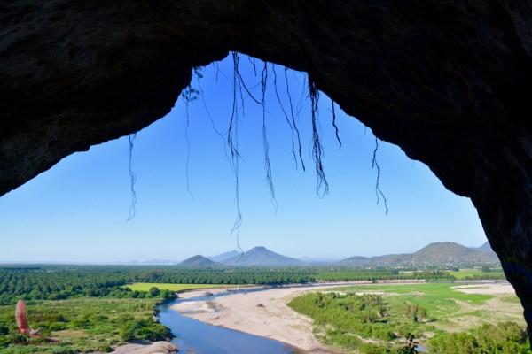 It always amazes me how we can have hugely rich archeological history very close by that goes unsung and unvalued, while we all dream about seeing the more famous sites. You know what they say about prophets in their own land, and I guess that’s true about places as well; we don’t value those nearby.


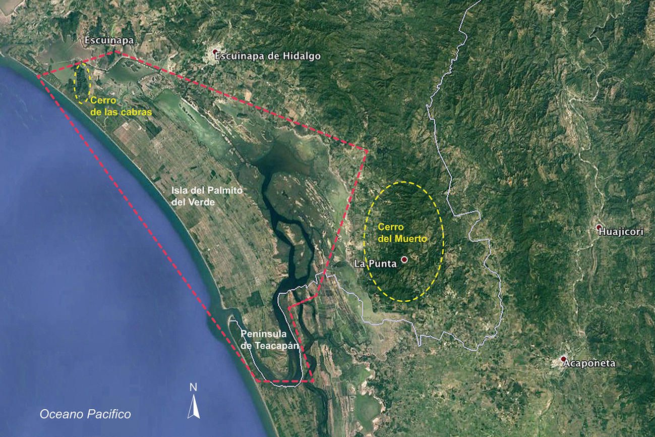


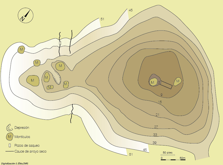

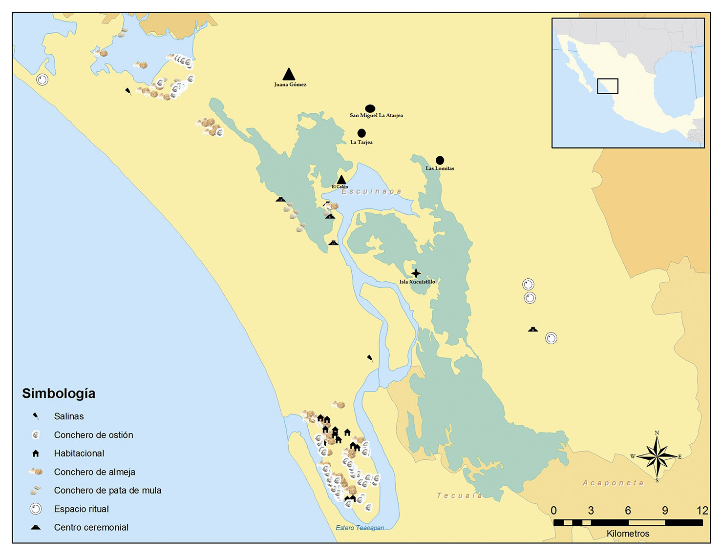


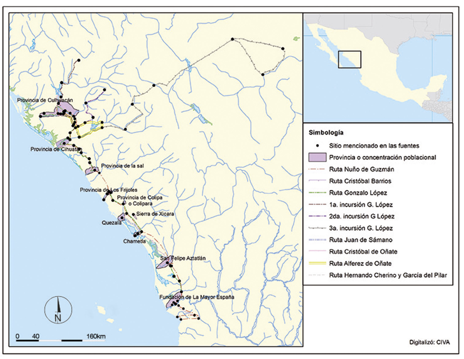
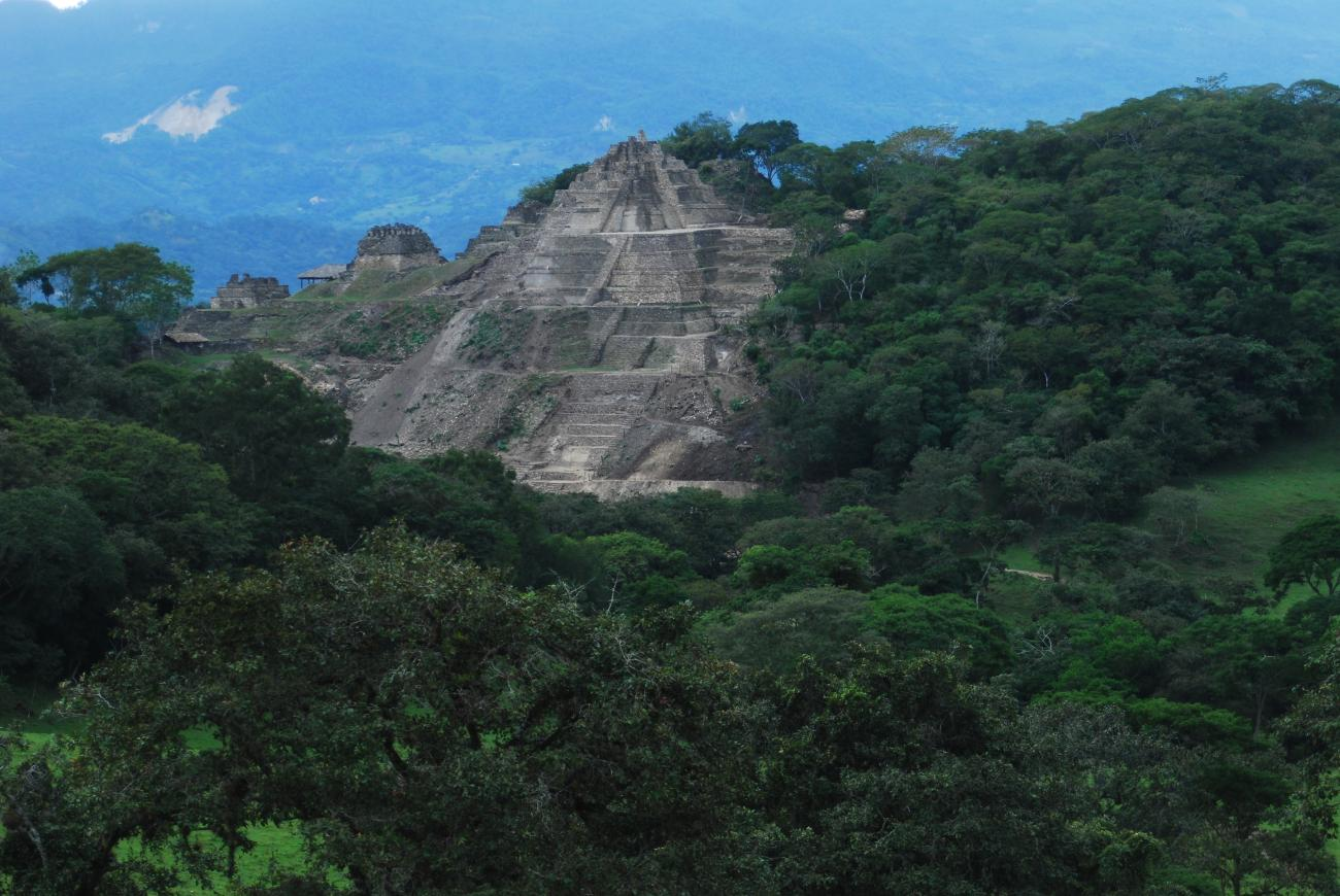
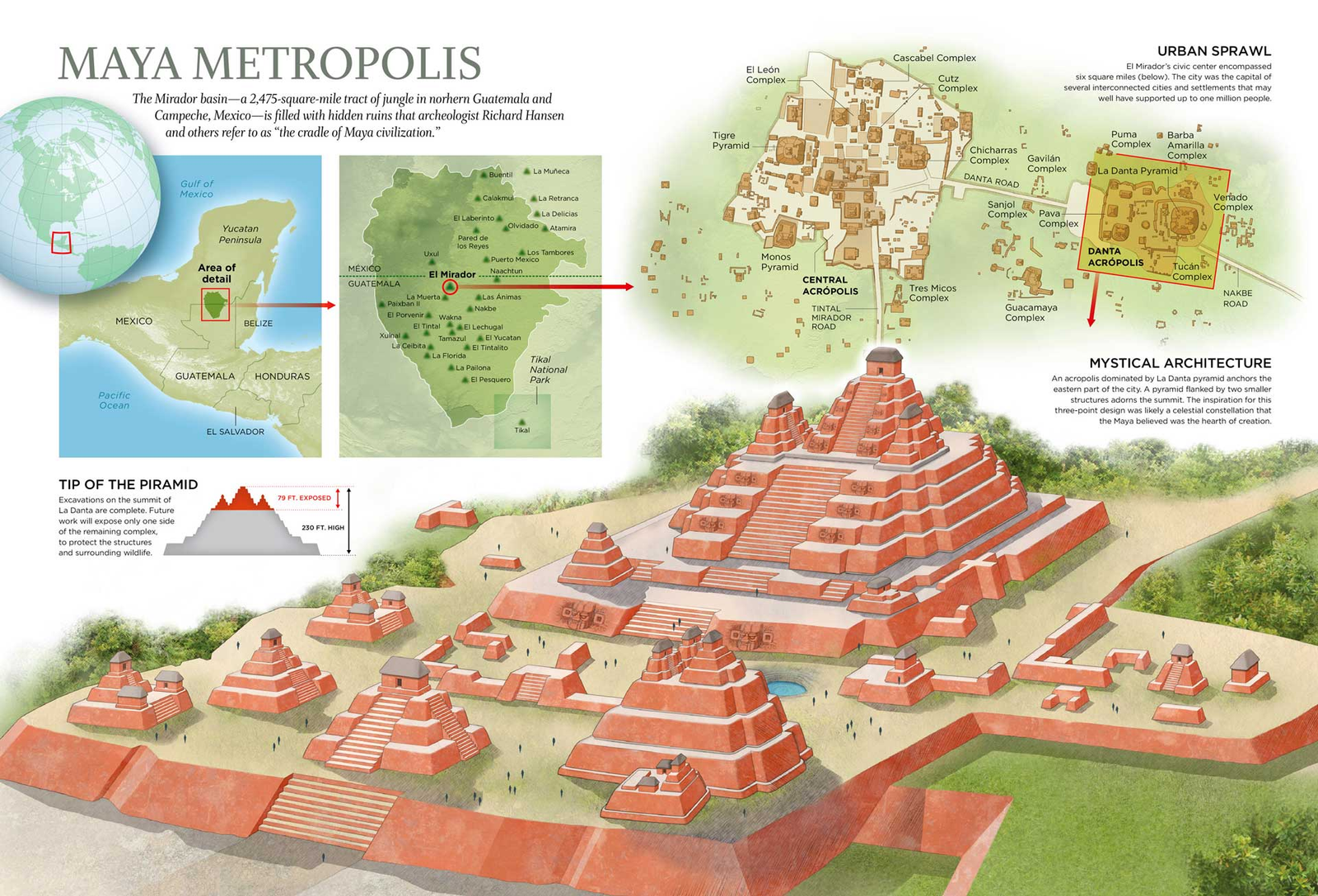
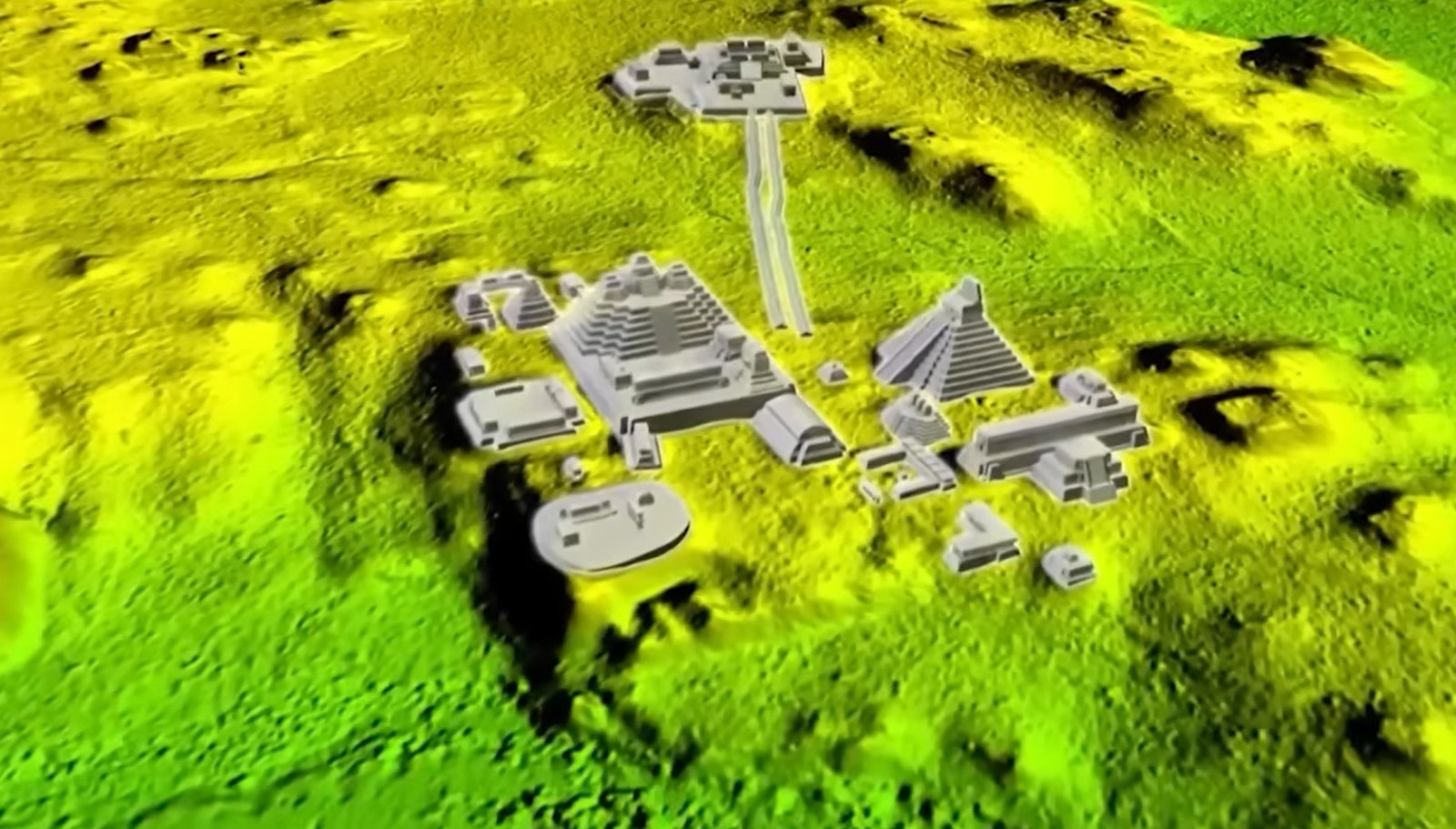
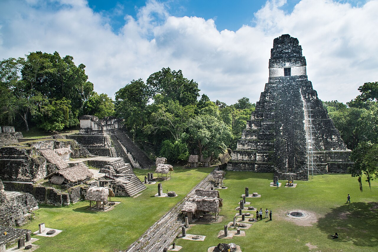

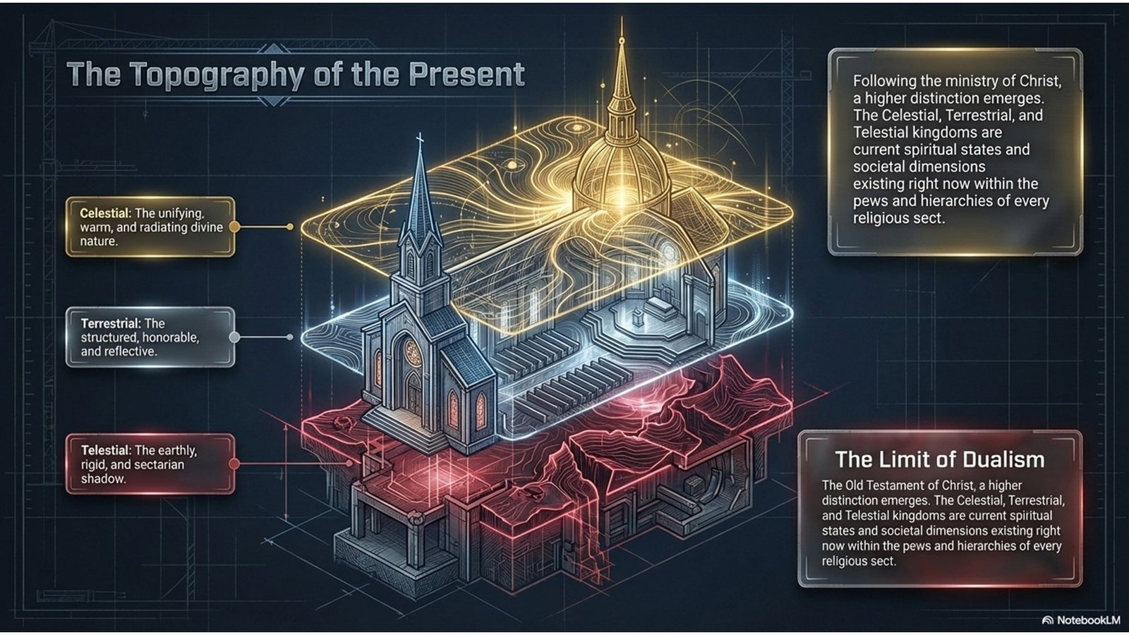
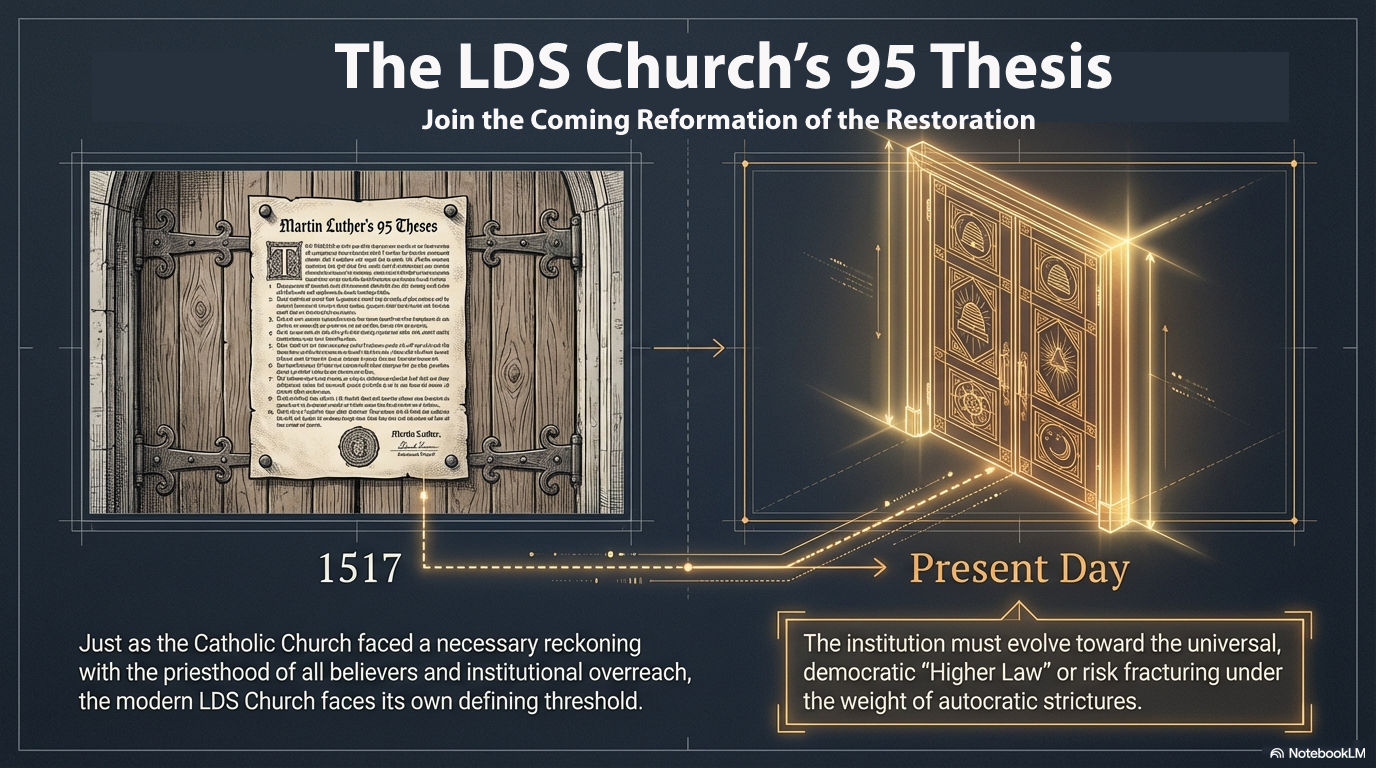


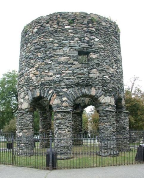


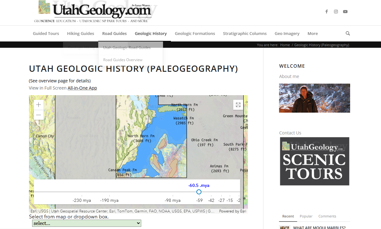
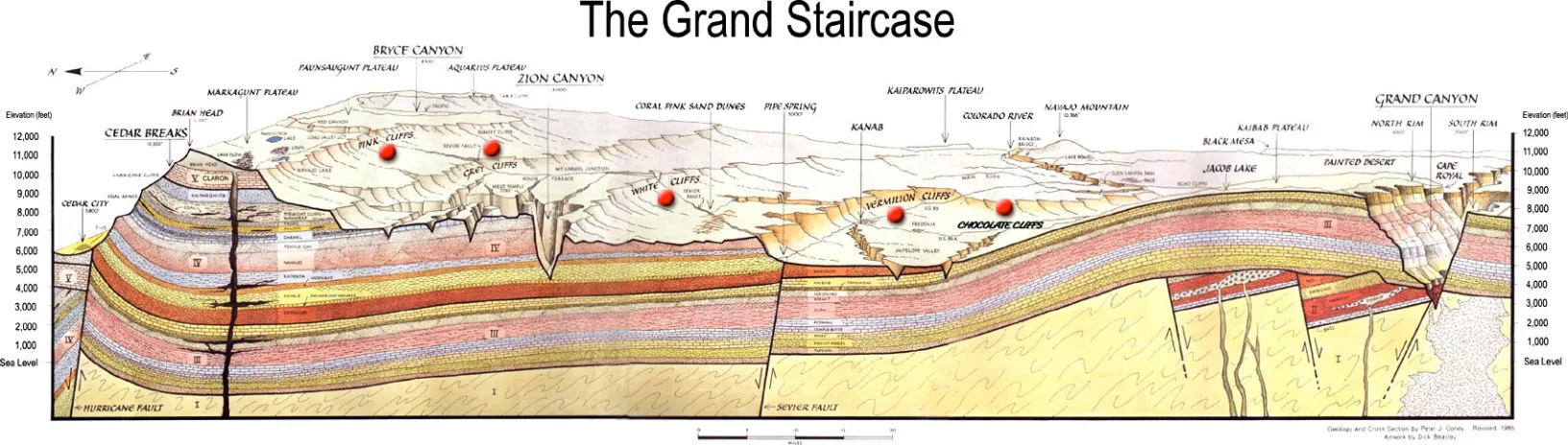
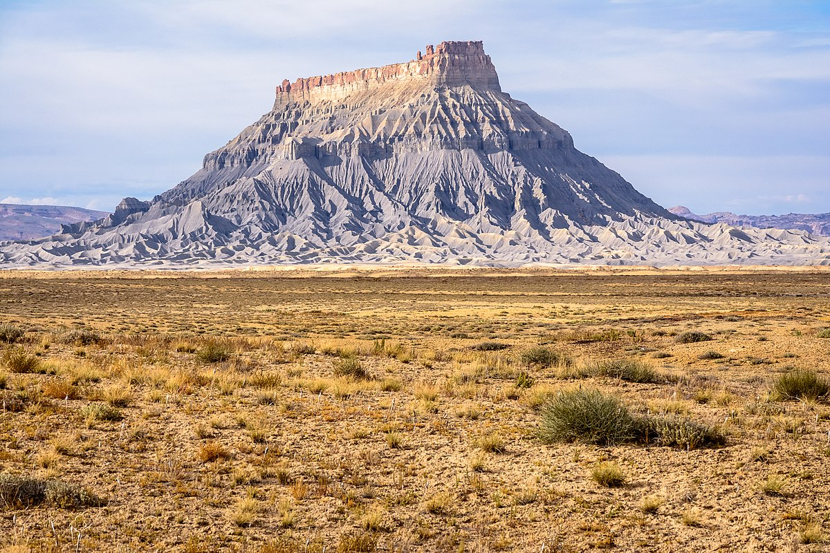