Posts

The Geologic Underworld of Jerusalem: The Caves, Tunnels & Tombs of Mount Zion & Israel’s Heritage

Overview

Jerusalem’s history is richly intertwined with the unique geology up on which in sits. From it’s spectacular abundance of limestone’s from which it is built, to its karst systems housing the spring water

Hezekiah’s Tunnel

The ancient water systems of Jerusalem have a complex history. The main water source of the original City of David was the Gihon Springs located at the base of the eastern slope of the city in the Kidron Valley. The Gihon Springs provided water year round by gushing forth several times a day. This water then naturally flowed into the Kidron Valley. In the earliest days of Jerusalem’s occupation, reservoirs where built to collect the water from the Gihon Springs. Three systems were eventually designed to use this water: The Warren’s Shaft, Siloam Channel (Tunnel) and Hezekiah’s Tunnel.

These three water systems continued to bring water to the city of Jerusalem until the days of the Hasmoneans and Herod. During the last century BC and the first century AD, aqueducts were built to transfer water into Jerusalem from the southern hill country of Judea from around Hebron and Bethlehem.

David’s city of Jerusalem as it would have appeared around 1000 BC. Gihon spring emerged from a limesone cave system charged by groundwater in the vicinity of Mount Moriah.

Hezekiah’s Tunnel

Hezekiah’s Tunnel, part of Jerusalem’s water system, is located under the City of David. It connects the Gihon Spring—Jerusalem’s fresh water supply—with the Siloam Pool. According to 2 Chronicles 32:2–4 and 2 Kings 20:20, this tunnel was dug during the reign of King Hezekiah of Judah to prepare Jerusalem for the imminent attack of the Assyrian king, Sennacherib. In the Bible, Hezekiah redirected the water through old and newly dug Jerusalem tunnels.

How Zedekiah’s Cave was Discovered

Zedekiah’s cave was possibly the biggest quarry of Jerusalem in antiquity, yet it was abandoned in the Middle ages, and eventually even its location was forgotten. It was rediscovered in 1854 by American missionary James Turner Barclay who followed the rumors of a cavern near Damascus gate. About 100 m east of the gate his dog fell into a pit. Barclay noticed the pit was quite large, but he did not want to draw any attention. At night he returned with his sons and torches. Sneaking in and operating the lights, they were the first to document the caves in modern history. They also recorded a human skeleton and batches of bats hanging from the ceiling, which kept much of the public from visiting the cave.

History of Zedekiah’s cave

zedekiah cave main hall

The cave was surveyed by several scholars and expeditions and is still under development. In fact, about a third of the cave is still filled with debris. Early researches suggested the Quarry dates to the time of King Solomon, and so it was called “Solomon’s Quarries”. Furthermore, the Free Masons order adopted the site claiming the founders of their order formed this quarry. To this day they conduct annual gatherings at the site. Current research suggests the quarry was not in use before Roman times, revoking its attribution to King Solomon or King Zedekiah.

Touring Zedekiah’s Cave

The cave is maintained by the Municipality of Jerusalem and it charges a humble admission fee. A wide flight of stairs and lights are installed in the main halls of the cave. At one of its lowest point a small flow of water is identified in Jewish tradition as “Zedekiah’s Tears”. By local tradition these are the tears of the ongoing cry of Zedekiah for the Babylonian conquest and destruction of Jerusalem.

Cave of the Patriarchs

The Cave of the Patriarchs or Tomb of the Patriarchs or Mosque of Abraham’), is a series of caves situated 30 kilometres (19 mi) south of Jerusalem in the heart of the Old City of Hebron in the West Bank. According to the Abrahamic religions, the cave and adjoining field were purchased by Abraham as a burial plot, although most historians believe the Abraham-Isaac-Jacob narrative to be primarily mythological. The site is considered a holy place in Judaism and Islam. (add pics and find story of group that explored this…)

Col. Richard Meinertzhagen, an officer under the command of General Allenby visited the tombs when the British captured Hebron in November 1917. He entered the subterranean caverns through an opening on the southwestern side of the famous above-ground structure to make sure there were no enemy forces hiding out there. Read about other visits to the tombs here

An aerial view of the Cave of the Patriarchs in Hebron

Beit Guvrin-Maresha National Park

Beit Guvrin-Maresha National Park is a national park in central Israel, containing a large network of caves recognized by UNESCO as a World Heritage Site.

The Sidonian burial caves were the family tomb of Apollophanes, the leader of the Sidonian community in Beit Guvrin. The Sidonian caves are the only ones that are painted inside. The caves were burial caves for the Greek, Sidonian and Edumite inhabitants of Beit Guvrin. The first and largest cave has paintings of animals, real and mythic, above the niches where the corpses were laid. A cock crows to scare away demons; the three-headed dog Cerberus guards the entrance to the underworld; a bright red phoenix symbolizes the life after death. The Tomb of the Musicians is decorated with a painting showing a man playing the flute and a woman playing the harp.

Sidonian Burial Caves: A series of impressive burial caves from the Hellenistic period (third–second centuries BCE), located at the foot of Tel Maresha and featuring reconstructed wall paintings. The paintings, proof of the presence of other cultures at Maresha, depict hunting scenes with wild and mythological creatures and shed light on ancient artistic techniques and crafts.
columbarium caves


The largest bell caves are in the east part of the park. They have been dug since prehistoric times, the excavations reaching their zenith in the Hellenistic period and during the Byzantine and Early Arab Period, when blocks of chalkstone extracted from the caves were used for construction work (buildings, etc.). The bell caves consist of limestone in their upper-layer (to a depth of about one to two meters), beneath which is rock consisting solely of a beige-colored, soft chalkstone, utilized by its early inhabits for carving caverns and dwellings. There are numerous bell caves within the park grounds and events are held in one of them. They are large (over 60 feet (18 m) high), airy and easily accessible

Add a section on the main aquaduct.

The REAL Age of Göbekli Tepe (NOT 9500 BC!)

Göbekli Tepe (known as Girê Mirazan or Xirabreşkê in Kurdish) is an archaeological site in the Southeastern Anatolia Region of Turkey ‘supposedly‘ dating to the Neolithic. German & Turkish archaeologists led by Klaus Schmidt have dated the site to the Pre-Pottery Neolithic between c. 9500 and 8000 BCE largely based on radiocarbon samples and the absence of pottery (see dating details).

However, several clues of the Göbekli Tepe archaeological site in Turkey make it certain that the site is NOWHERE NEAR as old as generally believed. And undoubtedly dates to the Bronze age instead of the Paleolithic.

In fact, it is incredibly common for sites in the near-east with known historic dates laying within the Hallstatt Radiocarbon Plateau of 550-750 BC to give anomalous radiocarbon determinations. And just as common for organic material buried in certain types of lime and pulverized limestone to give contaminated dates which are known to be too old. (see ManningVakninBen-Yosef, etc. See also radiocarbon considerations, volcanics & the hard water effect)

Göbekli Tepe undoubtedly falls within one of these three groups, along with many of the Pre-Pottery Neolithic A (PPNA) sites in the region, mostly correlated to stylistic similarities to Jericho. The archaeological site of Jericho in Israel suffers from the same issue of likely volcanic or lime contamination (the site lays on a blocked drainage where ancient landslides blocking the drainage likely brought sub-surface waters saturated with lime into contact with dating material). Or possibly these sites were built during the same short period of spiked non-radiogenic bearing atmospheric carbon dioxide levels (possibly from a nearby volcanic field venting event from the massive Harrat Ash Shaam field in Syria or the nearby Karaca Dag volcanics.)

The first clue which makes the incorrect radiocarbon dates of Göbekli Tepe obvious is the column artwork. Particularly the bag motif in proximity to the avian vultures. This is a well known religious motif from both Neo-Assyrian (911-609 BC) artwork and the Urartu Kingdom (858-586 BC). The ‘bucket and cone‘ or bag and dobber used prolifically in Urartu art depicted the manual pollination of date palm trees with a synthetic stamen and was used to represent fertility and potency.

All three of the archaeological sites which house the religious artwork above are found within 250 miles of each other in the region of Assyria and ancient Urartu. Many similar motifs are found in numerous similar sites in the region. The more rudimentary style of the Göbekli Tepe artwork may suggest it was made earlier than the other examples, or it may just have just been carved by less talented artists and stone masons. But for these religious stylistic motifs to be 8000 years older is incredibly unlikely and borders on ridiculous. A better earliest range possibility would be 2670 BC, the last known major eruption of the Harrat Ash Shaam volcanic field (a likely source of non-radiogenic radiocarbon contamination).

Yet another evidence for the correct late bronze to early iron age date for the site lies in its similarity to other Urartu & Phoenician sites in the region. One of the most striking examples is comparing the architecture with the Phoenician Taulas of Menorca, Balearic Island. The layout of Göbekli Tepe and Menorca sites like Torralba d’en Salord and Torre d’en Galmés are almost identical. Undoubtedly influencing each other in their T-topped columns the site dates from as early as 1310 BC to as late as 300 BC Punic occupation.

Because of their striking similarity, many might confuse the images above of the Temple or Taula on Spain’s Balearic Islands of Menorca with Göbekli Tepe. Both are built in sprawling circular layouts, often on hills with T-shaped center roof columns and equispaced outer wall columns. (somewhat like Stonehenge.) Even the smaller side wall rock work is quite similar in many respects. Perhaps the most striking similarity is the celestial alignments and multi-room, rounded shared wall features.

The various animals found on the columns of Göbekli Tepe are not some early example of paleolithic animistic religion but instead representations of well known Bronze & Iron age constellation zodiac signs. Note for instance the crab/scorpion of Göbekli Tepe in comparison to the well known Babylonian astrology kudurru depicting a turtle, which was a symbol of Enki; 1125BC-1100 BCE. (from British Museum)

Another example of this ridiculous reliance on limestone contaminated radiocarbon dates of basketry is the Qumran area Muraba’at Cave, where a “Pre-Pottery Neolithic A” woven reed basket was found amidst numerous other artifacts, including a new dead-sea scroll fragment ALL clearly dating from 200 BC to 135 AD. The reed basket radiocarbon dating by Prof. Elisabetta Boaretto of the Weizmann Institute of Science in Rehovot, the IAA, dated to 9,500 BC. Yet, a nearby skeleton (also obviously contaminated) radiocarbon dated to 4000 BC. While the caves artifacts mostly dated by coins, writing and other non-radiocarbon means all dated to around the turn of the Christian era. This kind of lack of recognition of date corruption is horrible science, but sadly has become a regional staple in the Pre-Pottery Neolithic dating sequence.

Cache of Bar Kokhba coins. Dating from the time of the Bar Kokhba revolt (115 CE) Found in the same cave as the ‘6000 BP’ burial, and 10500 BP basket! Parchment and Seeds were also found (Crappy & intellectually dishost archaeologist did not publish the radiocarbon dates of the seeds)

Pre-Pottery Neolithic A (PPNA) sites: Jericho, Hallan Cemi. Jerf el-Ahmar (9500 – 8700 BC) in present day Syria

Parallel of Egyptian Monumental Kinglists

A visual comparison of the cartouches on the three inscribed king list.

The three major New Kingdom king lists inscribed in stone are:

The Abydos and Saqqara lists contain two rows of cartouches organised with the names of the pharaohs inscribed in sequential order on a single flat wall. The Karnak list contain 4 rows inscribed on three connected walls and the cartouches are not in sequential order. It is further divided into a left and right part where the pharaohs face the same direction.

For more information about the lists, check their respective page.

PharaohAbydosSaqqaraKarnak
Narmercartouche
mni
Ahacartouche
tti
Djercartouche
itti
Wadjcartouche
itꜤ
Dencartouche
spꜢti
Anedjibcartouche
mr-bꜢp
cartouche
mri-biꜢpn
Semerkhetcartouche
smsw
Qa’acartouche
ḳbḥ
cartouche
ḳbḥw
Hotepsekhemwycartouche
bḏꜢw
cartouche
nṯr-bꜢw
Nebracartouche
kꜢkꜢw
cartouche
kꜢkꜢw
PharaohAbydosSaqqaraKarnak
Ninetjercartouche
bꜢ-nṯr
cartouche
bꜢ-nṯrw
Wadjnescartouche
wꜢḏ-ns
cartouche
wꜢḏ-ls
Senedjcartouche
sndi
cartouche
snḏ
Neferkaracartouche
nfr-kꜢ-rꜤ
Neferkasokarcartouche
nfr-kꜢ-zkr
Hudjefa Icartouche
//-ḏfꜢ-//
Khasekhemwycartouche
ḏꜢ-ḏꜢ-y
cartouche
bby
Nebkacartouche
nb-kꜢ
Djosercartouche
ḏsr-sꜢ
cartouche
ḏsr
Sekhemkhetcartouche
tti
cartouche
ḏsr-tti
PharaohAbydosSaqqaraKarnak
Hudjefa IIcartouche
sḏs
cartouche
nb-kꜢ-rꜤ
?cartouche
nfr-kꜢ-rꜤ
cartouche
nfr-kꜢ-rꜤ
Hunicartouche
ḥwni
Sneferucartouche
snfrw
cartouche
snfrw
cartouche
snfrw
Khufucartouche
ḫfw
cartouche
ḫfw(f)
Djedefracartouche
ḏd(w)-f-rꜤ
cartouche
ḏd-f-rꜤ
Khafracartouche
ḫꜤ-f-rꜤ
cartouche
ḫꜤ(w)-f-rꜤ
Menkauracartouche
mn-kꜢw-rꜤ
cartouche
Shepseskafcartouche
šps-kꜢf
cartouche
?cartouche
PharaohAbydosSaqqaraKarnak
?cartouche
?cartouche
Userkafcartouche
wsr-kꜢf
cartouche
wsr-kꜢf
Sahuracartouche
sꜢḥ.w-rꜤ
cartouche
sꜢḥ.w-rꜤ
cartouche
sꜢḥ.w-rꜤ
Neferirkaracartouche
kꜢ-kꜢ-i
cartouche
nfr-ir-kꜢ-rꜤ
Shepseskaracartouche
šps-kꜢ-rꜤ
Neferefracartouche
nfr-f-rꜤ
cartouche
ḫꜤ-nfr-rꜤ
Niuserra Inicartouche
ni-wsr-rꜤ
cartouche
ini
Menkauhorcartouche
mn-kꜢw-ḥr
cartouche
mn-kꜢw-ḥr
Djedkara Isesicartouche
ḏd-kꜢ-rꜤ
cartouche
mꜢꜤ-kꜢ-rꜤ
cartouche
issi
PharaohAbydosSaqqaraKarnak
Unascartouche
wn-i-s
cartouche
wn-i-s
Teticartouche
tti
cartouche
tti
cartouche
tty
Userkaracartouche
wsr-kꜢ-rꜤ
Pepi Icartouche
mr-y-rꜤ
cartouche
ppy
cartouche
ppy
Nemtiemsaf Icartouche
mr-n-rꜤ
cartouche
mr-n-rꜤ
cartouche
mr-n-rꜤ
Pepi IIcartouche
nfr-kꜢ-rꜤ
cartouche
nfr-kꜢ-rꜤ
Nemtiemsaf IIcartouche
mr-n-rꜤ sꜢ-m-sꜢ-f
Netjerikaracartouche
nṯr-kꜢ-rꜤ
Menkaracartouche
mn-kꜢ-rꜤ
Neferkara IIIcartouche
nfr-kꜢ-rꜤ
PharaohAbydosSaqqaraKarnak
Neferkara Nebycartouche
nfr-kꜢ-rꜤ nby
Djedkara Shemaicartouche
ḏd-kꜢ-rꜤ šmꜢi
Neferkara Khenducartouche
nfr-kꜢ-rꜤ ḫndw
Merenhorcartouche
nfr-kꜢ-rꜤ
Neferkamincartouche
z-nfr-kꜢ
Nikaracartouche
ni-kꜢ-rꜤ
Neferkara Tererucartouche
nfr-kꜢ-rꜤ tr-rw
Neferkahorcartouche
nfr-kꜢ-ḥr
Neferkara Pepisenebcartouche
nfr-kꜢ-rꜤ ppy-snb
Neferkamin Anucartouche
z-nfr-kꜢ Ꜥnw
PharaohAbydosSaqqaraKarnak
Qakara Ibicartouche
ḳꜢ-kꜢw-rꜤ
Neferkauracartouche
nfr-kꜢw-rꜤ
Neferkauhorcartouche
nfr-kꜢw-ḥr
Neferirkara IIcartouche
nfr-ir-kꜢ-rꜤ
Mentuhotep IIcartouche
nb-ḥꜢpt-rꜤ
cartouche
nb-ḥꜢpt-rꜤ
cartouche
nb-ḥꜢpt-rꜤ
Mentuhotep IIIcartouche
s-Ꜥnḫ-kꜢ-rꜤ
cartouche
s-Ꜥnḫ-kꜢ-rꜤ
cartouche
s-nfr-kꜢ-rꜤ
Amenemhat Icartouche
s-ḥtp-ib-rꜤ
cartouche
s-ḥtp-ib-rꜤ
cartouche
s-ḥtp-ib-rꜤ
Senusret Icartouche
ḫpr-kꜢ-rꜤ
cartouche
ḫpr-kꜢ-rꜤ
cartouche
ḫpr-kꜢ-rꜤ
Amenemhat IIcartouche
nbw-kꜢw-rꜤ
cartouche
nbw-kꜢ-rꜤ
cartouche
nbw-kꜢw-rꜤ
Senusret IIcartouche
ḫꜤ-ḫpr-rꜤ
cartouche
ḫꜤ-ḫpr-rꜤ
PharaohAbydosSaqqaraKarnak
Senusret IIIcartouche
ḫꜤ-kꜢw-rꜤ
cartouche
ḫꜤ-kꜢ-rꜤ
cartouche
ḫꜤ-kꜢ-rꜤ
Amenemhat IIIcartouche
nj-mꜢꜤt-rꜤ
cartouche
nj-mꜢꜤt-rꜤ
Amenemhat IVcartouche
mꜢꜤ-ḫrw-rꜤ
cartouche
mꜢꜤ-ḫrw-rꜤ
cartouche
mꜢꜤ-ḫrw-rꜤ
Neferusobekcartouche
sbk-kꜢ-rꜤ
cartouche
sbk-nfrw-rꜤ
Wegafcartouche
ḫw-tꜢwi-rꜤ
Sekhemra Khutawycartouche
sḫm-rꜤ ḫw-tꜢwi
Amenemhat V ???cartouche
s-Ꜥnḫ-ib-rꜤ
Neferhotep Icartouche
ḫꜤ-sḫm-rꜤ
Sobekhotep IVcartouche
ḫꜤ-nfr-rꜤ
Sobekhotep Vcartouche
ḫꜤ-ḥtp-rꜤ
PharaohAbydosSaqqaraKarnak
Sobekhotep VI Merhotepracartouche
mr-ḥtp-rꜤ
Mersekhemra Inedcartouche
mr-sḫm-rꜤ
Sobekhotep VIIcartouche
mr-kꜢw-rꜤ
Senebmiucartouche
s-wꜢḥ-n-rꜤ
Rahotepcartouche
wꜢḥ-kꜢw-rꜤ
Sobekemsaf Icartouche
sḫm-wꜢḏ-kꜢw-rꜤ
Djehutycartouche
sḫm-rꜤ s-mn-tꜢwi
Sobekhotep VIIIcartouche
sḫm-rꜤ s-wsr-tꜢwi
Nebiraucartouche
s-wꜢḏ-n-rꜤ
Bebiankhcartouche
s-wsr-n-rꜤ
PharaohAbydosSaqqaraKarnak
Intef VIIcartouche
nbw-ḫpr-rꜤ
Senakhtenra Ahmosecartouche
s-nḫt-n-rꜤ
Seqenenracartouche
s-ḳn-n-rꜤ
Ahmosecartouche
nb-pḥti-rꜤ
cartouche
nb-pḥt(i)-rꜤ
Amenhotep Icartouche
ḏsr-kꜢ-rꜤ
cartouche
ḏsr-kꜢ-rꜤ
Thutmose Icartouche
ꜤꜢ-ḫpr-kꜢ-rꜤ
cartouche
ꜤꜢ-ḫpr-kꜢ-rꜤ
Thutmose IIcartouche
ꜤꜢ-ḫpr-n-rꜤ
cartouche
ꜤꜢ-ḫpr-n-rꜤ
Thutmose IIIcartouche
mn-ḫpr-rꜤ
cartouche
mn-ḫpr-rꜤ
Amenhotep IIcartouche
ꜤꜢ-ḫprw-rꜤ
cartouche
ꜤꜢ-ḫprw-rꜤ
Thutmose IVcartouche
mn-ḫprw-rꜤ
cartouche
mn-ḫprw-rꜤ
PharaohAbydosSaqqaraKarnak
Amenhotep IIIcartouche
nb-mꜢꜤt-rꜤ
cartouche
nb-mꜢꜤt-rꜤ
Horemhabcartouche
ḏsr-ḫprw-rꜤ stp-n-rꜤ
cartouche
ḏsr-wprw-rꜤ stp-n-rꜤ
Ramesses Icartouche
mn-pḥti-rꜤ
cartouche
mn-pḥti-rꜤ
Seti Icartouche
mn-mꜢꜤt-rꜤ
cartouche
mn-mꜢꜤt-rꜤ
Ramesses IIcartouche
wsr-mꜢꜤt-rꜤ stp-n-rꜤ

Selected Bibliography

Abydos king list

  • Mariette, AugusteAbydos description des fouilles, Vol 1, Plate 43 (Paris 1869)
  • Duemichen, JohannesHistorische inschriften altägyptischer denkmäler, Vol 2, Plate XLV (Leipzig 1869)
  • Kitchen, Kenneth A.Ramesside Inscriptions, Vol. I, pp. 176-179 (Oxford 1975)
  • Porter and MossThe Topographical Bibliography of Ancient Egyptian hieroglyphic texts, reliefs, and paintings, Vol. VI, 25 (229)-(230)

Karnak king list

  • Burton, JamesExcerpta Hieroglyphica, (Cairo 1825)
  • Young, ThomasHieroglyphics, Vol. 2, (London 1828) Plate 96 (copy from Burton)
  • Wilkinson, J. G.Extracts from several Hieroglyphical Subjects found at Thebes, and other parts of Egypt, (Malta 1830) Plate IV
  • l’Illustration, Journal Universel, Vol. VII, p 244-245, (Paris 1846)
  • d’Avennes, PrisseMonuments Égyptiens, bas-reliefs, peintures, inscriptions, etc., (Paris 1847) Plate I
  • Lepsius, Karl RichardÜber die zwölfte Aegyptische Königsdynastie in “APAW 1852” pp. 425-455, (Berlin 1853) Plate I
  • Sethe, KurtUrkunden der 18. dynastie, IV.8-198, p. 607-610 (Leipzig, 1906)

Saqqara king list

  • Mariette, AugusteLa table de Saqqarah in Revue Archeologique, Vol 10, (Paris 1864) p. 169-186, Plate XVII
  • Mariette, AugusteMonuments divers recueillis en Égypte et en Nubie, (Paris 1872) Vol. II, Pl. 57b, 58, text Vol. I, p. 18-19
  • Meyer, EduardÄgyptische Chronologie, Plate 1, (Berlin 1904)
  • Kitchen, Kenneth A.Ramesside Inscriptions, Vol. III, pp. 481-482 (Oxford 1980)

Egyptian Chronology Resources

The Reliefs of Dur-Sharrukin as Plunder from Solomon’s Temple

18 All the walls were decorated with carvings of cherubim… and there was a carving of a palm tree between each of the cherubim… carved all along the inside of the Temple, …from the floor to the top of the walls, including the outer wall of the sanctuary…” (Ezek 41:18–20) On the walls all around the temple, in both the inner and outer rooms, he carved cherubim, palm trees and open flowers. (1 Kings 6:29)

Background

The following information came to me in a dream. I was awoken early in the morning to a voice in my head not unlike other experiences I have had from time to time when working on religious research or scripture/archaeological correlations. This voice spoke with me about the eagle and handbag motif I had recently been studying from the Assyrian temple compound of Dur-Sharrukin and its relationship to the Mesoamerican site of La Venta’s bird masked relief with a similar hand bag. After tracking the similarities between these reliefs and the temple rites found in the Kolbrin, I began assuming these were somehow related to the Northern Kingdom of Israel. Because the Assyrian reliefs date to around 720 BC, my assumption was that King Ahaz or some other Northern Kingdom monarch had spread his cultural ideas into Assyria some time before 720 BC. However, the angelic voice told me “No! These reliefs are from the Jerusalem temple and are related to Daniel.” As has been the case in other similar occasions, my mind seemed linked with a higher intelligent and I could ‘see’ everything I was being told clearly, all of it making perfect sense.

Similarities between the Mesoamerican La Venta monument #19, and Assyrian palace reliefs (note the bag & eagle head)

However, when I woke up and began thinking about this I quickly dismissed it because of many issues that just didn’t line up for me. The timing was wrong with it predating the Babylonian destruction by around 120 years. The location was wrong, because it was way too far north in Assyrian territory, and not down by the delta where most believe Babylon was. And most of all, it seemed impossible that Israel would have reliefs of animals that seemed so idolatrous to me in the temple compound. However, there were scriptures from Ezekiel and Isaiah in my mind from the visionary dream, which later in the day I decided to look up.

One after another, as I read the scriptures that talked about the temple, I was blown away. They matched NEARLY PERFECTLY with what I learned in the dream. But even then, I just could not get past the stumbling blocks of the location and date. However, as I continued to research on the source for the dates of this site, as well as the Assyrian king names I began to see how they could be misidentified and misdated. The most significant of these being the idea shown below of Nebuchadnezzar’s Babylonian Hanging Gardens actually being the Assyrian city of Nineveh. I still haven’t worked out the details, but it appears possible that Nebuchadnezzar II (or an earlier of his dynasty), conquered these Assyrian cities and made them his northern capital (with a secondary capital down near the traditional sites near the Delta). And that this could be why archaeologist have not found Nebuchadnezzar’s Babylonian garden tower, palace or evidence of him conquering Egypt or Jerusalem or much evidence for the Jedeo-Babylonian captivity. Because they have misattributed the Babylonian evidence to Assyrian kings. Below is a ‘work in progress’ article on the results of my research stemming from my dream.

Introduction

Has the artwork of Solomon’s temple been lost in plain sight for 200 years? The artwork at the top of the page comes from the archaeological site of Dur-Sharrukin near the village of Khorsabad in northern Iraq.

Lost to history in antiquity, the site was first excavated in 1843 by Henry Layard… (finish into)

So how did archaeologists confuse the Nebuchadnezzar II famous city of Babylon which housed Daniel and the deported Jews with the Assyrian city of Nimrud? Renowned Assyriologist Stephanie Dalley has essentially worked that out in her groundbreaking book “The Mystery of the Hanging Garden of Babylon: An Elusive World Wonder Traced.” In it, she theorizes that the accounts Nebuchadnezzar II Hanging Gardens of Babylon might actually be the Great Ziggurat found in Nineveh. (flesh this out)

However, I believe that all her evidence and reasoning actually also works in reverse. Instead of her reasoning that archaeologists are right and Greco-Roman historians are wrong concerning the identity of the city with the Hanging Gardens, it is just as possible that the Greco-Roman historians are right and the archaeologists are wrong in where they think the hanging gardens should be! Perhaps instead, Nebuchadnezzar II actually had TWO palaces, one in the southern delta near Bagdad, and another northern capital where he reoccupied the conquered Assyrian cities near Mosul. And it is THIS northern capital of Babylon (Old Nineveh) where he built his hanging gardens, deported the Jews to, and adorned it with all the hundreds of stolen panels from the Jerusalem temple! These panels were then taken by Nebuchadnezzar II’s two successors and used to decorate their palaces as well (Nimrud & Dur-Sharrukin). [reference a more detailed description below]

This is why Stephanie Dalley found that the tombs of Nimrud contained Hebrew queens, likely from the kingdom of Judah instead of Samarian queens from Northern Israel. (see the rest of her exhaustive evidence in her book)

In addition to the Hebrew Queens Tombs, substantial evidence for this theory also exists in the Nimrud Ivories. This stash of thousands of small ivory carvings are known to have originated almost exclusively from the Levant (Israel) and Egypt. In addition to the obvious foreign artwork they also contain numerous Phoenician and proto-Hebrew inscriptions, along with an overwhelming number of motifs which tie supposed Assyrian Wall Relief artwork to Egypt and Israel. By looking through the thousands of images, one can see the evolution of the motifs from their Egyptian roots into the more “Assyrian” (Israeli) motifs seen in the wall panels. (see whitepapers here & here)

Selected ‘Nimrud Ivories‘ found buried in the same Assyrian Palaces as the wall reliefs. The ivories were clearly taken from locations with Egyptian, Phoenician and proto-Hebrew provenance and brought to Assyria.

Just as parts of the Nimrud Ivories are clearly from Phoenicia, the Levant (Israel) and Egypt, The wall reliefs of Nimrod and Dur-Sharrukin seem to have motifs straight out of the Jewish biblical record. They also bare striking resemblance to many earlier Assyrian, Babylonian, Hittite and Urartian art pieces dating from the sixth to tenth centuries. It seems logical from the biblical evidence I’m about to present, that the biblical artwork and religious motifs mentioned below were part of a regional cultural tradition which stretched from Israel into Babylon, Assyria, Turkey, Persia and even Armenia. This also fits into the biblical record where Biblical kings David & Saul conquered territory stretching to the Euphrates river and presumably allowed Israelite peoples to immigrate northward into Syria & Turkey from as early as 1000 BC. Elsewhere I make a case for the aggressive spread of this same religious iconography & culture into areas of the New World through the ancient port city of La Venta.

Various art pieces showing the winged demigod with bucket and cone sacred date palm motifs. top left: Urartu Khaldi from wikipedia. top right: Khaldi from reign of King Rusa II (685–645 BCE) from Kef Kalesi, Adilcevaz, Eastern Turkey. bottom left: Khaldi from Rusahinili fortress, Turkey. Ancient pages. bottom right: bronze Urartu  helmet from Argishti I’s era. The “tree of life” citadel of Erebuni, Armenia 782 BC (Wikipedia).

After looking through the art Assyrian art motifs above and below, not similarities between these art pieces and reliefs and biblical scriptures like Ezekiel’s vision which gives some details of what the Cherubim in Solomon’s temple looked like. He says Ezekiel 9-10

“Their faces looked like this: In front a human face, on the right side the face of a lion, on the left the face of an ox, and in back the face of an eagle. So much for the faces. The wings were spread out with the tips of one pair touching the creature on either side” (Ezek 1:10–11)
“the first face was the face of a cherub [or ‘bull‘ see CEV], the second face the face of a man, the third the face of a lion, and the fourth the face of an eagle.” (Ezek 10:14)


In case there’s any question that Ezekiel’s vision is employing exact temple imagery, compare what he says of the cherib’s wings with what is described in the description of the Cherubim in the Holy of Holies of Soloman’s temple, patterned after those on the top of the Ark of the Covenant.

Biblical Ark of the Covenant illustrated in Egyptian style by Raanan Eichler, a Ph.D. of the Department of Bible at the Hebrew University of Jerusalem. (Since the Hebrews had been in Egypt for over 200 years!)

10 …the wings were spread out with the tips of one pair touching the creature on either side… he four creatures looked like a blazing fire, or like fiery torches ” (Ezek 1:9–13)
27 He placed the cherubim inside the innermost room of the temple, with their wings spread out. The wing of one cherub touched one wall, while the wing of the other touched the other wall, and their wings touched each other in the middle of the room. 28 He overlaid the cherubim with gold. (1 Kings 6:27–28)

After more than 200 years in Egypt, the cherub of the Arc as well as those later put on the walls and in the holy of holies of Solomon’s temple were almost certainly adaptations from the sacred iconography of Egypt. For instance, in the temple of Ma’at in Kom Ombo Egypt we see an incredibly similar motif with the Goddess Ma’at acting as a Cherub (in similar style to the faravahar we’ll talk about in a moment) kneeling next to a lion and falcon, each with 6-8 outstretched wings. (note the bull as well).

Although this particular depiction dates from the Ptolmaic period of Egypt, winged depictions of Maat exist as early as in the Pyramid Texts of Unas (ca. 2375 BCE)
[Add image and description of wheels within wheels and metonic cycle here. https://commons.wikimedia.org/wiki/File:Assyrian_Reliefs_Nimrod_North_West_Palace_-_Castle.JPG]


.

The Palace Garden Scene

Believed to be Assyrian King Ashurbanipal in a scene celebrating the head of the Elamite king Teumman, this scene makes far more sense as a depiction of the events of 2 Samuel 20:3–22 Where David returns to his palace with 10 concubines from the city of Abel Beth Maakah. The preeminent woman is “the wise woman” from verse 14 who saved the city by convincing the people to give General Joab the head of the rebel Sheba (which here is seen hanging in the fir tree). The story is also depicted in midlevel art. Note also that the garland above the king seems to be composed of the same fig leaves and grapes so often associated with David in the bible and artwork in Solomon’s temple.

King Ashurbanipal ‘Garden Scene’, British Museum. Better interpreted as David in a scene from 2 Samuel 20:3–22

The Kings Library

Jewish tradition (ref) and biblical references (such as 2 Kings 22:8) state that the Jewish temple housed a great library. Is it mere coincidence then that the same palace of Ashurbanipal, housing all these reliefs which so perfectly resemble those of Solomon’s temple and palace, was also the home of the oldest surviving and perhaps most important royal library in Mesopotamia? The library housed up to 22,000 collected tablets in multiple languages. See details here. With perhaps the most complete version of the preeminent Epic of Gilgamesh, which also serves as the foundational mythic tale in the Kolbrin (therein called the story of Hurmanetar)

Ashurbanipal’s Library, British Museum.

The Flower Laced Palm Tree

Palm trees held a special place in ancient Israeli religion, being an important part of the Exodus myth, there bing12 wells and 70 palm trees in the first stop after Moses took Israel across the read sea and healed the waters in Exodus 15. Afterwards palm fronds were made to be an important part of the festival of Booths (Lev 23:40–41). Perhaps because of this, combined with the supreme importance of the Date Palm industry in ancient Israel’s economy, Solomon placed cheribum, lions and palm trees on the inner and outer walls of the temple, as well as on the panels covering the wheels of the portable water basins or arcs.

“He engraved cherubim, lions and palm trees on the surfaces of the supports and on the panels, in every available space, with wreaths [לֹיָה, garlands?] all around” (1 Kings 7:36)

More specifically, 2 Chronicles 3:5 says the Cherubim were associated with “palm trees and chains”. And that’s not chains like you’d keep a captive in, but וְשַׁרְשְׁרֽוֹת׃ or decorative jewelry chainwork, sometimes translated as “twisted chain work cordage” (stongs) or translated in NAS Ex 28:14 as filigree. Which if you’re not familiar with a flowered filigree, it’s basically a vine-like floral design. You can see examples here.

As in the picture above, filigrees are often associated with flowers, and those in Solomon’s temple appear to be no different. In 1 Kings 6:29, we see that open flowers were an important part of the chained or garlanded palm trees.

On the walls all around the temple, in both the inner and outer rooms, he carved cherubim, palm trees and open flowers. (1 Kings 6:29)

I’m not sure how to better describe the “Assyrian Trees of Life”, than the bible’s description of the corded/chained palms with open flowers of Solomon’s temple. And these would have been not just on the inside of the temple, but in the “outer rooms”, as well as on the panels of the wagons used for the movable arcs (ref)

The date palm and Cherub scenes were both inside the temple (completely coated with hammered gold), but also in the outer rooms.
The same types of reliefs were on each panel of the movable arcs. Making them especially easy to take back to Babylon. (find a pic of Assyrian relief, and Photoshop onto one of these (they likely hid the wheels)

In fact this same palm tree garland design is repeated in the two massive brass columns in the front of the temple. These were instructed to have massive lily pedals on top which likely mimicked palm fronds. In 1 Kings 7:15–22 it also states that the capitals or “caps” on the columns were to have “checker-work with wreaths of chain work” likely forming a pattern similar to the palm trees we’ve been talking about.

Ezekiel in his vision, which obviously drew on temple imagery, he adds the detail that these peculiar chained/flowered palms were between two cherubs. Cherubs which in some cases looked like a man and in other cases had the face of lions.

“18 All the walls were decorated with carvings of cherubim, each with two faces, and there was a carving of a palm tree between each of the cherubim. 19 One face, that of a man, looked toward the palm tree on one side. The other face, that of a young lion, looked toward the palm tree on the other side. The figures were carved all along the inside of the Temple, …from the floor to the top of the walls, including the outer wall of the sanctuary…” (Ezek 41:18–20)
25 The doors leading into the sanctuary were decorated with carved cherubim and palm trees, just as on the walls. And there was a wooden roof at the front of the entry room to the Temple. On both sides of the entry room were recessed windows decorated with carved palm trees. (Ezek 41:18–20)

Honestly its hard to see how the world has missed the obvious likelihood that these “Assyrian” reliefs of Ashurbanipal are actually plunder from Solomon’s temple, taken by Nebuchadnezzar II and placed in his palace.

Supposedly, An Ugallu—with the head of a lion, body of a man, and feet of an eagle, North Palace of Ashurbanipal at Nineveh, British Museum.
More protective Ugallu or supposed ‘lion spirits’. British Museum

now put a close up of the full cherubim scene… find this high detail. https://www.dreamstime.com/editorial-photo-anunnaki-tree-life-relief-panel-metropolitan-museum-art-manhattan-new-york-ny-ancient-near-eastern-assyrian-royal-image65121271

Pslams give a convincing background for both the lion slaying scenes and the dragon slaying scene. It says.

“3 Surely he will save you… 5 You will not fear the terror of night… For he will command his angels [Seraphim?] concerning you to guard you in all your ways; 13 You will tread on the lion and the cobra; you will trample the great lion and the [dragon]. (Pslams 91:13)

Supposedly, Ninurta with his thunderbolts pursues Anzû stealing the Tablet of Destinies from Enlil‘s sanctuary (Austen Henry Layard Monuments of Nineveh, 2nd Series, 1853)

Note also that many of the Cherubim have two sets of wings, or FOUR wings in addition to their arms, just as said in Ezekiel.

Each had… four wings, and under their wings was what looked like human hands [arms]. (Ezek 10:21)

Many of the motifs are combined in this following mural. With so called Assyrian winged genie who are actually biblical cheribum standing before the Tree of Life represented by the chained palm tree (talk about fertility of palm fertilizations), above it are the protective wings of the Lord

5 Also out of the midst thereof came the likeness of four living creatures. And this was their appearance; they had the likeness of a man. 6 And every one had four faces, and every one had four wings. 7 And their feet were straight feet; and the sole of their feet was like the sole of a calf’s foot: and they sparkled like the colour of burnished brass. 8 And they had the hands of a man under their wings on their four sides; and they four had their faces and their wings. 9 Their wings were joined one to another; they turned not when they went; they went every one straight forward. 10 As for the likeness of their faces, they four had the face of a man, and the face of a lion, on the right side: and they four had the face of an ox on the left side; they four also had the face of an eagle. 11 Thus were their faces: and their wings were stretched upward; two wings of every one were joined one to another, and two covered their bodies. (Ezekiel 1:5–11)

see https://www.metmuseum.org/toah/hd/nimr_2/hd_nimr_2.htm
Supposedly, Assyrian Tree of Life motif or zigzaggy tree flanked by a pair of winged genii, British Museam

Note that in Isaiah he also utilizes temple motifs in his vision… He sees a beast with 6 wings which may well have been a motif somewhere in the temple, as existing reliefs vary in the number of wings from none, to four in one relief.

Above it stood the seraphims: each one had six wings; with twain he covered his face, and with twain he covered his feet, and with twain he did fly. (Isaiah 6:2)

Talk about the Eagle thing that’s thought to be Persian, and how its found in Darius Wall and in Roman Mithraic temple’s. Understanding its true source in Judaism, helps tie these cultures together, as the Kolbrin shows the jewish roots of Mithra, and Darius, “worshipped the Lord” (ref) and was a follower of … The wings as a symbol of Jehovah in the temple can be seen in the following Psalms

7 In my distress I called to the Lord; I called out to my God. From his temple he heard my voice; 10 He parted the heavens and came down… 11 He mounted the cherubim and flew; he soared on the wings of the wind. (2 Sam 22:7–11)
4 He will cover you with his feathers, and under his wings you will find refuge. (Psalm 91:4)
11 Like an eagle that stirs up its nest and hovers over its young, that spreads its wings to catch them and carries them aloft. 12 The Lord alone led him (Duet 32:11-12)

Close up of the image above. A faravahar above the tree of life in the “Assyrian” wall reliefs (actually stolen from Solomon’s temple)

“17 Make an atonement cover of pure gold… 18 And make two cherubim out of hammered gold at the ends of the cover. 19 Make one cherub on one end and the second cherub on the other; make the cherubim of one piece with the cover, at the two ends. 20 The cherubim are to have their wings spread upward, overshadowing the cover with them. The cherubim are to face each other, looking toward the cover. 21 Place the cover on top of the ark and put in the ark the tablets of the covenant law that I will give you. 22 There, above the cover between the two cherubim that are over the ark of the covenant law, I will meet with you and give you all my commands for the Israelites.” (Ex 25:17–22)

Israel’s Arc of the Covenant, decorated with 2 winged Cherubim (of unknown gender). God was to appear between the wings, just as symbolized with the faravahar.

Another hint that this was first the national symbol of Israel comes from the famous “Black Obelisk” of Assyria. On its sides, pictures and cuneiform text tell of 31 military campaigns led against five kingdoms conquered by Assyrian king Shalmaneser III (858–824 BC). On it, the symbol is used only in conjunction with Israel’s king Jehu. See more details of this event here.

Jehu, king of Northern Kingdom of Israel submits to Shalmaneser III of Assyria beneath the wing symbol of Israel’s god. British Museums.

Solidifying the argument that the Faravahar symbol was in fact the National Symbol of Israel is the Hezekiah bulla, found by archaeologist in Jerusalem in the rubble of a building just off the temple mount, destroyed by the Babylonians. Which clearly displays the Faravahar and the Egyptian Anke symbol, which although likely popular religious symbols of Egypt and the greater near-eastern religious culture in general, must have held special prominence for the Jewish

Text on the Hezekiah Bulla reads “of/belonging to Hezekiah [son of] Ahaz, king of Judah”

The existence of the “Zoroastrian Faravahar” in association with the Cheribum and Tree of Life is incredibly relevant. As the Kolbrin has MANY stories and sections which seem to tie Zoroastrian Mithraism to early Israeli beliefs. By considering the possibility that Solomon’s Temple is the root and source of the Faravahar, its adoption by Cyrus the Great & Darius actually makes more sense. Darius was a sycophant of Jewish culture and following Isaiah’s prophesy of him by name is said to have sought to spread Israeli belief. Note his promotion of the Jewish Lord God (Jehovah) in the following verses

“26 I decree that everyone throughout my kingdom should tremble with fear [worship] before the God of Daniel. For he is the living God, and he will endure forever. His kingdom will never be destroyed, and his rule will never end. 27 He rescues and saves his people; he performs miraculous signs and wonders in the heavens and on earth. He has rescued Daniel from the power of the lions.” (Daniel 6:26–27)

22 Now in the first year of Cyrus king of Persia, that the word of the Lord by the mouth of Jeremiah might be fulfilled, the Lord stirred up the spirit of Cyrus king of Persia, so that he made a proclamation throughout all his kingdom and also put it in writing: 23 “Thus says Cyrus king of Persia, ‘The Lord, the God of heaven, has given me all the kingdoms of the earth, and he has charged me to build him a house at Jerusalem, which is in Judah. Whoever is among you of all his people, may the Lord his God be with him. Let him go up.’ (2 Chron 36:22-23)

With this understanding, now it makes sense why Darius & Cyrus’ new capital at Persepolis Iran, copies the Assyrian motifs! Not because he was a worshiper of the Assyrian gods or because Assyrians were Zoroastrians, but because Cyrus was a worshiper of David & Solomon’s monotheistic god, Jehovah. He then spread his belief of the Armenian blend of Judaism spoken of in the Kolbrin (which we call Zoroatrianism) throughout his empire by making it the state religion.

The same Faravahar at Persepolis, Iran. The capital of Cyrus the Great’s empire.
Assyrian-style lamassu mimicking the style of those at Nimrud and Dur-Sharrukin (but actually Cheribum from Solomon’s temple)

The Jerusalem Temple Complex would have been one of the most impressive in the ancient world. Here’s a well done illustration showing the scales of the differing buildings and courtyards laid out in the bible.


-Add this: This should be obvious from the ‘Assyrian Timber Transportation relief’ of Dur-Sharrukin in the Louvre. Which obviously is another relief stolen from Jerusalem (probably both the temple complex and Solomon’s palace) illustrating the construction of the temple and transport of Cedars of Lebanon used in the temple as described in 2 Chron 2:7-13

Assyrian Timber Transportation relief’ of Dur-Sharrukin in the Louvre

The Lion Hunt

The many lion hunt scenes from the Palace of Ashurbanipal also share a connection to Hebrew scripture. Not only would these reliefs explain the cultural nickname given to David and the Southern Kingdom as “the Lion of Judah”, it also … (finish — add some lion hunt scenes)

Supposedly, Ashurbanipal slaying a wounded lion as he has it by the throat. Lion Hunt, British Museum.

Kolbrin Temple Rites
The Kolbrin incorporates all these motifs into a secret temple rite which the “sons of light” participated in. (under construction. I’ll finish presenting the evidence here sometime. Also I need to finish adding the animal references below… and the Mithraism stuff — one of the primary reasons is that the priests of Judah would never parade these sacred motifs in front of the world. They would only be IN the temple. With the cherubs of the arc. Note that not only did Solomon place Cheribim over the Arc (1 Kings 6:27), they were on the temple doors (1 Kings 6:32), and all the walls.

“He overlaid the ceiling beams, doorframes, walls and doors of the temple with gold, and he carved cherubim on the walls.” (2 Chronicles 3:7)


“1.1 Herein are recorded sacred things, which should never be written, but the memory of man is like a storehouse made of straw… placing his trust fully in the protecting wings which are spread by the words issuing… 1.7 Look now at the great dark water mirror and see what is reflected there from the mists… 10. Even as it was in the Land of the Great River [Egypt], so let it be here. Let him not be cut off by distance.

1.29 O everlasting Kohar, take this man of goodness… he is the drop returning to the filled pitcher, the leaf returning to the tree [of life] 3.1 wearing white sandals and fine linen… many come bearing cakes of fine meal and barley cakes, large, fat-bodied fish and meats… honeywine in jars… his arm is strong and he issues his commands to the guardians… 3.8 If there be benevolent Life Shadows beyond the protective pale, they may enter…according to the rites of the Sons of Fire, and thus it shall be for those who enter the chambers of stone.

5.2 He has passed through the Wide Hall and through the Narrow Portal… He continues past the Place of Waiting Souls and sees the awaiting Kohars who will unite with the ascending spirits of men. He bears in his hand the Book of Life and glides over the pure pastures, past the bright dividing flame…”  5:4 The ferryman hesitates; he says, “Show me your token, that I may know you have truly passed the tests”… he is not of Earth, neither is he of Heaven. He is at the place where the two meet and intermingle.. He eats the fruit of the [sic] tree… 21.1 Lord of Life and Light, Creator of the Tree of Life, who made the herb and fruit to nourish men and grass to feed the cattle…  hear the cry of my spirit!  (Kolbrin, Sacred Registers, SCL ch 1-20)Read the rest of the amazing temple rite in the Kolbrin

TODO
-make a map showing every site these reliefs come from and a timeline of the kings which ruled from them AND then the reoccupation of their capitals by BABYLON, research and write out the narrative of how

OUTLINE (to flesh out)
-points us to Hoshkiah coming to Britain from Israel with Sons of Light, who’se timing is dated from references to ‘the scattering’ and ‘going north’. Also Amos is only prophet quoted. Also last reference to Egypt is Akenaten, and also a reference to David being contemporary with Ahmose and the Hysos, which helps us see some likely problems with radiocarbon dates, Egyptian chronology and the bible (which we already suspect)
-Then Hosea, points us to Mesoamerica, with the eagle and the serpent and the 52 weeks.
-Then the temple ceremony account gives us some real evidence that the eagle/falcon, serpent and satchel are closely associated with the Jewish temple ceremony & mysteries.
-Which makes us take a closer look at the Assyrian temple busts and reliefs that illustrate the Eagle, Bull, Lion and Anuku. –Which the dream told me — these are from Solomon’s temple. (something I refused over and over to believe)
-Which leads us to Ezekial and Kings/Chronicles which make it hard to dismiss, these are from Solomon’s temple! (walls were decorated inside and out with Cherubim, palms, flowers and pomegranates (show pics). Ezekial likely details the Cherubim are Eagle, Lion, Bull, face of man. And lots of wheels, just like the reliefs.
(now flesh this out)

The Kolbrin also gives an account of the Israeli sacred temple rites. A ceremony apparently performed to initiate inner circle priests not only in the temple at Jerusalem, but in satellite sanctuaries among the scattered people of Israel. Its not clear whether the same temple rite was used among the Northern Kingdom and Southern Kindom of Judah, but the resemblance of the motifs incorporated in the Kolbrin Temple rite leads us to believe that wall reliefs found in the Assyrian palace at Nimrud and Dur-Sharrukin, actually originated in the Jewish Temple.

This conclusion is not the obvious one, as current archaeological thought dates Sargon II’s temple of Dur-Sharrukin at about 720 BC. This conclusion was reached about the turn of the 20th century based on inscriptions mentioning Sargon. This inscription led to the conclusion that the palace of Dur-Sharrukin belonged to Sargon the Assyrian of the bible and therefore the agreed upon date falling in the Assyrian dynasty.

However, the Kolbrin offers a few details which suggest a reconsideration of this date. Primarily the afore mentioned temple rites of SCL 1-30, in which we see motifs which are so uncannily similar to the depictions in the reliefs of Dur-Sharrukin and Nimrud as to seem impossible a coincidence. Namely, The Tree of Life (SCL:21:1, 21:10, 33:20), A ‘date stone” referring to a date seed, which matches the Assyrian tree of life (SCL:32:4), Falcon or Eagle (ref), Bull ( SCL:1:41, 9:15) and Lion (SCL 33:10) as Cheribim.

-The two most notable places where the genies existed were Ashurnasirpal II’s palace Kalhu and Sargon II’s palace Dur-Sharrukin. (reference)
-Dur-Sharrukin contained a reference to Sargon II. Who sounded like the Sargon of Assyria, so the city was dated to that time. But the truth is, Sargon of Assyria was Sargon of Akkad!, and this reference is just Nebacenzer or someone related using the title. Sargon II, was a ‘cup-bearer’ which sound more like a Nehemiah-like servant, not the king.
-But there has been considerable debate concerning the true names and identity of these two cities. Early archaeologists identified the site with the ancient city of “Larissa” named in Greek historian Xenophon’s book Anabasis. Even today archaeologist find the site’s wall, ziggurat and stelas match perfectly with his description. HOWEVER, Xenophon in Bk. 3 Ch. 4 Verse 12 (and another historian), say the city “was besieged by the king of the Persians at the time when the Persians were seeking to wrest from the Medes their empire.” This equates the city with that sacked by Cyrus the Great (king of the Persians) in 557 BC! (see this amazing reference)
-On top of this, surviving Babylonian letters describing Dur-Sharrukin sound exactly like Nebechadnezzer and his Hanging Gardens (which have never been found), see https://en.wikipedia.org/wiki/Dur-Sharrukin#Description “On the central canal of Sargon’s garden stood a pillared pleasure-pavilion which looked up to a great topographic creation: a man-made Garden Mound. This Mound was planted with cedars and cypresses and was modelled after a foreign landscape” (see wiki)
-These two sites are home to the amazing wall reliefs of the Bull, Lion and Eagles with faces of a man. These motifs match exactly with Ezekiel’s description of the Cheribim of Solomon’s temple in Ezekial 9-10. In chapter nine he sees those who are coming to “execute judgement on the city” (Ezek 9:1–3). Then in an ethereal visionary experience, he sees the Cherubim carried off amidst a whirlwind of wheels and defiled eyes (Ezek 10:1–20). The four cherubim of the temple he describes as “the first face was the face of a cherub [or ‘bull’ see CEV], the second face the face of a man, the third the face of a lion, and the fourth the face of an eagle.” This is EXACTLY the description of the Assyrian wall relief Cheribs of Dur-Sharrukin and “Ninevah!” Why? Because these are not Assyrian capitals but the Babylonian capital of Nebecanezzer!

QUESTIONS TO STILL SOLVE:
-I still need to figure out the significance of these scenes… one is obviously lots of cedars of Lebanon, likely a fig tree in there too. Whats the monument commemorating?
-point out somewhere how the temple was meant to look like a man? Two columns being legs and like Daniel’s dream.
-Is the ‘standard inscription’ written on the panels original? (Some of it yes? Some of it no?) Is it all propaganda and graffiti from Nebuchadnezzar? From Omri? From David or Solomon? (ie. Ashur-nasir-pal II is one of those figures). Answer: Across every relief is similar writing called “the standard inscription.” Read about it here. You need to find the original sources for EVERY Assyrian king list, especially those with Ashur-nasir-pal I or II, and find out if its possible the floating chronologies are arrange wrong and Ashur-nasir-pal is earlier or later. (Note Ashur has Semitic origins, Ashur-dan is an especially biblical sounding king name with both parts one of the ’12 tribes’.)
-Is the library entirely from the temple, or a mixture of sources? Are the tablets originals, or did Daniel and the Jewish scribes transcribe them all into Babylonian cuneiform?
-Does Nebuchadnezzar’s madness match whats said in the Kolbrin of the unworthy attempting to be twice born? Is this why his successor abandoned it? Did he burry the palace too?
-Is Sargon the Great David and Hammurabi Solomon? Does much of our info on them come from the library?
-Many of these questions can be answered by reading the cuneiform chronicles of Assyria & Babylon, available at livius.org

-some of the best pictures (easy to screen capture): https://www.metmuseum.org/toah/hd/nimr_2/hd_nimr_2.htm
-British museum has virtual tours, here and here. Others can be googled.
-see also the Louve’s site.

After writing this article, I found this youtube article with a great overview of the pale and cone motif. Mystery of the Sumerian Handbags SOLVED – YouTube

A Revised Egyptian Chronology. Errors in Early Iron Age through Bronze Age Radiocarbon Correlations.

Overview

Near-eastern prehistory is in need of a significant chronological overhaul. Egyptian & Babylonian timelines as well as global radiocarbon date correlations for our modern views of prehistory are off by at least 500 years. This largely because of previously unrecognized mistakes in the ancient Egyptian timeline which were then propagated into most other near-eastern prehistory timelines and even radiocarbon correlations curves.

These timeline mistakes were made as early as 70 AD in the writings of Josephus (and later Christian redactors of the Greco-Egyptian historian Manetho) whose desires to correlate biblical events such as Moses & the Exodus into Egyptian history caused them to correlate the Canaanite Hyksos of Egypt’s Second Intermediate Period with the freed Jews spanning from the Exodus throughout the conquest of Israel (1900-1500 BC). When in fact, the Hyksos in Avaris actually correlate with the post exilic period of 1400-1050 BC of Amalekites whose empire stretching into Nubia is then conquered for a short period by Saul & the Davidic Kingdom. This false correlation was then propagated into modern archaeology by early Christian scientists & enthusiasts who were enamored with the idea of many of the impressive Ramesean monuments being related to Biblical Egyptian stories. Ironically, because of that desire of early religiously motivated archaeologists, most prehistory scholars today do not see many of the accounts in the bible before about 850 BC as reliable history because the accepted timelines create so many problems with biblical accounts vs archaeological correlations.

My first premonitions for the need of a chronological adjustment came from early encounters with the numerous ‘repeats’ of events, empires and individuals in the near-east prehistoric record. Old Babylon vs. Neo Babylon. Old Assyria vs Neo Assyria. Mythical Ramesses & Seti vs the New Kingdom characters vs Persian references. Mythical Sargon vs Sargon II. Bronze age Nebuchadnezzar I vs Nebuchadnezzar II. Then my suspicions were truly validated when I began to compare the ancient Kolbrin text to true history. In its pages are amazing references to Egyptian & near-east history & myth with a specific reference equating a red haired Canaanite King (obviously David) warring with Pharaoh Ahmose/Thothmose.

Now even our radiocarbon correlation curve institutions have made the early Iron age Hallstatt radiocarbon anomaly (450-950 BC) into a plateau when it should be a cliff (rewrite, simplify). At around 500-850 BC, radiocarbon dates very quickly jump from nearly correct readings to 300-350 years too old! (c14 1050 BC = 750 BC) But because of the incorrect Egyptian dating, radiocarbon correlators who did in fact realize the need for correlation, but went the wrong direction! (c14 1050 BC = 1150-1350 BC!). Undoubtedly, very low CO2 levels played a part, with plants up taking lower amounts of c14 than the historic average during the early iron age & bronze ages. (put the details down in the article)

Note (rewrite and put this in body) A huge part of the mixup is the partially mythical story of the brothers Ramesses/Seti (also called Egypt). These brothers conquered from Egypt to Anatolia & Greece and became a powerful mythos behind the common ties of Greece, Phoenicia and Egypt. The original story may be as old as the great monuments of Egypt itself, but throughout Egyptian history, any pharaoh who expanded Egyptian territory into Anatolia took the title Rameses. This included Sesostris I (1800 BC – note that Herodotus mentions a carving of Sesostris in Nif Dagi, thought by Archaeologist to be Ramesses II), Kamose/Ahmose (1000 BC) who subjugated Israel & the Phoenicians, Amasis/Apries who conquered to the Euphrates. The title was then adopted by Darius & Alexander/Ptolemy to legitimize the Greco-Egyptian Empire.

Actual DateHistorically Known Empire or CultureArchaeologically Dated EquivalentArcheol. Date
1400-1000 BCAmalekites / Davidic KingdomEarly/Late Hyksos Dynasties 14-161725-1550 BC
1037-931 BCSaul/ David (&Jonatan)/ SolomonSaltis (Beon)/ Khyan (Jannas)/ Apophis (Apepi)1620-1550 BC
1069-609 BCThird Intermediate to Late PeriodEgyptian New Kingdom1550-1069 BC
911-609 BCNeo Assyrian EmpireMiddle Assyrian Empire (parts)1365–1050 BC
605-556 BCNeo Babylonian Dynasty (X)Babylon Dynasty IV & Sargonid Dynasty1153-609 BC
605-562 BCNebuchadnezzar II (same person as >)Nebuchadnezzar I1121-1100 BC
722-560 BCMedes/Babylonians/Early PersiansElam/Kassites1531-1155 BC
732-530 BCGreeks/Early PersiansSea Peoples/Hittites1292-1189 BC

Introduction

Near-eastern prehistory is a patchwork of ancient floating chronologies hashed together over the last 300 years on often contradictory data garnered from archaeological contexts (such as radiocarbon dates, king lists and monuments) combined with historical sources like the Bible, Eusebius/Africanus, Josephus, (quoting Manetho), Herodotus and more. Small revisions and adjustments to these correlations has been an ongoing process, worked on continually by many authors. However, only from time to time do authors attempt major revisions which reassess the very foundations that modern dating techniques are based on. In this paper I attempt to show that largescale global and regional fluctuations in the earth’s magnetic field have caused massive gaps and repeats in current prehistory paradigms which have not yet been addressed by any of the available radiocarbon calibration curves.

The primary evidence of these radiocarbon fluctuations are seen in the well known ‘wiggles’ or variations in ancient radiocarbon levels such as seen in the Hallstatt Plateau. Radiocarbon variation during this era have made the dating of artifacts with known dates from 800-400 BC nearly impossible. Archaeologists familiar with this radiocarbon phenomena have referred to the Hallsatt Plateau as “the 1st millennium BC radiocarbon disaster” (see James, 19933) During this period the geomagnetic field in the Near East was characterized by “rapid changes and high intensity values, including several spikes of more than twice the intensity of today’s field.” (see Manning, Vaknin, Ben-Yosef, etc.)

The anomaly is named after the late Bronze Age Hallstatt period in which it most notably manifests as well as the salt mines of Hallstatt Austria which form the type locality for the site. Disturbingly, this period of geomagnetic/radiocarbon instability was not found by dendrochronologists or geochronologists, but only by archaeologists working with near-eastern settings of known age. Predominately Biblical sites with archaeological evidence which could not be confused from historical contexts. This means, were it not for the fact that archaeologists positively knew the sites actual date and reported the faulty radiocarbon result, the false age would likely never been discovered.

Furthermore, I believe that this anomalous “plateau” has been misinterpreted by geochronologists and its logical effects on Bronze Age dates ignored. Instead of a “plateau”, I believe the Hallstatt anomaly actually a general cliff in the dating regimen, with a number of small range series spikes. Spikes which causes artifacts with true ages between 800-400 BC to yield dates of 3000-1400 BC! And although the phenomena is recognized on the “historical end” in settings known from the bible to date to 800-400 BC, it is often missed in archaeological contexts without positive historical markers.

“When dealing with the period after ~800 BCE, our archaeomagnetic dating is particularly useful, due to the plateau in the radiocarbon calibration curve which limits high resolution dating. During this period the geomagnetic field in this region was characterized by rapid changes and high intensity values, including several spikes of more than twice the intensity of today’s field”

(In Reconstructing biblical military campaigns using geomagnetic field data, Yoav Vaknin, 2022)

Thus we get various sites or artifacts with a radiocarbon dates around 2400 BC which actually date to around 800 BC. Even the type locality of Hallstatt Austria for which the radiocarbon plateau is named shows a suspicious bimodal array of dates covering not only the early Iron Age of 800-500 BC, but recently a middle Bronze age array of dates from 1200-800 BC have manifest in the area which I suspect are actually just anomalous dates from one of the several radiocarbon peaks which existed during the seventh to ninth century BC. (see Agerskov et al and Grabner et al)

Dipole moment or general magnetic field polarity for the last 9000 years (from Nilsson, et al, 2022). The authors note the sharp drop in strength at 600 BC (400-900 BC), which coincides with the Hallstatt Platea. Note similar rapid changes in dipole strength occur at c14 dates of 3000-4000 BC & 6500-7000 BC which likely correspond to similar unrecognized radiocarbon anomalies. Note also the 650/700 year cycles.

Nilsson, Suttie, Stoner & Muscheler. Recurrent ancient geomagnetic field anomalies shed light on future evolution of the South Atlantic Anomaly. Nature, 2022 (great read)

.

.

UNDER CONSTRUCTION FROM THIS POINT ON!

.

Or… [give a few more examples from my repeating culture chart up top and then propose the idea that the cause has been staring us in the face with the biblical account of the “sundial of Ahaz” which points to a rapid true polar wandering event (TPW), which I believe is only one example of many episodes of axial instability. Something which caused sea travel across the Atlantic and pacific to grind to a halt, because of increased volcanism on the spreading ridges. Also, that this is a 700 yr cycle with known occurrences at: Moses 1500 BC, Hezekiah 780/722 BC, 33 AD, 774/5 AD/820 AD, 1482 AD, and the next due around 2200 AD, major instability seen in 586 BC, Babylonian burning of Jerusalem]

In this article I offer a fairly large revision created by large scale repeating patterns I’ve noticed over my decades of research supported by new information from Britain’s mysterious and controversial ancient history book, The Kolbrin. Although dismissed by many who don’t understand it. The Kolbrin contains some of the most impressive Near-eastern and British history of any book in its spurious mystical-history genre.

One of the most intriguing historical references in the Kolbrin is a section suggesting that Pharaoh Ahmose (called Atmose, SOF 6:9) was a contemporary with King David and Hiram of Tyre mentioned in the Bible (ref). The reference reads as following:

“In the days when Hiram [of Tyre] came to Egypt, the Pharaoh Athmos ruled. In those days, Egypt was at war with the Abramites, for their great red-headed king had committed adultery with the wife of a prince of Paran. The remorseful king reaped as he had sown, for his favourite daughter was ravished by her own brother, and his wives were humiliated and ravished before the eyes of all men.”

(Sons of Fire:6:9)

Although many Pharaohs have used titles similar to Ahmose (son of iah/Jah), The thing that makes this reference so impressive is the way that following its logic ties together several other historical parallels between Egyptian Chronology and the Bible.

For instance. Because Ahmose is well known as the is the first Pharoah of the 300-400 year long 18th Dynasty who freed the Egyptian Delta from the mysterious late Hyksos. Placing Ahmose (who is usually dated to about 1550 BC) as a contemporary of David
-means the hysos were Israelite (and earlier amalakites), which the kolbrin mentions
-means the amarna letters match hoshea
-means the nubian pharoes are likely the same as the ethiopian menationed in the bible AND the 25th dynasty ethiopians
-explains why akenhaten was a monotheist, because they were allied with Israel from david’s time but now began to side with the assyrians
-explains why Herodotus seems to match with Menetho’s amasis myth with Greeks and the Ramesses/Sethos brothers? (rethink this logic)
-puts the ramesses as ptolemies! (column in alexandria, lots of other temples, and an understanding of Ptolmies claim to the throne because of the legend of Sethos and Ramesses who founded lydia? in Greece and was a greek sympathizer.

Kolbrin offers a few other chronological markers to correlate Thutmose II (called Tathomasis, MAN:34:29) and Akhenaten (called Nabihaton, MAN:34:29) to the same dynasty.
This adjustment pushes the end of the Eighteenth dynasty to around 700 BC solving the mystery of why the Greek Historian Herodotus places Sethos of the 19 dynasty at around 700 BC, as well as why every retelling of Manetho’s work omit the Pharaohs of the 20th Ramesside dynasty. And why Egyptian temple chronology inscriptions like the Abydos, and Saqqara lists stop at Ramesses II, yet match almost perfectly with the Egyptian Menetho’s work who lived during Ptolemy II.

Fix this animation. its timeline is wrong.

All of these points of evidence point toward a historical parallel or synchronicity which I have been suspecting for years. Which is that the Ramesside dynasty and the Ptolemaic dynasty are actually one and the same.

coming soon: a correlation chart like this one, but with the dates, dynasties and famous pharaohs more prominent..

The Ptolemaic dynasty which includes Pharaohs Ptolemy I to X or so, is known from Greek and Roman historical sources [note x] and is therefore dated historically from 332 to 45 BC. The Ramesside dynasty on the other hand, also includes Pharaohs I to X (Ramesses I to XI) but information for them is derived almost entirely from radiocarbon dated archeological sources giving dates from 1190 to 1077 BC.

Each of these dynasties were among the most prolific builders in Egyptian history, strangely building on the same sites and temples throughout Egypt [fn]. In fact, almost without fail, known Ptolemaic motifs or writing will show up randomly within major Ramesside buildings and vise versa. “Strangely”, ALL of the resplendent Tombs of the Rameses have been found and carbon dated. But for some “unknown reason”, ZERO of the famed “more recent” Ptolemy tombs have been found. In fact historical king lists derived from Herodotus as well as Manetho (a historian commissioned by Ptolemy II) do not include the Ramesside 20th dynasty in them at all! Instead in the Manetho accounts of Josephus, Eusebius & African we are given dynastic lists which match almost perfectly with king list on Rameses temples, with a few non-Theban disjointed dynasties thrown in after. I see this as clear evidence that the king lists on the Ramesside temples of Abydos and Karnak which radiocarbon date to around 1100 BC, actually came from Ptolemies’ historian Manetho who lived around 300 BC.

Even the famous Lighthouse of Alexandria, historically known to have been by Ptolemy II built around 270 BC, when recently excavated curiously contained “half a dozen columns carved in the Egyptian style had markings dating back to Ramses II, nearly a millennium before Alexandria was founded.” (see Smithsonian article) This phenomena of mismatched artifacts of Ptolmaic/Ramesside periods, if far more the rule than the exception. (ref)

“Curiously, half a dozen columns carved in the Egyptian style had markings dating back to Ramses II, nearly a millennium before Alexandria was founded.”

This phenomena of Ramesside artifacts being mixed in with Ptolemaic artifacts is incredibly common.

And the strange repeated near-east history does not stop there. Sargon of Akkad, radiocarbon dated to xxx is likewise unbelievably similar to Sargon the Assyrian historically dated to xxx. And again Sargon’s palace has not been found. Although his brothers mask…

Likewise entire cultures have come to “repeat” in our modern chronologies as historically dated sites and artifacts conflict with radiocarbon & Egyptian dated

————————————————

Ancient variations in ancient native carbon-dioxide and radiocarbon levels are known to skew radiocarbon dates for given time periods. This is something all scientists well studied in radiocarbon dating understand. Several calibration curves (such as IntCal) have been created to attempt to ‘correct’ for these variations in order to translate a laboratory ‘radiocarbon date’ to a true calendar date. In this paper I propose that a previously undetected large variation in atmospheric carbon dioxide occurred from at least the onset of the Christian era to around the second millennium BCE in the Mediterranean region. This variation skews dates for the given period up to a 1000+ years causing our modern models of pre-Christian history to essentially ‘repeat’– with written historic empire and dynasty sequences from about 100-900 BCE, duplicating in an artificial ‘radiocarbon dated history’ dating from about 900-4000 BCE.

[—add illustration here or at top with the IntCal correlation curve next to my proposed correlation curve —]

Thus the well known historically dated empire and dynasty sequences of the Grecian, Median, Persian, Neo Babylonian and Neo Assyrian Empires, completely repeat with an identical radiocarbon dated empire and dynasty sequence of the ‘sea peoples’, Hittite, Hyksos, Old Babylonian or Sumerian and Akkadian Empires. I propose that these latter empires are identical to the former. This repetition of history caused by insufficiently calibrated dates, of course should have been obvious to the scientific community of the mid twentieth century, however I suggest that Early Christian archaeologists and historians were eager to have the tales of the bible validated by archaeological findings. And it just so happened that radiocarbon dates for many of the most monumental architecture there (New Kingdom) happened to radiocarbon date to about the time that the Israelites in the Bible were supposedly slaves in that land. Additionally the prestige and ability to publish when one finds archaeological evidence of ‘new and previously unknown empires’ as well as a lack of general understanding among archaeologist at the tenuous results of uncalibrated radiocarbon dates caused them to overlook the obvious ‘repetition’ of history that these radiometrically dated archaeological finds were creating in the broader view of prehistory.

So even though Manetho who was commissioned by Ptolemy III around 240 BC, starts his famous ‘history of Egypt’ going back in time from Rameses II, archaeologist discarded the obvious fact that Rameses II WAS IN FACT Ptolemy II, in favor of the idea that Rameses (one of the most prolific builders in Egyptian history) was actually the Rameses of the bible’s story of Moses. Forget the fact that Rameses dynasty has countless similarities to the Ptolemaic dynasty or that the second most important Persian/Egyptian historian Herodotus says nothing of the Rameses New Kingdom dynasty. [rewrite… this isn’t true]

These mistakes took hold because of a disastrous coincidence. This being that radiocarbon dates just happened to somewhat correlate in certain areas with the erroneous histories of Eusebius, and Jerome who cherry picked & added to the works of Manetho in order to create an Egyptian & Mesopotamian timeline that fit the bible. [fn. he himself says in the beginning of his book ‘Chronicles’, that he was seeking to “establish how long before the life-giving revelation [of Christ] Moses and the Hebrew prophets who succeeded him lived and what they, filled with the divine spirit, said before [the time of Christ]” (Chronicles, p.5) However, a simple look at Josephus ‘Against Apion‘, who Eusebius quotes at length shows that Eusebius almost certainly added to both Josephus and Manetho’s king list every dynasty after the New Kingdom. Its obvious Josephus’ Egyptian history was trying to wrongly prove that the ‘Shepard Kings’ of Manetho were actually the Jews of Moses from around 1600 BC. When in fact they are actually Persians of 500 BC. (rewite this whole thing. Outline it.) Note on pharoe.se how many king lists start with Rameses/Seti. The Abydos, the , Why? Because, like Manetho they were comisioned by Ptolemy to legitimize his dynasty!] So this is the troubled foundation that Willard Libby and radiocarbon dating entered the scene on. And because the radiocarbon dates for the famed Ramesses and Atmose dynasties somewhat loosely matched the “historical” dates (the historical dates have since been changed by over 500 years, so I use the term ‘loosely’, loosely. [I need to compare the dates of the artifacts found in this analysis of libby’s work, (here’s the original chart from Libby, see this too) As well as many taken since in this work as in this study. And find a pre-Libby Egyptian chronology from the 40‘s just before Libby and see how they actually correlate. I’ll bet they hardly do AT ALL, but I MUST prove this. And I need to write out this paragraph better

But because it roughly correlated with the biblical story and false or skewed historic sequences built on poor biblical correlations they ran with it. And since then the field of prehistory has been built on so many studies based on circular reasoning and those initial false histories that the entire scientific community has simply explained away the thousands of examples where historically dated and radiometrically dated artifacts seem like they should belong to the same culture or timeframe and yet do not. An occurrence which has given rise to confusing nomenclatures like old Babylon vs neo-Babylon (ie. historically dated Babylon vs. radiocarbon dated Babylon)

Eusebius, one of the three sources we have of Menetho, says of the account,

Perhaps it happened that there were many kings in Egypt at the same time. They say that some of them were kings of Thinis, some of Memphis, some of Sais, and some of Ethiopia; and there were yet others in other places. And as it seems that these dynasties ruled each in its own [time, but] no, it is very unlikely that they ruled in succession to each other. Rather, some of them ruled in one place, and others in another place. Therefore the increase in the number of years can be explained in that way. But we will leave this matter, and proceed to the details of the chronology of the Egyptians… (Eusebius. p.137)

———————————————————————————————————————-

LIST OF POSSIBLE DUPLICATED HISTORY (things that seem strangely repetitive)

———————————————————————————————————————-

Hyksos Pharoah Khyan holds an enormous ritual feast just before the abandoment of his palace, filling several 5 m (16 ft) wide pits with animal bones and thousands of pottery fragments in consequence. Some of these fragments came from an array of vessels produced by the Kerma culture of Nubia (allies). This sounds a lot like Saul or David. Both David & Solomon conquer from the Euphrates to Gath & the Border of Egypt. (Joshua 15:20,47 / Isaiah 27:12; 1 Chron 18:1,3; 1 Kings 4:21)

The Sea peoples “Philistine” called Peleset (Egyptian: pwrꜣsꜣtj) or Pulasati from the Temple of Ramses III at Medinet Habu (1150 BC) likely match with Phoenician/Palestine groups mentioned in Assyrian texts from 720-600 BC like Iamani of Ashdod. The biblical early Philistines & Amalekites were Hyksos. (and ruled all the way to Memphis at one point)

Hammurabi as Solomon (1770 BC = 990 BC) – NOPE

-Some have noted the distinct similarities between not only Hammurabi’s law code but also his songs and biblical law and psalms is far to strong to be coincidence. Many historians dismiss the account of 1 Chronicles 18 and 2 Samuel 8 where David is said to have conquered the land to the Euphrates River. However several authors see extensive evidence for this occurrence in a correlation with Zimri-Lim & Hammurabi . See Hammurabi and Zimri-Lim as Contemporaries of Solomon by Damien Mackey
-there are strong similarities between the goring ox of Exodus 21 and the same occurrence in what is called LH 251 of Hammurabi’s Code. Just as striking are the contrasts between the Torah Law and Hammurabi’s Code (see: LH 16, 19, 106, 197, 209, 210, 229 and 230) in the laws of runaway slaves, the rejection of cross-generational civil punishment, and even the famous lex talionis.

Hyksos & Ahmose I as Amalekites & David (1570 = 1000 BC)

-There is overwhelming archaeological and epigraphical evidence showing that the Kolbrin not only solves the identity of Manetho & Josephus’ Hyksos Shepherd Kings. But also that the Egyptian timeline is in need of revision.

Josephus goes to great lengths to try and prove the Hyksos as captive Israelites under Moses. But the Kolbrin has this to say, “In the days when Hiram [of Tyre] came to Egypt, the Pharaoh Athmos ruled. In those days, Egypt was at war with the Abramites, for their great red-headed king had committed adultery with the wife of a prince of Paran. The remorseful king reaped as he had sown, for his favourite daughter was ravished by her own brother, and his wives were humiliated and ravished before the eyes of all men.”

(Sons of Fire:6:9)

The identity of this “red haired” king as David is easily recognized from both the description of his red hair in 1 Samuel 16:12 as well as the story of the rape of his daughter Tamar by Amnon her half brother in 2 Samuel 13:1-21.

Archaeologists have failed to find any evidence that the Davidic kingdom achieved any of the size or importance given it in the Bible, but if David is in fact the king who warred with Egypt during the reign of one called Athmos (Ahmose I?), then what Manetho says works well the the biblical record (the current version of which came from Alexandria in the same decade as Menetho!). In Against Apion, Josephus quotes Manetho in stating that the first shepherd king’s name was Salatis who conquered both upper and lower Egypt and even built a palace in Memphis. He left garrisons throughout Egypt building a primary outpost in Avaris, which he walled and left 240,000 men to keep it.

After his death it states that his successor Beon (Soloman?) reigned 44 years, a series of five puppet kings/governess are named who all together hold Egypt as a vassal for some 278 years.

Finally, Manetho says, Under Tethmosis (thought to be Ahmose I), the kings of Thebes and the other parts of Egypt “made an insurrection against the shepherds, and that there a terrible and long war was made between them.” He says further, “That under a king, whose name was Alisphragmuthosis, the shepherds were subdued by him, and were indeed driven out of other parts of Egypt, but were shut up in a place that contained ten thousand acres; this place was named Avaris.” Manetho says, “That the shepherds built a wall round all this place, which was a large and a strong wall, and this in order to keep all their possessions and their prey within a place of strength, but that Thummosis the son of Alisphragmuthosis made an attempt to take them by force and by siege, with four hundred and eighty thousand men to lie rotund about them” (Against Apion, Bk 1 v14)

As unbelievable as this account is, especially in supposing Saul or David to be the first Shepherd king, its hard to dispute the evidence of the scores of severed hands found in Averis around the time of Ahmose I. (see article on it here). Compare that to 2 Samuel 4:12 which tells us, “And David commanded his young men, and they killed them and cut off their hands and feet and hanged them beside the pool at Hebron”. This may have been a common practice and thus coincidence. OR this may be evidence that David was in Avaris during the reign of Ahmose. Archaeologists say of Averis, “At Avaris, the evidence shows a small group of settlers from the Canaan/Syria area settled on virgin ground, rapidly grew to a huge population”

What’s I propose is that the Hyksos were Amalekites and Canaanites that continually fought Israel until David conquered or killed them all. And the last few Hyksos were actually David, Solomon and Rehoboam (who was then conquered by Egypt and Jeroboam after 4 years). Another point of evidence might be Sheshi, the Hyksos king thought to be Manatho’s Salitis, he leaves hundreds of some of the first Scarabs to appear throughout Canaan, Egypt and Nubia. David is known to have allied with Nubia, and Solomon allied with Egypt. Why is ‘the seal of Solomon such a big legend? A match?

There’s more evidence here..  Read and add it.

(Note this also suggests then, that David conquered to the rivers (Mesopotamia).. Judah including egypt, and the northern kingdom including all of Syria and perhaps parts of Assyria?

-Tell el-Dab near Avaris (northeast delta) has a population explosion during 1590 and 1570 BCE, could this be evidence of David taking it from the Amalekites? (this is speculative, learn more)

Hyksos as Early Persians (or David’s Kingdom in one instance?) –NOPE

Summary of Correlations
-Note that the term ‘Hyksos’ is used on the tomb of Petosiris to designate Artaxerxes III the Persian. ref
-The Kolbrin tells of a war between Egypt and the Abramites who were led by a red haired king who perfectly fits the description of David in the days of the Phoenician Hiram and Pharaoh Ahmose. (although names like Ahmose might have been re-used over and over, and red hair kings who cut off hands might have been common for centuries)
-Ahmose is well known as being the Pharaoh who drove out the Hyksos. (he should be the Pharaoh who let them in)
-Manetho says Hyksos were Jewish (Cananite?) aggressors (give all details of this). Josephus tried (poorly) to prove they were captives.
-Archaeology shows: They spoke Aramaic & Canaanite dialects.
-They likely lived close by and were prolific, because they had been migrating into Egypt for a few centuries. ref ref.
-War in the Hyksos takeover could have been partly minimal. Instead they used diplomacy and expansion. ref
-They had a custom of cutting off hands as a bounty, Just as 2 Samuel 4:12 says David did. ref.
-They seem to have been in alliance with the Nubians of Ethiopia (ref)
-The independent Thebans came to battle the Hyksos (because of an argument over hippos) and were defeated (is this in the bible?) ref
-They are the ones who bring the compound/composite bow and horse chariot to Egypt. Their Asiatic technology advances Egypt. ref
-they wore bright colored Canaanite clothing. ref (1900 BC to 1750 BC)

Behistun Inscription lists the lands conquered and ruled by Darius the Great. It includes Egypt. (and lists his genealogy)
-Isaiah 44:28 reads: “says of Cyrus ‘He is My shepherd, And he will carry out all My desire’.”.
-Be sure in the paper to note that Sumerian kings in general were known ash shepherd kings. Two kings on the Sumerian King list are literally called ‘shepherds’, “Etana, the shepherd, who ascended to heaven and consolidated all the foreign countries” and “Lugalbanda the shepherd.” Urukagina who reigned seven years in Lagash around 2375 B.C is also called a shepherd king.

Ninteenth Dynasty Correlations Overview
-It seems unlikely that the 19the dynasty is cohesive. It is likely missing people and time. The question is where? I suspect the biginning (after Ahmose, because I’ll bet their two of them), Middle (ideas?) and End (Seti could be pre-Alexander?)

Ahmose & Pinedjem II as Contemporary of David (1550 =1000 BC)
-The Tomb/Mummy of Ahmose I (1549–1524 BC) is thought to have ‘been relocated from its original burial place… and re-wrapped’ in the 21st dynasty because the name of Pinedjem II (990-976 BC.) is on his wrappings! (ref) More likely Pinedjem II was Ahmose’ high priest, or his father Pinedjem I (-1032 BC), again making him a contemporary of David like the Kolbrin says.
-In fact the mummies of pharaohs Ahmose I, Amenhotep I, Thutmose II, Thutmose III, Ramesses I, Seti I, Ramesses II, and Ramesses IX were ALL put in Pinedjem II’s tomb! (https://en.wikipedia.org/wiki/Pinedjem_II)
-Note that Ahmose is credited with bringing war horses to Egypt. (ref) Its thought this technology came from the Hyksos because of evidence from Avaris. (ref). This works with the fact that the bibles first mention is of the Canaanite’s (king Jabin, Judges 4) surrounding Israel. (ref, ref) The first use BY Israel seems to be David stealing 1000 chariots & 100 horses from King of Zobah at the Border of the Eurphratees (1 chron 18:3-6, 2 Sam 8:3–6), which Solomon multiplies into 12,000 horses (1 Kings 10:26). Only by Persian times are war-horses ubiquitous.

Egyptian Syria Kadesh as Biblical Gaza Kadesh? (1506 – 1274 BC = 722 – 600 BC) PROBABLY NOT
-First problem is there’s three of them. One in Negiv, one in southeast Gaza, and one in Syria. So its confusing.
-King Hoskiah comes from here in Kolbrin. (SOF 7. probably the Gaza one on the border of Egypt)
-Thutmosis first battles Mitanni there in 1504 BC. Armana letter EA189 tells of the Habiru taking the city and then mayor loyal to Pharaoh taking it back around 1350 BC. Seti I with Ramesses II his son retakes it & Carchemish from Hittites in 1306 and then 1274 BC. These are all believed to be the Syrian Kadesh. BUUT Ahmose I, Tuthmosis III and Ramesses III are all known to have fought important battles in Gaza Kadesh..
-A major link is Ptolemy II’s epic battle of Raphia/Gaza (which is likely Ramesses II’s Kadesh) which could be the same as Ramesses II
-Nebuchadnezzar II was defeated against the Egyptian army under pharaoh Necho II at Migdol near Gaza Kadesh, which he later takes in 568 BC. And Cambyses I looses to Egypt there in 529 BC.

—————– radiocarbon date bump? (older) ——————–

Sargon of Akkad as Sennacherib/Sargon II of Assyria (2200 BC = 722 BC) NOPE

-Several rulers take the title of ‘Sargon of Akkad’, causing much confusion.
-Might the pole shift of Ahaz in 736 BC have cause radiocarbon dates to get OLDER again for a time? Or is Sargon just dated wrong?
-Sargon the Great of Akkas founds the Akkadian empire in (2334–2279) is almost certainly the same person as Sennacherib of neo-Assyria (705-681 BC). Note that Sargon the Great (of Akkad) is known mostly from Assyrian tablets from the 700’s !!!! Much info of him comes from a “Neo-Assyrian text from the 7th century BC purporting to be Sargon’s autobiography”. His name is “identical to the name of the Neo-Assyrian king Sargon II” (
Sennecherib/Sargon II makes Nineveh his glorious capital, but Sargon of Akkad’s capital hasn’t been found, nor have any contemporary documents of his life! Why? Because Sargon of Akkad is an invention to explain the radiocarbon and Egyptian chronology discrepancies found in archaeology. (see chronology of the near east)
(note: Shalmaneser V is the one who carried off Israel in 722 BC)

-This discrepancy is almost certainly caused by a volcano or major global climate change event giving rise to a major marine reservoir effect in the near east or global changes in carbon reservoirs.
-Archaeology in the city of Elba (home of the Elba Tablets) shows three destructions at 2500-2300 BC reportedly by Sargon of Akkad. A second destruction dates to 2050-1950 BC, a third at 1600 BC by Hittites and never recovers. On a circular Tel dates same as great pyramids and Stonehenge
-This is fitting, suggesting Assyrian war drove the builders of Stone Hinge to Britain at the same time as Hoskiah and the Sons of Light. Around 720 BC.

Mari in Syria Destroyed by both Sargon and Hammurabi, is largely dated by radiocarbon (and 25k tablets found in its library), is a great place to sort out who Sargon and Hammurabi are. I think in this case Hammurabi is actually Darius? re-using the old title for Solomon. Ḫapiru (“Hebrews”) mentioned but so also remarkably are the Banu Yamina (“Benjaminites”) which they say lived NORTH of Mari (showing ancient Israel’s boundaries larger than supposed).
-It’s relationship to Tel Hazor is another important key, as Hazor is mentioned in the Mari Tablets, Amarna letters, Annals of Thutmose II, Anastasi papyrus AND Egyptian Execration text. Although I feel like its likely Tel Hazor is NOT the same as the ancient, the records speaking of it should help to correlate dates.

Thutmose III as Necho II-probably no (1479 – 1425 BC = 610–595 BC) NOPE
-they both fight battles in many similiar places. Particluarly against the nubians
-Necho II works on the Suez canal and Tuthomse II at least has a residence out there…
-They both are the ONLY pharoahs to cross the Euphrates! (because Necho was helping the Assyrians fight the rising Babylonians)
-They both fight in the Battle of Megiddo! (take Megiddo and control the region. 1457 BC vs. 609 BC)
-see Defacing of Monuments for thutmose vs Necho

Thutmose III Battle of Megiddo as Necho II Battle of Megiddo?-probably no (1457 = 609 BC)
-This might be the best example of why these two are the same person. They both have epoch “battle of megiddos”. These two battles with the same name and same location are believed to be two separate events simply because one is dated archaeologically w/ Egyptian history and the other biblically. You can read about them here and here
Or see: https://en.wikipedia.org/wiki/Tel_Megiddo#Late_Bronze_Age

The Armana Letters as Letters Between Ethiopia and Rulers of Judah from 2 Kings 17:4. (1352 BC = 720 BC) YES!
These letters provide the best opportunity to revising Egyptian chronology of the 18th dynasty. These letters attest to a very strong Egyptian state which allies with Canaan as well as Turkey & Babylon. The main aggressor being the Hirbu who seemed to be a raiders.
Letter EA287 is a great example where the ruler of Jerusalem begs for help from Kushite archers of the Amarna Egyptian kings. Compare that to 2 Kings 19:9 & Isaiah 37:9 where we’re told that the “King of Ethiopia (Kush), waged war against Sennacherib in reign of King Hezekiah” (about 716–687 BC) and 2 Kings 17:4 that says that king Hoshea (730-721 BC) sent letters to “So, King of Egypt”. So is often erroneously attributed to Osorkon IV who ruled nothing… but is FAR more likely Oros or Shebitko (who are likely the same person), even though one is the father of 18th dynasty Akhenaten and the other the 25th dynasty Nubian Pharaoh who fought Sennacherib.
-In the Bible, Ethiopians/Cushites are presented as ruling Egypt all the way from Hezekiah ~720 BC and Isaiah (Isa 18-20, 2 Kings 19) to presumably just before Josiah and the Pharoah Necho II around 620 BC. I believe archaeologists mistake the Assyrians of Nineveh who were actually Babylonians under Nebuchadnezzar II. Jeremiah & Ezekiel prophesy of his conquering of Egypt, but because of the mix-up, historians/archaeologists don’t believe Babylon every conquered Egypt. Archaeologists believe the 25th dynasty Cushites gained control of Egypt by aligning with the Assyrians around 720 BC. But I’m pretty sure its actually the Babylonians, who Josiah was aligned with. 25 & 26 dynasties are probably somewhat concurrent as Egypt, just like Israel is in a north/south civil war going back and forth on whether to align with Assyria or Babylon. These correlate with the 18 dynasty which is also mixed between Monotheistic Cushite and Egyptian Pharaohs.
-The Kolbrin explains that the Monotheism of Akhenaten had long been part of Egyptian religion but hidden from the commoners who held deeply entrenched polytheistic beliefs. The Armana Letters show the growing power and influence of these Nubian rulers and their treaties with those of Canaan and Babylon.
Insights from the Armana Letters:
-lots of letters from Asqalon king Widia. And Ashkalon was taken by Sennacherib and Nebuchadnezzar. (supposedly later in history but I say actually during the neo-Assyrian & neo-Babylonian conquests)
-five letters to Lakis (Lachish, Israel), really pertinent because seven Lachish Letters were found there dating to likely just before Nebuchadnezzar in 588BC. (but these are in paleo-Hebrew & Amarna was cuneiform, There’s also a Lachish Relief in Assyria which is cuneiform I think). NOTE THAT LACHISH is the Lachish reliefs show this is where Sennacherib (actually Nebuchadnezzar II) attacked Jerusalem from… further proving that Lachish was smartly aligned with Babylon, but Jerusalem flipped allegiance and sided with Pharaoh.

Sartrap Aryandes & The New Kingdom.(524 BC = 1020 BC) NOPE! In the final days of Egypt new kingdom (1570-1070 BC) non-coin form of silver shaped like rings and gold pieces shaped like sheep centuries were exchanged before the minting coins out different metals. (ref) Herodotus and later Polyaenus claimed “that the satrap started minting his own silver coinage, calling it aryandic in opposition to the golden, already existing, daric, thus irritating the Persian king.” (ref, Herodotus, Histories IV, 166 )

18th Dynasty Thutmose III (or Ay) as relative of 25th Dynasty Piye & Shabaka. (1479-1425 BC = 747-705 BC)
A Shabaka inscription in the Temple of Ptah @ Karnak built by Thutmose III suggest Piye & Shabaka somehow closely related to Thutmose & Hatshepsut or Ay?. Piye was Kushite and Hatshepsut ‘conquered’ Nubia and had her monuments defaced by later Egyptians (likely because she was a foreign Ethiopian wife of Thutmose that somehow gained the kingdom for Nubia instead of a native of Karnak who simply ruled Nubia!). Both Shabaka & Hatshepsut were prolific builders. (of course everyone in this age is. I’m pretty sure either these rulers overlap with either the Kushite/Nubian rulers of the 25th dynasty or the Egyptians that retake Egypt from them in the 26th! The same parallel of builders happens between 18th and 25th dynasties in The Temple of Amun at Jabel Barkal in Sudan.

Note that both the the 18th AND 25th dynasties are closely related to Kush/Nubia. The 25th are said to be Kushite rulers who controlled Middle Egypt, whereas the 18th are said to be Middle Kingdom rulars who controlled Kush/Sudan. Ether way, Assyria is closely involved with both (shown by the Amarna letters for the 25th).

There may even be a relationship between the names of monotheistic Amarna (Akanaten’s new capitol name for the Beni Amran tribe), Solomon’s close alliance with Sheba and Armenia with its relationship to Israel.

Ramesses Dynasty as Ptolemies (1292–1051 BC = 332-80 BC)
-From Ramesses I to Ramesses XI was 241 years vs. Ptolemy I to Ptolemy XI was 252 years! What are the chances?! thats huge, because it shows the historical dates are mixed up, but fairly accurate overall!!!
-The temple walls at Medinet Habu suggest the ‘sea peoples’ were composed (at least in part) of the Minoans from Crete. ‘Coincidentally’, again Ptolemy (especially Ptolemy V) engaged in long wars with Crete (see Cretan Wars). So the Minoans who radiocarbon date from 2000-1100 BC, are actually just radiocarbon/Egyptian dated Macedonian Cretans. The Hyksos of Avaris have a lot of Minoan artifacts too. (could Averis be by/where the real Pi-Ramesses is? (if its not alexandria and was really on the east delta)

Twenty-First Dynasty (1077-1051) Likely Pre-Roman Ptolemies? (80 – 44 BC?)
-Note that Ptolemy I’s, Ptolemy III and Ptolemy X are married to Berenice I,II & III ; AND Setnakhte, Ramesses III and Ramesses X are married to Tiy, Tiye and Tyti. This is no coincidence. Note these wives might unravel the duplicity in Seti II&II as Seti II was also married to Tiye (also spelled Tiy or Tiaa). So Seti II maybe the same person as Senakhte or a family member?. Note there seems to be three titles used among Ptolemy consorts, Bernice, Arsinoe and Cleopatra. Likewise there seems to be three names in 18/19 dynasty consorts Tiye, Nefertari, Meritamon. Use these to unravel people.
-This really needs to be looked at, most importantly to see if there are actually radiocarbon dates on the latest Ramesses or figures like Neferkare/Amenemnisu to see if radiocarbon years are still off by 1000 years at this point, or if they equilize part way through the Ptolemaic period but Egyptologist discard the dates that suddenly get younger.

Other Notes on Repeating History

-Temple of Hibis is one of the only existing temples known to be built by Darius I. (my bet is all others were redone by Ramesses/Ptolemy). “The temple bears a close resemblance – both architecturally and regarding inscribed texts – to Theban temples of the New Kingdom and also of the Ptolemaic period” (which means perhaps you can use its architecture to compare things built by Ahmose who might be the vassal pharaoh of Darius? https://en.wikipedia.org/wiki/Temple_of_Hibis
-another good way to Link Darius to a Pharaoh is his known work on the Darius Canal. Aristotle and Strabo say Sesostris is the first to try building the canal (just before Darius), which Egyptologist correlate with  12th Dynasty, Pharaoh Senusret III (1878–1839 BC). Which may be based on nothing… But many articles say the Suez canal was worked on during the new kingdom. (so Amhose I? is Darius?) see here and here. Thutmose II had a residence out there, so that more evidence.

-Rameses Horus name means “The strong bull who rejuvenates the royalty”. The Apis Bull was the Egyptian equivilent of Savior (Just like Ptolemy Soter/Savior). Ptolemy created the new God Ser-apis (Zues-Apis Bull). built his great Serapeum in Alexandria, nearby the famous library, to elevate his new god as a deity (see here & here). Since at least Cambyses the bull was ritually killed (like Spanish bull fighters), embalmed and then resurrected. “Coincidentally”, a Serapeum in Saqqara was built by Ramesses II to embalm bulls just like the Sarapeum in Alexandria built by Ptolemy. Ptolemy II (of course) then “extended” and adds to it as well (actually the same builder!).

-Mithras Scene. This tradition of killing, interring/mummifying and resurrecting the zues-apis bull serves as the backdrop for the Christ narrative. It is almost certainly what is represented in Mithraic tauroctony and was practiced not just in Egypt but also Turkey and Italy. Many Serapeum‘s or Bull Tombs are found in Egypt, Turkey & Italy.

-Note that many temples such as the Temple of Khonsu, are “originally constructed” by Ramesses I,II, or III but then have sections thought to be “added” by Ptolemy I,II, or III. Why? Because they are the same people, but archaeologists have aspects attributed to one or the other (such as Greek writing vs radiocarbon dates or c14 dated paraphernalia that contradict, forcing them to hypothesize a ‘dual’ construction. https://en.wikipedia.org/wiki/Temple_of_Khonsu (other examples?)

-also Temple of Edfu. “started during the reign of Ptolemy III Euergetes and completed in 57 BC under Ptolemy XII Auletes. It was built on the site of an earlier, smaller temple also dedicated to Horus… [built under] the New Kingdom rulers Ramesses I, Seti I and Ramesses II” https://en.wikipedia.org/wiki/Temple_of_Edfu

-same thing happens with Dendera Temple complex. Egyptologists know from inscriptions that the temple was built by Nectanebo II around (360–343 BC), but radiocarbon and other associated evidence leads them to believe it was built ontop of a temple by Pepi I and/or an Eighteenth dynasty ruler from (1550 – 1292 BC). https://en.wikipedia.org/wiki/Dendera_Temple_complex

-In the Esna temple, An out of place “Jam of a Gateway” from the reign of Thutmose II (Eighteenth Dynasty) his strangely placed as a door sill in the Esna temple known to be the work of Ptolemy III Euergetes (known as a “restorer of Egypt” because so many things are re-used in his building projects”. Or is it that…
https://en.wikipedia.org/wiki/Esna

-Why is it that pieces of King Ramses II statue were found in the Ptolmaic temple of Kom Ombo? https://www.newsweek.com/ancient-egypt-king-ramses-statue-829679
Note how the Ptolemaic temple of Kom Ombo has the same motifs and honors the same gods as a “previous” temple built by the Ramesses in the New Kingom. “A temple was already built in the New Kingdom to honor these gods” https://en.wikipedia.org/wiki/Temple_of_Kom_Ombo

-Cuneiform inscriptions from Hattusa, Turkey mention Mithra and that Hittite king Suppiluliuma (reigned between 1344 to 1322 BCE) who achieved fame as a great warrior and statesman, ordered the recording of a peace treaty between himself and the Armenian king Šattivaz (reigned ca. 1350-1320 BCE). Mithra isn’t found again until the fourth century BC under Achaemenid king Xerxes (son of Darius) and Armenian king Tiridates.

-Medinet Habu and The temple of Anum inscribed as built by Hatshepsut and Thutmose III but then “modified” in the Greco-Roman period. https://en.wikipedia.org/wiki/Medinet_Habu (Yet its artwork still has paint! one of the best preserved temples in Egypt)

-Temple of Amun at Medinet Habu (which is Ramesses III funerary complex has a ‘Gate of the Ptolemies’ built by …

-Tuna el-Gebel, like pretty much all ptolmaic temple complexes has 18-20th/New Kingdom foundations and temples sprinkled throughout (where they have c14 dates or writing that correlates it to ‘Older’ Dynasties. https://en.wikipedia.org/wiki/Tuna_el-Gebel#History

-Records of Ramesses III talk about a crop failure that might be a volcanic eruption. An ash layer is found in peat deposits that radiocarbon dates to 1087-1006 BC.

-Ramesses III killed (or close to) in ‘harem conspiracy’ led by his second wife Tiye, ct scans shows wounds from multiple attackers which seem fatal but debate exists. Ptolemy II’s wife is exiled for plotting his murder. Records say she failed, but perhaps that was a lie to hide the murder from the people. Ptolemy III takes throne and pays his mom a stipend in her exile in coptus. Its unknown what punishments’ Tiye received.

-Ramesses III – X are not in any king lists. Sources include: The hieratic Harris Papyrus,

  • The Temple of Amun at KarnACK: The temple complex was built by the pharaohs of the New Kingdom, including Amenhotep I, Tuthmosis III, and Ramses II. But then Ptolemy III Euergetes and Ptolemy IV Philopator “added” a number of structures to the temple complex, such as a pylon, a temple of Isis and a birth house.
  • The Temple of Horus at Edfu: built by Ptolemy III Euergetes and Ptolemy IV Philopator added a number of structures to the temple, such as a pylon, and a birth house
  • The Temple of Khonsu at Luxor: built by Tuthmosis III, Amenhotep III and Ramses II but Ptolemy III Euergetes and Ptolemy IV Philopator added a number of structures to the temple complex, such as a pylon, and a birth house
  • The Temple of Isis at Philae: built by Nectanebo I, and Ptolemy II Philadelphus and Ptolemy IV Philopator added structures to the temple complex.
  • The Temple of Amun at Thebes: built by pharaohs such as Amenhotep I, Tuthmosis III, and Ramses II
  • The Temple of Montu at Medamud: built by Ramses II (perhaps on an Old Kingdom Sanctuary), but with structures from the Ptolemy VIII period.
  • The Temple of Seti I at Abydos: built by Seti I, yet Ptolemy IV Philopator added a number of structures to the temple complex, such as a pylon and a birth house.
  • The Temple of Sobek at Crocodilopolis: built by Ramses II but Ptolemy III Euergetes and Ptolemy IV Philopator added a number of structures to the temple complex, such as a pylon and a birth house.
  • The Temple of Ptah at Memphis: built by Ramses II complete with a 36 foot high statue of himself, but Ptolemy IV Philopator added a number of structures to the temple complex, such as a pylon and a birth house.
  • The Temple of Ptah at Luxor/Karnak contains mixed motifs from Thutmose III & Shabaka (1479-1412 = 705-690 BC) as well as Ramesside & Ptolmaic pharoes (1200’s = 200’s BC). Built by Thutmose III, but Ptolmaic ‘additions include’ in first gateway crosses an enclosed cartouche of Ptolemy VI. On the interior façade of the first gateway are passages of Ptolemy XI and Ptolemy XIII. The second and fourth gateways contain cartouches in the name of Shabaka. The third gateway cartouche is in the name of Ptolemy XIII. The fifth gateway leading to the portico columns of Ptolemy III contains the title of Tuthmosis III and on the gate contains the name of Ptolemy III.
  • The Temple of Amun at Jebel Barkal, Sudan was also built by 18th AND 25th dynasty rulers. In the 18th, at least Thutmose III, Amenhotep IV (Akhenaten), Tutankhamun and Horemheb as well as worked on by Seti I & possibly Ramesses II. This seems to suggest that ALL these pharaoh’s were associated with Nubia. The site was then ‘neglected’ until the reign of Nubian King Piye who added extensively to it. (forerunner to Shabaka) Once again this seems to show a synchronism or parallel between the 18th AND 25th dynasties. Close study of these will likely show them to be repeats of the same dynasty. https://en.wikipedia.org/wiki/Temple_of_Amun,_Jebel_Barkal


Important Events of Judah & Israel in Relation to Egypt & Mesopotamia
-Saul/David/Solomon appear to gain first independence from Canaanites & Amalekites
-in ~920 BC, Jeroboam flees to Egypt, allies with them and comes back to conquer Judah making Israel a vassal of Egypt (date)
– 700-900 BC, are somewhat of an Egyptian dark age. Probably when the Armarna letters occur!
-in 701 BCE, Hezekiah of Judah, Lule king of Sidon, Sidka, king of Ascalon and the king of Ekron formed an alliance with Egypt against Assyria (with Pharoah ___?), nevertheless, Sennacherib conquers the Northern Kingdom and parts of Judah (701 BC?), but stops short of Jerusalem & Egypt.
– in 671 Assyrian Esarhaddon sacks Memphis, conquers Egypt, takes massive spoils and captives to Assyria, appoints new rulers at every level including Necho I as king at Sais (673-663 BC)
– in 667 BC Ashurbanipal, quells revolts, reasserts Assyrian rule in Egypt
– in 655 BC Psamtik I threw off his ties to the Assyrians and allies with Greece.
– by 635 BC Egypt recaptures Ashdod.
– in 650-600, Egyptians were actively aiding the Assyrians in an attempt to help them survive from growing power of Babylon.
– in 609 BC, Jehoahaz, became king, the king of Egypt, Necho I (put into power by the Assyrians), rushed into Judah and deposed him, and Judah again became a tribute state of Egypt
– in 605 Babylon defeats Egypt at Carchemish and then Ashkelon.. (Jer 46:2). Jer & Ezek prophesied that Babylon would destroy Egypt (Ezek 29-32). But historians believe NO Babylonian army took Egypt, and Egypt stayed independent from the Assyrian conquest to the Persian Conquest.
– from 589-570 BC Apries or Biblical Pharaoh Hophra of Jer 44:30, 43:8-13, Ezekiel 17:15, is the one Hezekiah tries to ally with against Babylon. This suggests Israel was formerly independent of Egypt. Likely since the Assyrian fall of Egypt.

Actual DateHistorically Known Empire or CultureArchaeologically Dated EquivalentArcheol. Date
911-609 BCNeo Assyrian EmpireOld Assyrian Empire2600-2154 BC
605-556 BCNeo Babylonian EmpireOld Babylonian Empire1894-1595 BC
460-332 BCLate Achaemenes occupation of EgyptAhmose gains Egyptian semi-independence. Takes Memphis & battles averis.1550–1320 BC
332-30 BCPtolemaic Kingdom of EgyptRamessid 19th Dynasty of Egypt1292-1189 BC

Note 1: Egyptian artifacts first show up in Mesopotamia in Nimrud, which becomes a major Assyrian capital in 1350 BC. This date

Table of Pharaohs mentioned in the Kolbrin and possible correlations.

Actual DateKolbrin NameEquiv?Hist. DateDetails
~2400HanokNoahGLN:4:29 Hanok and the Ark/great ship. Had three brothers who divided the land.
BeltsheraBabel?GLN 3:7-9 The floodgates [of Atuma] were opened… “the people left… Shinara..fled up a mountain… built a gateway to heaven”
1450 BCAnked(Moses)MAN 6:1-48 Story of Moses & the Destroyer. “Kair taught these things to the Children of Light.. before the death of the Pharaoh Anked”. Mentions places: Remwar, Noshari, Maha, Pikaroth, Mara. City/God called “Thom”
970 BCAthmosAhmose1550 BCSOF 6:9 HUGE. This verse suggests that the Hyksos were Davidic Israel! David warred with Egypt at the same time Ahmose chased the Shepherd kings out.
910?TathomasisThutmose I or IV?1490 BCIf this is true… then Akhenaten is NOT Darius, but likely a follower of Babylon or Israel‘s cult.
772?NabihatonAkhenaten1352 BCMAN 34:29 Starts the story of how he had a demon and corrupted Egypt. Mother is Towi (Tiye) Name composed of Fathers ‘Nab’ adn ‘henaten’.
720 BCNafohiaunknown??SOF 1:1 “Father of sons of light (Hoskiah) came out of Egypt in days of Pharaoh Nafohia. (Should be about the time of the Assyrian conquest or Sargon of Akkad?)

Table of Pharaohs mentioned in the Bible and possible correlations.

Actual DateBible NameEquiv?Hist. DateDetails
?
?Rameses?unknown!1546 BCGen 47:11, Ex 1:11, Ex 12:37, Num 33:3–5 A pharaoh named Rameses is never mentioned in the Bible, but Joseph settles Jacob & his family “in the land of Rameses” and Israel “built Pithom & Rameses and on (named as Heliopolis east of Cairo in Spt.) as store cities for Pharaoh before fleeing to Succoth just before the Exodus. Rameses in the bible is thus just a region/city in Egypt meaning “Ra created it”. (see biblehub).
?Pharaoh??1 Kings 11:18–23. Hadad flees to Egypt from Paran, Pharaoh gives him wife Tahpenes’ sister to wife. They have son Genubath who’s raised in Pharaoh’s household.
?Pharaoh??1 Kings 3:1, 9:16 Gives Solomon his daughter and city of captured Gezer in Alliance. Thutmose III (1479–1425 BC) has inscription of conquering Gezer. Armana period leaders swear allegiance to Egypt. Siamun & Psusennes II common matches.
?Shishak??943-922 1 Kings 11:40 & 2 Chronicles 12:2 Tell of his Jeroboam’s escape to Egypt and return with Shishak to take Jerusalem.
?So’unknown730 BC2 Kings 17:4 says that king Hoshea sent letters to “So, King of Egypt”.  commonly identified with Osorkon IV (730–715 BC)
?Tirhakahunknown715 – 6862 Kings 19:9 & Isaiah 37:9. King of Ethiopia (Kush), waged war against Sennacherib in reign of King Hezekiah.. Some scholars have identified him as the pharaoh Taharqa (Ethiopia ruled Egypt from this point to Necho/Babylon, much like the late 18th dynasty)
sameNecho Necho II610–5952 Chron 35:20, 36:4, 35:22. Necho puts his brother Jehoiakim on throne of Judah (609 BC). Necho battles kills Josiah in Carchemish (605 BC). Takes King Jehoahaz captive in another Carchemish battle? Read and put dates.
sameHophraApries589-570Jer 44:30. I will give Pharaoh Hophra king of Egypt into the hand of his enemies and into the hand of those who seek his life, as I gave Zedekiah king of Judah into the hand of Nebuchadnezzar. Also mentions Pathros (upper), Noph (lower) & Tehpanhes border Egypt (43:7)

LIST OF OTHER CORRELATIONS.
-One of the most important things in the Kolbrin is CRT 7:5 which explains that the Mayan/Aztec Calendar is the correct cycle for the destroyer, NOT the later Israelite 49 year cycle. “Habaris… taught them the mysteries concerning the wheel of the year and divided the year into a … a great year circle of fifty-two years, a hundred and four of which was the circle of The Destroyer”


Egyptian King Lists

HERODOTUS- The king list given us by Herodotus is all over the place but helps us to understand how likely it is that those of Manetho are completely erroneous is too. Since Herodotus lived 484-425 BC just after Darius we can likely trust the 26th dynasty names he lists. One big question is… where does the 18th dynasty fit in? It is the last true names in Menetho & Abydos/Saqqara King Lists made by Ptolemy III so I think it makes sense that these were all ruler between Darius & Ptolemy.

ChapTransPharaohMenethoM. DynSM. DATE
2.99.2MinaNarmerMenes1st dynasty62/ 3150 BC
2.100.2NitokrisNetjerikaraNitokris6th dynasty12/ 2182–2179 BC
2.101.1MoeriusAmenemhat IIIAmmenemes11? dyn16
2.102.1SesostrisSenusret IIISesostris12th dynasty48/ 1878–1860 BC
2.111.1Pheron?
2.112.1Proteus?
2.121.1RhampsinitosRamesses IIInot present
2.124KheopsKhufuSouphis?4th dynasty63/ 2589–2566 BC
2.127KhephrenKhafraSouphis?4th dynasty66/ 2558–2532 BC
2.129MycerinusMenkauraMenkheres4rth dynasty63/ 2532–2503 BC
2.136.1Asukhis?
2.137Anusis?
2.137Sabakon/NeferkareShabakaSeberkheres? Sabakon? 4rth? 25th?8/ 705–690 BC
2.140.2AmurtaiouAmyrtaeusAmurtaios28th dynasty6/ 404–398 BC
2.141.1SethosShebitko? Seti?Sebikhos? Sethos?25th? 19th?55/ 714–705 BC
2.151.2PsammetikhosPsamtik IPsammetikhos26th dynasty54/ 664–610 BC
2.152.1NeconNecho INekhao26th dynasty8/ 672–664 BC
2.158.1NecosNecho IINekhao II26th dynasty6/ 610–595 BC
2.159.3PsammiPsamtik IIPsammouthis?26th dynasty6/595–589 BC
2.161ApriesApriesOuaphris26th dynasty25/ 589–570 BC
2.172AmasisAmasisAmosis26th dynasty44/ 570–526 BC
3.14-15PsammetichusPsamtik IIIPsammekherites?26th dynasty6m 526–525 BC
MesutreCambyses IISon of Cyrus the Great27th dynasty6/ 525-522 BC
SetetureDarius Ithen Xerxes, artexerxes, Darius II27th dynasty36/ 522-486 BC

TABLE NOTES

Does the fact that Herodotus has ZERO New Kingdom (18th dynasty) Pharoah’s suggest that most the 18th came AFTER cyrus? Or is it because they are all right after David and are too OLD for accurate records?
-Amasis II might be a good match with Thutmose III based on both their conquests of Cyprus, power and military prowess. Thutmose II lead at least 17 campaigns from Syria to Nubia.


-Josephus last Pharoah reference is Sethos of whome he says, after Amenophis came… “Sethosis, and Ramesses, two brethren: the former of whom had a naval force; and in an hostile manner destroyed those that met him upon the sea. But as he slew Ramesses in no long time afterward, so he appointed another of his brethren [named Armais] to be his deputy over Egypt.” then… “For Manetho says, that Sethosis was himself called Egyptus: as was his brother Armais called Danaus” He sums the whole history as those who “inhabited this country, three hundred ninety and three years before Danaus came to Argos” (read it here).
Danaus is a famous legend, but like Herodotus, it seems very likely referring to Darius? My logic is this… Look at Armesis and Kherres in Eusibius. Josephus prolog suggests all the last pharoahs are contemporary with him. Is it coincidence that the last 2 pharaohs in Herodotus are named Amasis/Amosis and Apries? Probably not!

Footnotes In Paper

x. [[Sources of the Ptolmaic Dynasty include: 1. The “Canon of Kings” is an ancient Egyptian list of pharaohs that includes the Ptolemaic dynasty. It is inscribed on the walls of the temple of Seti I at Abydos, and is one of the oldest surviving king lists from ancient Egypt.
2. The “Alexandria List” is another ancient Egyptian king list that includes the Ptolemaic pharaohs. It was discovered in the Serapeum of Alexandria, a temple dedicated to the god Serapis.
3. The “Turin Canon” is an ancient Egyptian papyrus that contains a list of pharaohs, including the Ptolemaic dynasty. It was discovered in the 1820s in Turin, Italy and is now housed in the Museo Egizio in Turin.
4. The “Chronicle of the Pharaohs” by the Egyptian priest Manetho, written during the Ptolemaic period provides a list of the pharaohs of Egypt from the earliest times to his own day, including the Ptolemaic pharaohs.
5. The “Roman historian” Appian of Alexandria, wrote about the history of the Roman Republic and Roman Empire, including the Ptolemaic dynasty.
6. Plutarch, a Greek historian, biographer, and essayist wrote about Ptolemy I Soter and Ptolemy II Philadelphus in his biography “Life of Alexander” and “Life of Demetrius”]]

y. [[Egyptian temples which share

z. [[Sources that detail Ramesside period Pharaohs after Ramesses III are limited to: 1. Primarily archaeological information from the Tombs in the Valley of the Kings.
2. A little from a relief in the Temple of Ramesses III in Medinet Habu.
3. Papyri and ostraca discovered in various locations in Egypt, including Deir el-Medina

References

The history of Manetho as preserved by Eusebius, and Jerome (Armenian version). Or perhaps better, by Dynasty (book I, book II)

The History of Manetho as preserved by Josephus in ‘Against Apion‘ https://penelope.uchicago.edu/josephus/apion-1.html#S14

The Histories by herodotus. (1890, Macaulay translation. 2013 Rawlinson Translation. Egyptian section spans from [99-172] )

Strabo’s Geography has some important information on Egypt.

attalus.org/egypt/ Has a great catalogue of translated ancient egyptian texts from 800 BC – 50 BC (chronological order)

mjn.host.cs.st-andrews.ac.uk/ and even better one of all dates earlier than 800 BC. Pdf’s most with hieroglyphic transcriptions.

Pharoe.se, best resource on king lists and cartouches. https://pharaoh.se/comparing-the-kinglists (be sure to check out its library & bibliography)

Digital Egypt. This whole site could be turned into a map like my North America Archaeology one. I probably should. https://www.ucl.ac.uk/museums-static/digitalegypt//chronology/index.html

phouka.com resources on king lists, dynasties and tombs. http://www.phouka.com/tr/egypt/history/KLManetho.html

Overview and back-check check of Willard Libby’s initial paper “on the age of things”. https://www.researchgate.net/publication/324749521_Radiocarbon_Dating_and_Intercomparison_of_Some_Early_Historical_Radiocarbon_Samples

Huge amount of information on dates and cultures. Egypt and the Mediterranean. Radiocarbon Dating and Egyptian Chronology

Histomap of the world. An old empire harmony chart. http://www.visualcapitalist.com/wp-content/uploads/2017/11/histomap-big.jpg

Babylonian Chronicles. Babylonian Chronicles – Wikipedia

Egyptian texts: St Andrews Corpus, attalus,

Huge number of artifacts used as original sources: List of inscriptions in biblical archaeology – Wikipedia

Faulty radiocarbon dates in Pompeii. Lindroos, Alf & Heinemeier, J. et al (2011). Problems in radiocarbon dating of Roman pozzolana mortars. Building Roma Aeterna. Current Research On Roman Mortar and Concrete. 214-230.

Radiocarbon dating in ‘The Manchester Museum Mummy Project‘, illustrated how different materials can produce large discrepancies in radiocarbon results, illustrating the importance of consistency and proper methods in gathering radiocarbon samples. (cloth vs bone on Egyptian mummies resulted in 1000 year + different results. A re-wrapping is assumed.)

Family Tree of the Ramessean 19th Dynasty

Family Tree of the Ptolemaic Dynasty

Radiocarbon Dating:
20 instances of false rings since 1932: https://www.science.org/content/article/false-tree-rings-could-provide-new-record-long-ago-hurricanes Actual article here: https://agu.confex.com/agu/fm21/meetingapp.cgi/Paper/898756 (Extrapolating that data suggests a two thousand year old tree could have as many as 400 in a 2000 year old tree.)

Libby presentation summarizing first publications: https://www.nobelprize.org/uploads/2018/06/libby-lecture.pdf
Initial Libby paper (first page): https://www.science.org/doi/10.1126/science.110.2869.678

Re-dating some of Libby initial samples: https://www.academia.edu/42582894/RADIOCARBON_DATING_AND_INTERCOMPARISON_OF_SOME_EARLY_HISTORICAL_RADIOCARBON_SAMPLES

Some new radiocarbon dates on major Egyptian periods. https://www.science.org/content/article/new-dates-egypts-pharaohs

186 radiocarbon dates from 1st dynasty Egypt. An absolute chronology for early Egypt using radiocarbon dating and Bayesian statistical modelling. Dee, Michael, Shortland, Andrew, Et al. Royal Society Publishing, Nov 2013 [put these in teh libby table next to pre-c14 dates to show how off they are!]

Radiocarbon-Based Chronology for Dynastic Egypt, Ramsay et al. Probably the most complete paper of assorted dates.
Read the paper here: https://www.researchgate.net/publication/44683433_Radiocarbon-Based_Chronology_for_Dynastic_Egypt#fullTextFileContent
Supplemental Material Here: https://www.science.org/doi/suppl/10.1126/science.1189395/suppl_file/bronk_ramsey.som.revision.1.pdf

Pre-carbon dating chronologies: https://archive.org/details/in.gov.ignca.9701/page/n39/mode/2up
https://archive.org/details/ancientchronolo00toffgoog/page/n240/mode/2up

Mediterranean radiocarbon off from northern Europe: https://archive.org/details/in.gov.ignca.9701/page/n39/mode/2up

Mediterranean radiocarbon offsets and calendar dates for prehistory. (Intcal adjustments for meditranian dates, especially because of santorini issues) https://www.science.org/doi/10.1126/sciadv.aaz1096 webmap: https://arcg.is/1qvyLb0

Global radiocarbon database: https://www.p3k14c.org/download/ webmap: https://arcg.is/1HO8HK


The Calixtlahuaca Roman Figurine: Evidence of Transoceanic travel to Mesoamerica.

Summarized version of a paper presented by Romeo H. Hristov and Santiago Genovés T. at the 66th Annual Meeting of the Society of American Archaeology in New Orleans, LA, April 22, 2001)

From the early sixteenth century until the present many hypotheses of Pre-Columbian transoceanic contacts have been discussed (Sorenson and Raish 1996). With the only exception of the well-established Medieval Norse contacts with North American Indians (McGee 1984) all of the mentioned hypotheses share a common critical weakness: the lack of support in direct archaeological evidence, that is, genuine Old Word objects found in Pre-Columbian archaeological contexts (Willey 1985: 358). During the XIX and XX centuries some more or less reliable finds of such objects were reported from Mesoamerica; however, until the present time none of them have been accepted as incontrovertible evidence of inter-hemispheric contact before 1492.     

Among the mentioned data one of the most trustworthy is a small terracotta head of supposed Roman origin found in Mexico (García Payón 1961, 1979: 205-206; Heine-Geldern 1961; see Figure 1). The figurine was discovered in 1933 during the excavation of a burial offering in the Pre-Hispanic settlement of Tecaxic-Calixtlahuaca, located nearly forty miles NW of Mexico City (Figure 2).

      The offering was placed under three intact floors of a pyramidal structure and, besides the head, includes different objects of gold, copper, turquoise, rock crystal, jet, bone, shell and pottery. Although the burial itself was dated between 1476-1510 A.D. Ernst Boehringer, an eminent classical archaeologist, has argued that the head is a Roman work from the II-III century A.D. The considerable discrepancy of more than one thousand years between the figurine and the other artifacts in the offering has raised certain suspicions about the reliability of the find, and therefore it was not generally accepted as evidence of transoceanic contacts in the 34th International Congress of Americanists (Vienna, 1960).
      In 1995 FS Archaeömetrie in the University of Heidelberg, Germany performed a thermoluminescence (TL) age test of the piece which established its age limits between IX century B.C. and the middle XIII century A.D. (Schaaf and Wagner 2001, Hristov and Genovés 2001). This result clears up the doubts of Colonial manufacture of the artifact, and makes the hypothesis of Roman origin –among other possibilities- applicable. The identification of the head as Roman work from the II-III century A.D. has been further confirmed by Bernard Andreae, a director emeritus of the German Institute of Archaeology in Rome, Italy. According to Andreae

“[the head] is without any doubt Roman, and the lab analysis has confirmed that it is ancient. The stylistic examination tells us more precisely that it is a Roman work from around the II century A.D., and the hairstyle and the shape of the beard present the typical traits of the Severian emperors period [193-235 A.D.], exactly in the ‘fashion’ of the epoch.” (Andreae cited in Domenici 2000: 29).

      On the other hand, an examination of the field notes of the archaeologist in charge of the excavation as well as the site itself have not revealed, in either case, signs of possible disturbances of the context (Hristov and Genovés 1999). During the last three decades over a dozen references concerning re-use of small Olmec artifacts in the Classical (III-IX centuries A.D.) or the Postclassical (X-XV centuries A.D.) contexts have been published, which give sufficient credibility to the appearance of a piece from the II-III century A.D. in context of the late XV century A.D (Navarrete 1982). Especially suggestive in this respect is the discovery of a small Olmec mask from the early first millennia B.C. inside a XV century A.D. burial offering in the Great Temple of Mexico-Tenochtitlán (Matos 1979). Furthermore, the recent discovery of a Roman trade post dated from the I B.C. to III A.D. centuries in the Lanzarote island, Canary Archipelago (Atoche Peña 1995) suggest a possible relationship of the Roman find from Mexico to some trans-Atlantic voyage (perhaps accidental) that may have happened during that period.

Discussion

      During the past decade the publications of Hristov and Genovés (1999, 2001) on the apparently Roman head from Tecaxic-Calixtlahuaca has generated a publicity in sixteen languages, considerable amount of polemic and not a little confusion. The six main objections against the reliability of the evidence have been summarized by Michael E. Smith, a professor of archaeology in the Arizona State University:
http://www.public.asu.edu/~mesmith9/tval/RomanFigurine.html

      The first one is that “… [the head] may be a hoax. This could be a Roman figurine, but it was planted at the site, or in the laboratory, by a student or colleague of the excavator. The late Dr. John Paddock, a leading Mesoamerican scholar, used to tell classes at the Universidad de las Américas that the object was planted as a joke by Hugo Moedano, a student who worked at the site. Many archaeologists in Mexico have heard this story and they tend to believe it. I have checked with people who knew García Payón and some who knew Moedano, and I have been unable to confirm or reject this suggestion. Hristov and Genovés neglect to mention Paddock’s ideas in their article.” 
      Actually this situation has been addressed thoughtfully in Hristov and Genovés (2001), as well in a paper read at April 22, 2001 during the 66th Annual Meeting of the Society of American Archaeology in New Orleans, Louisiana. Michael E. Smith was present at the reading of the paper in the SAA meeting, and he also cites Hristov and Genovés’ article in his web page. Therefore, to claim that “Hristov and Genovés neglect to mention Paddock’s ideas …” seems, to put it mildly, paradoxical. Notwithstanding, for the sake of clarity the principal points from Hristov and Genovés (2001) are recapitulated below.
      The possibility of recent intrusion of the head was suggested by Paul Schmidt (an archaeologist in the Instituto de Investigaciones Antropológicas-UNAM in Mexico City) in a letter to the Editorial Office of Ancient Mesoamerica from March 6, 2000 which deserves an extensive quotation:

      “The citing of the unpublished TL date without the authors’ (Schaaf and Wagner) permission reflects Hristov’s well known unethical approach to life. We had plenty of problems with him while he was here as Santiago’s protégé. Later we have heard about his alleged academic affiliation with SMU based on a library card which was apparently revoked when SMU discovered he was using them as academic affiliation (check on this to confirm because my knowledge is a rumor from a letter in Aztlan).
      ………………………………………………………………………………………………….
      When Hristov was here, two or three years ago, he approached me to read the first draft of the article. At that time I told him something the old-timers know: A typical student prank; the figurine was planted in Don Pepe’s [José Garcia Payón’s] dig, the saying goes, by Hugo Moedano. Don Pepe took it so seriously that no one had the heart to tell him it was a joke. This I remember having been told by John Paddock, and others of the older generation –Jaime Litvak for example- had heard this. Hristov refused to check out the story; he told me he had not encountered a published reference to this anywhere!
      Taking into consideration Hristov’s known unethical behavior and the obvious controversy which would result from the publication, I find it extremely hard to believe that two of the three serious and professional referees (and in this case perhaps five should have been consulted) would support the article. Consider that a preliminary version of the article was published in Arqueología Mexicana, causing Jaime Litvak to resign from the editorial board.”

      Schmidt’s enthusiastic but misinformed assessment of my “well known unethical approach to life“ and his peculiar mind-set toward the topic of the pre-Columbian transoceanic voyages are irrelevant for the present debate; however, the factual inaccuracies in his claims that “Hristov refused to check out the story; he told me he had not encountered a published reference to this anywhere“ are a different matter, and will be argued in continuation.
      In late 1996 Schmidt informed Hristov that “everybody knows that the head is Colonial” and García-Payón was not present during the excavation, so surely somebody had “planted’ it as a joke. Neither the thermoluminescence (TL) age limits, nor the excavation report supports the suspicion of Colonial manufacture and/or intrusion of the artifact into the apparently pre-Hispanic archaeological context. In 1997 Hristov personally asked Fernando García Payón, José García Payón’s son, if he knew something about the first objection. His response was that during the 1960s his father frequently was asked if he was present during the excavation, and he always assured them that he had been.

      In 1998 Hristov asked Schmidt again if he could remember the source of his information about the “planting” of the head, and Schmidt informed him that he “believed to have heard from John Paddock that Hugo Moedano planted the head”. By that time both Paddock and Moedano had passed away. Therefore, the only option was to ask some of the well-known Mexican scholars of the older generation. None of them had ever heard such a story, neither from Hugo Moedano nor from John Paddock (Román Piña Chán, Angel García Cook, Luis Torres Montes, Carlos C. Navarrete, and Jorge V. Angulo, personal communication to Romeo Hristov 1998). At that point the further investigation of the allegation was stopped, but in 2000 Romeo Hristov asked Fernando García Payón if he knew something about a possible “planting” of the artifact by Hugo Moedano. His response was that Hugo Moedano “…had never been present during the excavation,” and this was just “nonsense.”
      There is one more point to be made before concluding this comment. In the only work on the Tecaxic-Calixtlahuaca’s head published during his lifetime García Payón (1961: 2) notes that the figurine was brought personally by Ignacio Bernal (an eminent Mexican archaeologist and then sub-director of the National Institute of Anthropology and History) at the XXXIV International Congress of Americanists in Vienna, 1960. John Paddock was a student of Ignacio Bernal in the Mexico City College, his assistant during the excavation of Yagul (Oaxaca) in the mid-50s, and in 1966 they published an important work together titled Ancient Oaxaca: discoveries in Mexican archeology and history (Stanford: Stanford University Press); therefore, it is hard to believe that Bernal was not also warned by Paddock about the “planting” of the figurine and, if he was, to be unconcerned with it. Yet Bernal never mentioned about such possibility, neither during the congress debates nor in the paragraph on García Payón’s excavation in Calixtlahuaca published nearly two decades later in the Historia de la Arqueología en México (Bernal 1979: 167). Such silence about the alleged “planting” of the head seems even more puzzling in the two remarkably well-researched, and highly critical articles on the topic of the pre-Columbian transoceanic voyages published after García Payón’s note by another leading Mexican archaeologist and close friend of Paddock, Alfonso Caso (Caso 1964, 1965). The pathetic line of reasoning in Schmidt’s letter that “Don Pepe [José Garcia Payón] took it so seriously that no one had the heart to tell him it was a joke“ is, in my judgment, unconvincing in extreme.       The second objection is that “This may be a Roman figurine, but it was introduced into the Calixtlahuaca artifact collections, after excavation, through error. García Payón did not take extensive notes on his fieldwork, and it is entirely possible that extraneous objects may have been introduced into the collections after excavation. The collection of artifacts from Calixtlahuaca, now curated in the Museo de Antropología in Toluca, includes numerous donations of ceramic vessels from other sites, added to the collections after excavation (see: Smith, Michael E., Jennifer Wharton and Melissa McCarron, Las ofrendas de Calixtlahuaca. Expresión Antropológica (in press, 2002) Perhaps the Roman figurine can be explained in a similar fashion.”
      Smith’s observation regarding inadequacies in the cataloguing of donated ceramic vessels is perfectly correct. However, to deduce from it that “García Payón did not take extensive notes on his fieldwork …” or that the head may have been introduced into the collections “… after excavation, through error” would be misleading. Whatever omissions (or mistakes) in registering the provenance of donated artifacts may have been made, none of them ever have been cited by García Payón as discovered during his excavations in Tecaxic-Calixtlahuaca. On the other hand, both the location and the context where the head was discovered were meticulously described and accompanied with a photo of the excavation, plan of the two burials and eight plates with photographs or drawings of the associated artifacts (García Payón 1979: 206). 
      At third place, Smith points out that “This may be a Roman figurine, but it was introduced to Calixtlahuaca in the early days of the Spanish colonial period. It may have been brought from Europe to Mexico by a Spaniard, and it found its way into a Terminal Postclassic/Early Colonial offering at Calixtlahuaca. It is not possible to tell, from the contents or context, whether the offering dates to the period before the Spanish conquest of Mexico or from the early Spanish colonial period. My continuing analyses of these materials may shed light on this issue in the future.” 
      During the past half century several embarrassing situations with Old World artifacts of supposed pre-Columbian importation that turned out to be of colonial or recent manufacture have been reported (Hristov and Genovés 2005; Epstein 1980: 9-10; and Andrews Wyllys IV and Boggs 1967, among others); hence, the legitimacy of such concern with the Tecaxic-Calixtlahuaca’s find scarcely can be disputed. The three main possibilities in this regard are briefly addressed below:
      Firstly, although the burial itself seems to be pre-Columbian, the figurine nevertheless may have been deposited within the offering by a Spaniard (or any other European) during the early Colonial period. No direct evidence exist to support such a possibility, but it is least hinted at by the widespread practice of looting pre-Columbian tombs during the Conquest and in the early Colonial period (Bernal 1979: 40-41). Yet if the burial was disturbed and an ancient Roman figurine deposited, by whatever reason, nothing is more unlikely than the gold artifacts in the offering (Garcia Payón 1979: 205-206) to be left intact.
      Secondly, if the burial is assumed to be from the early Colonial period it is perfectly credible that the figurine was obtained by the Matlatzincas after 1518 and included in the offering with the rest of artifacts. In such a case the traces of intrusion through the three superimposed floors under which the offering was deposited would have been easily detectable, especially if we bear in mind that the settlement of Tecaxic-Calixtlahuaca was abandoned after its conquest by the Aztecs in 1510, and any repair is unlikely to have been carried out due to the disuse of the structure. Nevertheless in the reasonably detailed report of the excavation (García Payón 1979: 204-206) there is no mention at all of alterations to the floors under which the burial was deposited.
      Thirdly, the head could have been imported into the New World by some European visitor between 1492-1510, and somehow to have found its way to Central Mexico. In this regard it must be reminded that during the mentioned lapse of time the Matlatzincas were under Aztec domain, so the artifact would have come to the Toluca Valley most probably through the Aztec “pochtecas”, but in any case with Aztec knowledge. In this context, however, the lack of the slightest reference about any encounter of the Aztecs or any of their vassals with Europeans is inexplicable in the otherwise detailed and reasonably reliable late historical tradition in Nahuatl. The mentioned silence makes the proposed idea highly improbable if one bears in mind: (1) the deep religious and political meaning of the Aztec belief that bearded foreigners coming westward from the Atlantic would conquer and destroy their kingdom and, (2) how fast Moctecuhzoma II was informed about the Spaniards arrival in Veracruz in 1518, and the great impact of this event among the Aztec rulers.
      Another objection raised by Smith is that “this is a post-Roman European Christian figurine, introduced to Calixtlahuaca in the early days of the Spanish colonial period. This was the initial professional reaction upon García Payón’s publication of the object in 1960. I have yet to be convinced that the figurine really is Roman in origin – no one has shown illustrations of known Roman figurines next to this object. Could it be a post-Roman Christian figure? More research is needed. Arguments that this figurine is Roman in origin need to back that notion up with more than vague statements that “Professor so-and-so says that it looks Roman.” 
      To begin with, it must be stressed that the term “post-Roman European Christian figurine” is both imprecise and misguiding about the assumed chronology of the piece. The fact is that the initial professional reaction was that the figurine is a Colonial object (that is, manufactured anywhere between the early XVI to the early XIX century, either in New Spain or Europe), and was catalogued as such in the National Museum of Anthropology in Mexico City.
      The identification of the piece as Roman work from the II-III century AD is based mainly on the stylistic analysis done by two specialists in Classical archaeology and art (Ernst Boehringer and Bernard Andreae) although some limited support to the suggested chronology is also provided by the TL age test. Its remarkable realism and physical embodiments of personality clearly set it apart from the early Christian portraits types, but are common in the Roman male busts from the mentioned period (Figure 3). Personally, I think that there are very narrow limits to the possibility of tracing the exact place of origin and the cultural background of the figurine. However, in broad outlines its close stylistic similarities with two small Punic terracotta masks (Figures 4 and 5) at least offer a hint that its origin was most likely somewhere in the Levant or Hispania rather than the Italian Peninsula.
      The next objection is regarding the ”… problems with the thermoluminescence dates reported by Hristov and Genoves. The physicists who ran the dates have objected to the way the dates are described by Hristov and Genoves (Wagner, Günther, letter to New Scientist April 8, 2000 (no. 2233), pp. 64-65). This is discussed in the following articles:
Schaaf, Peter and Günther A. Wagner (2001) Comments on “Mesoamerican Evidence of Pre-Columbian Transoceanic Contacts” by Hristov and Genovés. Ancient Mesoamerica 12:79-82.
Hristov, Romeo H. and Santiago Genovés T. (2001) Reply to Peter Schaaf and Günther A. Wagner’s “Comments on ‘Mesoamerican Evidence of Pre-Columbian Transoceanic Contacts'”. Ancient Mesoamerica 12:83-86. 
      For those unfamiliar with the two cited articles, the principal aspects of the so-called “problems with the thermoluminescence dates” are summarized below. In early 1995 Romeo H. Hristov was provided with a copy of the FS Archaeömetrie TL age test report which indicated the manufacture of the Tecaxic-Calixtlahuaca’s head as no later than the beggining of the Christian era [View the TL report]. In 1996 the age limits of the find were calculated by Peter G. Schaaf at 1780± 400 B.P. (184 B.C.-616 A.D.), and cited as such in Hristov and Genovés (1999). Notwithstanding, when the article was in print, Schaaf and Wagner, anticipating the heated controversy that the find may generate, decided to shift to the most conservative calculation of the thermoluminescence age limits, that is 870 B.C.- 1270 A.D.
      As already discussed in the previous pages, the corrected TL age limits once again made the assumption of Colonial origin of the figurine untenable and support, although with less certainty, the hypothesis of Roman origin of the figurine.
      Smith’s last objection is regarding the alleged “problems with the archaeological context of the “Roman figurine”. The “Roman figurine” supposedly excavated at Calixtlahuaca was not documented using standard archaeological procedures. Excavator José García Payón did not publish professionally adequate descriptions of any of his excavations at the site. After his death, two posthumous reports were issued (García Payón 1979; 1981), but these contain very little specific information on the excavations or individual contexts. The “Roman figurine” cannot be considered well documented according to the normal standards of archaeological practice. If one compares García Payón’s publications with any of the excavation reports listed below, the contrast is obvious. The following kinds of documentation—standard for professional archaeological fieldwork in the twentieth century—are lacking for Calixtlahuaca:

1. Photographs of the process of excavation.
2. Photographs of the object in situ.
3. Photographs of the offering said to have yielded the figurine.
4. Plan maps of the excavation, the object in situ, or the offering.
5. Profile drawings showing the stratigraphic context of the figurine or the offering.
6. Detailed descriptions of the course of excavation (there is a brief summary)
7. Descriptions of the excavator’s reconstruction of the processes of construction and deposition of the structure and offering.
8. Illustrations of the figurine, the offering, or the associated objects, made at the time of excavation.
9. Catalog entries for the figurine or any of the finds from Calixtlahuaca.
10. Laboratory or museum records showing the presence of the figurine and associated objects from the time of excavation. 

      These problems of data reporting affect more than just the “Roman figurine” from Calixtlahuaca. The lack of documentation applies to nearly all of the finds from García Payón’s fieldwork. While these problems do not invalidate the “Roman figurine” as a potentially valid Precolumbian find, their implication is that it is impossible today to reconstruct the archaeological context of the find. It certainly cannot be claimed that this find is “well documented” or that it comes from “a good archaeological context.” The excavation of the “Roman figurine” fails to meet even the minimum standards of archaeological reporting.
 One might be tempted to suggest that such reporting standards were lower in the 1930s than they are today, and thus it may be unfair to criticize García Payón on these grounds. While archaeological documentation and publishing standards certainly are much higher today, other archaeologists working in central Mexico in the 1920s and 1930s—Mexicans, North Americans, and Europeans—provided adequate documentation of their fieldwork and finds that meets the standards listed above. The following examples support this claim:

Anonymous
1935 Tenayuca: estudio arqueológico de la pirámide de este lugar. Departamento de Monumentos de la Secretaría de Educación Públic, Talleres Gráficos del Museo Nacional de Antropología, Historia y Etnografía, Mexico City.
Bernal, Ignacio
1979 A History of Mexican Archaeology: The Vanished Civilizations of Middle America. Thames and Hudson, New York.
García Payón, José
1979 La zona arqueológica de Tecaxic-Calixtlahuaca y los matlatzincas: etnología y arqueología (textos de la segunda parte), edited by Wanda Tommasi de Magrelli and Leonardo Manrique Castañeda, vol. 30. Biblioteca Enciclopédica del Estado de México, Toluca.
1981 La zona arqueológica de Tecaxic-Calixtlahuaca y los matlatzincas: etnología y arqueología (tablas, planos e ilustraciones de la segunda parte), edited by Wanda Tommasi de Magrelli and Leonardo Manrique Castañeda, vol. 31. Biblioteca Enciclopédica del Estado de México, Toluca.
Linné, Sigvald
1934 Archaeological Researches at Teotihuacan, Mexico. Publication, vol. 1. Ethnographic Museum of Sweden, Stockholm.
Vaillant, George C.
1930 Excavations at Zacatenco. Anthropological Papers, vol. 32, no. 1. American Museum of Natural History, New York.
1931 Excavations at Ticoman. Anthropological Papers, vol. 32, no. 2. American Museum of Natural History, New York. 

      In sum, Smith basically asserts that (1) “…José García Payón did not publish professionally adequate descriptions of any of his excavations at the site”, and (2)”the excavation of the ‘Roman figurine’ fails to meet even the minimum standards of archaeological reporting”. This opinion is not only highly subjective, but it also is not free of inaccuracies.
      To begin, it should be stressed that José García Payón was one of the most erudite and respected Mexican archaeologists from the mid-XX century. As discussed above, several aspects of his interpretative work in Tecaxic-Calixtlahuaca indeed are outdated (for example, the assumed use of some architectural structures and the ceramic classification), and there is a lot left to be desired about the catalogue entries of the artifacts. Without doubt these are not negligible problems, but they also are among the most common ones in the Mesoamerican archaeological research from the first half of XX century (Bernal 1979: 154-188, cf. endnote 1) . When discussing the mentioned aspects of García Payón’s work, a paragraph in Bernal (1979: 162) on Vaillant’s research in Zacatenco and Ticoman (see Smith’s sixth and the seventh bibliographical references), half of which is discussion on its chronological errors, merits consideration as well.
      Furthermore, Smith is suggesting that “… other archaeologists working in central Mexico in the 1920s and 1930s—Mexicans, North Americans, and Europeans—provided [more] adequate documentation of their fieldwork and finds that meets the [ten] standards listed above”. From the seven bibliographical references cited as examples two are the 2nd and the 3rd volumes of García Payón’s work on Tecaxic-Calixtlahuaca, and the third is the previously referred A History of Mexican Archaeology… by Ignacio Bernal, which chapter VIII offers an concise review of the Mexican archaeology between 1910-1950. The remaining four works cannot be dealt with adequately in brief compass, but any careful revision of them will not fail to reveal tree important issues: first, none of them (including the untypically “modern” work of Linné) fulfills in every single detail even the first eight of the ten requests in Smith’s list; second, that there is considerable variations between them in the amount and the sophistication of technical details in the excavation accounts and third, although Linné and Vaillant’s publications are indeed more systematic and detailed, their technical aspects are basically no different from García Payón’s work. 
      Once this issue is addressed, the opinions of Wanda Tomassi de Magrelli (archaeologist) and Leonardo Manrique Castañeda (linguist), who revised and prepared García Payón’s manuscript for the publication of the 2nd, the 3rd and the 4th volumes of the research in Tecaxic-Calixtlahuaca deserves to be cited:

When working with it [García Payón’s manuscript of the excavation in Tecaxic-Calixtlahuaca], we realized that, notwithstanding of its venerable age, it is extraordinarily actual because the exploration was extremely careful and the [excavation] techniques very close to the used today …” (Tomassi and Manrique 1979: XXI).

      It already has been mentioned that the excavation of the two burials where the Roman figurine was discovered have been documented with a photo of the excavation, plan of the two burials and eight plates with photographs and drawings of each one of the associated twenty-off artifacts; this record was also completed with two pages of reasonably detailed accounting of the excavation (García Payón 1979: 205-206, see endnote 2). Therefore, it seems all peculiar (and to me, inexplicable) how Smith has arrived at the conclusion that the excavation “fails to meet even the minimum standards of archaeological reporting.”

Conclusions

      As final remarks it is worthwhile to emphasize, once again, that in its fundamental aspects such as domestic plants and animals, knowledge and use of metals, writhing and language systems, and religious beliefs, among others, the Old and the New World civilizations until the early sixteenth century were firmly different and, consequently, independent from each other (Hristov 1998: 237; Hristov and Genovés 1998: 52-53; Hristov and Genovés 2001:85). However, there are also some data of various kinds and levels of credibility that suggest the existence of a few sporadic, most probably accidental, transoceanic voyages before Columbus, which apparently had very limited -if any- cultural and biological impact. The find of an apparently Roman head in Tecaxic-Calixtlahuaca, Mexico, seems to support the occurrence of one such voyage across the middle Atlantic, possibly somewhere in the first centuries of the Christian era.
      On the other hand, notwithstanding that the Canary Islands were discovered around 1334 A.D., the highly probable contacts between the ancient Mediterranean world and the Canaries were confirmed for first time only a decade and half ago. In 1987 a Roman trade post dated between the first century B.C. and the third century A.D. was discovered in the Lanzarote island (Atoche Peña et al. 1995), and the continuing archaeological research has proved in 2006 that not only the Romans but also the Punic seafarers reached the archipelago no later than the fourth century B.C. (Atoche Peña et al. 2009). The implications of these discoveries in the discussion of the possible Pre-Columbian Trans-Atlantic contacts are obvious, and it is not entirely unreasonable to expect in the near future that systematical archaeological studies in the Caribbean, Mexico, Central America and Brazil may provide more -and more conclusive- data related to some isolated cases of trans-Atlantic voyages before 1492.
—————————————–
1 This and the following citations are based on the Spanish language edition of Bernal’s book, which is included in the list of References.

2 Most of the photos, drawings and plans from the excavation were prepared for publication as 4th volume of García Payón’s work on Tecaxic-Calixtlahuaca; regretfully, the manuscript and all field notes of García Payón were lost during the earthquake in Mexico City in 1985 (Hristov and Genovés 1999: 210) . Notwithstanding several previously published photos, plans and two descriptions of the excavation and the context where the head was found (García Payón 1961: 1-2; 1979: 205-206) provide sufficient base for assessment of the find.

References

Andrews Wyllys IV, Edward and Stanley Boggs
1967 An African Art Object in Apparently Early Archaeological Context in El Salvador: A Caveat to the Diffusionist. Ethnos 1-4: 18-25

Atoche Peña, Pablo, Juan Paz Peralta, Maria Ramírez Rodríguez y Maria Ortíz Palomar
1995 Evidencias arqueólogicas del mundo romano en Lanzarote, islas Canarias. Servicio de Publicaciones del Exmo. Cabildo Insular de Lanzarote, Arrecife

Atoche Peña, Maria Angeles Ramírez Rodríguez, JoséDomingo Torres Plaza and Sergio Pérez González
2009 Excavaciones arqueológicas en el yacimiento de Buenavista (Tiagua, Lanzarote): primera campaña 2006, Canarias Arqueológica (Segunda época). III (17): 9-52

Bernal, Ignacio
1979 Historia de la Arqueología en México. México: Editorial Porrúa, S. A.

Caso, Alfonso
1964 Relations between the Old and the New Worlds: A Note on Methodology, Actas y Memorias del XXXV Congreso Internacional de Americanistas (México, D.F., 1962), 1: 55-71. México: Editorial Libros de México S. A. de C. V.

1965 Semejanzas de diseño que no indican contactos culturales, Cuadernos Americanos. 143(6): 147-152

Domenici, Viviano
2000 Il parere dell archaeologo Bernard Andreae: ha i tratti tipici dell arte del secondo secolo dopo Cristo. Non mi stupisce che siano arrivati in America, Corriere della Sera. February 27, 2000, p. 29

Epstein, Jeremiah. F. 1980. Pre-Columbian Old World Coins in America: An Examination of the Evidence. Current Anthropology 21 (1): 1-12

García Payón, José
1936 La zona arqueológica de Tecaxic-Calixtlahuaca y los matlatzincas. Primera parte. México: Secretaría de Educación Pública

1961 Una cabecita de barro, de extraña fisonomía, Boletín INAH. 6: 1-2

1979 La zona arqueológica de Tecaxic-Calixtlahuaca y los matlatzincas. Segunda parte. México: Biblioteca Enciclopédica del Estado de México

1981 La zona arqueológica de Tecaxic-Calixtlahuaca y los matlatzincas. Tablas, planos e ilustraciones de la segunda parte. México: Biblioteca Enciclopédica del Estado de México

Heine-Geldern, Robert
1961 Ein römischer Fund aus dem vorkolumbischen Mexiko, Anzeiger der Osterreichischen Akademie der Wissenschaft. Philosophisch-Historische Klasse. 98 (16):117-119

Hristov, Romeo
1998 Reseña de John L. Sorenson and Martin H. Raish Pre-Columbian Contacts with the Americas across the oceans. An annotated bibliography, Cuadernos Americanos (Nueva Epoca). 68 (2): 237-239

Hristov, Romeo and Santiago Genovés
2005 The “Phoenician” head from Las Balsas, Mexico, Antiquity. Vo.79, No 304, http://www.antiquity.ac.uk/projgall/hristov/index.html

1998 Viajes transatlánticos antes de Colón. Arqueología Mexicana VI (33): 48-53

1999 Mesoamerican evidence of Pre-Columbian transoceanic contacts. Ancient Mesoamerica.10 (2): 207-213

2001 Reply to Peter Schaaf, Peter and Günther A. Wagner’s “Comments on ‘Mesoamerican evidence of Pre-Columbian transoceanic contacts’”, Ancient Mesoamerica. 12 (2): 83-85

Matos, Eduardo
1979 Una máscara olmeca en el Templo Mayor de Tenochtitlán, Anales de Antropología. XVI: 11-19

McGee, Robert
1984 Contact between Native North Americans and medieval Norse: A Review of the evidence, American Antiquity. 49 (1): 4-26

Navarrete, Carlos
1982 Acotación bibliográica sobre dos notas olmecas, Revista Mexicana de Estudios Antropológicos. XXVIII: 159-173

Tomassi, Wanda and Leonardo Manrique
1979 Presentación, in La zona arqueológica de Tecaxic-Calixtlahuaca y los matlatzincas. Segunda parte, by José García Payón. México: Biblioteca Enciclopédica del Estado de México, p. XXI-XXIII

Schaaf, Peter and Günther Wagner
2001 Comments on the “Mesoamerican evidence of Pre-Columbian transoceanic contacts” by Hristov and Genovés in Ancient Mesoamerica 10:207-213, 1999, Ancient Mesoamerica. 12 (1): 79-81

Sorenson, John and Martin Raish
1996 Pre-Columbian contacts with the Americas across the oceans. An Annotated Bibliography. Provo: Research Press

Willey, Gordon
1985 Some continuing problems in the New World culture history, American Antiquity. 50 (2): 357-363

North America Prehistory Summary & Timeline

Maize was domesticated during the Archaic period, before 4300 BC, but it took a long time to trigger changes commonly associated with agriculture: sedentism and pottery.

The First Agricultural Communities

Use of pottery marks the beginning of the Preclassic at 2500 BC. A later, but important, Preclassic innovation was the prismatic obsidian blade beginning c. 1500 BC.

The first permanent agricultural communities appeared around 1600 BC; small clusters of wattle and daub houses surrounded by gardens, such as at San José Mogote (Oaxaca), where larger structures had specialized communal purposes. Some rare items hint at wealth differences but no large residences or elaborate burials mark social differentiation. Raiding and warfare were present even in early times. Similar communities, such as Chalcatzingo, were simultaneously established in the central Mexican highlands, including the Basin of Mexico. Farming communities did not appear in the tropical Maya lowlands until about 1000 BC; elsewhere in the lowlands, they appeared by about 1600 BC, some large and socially complex.

The ethno-linguistic affiliations of some early Preclassic peoples remain controversial, while others are more clear.

THE OLMECS (EARLY TO MIDDLE PRECLASSIC)

Debate over the dating of Olmec remains occurred until after World War II, when the advent of radiocarbon dating placed the culture between 1200 and 400 BC, predating other civilizations. Olmec influences were widespread during the Middle Preclassic (1000-400 BC) or Early Horizon.

San Lorenzo and La Venta

Archaeologists agree that Olmec polities lay in the Gulf Coast lowlands, such as San Lorenzo (c. 1200-900 BC), where elite residence, ceremonial ponds, and spectacular offerings are found, as well as colossal basalt heads and monuments. Many imports came to the site from across Mesoamerica.

San Lorenzo’s decline c. 1000-900 BC coincided with the rise of La Venta, which contained an earthen pyramid, colossal heads, stelae, and rectangular thrones. Monuments saw frequent renovations, and rituals include deliberate burial of serpentine slabs arranged to depict supernatural beings. Rich infant burials provide early evidence for inherited rank.

Around these centers lie smaller sites, some with earthen structures and carved monuments, clearly the hinterland of San Lorenzo and La Venta. Other Olmec capitals have not yet been well-investigated.

The Olmecs as a “Mother Culture”?

Archaeologists are divided about whether Olmec polities were true states or chiefdoms, and if centers were urban places or chiefly centers. Fueling this controversy is disagreement about the nature and implications of “Olmec” art and symbolism. Some manifestations (i.e. colossal stone heads) are confined to the Gulf Coast. Others are scattered throughout Mesoamerica. Some believe the Olmecs were the “Mother Culture” of later Mesoamerican civilization. Others argue that they were one of many societies that independently evolved complex institutions while trading goods and symbols.

Either way, Olmec sites display core Mesoamerican cultural traditions, large centers with monumental architecture and sculpture, and the ball game, by the end of the Middle Preclassic, c. 400 BC.

Warfare was also present. Olmec monuments show weapons and militaristic scenes, and a burial at El Portón (Guatemala), c. 500 BC, included trophy heads and sacrificial victims.

West Mexican Polities

In western Mexico between about 1500 BC and 400 AD, distinctive hierarchically organized societies using vertical shaft tombs emerged in Colima, Nayarit, and Jalisco. Most sites lack monumental buildings, monuments, and calendrical signs, but had possible contact with South America, on the basis of metallurgy and ceramic forms.

Mortuary goods include complex models of houses, rituals, ball games, musical performances, and people being carried in litters, perhaps indicating elite rivalry. By the beginning of the Late Preclassic, tombs were deemphasized and architectural complexes with concentric circular layouts were constructed, called the Teuchitlan cultural tradition, lasting until AD 600-900.

LATE PRECLASSIC MESOAMERICA

The Late Preclassic period (400 BC-AD 250) saw the first florescence of the Lowland Maya, signaled by ubiquitous red-slipped Chicanel pottery. Population in the Basin of Mexico more than doubled; large polities with impressive centers became common. Monte Albán in Oaxaca and Teotihuacán in the Basin of Mexico were the earliest true cities.

Calendars and Writing

Olmec objects display signs that anticipate mathematical or written symbols; calendrical glyphs appear slightly later. The Long Count originated in the Late Preclassic; the earliest use, at Tres Zapotes, corresponds to 31 BC. The 260-day ritual and the 365-day solar calendars are older; an example of the former at San José Mogote may date before c. 600-500 BC; bar and dot numerals at Monte Albán may date to 500-400 BC. The solar calendar probably also dates to the Epi-Olmec.

Writing originated more than once in Mesoamerica, associated with the Nahua, Maya, Mixe-Zoque, Mixtec, and Zapotec languages. Mesoamerican writing can be difficult to understand, as some glyphs are pictographs, others whole words or syllables.

Glyphs were carved or painted on stone monuments and buildings, and appear on ceramics, jewelry, bones, and shell objects and probably on long-disintegrated wood and cloth. Long texts were painted in accordion-fold books called codices. Surviving codices are late, so other inscriptions are used to trace writing’s origins.

Kings, Courts, and Cities

Writing, calendars, and monumental art are strongly related to Late Preclassic kingship and the Classic period emergence of urban centers and territorial states. The Maya lowlands provide carved monuments with royal portraits and dated inscriptions such as the early Hauberg Stela (AD 197), on which king Bone Rabbit is associated with the rain god, autosacrifice, agricultural fertility, world renewal, and human sacrifice, all important in later Maya rule and warfare. Such monuments increase after AD 250, marking the transition to the Classic period.

Classic Maya monuments frequently include accounts of past royal events, names, and titles. Combined with archaeological evidence, royal genealogies and origins, such as Tikal’s, can be understood.

Much about early kingship can be traced through “royal” burials; more is revealed at Nakbé (c. 400-200 BC) and El Mirador (200 BC – AD 150), where astonishing levels of construction occurred and carvings show gorgeously attired figures, accompanied by glyphs at El Mirador by around 200 BC. The smaller, contemporary centers of Lamanai and Cerros (Belize) are probably also seats of early kings: temple sculpture and inscriptions anticipate later royal iconography. The scale and complexity of these sites suggests centralization and labor organization.

Warfare and conflict extend far back in time. Defensive walls appear at El Mirador, and Late Preclassic fortifications lie at Becán (Campeche). There is osteological evidence for the ritual sacrifice of war captives featured in Classic Maya art, and trophy heads and severed bodies are portrayed on the Hauberg Stela. Mass sacrifices are found at Cuello (Belize).

The origins of lowland Maya kingship might be seen at Epi-Olmec Kaminaljuyu (Guatemala), where Late Preclassic burials contain costly offerings and sacrificial victims.

Monte Albán. San José Mogote was largely abandoned by around 500 BC. Some of its buildings were burned, perhaps by enemies from nearby polities. Newly built defensive systems appear simultaneously in the southern valley. Such competition stimulated the sudden founding c. 500 BC of the Zapotec city of Monte Albán on a previously uninhabited mesa in the central valley; among its first monuments was the Danzante warrior frieze. By 200 BC its hillsides housed over 17,000 people, while the summit contained complex elite residences and carved, dated stelae. Smaller settlements clustered nearby; more distant sites were fortified.

Between 200 BC and AD 100 the mesa was leveled and a ball court, 20 temples, palace-like residences, and elite chamber-tombs were built; 41,000 people occupied 518 settlements with several size-levels, a pattern often associated with territorial states. Impressive outlying communities were administrative centers under Monte Albán’s control.

Monte Albán controlled distant areas as well. Over 40 “conquest slabs” associated with Building J in the great plaza are carved with place glyphs, perhaps distant conquered polities. A state was clearly present by the late Preclassic.

Teotihuacán. The Basin of Mexico contained an extensive lake system and fertile soils. Farmers colonized the high, cold region at about 1600 BC. About 10,000 people in small communities lived there by around 1200 BC. At the end of the Early “Olmec” Horizon c. 400 BC, 80,000 people lived in five or six large polities whose capitals contained mounds, such as Cuicuilco, with its distinctive circular pyramid, in the moist southwestern Basin. Few lived in the drier northeastern Teotihuacán Valley, but between 300 and 100 BC it was heavily colonized, and Teotihuacán emerged as a huge urban center with 20,000 to 40,000 people. A century later 60,000 people lived there. Volcanic eruptions had destroyed the southern and eastern Basin and Cuicuilco; displaced people may have migrated to Teotihuacán. Two major obsidian deposits lay in or near Teotihuacán, including widely traded Pachuca obsidian.

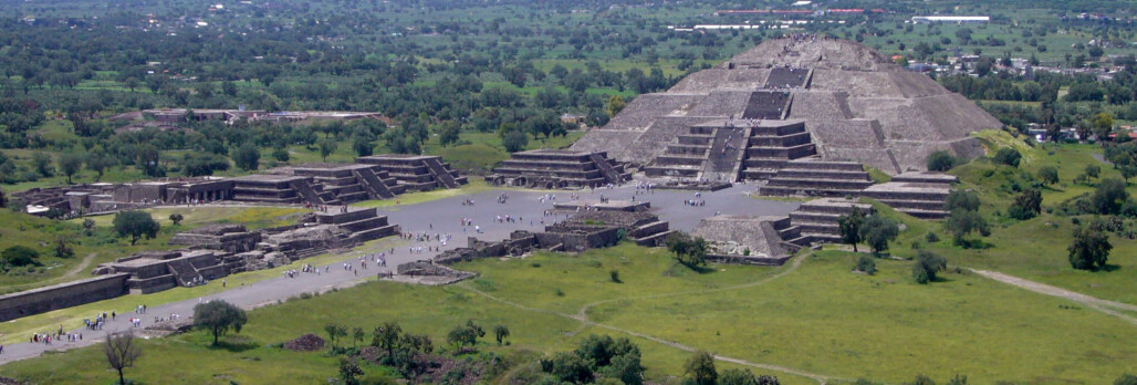
Teotihuacán was the largest city in the New World, construction started early in the 1st millennium AD and continued for 350 years, including the pyramids of the Sun and Moon. In contrast to Oaxaca, few settlements lay outside the city. The city depended on a huge irrigation system fed by springs and seasonal streams within a day’s walk. The much-later Aztecs regarded the city as sacred.

THE CLASSIC PERIOD: TEOTIHUACáN AND ITS NEIGHBORS

During its initial Early Classic rise, Teotihuacán governed a region of about 25,000 sq. km (9653 sq. miles) with roughly 500,000-750,000 inhabitants. But between the 4th and 6th century AD the city’s influence reached far beyond central Mexico. Archaeologists call this the Middle Horizon, which coincides with Teotihuacán’s mature urban phase. With a population of 125,000, many apartment compounds display economic specialization, such as manufacture of obsidian objects, ceramics, grinding stones, shell objects, jewelry, and probably materials that left no traces. These may have been traded in the Great Compound, the city’s principle market.

Sherds of Maya Chicanel pottery appear in the city, and people from western Mexico, the Gulf Coast, and the Valley of Oaxaca visited and lived in special residential enclaves in the city. Some were artisans, others merchants. The so-called Merchants Barrio has the highest concentration of foreign pottery, and round storehouse buildings. Murals at the Tetitla compound show many exotic influences, and it was perhaps used by visiting elites.

The lack of inscriptions means that the ethnicity of the Teotihuacános is unknown, and little is known of its social and political structure. Teotihuacán art is late and does not emphasize royalty, as Classic Maya art does.

Elaborate tombs were not found at Teotihuacán until the 1990s. Under the Pyramid of the Feathered Serpent lay at least one major tomb, with 40 sacrificial victims; many other sacrificed men with weapons and war regalia, along with some women, lay beneath and around the pyramid. Bone isotope signatures reveal that most were from distant places. As they were not captives, this indicates that Teotihuacán’s warriors were recruited from a broad realm.

Since 2000, other rich burials dating to AD 150-350 have been found at the Pyramid of the Moon, perhaps indicating powerful rulers or early kingship, although most excavated individuals were sacrifices. Around AD 250, the Feathered Serpent tomb was publicly looted, stripped of sculpture, and built over, signaling internal troubles. A new regime emphasized more collective and impersonal leadership. Administrative facilities, probably combined with palatial residences, may have been housed in the Ciudadela, perhaps the original royal compound. William Sanders thinks it later shifted to a nearby walled area called the Street of the Dead Complex.

Teotihuacan’s Wider Influence: The Middle Horizon

Stelae at Tikal (Guatemala), 1000 km (620 miles) from Teotihuacán, record that on January 15, AD 378, a lord named Siyaj K’ak arrived. The same day, Tikal’s king died or disappeared. Siyaj K’ak had origins from or connections to Teotihuacán. His name is recorded at other centers, suggesting widespread prestige and influence.

The following year, the son of one of Siyaj K’ak’s entourage was enthroned as Tikal’s king. Fifty years later, Copán’s dynastic founder also arrived as an outsider with connections to Teotihuacán. Long before, around AD 250-300, Teotihuacán Pachuca obsidian was used in burials at Altun Ha (Belize), and Becán’s fortifications from the late Preclassic period may have resulted from trouble with Teotihuacán. Central Mexican iconography became important to Maya architects who incorporated Teotihuacán forms at Acanceh and Chunchucmil (Yucatán).

Great lords were buried with Teotihuacán-style offerings at Kaminaljuyu (Guatemala) which controlled the El Chayal obsidian source supplying the Maya lowlands. Around AD 400-550, a Teotihuacán-style “acropolis” was built there.

Teotihuacán-style pottery and architecture also appeared c. AD 350-400 at Matacapan (Gulf Coast), founded as a Teotihuacán enclave. Pachuca obsidian and imported Teotihuacán vessels (and local imitations) show up at Monte Albán between AD 200 and 600, tomb paintings have Teotihuacán motifs, and carved monuments depict visiting Teotihuacán notables; Teotihuacán may have conquered Monte Albán. Only west Mexico’s Teuchitlan Tradition polities escaped Teotihuacan’s influence.

Around AD 400-450, Alta Vista in northwest Mexico constructed buildings with Teotihuacán architectural elements, along with a new innovation: skull racks displayed sacrificial victims. Teotihuacános may have migrated there. Around AD 850 principal buildings were burned and demolished; scattered human remains indicate violence.

Few archaeologists believe that Teotihuacán had a conquest empire. Quasi-military intrusions as at Tikal, Kaminaljuyu and Becán may reflect displaced or out-of-favor noble factions seeking new areas to establish themselves. Trade and commerce increased interregional connections, perhaps involving professional merchants. Outright colonization, such as in the Gulf Coast seems likely, and cultural emulation may be responsible for the adoption of dress, weapons, political and military imagery, and ritual. Teotihuacán might have been an impressive and mythologized pilgrimage center.

Cholula, Cantona, and the Teuchitlan Cultural Tradition – Independent Polities?

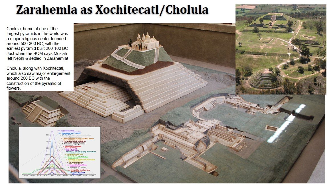
Cholula, with 30,000-40,000 people, was much smaller than Teotihuacan, but its main pyramid became the largest structure in the New World. Architecturally similar to Teotihuacán, in other ways Cholula remained culturally distinct until Spanish conquest. Cantona, established by AD 100, was a Classic center east of Teotihuacán. It lay in badlands, but fertile valleys and obsidian sources were nearby. With workshops, 25 ball courts, plazas and elite residences, 90,000 people may have lived there between AD 600 to 900, as Teotihuacán declined.

Cantona had a distinctive ceramic tradition and had few architectural connections to Teotihuacán. Other than ball courts, it lacks monumental sculpture or symbolism of ritual or political power, but was well situated to dominate highland-Gulf Coast trade, probably in obsidian. Agave, for fiber and the alcoholic drink pulque, grew well there. Cantona may have been established by El Tajin as a seasonal workplace.

Teuchitlan sites also remained distinctive. Between AD 400 and 700, local polities with impressive centers and elaborate shaft tombs were active, each with different ceramic, figurine, and tomb styles. The largest sites contained monumental circular buildings and sets of ball courts. One area had thousands of residential compounds interspersed with obsidian, ceramic, shell, and stone workshops. Around AD 600 a regional metallurgical tradition began to develop. Agricultural drained fields and canals prefigured the chinampas of the Aztec.

The Demise of Teotihuacán

Teotihuacán collapsed amid violence, as deliberate burning and destruction occurred at temples along the Street of the Dead, in the Ciudadela, and elsewhere. No nearby polities were strong enough to conquer, nor are invading foreigners apparent. Internal, factional conflict is more plausible; at least two earlier internal crises occurred: in c. AD 250, the city’s layout was reorganized, and later the Pyramid of the Feathered Serpent was openly looted and despoiled.

It was long thought that collapse occurred around AD 700-750, making it a likely trigger for the collapse of Classic Maya society, but we now know that Teotihuacán’s power peaking c. AD 250-500, with destruction and burning c. AD 500-550 based on magnetic dating. Teotihuacán’s reputation persisted long after, and some 30,000-40,000 people continued to live in a city-state around the old ceremonial core until the 16th century.

EPICLASSIC MESOAMERICA

Monte Albán was too weak to fill the political vacuum created by Teotihuacán’s collapse. Instead, a series of local polities rose during the Epiclassic period, a term only used west of the Isthmus of Tehuantepec and dated there to AD 600-900. Cantona prospered, as did El Tajin on the Gulf Coast, perhaps its trading partner. Closer to Teotihuacán, Cacaxtla developed a palace-like complex protected by a dry moat. Nearby lay a ceremonial complex called Xochitecatl. Together they dominated the Puebla-Tlaxcala Valley between AD 650 and 900. Polychrome murals depict military confrontations between groups with central highland costumes and regalia, others have Maya characteristics. Cholula was probably defeated by Cacaxtla, but still survived as an urban center.

Xochicalco, contemporary with Cacaxtla, had large architectural complexes built on five hills, with earthworks, ramparts, and terraces for defense. Despite poor agricultural conditions, 10,000 to 15,000 people lived on the hillsides, producing crafts and trading. Carvings on the Pyramid of the Plumed Serpent show warriors and toponyms of towns paying tribute to Xochicalco, and stelae record names of kings. Around AD 900 the site was suddenly and violently destroyed.

At the northern boundary of Mesoamerica lies La Quemada, another hilltop center of Epiclassic date. Small but complex, its terraces, residential complexes, temples, palaces, and ball courts, were protected by a defensive wall. Cut, broken, and burned human bones indicate display of human skeletons as war trophies.

None of Teothihuacan’s successor states was strong enough to reestablish Classic-type order and prosperity. Only Tula, founded after AD 700 some 80 km (50 miles) northwest of Teothihuacan came close.

THE CLASSIC MAYA

The early sophistication at Nakbé, El Mirador, and Tikal took hold in the southern lowlands after a widespread Late Preclassic crisis. Royal and ritual texts inscribed on altars and stelae chart a network of interacting kingdoms; Yucatán developed in somewhat different ways.

Early Classic (AD 250-600) inscriptions and less abundant Late Classic texts are retrospective, describing earlier times. By the early 6th century AD, Tikal led a coalition at odds with an alliance led by Calakmul. The period is called the “Hiatus” due to related population decline and political crisis. Piedras Negras and Tikal did not raise royal monuments for much of the 6th and 7th centuries AD. Caracol and Copán continued to prosper, so crisis was not universal. Maya society was reorganized; monuments after AD 600 presented kings in highly personalized ways, with new titles, and increasingly emphasized warfare.

Late Classic Maya society, between AD 700 and 800, is documented through 15,000 texts. Combined with architecture and art, rulers and lords, gods and ancestors, dynasties, polities, toponyms, births, deaths, accessions, wars, rituals, and alliances are well known. The linear Long Count, used everywhere, gives chronological context.

Unfortunately, Maya inscriptions are not ubiquitous, are mostly late, and say little about the lives of common people. The Late Classic phase began as Teotihuacán declined, which did not disrupt Maya culture.

Kingdoms and Capitals The southern Maya lowlands were never politically unified, and during Late Classic times 45-50 kingdoms are indicated by emblem glyphs. These kingdoms varied greatly in age, size, material culture, and political and social arrangements. Yet shared Maya traditions united them, reinforced by trade, alliances, intermarriage, rituals and religious beliefs.

Each kingdom focused on a central precinct dominated by large masonry pyramid-temples, the palatial residences of kings and lords, public plazas with altars and stelae, and ball courts. Over time, elaborate tombs were built, such as the tomb of K’inich Janaab’ Pakal, the 7th-century king of Palenque.

Radiating out from the royal and ceremonial cores were commoner households, dispersed and gradually merging with rural households that formed 80-99 percent of the population, different from the highly concentrated urbanism at Teotihuacán and Monte Albán. Maya centers, with some exceptions, often lacked urban multi-functionality, and were mainly courtly and ritual places. Some kings occasionally dominated lesser ones through alliance, conquest, or patronage. Polities of hundreds of thousands of people may have been fragilely patched together by superpowers such as Tikal or Calakmul.

Maya Society Maya social and political organization was hierarchical and centered on the royal families who bore the ancient ajaw title. Maya kings were sacrosanct, custodians of mysterious “god bundles,” and had sacred duties, in which they impersonated gods, ensured cosmic stability and agricultural fertility. Some, like Pakal, were regarded as divine and deceased royal ancestors exerted powerful influences over the living.

Succession was through the royal patriline, but women could serve as regents or occasionally as queens in their own right. Kings were expected to be warriors; monuments describe capture and sacrifice of enemies. Other royal males were sometimes artisans who made stelae and precious objects, and probably oversaw writing and calendrical lore.

Exalted lords and officials (some royal relatives) had bestowed or inherited titles such as sajal or aj k’uhuun: ‘subordinate ruler’ and royal ‘provisioner.’ Women sometimes bore these titles as well. Living in palatial residences, elites attended court and served governmental and ritual functions.

Commoners, the bulk of whom were farmers, paid taxes in kind or labor, probably served in war, and lived in modest households, some practicing swidden agriculture, others more intensive systems with terraces and drained fields.

Warfare was constant, in contrast to an old theory that the Maya were a uniquely peaceful civilization. War was waged for territorial expansion, sacrificial victims, tribute, vengeance, status, and eliminating enemies. No polity or coalition was powerful enough to unite the Maya lowlands.

By the late 8th century AD populations reached unprecedented densities, and spectacular building projects were initiated. Underlying stresses soon led to a collapse of Maya civilization.

POSTCLASSIC MESOAMERICA

Before radiocarbon dating, Maya Long Counts appeared to indicate crisis between AD 800 and 1000, extrapolated to provide dates for a “Mesoamerican Postclassic” when societies were supposedly unsophisticated, warlike and “decadent.” We now know this is erroneous. There was no sudden florescence and decline across Mesoamerica. Teotihuacán and Monte Albán lost power centuries before the Maya, and Postclassic societies were extraordinary civilizations. Oral histories, indigenous books, and Europeans descriptions provide excellent documentation.

The Rise of the Toltecs

The mythic Tollan of the Aztecs was inhabited by the Toltecs, accomplished artisans and agriculturalists, wise in medicine and calendrical lore. They supposedly lived harmoniously under their ruler Ce Acatl Topiltzin Quetzalcoatl. Their principal god, also called Quetzalcoatl, required only butterflies as sacrifice. Tollan finally fell, the myths said, when Quetzalcoatl and his followers were tricked by evil servants of the god Tezcatlipoca, fleeing to distant lands in the direction of the rising sun.

The real Tollan, Tula, lies just outside the Basin of Mexico northwest of Teotihuacán, where rivers provide irrigation. In Classic times Teotihuacán colonists there produced lime for plaster. Around AD 700, civic structures appeared and artifacts indicate that Tula was founded by migrating Tolteca-Chichimeca peoples. Tula matured into a huge city between AD 900 and 1200, with a population of 60,000 that fused central Mexican, Gulf Coast, and northern influences. Nahuatl was probably spoken there.

City households were multi-roomed adobe structures around a courtyard, housing several nuclear families. As at Teotihuacán, there were many workshops. Tula was supported by outlying rural communities.

Pyramids, ball courts, and colonnaded halls, showing architectural similarities with Teotihuacán, were decorated with jaguars and deities, and supporting pillars carved as warrior figures, each named by undeciphered glyphs resembling later Aztec writing. During Tula’s hegemony, trade with the Pacific, the Gulf of Mexico, Casas Grandes in North American Mexico, and even Central America occurred. Toltec trading colonies have been found as far south as El Salvador.

Tula dominated sizable territories; the whole Basin of Mexico, and possibly tributary client states in northern Mesoamerica. Tula’s principal rival was probably Cholula. Sometime around AD 1150-1200 Tula violently collapsed, indicated by burning and looting of principle buildings. Many people continued to live in the region and a reoccupied urban zone was later subject to the Aztecs.

THE POSTCLASSIC MAYA

The Puuc Florescence. Maya polities in the northern Yucatán weathered and even benefited from the southern Maya collapse. Early in the 8th century AD, population expansion occurred in the fertile Puuc region and new, sophisticated water storage technology combated aridity. Sayil, Kabah, Labna, and Uxmal display distinctive Puuc architecture: columns and complicated mosaic sculptures of gods, humans, and geometric designs, exemplified at the House of the Governor and the Nunnery at Uxmal. By AD 875-900, Uxmal gained political ascendancy.

Puuc prosperity was short-lived; the centers collapsed, their hinterlands heavily depopulated c. AD 1000 or a little later. Migrants to the northern Yucatán plains created Puuc-type settlements where the next regional power soon appeared.

Chichén Itzá and Mayapan. Chichén Itzá was the greatest Postclassic capital, rising during the 8th century AD in northern Yucatán near a huge cenote that became a pilgrimage center. Features of the site are the Castillo Pyramid, the Monjas Palace, and a gigantic ball court. Many buildings show Puuc or Toltec architectural affinities. Indigenous histories say that the Itzá founders were succeeded by Mexican migrants led by Kukulkan, meaning “Feathered Serpent” in Maya. Inevitably, this became associated with the myth of Quetzalcoatl’s expulsion from Tula.

Chichén Itzá’s inscriptions and dates are confined to the 9th century AD. Warrior and sacrifice imagery abounds, related to conflicts with other Puuc centers. After AD 900, Chichén Itzá eclipsed rival Coba, and Mexican influences proliferated. For several centuries it was a state capital and mercantile emporium trading in salt and other commodities. Around AD 1200 or 1250, Chichén Itzá declined although remaining a pilgrimage center even after the Spaniards arrived; one Itzá faction fled south and founded the last of the Maya kingdoms.

Power shifted to Mayapan, founded by the Cocom family. Its main buildings are small and shabby compared to Chichén Itzá but over 4000 residences (perhaps 12,000 people) were crowded within, including many elites and their retainers. Conflicting Maya accounts say Mayapan fell c. AD 1441, amid drought, famine, and a rebellion of Xiu lords against the Cocom lineage. Burning is evident, and Mayapan was abandoned before the Spaniards arrived.

MESOAMERICA DISCOVERED: WHAT THE SPANIARDS FOUND

In 1519 Hernan Cortés sailed with a small fleet to Yucatán after two previous expeditions reported impressive native cultures there. Best known for conquest of the Aztec, Cortés also left accounts of the 16th-century Maya.

The Maya of the Early 16th Century

After Chichén Itzá and Mayapan fell, hundreds of small polities emerged, ruled by hereditary leaders called batabs, each with a few thousand subjects. Fragile alliances united batabs of the same lineage, but war was common among and within batabships, as noble families (i.e. Xiu and Cocom) were traditional enemies. Some petty kingdoms may have ruled 60,000 people.

Despite lack of integration, these societies were complex, and retained Classic patterns, with large towns, temple pyramids, public plazas, elaborate houses, rituals, books, and calendars. Nobles were supported by taxes and engaged in long-distance trade. Most people grew maize, fished, or produced salt. Slaves were war captives or debtors. After skirmishing with the Maya, Cortés moved on to confront the Aztecs.

The Aztecs and the Late Horizon: History and Myth

16th-century people believed their ancestors had migrated to the Basin of Mexico from the northern fringes of Mesoamerica, beginning when Tula collapsed, or earlier, linked to climatic change and political instability. Among those people were Aztec ancestors, who were Nahuatl speakers called Chichimec. Some were described as savage hunter-gatherers, others as farmers who played the ball game and built temples, and others were sophisticated refugees from the Toltec kingdom. Some archaeologists think these wanderings first introduced Nahua speakers into the Basin of Mexico. Others think migration accounts were “reconstructed history,” made up later to justify events. If glyphs recently detected at Teotihuacán turn out be Nahuatl, this will be strengthened.

None would have called themselves Aztecs; they called themselves Mexica-Tenochca (the founders of Tenochtitlán), Acolhua, Tepaneca, or Chalca. Others came from a mythical homeland called Aztlan (thus the label “Aztecs”). One band, the Mexica, eventually were driven as despised refugees (or led by their god) onto small islands in Lake Texcoco, surrounded by enemy polities. Here, in AD 1325 the Mexica founded their capital, Tenochtitlán.

At the end of the 14th century, several dozen warring city-states lay in the Basin of Mexico. The Mexica-Tenochca enlisted as mercenaries with the powerful Tepanecs, receiving a share of tribute. They elected a king, who married into an exalted dynasty descended from the Toltecs. In response to a falling out in AD 1428, the Mexica, aided by the Texcoco and Tlacopan states, overthrew the Tepanec. The Mexica king Itzcoatl and his followers became dominant and powerful, promoting the Mexica tribal god. At this juncture, by their own account, they burned their ancient books and proceeded to write “true” history, setting the stage for the empire under the Triple Alliance of Tenochtitlán, Texcoco, and Tlacopan for 91 years. This short interval is called the Late Horizon.

The Aztec Empire in 1519 By 1519 the Aztec empire dominated 400 previously independent polities over an area of about 200,000 sq. km (77,220 sq. miles), including the Gulf Coast, the Valley of Oaxaca, parts of western Mexico, and the Pacific coast of Guatemala, with subjects numbering between 6 and 10 million people, 1 to 1.5 million in the Basin of Mexico. Terracing, irrigation systems, and artificially drained fields made it a productive agrarian region.

The empire was assembled through intimidation, alliance, and conquest. Conquered polities were grouped into 38 tributary provinces, from which tribute of all kinds flowed, enriching Tenochtitlan’s rulers, who dominated the Triple Alliance. Other provinces joined the empire as military allies, paying only nominal tribute. Such allies were necessary as moving and feeding large armies without effective transport was difficult, and powerful enemies remained.

The Aztec’s greatest enemies were the Tarascans of western Mexico, who by 1519 controlled 1,500,000 people from their capital of Tzintzuntzan on the shores of Lake Patzcuaro, a small but highly centralized state. Tarascan warriors inflicted heavy defeats on Aztec armies.

The Tlaxcallan confederation, east of the Basin of Mexico, were culturally similar to the Aztecs but retained their independence, ultimately supporting the Spaniards.

Complaisant local rulers were left in place, and their offspring married into the royal families of Tenochtitlán, Texcoco, and Tlacopan. Sometimes local dynasties were replaced with royal governors, their lands absorbed by the rulers. Elsewhere, the Aztecs ruled cheaply through intimidation and tax collection. Yet in some 20 places (i.e. the Valley of Oaxaca and the Tarascan frontier), imperial governors and garrisons were necessary. Punitive measures were sometimes used locally and core populations were sometimes resettled in frontier posts.

Aztec Society. Each city-state (altepetl) in the Basin of Mexico shared language, diet, technology, religion, customs, and political organization. One or more hereditary king (tlatoani) ruled each altepetl. Kings, their families, and nobles (collectively called pipiltin), benefited from the tribute of empire. Polygyny increased the noble class, necessitating further resources and conquests. Nobles received land as a reward for service. After special education, the pipiltin monopolized political, religious and military offices, and participated in court life in the capital.

Commoners paid taxes to their own tlatoani and his overlord. Most were farmers or artisans, living in neighborhoods with their own leaders, schools, and temples, contributing corvée labor and serving in the army. Commoner warriors occasionally achieved quasi-noble rank. Talented artisans also had high prestige. The pochteca, or professional merchants, led trading expeditions, becoming rich and enjoying upward social mobility.

The mayeque were tied to the estates of kings and nobles, paying taxes only to their immediate lords. Many, originally free, became serfs through conquest. At the bottom were the tlacotin, who owed service through debt or criminal acts. They could own property and buy freedom, and their children were born free. They were not poorly treated, though malcontents could be sold or sacrificed.

The Spanish Conquest

In 1519, the Mexica Emperor Motecezuma II was attempting to annex the stratified and warlike highland Maya, when a new and unexpected threat appeared in the form of Hernan Cortés and his 500 men. By coincidence, they arrived on the day that Aztec diviners prophesied the return of Quetzalcoatl. Cortés marched inland seeking the riches he had heard of. The Tlaxcallans initially resisted, but realized the newcomers could be used against their hated Aztec enemies. Accompanied by indigenous allies, Cortés entered Tenochtitlán, where Motecezuma received them, but was soon placed under Spanish “house arrest.”

Eventually, Motecezuma was killed during fighting in 1520, after Spanish desecration of the main temple. The allies of Tenochtitlán fell away, most damagingly, Texcoco, a former imperial partner. After months of fierce fighting, the Spaniards destroyed Tenochtitlán in 1521.

Most of Mesoamerica was in Spanish hands by 1550, but the Itzá Maya held out for another 150 years until 1697.

Subsistence species
maize
beans
agave
amaranth
chia
blue-green algae
deer, rabbits, quail

Languages
Nahua
Mixe-Zoque
Mayan
Mixtec
Zapotec

Ancient/Historic people
Hernan Cortés
Bone Rabbit
Siyaj K’ak
K’inich Janaab’ Pakal
Ce Acatl Topiltzin Quetzalcoatl
Kukulkan
Cocom lineage
Xiu lineage
Itzcoatl
Motecezuma II

Deities
Quetzalcoatl
Tezcatlipoca

Periods, Phases, Horizons
Preclassic (Formative) 2500 BC-AD 250
Early Preclassic period 2500-1000 BC
Middle Preclassic period 1000-400 BC
Late Preclassic period 400 BC-AD 250
Early Classic period AD 250-600
Late Classic period AD 600-800
Terminal Classic period AD 800-1000
Early Postclassic period AD 1000-1250
Late Postclassic period AD 1250-1519
Olmec 1200-400 BC
Early Horizon
Epi-Olmec period
Teotihuacán
Middle Horizon
Western Mexican polities 1500 BC- AD 400 (Colima, Nayarit, Jalisco)
Cholula, Cantona, and Teuchtitlan

Cultures
Mixtec
Zapotec
Maya
Puuc culture
Early Classic “Hiatus”
Toltec
Chichimec
Mexica-Tenochca
Acolhua
Tepaneca
Chalca
Aztlan
Late Horizon
Aztec
State of Texcoco
State of Tlacopan
Tarascans
Tlaxcallan confederation
Quiché and Cakchiquel Maya kingdoms
Itzá Maya of northern Guatemala

Important Sites
San Jose Mogote (Oaxaca)
Chalcatzingo (Central Mexican Highlands)
Tres Zapotes (Mexican Gulf Coast)
La Venta (Mexican Gulf Coast)
San Lorenzo (Mexican Gulf Coast)
El Portón (Guatemala)
Monte Albán (Oaxaca)
Teotihuacán (Basin of Mexico)
Kaminaljuyu (Guatemala)
Tikal (Guatemala)
Nakbé (Guatemala)
El Mirador (Guatemala)
Lamanai (Belize)
Cerros (Belize)
Cuello (Belize)
Becán (Campeche)
Dainzu (Oaxaca)
Cuicuilco (Basin of Mexico)
Teotihuacán (Teotihuacán Valley, Basin of Mexico)
Tula (Basin of Mexico)
Copán (Southern Lowlands)
El Peru (Guatemala)
Altun Ha (Belize)
Acanceh (Yucatán)
Chunchucmil (Yucatán)
Matacapan (Tuxtla Mountains, Gulf Coast)
Alta Vista (northwest Mexico)
El Tajin (Gulf Coast)
Cantona (Central Mexican Highlands)
Cholula (Central Mexican Highlands)
Cacaxtla (Central Mexican Highlands)
Xochitecatl (Central Mexican Highlands)
Xochicalco (Central Mexican Highlands)
La Quemada (northern Mexico)
Calakmul (Southern Lowlands)
Piedras Negras (Southern Lowlands)
Caracol (Southern Lowlands)
Palenque (Southern Lowlands)
Quirigua (Southern Lowlands)
Yaxchilan (Southern Lowlands)
Bonampak (Southern Lowlands)
Tula (fringe of the Basin of Mexico)
Casas Grandes (northern Mexico)
Sayil (northern Yucatán)
Kabah (northern Yucatán)
Labna (northern Yucatán)
Uxmal (northern Yucatán)
Chichén Itzá (northern Yucatán plain)
Coba (northeastern Yucatán)
Mayapan (northern Yucatán plain)
Tenochtitlán (Basin of Mexico)
State of Texcoco (Basin of Mexico)
State of Tlacopan (Basin of Mexico)
Tzintzuntzan (Patzcuaro Basin)
Nojpeten (Guatamala)

Artifacts, features, buildings, structures
Olmec
Red Palace
El Manati
colossal stone heads
buried serpentine slab patterns, stelae
pyrite mirrors, obsidian
blue-green jade carvings
huge rectangular thrones
basalt column tombs

Maya
red-slipped Chicanel pottery
the Hauberg Stele (AD 197)
defensive walls at El Mirador
earthworks at Becán
El Chayal obsidian source
urban central ceremonial/elite precinct
“god bundles.”
Puuc architectural mosaic sculptures of gods, humans, and geometric
the House of the Governor and the Nunnery (Uxmal)
Chichen Itza – cenote, the Castillo Pyramid, the Monjas Palace, Puuc and Toltec architectural affinities

Zapotec
Danzante warrior frieze
“conquest slabs” in Building J
skull racks

Teotihuacán
Street of the Dead
Pyramids of the Sun and the Moon
apartment compounds
Great Compound
Merchants Barrio
Tetitla compound
Pyramid of the Feathered Serpent
Ciudadela
Pachuca obsidian
skull racks

Central Mexican polities
Teuchtitlan shaft tombs, monumental circular buildings
Xochitecatl polychrome murals
Xochicalco – Pyramid of the Plumed Serpent

Toltec
warrior figure pillars

Book of Mormon Geography

Book of Mormon Geography Found- Mexican Highland Continental Model (summary)

by Lance Weaver

Main complex of Teotihuacan. Built up in response to Gadianton aggression circa 17 AD when Lachoneus moved the capital from Cholula (Zarahemla), gathering the Nephite nation from the surrounding lands to create the largest and most impressive multicultural urbanization endeavor the North American continent had ever known.
Monte Alban Temple Complex. Circa 550 BC, Nephi led the natives of the Oaxaca Valley to create one of the most impressive temple complexes ever attempted, by shearing off the top of a 1000 foot hill they created a new-world ‘Mount Zion’. Patterned after Jerusalem with large promenades, tombs, massive side-walls and several large east facing two room-two columned temples placed before large alters and basins.

Outline

This article is only a very rough draft summary of a much larger book I’m writing which I don’t expect to finish for at least a decade. The basic outline of this model came to my brother and I in a series of dreams/morning visions and research about 20 years ago shortly after returning from our LDS missions. Since those initial experiences a continual stream of incredibly insights and ideas have come to me which have helped me unravel and understand parts of this model which not even I believed early on. Since those initial experiences I’ve been through the up and downs of life and have even done my best to lose faith and run from the calling I believe I received to reveal the correct Book of Mormon geographic model and help convince the Natives Americans of Oklahoma, the US Southwest, and West/South-central Mexico of the truth of their ancestors. Ultimately this convincing will be done the same way it was for me–through dreams and visions where ancestors visit their progeny and pass onto them the riches of their heritage through spiritual means.

And it shall come to pass in the last days, saith God, I will pour out of my Spirit upon all flesh: and your sons and your daughters shall prophesy, and your young men shall see visions, and your old men shall dream dreams (Acts 2:17)
For I would not, brethren, that ye should be ignorant of this mystery, lest ye should be wise in your own conceits; that blindness in part is happened to Israel, until the fulness of the Gentiles be come in. (Romans 11:25)
But they shall be gathered again; but they shall remain until the times of the Gentiles be fulfilled. And in that day shall be heard of wars and rumors of wars, and the whole earth shall be in commotion, and men’s hearts shall fail them, and they shall say that Christ delayeth his coming until the end of the earth. (D&C 45:25–26)


  1. Introduction
    1. Summery of what sets this model apart.
  2. Internal Model. (compare a bit to heartland and Mesoamerica)
  3. The Continental Model of Joseph Smith
  4. The writings of Ixtlilxochitl
  5. The Caractors document.
  6. The Narrow Neck.
  7. Arrival of the Jaredites (put after Nephites?)
  8. Omer and his household
  9. Post Dearth Jaredite culture
  10. Colonial arrivals (arrival writing, pyramids)
  11. Olmec or Zapotec as the mother culture? (Emergence of Zapotec hieroglyphic writing and calendrics to Mesoamerica)
  12. The move the Zarahemla
  13. The Seven Tribes of Early athors (find quotes) Matching BOM seven tribes.
  14. Zeniff and the City of Nephi
    1. Towers AND temple matching so well Noah’s building project.
  15. The emergence of the Zapotec Military State. (skull racks & warefare)
  16. Captain Moroni: Fortifying the Balsas Basin & Mexican Highland
    1. Mixtec sites move to fortresses & garrisons on East Coast.
  17. The people of Ammon in Jershon, linguistics matching matriarchal society of…
    1. Could the major Burial of Chiape de Corzo be Lamoni’s father?
  18. Lachoneous and the Founding of Teotihuacan
  19. Cataclysms at the coming of Christ
    1. Ixtextla records. Known volcanism and destruction of towns. PROBLEMS WITH RADIOCARBON DATING. (see txt file ‘anomalous old c14 dates in archaeology papers folder in drive)
    2. Tetimpa, Cuicuilco and Cholula were covered with volcanic ash like Pompaii right near the time of Christ. Zarahemla of Sorenson or Usamacinta models are 100 miles or more from the single active volcanic center. [make map of mexico’s active volcanoes]
  20. The tents, houses of cement (adobe) and shipping of timber in the desolate southwest.
  21. The golden or ‘Classic’ age of Zion
  22. Was Mormon Anasazi? A case for time discrepancies in 4rth Nephi
  23. The land of Desolation (matching accounts of Aztlan so well)
  24. The destruction of American Civilization
Book of Mormon Geography Continental Model


.

Introduction

This article presents the new Mexican Highland-continental model Book of Mormon Geographic correlation. With this model, essentially every culture the texts mentions end up being a major culture found by modern archaeologists. In fact, essentially all the largest North American prehistoric cultures are represented in this model of the Book of Mormon text. This unique continental model also correlates incredibly closely to the beliefs of Joseph Smith and other early LDS prophetic figures.

Far from sticking the Book of Mormon location into a small Mesoamerican or Heartland corner, our model correlates the texts most mentioned cities with the most influential Mesoamerican archaeological ruins. Zarahemla and the Nephites are correlated with arguably the largest cities and most dominate, powerful prehistoric culture on the continent — Teotihuacan/Cholula and the Mexican Highland/Balsas Basin culture. The Lamanites are correlated with what was likely the most sophisticated and populous culture in American prehistory — the Maya. The City of Nephi with its towers, priest cult and expensive public works correlates with the great Zapotec fortress of Monte Alban, which sat between the Maya (Lamanite) and Highland (Nephite) cultures. The River Sidon matches with what many consider Mexico’s most economically important & strategic water way– the Rio Balsas.

The book of Mormon’s ‘Land Northward’ stretches from the rock & cement great-houses of the ancient Puebloan peoples in the desert southwest, where Joseph Smith taught “the Nephites lost their power”, all the way through Mississippian and Hopewell peoples of the Eastern United States.

The early Jaredites end up largely corresponding to not only the first inhabitants on the continent but also the only North American culture that archaeologists have found to have coexisted with elephants and other extinct mega-fauna (Paleoindian, Clovis & Folsom cultures). They expanded to cover both Northern America and Mexico instead of just a part of the Isthmus of Tehuantepec (proto-Adena as well as Olmec & all other archaic to early formative/woodland groups). And the destruction of the Nephite culture described in the text, corresponds to the well-known collapse of essentially half the major cultures on the North American continent between the radiocarbon dates of 1050-1150 AD from Tula to West Mexico and the Anasazi/Ancient Puebloans as well as Cahokia and Cumorah (peoples of the ‘Land Northward).

Truly all the main events of the Book of Mormon have been found by archaeologists and correspond with the most notable events in North American prehistory. However, most LDS scholars have overlooked these amazing correlations because of hang-ups involving their mistaken narrow neck and radiocarbon/timeline issues which we explain in detail.


The Failure of All Other Models

LDS scholars have tried to find a convincing correlation between the Book of Mormon narrative and archaeological evidence for 150 years and yet are still squarely split between three predominate models. Why? Simply put, there is no perfect match to the geography described in the Book of Mormon. All models contain a number of substantial problems between the text and available archaeological evidence.

In my model I believe this failure has been the result of most models being primarily based on two things that ancients were typically VERY bad at. A solid understanding of the geography of sparsely populated regions and shorelines such as the Book of Mormon narrow neck — and keeping highly accurate long-term calendar systems. Just a cursory look at maps made before the revolutionary charting technology of the Renaissance age helps one to understand how differently ancient people saw the world. Cultures without pervasive sea-going capabilities and nautical instruments simply could not accurately map many shorelines. Calendars and succession chronologies also, were typically anchored to partially mythic or random historical events such as a king’s assertion to the throne or a natural disaster—and often historical texts and genealogies contained large gaps or false interpolations between these events. Modern Mormon scholars have simply expected too much of the past prophet/historians who compiled the Book of Mormon.

REWRITE THIS. PART OF IT IS MISUNDERSTANDING PART MIGHT BE POOR WORDING BECAUSE OF THIS ISSUE. In a following chapter we provide overwhelming evidence that most early geographers had rudimentary knowledge of shorelines in the places where few people ventured. We suggest that because of the impassible nature of the Great Salado Basin & Chihuahua Desert, Mormon similarly believed the East & West Sierra Madre Mountain Ranges to be the same single range. Mistaking the narrow east & west Mexico travel corridors for another ‘narrow neck of land’ or “narrow pass” like many of the others found in Central America.

We also devote a chapter to explaining why the radiocarbon techniques used to date the North American post-classic cultural collapses do not seem to correspond with the Book of Mormon dates. Even though the evidence of cultures, populations, settlement patterns, war, cannibalism, cultural destruction and abandonment and desolation stretching all the way from the Toltec and Maya through the Anasazi lands and Cahokia seem to match amazingly with what is described in the book of Mormon text. For this discrepancy we give two possible explanations. One being skewed radiocarbon dates caused by a type of marine reservoir effect of excess carbon 14 introduced by a massive comet and CME hitting the Pacific Ocean at the time of Christ (much like the similar but smaller documented 774 AD event). And the other being a rather convincing argument that there were actually two large comet impacts in the Pacific Ocean which corresponded with two separate Quetzalcoatl figures in the Nephite (and Aztec) annals. One at the death of Christ and one at 774 AD which combined with a few other calendrical issues, caused Mormon to mistakenly believe he lived around 400 years after the death of Christ, when in fact he actually lived 400 years after 774 AD and Lord Quetzalcoatl the ruler of _____.

Our model is different than most others in that it focuses on correlating cultures, events and actual archaeological cities instead of focusing so much on radiocarbon dates and the narrow neck. We also show the significance of considering the Book of Mormon a ‘channeling’ instead of a ‘translation’. Channeling, or the act or practice of a mystic somehow ‘seeing’ events across space and time and/or serving as a medium through which an angel or spirit purportedly communicates with living persons was very common during the Second Great awakening, and far better explains the anachronisms and issues which exist in the Book of Mormon text. By looking at the text as a more fluid product of visionary ability instead of a literal translation, amazing correlations become apparent. Book of Mormon events begin to align with all the major cultural movements & conflicts found in North American prehistory, and a .

Book of Mormon Geography
Illustration depicting the actual geography of North America versus what the ancient authors of the Book of Mormon may have thought the geography looked like

Illustration depicting the actual geography of North America versus what the ancient authors of the Book of Mormon may have thought the geography looked like. {Change defense line to names of cultures/bom peoples with dates of existence.}

The Continental Model of Joseph Smith

From the available documented evidence, it is apparent Joseph held a continental view of Book of Mormon Geography.  Quotes by Joseph Smith or statements attributed to him point to a belief in four major areas of Book of Mormon happenings.

  • He believed the Lehites to have landed in South America (refs)
  • He believed them to have travelled to Central America to settle (with cities like Zarahemla being there). (refs)
  • He believed them to have ‘lost their power’ (i.e. the Land Desolation) in the U.S. Southwest. (refs)
  • He believed Cumorah and the final battle to be in New York, and much of North America to be the Book of Mormon ‘Land Northward’. (refs)

-quote of landing in Chile or a bit south of the isthmus of Darian

-quote of Land of Lehi (lands of Nephi, Zarahemla and Bountiful) was in Mesoamerica

-quote of Desolation being the Desert Southwest (ancient Puebloan cultures)

-quote of Cumorah and final battle being in New York.

Use my article AND the farms ones.  http://mormonuniversalism.com/449/joseph-smith-quotes-on-book-of-mormon-geography/, https://www.fairmormon.org/answers/Book_of_Mormon/Geography/Statements/Nineteenth_century/Joseph_Smith%27s_lifetime_1829-1840, https://www.fairmormon.org/blog/2010/04/02/book-of-mormon-geography-in-joseph-smiths-day


An Internal Model

Go through and do a one-page summary of needed internal model aspects.  Get from intro to my already done internal model web article.

[pic of internal model]

The Narrow Neck

A study of ancient maps and geographies suggests that modern LDS Scholars have expected too much from ancient Book of Mormon authors by supposing pre-Columbian cultures had a modern understanding of continental geography and shorelines. Indeed, although many ancients understood well the spatial relationships for populated places, or places they had been, the understanding of uninhabited wildernesses and continental shorelines seems to have been very poor among cultures without widespread use of boats containing some type of nautical navigation technology.

Our model proposes that much like Sabastian Munster’s early map of the New World, Book of Mormon authors seemed to have thought there to be another ‘narrow neck’ between the narrow coastal ‘passes’ of Northern Mexico. A misunderstanding likely caused by a belief that the Eastern and Western Sierra Madre mountain ranges were one and the same range. An easy mistake to make given their lack of travel through the nearly impenetrable and uninhabited Mapimi Basin of the Chihuahua Desert. Indeed historical texts show that essentially ALL travel & trade instead, occurred along the ‘narrow passes’ between the coasts and the steep mountain ranges, with only a few sparsely inhabited mining communities existing in the Deserts of the northern interior.

Note that Cabeza De Vaca, after being marooned in the New World and living with the Natives for years in regions all the way from Florida to West Mexico, still though late in life that northern California somehow shared the continent with Asia. He describes the mental geography he had created in his mind after living with the natives thusly.

These people [Southwest Natives] … must come from that part of Greater India, the coast of which lies to the west of this country, for they could have come down from that country, crossing the mountain chains and following down the river… As they multiplied, they have kept on making settlements until they lost the river when it buried itself underground, its course being in the direction of Florida. It [the Rio Grande] comes down from the northeast, where they [Coronado’s army] could certainly have found signs of villages. He [Coronado] preferred, however, to follow the reports of the Turk, but it would have been better to cross the mountains where this river rises. I believe they would have found traces of riches and would have reached the lands from which these people started, which from its location is on the edge of Greater India, although the region is neither known nor understood, because from the trend of the coast it appears that the land between Norway and China is very far up [in the North/Arctic]. The country from sea to sea is very wide, judging from the location of both coasts, as well as from what Captain Villalobos discovered when he went in search of China by the sea to the west, and from what has been discovered on the North Sea concerning the trend of the coast of Florida toward the Bacallaos, up toward Norway.

(The Narrative of Alvara Nunuz Cabeza de Vaca. Ch 6. v. 3)
[Pictures of the coastal passes from my 3d map with exaggeration.]

REWRITE THIS A BIT…  The problem, of course, is that these overwhelmingly obvious correlations do not work with Mormon’s ‘narrow neck’, which is said to be north of Zarahemla and Bountiful. (As well as a few radiocarbon dating issues we cover in another section). Because of this, most serious LDS scholars have looked south of the isthmus of Teohuantepec, isthmus of Guatemala, or isthmus of Panama. A correlation which forces one to ignore EVERY major culture in North America apart from the Maya (the Lamanite core in our model). But of course, because essentially ALL the greatest Mayan cities are east of the possible candidates for the River Sidon, as well as significant issues with Moroni’s ‘east sea cities’ (ref), these models must throw out even the largest and most influential Mayan cities from any possible correlation with the Book of Mormon. With our continental model, essentially EVERY significant ancient culture in the North American continent, as well as their largest cities, are part of the Book of Mormon narrative. From the Maya to the Zapotec, Huestec to Mixtec, Teotihuacan and the Mexican Highland to the Toltec and Chichimec to the Ancient Puebloan/Anasazi to the Hopewell. The list goes on and on, of overwhelming correlations between the Book of Mormon text and archaeological ruins, geographic relationships, language relationships, Native American mythologies, settlement patters and more.

Arrival of the Jaredites

Start by talking about how it’s a channeling of a channeling.

The Book of Mormon narrative explains that the Jaredite civilization was the first culture to inhabit North America and the only to coexist with elephants and other megafauna early in their history. (Ether 9:19, Note that for the early Jaredites, these megafauna were ‘especially useful for the food of man’.) It further states that a great dearth or climatological shift caused massive fauna migrations which the people followed, hunting them to extinction. (Ether 9:30,34)

Shouldn’t it be obvious that the only plausible archaeological correlation for the pre-dearth Jaredites is with the North American Paleo-Indians? (C14 dated from between 14,000BC to 7000BC) These were the first inhabitants of North America, and are the only North American cultures to interact with elephants (Mammoth and Mastodon). There are also many other correlations between these cultures but none have seen the similarities because of the difference between carbon dates obtained for these cultures and the dates inferred from the scriptural record.

The cultural center for two of the most notable Paleo-Indian peoples (the Clovis & Folsom) are located in the North American Southwest, which as both the Book of Mormon and our model show, matches with the Nephite land of Desolation.

Although modern scientific consensus is that these groups migrated from Asia to North America across the bearing straights, we believe that the Book of Mormon account of ship travel is equally plausible (given the 40,000 BC in-habitation of Australia). Diverse groups of ‘Jaredites’ spread out to cover North & South America, and we propose also migrating back into Siberia, Asia and parts of Europe.

We also suggest that the Jaredite account, like the Book of Mormon itself, was ‘channeled’ by the ancient author Alma from some ancient record which acted as a talisman or prop. In doing so, the ancient author projected his own biases and beliefs on the Jaredite record in the same way Joseph would have later done with the ‘translation’ (channeling) of the Book of Mormon.

Map of known ancient migrations, overlaid with possible path of Jaredite migration.

Omer and the Bull Brook Complex

As the early Book of Mormon ‘pre-dearth’ period in American prehistory was coming to a close, a small group of families left the core area and settled ‘by the seashore’ directly east of the hill Cumorah (Ether 9:1–13). The group of sites, in and around northeastern Massachusetts, are called the Bull Brook Complex by archaeologists. Clovis points found at several of the sites tie it to the Southwest.

Building on excavations by D.S. Byers in the mid-50s, archaeological societies in the Northeast have pieced together the history of the Bull Brook Complex. Their findings and subsequent analysis have shown the interactions of a system of organized, interdependent groups with specialized work force networks. It is recognized as containing the highest level of social structure in America at that time, which would be expected in a ‘refugee camp’ of the royal household.

As Moroni attests, the next archaeological period saw the rise of a richer and more diversified culture / . The Plano and Early Eastern Archaic Cultures fanned across the continent (S/H: around 1600-1200 BC; A/C: around 8500-6000 BC). Scientists have found the full spectrum of plants and animals corresponding to the days of Emer. See animals in the book of Mormon

Post-Dearth Jaredite Culture (Lib’s Empire & ____)

Moroni’s next exposition on culture comes in the days of Lib (Ether 10:18–28), who is based in the Land Northward [Adena culture of the Ohio Valley] but builds a southern outpost at a ‘Narrow Neck’ [Olmec culture of Mexico]. My corresponding period is labeled by archaeologists as the Middle and Late Archaic. Often indistinguishable from one another, these two cultural periods represent a major advancement over the preceding culture. Again the culture spread across North America from coast to coast. There were villages, agriculture, and widespread trade networks. South of the narrow neck, in the Mexican highland and beyond, the only inhabitants we find are organized hunting parties, which ‘coincidentally’ brought spear points of North American manufacture and style.

Scientists recognize metallurgy from this time period, and copper is the most common metal found. Many fine textiles have also survived from this period. Moroni says they made ‘all manner of tools to till the earth, both to plow and to sow, to reap and to hoe, and also to thrash’. He also says they had, ‘all manner of tools with which they did work their beasts’ (Ether 10:26–27). Most of the tools on this list have been found by archaeologists at sites dating to the Middle and Late Archaic. New weapons were also invented and manufactured, although archaeologists currently view them only as hunting weapons. Another major industry of the Jaredites was wood exploitation. A huge assortment of woodworking tools has been found at archaic period sites across the Nation.

This ‘southern outpost’ built in Mexico, which grew into the Olmec culture, to facilitate trade between the Atlantic and Pacific oceans even captured some trade from Asia. The ‘Jade Masks’ of the Olmec have obvious similarities and cultured ties to Chinese art and Jade work. We believe these ‘Jade Masks’ came from Chinese trade ships and will one day be conclusively tied to Chinese jade mines, and the ‘jade emperor’, through isotope studies. Archaeologists will slowly come to realize that ancient seafaring and trade was more widespread than currently thought.


Olmec & the Fall of the Jaredites

Many Book of Mormon model’s attempt to match the Olmec with the Jaredites. In my model the correlation is more complex with the Olmec matching only the southernmost branch of the late Jaredite civilization; San Lorenzo corresponding to the ‘great city’ which Ether 10:19–28 says Lib built by the narrow neck. The culture that rose from Lib’s city is separate from the Jaredite heartland in the Land of Desolation [Southwest U.S.] as well as Lib’s capital which was likely in the Adena heartland of the Ohio valley (thus the similarities between Adena & Olmec mound structures). The ‘narrow neck’ mentioned in Ether is different from the defensive ‘narrow pass’ between Bountiful and Desolation mentioned by Mormon elsewhere in the Book of Mormon. There is no need for any ‘two Cumorah’ theory and most of the traditional issues with an Olmec/Jaredite correlation are removed.

From as early as the time of Nephi and Jacob, the Nephites of San Jose Mogote [city of Nephi] heavily influence the Olmec. As the Jaredite civilization collapses around 300 BC with the exodus of the elite to join the great Adena war, the new Zapotec/Olmec mix is called Epi-Olmec and is largely defined by the spread of the new Nephite (Zapotec) writing system. Before the Olmec collapse, their influence is seen readily in the early colonies of Izape and Chiapa de Corzo (Lamanite core), San Jose Migote (city of Nephi) and Mexican Highland (Mulekite core). In fact the early mixture of Nephite outliers and Lamanites with the epi-Olmecs sets the stage for the Book of Mormon’s Zoramites, Amalekites, Amulonites and other Nephite dissenters who effectually take control of remnant Olmec cities like Tres Zapotes after the Olmec collapse.

The Amulonite priests (Zapotec/epi-Olmec group of Oaxaca) were likely responsible for appointing teachers who began to train the Maya [Lamanites] in the same language and learning of Zapotec [Lemhites] and Mexican highland people [the Nephites]. With this new education the Maya began to prosper and make many technological advances. The sparsely-populated Mayan lands were soon covered with huge temples and city-centers with art and architecture reminiscent of the Zapotec and epi-Olmec style.

Colonial Arrivals & The Rise of the ‘Epi-Olmec’

In our article on the scattering of Israel, we detail how the Babylonian empire initiated a global colonial movement, matching closely with the European Colonial era 2000 years later.

In our model, colonies started in South America, the Zapotec of San Jose Migote [Nephites], and the Otomangue-speaking people of the Mexican highland [the Mulekites], who brought new and unique pottery & practices to the Americas; in each culture the pottery was already well-developed even at the earliest sites. (These new cultures can often be associated with skewed or erratic carbon dates going as early as 1500-4000 BC) The architecture and burial customs of these groups can easily be tied to the Old World. (Although nothing convincing enough has yet to be found to overturn the predominate belief of American/Eurasian no contact.) Square waddle and daub homes with storage pits in the floor dotted their lands. Their temples and public buildings are extremely similar to those of Egypt and Israel. Subfloor burials and burial positions also match those of the Middle East.

The Land of Nephi

San Jose Migote and the appearance of the 2 room temple and ‘men’s houses’. Also new religion. Find the article on this.  The development of a valley separation.

The Move to Zarahemla

At the dawn of the formative period there were several major demographic shifts which set the stage for the developing cultures. First, King Mosiah I and his people left the Land of Nephi [San Jose Migote/Monte Alban] and traveled to early Zarahemla [central Mexico, Likely Cholula at that time] to join the Mulekites (S/H: around 200 BC; A/C: around 1400 BC). This is seen archaeologically as an influx of Mixe-zoquean culture brings new advances to central Mexico, and public buildings begin to appear in the larger villages.

Archeological evidence in the Valley of Mexico also shows the appearance of epi-Olmec influence in sites such as Tlatilco and Tlapacoya. In our research, the early Nephite Zapotecs of Oaxaca effectively merge with the late Olmec [left over Jaredites from Great City of Ether 10:20] and are thus outlier Nephite peoples from before the move to Zarahemla, the late epi-Olmec may also be associated with the Amulonites who enslave the people of Limhi & Alma and build a short lived empire by teaching and exploiting the Lamanites (early Maya).

Zeniff Rebuilds Monte Alban, the City of Nephi

Back in San Jose Mogote [the city of Nephi], the city falls from its preeminence as the ruling elite leave [Moroni I] and those remaining are almost indistinguishable from their epi-Olmec trading partners. Shortly, however, high culture returned to the valley as Zeniff and his people arrive and begin to build anew a fortified city with public buildings and towers overlooking its neighbors [Monte Alban].

The new inhabitants of Monte Alban [people of Zeniff] were an elitist group which maintains strong ties to the Mexican Highland [Zarahemla] for hundreds of years afterward. Initially their culture was very similar to that of central Mexico (from which they had come), but the similarities decreased as time went on and they (the people of Zeniff, now led by King Noah) became extravagant in their prosperity. Lavishness dominates the architecture and material culture of this period. With the influence of Alma the younger, and his companions, and their conversion of Lamoni and his Father (and the expulsion of their loyalists who were likely centered in Mitla), the land eventually becomes a strong trading partner and vassal to Teotihuacan [Zarahemla].

Robert Zeitlin in his book “Questions about Zapotec Imperialism in Formative Period Mesoamerica highlights the research and archaeological evidence that Monte Alban was the center of an early conquest oriented empire. He says, “Recent Archaeological and epigraphic research suggests the existence of what could be Mesoamerica’s first conquest state centered at Monte Alban” (read this talk about how Nephi started the Empire, but when fighting with Mitla got to great they fled. However Monte Alban

Questions about Zapotec Imperialism in Formative Period Mesoamerica: https://www.jstor.org/stable/281646

The emergence of the Zapotec Military State

Give a bunch of quotes and data here.

The evidence for the emergence of the Zapotec military state in the later formative is an AMAZING match to what we expect from the Book of Mormon text after Lemhi abandons

Make a time line chart of events of city of Nephi from first to second abandonment and reoccupation by Lamanites.

See Military Expansion outside the Valley of Oaxaca: (C14 dates on burning of monte alban & surrounding fortresses) https://europepmc.org/article/PMC/208841

Alma 22’s General Geography of Book of Mormon Lands

In Alma 22, we are given perhaps the most comprehensive general overview of Book of Mormon geography…. (he wants us to find it? Go over piece by pieace.

Captain Moroni: Fortifying the Mexican Highland & Mixtec Synoecism

Outline: Although scattered walled or fortified cities occur throughout the mayanlands, perhaps no where in Mesoamerica was it as ubiquitous as the Mixtec & Huestec lands. The string of fortified cities matches perfectly with the ‘backwards L’ laid out in Book of Mormon’s internal geography. But perhaps more impressive is the way that archaeological digs shows these fortifications came about.  Authors like x,y & z suggest that warfare likely caused hundreds of hamlets in the Mixtec regions to consolidate into walled hilltop fortresses during the later formative precisely when the book of Mormon says…  (get archawolocical quotes and bom quotes)

Mixtec Highland cities in our Manti region like Monte Negro, Huamelupan, Cerro Jazmin, Yucuita, all consolidate around the same time in the late formative. Also cities of the lower Verde Valley like Rio Viejo, Cerro de la Cruz, Yugue and Cerro de la Virgen and San Francisco de Arriba. (add map of all these cities.  In the west Cerro de las Mesas was built during this time and is almost certainly associated with the city of Moroni (which was inundated at the death of Christ). La Coyotera & Quiotepec Fortress in the Teuacahn Valley are almost certainly Nephihah and date to right around the time of Moroni. These cities changed hands multiple times and were likely held by the Zapotec/Lamanite regime of Monte Alban more often than the Nephites of Cholula.

These two great nations, the Nephites on the Mexican Plateau and the Lamanites [Maya] in Southern Mexico, Guatemala and Yucatan, began to experience greater conflicts. Foreseeing the coming challenges, Captain Moroni prepared his people and their lands. First, the weak lands were fortified and the southern frontier was strengthened. Hilltop fortifications began to dot southern Mexico in Veracruz, Oaxaca, and Guerrero. Great urban fortresses were created. No wonder Mormon venerated the leadership, courage and vision of Captain Moroni and the manner in which he prepared his people for war.

After Amalickiah’s first attack, a second phase of construction was begun in which fortified cities and hilltop fortresses were built throughout the land of Zarahemla which appears to have stretched from Oaxaca to Jalisco and from southwestern Michoacán to northern Veracruz. Also, the Book of Mormon records Moroni pushing the Lamanites out of the east wilderness and on the west, then building new cities in these areas in order to create a more defensible border. Excavations in southern and western Oaxaca and Guerrero, as well as central Veracruz are now showing such movements of peoples and the construction of new large defensive cities and fortresses.

During the time that fortifications were being built in the Mexican highland, a massive weapons production industry commenced throughout Mesoamerica, both in the Mexican Highland [Zarahemla] and in Maya [Lamanite] lands. To accommodate these war preparations, the peoples of the Mexican Highland [Nephites] made major breakthroughs in agriculture and built massive irrigation systems. From that time forward, urbanization and trade specialization, with accompanying prosperity, enveloped the Nephite lands.

The great war of Moroni’s time, and the wars that followed, are seen archaeologically in demographic and cultural movements of this time period, and in numerous monuments depicting warriors and captives in both Highland Mexico and Maya lands. The Lamanites displaced and jumbled the Nephites numerous times. There was also a great cultural mixing when groups of Lamanites converted to the Nephite religion and went to live among the Nephites, and also when groups became captives. Cities experienced occasional upheavals, but most of them changed hands without noticeable ruin.

War on the east & southern fronts

Add section. Map movements

References.

The People of Ammon in Jershon

Book of Mormon says the people of Ammon were mostly women.  After the death of most the men among Ammon’s converts the remaining people buried their swords and fled for refuge among the Nephites. After travelling to Zarahemla they were given the land of Jershon, the location of which was said to be,

…on the east by the sea, which joins the land Bountiful, which is on the south of the land Bountiful; and this land Jershon is the land which we will give unto our brethren for an inheritance. (Alma 27:22)

Later when the armies of Zoramites prepare to battle the people of Ammon (because they had given refuge to the Zoramites who were expelled), the people of Ammon flee “over into the land of Melek” (Alma 35:13).

Our model places the eastern coast cities of Bountiful, Melek, Moroni, Aaron, Nephihah and Jershon on the east Coast of Mexico stretching somewhere between Tampico on the north and Veracruz (or more likely El Tajin) on the south. Many fortified settlements, castles and towers are found within the small stretch of coastline. Among them lies a coincidental correlation between the city of Tamtoc (aka Tamtok) and the people of Ammon.

Although Tamtoc reached its zenith in the late classic, archaeological evidence has determined the city was founded as early as 600 BC by Olmec (Jaredite) peoples. If a correlation to the people of Ammon is to be made, better dating of the mostly female remains would need to be found to fit into a window of closer to 100BC to 200AD.  The latter date assuming that the early Book of Mormon women of this community started a legacy of feminine predominance which lasted at least a few centuries after its establishment.

Approximate routes and dates of the proto-Huastec and other Maya-speaking groups

One of the characteristics that distinguish Tamtoc is the remarkable female presence. To date, 90% of the burials discovered there are of women. Furthermore, they are represented in most of the clay and ceramic figurines found here and that are thought to have a high rank in the social division of the community. The sites iconography touts a sculpture of a “priestess” (dated to as early as 600 BC) and “the Scarified Woman or Venus of Tamtoc”, which has been interpreted as glorifying…

Perhaps one of the most striking correlations between this city and the Book of Mormon narrative is the linguistic evidence which suggests that the language of the “Huestec” culture which permeated Tamtoc came from the Putin Maya region of Oaxaca and Southern Mexico (our land of First Inheritance). ref.

https://wikivisually.com/lang-es/wiki/Tamtoc

Lachoneous and the Founding of Teotihuacan

Just before the time of Christ, the combined guerrilla forces of ‘The Gadianton Robbers’ became so numerous as to warrant an unprecedented sociological experiment. All the people of Nephi temporarily abandoned their cities and moved to a new area in ‘The Land of Zarahemla’ (3 Ne 3:13–23). In our model, the urban city built for these immigrants was the great city of Teotihuacan. The old city of Zarahemla (likely Cholula or Cuicuilco) was too exposed and near the forests where Guerrilla fighters could hide, as well as being threatened by volcanic eruptions. So with hundreds of thousands of refugees and immigrants, what was likely the largest pre-planned city in the world was born. In the middle of a large open defensible valley, Teotihuacan was built with the refugee cultures in mind, with defined quarters for each major culture. The Zapotec from the land of Nephi, the Mixtecs from Gideon, and the Totonac and epi-Olmec from the lands of Melek and Jershon, and even Nahua peoples from the land of Desolation and fleeing Lamanites from the Mayan lands.

The city contains some of the largest structures on earth, with the pyramid of the Sun and Moon rivaling the Great pyramids of Egypt. At its zenith a hundred or so years after the time of Christ there were likely up to 250,000 inhabitants in the 11+ square miles urban area, not counting the many, many satellite communities.

The city would soon come to be the de-facto political and religious capital of Mesoamerica, holding rule and influence of peoples from the Lamanites of Guatemala to Anasazi of Arizona and New Mexico (land of Desolation).

Cataclysms at the Coming of Christ

The Book of Mormon suggests a global reaching cataclysm at the death of Christ, causing large scale destructions to North America and “the isles of the sea” (3 Nephi 8-9, 1 Ne. 19:10–13, Hel 14:20–24, 1 Ne. 19:10) which are contrasted with more the minor phenomena of an earthquake and three hours of darkness in Israel and Eurasia at the same time in the Bible (Matt 27:51–53, Mark 15:33, see also Phlegon, Thallus, Africanus and Tertullian).

Many authors have shown how some of the destructions described in 3 Nephi 8-10 in the Book of Mormon could be attributed to a large volcanic eruption. However, the shear extent of cataclysms in MULITIPLE lands seemingly involved not only volcanic phenomena such as earthquakes, lightning, darkness, tempests and fire from heaven. But also regional tectonic and coastal changes where ‘cites… had been sunk, and waters came up in the stead thereof [which]… could not be renewed” (4 Ne 1:9). As also unprecedented tectonic changes to some degree which caused the “whole face of the land [to be] changed” (3 Ne 8:12), wherein the “highways were broken up” (v.13) and “many notable cities” were sunk, burned, shaken to the ground and left desolate (v14), with mountains and valleys left in their place (Hel 8:23). In one instance the texts states that the “earth was carried up upon the city… that in [its] place there became a great mountain” (3 Ne 11:10). This language is quite different from what one might expect from landslides or volcanic ash flows where earth would be carried down upon a city.

Such overwhelming natural disaster reminds one of the mythical tales of destruction common in historical literature and are nearly ubiquitous in Mesoamerican codices involving their gods and cultural heroes (ref).  Reasonably, one must accept the possibility that Book of Mormon authors used hyperbole and mythical embellishment in their records to explain the destructions which preceded the coming of Christ to America.

If, however, we would seek to take the Book of Mormon text at face value and propose a literal, unembellished nature to these destructions, we must become inventive in our theories and turn to what we know of astronomical physics to suggest a few possibilities. Many authors have suggested a simple volcanic eruption, which of course falls short of the kind of widespread global darkness, volcanic, atmospheric and tectonic destruction described in the text. Instead, we must find a mechanism which could cause global darkness and seismic activity and widespread volcanism, yet affecting one hemisphere far greater than the other—and likely a correlation or relationship to a ‘new star’ appearing some 30 years earlier.

The most likely suspect would be some type of pulsar or large supernova at Christ’s birth, which in turn knocked local cosmic debris into the path of earth causing an asteroid impact to hit the Pacific Ocean some distance off the West Coast of Northern Mexico just after His death. This atmospheric and seismic waves from this impact (as well as a possible accompanying CME from solar impacts) then was responsible for the simultaneous atmospheric and tectonic cataclysms mentioned in the Book of Mormon, ancient Mesoamerican codices the Bible and early Christian historians (Phlegon, Thallus, Africanus and Tertullian).

The effects of such an event have been modeled to show that it could indeed account for many of the destructions described in the Book of Mormon. Galen Gisler and scientist at Los Alamos laboratories have created a visualization which shows.

-supernova, pulsar, asteroid, MOON hit, and tidal effect on both water & land/tectonic shift. Use this study/visualization by Galen Gisler at LANL & los Alamos … awesome! https://gizmodo.com/heres-what-would-happen-if-a-giant-asteroid-struck-the-1790084340 https://www.youtube.com/watch?v=95z0qRNFFxs use this in your videos and presentations!  Make an image, to put in book (with notes explaining the tsunami, seismic waves, atmospheric compression waves, heat wave and water vapor. Also radiocarbon introduction & production in ocean & atmosphere.

Not hard to believe given Meteor Crater Arizona (dated to 50,000 BP) and Sirente crater Italy, dated to 412 AD, or the Tunguska event

2 Simulation of an asteroid impact over the ocean done by Galen Gisler and scientist at Los Alamos labs. Finding show that tsunami danger is not as large as before suspected, but significant danger exists from seismic waves (if contact is made with ocean floor), atmospheric compression waves, atmospheric heat wave and ejected water vapor. Weather disruption is inevitable. Our model also theorize substantial radiocarbon production and a lasting marine reservoir exchange downwind from the affected ocean water.

-be sure to hit the idea that the pre-Christ land of desolation would have been DESTROYED by the west coast tidal waves in the scenario.  Also that it would affect radiocarbon dates…

[You need to make an illustration showing radiocarbon spike of BOTH the atmosphere and ocean area, and show on the graph lines correlation what 4 points on the line would do to correlated dates—on both the up and down (atmospheric up would be instantaneous, marine carbon exchange would be gradual up and down. And point out that nuc tests increased CO14 100%!  Even a 20% increase would mean a date adjustment of ___ years. (calculate it). Put it next to the graph of what nuclear testing did. Note its different that marine reservoir effect, which has to do with eating marine animals, the marine exchange is when high atmospheric levels are absorbed into surface waters (and worked deeper), and then recursively contaminate atmospheric carbon levels for possibly hundreds of years even after the atmospheric levels have mixed back to normal (a process only taking 100 years or so, as seen with 20th century atmospheric nuclear testing)]

WORK IN?  In our model, we put forward two theories to explain the cataclysms at the death of Christ mentioned in the text. The first involves a massive astronomical event such as a supernova or pulsar (seen as a ‘new star’) began a chain reaction of plasma and debris which reached earth around 34 AD. This massive plasma stream and debris in turn caused meteorites, as well as a possible impact large enough to cause very slight changes in the earth’s angular momentum (see nutation or ‘chandler wobble’) which was responsible for driving a pulse of increased flex and subduction pressure on the Pacific, Cocos and Nazca Plates at the time of Christ. This minor tectonic pulse event initiated an unprecedented earthquake, widespread volcanism, orogenic movement and thrusting which were recorded in the Book of Mormon as regional destructions in both their land Northward and Southward.

Radiocarbon Dates & The Mayan Calendar

OULINE OF SECTION

-two possibilities of why things don’t line up.  ONE is radiocarbon dates are wrong. TWO is that Mormon & moroni made a mistake in their timeline. There is good evidence of both.

-The dates of ‘record keepers’, in 4 Nephi/Mormon 1 would require each person to live to preposterously old ages; and moreso, to sire children at absurdly old ages.  Note that about 110 years after Christ’s coming Nephi gives the record to his son “Amos” (4 Ne 1:19–21), who keeps it for 84 years before dying in 194 AD!  Since we know Nephi was old enough to take charge of the Church at Christ’s coming we can suppose he was between 25-40 at Christ’s coming in 34 AD. This means that he would have had to been at least 100 years old when he gave the records to his young son Amos who then lives at least another 84 years himself before dying. So if Amos was 12-20 when he got the records, Nephi would have had to father him at the ripe old age of at least 80-88 years of age!

This gets worse in the next generation as Mormon writes in 4 Ne 1:47 that Amos dies in 308 AD and gives the record to his brother Ammaron.  But this doesn’t work at all since 4 Ne. 1:20 told us Amos kept the record 84 years (after about 110 AD) which should put us around 194 AD when Amos gives up the record and dies. So we have at least 114 years unaccounted for. Because of this discrepancy, some have speculated that Amos had a son which the text does not mention, who was also named Amos, so Mormon is simply talking about 2 different Amos’s.  However, even this theory would require Amos I having Amos II at over 100 years old!  This leads us to draw a more natural conclusion that there was simply a “break” in the record which Mormon glosses over in order to make sense of the “400 year prophesy” and his belief that he lived around 400 years after Christ.

However, what if there were TWO Quetzalcoatl’s?  Many archaeologists and Mesoamerican historians believe that a King took over the title Lord Quetzalcoatl nearly 700 years after Ixtloltalx tells us that the true Lord Quetzalcoatl came…. finish

Our model suggests two possible reasons for why the dates for the collapse of the continent doesn’t line up….

[MAKE AN ILLUSTRATION OF THE SIMILARITIES….]

-Both have a start date known to be somewhere around 3-4,000 BC.  (the Hebrew calendar ‘Ano Mundi’ is currently believed to be 7 October 3761 BCE, although some ancient scholar placed it as early as 4500? BC. The Mayan calendar also has an ano mundi start date. I originally had several theorized start dates, ranging from xxx to yyyy (ref).  With radiocarbon dating (ref) it was placed at 3114 BCE, but by putting it closer to the accepted ‘Hebrew Calendar’s start date of 3761 BCE, the Stella dates seem to ‘coincidentally’ ALL fall into the window of Book of Mormon history (reword).

-They both use a type of ‘Jubilee’ year of remarkably similar duration. 49/50 years in the case of the Hebrew Calendar and 52 year ‘Haab’ in the case of the

-They both also have a lunar calendar of ‘weeks of the moon’, which realigns with the solar calendar every ~70 years (52 Haabʼ cycles of 365 days equals 73 Tzolkʼin cycles of 260 days:  or 520 years)  Is AMAZINGLY similar to the biblical calendar given in Daniel/etc where 10×49 Jubilees equals 70×7 Sabbaticals (490 years).   NOTE Ixtlilxochitl says one epock is 520 years which is 5 ages (10×52 yr cycles)

-They both have an important cycle of 40 (for maya its 20 or a ‘score’). Using columns it ends up being 7 columns of 40 (for 260 completion) and 10 columns of 40 (for 360 day completion). See- https://youtu.be/1qLraLs8Y14?t=714

Just like in Egyptian archaeology, We might assume that archaeologist were once again misled to using an incorrect date to the beginning of the Mayan calendar.  Their C14 dates leading them to utilize a date of 3114 BCE, when in fact the correct date is something far closer to the beginning of the Jewish calendar of 7 October 3761 BCE. This would put their long count dates off by approximately 647 (~650) years!  Thus the earliest dates of 36 BCE at Chiapa de Corzo and Tres Zapotes would actually be a date of 683 BC (Putting us in the neighborhood for Mesopotamian colonization. Perhaps marking yet ANOTHER middle eastern group coming to the New World after the Assyrian regional wars.)  This would also put some of the latest dates closer to 400 AD?  (find some of the latest dates)

3 Changes in atmospheric and oceanic radiocarbon caused by nuclear testing. by Lawrence Livermore National Laboratory.

————————-

The Golden Age of Zion

Major population centers

As the ash settled, a new culture spread across the land. In some ways, this new culture was more monolithic; in other ways it was more diverse. Throughout the Americas a new two-room temple replaced varying former styles. A utopia of peace and prosperity is spoken of in legends. There is less evidence of weapons being used at this time, and the murals, figurines, and architecture show designs of nature, lines of symmetry and harmony, and displays of pleasant animals and domestic life. Gone are all signs of a military elite, governmental force, and coercion. The Hopewell, the Anasazi, the Mogollon, Teotihuacan, and the Maya; continent-wide the traits are the same. The great peace resulting ‘because of the love of God which did dwell in the hearts of the people’ (4 Nephi 1:15).

The people were united in righteousness, yet at the same time, the culture became more diverse, as the focus turned from making a profit to making quality products and upholding the ideals of family and community. Local artisans replaced the mass-production and expansive trade networks of the preceding period. Thus there was no need to travel extensively ‘on business,’ so people could spend more time with their families. Family gardens replaced mass-produced food. People ate a greater variety of food, but their food was of more local origin. Analysis of skeletons shows that the people were healthier and enjoyed longer life spans than during the preceding period. The arts flowered during this period. The number and variety of musical instruments greatly increased. Pottery and other goods became more useful and more beautiful, and less ornamental and extravagant. A much greater variety of artifacts is found, but in much smaller quantities than before, and with much less waste. The prosperity was great throughout all of the Americas and in all areas of human development, ‘because of their prosperity in Christ’ (4 Nephi 1:23).

In the early classic period the church became very wealthy. The people donated their time and skills to the creation and maintenance of beautiful temples and public centers. The population exploded, but at the same time, the cities became less dense as the communities were reorganized and the people spread out across the land. Even the biggest ‘cities’ were only lightly populated, yet they contained ceremonial centers and public buildings large enough to accommodate all the people of the surrounding villages. Social classes disappeared, yet the standard of living increased everywhere; And ‘they were in one, the children of Christ, and heirs to the kingdom of God’ (4 Nephi 1:17).

The Land of Desolation

There is no other region in North America which matches so perfectly the Book of Mormon’s description of the land of Desolation than the desert southwest and its ancient Puebloan cultures. From its desolate, treeless landscape to its ubiquitous use of cement, rock and adobe to build its ‘houses, cities, temples and synagogues’ (Helaman 3:9), there is simply not a single aspect of

  • Extensive trade and cultural integration with Mesoamerica. With over 200 Mesoamerican ball courts in the region, as well as caged McCaw found in Paquime, countless shells from the West Mexican coast and overwhelming use of Mesoamerican Cocoa and Agave.
  • Even into colonial times the predominate travel and trade corridor from the desert southwest into the Mesoamerican lands went through the ‘Narrow Pass’ or 15-20 mile wide narrow coastal zone of West Mexico between the narrow sea of Cortez and the sharply raising Sierra Madre Occidental mountains. (In fact, the identical names of the mountains, and the impassible nature of the Mapimi Basin between, gives evidence to the idea that the natives believed the east and west Sierra Madre Mountains were one and the same. Creating a mountainous ‘narrow neck of land’ between the Southwest and Mesoamerican cultures. With ‘narrow coastal passes’ of about 15-20 miles or a days journey on either side)
  • The most extensive use of ‘cement’ (Helaman 3:9) or adobe on the continent. Also directly next to the region with the most extensive use of ‘tents’ (ref) or teepees on the continent.
  • The Southwest Kivas are likely the most widespread evidence of local religious rooms or ‘synagogues or sanctuaries’ (Helaman 3:9) in North America.
  • Widespread evidence of war, massacre and cannibalism. (see Moroni x;z)
  • Mosiah Hancock even quotes Joseph Smith as saying the desert southwest was ‘where the Nephites lost their power’. (ref)
  • When a tree would spring up, they would preserve it.
  • The ‘Las Trincheras’ Line of defenses from Sonoran coast to Paquime. Exactly what we’d expect after the treaty made with the Lamanites (ref).
  • Overwhelming evidence of warfare, massacre, regional burning, cannibalism and even towers and heaps of earth with dead bodies and remains (refs). Exactly what might be expected from a massive

Could there be any better match to what the Book of Mormon says about the land of Desolation than that of the Desert Southwest of the U.S. and Northwest Mexico?

5 Yea, and even they did spread forth into all parts of the land, into whatever parts it had not been rendered desolate and without timber… And now no part of the land was desolate, save it were for timber; because of the greatness of the destruction of the people who had before inhabited the land it was called desolate…

9 And the people who were in the land northward did dwell in tents, and in houses of cement, and they did suffer whatsoever tree should spring up upon the face of the land that it should grow up, that in time they might have timber to build their houses, yea, their cities, and their temples, and their synagogues, and their sanctuaries, and all manner of their buildings.

10 And it came to pass as timber was exceedingly scarce in the land northward, they did send forth much by the way of shipping.

11 And thus they did enable the people in the land northward that they might build many cities, both of wood and of cement.

Note what southwest archaeologist, Allen Denoyers, writes about the construction of Hohokam and other ancestral Puebloans of the Southwest. “They wouldn’t pull out the plants [trees]. which grew along side of the [sic] River which provided [sic] willows, for the necessary wall and roof support, for the Hohokam pit house, instead they would cut the plant and it would grow back the next year and more homes could then be built. And… the wood was carried a great distance, climbing into the Catalina Mountains and carrying it many miles home.”  This practice was fairly ubiquitous in the desolate landscape of the Southwest, where pit houses and Great Houses alike competed for scarce trees which grew only along river channels and in near-by Mountains.  (Reference: https://southwestphotojournal.com/tag/honey-bee-village/)

The Collapse of Classic Ancient American Civilization

The peace was not to stay. Midway through the Classic social classes appeared again. An extravagant upper class emerged; churches began to decorate their temples with riches; idol worship commenced; mass production and long distance trade networks appeared. Gambling, tattoos, body-piercing, and drugs became vogue, enveloping society. The gods and culture of the Pre-Classic Maya returned in places and Teotihuacan responded by exercising harsh dominion. Wars spread across the land. Soon two distinct super-powers emerged: the Quetzalcoatl Cult centered at Teotihuacan and the Jaguar Cult of southern Yucatan. Mayan frescos paint the conflicts. In Maya lands they portray early local victories. As the Jaguar Cult grew in numbers and power they began conquering Central Mexico: at Xochicalco archaeologists have found a mural depicting the Eagle Warriors of the Jaguar Cult crushing the feathered serpent, Quetzalcoatl. It dates to just before Teotihuacan was abandoned.

War moved in succession from Teotihuacan to the Chichimec lands, to the coast of West Mexico, then north across a ‘narrow ecological strip’ in the Sierra Madre Occidental to the Southwest. The amazing burst of economic activity in the Anasazi lands followed, corresponding with the build-up of the Toltec Kingdom and the evacuation of the upper class in Maya lands. Then came the great slaughter. Starting in the south and moving north the entire Southwest was desolated. Smaller sites were abandoned and great defensive cities were built but to no avail. Archaeologists find site after site burnt, abandoned, or covered with unburied bodies. The destruction is staggering. It moved to a line of sites from Mesa Verde, Colorado to Albuquerque, New Mexico but then these too were abandoned. Then the entire Midwest was abandoned and the Mississippian culture collapsed.

Archaeologists are at a loss to explain why these cultures collapsed. Drought is a common (but poor) explanation, but evidence of war is present although often ignored or explained away. We believe the social fabric of these cultures was destroyed as the Lamanite armies chased the Nephites from the Valley of Mexico, to the American Southwest, and finally up the Ohio arm of the Mississippi (the main travel corridor) to its end in the Land of Cumorah in Western New York.

The Land of Cumorah and the Final Battle

This paper might be one of the best I’ve found so far in mapping funerary mound complexes in New England. Note carefully in the text where it talks about skull fragments being common in the Allegeny complex area, and Adena Points being common in the Pittsburgh mound cluster. (Likely the Jaredite battle was in the Pittsburgh area?). Be sure to talk about how radiocarbon dates in the east vary in older or newer dates depending on the way the weather patterns came. If they came from the pacific, the dates would be diluted like the Anasazi, but if they came from the gulf or Atlantic, they’d be more accurate. So just like the mayanlands we get bimodal dates. (this will be proven or disproven by the presence of ‘anomalous’ dates and sequences in sites known to have many layers inhabited over long periods.

The Caneadea Mound: A Look At The Middle Woodland Period In The Northeast by Steven Paul Howard ….. https://etd.ohiolink.edu/apexprod/rws_etd/send_file/send?accession=osu1419266234&disposition=inline

-should hold that the actual final battle scene, much like the part of Zarahemla under the ash, is being held in reserve to be found only after the end of the times of the gentiles.

Under Construction:

Summary of strong evidences for the Continental Geographic Model correlation:

-It is the ONLY model that closely matches with the view of Joseph Smith & other contemporary early LDS leaders.

– It is really the only model which matches well with early Spanish chronologist like Ixtlilxochitl, which place the Mexican Highland (especially the Cholula region) as the place of Quetzalcoatl’s coming as well as the place of the mythical seven caverns, and golden culture of Tollan.

  1. Beginning of Egyptian style hieroglyphic writing and stone pyramids to replace the mounds and early Olmec script. 2. Monte Alban and its two room temple, alter, towers overlooking neighboring lands, new religious social structure, division of the valley, 3. Cholula/Teotihuacan/Tula matching Zarahemla as the most populous and influential population center in North America. 4a. Destructions4. The destruction of every major culture on the continent.

-mammoths and ‘ate them all’.

-Monte Alban 1. Earliest writing, 2. Social stratification. 3. Two room temple and alters, 4. Tower that could see an adjoining kingdom 5. Prison.

-Cholula. A great match for Zarahemla. 1. Largest temple complex on Earth. And one of the largest cities of pre-Aztec Mesoamerica. 2. Many ancient codices name it as the place of the seven caverns and the birth place of the Tolteca or Mesoamerican mother culture. 3. A suburb is still to this day called Zerexotla (Zera-hem-la vs. Zere-xot-la) 4. Eruption of Popocatepetl around the time of Christ buried the nearby city of Tetimpa in Ash, and thus very likely could have set fire to Cholula, and been part of the impetus for the growth of Teotihuacán. 5. It is just east of our River Sidon (rio Balsas), and the hill/volcan Malinche makes a perfect setting for hill –Amnu–? 6. The book of Mormon consistently refers to the LAND of Zarahemla as ‘down’, but NEVER refers to the city of Zarahemla as down (in fact says ‘up’ to the city, matching perfectly as Cholula is the population center on the edge of the Balsas Basin where many corn was domesticated.

-PROMBLEMS WITH RADIOCARBON DATING.   775 AD event. Marine reservoir exchange. https://en.wikipedia.org/wiki/774%E2%80%93775_carbon-14_spike

Great paper on it found here. https://agupubs.onlinelibrary.wiley.com/doi/full/10.1002/2017GL074208

Tree ring dating. (Find references here https://creation.com/evidence-for-multiple-ring-growth-per-year-in-bristlecone-pines)

(see txt file ‘anomalous old c14 dates in archaeology papers folder in drive)

-Caractors Document and Fernando Ixtlalapa are amazing proofs of BOM. But only prove my model a bit, so maybe put those at end?  (

Main complex of Teotihuacan. The Nephite capital after Lachoneus moved it circa 17 AD.

Mesoamerican Prehistory Timeline

List of Peoples

(These links connect to the beginning of the period in which the group is mentioned. Only one reference is provided per group, normally the time of the group’s first or major appearance in the archaeological record.)

Aztecs, Chichimecs, Chontàl Maya, Esperanza Phase People, Huastecs, Itzà Maya, Izapàn Maya, Kaqchikèl [Cakchiquel] Maya, K’ichè’ [Quiché]Maya, Mam, Maya, Mixe-Zoqueans, Mixtecs, Mogollón, Olmecs, Otomí, Pipìl, Pokomàm Maya, Putùn Maya, Purépecha, Spanish, Tapachultecs, Tarascans, Teotihuacanos, Tèpenacs, Toltecs, Totonacs, Tzutuhìl Maya, Zapotecs.

List of Periods

  1. Geological Background
  2. Early Hunters 11,000± – 7,000± BC
  3. Archaic (Incipient Farming) Period 7000± – 2000± BC
  4. Early Formative (Pre-Classic) Period 1500/1800-900 BC
  5. Middle Formative (Pre-Classic) Period 900-300 BC
  6. Late Formative (Pre-Classic) Period 300 BC – AD 300
  7. Early Classic Period (Mexico: AD 150-650/Maya: AD 250-600)
  8. Late Classic Period AD 600-900
  9. Early Post-Classic Period AD 900-1200
  10. Late Post-Classic Period (part 1) AD 1200-1400
  11. Late Post-Classic Period (part 2) AD 1400-Spanish Conquest

Appendix: Table of Aztec Monarchs

More detailed chronology of the Aztecs

Geological Background

  • 50,000-7000± Wisconsin Glacial Period
  • 38,000-34,000, 30,000-15,000 The presence of land corridors from Beringia allows the possibility of human passage, but convincing evidence is still wanting. Click here for more information on the Bering Strait Land Bridge
  • >11,500 Cary Advance
  • 11,000-10,000 Mankato Advance (humid)
  • 10,000-8000 Two Creeks Interval (dry)
  • 9000-7000 Valders Advance (humid)
  • 8000 Sea levels rise, ending Bering Straits Land Bridge (Beringia)
  • 7000-2000 Hypsithermal (European “Climatic Optimum”)
  • 5500-4800 Cochrane Advance in Canada (humid) (=Younger Dryas Event)
  • 2000 BC – AD 1800± Little Ice Age
  • 1500-150± BC (humid)
  • 150± BC – AD 900 (dry)
  • 900 – 1800± (humid)
  • Return to very beginning, list of periods, list of peoples.

1. Early Hunters Period 13,000±? to 7,000± BC

  • Nomadic foragers; fishing; some seed collection.
  • 11,000-10,500 (formerly 9500-9000) Clovis points in North America used in mammoth hunting.
  • 8000 Folsom bison points in North America.

Mexico: Northern Mexico (Tamaulipas)

  • 11,000-10,000 Diablo Phase.
  • unspecialized foraging tools.

Mexico: Central Highlands

  • >7000 Tehuacán Ajuereado Phase.
  • bands of 12-15 people; some big-game hunting.

Mexico: Oaxaca Valley

  • Long Sequence parallels Tehuacán.
  • 7400-6700 Zea pollen; bottle gourds; pumpkin.

Maya Areas:

  • 11,000± Red ochre mined from caves in Yucatán
  • Wild horses among prey
  • 9000-7500 Lowe-Ha Phase in northern Belize; very small nomadic bands

2. Archaic (Incipient Farming) Period 7000± – 2000± BC

  • Gradual development of horticultural skills, some signs of fixed settlement, possibly some shamanism; extinction of many animals; Desert Cultures of US West and northern Mexico (Tamaulipas &c.).

Mexico Central Highlands

  • Tehuacán (Puebla) Phases:
  • 7000-5000 El Riego Phase.
  • Cotton; ritually damaged buried bodies; seasonal nomadism.
  • 5000-3400 Coxcàtlan Phase.
  • Bottle gourds, beans, new squashes, first maize.
  • 3400-2300 Abejas Phase.
  • Small hamlets of 5-10 pithouses; hybrid maize, tepary beans, pumpkin?; 30% of diet made up of cultigens; ground stone containers.
  • 2300-1500 Purrón Phase.
  • crude pottery appears in two shapes, probably by diffusion from Caribbean or South America.
  • Tlapacòya: Female figurines of 2300±100 BC oldest in Mesoamerica.

Mexico: Balsas Depression

  • 2000± Maize probably composes majority of human diet according to finds in Balsas River Valley.

Mexico Oaxaca Valley

  • Long Sequence parallels Tehuacán
  • 7000-5000 Wild and probably domesticated corn found in Puebla-Oaxaca.

Mexico Gulf Coast

  • Probable cultivation of manioc without archaeological traces.

Maya Areas

  • 7000-3500 Santa María Complex (Chiapas) similar to Tehuacán & Tamaulipas Archaic, and to “Desert Culture” further north.
  • 2000± first division of hypothetically unitary Proto-Maya language into Huastecan, Yucatecan, and southern variants; Huastec migration to Veracruz & Tamaulipas; southern group divides into two language groups: (North-)Western (Chol of Tabasco) and (South-)Eastern (Mam & K’ich’è [Quiché] of highland Guatemala).
  • Broadly savannah-like environment (destined to be forested AD 300±)
  • Some maize grown!
  • Belize Archaic
  • August 13, 3114 BC (Gregorian): Starting point (0.0.0.0.0 4-Ahàw 8-kumk’ù) of Classic Maya Long-Count Calendar

Other Parts of the World

  • 6150± Çatal Hüyük a major Neolithic center in Turkey
  • 2600± Great Pyramid built
  • 2350± Sargon of Akkad destroys Babylon (which rises again)
  • 1700± Founding of Chinese Shāng dynasty

3. Early Formative (Pre-Classic) Period (Mexico: 1500-900 BC; Maya Area: 1800-900 BC)

  • “Neolithic” farming villages; pottery, looms, ground stone figurines; rule by groups of elders, shamans, or chiefs; rain & fertility cults; regional differentiation.

Mexico Central Highlands

  • figurine cults.
  • 1100 Zacatènco.
  • 1200 Tlatìlco: large, rich village; storage pits, animal and human sculpture; 340+ burials.
  • 1350 El Arbolillo.

Mexico: Southernmost Mexico (Chiapas)

Beginning of Chiapa de Corzo sequences running from 1500 to the present in Grijalva Depression.

Mexico Oaxaca Valley

  • 1150-850 San José Phase
  • San José Mogote: village of 80-120 households with maize, chili, squashes, avocados.

Mexico Gulf Coast

  • 1750-1500 Earliest evidence of cacao (chocolate) use by Pre-Olmec peoples of the Gulf coast. (Click here for More About Cacao. )
  • 1400-900 San Lorenzo (Veracruz) earliest of the major Olmec sites, a major Olmec center by 1200; first religious ceremonial center in the New World; earliest ball court; stone drains; spectacular sculptures, including colossal heads; probable cannibalism; bufotenine (frog-derived) hallucinogens.
  • >1000 San Lorenzo Destroyed.

West Mexico

  • Juxtlahuàca Cave, near Colotlìpa (Guerrero) with polychrome “Olmec” murals, contemporary with San Lorenzo Olmec?

Maya Areas

  • Beginning of Chiapa de Corzo sequences running from 1500 to the present in Grijalva Depression.
  • 1000± Arévalo phase at Kaminaljuyù (Guatemala). Burial mound shows class distinctions, viz priest buried with riches, a commoner with nothing, possibly not correctly dated to this phase.
  • 1900-1500 villages of the Mokaya people along the Pacific coast of Chiapas include ceramics with traces of cacao (Click here for More About Cacao. )
  • 1800 villages along coast at Soconusco (Xoconòchco), Guatemala
  • 1800 Barra Phase huts, decorated pottery, possibly used for stone-boiling, in forms similar to Purrón ware of Tehuacán; maize cultivation; clay figurines; no evidence of social classes. Gives way to fully agricultural Ocós
  • 1700-1500 Locona Phase; stamper-rocking, cooking vessels, social hierarchy.
  • 1500-1400 Ocós Culture of La Victoria (near Soconusco); fully agricultural combined with marine animals; first cord-marked pottery in New World; female “goddess” figurines similar to those of Ecuador from 3700± BC
  • 1200 Cuadros Culture; Nal-Tal maize production.
  • 1000-700 Swasey/Bladen Phase at Cuello (Belize) exhibits popcorn, yams; plaster platforms; ceramics with no known stylistic predecessors and some ressemblance to later forms.
  • Tz’ibilchaltùn [Dzibilchaltún] (Yucatán) occupied from 1500 or 1000 BC till conquest by Spanish, never an important center, but little else is known about the area in the Formative.

Other Parts of the World

  • 1350± Babylon assimilated into Assyrian Empire
  • 1200± Fall of Troy, Mycenae, and other Archaic Greek states, beginning the “Greek Dark Ages”
  • 1000± Jerusalem conquered by King David

4. Middle Formative (Pre-Classic) Period 900-300 BC

Olmec civilization; widespread trade; diffusion of Olmec traits in many directions; class divisions. Spread of Mayan speakers into Lowlands seems to have occurred in this period.

Mexico Central Highlands

  • Lakeside sites (lake fish, deer, birds; skilled uses of obsidian):
  • El Arbolillo (three-legged bowls).
  • Zacatenco (many clay figurines, usually nude women.
  • Tlapacoya & Cuicuilco the first purely religious structures in the Valley of Mexico.
  • 800 Tlatilco increased class differences.
  • 700-500 Cantera Phase in Morelos.
  • 1400 -500 BC Chalcatzingo: An Olmec “peripheral site”; artificial terraces; Olmec-style sculpture. Monumental archetecture at 700 BC.

West Mexico

  • Oxtotitlán Rockshelter (Guerrero) with polychrome “Olmec” murals, contemporary with La Venta Olmec?

Mexico Oaxaca Valley

  • San José Mogote remains most important site; hieroglyph of proto-danzante possible forerunner of later Zapotec script.
  • 600 – 200± Monte Albán I Phase. Writing & calendar, probably borrowed from Olmecs.
  • 500-450 Monte Albán founded on commanding hilltop site, with 10,000 to 20,000 inhabitants by end of Early Formative times; danzante reliefs with clear hieroglyphic texts, still undeciphered. Calendar Round in use.

Mexico Gulf Coast

  • Height of the Olmec civilization; astronomy, sculpture, writing, calendar?
  • 1000-400 or 400 La Venta (Tabasco)
  • Greatest Olmec site, but hinterland poorly understood; Tres Zapotes (Veracruz) First Occupation, contemporaneous with La Venta.

Maya Areas

  • Maya languages now spread throughout roughly their historical range.
  • Conchas Phase.
  • 500-300 Las Charcas phase widespread, but centered at Kaminaljuyù with excellent decorated pottery.
  • 700-400 Mamóm village culture phase at El Mirador, Waxaktùn [Uaxactún] & Tik’àl with red-orange pottery (rarely decorated), first seen in Swasey Phase at Cuello (Belize) dating about 1000-700 BC.
  • Nak’bè shows platforms layered on older ones.
  • Altùn Ha (Belize) only known Mamòm public architecture
  • Xe Phase at Altar de Sacrificios & Seibal
  • 900-400 BC Uìr Phase at Copán (Honduras) has Olmec-like features, probably because Olmec jade seekers found Copán area jade deposits
  • Maní Cenot Phase, followed by Yucatán Middle Pre-Classic.

Tz’ibilchaltùn [Dzibilchaltún] with Mamòm-like Nabanchè phase

Other Parts of the World

  • 753 Town of Rome founded
  • 586 Nebuchadnezzar destroys Jerusalem
  • 551 Confucius born
  • 478 Themistocles of Athens founds the Delian League

5. Late Formative (Pre-Classic) Period (Mexico: 300 BC – AD 150; Maya Area: 300 BC – AD 250)

  • “Urban Revolution”: building of the great urban centers, new social class divisions.
  • (Note: If there were trans-Pacific contacts, they would have occurred sometime before the end of this period, since the “shared cultural traits” were then in place. However neither material goods nor diseases seem to have moved across the sea by this time, so “shared cultural traits” must be provisionally attributed either to chance or to parallel developments from traditions that antedate the last of the Beringia migrations.)

Mexico Central Highlands

  • 300-1 BC Teotihuàcan I Phase.
  • AD 1-300 Teotihuàcan II (=Tzacualli?) Phase.
  • Pyramid of the Sun constructed.
  • AD 150 Volcano destroys Cuicuilco, leaving Teotihuàcan unrivaled in the Central Highlands.

Mexico West Mexico

Balsas (=Mezcala) River sites (Guerrero) develop Mezcala art style; shaft tomb art in Nayarit, Jalisco, and Colima states.

Mexico Oaxaca Valley

  • 250± BC – 1 BC Monte Albán II Phase.
  • Many peoples involved in stages I & II, probably including ancestors of modern Zapotecs; Maya influence till beginning of Classic; building J constructed.
  • AD 1 – 500 Monte Albán IIIa Phase.
  • Zapotecs definitely now the people involved.

Mexico Gulf Coast

  • Probable invention of Long Count calendar. (Some say it was invented as early as the 8th century BC.)
  • Tres Zapotes (Veracruz), Second Occupation .
  • Stele C (dated to 3 Sept 32 BC).
  • La Mojarra stela 1 with two long-count dates, AD 143 and 156
  • “Isthmian”-style Tuxtla statuette (possibly in Mixe-Zoquean language) with long count date of AD 162

Maya Areas

  • Oldest Long Count date of 7.16.3.2.13 (7 December 36 BC) found at Chiapa de Corzo (Chiapas).
  • Izapa (Chiapas) founded in Early Formative by Tapachultec (Mixe-Zoquean) speakers and persisting to Early Classic, with height in Late Formative.
  • Olmec-derived but idiosyncratic art style; the principal transmitting tradition between Olmec & Maya societies, with wide influence; possibly forerunner of Classic Maya configuration.
  • Izapa-like Miraflores phase of Kaminaljuyù, its Golden Age, including effigy vessels and widespread Usulutàn yellow-on-brown ware; mushroom stones; irrigation; water storage.
  • Santa Clara Phase, Aurora Phase.
  • AD 36 Herrera Stele, earliest dated sculpture in Maya region at El Baúl
  • Abàj Tak’alìk’ (Chiapas), like El Baúl a “Maya” site within a generally Cotzumalhuapa area
  • Izapan culture at Izàpa (Chiapas)has wide influence, possibly forerunner of Classic Maya configuration.

  • Chikanèl [Chicanel] Phase at Waxaktùn [Uaxactún] and elsewhere; cement-plastic-stucco surfaces widely used
  • Temples built at El Mirador, Tik’àl & Waxaktùn [Uaxactún] (Guatemala) and Cerros & Lamanai (aka Indian Church) (Belize); tombs with vaults.
  • Enormous Danta and Tigre pyramids at El Miradór.
  • Matzanel Phase.
  • Yucatán Late Pre-Classic, very similar to Chicanel; site of Yaxunà.

Other Parts of the World

  • 63 BC Birth of Augustus, to become first Roman emperor
  • 255 BC Qin dynasty ends Chinese feudalism & establishes Chinese imperial system
  • 206 BC – AD 219 Chinese Han dynasty

6. Early Classic Period (Mexico: AD 150 – 650; Maya: AD 250 – 600;  Traditionally AD 300-600 for both areas)

For the Maya, the Classic is now more formally defined as the interval during which Long Count dated monuments were erected in the lowlands.

Consolidated states with substantial social class differentiation; long-count calendar, writing, sculpture, mathematics, ceramics, and large-scale urban planning widespread in many areas; strong Izapan influence continues in Maya areas.

Mexico: Central Highlands

  • Teotihuàcan III (=Miccoatli?) Phase: the height of Teotihuàcan, with much influence elsewhere. People of unknown name sometimes called Teotihuacanos.
  • 200 Pyramid of the Moon & Ciudadela (“TFS”) constructed, the latter dedicated with about 200 human sacrifices.
  • (By the end of the Early Classic there were about 40 times as many people in the Valley of Mexico as during the Middle Formative, and Teotihuàcan probably had a population of about between 100,000 and 200,000 people, its maximum.)

Mexico: Oaxaca Valley

  • Classic period for Monte Albán with major temples built.
  • 500-900 Monte Albán IIIb population estimated at 24,000; 170 underground tombs with frescoes.

Maya Areas:

  • Mexican (probably Pipil) culture at Santa Lucía Cotzomalhuapa arises in late Early Classic with strong interest in death & ball games.
  • 400 Kaminaljuyù, occupied by Teotihuacanos, becomes miniature version of Teotihuàcan. Long Count calendar vanishes.
  • Esperanza Phase of Kaminaljuyù, a kind of Maya-Teotihuàcan hybrid. (Teotihuàcan influence has been traced as far as Nicaragua and Costa Rica.)
  • Teotihuàcan-influenced Tzak’òl phase of Waxaktùn [Uaxactún] & Tik’àl; dawn of Classic Maya culture till 600. Teotihuàcan domination is now judged more likely due to conquest than to local Maya emulation, although new evidence could change this.
  • Tik’àl’s Leiden Plate (AD 320), stele 29 (AD 292), and possibly Humberg stele (AD100?) earliest known Long Count objects in Maya area.
  • 250± Yax Moch Xoc founds Tik’àl dynasty
  • 378 Siyàh K’ak’ arrives from El Perú to the west at Tik’àl or Waxaktùn, possibly leading an invasion force from Teotihuàcan; Waxaktùn [Uaxactún] falls to Tik’àl
  • 426? Yax K’uk’ Mo’ founds dynasty at Copán (Honduras) which continues to 585±
  • Destruction of many sites toward end of Early Classic probably due to revolt & local warfare, both possibly linked to major drought peaking about 585 and/or to fall of Teotihuàcan about 600.
  • Rich graves of Río Azul sites (looted in 1960s & 1970s)

  • Bekàn [Becán] fortified town in Chenes region suggests warfare before Teotihuàcan conflict
  • Akankèh [Acanceh] shows Mexican-style buildings; Regional Styles.

Other Parts of the World

  • 391 Christianity becomes state religion of the Roman Empire
  • 476 Western Roman Empire collapses

7. Late Classic Period (AD 600-900)

(In the Maya area the term “Terminal Classic” refers to the period from 800 to 925 or so. Various states collapse late in this epoch: Monte Albán, Mexican-influenced Kaminaljuyù, Copán are either destroyed or abandoned. Cultural florescence of Puuk [Puuc] hills of northern Yucatán late in this period.

Mexico: Central Highlands

  • Teotihuàcan IV.
  • 600-700 Teotihuàcan destroyed by fire, probably by Chichimecs. (Most Teotihuàcan influence on other sites ended by about AD 600. The fire is dated differently by different writers.)
  • Production of related Coyotlatèlco ware by squatters on the site continued for an additional 200 years.
  • 700± Xochicàlco (Morelos) founded, apparently with Maya contacts.
  • 860 Xochicàlco “Fortress” built.
  • 800-900 pre-Toltec Corràl Phase at Tula.
  • 700-1292 Olmeca-Xicallanca (= Putùn Maya = Chontòl) dynasty at Cholula (Puebla), site of largest pyramid in the New World.
  • Cacàxtla (Puebla) site of Putùn Maya enclave in Mexico in 8th & 9th centuries.

Mexico: Oaxaca Valley

  • Monte Albán declining, to be abandoned about 900

Mexico: Gulf Coast

  • Classic Veracruz culture (sometimes claimed to resemble Bronze Age China, despite misfit of dates). (The modern Totonac people live in this region today, and Classic Veracruz people are sometimes called Totonac.)
  • El Tajín (Veracruz), the most important Classic Veracruz site, reaches its height about 900. Obsessive interest in ball games.
  • Remojadas (Veracruz) produces pottery figures of same name, resembling Classic Maya sculptures.

Maya Areas:

  • Occasional but increasingly severe droughts after about 650 begin to reduce crops and increase warfare.
  • Cotzomalhuapa Phase continues at El Baúl, associated with Nàhuatl-speaking Pipìl on Pacific Piedmont and showing traits of Maxican Gulf Coast.
  • Earliest evidence of tobacco (possibly for medicinal use) found through analysis of resideues in pottery in Mirador basis of soutrhern Campeche.

  • 682 Copán meeting of astronomers fixes lunar-solar calendrical correlation
  • 683 Chahn-Bahlum succeeds Sun Lord Pacal and the latter is magnificently entombed at Palenque.
  • Tik’àl Major temples built; largest Maya site with 10 to 40,000 people.
  • 695 Ruler 18 Rabbit (Waxaklahùn Ubàh K’awìl) enthroned as 13th monarch of Copán, begins huge building project.
  • 735 Seibal falls to Dos Pilas
  • 738 King Canac Sky of Quiriguá rebels; captures & beheads 18 Rabbit; Smoke Monkey accedes in Copán, builds Popol Nah of Copán.
  • Tepeu culture
  • Yaxchilán, Piedras Negras, etc major centers
  • 751-790 Deterioration of alliance system
  • 760-830 Protective walls built at Dos Pilas and Aguateca
  • 792 Bonampak murals left unfinished
  • 790-830 death rate exceeds birth rate across Petèn region
  • 800± Probably about 8-10 million people in all Maya lowlands when unknown catastrophe strikes.
  • 800-1050 Major drought, peaking about 862, may have interacted with inter-state warfare and with environmental degredation caused by high population levels to cause general collapse.
  • 820 end of Copán dynasty founded by Yax K’uk’ Mo’
  • 830 Construction stops except in peripheral sites.
  • 849 “Wat’ul” mentioned in Seibal stele as coming from “Puh,” possibly Tula, since both terms mean “place of reeds.”
  • 850± Chontàl and Putùn, both “Mexicanized Maya” of Tabasco and southern Campeche, begin to move into “fallen” sites like Seibal
  • 900 Copán abandoned.

Maya Area: Yucatán Lowlands

  • This region generally flourishes after the Petèn collapse.
  • Mid-Peninsula sites of Río Bec, Chenes, Kobà [Cobá]
  • Río Bec & nearby sites (Xpuhil, Hormiguero) exhibit “movie-set” false-fronts
  • Development of Tulúm on the east coast, Jaina island necropolis off west coast.
  • Puuk [Puuc] & Chenes Phases.
  • Puuk [Puuc] Florescence: Labná, Sayìl, Uxmàl, K’abàh, Etz’nà [Edznà].

Other Parts of the World

  • 618-906 Tang dynasty an era of Chinese internationalism
  • 622 Hegira of Mohammed
  • 732 Defeat at Tours & Poitiers stops Moorish advance north of Spain
  • 800 Charlemagne crowned “Romanorum Gubernans Imperium”

8. Early Post-Classic Period (AD 900-1200)

Widespread militarism. This is the “Epoch of the Toltecs,” with influence as far as Yucatán. Factionalism & Chichimecs bring about Toltec fall about 1168 or so.

Mexico: Central Highlands

  • Rise of Toltec Empire, centered at Tula (=Tollan) (Hidalgo). They dominate Mexico between about 1100 and 1200 and become a model on which later imperial states nostalgically look back.
  • Between 800 & 1100 Toltecs enter “Civilized Mexico” under Mixcòatl and settle at Colhuàcan, later to arrive at Tula (Tòllan) under Topìltzin-Quetzalcóatl.
  • 950-1150 or 1200 Tòllan Phase at Tula.
  • Tula covered 14 sq km and held 30-40,000 people.
  • 987± Exile of Topiltzin Quetzalcóatl(= Ce Àcatl Topìltzin) from Tula to “Tlapàllan,” possibly Yucatán. Conquest of Chichén Itzá.
  • 1100s Factionalism & Chichimec pressures.
  • 1156 or 1168 Tula destroyed by fire; Huèmac commits suicide at Chapultèpec; Toltec diaspora.

Mexico: Northern Mexico

  • 900 Alta Vista (Zacatecas) control of Turquoise road replaced by control from Quemada (Zacatecas).
  • Casas Grandes (Chihuahua) contemporaneous with Tòllan Phase Tula, culturally linked with Mogollón (locally pronounced “muggy-own”) culture(s) of the US Southwest.

Mexico: Gulf Coast

  • El Tajín continues till burnt by Chichimecs about 1200.

Mexico: Oaxaca Valley

  • Monte Albán IV: Monte Albán site used for royal burials by the Mixtecs.
  • Monte Albán IV site of Lambityeco shows Maya influence.
  • Mitla, a Zapotec town, becomes the Mixtec capital; expansion of Mixtecs during Monte Albán V (=Toltec & Aztec periods).

Maya Area:

  • 900± Teotihuacanos leave Kaminaljuyù.
  • Ayampuc Phase.
  • Possible flow of refugees from Petèn in 900s.

Maya Area: Petèn Lowlands

  • 900 Copán abandoned.
  • 905 last dated Puuk [Puuc] style monument
  • 910 Last recorded Long Count date (at Itzimtè).
  • General depopulation of the Petèn
  • Expansion of Putùn (=Chontòl = “Olmeca-Xicallanca”) Maya expand from around Xicallanco (Tabasco); they move to Campeche, where they are ejected about 1200, migrating to the Lake now called Petén Itzá, then to the site of Chich’èn.

Maya Area: Yucatán Lowlands

  • Possible flow of refugees from Petèn in 900s.
  • 987 Toltecs under “K’ulk’ulkàn,” possibly Topìltzin Qutzalcóatl, and seize the Maya town of Uukìl-abnàl (= Chich’èn Itzà)
  • (Caution: A people called the Itzà established a later dynasty at the same site in the 1200s. The modern site name, Chichén Itzá, comes from that later occupation. It is convenient to refer to the pre-Itzà site simply as Chich’èn. The most famous buildings that the visitor sees on this site today date from the Toltec occupation period.)
  • Toltec-Maya fusion seen in cult of the feathered serpent K’uk’ulcàn (Quetzalcóatl), possibly based on arrival of the refugee Toltec leader, in increase in human sacrifice, and in architectural features at new buildings at Chich’èn & Puuk [Puuc] sites.
  • “Plumbate ware” found in Toltec-dominated Yucatán sites.
  • Severe drought between 1000 and 1100 may have motivated out-migration and abandonment of settlements.
  • Plumbate & Tojil Phases.

Other Parts of the World

  • 1096-1099 First Crusade
  • 1066 Norman conquest of England
  • 960-1279 Song dynasty in China

9. Late Post-Classic Period (part 1) AD 1200-1400

Rise of the Aztec Empire; disintegration of Maya civilization.

(Note: By the time the Aztecs amounted to much, the Maya had disintegrated politically in all but a handful of mountain successor states. The Aztecs were not contemporary with major Maya states, and neither people knew about, cared about, or conquered the other. Grmpf!)

Mexico: Central Highlands

  • 1230 Nathuatl-speaking Tepanec take over older town of Azcapotzalco.
  • 1244 Nahuatl-speaking Chichimeca under Xolote settle at Tenayuca.
  • 1250± non-Nahuatl-speaking Otomí found Xaltocan.
  • 1260 Nahuatl-speaking Acolhua found Coatlinchan.
  • 1325 Southern Aztecs (= Mexìca = Tenòcha) under Tènoc found Tenochtìtlan while northern Aztecs found Tlatelòlco just north of it.
  • (A table of Aztec monarchs will be found in the appendix. For a detailed chronology of the Aztecs/Mexica, click here.)
  • 1358 Northern Aztecs found Tlatelòlco just north of Tenochtitlan.
  • 1359 Kingdom of Huexotzingo takes over sacred site of Cholula (Puebla).

Mexico: West Mexico

  • 1325 Pátzcuaro founded on Lake of same name by Tarascan (Purépecha) hero Taríakuri. Ihuàtzio and later Tzintzúntzan eventually become capitals of Tarascan “Empire” in Michoacán.

Mexico: Oaxaca Valley

Mixtec States

Mexico: Gulf Coast

  • 1200 El Tajín burnt by Chichimecs.

Maya Area: Yucatán Lowlands

  • 1200-1224 Decline of Chich’èn Itzà and its abandonment by “Toltec” occupants.
  • 1224-44 Itzà group of Putùn (“Mexicanized Maya”) leave Chakanputún (Campeche) and settle in ruins of Chich’èn, thenceforth known as Chich’èn Itzà (“Well Mouth of the Itzà”), using sacred cenote intensely.
  • 1263 founding of Mayapán by Itzà leader K’ak’upakàl, possibly a Putùn from Tabasco. Mayapán’s dominance of surrounding territory is known as the League of Mayapán. (The site of Mayapán was actually first occupied in 941± by an earlier population.)
  • 1283 Kokom lineage siezes Mayapán and subdues Northern Yucatán, forcing tribute from subordinates through a hostage system, but creating a city incapable of sustaining its population any other way.
  • Further development of Tulúm island off east coast

Other Parts of the World

  • 1206-1526 Sultanate of Delhi: height of Muslim rule of India
  • 1223 Franciscan order founded
  • 1245 Mongols rule all Russia
  • 1276 Kublai Khan completes conquest of China
  • 1300-1600 Renaissance in Europe

10. Late Post-Classic Period (part 2) AD 1400-Spanish Conquest

Mexico: Central Highlands

  • 1427 Itzcoatl & Tlacaelel free the Aztecs.
  • 1502 Motecuhzoma Xocoyotzin & the major Aztec Expansion.
  • 1519 Tenochtìtlan/Tlatelolco probably has 200,000 to 300,000 people.
  • 1521 Spanish Conquest.

Mexico: Oaxaca Valley

  • Mixtecs & Zapotecs largely successfully resist conquest by Aztecs, despite an Aztec assalts beginning in 1434.
  • 1488 Aztecs raze Huaxyacac (Oaxaca City) and establish a garrison there.
  • 1522-1523 Spanish take Oaxaca Valley; Aztec garrison town becomes Antequara, the Spanish regional capital for Oaxaca

Mexico: Gulf Coast

  • 1518 Juan de Grijalva lands near Veracruz.
  • 1519 Cempoala, the Totonac capital, conquered by Aztecs (They ally with Cortés soon afterward.)
  • 1519 Cortés lands in Mexico.

Maya Areas:

  • The K’ich’è [Quiché] at Utatlàn (Qúmaraqaj), controlled by an elite group probably descended from Putùn immigrants, and dominated by the Kawek family, dominate
  • the Kaqchikèl [Cakchiquel] at Iximchè,
  • the Pokomàm at Mixco Viejo, and
  • the Mam at Zaculeu, and the Tzutuhìl.
  • 1524 Pedro de Alvarado (died 1541) arrives in Guatemala highlands.
  • Tecpán founded as Spanish HQ. Cakchiquel at Iximché ally with Spanish against Tzutuhil & K’ich’è [Quiché]. Tekùn Umàn, last K’ich’è ruler, killed by Alvarado near Quetzaltenango. Utatlàn, the K’ich’è capital, destroyed.
  • 1525 Spanish conquest of Mam and Pokomàm.
  • 1530 Kaqchikèl [Cakchiquel] chafe under Spanish domination and rebel. Spanish conquest of them at Iximchè.
  • 1712 Tzeltàl rebellion in Chiapas.
  • 1868 Tzeltàl rebellion in Chiapas.
  • 1994 Tzeltàl rebellion in Chiapas.

  • (This area is inaccessible [& gold-free] enough that Maya states continued for long after the fall of other areas.)
  • 1450± Tayasal (Tah Itzà) founded at Lake Petén Itzá by Itzà refugees from Chich’èn.
  • 1625 Spanish Conquest of Petèn Lowlands.
  • 1697 Spanish Conquest of Tayasal, the final Itzà capital.
  • 1524 Cortés is received by Tayasal King.
  • 1695 Andrés de Avendaño visits Chak’àm on Lake Petén Itzá.
  • 1450± Mayapán destroyed after feud between Xiw family of Uxmàl and Kokòm of Mayapàn; Itzà driven from Chich’èn.
  • Small states squabble under local chieftains; fighting & disease; all large cities abandoned in general collapse
  • 1517 Hernández de Córdoba discovers Yucatán, but is killed at Champotòn [Chakanputún].
  • 1528 Francisco de Montejo lands in Yucatán and is repulsed.
  • 1541 Spanish conquest of Yucatán.
  • 1542 Founding of Mérida (Yucatán)
  • 1847 Yucatán Rebellion against Mexican influence.
  • 1860 Yucatán Rebellion against Mexican influence.
  • 1910 Yucatán Rebellion against Mexican influence.

Other Parts of the World

  • 1300-1600 Renaissance in Europe
  • 1429 Jean d’Arc burned by the English
  • 1492 Moors driven from Spain
  • 1636 Harvard University Founded
  • 1649 Manzhou conquest of China; Qing dynasty founded

Appendix: Toltec Monarchs

write here.

https://www.historyfiles.co.uk/KingListsAmericas/CentralToltecs.htm

Appendix: Aztec Monarchs

Spellings. Spellings in this table have been modernized to conform to modern standardized orthography of Classical Nahuatl, except that a dieresis (Umlaut) has been used instead of a macron to represent long vowels. Spellings in most books about the Aztecs will vary slightly.

Dates. Different sources disagree about the exact reign dates of some of Aztec monarchs, largely due to ambiguities in the original sources and in the Aztec calendar. Here are dates given by three painstaking authors as an example of the extent of the discrepancies.

MonarchDavies-1Orozco-2García-3
1. Äcamäpichtli1372-13911376-13961376-1395
2. Huïtzilihhuitl1391-14151396-14171396-1417
3. Chïmalpopöca1415-14261417-14271417-1424
4. Ïtzcöätl1427-14401427-14401425-1437
5. Motëuczomah Ilhuicamina1440-14681440-14691438-1471
6. Äxäyacatl1468-14811469-14811471-1479
7. Tizoc1481-14861481-14861480-1483
8. Ahuitzotl1486-15021486-14921483-1501
9. Motëuczomah Xöcoyötzin1502-15201502-05201502-1520
10. Cuitlahuäc152015201520
11. Cuauhtemoc1520-15251521-15251520-1525
Nigel DAVIES
1973 The Aztecs. Norman: University of Oklahoma Press. P. 305. Fernando OROZCO LINARES
1992 Fechas históricas de México. Mexico City: Panorama Editorial. Enrique GARCÍA EXCAMILLA
1995 Historia de México narrada en Nahuatl y Español de acuerdo
al calendario azteca. Mexico City: Plaza y Valdés.

More detailed chronology of the Aztecs