In this article, I will attempt to show as persuasively as possible, the INSURMOUNTABLE problem behind the idea proposed by Michael P in his YouTube video titled “Where was the west sea in The Book in Mormon?”
As a prelude, let me start by saying I love the inquisitive, problem solving approach Michael P is aiming at in this video and all his videos. But let me also make clear, that as a geologist who has worked for the Geologic Survey for 20 years specializing in geologic teaching and visualizations, Michael just doesn’t understand the science behind what he’s proposing. I’ve also worked for 20+ years to find ways the reconcile scriptural ideas such as Noah’s Flood or catastrophic destructions spoken of in the Book of Mormon with geologic evidence. And can say categorically, that the ideas proposed in this video are simply IMPOSSIBLE given the evidence.
.
Put simply Michael obviously does not yet understand the evidence which makes his theory impossible.
There are hundreds of archaeological sites, which date to before the time of Christ, UNDER his proposed sea. (Were these cities built underwater by ancient mermaid colonies? Or if you don’t trust the dates, why do you use them to date the Hopewell/Adana sites you use to match with the Jaredites/Nephites.)
The Western Interior Seaway (actually called the Cretaceous Interior Seaway) existed during the Geologic Periods of the Cretaceous & Paleocene geologic periods. Geologically dated to 150-55 million years ago. (Dinosaurs are found in these layers.) The evidence of this ancient seaway comes from geologic deposits that greatly PREDATE or are OLDER than the geologic layers under the oldest archaeological sites in the world such as the Great Pyramids, Gobeki Tep, Babylon or Jerusalem. So even if you thing geologic dates are wrong, this sea would have dried up long before Moses, Abraham or the Jaredites.
First off, let me help readers understand WHY, we geologists believe the Western Interior Seaway exists. Geologists can tell where oceans anciently existed because of the deposits the ALWAYS leave. And to understand those layers, one needs to understand the laws of superposition and Walther’s law of Facies stacking. Which Basically say that large lakes and ocean systems all have beaches, deltas, entering river system and deep water environments which all leave unique types of sediment deposits. Beaches leave sand, tidal flats leave tidal deposits, rivers leave gravels and muds, deltas leave muds and silts, offshore deposits create mudstone and limestone’s, etc. A trained geologist understands the differences between these units and how they stack over time as sea levels rise and fall, and can use the boundaries of those deposits to map the ancient shorelines.
.
Its the relationship between these well mapped rock/sediment types that has allowed geologists like myself and Ron Blakey to create the ‘paleogeography’ or ancient landscape maps which Michael uses in his video.
I have similar maps I have created on my popular geologic site, Utahgeology.com on my ‘geologic history section. (link here). In this page, you can move the time slider and see the ocean come and go. You can also go to other tabs to see the drill cores or “stratigraphic columns” of underground layers that these maps are based on.
You can see an animation of these seas as they come and go through time in this YouTube video.
.
Another way to explore the geologic units which are used to create these maps is available here. (I make maps like this for a living, and was among the first geologists in the world to do so… creating a world renown interactive mapping application for the state of utah here.
What I’d like to impress upon readers from this is how horribly Michael has inadvertently misrepresented the data which we geologist have provided to the public. To suggest that the Cretaceous Western Interior Seaway, which went all the way from Utah to Illinois, existed UNTIL THE TIME OF CHRIST, one has to completely disregard the following stratigraphic relationshps.
That the Rocky Mountains formed AFTER the Western Interior Seaway. (so for Michael P’s theory to be right, the Rocky Mountains uplift and erosion has all happened in the last 2000 years)
That the Wasatch Mountains, AND THEN the deposition of up to 10,000 feet of sediment came off them, AND THEN the formation of Lake Bonneville, AND THEN the three stage draining of Lake Boneville and formation of the Salt Flats… ALL occurred well AFTER the Western Interior Seaway. In other words those Cretaceous deposits sit under all these deposits, so for Michael P’s theory to be right, ALL these deposits and events happened AFTER the time of christ 2000 years ago.
But… there are archaeological sites dating to Jaredite times sitting ON TOP of all the above deposits. So now we run into an impossibility.
So just to illustrate. The layers labeled “grey cliffs” in this illustration of Utah’s grand staircase are the layers deposited in that sea way. (AND THAT WAS THE LAST TIME THERE WAS AN OCEAN IN THE US GREAT PLAINS).
And those ‘grey cliffs’ which are made of sediments deposited in the Interior Seaway, traverse much of the state of Utah, and can be followed across the Rocky Mountains to Kansas and Iowa. (see Pierre Shale). And they sit THOUSANDS OF FEET BELOW sections of Lake Bonneville deposits. Which sit below layers with woolly mammoth fossils and earliest paleo Indian sites dating to 9000 BC such as Danger Cave or Lovelock Cave in Nevada which heartlanders often associate with Jaredite or preAdamites. But how can that be if these OLDER artifacts are ONTOP layers that were deposited BEFORE the time of Christ? It simply DOES NOT WORK.
.
Again, note that that ‘animated’ visualization above shows that the western interior seaway came down from Canada to split the continent in two. (not the ‘geologic date’ on the left pane is the date given by various geologic dating methods like Argon/Uranium series/zircon dating, which even if you want to contest it as an absolute date, can not be contested as a relative date) MEANING… the small sea you see at about 60 million years ago in the great plains PREDATES (sits well underneath) the deposits showing the rise of the rocky mountains, Wasatch mountain, lake Bonneville, and archaeological sites like the one’s I’ve spoken of.
Note that as a geologist I’m open to geologic dates being wrong or skewed. There is evidence that neutrinos currently affect radiometric decay rates by small amounts, so maybe we could hypothesize that in the past galactic conditions caused MASSIVE acceleration of radiometric decay. So one could suggest that the earliest fossils (which date to 500 mya) actually are 6000 years old. BUT there’s a lot of difficulties with that stance, when it comes to varve dating and the amount of geologic change in the stratigraphic record. But at least its at least within reason.
However, the law of superposition, dictates what is ‘within reason’. And that which breaks the law of superposition is impossible. And those who propose theories which break it, show they are ignorant. They suggest not just that radiometric dating or varve dating or tree ring dating is wrong (which is possible), but that the impossible.
https://gatheredin.one/wp-content/uploads/2026/07/newest-logo-all-together-bell-arrows.png00MormonBoxhttps://gatheredin.one/wp-content/uploads/2026/07/newest-logo-all-together-bell-arrows.pngMormonBox2025-03-31 13:07:542025-03-31 13:22:47NO. The Western Interior Seaway Did NOT Exist Just Before the Time of Christ.
Was the Book of Mormon translated by the Urim & Thumim or the ‘rock in the hat?’. The truth appears to be, that Joseph Smith used the Urim & Thumim, until the 116 pages were stolen. Then afterwards, the rock and the hat for an interesting reason I explain below.
.
Now the first that my husband translated, was translated by use of the Urim, and Thummim, and that was the part that Martin Harris lost, after that he used a small stone, not exactly, black, but was rather a dark color. (Emma Smith to Emma Pilgrim, 27 March 1870,” in Early Mormon Documents, 1:532)
.
UNDERSTANDING THE TRANSLATION PROCESS. The 116 pages were nearly verbatim translations of the ancient record, through the Urim & Thummim (crystal seer stones attached to metal frames, hidden with the plates). The Book of Mormon we have today, on the other hand, may not be a tight translation (with the exception of proper names). Book of Mormon researcher Royal Skousen has shown its language to date from the 17-19th century which some posit, suggests it is mor of an anglicized, “modernized”, “channeled”, euro-Christianized version of the ancient record summarized by spiritual beings, and given to Joseph through mediumship/ revelation.
My hunch from both research, intuition and the above quotes is that after the theft of the 116 pages, the accomplices (probably family members) read through the text to satisfy their curiosity and judge its authenticity. But to the surprise of the angelic beings helping to bring forth the book, this group of conspirators as well as the ‘scholars’ I believe they took the work to, not only didn’t believe that the book was a legitimate ancient record, but they saw some of the foreign religious concepts of the book as as pagan, unchristian, devilish and evil. (Because the religion taught in the book was from pre-exilic Jews and was much more like what’s found in the Kolbrin.) Because of this, the group of conspirators began to hatch a plan on how to steal the supposed Gold Plates, turn Martin Harris against Joseph and destroy Joseph’s reputation by altering the manuscript in clever ways working with the scholar they had shown, and telling everyone that it didn’t match with the version they had stolen and show everyone the “pagan” and forged nature of the text with their alterations.
This unexpected reaction and turn of events prompted the spiritual overseers to change course and give Joseph Smith a summarized and puritanized, “preparatory” (see 3 Ne 26:9–10) version of the record which was more friendly to the Euro-Christian culture of Joseph’s day. The nature of this ‘preparatory’ anglicized version of the book is obviously not a tight translation when comparing the language and ideology of the Book of Mormon with ancient texts. However, much like the Kolbrin (British Israeli history) and the early Israeli record vaults mentioned therein, the 116 pages and gold plates will be found/revealed in the final dispensation, sometime within the next 150 years.
“1 Now, behold, I say unto you, that because you delivered up those writings which you had power given unto you to translate by the means of the Urim and Thummim, into the hands of a wicked man, you have lost them. 6… even the man in whom you have trusted has sought to destroy you. 7 And for this cause I said that he is a wicked man, for he has sought to take away the things wherewith you have been entrusted; and he has also sought to destroy your gift. 8 And because you have delivered the writings into his hands, behold, wicked men have taken them from you… 12 And, on this wise, the devil has sought to lay a cunning plan, that he may destroy this work.. 43 [but] I will not suffer that they shall destroy my work; yea, I will show unto them that my wisdom is greater than the cunning of the devil.” (D&C 10)
After this betrayal and conspiratorial plan to steal the plates, the angelic overseers of the plates instructed Joseph to put them back in the stone crypt (or possibly a new location) & bury/hide it with ample dirt and leaves. Joseph used vague wording to the effect of “god took the plates back”, so no further attempts would be made to search or find them would be made. (an account not solidified until 1853, read Lucy Mack’s history here). In fact the angel translators make plain that this was their plan in their loose translation of the ancient Native American prophet Nephi’s prophesy about the latter-day translation of the record:
22 Wherefore, when thou hast read the words which I have commanded thee, and obtained the witnesses which I have promised unto thee, then shalt thou seal up the book again, and hide it up unto me, that I may preserve the words which thou hast not read, until I shall see fit in mine own wisdom to reveal all things unto the children of men. (2 Nephi 27:22)
This is also why the three witness were shown the plates only in vision. Joseph Smith first retrieved the Book of Mormon on Sept 22, 1827, at age 21, and translation on the 116 pages took place using the actual plates in late 1827 and early 1828 when the manuscript was stolen. Joseph was castigated in D&C 10 and the plates returned to the hill sometime by early summer 1828. In April 1829, he met Oliver Cowdery, who replaced Harris as his scribe, and resumed dictation–this time channeling the account through revelation while occasionally using the rock in the hat to aid his focus. They worked full time on the manuscript between April and early June 1829. The three witnesses were then shown the plates in vision or ‘with an eye of faith‘ on June 28, 1829. The finished manuscript of the current channeled or revealed summary of the Book of Mormon was finished about July 1829.
Note since writing the above, I’ve also found this quote in Wilford Woodruff’s journal that substantiates the idea that Joseph did not actually give the plates back to an angel.
President Young said in relation to JosephSmith returning the Plates of the Book of Mormon that He did not return them to the box from wh[ence?] He had Received [them]. But He went [into] a Cave in the Hill Comoro with Oliver Cowdry & deposited those plates upon a table or shelf…
(Wilford Woodruff Journal, 11 December 1869)
.
TESTIMONY OF THE KOLBRIN
Much like the Book of Ben Kathryn, I was led to find the Kolbrin after my mission shortly after it was first published. The Kolbrin (Somewhat like a Book of Mormon for Great Britain), gives an account unbelievably similar to the box, records, and seer stones associated with the coming forth of the Book of Mormon. Read more about the Kolbrin and its amazing Egyptian, Assyrian and British historical records at my article on it here.
“When I was young my grand-father told me that the Kolbrin had been brought back to light by his grand-father’s people in the place known to them as Futeril Cairn, beyond the pool of Pantlyn at Carclathan by way of Gwendwor in Wales.” “I remember him saying it was originally written in the old alphabet of thirty-six letters. The books were stored in a tinker’s budget box, the lid of which was not hinged but held with flanges and lifted off after being heated, a cunning device of the wayfaring tinkers [Traveling MetalSmiths]. It was also secured with pins and stirrups. There were goblin heads at the corners and it was fastened by locking bars inside and out. I never saw it, nor did I know anyone who knew whether it still existed.”
“I remember being told that inside the box was a clear glass roundish ball about the size of a large apple, which at one spot reflected all the colours of the rainbow. It was encased in a precious cagework inside a protective cover of horny hide which had raised swellings, the like of which my grand-father had never seen before. He knew a lot about animals and their hides, but could not tell what this was; he thought it might have been the hide of some kind of large, horny snakelike creature such as those which live in deep lakes.”
“There were two stones of dullish glass like rainstones, one being whitish at one end. Each was oval in shape and somewhat flattened and tapered towards one end. Grand-mother used to tell fortunes with these and they went to cousin Sarah in America. There were two other pieces of rounded glass set in something made of bone which had pretty designs engraved on it. The bone setting was falling apart and was of no conceivable use. There was also a bluish coloured cross with an opening at the top and its arms were forked at the ends. This was fastened by a small chain curiously worked, to piece of round brass about the size of a small plate which was engraved with figured, of which a bird, a wand, two billhooks, a whip and some heads could be made out. There were beads of blue and red and a brooch shaped like a hook and made of gold. There was a acorn-like cap such as Flamens wear.”
“There was also a longish brass object like a knife, with engraving, in a wrapping of rotten wood. That is all there was, except for the books which were not like books at all. I do not know what became of the other items. I saw the glass ball once when I was a small child but cannot remember much about it, except that it was hollow at one end and when I put a finger in the hollow it felt warm.
.
HISTORICAL DOCUMENTATION
After the above came to me (in the morning waking from a dream and accompanied by a certain feeling which I associate with revelation instead of my own thoughts) it was interesting that I found an account which seems to corroborate the idea that only the first part of the Book of Mormon was translated with the Urim & Thummim. This is something I’d never read or imagined prior to my inspiration on the matter…
Now the first that my husband translated, was translated by use of the Urim, and Thummim, and that was the part that Martin Harris lost, after that he used a small stone, not exactly, black, but was rather a dark color. (Emma Smith Bidamon to Emma Pilgrim, 27 March 1870,” in Early Mormon Documents, 1:532)
During a private interview with her son Joseph Smith III in 1879, Emma responded to questions about the translation after a lifetime of thought and contemplation. Just months before her death, Emma gave these answers to the following questions concerning the translation process. (see original publication here)
Question. Who were scribes for father when translating the Book of Mormon? Answer. Myself, Oliver Cowdery, Martin Harris, and my brother Reuben Hale. Question. Was Alva Hale one? Answer. I think not. He may have written some; but if he did, I do not remember it. Question. What of the truth of Mormonism? Answer. I know Mormonism to be the truth; and believe the Church to have been established by divine direction. I have complete faith in it. In writing for your father I frequently wrote day after day, often sitting at the table close by him, he sitting with his face buried in his hat, with the stone in it, and dictating hour after hour with nothing between us. Question. Had he not a book or manuscript from which he read, or dictated to you? Answer. He had neither manuscript nor book to read from. Question. Could he not have had, and you not know it? Answer. If he had had anything of the kind he could not have concealed it from me. Question. Are you sure that he had the plates at the time you were writing for him? Answer. The plates often lay on the table without any attempt at concealment, wrapped in a small linen tablecloth, which I had given him to fold them in. I once felt of the plates, as they thus lay on the table, tracing their outline and shape. They seemed to be pliable like thick paper, and would rustle with a metallic sound when the edges were moved by the thumb, as one does sometimes thumb the edges of a book. Question. Where did father and Oliver Cowdery write? Answer. Oliver Cowdery and your father wrote in the room where I was at work. Question. Could not father have dictated the Book of Mormon to you, Oliver Cowdery and the others who wrote for him, after having first written it, or having first read it out of some book? Answer. Joseph Smith (and for the first time she used his name direct, having usually used the words, “your father” or “my husband”) could neither write nor dictate a coherent and well-worded letter, let alone dictate a book like the Book of Mormon. And, though I was an active participant in the scenes that transpired, and was present during the translation of the plates, and had cognizance of things as they transpired, it is marvelous to me, “a marvel and a wonder,” as much so as to anyone else. Question. I should suppose that you would have uncovered the plates and examined them? Answer. I did not attempt to handle the plates, other than I have told you, nor uncover them to look at them [Joseph had covenanted to ONLY show 4 people, see smith 1832. v5]. I was satisfied that it was the work of God, and therefore did not feel it to be necessary to do so; Major Bidamon here suggested: Did Mr. Smith forbid your examining the plates? Answer. I do not think he did. I knew that he had them, and was not specially curious about them. I moved them from place to place on the table, as it was necessary in doing my work.
Question. Mother, what is your belief about the authenticity, or origin, of the Book of Mormon? Answer. My belief is that the Book of Mormon is of divine authenticity – I have not the slightest doubt of it. I am satisfied that no man could have dictated the writing of the manuscripts unless he was inspired; for, when acting as his scribe, your father would dictate to me hour after hour; and when returning after meals, or after interruptions, he could at once begin where he had left off, without either seeing the manuscript or having any portion of it read to him. This was a usual thing for him to do. It would have been improbable that a learned man could do this; and, for one so ignorant and unlearned as he was, it was simply impossible.
D&C 17:1–7 “was given in answer through the Urim and Thummim”, and explains that it was given to the Brother of Jared upon the Mount.
1 Behold, I say unto you, that you must rely upon my word, which if you do with full purpose of heart, you shall have a view of the plates, and also of the breastplate, the sword of Laban, the Urim and Thummim, which were given to the brother of Jared upon the mount, when he talked with the Lord face to face, and the miraculous directors which were given to Lehi while in the wilderness, on the borders of the Red Sea. 2 And it is by your faith that you shall obtain a view of them, even by that faith which was had by the prophets of old. 3 And after that you have obtained faith, and have seen them with your eyes, you shall testify of them, by the power of God; 4 And this you shall do that my servant Joseph Smith, Jun., may not be destroyed, that I may bring about my righteous purposes unto the children of men in this work. 5 And ye shall testify that you have seen them, even as my servant Joseph Smith, Jun., has seen them; for it is by my power that he has seen them, and it is because he had faith. 6 And he has translated the book, even that part which I have commanded him, and as your Lord and your God liveth it is true. 7 Wherefore, you have received the same power, and the same faith, and the same gift like unto him;
–
ACCOUNTS OF THE RECORD ROOM AS THE LOCATION OF THE PLATES
The following quotes seem to support the impressions I got in this experience. In addition to the shared vision of the three/eight witnesses, an account by Brigham Young decades after the fact, tells of a shared vision between Oliver Cowdery and Joseph Smith in 1829 which may be an illusion to the idea that Joseph actually returned the plates to the Hill Cumorah, previous to the final translation.
I lived right in the country where the plates were found from which the Book of Mormon was translated, and I know a great many things pertaining to that country. I believe I will take the liberty to tell you of another circumstance that will be as marvelous as anything can be. This is an incident in the life of Oliver Cowdery, but he did not take the liberty of telling such things in [public meetings] as I take. I tell these things to you, and I have a motive for doing so. I want to carry them to the ears of my brethren and sisters, and to the children also, that they may grow to an understanding of some things that seem to be entirely hidden from the human family.
Oliver Cowdery went with the Prophet Joseph when he deposited these plates. Joseph did not translate all of the plates; there was a portion of them sealed, which you can learn from the Book of Doctrine and Covenants. When Joseph got the plates, the angel instructed him to carry them back to the hill Cumorah, which he did. Oliver says that when Joseph and Oliver went there, the hill opened, and they walked into a cave, in which there was a large and spacious room… They laid the plates on a table; it was a large table that stood in the room. Under this table there was a pile of plates as much as two feet high, and there were altogether in this room more plates than probably many wagon loads; they were piled up in the corners and along the walls…
(Journal of Discourses, vol.19, p.39, June 17, 1877)
Heber C. Kimball made it clear in 1856 that he believed this occurrence was in fact, a shared vision.
How does it compare with the vision that Joseph and others had, when they went into a cave in the hill Cumorah, and saw more records than ten men could carry? There were books piled up on tables, book upon book. Those records this people will yet have, if they accept of the Book of Mormon and observe its precepts, and keep the commandments.
(Heber C. Kimball, Journal of Discourses, 28 September 1856)
In an 1878 interview with P. Wilhelm Poulson, David Whitmer supports my idea that Joseph Smith returned the plates to the Hill and that he and other individuals privy to the location of the original Hill Cumorah where the plates came from, lied concerning its location in order to lead possible treasure diggers astray.
Poulson: Where are the plates now?
Whitmer: In a cave, where the angel has hidden them up till the time arrives when the plates, which are sealed, shall be translated. God will yet raise up a mighty one, who shall do his work till it is finished and Jesus comes again.
Poulson: Where is that cave
Whitmer: In the State of New York.
Poulson: In the Hill of Comorah?
Whitmer: No, but not far away from that place.
David Whitmer, found in P. Wilhelm Poulson, “Interview with David Whitmer,” Deseret Evening News, 16 August 1878, 2
Several other quotes exist corroborating the above information:
Attended meeting a discourse from W. W. Phelps. He related a story told him by Hyrum Smith which was as follows: Joseph, Hyrum, Cowdery & Whitmere went to the hill Cormorah. As they were walking up the hill, a door opened and they walked into a room about 16 ft square. In that room was an angel and a trunk. On that trunk lay a book of Mormon & gold plates, Laban’s sword, Aaron’s brestplate.
(William Horne Dame, Journal of the Southern Exploring Company, 1854—1858, Iron County, UT, 14 January 1855, Della Edwards Papers, Special Collections, J. Willard Marriott Library, University of Utah.)
President [Heber C.] Kimball talked familiarly to the brethren about Father Smith, [Oliver] Cowdery, and others walking into the hill Cumorah and seeing records upon records piled upon table[s,] they walked from cell to cell and saw the records that were piled up.
(Manuscript History of Brigham Young, 5 May 1867)
President Young said in relation to Joseph Smith returning the Plates of the Book of Mormon that He did not return them to the box from wh[ence?] He had received [them]. But He went [into] a Cave in the Hill Comoro with Oliver Cowdry & deposited those plates upon a table or shelf. In that room were deposited a large amount of gold plates Containing sacred records & when they first visited that Room the sword of Laban was Hanging upon the wall & when they last visited it the sword was drawn from the scabbard and [laid?] upon a table and a Messenger who was the keeper of the room informed them that that sword would never be returned to its scabbard until the Kingdom of God was established upon the Earth & until it reigned triumphant over Every Enemy. Joseph Smith said that Cave contained tons of Choice Treasures & records.
(Wilford Woodruff Journal, 11 December 1869)
Although not a member of the church, Elizabeth Kane lived in St. George, Utah, and entertained the company of Brigham Young. She recorded the following discussion:
…asked where the plates were now, and saw in a moment from the expression of the countenances around that I had blundered. But I was answered that they were in a cave; that Oliver Cowdery though now an apostate would not deny that he had seen them. He had been to the cave. … Brigham Young’s tone was so solemn that I listened bewildered like a child to the evening witch stories of its nurse.
Brigham Young said that when Oliver Cowdery and Joseph Smith were in the cave this third time, they could see its contents more distinctly than before…… It was about fifteen feet high and round its sides were ranged boxes of treasure. In the centre was a large stone table empty before, but now piled with similar gold plates, some of which lay scattered on the floor beneath. Formerly the sword of Laban hung on the walls sheathed, but it was now unsheathed and lying across the plates on the table; and One that was with them said it was never to be sheathed until the reign of Righteousness upon the earth.
Elizabeth Kane, A Gentile Account of Life in Utah’s Dixie, 1872-73: Elizabeth Kane’s St. George Journal (Salt Lake City: University of Utah Tanner Trust Fund, 1995), 75-76
It was likewise stated to me by David Whitmer in the year 1877 that Oliver Cowdery told him that the Prophet Joseph and himself had seen this room and that it was filled with treasure, and on a table therein were the breastplate and the sword of Laban, as well as the portion of gold plates not yet translated, and that these plates were bound by three small gold rings, and would also be translated, as was the first portion in the days of Joseph. When they are translated much useful information will be brought to light. But till that day arrives, no Rochester adventurers shall ever see them or the treasures, although science and mineral rods testify that they are there.
(Edward Stevenson, Reminiscences of Joseph, the Prophet, and the Coming Forth of the Book of Mormon (Salt Lake City: Edward Stevenson, 1893), 14-15, BYU Special Collections.)
But the grand repository of all the numerous records of the ancient nations of the western continent, was located in another department of the hill, and its contents put under the charge of holy angels, until the day should come for them to be transferred to the sacred temple of Zion.
Orson Pratt, “Cumorah,” The Contributor 3/12 (September 1882): 357.
Critics have suggested that Joseph Smith’s unwillingness or ‘inability’ to retranslate the 116 stolen pages of the Book of Mormon is evidence that the record is not an actual translation. Joseph Smith’s revelation in D&C 10:1–23 suggests that this was part of the plan of those who stole the 116 pages, with the perpetrators believing he would not be able to retranslate them identically again (v16). And to many the fact that he did not retranslate the exact text again suggests that he could not retranslate them again because he was actually making the whole story up as we went.
Take it for what its worth, but I once had a strong impression as I woke from a dream that THE 116 TRANSLATED PAGES STILL EXIST. As also the gold plates, which were reburied (NOT actually taken by an angel) so that both can be again ‘found’ when the time is right. And because the 116 pages deal more in history and secular matters, they will allow researchers to more fully understand where the Book of Mormon took place and how it relates to Israeli, Mesoamerican and North American prehistory. The 116 pages will also serve as a sort of Rosetta stone to help decode the ancient script and will indeed “show unto them that my wisdom is greater than the cunning of the devil.” (D&C 10:43)
Following is the logic which came to me as I woke from a dream.
.
https://gatheredin.one/wp-content/uploads/2022/08/urim.jpg291400MormonBoxhttps://gatheredin.one/wp-content/uploads/2026/07/newest-logo-all-together-bell-arrows.pngMormonBox2022-08-19 08:54:492024-04-20 05:27:06Understanding the Translation Process: Did Joseph Smith use the Urim and Thummim & Gold Plates or Rock in a Hat? (And why the 116 pages weren’t retranslated)
Summarized version of a paper presented by Romeo H. Hristov and Santiago Genovés T. at the 66th Annual Meeting of the Society of American Archaeology in New Orleans, LA, April 22, 2001)
From the early sixteenth century until the present many hypotheses of Pre-Columbian transoceanic contacts have been discussed (Sorenson and Raish 1996). With the only exception of the well-established Medieval Norse contacts with North American Indians (McGee 1984) all of the mentioned hypotheses share a common critical weakness: the lack of support in direct archaeological evidence, that is, genuine Old Word objects found in Pre-Columbian archaeological contexts (Willey 1985: 358). During the XIX and XX centuries some more or less reliable finds of such objects were reported from Mesoamerica; however, until the present time none of them have been accepted as incontrovertible evidence of inter-hemispheric contact before 1492.
Among the mentioned data one of the most trustworthy is a small terracotta head of supposed Roman origin found in Mexico (García Payón 1961, 1979: 205-206; Heine-Geldern 1961; see Figure 1). The figurine was discovered in 1933 during the excavation of a burial offering in the Pre-Hispanic settlement of Tecaxic-Calixtlahuaca, located nearly forty miles NW of Mexico City (Figure 2).
The offering was placed under three intact floors of a pyramidal structure and, besides the head, includes different objects of gold, copper, turquoise, rock crystal, jet, bone, shell and pottery. Although the burial itself was dated between 1476-1510 A.D. Ernst Boehringer, an eminent classical archaeologist, has argued that the head is a Roman work from the II-III century A.D. The considerable discrepancy of more than one thousand years between the figurine and the other artifacts in the offering has raised certain suspicions about the reliability of the find, and therefore it was not generally accepted as evidence of transoceanic contacts in the 34th International Congress of Americanists (Vienna, 1960). In 1995 FS Archaeömetrie in the University of Heidelberg, Germany performed a thermoluminescence (TL) age test of the piece which established its age limits between IX century B.C. and the middle XIII century A.D. (Schaaf and Wagner 2001, Hristov and Genovés 2001). This result clears up the doubts of Colonial manufacture of the artifact, and makes the hypothesis of Roman origin –among other possibilities- applicable. The identification of the head as Roman work from the II-III century A.D. has been further confirmed by Bernard Andreae, a director emeritus of the German Institute of Archaeology in Rome, Italy. According to Andreae
“[the head] is without any doubt Roman, and the lab analysis has confirmed that it is ancient. The stylistic examination tells us more precisely that it is a Roman work from around the II century A.D., and the hairstyle and the shape of the beard present the typical traits of the Severian emperors period [193-235 A.D.], exactly in the ‘fashion’ of the epoch.” (Andreae cited in Domenici 2000: 29).
On the other hand, an examination of the field notes of the archaeologist in charge of the excavation as well as the site itself have not revealed, in either case, signs of possible disturbances of the context (Hristov and Genovés 1999). During the last three decades over a dozen references concerning re-use of small Olmec artifacts in the Classical (III-IX centuries A.D.) or the Postclassical (X-XV centuries A.D.) contexts have been published, which give sufficient credibility to the appearance of a piece from the II-III century A.D. in context of the late XV century A.D (Navarrete 1982). Especially suggestive in this respect is the discovery of a small Olmec mask from the early first millennia B.C. inside a XV century A.D. burial offering in the Great Temple of Mexico-Tenochtitlán (Matos 1979). Furthermore, the recent discovery of a Roman trade post dated from the I B.C. to III A.D. centuries in the Lanzarote island, Canary Archipelago (Atoche Peña 1995) suggest a possible relationship of the Roman find from Mexico to some trans-Atlantic voyage (perhaps accidental) that may have happened during that period.
Discussion
During the past decade the publications of Hristov and Genovés (1999, 2001) on the apparently Roman head from Tecaxic-Calixtlahuaca has generated a publicity in sixteen languages, considerable amount of polemic and not a little confusion. The six main objections against the reliability of the evidence have been summarized by Michael E. Smith, a professor of archaeology in the Arizona State University: http://www.public.asu.edu/~mesmith9/tval/RomanFigurine.html
The first one is that “… [the head] may be a hoax. This could be a Roman figurine, but it was planted at the site, or in the laboratory, by a student or colleague of the excavator. The late Dr. John Paddock, a leading Mesoamerican scholar, used to tell classes at the Universidad de las Américas that the object was planted as a joke by Hugo Moedano, a student who worked at the site. Many archaeologists in Mexico have heard this story and they tend to believe it. I have checked with people who knew García Payón and some who knew Moedano, and I have been unable to confirm or reject this suggestion. Hristov and Genovés neglect to mention Paddock’s ideas in their article.” Actually this situation has been addressed thoughtfully in Hristov and Genovés (2001), as well in a paper read at April 22, 2001 during the 66th Annual Meeting of the Society of American Archaeology in New Orleans, Louisiana. Michael E. Smith was present at the reading of the paper in the SAA meeting, and he also cites Hristov and Genovés’ article in his web page. Therefore, to claim that “Hristov and Genovés neglect to mention Paddock’s ideas …” seems, to put it mildly, paradoxical. Notwithstanding, for the sake of clarity the principal points from Hristov and Genovés (2001) are recapitulated below. The possibility of recent intrusion of the head was suggested by Paul Schmidt (an archaeologist in the Instituto de Investigaciones Antropológicas-UNAM in Mexico City) in a letter to the Editorial Office of Ancient Mesoamerica from March 6, 2000 which deserves an extensive quotation:
“The citing of the unpublished TL date without the authors’ (Schaaf and Wagner) permission reflects Hristov’s well known unethical approach to life. We had plenty of problems with him while he was here as Santiago’s protégé. Later we have heard about his alleged academic affiliation with SMU based on a library card which was apparently revoked when SMU discovered he was using them as academic affiliation (check on this to confirm because my knowledge is a rumor from a letter in Aztlan). …………………………………………………………………………………………………. When Hristov was here, two or three years ago, he approached me to read the first draft of the article. At that time I told him something the old-timers know: A typical student prank; the figurine was planted in Don Pepe’s [José Garcia Payón’s] dig, the saying goes, by Hugo Moedano. Don Pepe took it so seriously that no one had the heart to tell him it was a joke. This I remember having been told by John Paddock, and others of the older generation –Jaime Litvak for example- had heard this. Hristov refused to check out the story; he told me he had not encountered a published reference to this anywhere! Taking into consideration Hristov’s known unethical behavior and the obvious controversy which would result from the publication, I find it extremely hard to believe that two of the three serious and professional referees (and in this case perhaps five should have been consulted) would support the article. Consider that a preliminary version of the article was published in Arqueología Mexicana, causing Jaime Litvak to resign from the editorial board.”
Schmidt’s enthusiastic but misinformed assessment of my “well known unethical approach to life“ and his peculiar mind-set toward the topic of the pre-Columbian transoceanic voyages are irrelevant for the present debate; however, the factual inaccuracies in his claims that “Hristov refused to check out the story; he told me he had not encountered a published reference to this anywhere“ are a different matter, and will be argued in continuation. In late 1996 Schmidt informed Hristov that “everybody knows that the head is Colonial” and García-Payón was not present during the excavation, so surely somebody had “planted’ it as a joke. Neither the thermoluminescence (TL) age limits, nor the excavation report supports the suspicion of Colonial manufacture and/or intrusion of the artifact into the apparently pre-Hispanic archaeological context. In 1997 Hristov personally asked Fernando García Payón, José García Payón’s son, if he knew something about the first objection. His response was that during the 1960s his father frequently was asked if he was present during the excavation, and he always assured them that he had been.
In 1998 Hristov asked Schmidt again if he could remember the source of his information about the “planting” of the head, and Schmidt informed him that he “believed to have heard from John Paddock that Hugo Moedano planted the head”. By that time both Paddock and Moedano had passed away. Therefore, the only option was to ask some of the well-known Mexican scholars of the older generation. None of them had ever heard such a story, neither from Hugo Moedano nor from John Paddock (Román Piña Chán, Angel García Cook, Luis Torres Montes, Carlos C. Navarrete, and Jorge V. Angulo, personal communication to Romeo Hristov 1998). At that point the further investigation of the allegation was stopped, but in 2000 Romeo Hristov asked Fernando García Payón if he knew something about a possible “planting” of the artifact by Hugo Moedano. His response was that Hugo Moedano “…had never been present during the excavation,” and this was just “nonsense.” There is one more point to be made before concluding this comment. In the only work on the Tecaxic-Calixtlahuaca’s head published during his lifetime García Payón (1961: 2) notes that the figurine was brought personally by Ignacio Bernal (an eminent Mexican archaeologist and then sub-director of the National Institute of Anthropology and History) at the XXXIV International Congress of Americanists in Vienna, 1960. John Paddock was a student of Ignacio Bernal in the Mexico City College, his assistant during the excavation of Yagul (Oaxaca) in the mid-50s, and in 1966 they published an important work together titled Ancient Oaxaca: discoveries in Mexican archeology and history (Stanford: Stanford University Press); therefore, it is hard to believe that Bernal was not also warned by Paddock about the “planting” of the figurine and, if he was, to be unconcerned with it. Yet Bernal never mentioned about such possibility, neither during the congress debates nor in the paragraph on García Payón’s excavation in Calixtlahuaca published nearly two decades later in the Historia de la Arqueología en México (Bernal 1979: 167). Such silence about the alleged “planting” of the head seems even more puzzling in the two remarkably well-researched, and highly critical articles on the topic of the pre-Columbian transoceanic voyages published after García Payón’s note by another leading Mexican archaeologist and close friend of Paddock, Alfonso Caso (Caso 1964, 1965). The pathetic line of reasoning in Schmidt’s letter that “Don Pepe [José Garcia Payón] took it so seriously that no one had the heart to tell him it was a joke“ is, in my judgment, unconvincing in extreme. The second objection is that “This may be a Roman figurine, but it was introduced into the Calixtlahuaca artifact collections, after excavation, through error. García Payón did not take extensive notes on his fieldwork, and it is entirely possible that extraneous objects may have been introduced into the collections after excavation. The collection of artifacts from Calixtlahuaca, now curated in the Museo de Antropología in Toluca, includes numerous donations of ceramic vessels from other sites, added to the collections after excavation (see: Smith, Michael E., Jennifer Wharton and Melissa McCarron, Las ofrendas de Calixtlahuaca. Expresión Antropológica (in press, 2002) Perhaps the Roman figurine can be explained in a similar fashion.” Smith’s observation regarding inadequacies in the cataloguing of donated ceramic vessels is perfectly correct. However, to deduce from it that “García Payón did not take extensive notes on his fieldwork …” or that the head may have been introduced into the collections “… after excavation, through error” would be misleading. Whatever omissions (or mistakes) in registering the provenance of donated artifacts may have been made, none of them ever have been cited by García Payón as discovered during his excavations in Tecaxic-Calixtlahuaca. On the other hand, both the location and the context where the head was discovered were meticulously described and accompanied with a photo of the excavation, plan of the two burials and eight plates with photographs or drawings of the associated artifacts (García Payón 1979: 206). At third place, Smith points out that “This may be a Roman figurine, but it was introduced to Calixtlahuaca in the early days of the Spanish colonial period. It may have been brought from Europe to Mexico by a Spaniard, and it found its way into a Terminal Postclassic/Early Colonial offering at Calixtlahuaca. It is not possible to tell, from the contents or context, whether the offering dates to the period before the Spanish conquest of Mexico or from the early Spanish colonial period. My continuing analyses of these materials may shed light on this issue in the future.” During the past half century several embarrassing situations with Old World artifacts of supposed pre-Columbian importation that turned out to be of colonial or recent manufacture have been reported (Hristov and Genovés 2005; Epstein 1980: 9-10; and Andrews Wyllys IV and Boggs 1967, among others); hence, the legitimacy of such concern with the Tecaxic-Calixtlahuaca’s find scarcely can be disputed. The three main possibilities in this regard are briefly addressed below: Firstly, although the burial itself seems to be pre-Columbian, the figurine nevertheless may have been deposited within the offering by a Spaniard (or any other European) during the early Colonial period. No direct evidence exist to support such a possibility, but it is least hinted at by the widespread practice of looting pre-Columbian tombs during the Conquest and in the early Colonial period (Bernal 1979: 40-41). Yet if the burial was disturbed and an ancient Roman figurine deposited, by whatever reason, nothing is more unlikely than the gold artifacts in the offering (Garcia Payón 1979: 205-206) to be left intact. Secondly, if the burial is assumed to be from the early Colonial period it is perfectly credible that the figurine was obtained by the Matlatzincas after 1518 and included in the offering with the rest of artifacts. In such a case the traces of intrusion through the three superimposed floors under which the offering was deposited would have been easily detectable, especially if we bear in mind that the settlement of Tecaxic-Calixtlahuaca was abandoned after its conquest by the Aztecs in 1510, and any repair is unlikely to have been carried out due to the disuse of the structure. Nevertheless in the reasonably detailed report of the excavation (García Payón 1979: 204-206) there is no mention at all of alterations to the floors under which the burial was deposited. Thirdly, the head could have been imported into the New World by some European visitor between 1492-1510, and somehow to have found its way to Central Mexico. In this regard it must be reminded that during the mentioned lapse of time the Matlatzincas were under Aztec domain, so the artifact would have come to the Toluca Valley most probably through the Aztec “pochtecas”, but in any case with Aztec knowledge. In this context, however, the lack of the slightest reference about any encounter of the Aztecs or any of their vassals with Europeans is inexplicable in the otherwise detailed and reasonably reliable late historical tradition in Nahuatl. The mentioned silence makes the proposed idea highly improbable if one bears in mind: (1) the deep religious and political meaning of the Aztec belief that bearded foreigners coming westward from the Atlantic would conquer and destroy their kingdom and, (2) how fast Moctecuhzoma II was informed about the Spaniards arrival in Veracruz in 1518, and the great impact of this event among the Aztec rulers. Another objection raised by Smith is that “this is a post-Roman European Christian figurine, introduced to Calixtlahuaca in the early days of the Spanish colonial period. This was the initial professional reaction upon García Payón’s publication of the object in 1960. I have yet to be convinced that the figurine really is Roman in origin – no one has shown illustrations of known Roman figurines next to this object. Could it be a post-Roman Christian figure? More research is needed. Arguments that this figurine is Roman in origin need to back that notion up with more than vague statements that “Professor so-and-so says that it looks Roman.” To begin with, it must be stressed that the term “post-Roman European Christian figurine” is both imprecise and misguiding about the assumed chronology of the piece. The fact is that the initial professional reaction was that the figurine is a Colonial object (that is, manufactured anywhere between the early XVI to the early XIX century, either in New Spain or Europe), and was catalogued as such in the National Museum of Anthropology in Mexico City. The identification of the piece as Roman work from the II-III century AD is based mainly on the stylistic analysis done by two specialists in Classical archaeology and art (Ernst Boehringer and Bernard Andreae) although some limited support to the suggested chronology is also provided by the TL age test. Its remarkable realism and physical embodiments of personality clearly set it apart from the early Christian portraits types, but are common in the Roman male busts from the mentioned period (Figure 3). Personally, I think that there are very narrow limits to the possibility of tracing the exact place of origin and the cultural background of the figurine. However, in broad outlines its close stylistic similarities with two small Punic terracotta masks (Figures 4 and 5) at least offer a hint that its origin was most likely somewhere in the Levant or Hispania rather than the Italian Peninsula. The next objection is regarding the ”… problems with the thermoluminescence dates reported by Hristov and Genoves. The physicists who ran the dates have objected to the way the dates are described by Hristov and Genoves (Wagner, Günther, letter to New Scientist April 8, 2000 (no. 2233), pp. 64-65). This is discussed in the following articles: Schaaf, Peter and Günther A. Wagner (2001) Comments on “Mesoamerican Evidence of Pre-Columbian Transoceanic Contacts” by Hristov and Genovés. Ancient Mesoamerica 12:79-82. Hristov, Romeo H. and Santiago Genovés T. (2001) Reply to Peter Schaaf and Günther A. Wagner’s “Comments on ‘Mesoamerican Evidence of Pre-Columbian Transoceanic Contacts'”. Ancient Mesoamerica 12:83-86. For those unfamiliar with the two cited articles, the principal aspects of the so-called “problems with the thermoluminescence dates” are summarized below. In early 1995 Romeo H. Hristov was provided with a copy of the FS Archaeömetrie TL age test report which indicated the manufacture of the Tecaxic-Calixtlahuaca’s head as no later than the beggining of the Christian era [View the TL report]. In 1996 the age limits of the find were calculated by Peter G. Schaaf at 1780± 400 B.P. (184 B.C.-616 A.D.), and cited as such in Hristov and Genovés (1999). Notwithstanding, when the article was in print, Schaaf and Wagner, anticipating the heated controversy that the find may generate, decided to shift to the most conservative calculation of the thermoluminescence age limits, that is 870 B.C.- 1270 A.D. As already discussed in the previous pages, the corrected TL age limits once again made the assumption of Colonial origin of the figurine untenable and support, although with less certainty, the hypothesis of Roman origin of the figurine. Smith’s last objection is regarding the alleged “problems with the archaeological context of the “Roman figurine”. The “Roman figurine” supposedly excavated at Calixtlahuaca was not documented using standard archaeological procedures. Excavator José García Payón did not publish professionally adequate descriptions of any of his excavations at the site. After his death, two posthumous reports were issued (García Payón 1979; 1981), but these contain very little specific information on the excavations or individual contexts. The “Roman figurine” cannot be considered well documented according to the normal standards of archaeological practice. If one compares García Payón’s publications with any of the excavation reports listed below, the contrast is obvious. The following kinds of documentation—standard for professional archaeological fieldwork in the twentieth century—are lacking for Calixtlahuaca:
1. Photographs of the process of excavation. 2. Photographs of the object in situ. 3. Photographs of the offering said to have yielded the figurine. 4. Plan maps of the excavation, the object in situ, or the offering. 5. Profile drawings showing the stratigraphic context of the figurine or the offering. 6. Detailed descriptions of the course of excavation (there is a brief summary) 7. Descriptions of the excavator’s reconstruction of the processes of construction and deposition of the structure and offering. 8. Illustrations of the figurine, the offering, or the associated objects, made at the time of excavation. 9. Catalog entries for the figurine or any of the finds from Calixtlahuaca. 10. Laboratory or museum records showing the presence of the figurine and associated objects from the time of excavation.
These problems of data reporting affect more than just the “Roman figurine” from Calixtlahuaca. The lack of documentation applies to nearly all of the finds from García Payón’s fieldwork. While these problems do not invalidate the “Roman figurine” as a potentially valid Precolumbian find, their implication is that it is impossible today to reconstruct the archaeological context of the find. It certainly cannot be claimed that this find is “well documented” or that it comes from “a good archaeological context.” The excavation of the “Roman figurine” fails to meet even the minimum standards of archaeological reporting. One might be tempted to suggest that such reporting standards were lower in the 1930s than they are today, and thus it may be unfair to criticize García Payón on these grounds. While archaeological documentation and publishing standards certainly are much higher today, other archaeologists working in central Mexico in the 1920s and 1930s—Mexicans, North Americans, and Europeans—provided adequate documentation of their fieldwork and finds that meets the standards listed above. The following examples support this claim:
Anonymous 1935 Tenayuca: estudio arqueológico de la pirámide de este lugar. Departamento de Monumentos de la Secretaría de Educación Públic, Talleres Gráficos del Museo Nacional de Antropología, Historia y Etnografía, Mexico City. Bernal, Ignacio 1979 A History of Mexican Archaeology: The Vanished Civilizations of Middle America. Thames and Hudson, New York. García Payón, José 1979 La zona arqueológica de Tecaxic-Calixtlahuaca y los matlatzincas: etnología y arqueología (textos de la segunda parte), edited by Wanda Tommasi de Magrelli and Leonardo Manrique Castañeda, vol. 30. Biblioteca Enciclopédica del Estado de México, Toluca. 1981 La zona arqueológica de Tecaxic-Calixtlahuaca y los matlatzincas: etnología y arqueología (tablas, planos e ilustraciones de la segunda parte), edited by Wanda Tommasi de Magrelli and Leonardo Manrique Castañeda, vol. 31. Biblioteca Enciclopédica del Estado de México, Toluca. Linné, Sigvald 1934 Archaeological Researches at Teotihuacan, Mexico. Publication, vol. 1. Ethnographic Museum of Sweden, Stockholm. Vaillant, George C. 1930 Excavations at Zacatenco. Anthropological Papers, vol. 32, no. 1. American Museum of Natural History, New York. 1931 Excavations at Ticoman. Anthropological Papers, vol. 32, no. 2. American Museum of Natural History, New York.
In sum, Smith basically asserts that (1) “…José García Payón did not publish professionally adequate descriptions of any of his excavations at the site”, and (2)”the excavation of the ‘Roman figurine’ fails to meet even the minimum standards of archaeological reporting”. This opinion is not only highly subjective, but it also is not free of inaccuracies. To begin, it should be stressed that José García Payón was one of the most erudite and respected Mexican archaeologists from the mid-XX century. As discussed above, several aspects of his interpretative work in Tecaxic-Calixtlahuaca indeed are outdated (for example, the assumed use of some architectural structures and the ceramic classification), and there is a lot left to be desired about the catalogue entries of the artifacts. Without doubt these are not negligible problems, but they also are among the most common ones in the Mesoamerican archaeological research from the first half of XX century (Bernal 1979: 154-188, cf. endnote 1) . When discussing the mentioned aspects of García Payón’s work, a paragraph in Bernal (1979: 162) on Vaillant’s research in Zacatenco and Ticoman (see Smith’s sixth and the seventh bibliographical references), half of which is discussion on its chronological errors, merits consideration as well. Furthermore, Smith is suggesting that “… other archaeologists working in central Mexico in the 1920s and 1930s—Mexicans, North Americans, and Europeans—provided [more] adequate documentation of their fieldwork and finds that meets the [ten] standards listed above”. From the seven bibliographical references cited as examples two are the 2nd and the 3rd volumes of García Payón’s work on Tecaxic-Calixtlahuaca, and the third is the previously referred A History of Mexican Archaeology… by Ignacio Bernal, which chapter VIII offers an concise review of the Mexican archaeology between 1910-1950. The remaining four works cannot be dealt with adequately in brief compass, but any careful revision of them will not fail to reveal tree important issues: first, none of them (including the untypically “modern” work of Linné) fulfills in every single detail even the first eight of the ten requests in Smith’s list; second, that there is considerable variations between them in the amount and the sophistication of technical details in the excavation accounts and third, although Linné and Vaillant’s publications are indeed more systematic and detailed, their technical aspects are basically no different from García Payón’s work. Once this issue is addressed, the opinions of Wanda Tomassi de Magrelli (archaeologist) and Leonardo Manrique Castañeda (linguist), who revised and prepared García Payón’s manuscript for the publication of the 2nd, the 3rd and the 4th volumes of the research in Tecaxic-Calixtlahuaca deserves to be cited:
When working with it [García Payón’s manuscript of the excavation in Tecaxic-Calixtlahuaca], we realized that, notwithstanding of its venerable age, it is extraordinarily actual because the exploration was extremely careful and the [excavation] techniques very close to the used today …” (Tomassi and Manrique 1979: XXI).
It already has been mentioned that the excavation of the two burials where the Roman figurine was discovered have been documented with a photo of the excavation, plan of the two burials and eight plates with photographs and drawings of each one of the associated twenty-off artifacts; this record was also completed with two pages of reasonably detailed accounting of the excavation (García Payón 1979: 205-206, see endnote 2). Therefore, it seems all peculiar (and to me, inexplicable) how Smith has arrived at the conclusion that the excavation “fails to meet even the minimum standards of archaeological reporting.”
Conclusions
As final remarks it is worthwhile to emphasize, once again, that in its fundamental aspects such as domestic plants and animals, knowledge and use of metals, writhing and language systems, and religious beliefs, among others, the Old and the New World civilizations until the early sixteenth century were firmly different and, consequently, independent from each other (Hristov 1998: 237; Hristov and Genovés 1998: 52-53; Hristov and Genovés 2001:85). However, there are also some data of various kinds and levels of credibility that suggest the existence of a few sporadic, most probably accidental, transoceanic voyages before Columbus, which apparently had very limited -if any- cultural and biological impact. The find of an apparently Roman head in Tecaxic-Calixtlahuaca, Mexico, seems to support the occurrence of one such voyage across the middle Atlantic, possibly somewhere in the first centuries of the Christian era. On the other hand, notwithstanding that the Canary Islands were discovered around 1334 A.D., the highly probable contacts between the ancient Mediterranean world and the Canaries were confirmed for first time only a decade and half ago. In 1987 a Roman trade post dated between the first century B.C. and the third century A.D. was discovered in the Lanzarote island (Atoche Peña et al. 1995), and the continuing archaeological research has proved in 2006 that not only the Romans but also the Punic seafarers reached the archipelago no later than the fourth century B.C. (Atoche Peña et al. 2009). The implications of these discoveries in the discussion of the possible Pre-Columbian Trans-Atlantic contacts are obvious, and it is not entirely unreasonable to expect in the near future that systematical archaeological studies in the Caribbean, Mexico, Central America and Brazil may provide more -and more conclusive- data related to some isolated cases of trans-Atlantic voyages before 1492. —————————————– 1 This and the following citations are based on the Spanish language edition of Bernal’s book, which is included in the list of References.
2 Most of the photos, drawings and plans from the excavation were prepared for publication as 4th volume of García Payón’s work on Tecaxic-Calixtlahuaca; regretfully, the manuscript and all field notes of García Payón were lost during the earthquake in Mexico City in 1985 (Hristov and Genovés 1999: 210) . Notwithstanding several previously published photos, plans and two descriptions of the excavation and the context where the head was found (García Payón 1961: 1-2; 1979: 205-206) provide sufficient base for assessment of the find.
References
Andrews Wyllys IV, Edward and Stanley Boggs 1967 An African Art Object in Apparently Early Archaeological Context in El Salvador: A Caveat to the Diffusionist. Ethnos 1-4: 18-25
Atoche Peña, Pablo, Juan Paz Peralta, Maria Ramírez Rodríguez y Maria Ortíz Palomar 1995 Evidencias arqueólogicas del mundo romano en Lanzarote, islas Canarias. Servicio de Publicaciones del Exmo. Cabildo Insular de Lanzarote, Arrecife
Atoche Peña, Maria Angeles Ramírez Rodríguez, JoséDomingo Torres Plaza and Sergio Pérez González 2009 Excavaciones arqueológicas en el yacimiento de Buenavista (Tiagua, Lanzarote): primera campaña 2006, Canarias Arqueológica (Segunda época). III (17): 9-52
Bernal, Ignacio 1979 Historia de la Arqueología en México. México: Editorial Porrúa, S. A.
Caso, Alfonso 1964 Relations between the Old and the New Worlds: A Note on Methodology, Actas y Memorias del XXXV Congreso Internacional de Americanistas (México, D.F., 1962), 1: 55-71. México: Editorial Libros de México S. A. de C. V.
1965 Semejanzas de diseño que no indican contactos culturales, Cuadernos Americanos. 143(6): 147-152
Domenici, Viviano 2000 Il parere dell archaeologo Bernard Andreae: ha i tratti tipici dell arte del secondo secolo dopo Cristo. Non mi stupisce che siano arrivati in America, Corriere della Sera. February 27, 2000, p. 29
Epstein, Jeremiah. F. 1980. Pre-Columbian Old World Coins in America: An Examination of the Evidence. Current Anthropology 21 (1): 1-12
García Payón, José 1936 La zona arqueológica de Tecaxic-Calixtlahuaca y los matlatzincas. Primera parte. México: Secretaría de Educación Pública
1961 Una cabecita de barro, de extraña fisonomía, Boletín INAH. 6: 1-2
1979 La zona arqueológica de Tecaxic-Calixtlahuaca y los matlatzincas. Segunda parte. México: Biblioteca Enciclopédica del Estado de México
1981 La zona arqueológica de Tecaxic-Calixtlahuaca y los matlatzincas. Tablas, planos e ilustraciones de la segunda parte. México: Biblioteca Enciclopédica del Estado de México
Heine-Geldern, Robert 1961 Ein römischer Fund aus dem vorkolumbischen Mexiko, Anzeiger der Osterreichischen Akademie der Wissenschaft. Philosophisch-Historische Klasse. 98 (16):117-119
Hristov, Romeo 1998 Reseña de John L. Sorenson and Martin H. Raish Pre-Columbian Contacts with the Americas across the oceans. An annotated bibliography, Cuadernos Americanos (Nueva Epoca). 68 (2): 237-239
Hristov, Romeo and Santiago Genovés 2005 The “Phoenician” head from Las Balsas, Mexico, Antiquity. Vo.79, No 304, http://www.antiquity.ac.uk/projgall/hristov/index.html
1998 Viajes transatlánticos antes de Colón. Arqueología Mexicana VI (33): 48-53
1999 Mesoamerican evidence of Pre-Columbian transoceanic contacts. Ancient Mesoamerica.10 (2): 207-213
2001 Reply to Peter Schaaf, Peter and Günther A. Wagner’s “Comments on ‘Mesoamerican evidence of Pre-Columbian transoceanic contacts’”, Ancient Mesoamerica. 12 (2): 83-85
Matos, Eduardo 1979 Una máscara olmeca en el Templo Mayor de Tenochtitlán, Anales de Antropología. XVI: 11-19
McGee, Robert 1984 Contact between Native North Americans and medieval Norse: A Review of the evidence, American Antiquity. 49 (1): 4-26
Navarrete, Carlos 1982 Acotación bibliográica sobre dos notas olmecas, Revista Mexicana de Estudios Antropológicos. XXVIII: 159-173
Tomassi, Wanda and Leonardo Manrique 1979 Presentación, in La zona arqueológica de Tecaxic-Calixtlahuaca y los matlatzincas. Segunda parte, by José García Payón. México: Biblioteca Enciclopédica del Estado de México, p. XXI-XXIII
Schaaf, Peter and Günther Wagner 2001 Comments on the “Mesoamerican evidence of Pre-Columbian transoceanic contacts” by Hristov and Genovés in Ancient Mesoamerica 10:207-213, 1999, Ancient Mesoamerica. 12 (1): 79-81
Sorenson, John and Martin Raish 1996 Pre-Columbian contacts with the Americas across the oceans. An Annotated Bibliography. Provo: Research Press
Willey, Gordon 1985 Some continuing problems in the New World culture history, American Antiquity. 50 (2): 357-363
https://gatheredin.one/wp-content/uploads/2022/08/image.png6951238MormonBoxhttps://gatheredin.one/wp-content/uploads/2026/07/newest-logo-all-together-bell-arrows.pngMormonBox2022-08-18 19:20:432022-08-19 16:32:08The Calixtlahuaca Roman Figurine: Evidence of Transoceanic travel to Mesoamerica.
Monte Alban Temple Complex. Circa 550 BC, Nephi led the natives of the Oaxaca Valley to create one of the most impressive temple complexes ever attempted, by shearing off the top of a 1000 foot hill they created a new-world ‘Mount Zion’. Patterned after Jerusalem with large promenades, tombs, massive side-walls and ancient America’s ONLY large east-facing, two-room, two-columned temples placed before large alters and basins matching Book of Mormon timeframes.Although Chalcatzingo & Xochitecatl were the first Mulekite ceremonial centers when Mosiah first moved to the Land of Zarahemla (Morelos Basin & Valley of Pueblo). However, by the time of captain Moroni, the population center shifted up to Cholula and Teotihuacan. Main complex of Teotihuacan. Built up in response to Gadianton aggression circa 17 AD when Lachoneus moved the capital from Chalcatzingo/Cholula (Zarahemla), gathering the Nephite nation from the surrounding lands to create the largest and most impressive multicultural urbanization endeavor the North American continent had ever known.
Outline
This article is only a very rough draft or summary of a much larger book I’m writing which I don’t expect to finish for at least a decade. Honestly, the work I feel I’ve been giving is a bit overwhelming, so be patient and if the Spirit moves you to offer help, it’s welcome.
Summery of what sets this model apart. (Hand’s down, the best model out there. Takes the best of all other models in a way that actually fits the internal geography. And it helps when angels teach you in dreams instead of just scratching up macthes from your own research or imagination.)
Internal Model. (compare a bit to heartland and Mesoamerica)
The Continental Model of Joseph Smith & how they match this model.
The writings of Ixtlilxochitl testify of this model!
The Caractors document translation.
The misunderstood Narrow Neck — the main cause of confusion.
Arrival of the Jaredites (Clovis first or the Caral-Supe of West Mexico?)
Omer and his household, the kings court in New England’s Cumorah.
The ‘Great Dearth’ that killed the elephants & megafauna and post dearth Jaredite culture.
Colonial arrivals (arrival writing, pyramids)
Olmec or Zapotec as the mother culture? (Emergence of Zapotec hieroglyphic writing and calendrics to Mesoamerica)
The move the Zarahemla. First near Chalcatzingo, then Xochitecatl/Cholula.
The Seven Tribes of Early athors (find quotes) Matching BOM seven tribes.
Zeniff and the City of Nephi
Towers AND temple of El Palenque, matching perfectly Noah’s building project.
The emergence of the Zapotec Military State. (skull racks & warefare)
Captain Moroni: Fortifying the Balsas Basin & Mexican Highland
Mixtec sites move to fortresses & garrisons on East Coast.
The people of Ammon in Jershon, linguistics matching matriarchal society of…
Could the major Burial of Chiape de Corzo be Lamoni’s father?
Lachoneous and the Founding of Teotihuacan.
Cataclysms at the coming of Christ
Ixtextla records. Known volcanism and destruction of towns. PROBLEMS WITH RADIOCARBON DATING. (see txt file ‘anomalous old c14 dates in archaeology papers folder in drive)
Tetimpa, Cuicuilco and Cholula were covered with volcanic ash like Pompaii right near the time of Christ. Zarahemla of Sorenson or Usamacinta models are 100 miles or more from the single active volcanic center. [make map of mexico’s active volcanoes]
The tents, houses of cement (adobe) and shipping of timber in the desolate southwest.
The golden or ‘Classic’ age of Zion
The land of Desolation (matching accounts of Aztlan so well).
Was Mormon Anasazi? A case for time discrepancies in 4rth Nephi. (The TWO timeline possibilities)
The destruction of American Civilization.
Separate authors internal models of the Book of Mormon. Left BYU Virtual Scriptures by Tyler Griffin, Middle Joel Hardy Map (1998), Right, Old LDS Institute manual map.Highland Model’s Internal vs External Comparison of Book of Mormon GeographyBook of Mormon Geography Continental Model Central lands (Zarahemla of Morelos valley & Mexican Highland & Land Nephi in the valley of Oaxaca.)
Internal model of Book of Mormon GeographyMajor N. American cultures in BOMUto-Aztecan language tracks Nephite Hebrew influence.Book of Mormon Mexican Highland Model Lehite Lands.Jaredite Lands in Highland-continental modelBook of Mormon Geography Continental Modellanding places of the 3 groupsMulekite landingIllustration depicting the actual geography of North America versus what the ancient authors of the Book of Mormon may have thought the geography looked likeOverview of the Toltec migration as related by Ixlilchotil.
.
.
Introduction
This article presents the new Mexican Highland-continental model Book of Mormon Geographic correlation. With this model, essentially every culture the text mentions end up being a major culture found by modern archaeologists. In fact, essentially all the largest North American prehistoric cultures are represented in this model as noted Book of Mormon peoples. This unique continental model also correlates incredibly closely to the beliefs of Joseph Smith and other early LDS prophetic figures.
Far from sticking the Book of Mormon location into a small corner that makes readers choose between the significant correlations of the Mesoamerican or Heartland models, this model synthesizes the two showing that the Book of Mormon narrative is continental. Zarahemla and the Nephites are correlated with arguably the largest cities and most dominate, powerful prehistoric Mesoamerican culture on the continent. Teotihuacan/Cholula and the Mexican Highland/Balsas Basin culture as the Mulekites/Nephites. The Lamanites are correlated with what was likely the most sophisticated militaristic and populous culture in American prehistory, a Zapotec, epi-Olmec and proto Maya coalition. The City of Nephi with its towers, priest cult and expensive public works correlates with the great early Zapotec fortress of Monte Alban, which sat between the Maya (Lamanite) and Highland (Nephite) cultures. The River Sidon matches with central Mexico’s most economically important & strategic water way–- the Rio Balsas.
And the book of Mormon’s ‘Land Northward’ stretches from the rock & cement great-houses of the ancient Puebloan peoples in the desert southwest, where Joseph Smith taught “the Nephites lost their power”, all the way through Mississippian and Hopewell peoples of the Eastern United States.
The early Jaredites in one timeline seem to correspond to not only the first inhabitants on the continent but also the only North American culture that archaeologists have found to have coexisted with elephants and other extinct mega-fauna (Paleoindian, Clovis & Folsom cultures). Where they would have expanded to cover both Northern America and Mexico instead of just a part of the Isthmus of Tehuantepec (proto-Adena as well as Olmec & all other archaic to early formative/woodland groups). In the second timeline they correspond to a west mexico version of the Caral–Supe civilization. Likewise I give two possibilities for the destruction of the Nephite culture described in the text, corresponding to the well-known collapse of the Hopewell or an even better archaeological match being the collapse of essentially every major culture on the North American continent between the radiocarbon dates of 1050-1150 AD from Tula to West Mexico and the Anasazi/Ancient Puebloans as well as Cahokia and Cumorah (peoples of the ‘Land Northward). Readers can decide whether the Book of Mormon or archaeological dates might be wrong—but either way its hard to deny the archaeological evidence of a continental size collapse and genocide just like the Book of Mormon proposes.
In this model, truly every major city and all the main events of the Book of Mormon have been found by archaeologists and correspond with the most notable sites/events in North American prehistory. However, most LDS scholars have overlooked these amazing correlations because of hang-ups involving their mistaken narrow neck and timeline issues which I explain in detail.
The Failure of All Other Models
LDS scholars have tried to find a convincing correlation between the Book of Mormon narrative and archaeological evidence for 150 years and yet are still squarely split between three predominate models. Why? Simply put, there is no perfect match to the geography described in the Book of Mormon. All models contain a number of substantial problems between the text and available archaeological evidence.
In the following chapter I provide overwhelming evidence that most early geographers had rudimentary knowledge of shorelines in the places where few people ventured. I suggest that because of the impassible nature of the Great Salado Basin & Chihuahua Desert, Mormon similarly believed the East & West Sierra Madre Mountain Ranges to be the same single range. [shortly discuss the fact that only ONE of the seven references seems to suggest this, the others suggest Baja as the narrow neck] Mistaking the narrow east & west Mexico travel corridors for another ‘narrow neck of land’ or “narrow pass” like many of the others found in Central America.
I also devote a chapter to explaining why the radiocarbon techniques used to date the North American post-classic cultural collapses do not seem to correspond with the Book of Mormon dates. [reword. They might, its just not nearly as good a match as the post classic collapse, which matches in EVERY regard]. Even though the evidence of cultures, populations, settlement patterns, war, cannibalism, cultural destruction and abandonment and desolation stretching all the way from the Toltec and Maya through the Anasazi lands and Cahokia seem to match amazingly with what is described in the book of Mormon text. For this discrepancy I give two possible explanations. One being skewed radiocarbon dates caused by a type of marine reservoir effect of excess carbon 14 introduced by a massive comet and CME hitting the Pacific Ocean at the time of Christ (much like the similar but smaller documented 774 AD event). And the other being a rather convincing argument that there were actually two large comet impacts in the Pacific Ocean which corresponded with two separate Quetzalcoatl figures in the Nephite (and Aztec) annals. One at the death of Christ and one at 774 AD which combined with a few other calendrical issues, caused Mormon to mistakenly believe he lived around 400 years after the death of Christ, when in fact he actually lived 400 years after 774 AD and Lord Quetzalcoatl the ruler of _____. [express that this is the far more convincing possibility, although we should hold space for both camps of thought.]
This model is different than most others in that it focuses on correlating cultures, events and actual archaeological cities instead of focusing so much on radiocarbon dates and the narrow neck. I also show the significance of considering the Book of Mormon a ‘channeling’ instead of a ‘translation’. Channeling, or the act or practice of a mystic somehow ‘seeing’ events across space and time and/or serving as a medium through which an angel or spirit purportedly communicates with living persons was very common during the Second Great awakening, and far better explains the anachronisms and issues which exist in the Book of Mormon text. By looking at the text as a more fluid product of visionary ability instead of a literal translation, amazing correlations become apparent. Book of Mormon events begin to align with all the major cultural movements & conflicts found in North American prehistory, and a [there’s complexities that I may or may not want to mention here of Medieval/Norman influence being the primary lens through which BOM translation occurred].
Illustration depicting the actual geography of North America versus what the ancient authors of the Book of Mormon may have thought the geography looked like [add the Early Spanish map showing the Spanish made the same mistake]
Illustration depicting the actual geography of North America versus what the ancient authors of the Book of Mormon may have thought the geography looked like. {Change defense line to names of cultures/bom peoples with dates of existence.}
The Continental Model of Joseph Smith
From the available documented evidence, it is apparent Joseph held a continental view of Book of Mormon Geography. Quotes by Joseph Smith or statements attributed to him point to a belief in four major areas of Book of Mormon happenings.
He believed the Lehites to have landed in South America (refs)
He believed them to have travelled to Central America to settle (with cities like Zarahemla being there). (refs)
He believed them to have ‘lost their power’ (i.e. the Land Desolation) in the U.S. Southwest. (refs)
He believed Cumorah and the final battle to be in New York, and much of North America to be the Book of Mormon ‘Land Northward’. (refs)
-quote of landing in Chile or a bit south of the isthmus of Darian
-quote of Land of Lehi (lands of Nephi, Zarahemla and Bountiful) was in Mesoamerica
-quote of Desolation being the Desert Southwest (ancient Puebloan cultures)
-quote of Cumorah and final battle being in New York.
Go through and do a one-page summary of needed internal model aspects. Get from intro to my already done internal model web article.
[pic of internal model]
The Narrow Neck
A study of ancient maps and geographies suggests that modern LDS Scholars have expected too much from ancient Book of Mormon authors by supposing pre-Columbian cultures had a modern understanding of continental geography and shorelines. Indeed, although many ancients understood well the spatial relationships for populated places, or places they had been, the understanding of uninhabited wildernesses and continental shorelines seems to have been very poor among cultures without widespread use of boats containing some type of nautical navigation technology.
Our model proposes that much like Sabastian Munster’s early map of the New World, Book of Mormon authors seemed to have thought there to be another ‘narrow neck’ between the narrow coastal ‘passes’ of Northern Mexico. A misunderstanding likely caused by a belief that the Eastern and Western Sierra Madre mountain ranges were one and the same range. An easy mistake to make given their lack of travel through the nearly impenetrable and uninhabited Mapimi Basin of the Chihuahua Desert. Indeed historical texts show that essentially ALL travel & trade instead, occurred along the ‘narrow passes’ between the coasts and the steep mountain ranges, with only a few sparsely inhabited mining communities existing in the Deserts of the northern interior.
Note that Cabeza De Vaca, after being marooned in the New World and living with the Natives for years in regions all the way from Florida to West Mexico, still though late in life that northern California somehow shared the continent with Asia. He describes the mental geography he had created in his mind after living with the natives thusly.
These people [Southwest Natives] … must come from that part of Greater India, the coast of which lies to the west of this country, for they could have come down from that country, crossing the mountain chains and following down the river… As they multiplied, they have kept on making settlements until they lost the river when it buried itself underground, its course being in the direction of Florida. It [the Rio Grande] comes down from the northeast, where they [Coronado’s army] could certainly have found signs of villages. He [Coronado] preferred, however, to follow the reports of the Turk, but it would have been better to cross the mountains where this river rises. I believe they would have found traces of riches and would have reached the lands from which these people started, which from its location is on the edge of Greater India, although the region is neither known nor understood, because from the trend of the coast it appears that the land between Norway and China is very far up [in the North/Arctic]. The country from sea to sea is very wide, judging from the location of both coasts, as well as from what Captain Villalobos discovered when he went in search of China by the sea to the west, and from what has been discovered on the North Sea concerning the trend of the coast of Florida toward the Bacallaos, up toward Norway.
(The Narrative of Alvara Nunuz Cabeza de Vaca. Ch 6. v. 3)
[Pictures of the coastal passes from my 3d map with exaggeration.]
REWRITE THIS ENTIRELY… The problem, of course, is that these overwhelmingly obvious correlations do not work with Mormon’s ‘narrow neck’, which is said to be north of Zarahemla and Bountiful. (As well as a few radiocarbon dating issues I cover in another section). Because of this, most serious LDS scholars have looked south of the isthmus of Teohuantepec, isthmus of Guatemala, or isthmus of Panama. A correlation which forces one to ignore EVERY major culture in North America apart from the Maya (the Lamanite core in our model). But of course, because essentially ALL the greatest Mayan cities are east of the possible candidates for the River Sidon, as well as significant issues with Moroni’s ‘east sea cities’ (ref), these models must throw out even the largest and most influential Mayan cities from any possible correlation with the Book of Mormon. With our continental model, essentially EVERY significant ancient culture in the North American continent, as well as their largest cities, are part of the Book of Mormon narrative. From the Maya to the Zapotec, Huestec to Mixtec, Teotihuacan and the Mexican Highland to the Toltec and Chichimec to the Ancient Puebloan/Anasazi to the Hopewell. The list goes on and on, of overwhelming correlations between the Book of Mormon text and archaeological ruins, geographic relationships, language relationships, Native American mythologies, settlement patters and more.
Arrival of the Jaredites
Start by talking about how it’s a channeling of a channeling.
The Book of Mormon narrative explains that the Jaredite civilization was the first culture to inhabit North America and the only to coexist with elephants and other megafauna early in their history. (Ether 9:19, Note that for the early Jaredites, these megafauna were ‘especially useful for the food of man’.) It further states that a great dearth or climatological shift caused massive fauna migrations which the people followed, hunting them to extinction. (Ether 9:30,34)
Shouldn’t it be obvious that the only plausible archaeological correlation for the pre-dearth Jaredites is with the North American Paleo-Indians? (C14 dated from between 14,000BC to 7000BC) These were the first inhabitants of North America, and are the only North American cultures to interact with elephants (Mammoth and Mastodon). There are also many other correlations between these cultures but none have seen the similarities because of the difference between carbon dates obtained for these cultures and the dates inferred from the scriptural record.
The cultural center for two of the most notable Paleo-Indian peoples (the Clovis & Folsom) are located in the North American Southwest, which as both the Book of Mormon and our model show, matches with the Nephite land of Desolation.
Although modern scientific consensus is that these groups migrated from Asia to North America across the bearing straights, I believe that the Book of Mormon account of ship travel is equally plausible (given the 40,000 BC in-habitation of Australia). Diverse groups of ‘Jaredites’ spread out to cover North & South America, and I propose also migrating back into Siberia, Asia and parts of Europe.
I also suggest that the Jaredite account, like the Book of Mormon itself, was ‘channeled’ by the ancient author Alma from some ancient record which acted as a talisman or prop. In doing so, the ancient author projected his own biases and beliefs on the Jaredite record in the same way Joseph would have later done with the ‘translation’ (channeling) of the Book of Mormon.
Map of known ancient migrations, overlaid with possible path of Jaredite migration.
Omer and the Bull Brook Complex
As the early Book of Mormon ‘pre-dearth’ period in American prehistory was coming to a close, a small group of families left the core area and settled ‘by the seashore’ directly east of the hill Cumorah (Ether 9:1–13). The group of sites, in and around northeastern Massachusetts, are called the Bull Brook Complex by archaeologists. Clovis points found at several of the sites tie it to the Southwest.
Building on excavations by D.S. Byers in the mid-50s, archaeological societies in the Northeast have pieced together the history of the Bull Brook Complex. Their findings and subsequent analysis have shown the interactions of a system of organized, interdependent groups with specialized work force networks. It is recognized as containing the highest level of social structure in America at that time, which would be expected in a ‘refugee camp’ of the royal household.
As Moroni attests, the next archaeological period saw the rise of a richer and more diversified culture / . The Plano and Early Eastern Archaic Cultures fanned across the continent (S/H: around 1600-1200 BC; A/C: around 8500-6000 BC). Scientists have found the full spectrum of plants and animals corresponding to the days of Emer. See animals in the book of Mormon
Moroni’s next exposition on culture comes in the days of Lib (Ether 10:18–28), who is based in the Land Northward [Adena culture of the Ohio Valley] but builds a southern outpost at a ‘Narrow Neck’ [Olmec culture of Mexico]. My corresponding period is labeled by archaeologists as the Middle and Late Archaic. Often indistinguishable from one another, these two cultural periods represent a major advancement over the preceding culture. Again the culture spread across North America from coast to coast. There were villages, agriculture, and widespread trade networks. South of the narrow neck, in the Mexican highland and beyond, the only inhabitants we find are organized hunting parties, which ‘coincidentally’ brought spear points of North American manufacture and style.
Scientists recognize metallurgy from this time period, and copper is the most common metal found. Many fine textiles have also survived from this period. Moroni says they made ‘all manner of tools to till the earth, both to plow and to sow, to reap and to hoe, and also to thrash’. He also says they had, ‘all manner of tools with which they did work their beasts’ (Ether 10:26–27). Most of the tools on this list have been found by archaeologists at sites dating to the Middle and Late Archaic. New weapons were also invented and manufactured, although archaeologists currently view them only as hunting weapons. Another major industry of the Jaredites was wood exploitation. A huge assortment of woodworking tools has been found at archaic period sites across the Nation.
This ‘southern outpost’ built in Mexico, which grew into the Olmec culture, to facilitate trade between the Atlantic and Pacific oceans even captured some trade from Asia. The ‘Jade Masks’ of the Olmec have obvious similarities and cultured ties to Chinese art and Jade work. I believe these ‘Jade Masks’ came from Chinese trade ships and will one day be conclusively tied to Chinese jade mines, and the ‘jade emperor’, through isotope studies. Archaeologists will slowly come to realize that ancient seafaring and trade was more widespread than currently thought.
Olmec & the Fall of the Jaredites
Many Book of Mormon model’s attempt to match the Olmec with the Jaredites. In my model the correlation is more complex with the Olmec matching only the southernmost branch of the late Jaredite civilization; San Lorenzo corresponding to the ‘great city’ which Ether 10:19–28 says Lib built by the narrow neck. The culture that rose from Lib’s city is separate from the Jaredite heartland in the Land of Desolation [Southwest U.S.] as well as Lib’s capital which was likely in the Adena heartland of the Ohio valley (thus the similarities between Adena & Olmec mound structures). The ‘narrow neck’ mentioned in Ether is different from the defensive ‘narrow pass’ between Bountiful and Desolation mentioned by Mormon elsewhere in the Book of Mormon. There is no need for any ‘two Cumorah’ theory and most of the traditional issues with an Olmec/Jaredite correlation are removed.
From as early as the time of Nephi and Jacob, the Nephites of San Jose Mogote [city of Nephi] heavily influence the Olmec. As the Jaredite civilization collapses around 300 BC with the exodus of the elite to join the great Adena war, the new Zapotec/Olmec mix is called Epi-Olmec and is largely defined by the spread of the new Nephite (Zapotec) writing system. Before the Olmec collapse, their influence is seen readily in the early colonies of Izape and Chiapa de Corzo (Lamanite core), San Jose Migote (city of Nephi) and Mexican Highland (Mulekite core). In fact the early mixture of Nephite outliers and Lamanites with the epi-Olmecs sets the stage for the Book of Mormon’s Zoramites, Amalekites, Amulonites and other Nephite dissenters who effectually take control of remnant Olmec cities like Tres Zapotes after the Olmec collapse.
The Amulonite priests (Zapotec/epi-Olmec group of Oaxaca) were likely responsible for appointing teachers who began to train the Maya [Lamanites] in the same language and learning of Zapotec [Lemhites] and Mexican highland people [the Nephites]. With this new education the Maya began to prosper and make many technological advances. The sparsely-populated Mayan lands were soon covered with huge temples and city-centers with art and architecture reminiscent of the Zapotec and epi-Olmec style.
Colonial Arrivals & The Rise of the ‘Epi-Olmec’
In our article on the scattering of Israel, I detail how the Babylonian empire initiated a global colonial movement, matching closely with the European Colonial era 2000 years later.
In our model, colonies started in South America, the Zapotec of San Jose Migote [Nephites], and the Otomangue-speaking people of the Mexican highland [the Mulekites], who brought new and unique pottery & practices to the Americas; in each culture the pottery was already well-developed even at the earliest sites. (These new cultures can often be associated with skewed or erratic carbon dates going as early as 1500-4000 BC) The architecture and burial customs of these groups can easily be tied to the Old World. (Although nothing convincing enough has yet to be found to overturn the predominate belief of American/Eurasian no contact.) Square waddle and daub homes with storage pits in the floor dotted their lands. Their temples and public buildings are extremely similar to those of Egypt and Israel. Subfloor burials and burial positions also match those of the Middle East.
The Land of Nephi
San Jose Migote and the appearance of the 2 room temple and ‘men’s houses’. Also new religion. Find the article on this. The development of a valley separation.
The Move to Zarahemla
At the dawn of the formative period there were several major demographic shifts which set the stage for the developing cultures. First, King Mosiah I and his people left the Land of Nephi [San Jose Migote/Monte Alban] and traveled to early Zarahemla [central Mexico, Likely Cholula at that time] to join the Mulekites (S/H: around 200 BC; A/C: around 1400 BC). This is seen archaeologically as an influx of Mixe-zoquean culture brings new advances to central Mexico, and public buildings begin to appear in the larger villages.
Archeological evidence in the Valley of Mexico also shows the appearance of epi-Olmec influence in sites such as Tlatilco and Tlapacoya. In our research, the early Nephite Zapotecs of Oaxaca effectively merge with the late Olmec [left over Jaredites from Great City of Ether 10:20] and are thus outlier Nephite peoples from before the move to Zarahemla, the late epi-Olmec may also be associated with the Amulonites who enslave the people of Limhi & Alma and build a short lived empire by teaching and exploiting the Lamanites (early Maya).
Zeniff Rebuilds Monte Alban, the City of Nephi
Back in San Jose Mogote [the city of Nephi], the city falls from its preeminence as the ruling elite leave [Moroni I] and those remaining are almost indistinguishable from their epi-Olmec trading partners. Shortly, however, high culture returned to the valley as Zeniff and his people arrive and begin to build anew a fortified city with public buildings and towers overlooking its neighbors [Monte Alban].
The new inhabitants of Monte Alban [people of Zeniff] were an elitist group which maintains strong ties to the Mexican Highland [Zarahemla] for hundreds of years afterward. Initially their culture was very similar to that of central Mexico (from which they had come), but the similarities decreased as time went on and they (the people of Zeniff, now led by King Noah) became extravagant in their prosperity. Lavishness dominates the architecture and material culture of this period. With the influence of Alma the younger, and his companions, and their conversion of Lamoni and his Father (and the expulsion of their loyalists who were likely centered in Mitla), the land eventually becomes a strong trading partner and vassal to Teotihuacan [Zarahemla].
Robert Zeitlin in his book “Questions about Zapotec Imperialism in Formative Period Mesoamerica highlights the research and archaeological evidence that Monte Alban was the center of an early conquest oriented empire. He says, “Recent Archaeological and epigraphic research suggests the existence of what could be Mesoamerica’s first conquest state centered at Monte Alban” (read this talk about how Nephi started the Empire, but when fighting with Mitla got to great they fled. However Monte Alban
The evidence for the emergence of the Zapotec military state in the later formative is an AMAZING match to what we expect from the Book of Mormon text after Lemhi abandons
Make a time line chart of events of city of Nephi from first to second abandonment and reoccupation by Lamanites.
Alma 22’s General Geography of Book of Mormon Lands
In Alma 22, we are given perhaps the most comprehensive general overview of Book of Mormon geography…. (he wants us to find it? Go over piece by pieace.
Captain Moroni: Fortifying the Mexican Highland & Mixtec Synoecism
Outline: Although scattered walled or fortified cities occur throughout the mayanlands, perhaps no where in Mesoamerica was it as ubiquitous as the Mixtec & Huestec lands. The string of fortified cities matches perfectly with the ‘backwards L’ laid out in Book of Mormon’s internal geography. But perhaps more impressive is the way that archaeological digs shows these fortifications came about. Authors like x,y & z suggest that warfare likely caused hundreds of hamlets in the Mixtec regions to consolidate into walled hilltop fortresses during the later formative precisely when the book of Mormon says… (get archawolocical quotes and bom quotes)
Mixtec Highland cities in our Manti region like Monte Negro, Huamelupan, Cerro Jazmin, Yucuita, all consolidate around the same time in the late formative. Also cities of the lower Verde Valley like Rio Viejo, Cerro de la Cruz, Yugue and Cerro de la Virgen and San Francisco de Arriba. (add map of all these cities. In the west Cerro de las Mesas was built during this time and is almost certainly associated with the city of Moroni (which was inundated at the death of Christ). La Coyotera & Quiotepec Fortress in the Teuacahn Valley are almost certainly Nephihah and date to right around the time of Moroni. These cities changed hands multiple times and were likely held by the Zapotec/Lamanite regime of Monte Alban more often than the Nephites of Cholula.
These two great nations, the Nephites on the Mexican Plateau and the Lamanites [Maya] in Southern Mexico, Guatemala and Yucatan, began to experience greater conflicts. Foreseeing the coming challenges, Captain Moroni prepared his people and their lands. First, the weak lands were fortified and the southern frontier was strengthened. Hilltop fortifications began to dot southern Mexico in Veracruz, Oaxaca, and Guerrero. Great urban fortresses were created. No wonder Mormon venerated the leadership, courage and vision of Captain Moroni and the manner in which he prepared his people for war.
After Amalickiah’s first attack, a second phase of construction was begun in which fortified cities and hilltop fortresses were built throughout the land of Zarahemla which appears to have stretched from Oaxaca to Jalisco and from southwestern Michoacán to northern Veracruz. Also, the Book of Mormon records Moroni pushing the Lamanites out of the east wilderness and on the west, then building new cities in these areas in order to create a more defensible border. Excavations in southern and western Oaxaca and Guerrero, as well as central Veracruz are now showing such movements of peoples and the construction of new large defensive cities and fortresses.
During the time that fortifications were being built in the Mexican highland, a massive weapons production industry commenced throughout Mesoamerica, both in the Mexican Highland [Zarahemla] and in Maya [Lamanite] lands. To accommodate these war preparations, the peoples of the Mexican Highland [Nephites] made major breakthroughs in agriculture and built massive irrigation systems. From that time forward, urbanization and trade specialization, with accompanying prosperity, enveloped the Nephite lands.
The great war of Moroni’s time, and the wars that followed, are seen archaeologically in demographic and cultural movements of this time period, and in numerous monuments depicting warriors and captives in both Highland Mexico and Maya lands. The Lamanites displaced and jumbled the Nephites numerous times. There was also a great cultural mixing when groups of Lamanites converted to the Nephite religion and went to live among the Nephites, and also when groups became captives. Cities experienced occasional upheavals, but most of them changed hands without noticeable ruin.
War on the east & southern fronts
Add section. Map movements
References.
The People of Ammon in Jershon
Book of Mormon says the people of Ammon were mostly women. After the death of most the men among Ammon’s converts the remaining people buried their swords and fled for refuge among the Nephites. After travelling to Zarahemla they were given the land of Jershon, the location of which was said to be,
…on the east by the sea, which joins the land Bountiful, which is on the south of the land Bountiful; and this land Jershon is the land which we will give unto our brethren for an inheritance. (Alma 27:22)
Later when the armies of Zoramites prepare to battle the people of Ammon (because they had given refuge to the Zoramites who were expelled), the people of Ammon flee “over into the land of Melek” (Alma 35:13).
Our model places the eastern coast cities of Bountiful, Melek, Moroni, Aaron, Nephihah and Jershon on the east Coast of Mexico stretching somewhere between Tampico on the north and Veracruz (or more likely El Tajin) on the south. Many fortified settlements, castles and towers are found within the small stretch of coastline. Among them lies a coincidental correlation between the city of Tamtoc (aka Tamtok) and the people of Ammon.
Although Tamtoc reached its zenith in the late classic, archaeological evidence has determined the city was founded as early as 600 BC by Olmec (Jaredite) peoples. If a correlation to the people of Ammon is to be made, better dating of the mostly female remains would need to be found to fit into a window of closer to 100BC to 200AD. The latter date assuming that the early Book of Mormon women of this community started a legacy of feminine predominance which lasted at least a few centuries after its establishment.
Approximate routes and dates of the proto-Huastec and other Maya-speaking groups
One of the characteristics that distinguish Tamtoc is the remarkable female presence. To date, 90% of the burials discovered there are of women. Furthermore, they are represented in most of the clay and ceramic figurines found here and that are thought to have a high rank in the social division of the community. The sites iconography touts a sculpture of a “priestess” (dated to as early as 600 BC) and “the Scarified Woman or Venus of Tamtoc”, which has been interpreted as glorifying…
Perhaps one of the most striking correlations between this city and the Book of Mormon narrative is the linguistic evidence which suggests that the language of the “Huestec” culture which permeated Tamtoc came from the Putin Maya region of Oaxaca and Southern Mexico (our land of First Inheritance). ref.
https://wikivisually.com/lang-es/wiki/Tamtoc
Lachoneous and the Founding of Teotihuacan
Just before the time of Christ, the combined guerrilla forces of ‘The Gadianton Robbers’ became so numerous as to warrant an unprecedented sociological experiment. All the people of Nephi temporarily abandoned their cities and moved to a new area in ‘The Land of Zarahemla’ (3 Ne 3:13–23). In our model, the urban city built for these immigrants was the great city of Teotihuacan. The old city of Zarahemla (likely Cholula or Cuicuilco) was too exposed and near the forests where Guerrilla fighters could hide, as well as being threatened by volcanic eruptions. So with hundreds of thousands of refugees and immigrants, what was likely the largest pre-planned city in the world was born. In the middle of a large open defensible valley, Teotihuacan was built with the refugee cultures in mind, with defined quarters for each major culture. The Zapotec from the land of Nephi, the Mixtecs from Gideon, and the Totonac and epi-Olmec from the lands of Melek and Jershon, and even Nahua peoples from the land of Desolation and fleeing Lamanites from the Mayan lands.
The city contains some of the largest structures on earth, with the pyramid of the Sun and Moon rivaling the Great pyramids of Egypt. At its zenith a hundred or so years after the time of Christ there were likely up to 250,000 inhabitants in the 11+ square miles urban area, not counting the many, many satellite communities.
The city would soon come to be the de-facto political and religious capital of Mesoamerica, holding rule and influence of peoples from the Lamanites of Guatemala to Anasazi of Arizona and New Mexico (land of Desolation).
Cataclysms at the Coming of Christ
The Book of Mormon suggests a global reaching cataclysm at the death of Christ, causing large scale destructions to North America and “the isles of the sea” (3 Nephi 8-9, 1 Ne. 19:10–13, Hel 14:20–24, 1Ne. 19:10) which are contrasted with more the minor phenomena of an earthquake and three hours of darkness in Israel and Eurasia at the same time in the Bible (Matt 27:51–53, Mark 15:33, see also Phlegon, Thallus, Africanus and Tertullian).
Many authors have shown how some of the destructions described in 3 Nephi 8-10 in the Book of Mormon could be attributed to a large volcanic eruption. However, the shear extent of cataclysms in MULITIPLE lands seemingly involved not only volcanic phenomena such as earthquakes, lightning, darkness, tempests and fire from heaven. But also regional tectonic and coastal changes where ‘cites… had been sunk, and waters came up in the stead thereof [which]… could not be renewed” (4 Ne 1:9). As also unprecedented tectonic changes to some degree which caused the “whole face of the land [to be] changed” (3 Ne 8:12), wherein the “highways were broken up” (v.13) and “many notable cities” were sunk, burned, shaken to the ground and left desolate (v14), with mountains and valleys left in their place (Hel 8:23). In one instance the texts states that the “earth was carried up upon the city… that in [its] place there became a great mountain” (3 Ne 11:10). This language is quite different from what one might expect from landslides or volcanic ash flows where earth would be carried down upon a city.
Such overwhelming natural disaster reminds one of the mythical tales of destruction common in historical literature and are nearly ubiquitous in Mesoamerican codices involving their gods and cultural heroes (ref). Reasonably, one must accept the possibility that Book of Mormon authors used hyperbole and mythical embellishment in their records to explain the destructions which preceded the coming of Christ to America.
If, however, we would seek to take the Book of Mormon text at face value and propose a literal, unembellished nature to these destructions, we must become inventive in our theories and turn to what we know of astronomical physics to suggest a few possibilities. Many authors have suggested a simple volcanic eruption, which of course falls short of the kind of widespread global darkness, volcanic, atmospheric and tectonic destruction described in the text. Instead, we must find a mechanism which could cause global darkness and seismic activity and widespread volcanism, yet affecting one hemisphere far greater than the other—and likely a correlation or relationship to a ‘new star’ appearing some 30 years earlier.
The most likely suspect would be some type of pulsar or large supernova at Christ’s birth, which in turn knocked local cosmic debris into the path of earth causing an asteroid impact to hit the Pacific Ocean some distance off the West Coast of Northern Mexico just after His death. This atmospheric and seismic waves from this impact (as well as a possible accompanying CME from solar impacts) then was responsible for the simultaneous atmospheric and tectonic cataclysms mentioned in the Book of Mormon, ancient Mesoamerican codices the Bible and early Christian historians (Phlegon, Thallus, Africanus and Tertullian).
The effects of such an event have been modeled to show that it could indeed account for many of the destructions described in the Book of Mormon. Galen Gisler and scientist at Los Alamos laboratories have created a visualization which shows.
-supernova, pulsar, asteroid, MOON hit, and tidal effect on both water & land/tectonic shift. Use this study/visualization by Galen Gisler at LANL & los Alamos … awesome! https://gizmodo.com/heres-what-would-happen-if-a-giant-asteroid-struck-the-1790084340https://www.youtube.com/watch?v=95z0qRNFFxs use this in your videos and presentations! Make an image, to put in book (with notes explaining the tsunami, seismic waves, atmospheric compression waves, heat wave and water vapor. Also radiocarbon introduction & production in ocean & atmosphere.
Not hard to believe given Meteor Crater Arizona (dated to 50,000 BP) and Sirente crater Italy, dated to 412 AD, or the Tunguska event
2 Simulation of an asteroid impact over the ocean done by Galen Gisler and scientist at Los Alamos labs. Finding show that tsunami danger is not as large as before suspected, but significant danger exists from seismic waves (if contact is made with ocean floor), atmospheric compression waves, atmospheric heat wave and ejected water vapor. Weather disruption is inevitable. Our model also theorize substantial radiocarbon production and a lasting marine reservoir exchange downwind from the affected ocean water.
-be sure to hit the idea that the pre-Christ land of desolation would have been DESTROYED by the west coast tidal waves in the scenario. Also that it would affect radiocarbon dates…
[You need to make an illustration showing radiocarbon spike of BOTH the atmosphere and ocean area, and show on the graph lines correlation what 4 points on the line would do to correlated dates—on both the up and down (atmospheric up would be instantaneous, marine carbon exchange would be gradual up and down. And point out that nuc tests increased CO14 100%! Even a 20% increase would mean a date adjustment of ___ years. (calculate it). Put it next to the graph of what nuclear testing did. Note its different that marine reservoir effect, which has to do with eating marine animals, the marine exchange is when high atmospheric levels are absorbed into surface waters (and worked deeper), and then recursively contaminate atmospheric carbon levels for possibly hundreds of years even after the atmospheric levels have mixed back to normal (a process only taking 100 years or so, as seen with 20th century atmospheric nuclear testing)]
WORK IN? In our model, we put forward two theories to explain the cataclysms at the death of Christ mentioned in the text. The first involves a massive astronomical event such as a supernova or pulsar (seen as a ‘new star’) began a chain reaction of plasma and debris which reached earth around 34 AD. This massive plasma stream and debris in turn caused meteorites, as well as a possible impact large enough to cause very slight changes in the earth’s angular momentum (see nutation or ‘chandler wobble’) which was responsible for driving a pulse of increased flex and subduction pressure on the Pacific, Cocos and Nazca Plates at the time of Christ. This minor tectonic pulse event initiated an unprecedented earthquake, widespread volcanism, orogenic movement and thrusting which were recorded in the Book of Mormon as regional destructions in both their land Northward and Southward.
Radiocarbon Dates & The Mayan Calendar
OULINE OF SECTION
-two possibilities of why things don’t line up. ONE is radiocarbon dates are wrong. TWO is that Mormon & moroni made a mistake in their timeline. There is good evidence of both.
-The dates of ‘record keepers’, in 4 Nephi/Mormon 1 would require each person to live to preposterously old ages; and moreso, to sire children at absurdly old ages. Note that about 110 years after Christ’s coming Nephi gives the record to his son “Amos” (4 Ne 1:19–21), who keeps it for 84 years before dying in 194 AD! Since we know Nephi was old enough to take charge of the Church at Christ’s coming we can suppose he was between 25-40 at Christ’s coming in 34 AD. This means that he would have had to been at least 100 years old when he gave the records to his young son Amos who then lives at least another 84 years himself before dying. So if Amos was 12-20 when he got the records, Nephi would have had to father him at the ripe old age of at least 80-88 years of age!
This gets worse in the next generation as Mormon writes in 4 Ne 1:47 that Amos dies in 308 AD and gives the record to his brother Ammaron. But this doesn’t work at all since 4 Ne. 1:20 told us Amos kept the record 84 years (after about 110 AD) which should put us around 194 AD when Amos gives up the record and dies. So we have at least 114 years unaccounted for. Because of this discrepancy, some have speculated that Amos had a son which the text does not mention, who was also named Amos, so Mormon is simply talking about 2 different Amos’s. However, even this theory would require Amos I having Amos II at over 100 years old! This leads us to draw a more natural conclusion that there was simply a “break” in the record which Mormon glosses over in order to make sense of the “400 year prophesy” and his belief that he lived around 400 years after Christ.
However, what if there were TWO Quetzalcoatl’s? Many archaeologists and Mesoamerican historians believe that a King took over the title Lord Quetzalcoatl nearly 700 years after Ixtloltalx tells us that the true Lord Quetzalcoatl came…. finish
Our model suggests two possible reasons for why the dates for the collapse of the continent doesn’t line up….
[MAKE AN ILLUSTRATION OF THE SIMILARITIES….]
-Both have a start date known to be somewhere around 3-4,000 BC. (the Hebrew calendar ‘Ano Mundi’ is currently believed to be 7 October 3761 BCE, although some ancient scholar placed it as early as 4500? BC. The Mayan calendar also has an ano mundi start date. I originally had several theorized start dates, ranging from xxx to yyyy (ref). With radiocarbon dating (ref) it was placed at 3114 BCE, but by putting it closer to the accepted ‘Hebrew Calendar’s start date of 3761 BCE, the Stella dates seem to ‘coincidentally’ ALL fall into the window of Book of Mormon history (reword).
-They both use a type of ‘Jubilee’ year of remarkably similar duration. 49/50 years in the case of the Hebrew Calendar and 52 year ‘Haab’ in the case of the
-They both also have a lunar calendar of ‘weeks of the moon’, which realigns with the solar calendar every ~70 years (52 Haabʼ cycles of 365 days equals 73 Tzolkʼin cycles of 260 days: or 520 years) Is AMAZINGLY similar to the biblical calendar given in Daniel/etc where 10×49 Jubilees equals 70×7 Sabbaticals (490 years). NOTE Ixtlilxochitl says one epock is 520 years which is 5 ages (10×52 yr cycles)
-They both have an important cycle of 40 (for maya its 20 or a ‘score’). Using columns it ends up being 7 columns of 40 (for 260 completion) and 10 columns of 40 (for 360 day completion). See- https://youtu.be/1qLraLs8Y14?t=714
Just like in Egyptian archaeology, We might assume that archaeologist were once again misled to using an incorrect date to the beginning of the Mayan calendar. Their C14 dates leading them to utilize a date of 3114 BCE, when in fact the correct date is something far closer to the beginning of the Jewish calendar of 7 October 3761 BCE. This would put their long count dates off by approximately 647 (~650) years! Thus the earliest dates of 36 BCE at Chiapa de Corzo and Tres Zapotes would actually be a date of 683 BC (Putting us in the neighborhood for Mesopotamian colonization. Perhaps marking yet ANOTHER middle eastern group coming to the New World after the Assyrian regional wars.) This would also put some of the latest dates closer to 400 AD? (find some of the latest dates)
3 Changes in atmospheric and oceanic radiocarbon caused by nuclear testing. by Lawrence Livermore National Laboratory.
————————-
The Golden Age of Zion
Major population centers
As the ash settled, a new culture spread across the land. In some ways, this new culture was more monolithic; in other ways it was more diverse. Throughout the Americas a new two-room temple replaced varying former styles. A utopia of peace and prosperity is spoken of in legends. There is less evidence of weapons being used at this time, and the murals, figurines, and architecture show designs of nature, lines of symmetry and harmony, and displays of pleasant animals and domestic life. Gone are all signs of a military elite, governmental force, and coercion. The Hopewell, the Anasazi, the Mogollon, Teotihuacan, and the Maya; continent-wide the traits are the same. The great peace resulting ‘because of the love of God which did dwell in the hearts of the people’ (4 Nephi 1:15).
The people were united in righteousness, yet at the same time, the culture became more diverse, as the focus turned from making a profit to making quality products and upholding the ideals of family and community. Local artisans replaced the mass-production and expansive trade networks of the preceding period. Thus there was no need to travel extensively ‘on business,’ so people could spend more time with their families. Family gardens replaced mass-produced food. People ate a greater variety of food, but their food was of more local origin. Analysis of skeletons shows that the people were healthier and enjoyed longer life spans than during the preceding period. The arts flowered during this period. The number and variety of musical instruments greatly increased. Pottery and other goods became more useful and more beautiful, and less ornamental and extravagant. A much greater variety of artifacts is found, but in much smaller quantities than before, and with much less waste. The prosperity was great throughout all of the Americas and in all areas of human development, ‘because of their prosperity in Christ’ (4 Nephi 1:23).
In the early classic period the church became very wealthy. The people donated their time and skills to the creation and maintenance of beautiful temples and public centers. The population exploded, but at the same time, the cities became less dense as the communities were reorganized and the people spread out across the land. Even the biggest ‘cities’ were only lightly populated, yet they contained ceremonial centers and public buildings large enough to accommodate all the people of the surrounding villages. Social classes disappeared, yet the standard of living increased everywhere; And ‘they were in one, the children of Christ, and heirs to the kingdom of God’ (4 Nephi 1:17).
The Land of Desolation
There is no other region in North America which matches so perfectly the Book of Mormon’s description of the land of Desolation than the desert southwest and its ancient Puebloan cultures. From its desolate, treeless landscape to its ubiquitous use of cement, rock and adobe to build its ‘houses, cities, temples and synagogues’ (Helaman 3:9), there is simply not a single aspect of
Extensive trade and cultural integration with Mesoamerica. With over 200 Mesoamerican ball courts in the region, as well as caged McCaw found in Paquime, countless shells from the West Mexican coast and overwhelming use of Mesoamerican Cocoa and Agave.
Even into colonial times the predominate travel and trade corridor from the desert southwest into the Mesoamerican lands went through the ‘Narrow Pass’ or 15-20 mile wide narrow coastal zone of West Mexico between the narrow sea of Cortez and the sharply raising Sierra Madre Occidental mountains. (In fact, the identical names of the mountains, and the impassible nature of the Mapimi Basin between, gives evidence to the idea that the natives believed the east and west Sierra Madre Mountains were one and the same. Creating a mountainous ‘narrow neck of land’ between the Southwest and Mesoamerican cultures. With ‘narrow coastal passes’ of about 15-20 miles or a days journey on either side)
The most extensive use of ‘cement’ (Helaman 3:9) or adobe on the continent. Also directly next to the region with the most extensive use of ‘tents’ (ref) or teepees on the continent.
The Southwest Kivas are likely the most widespread evidence of local religious rooms or ‘synagogues or sanctuaries’ (Helaman 3:9) in North America.
Widespread evidence of war, massacre and cannibalism. (see Moroni x;z)
Mosiah Hancock even quotes Joseph Smith as saying the desert southwest was ‘where the Nephites lost their power’. (ref)
When a tree would spring up, they would preserve it.
The ‘Las Trincheras’ Line of defenses from Sonoran coast to Paquime. Exactly what we’d expect after the treaty made with the Lamanites (ref).
Overwhelming evidence of warfare, massacre, regional burning, cannibalism and even towers and heaps of earth with dead bodies and remains (refs). Exactly what might be expected from a massive
Could there be any better match to what the Book of Mormon says about the land of Desolation than that of the Desert Southwest of the U.S. and Northwest Mexico?
5 Yea, and even they did spread forth into all parts of the land, into whatever parts it had not been rendered desolate and without timber… And now no part of the land was desolate, save it were for timber; because of the greatness of the destruction of the people who had before inhabited the land it was called desolate…
9 And the people who were in the land northward did dwell in tents, and in houses of cement, and they did suffer whatsoever tree should spring up upon the face of the land that it should grow up, that in time they might have timber to build their houses, yea, their cities, and their temples, and their synagogues, and their sanctuaries, and all manner of their buildings.
10 And it came to pass as timber was exceedingly scarce in the land northward, they did send forth much by the way of shipping.
11 And thus they did enable the people in the land northward that they might build many cities, both of wood and of cement.
Note what southwest archaeologist, Allen Denoyers, writes about the construction of Hohokam and other ancestral Puebloans of the Southwest. “They wouldn’t pull out the plants [trees]. which grew along side of the [sic] River which provided [sic] willows, for the necessary wall and roof support, for the Hohokam pit house, instead they would cut the plant and it would grow back the next year and more homes could then be built. And… the wood was carried a great distance, climbing into the Catalina Mountains and carrying it many miles home.” This practice was fairly ubiquitous in the desolate landscape of the Southwest, where pit houses and Great Houses alike competed for scarce trees which grew only along river channels and in near-by Mountains. (Reference: https://southwestphotojournal.com/tag/honey-bee-village/)
The Collapse of Classic Ancient American Civilization
The peace was not to stay. Midway through the Classic social classes appeared again. An extravagant upper class emerged; churches began to decorate their temples with riches; idol worship commenced; mass production and long distance trade networks appeared. Gambling, tattoos, body-piercing, and drugs became vogue, enveloping society. The gods and culture of the Pre-Classic Maya returned in places and Teotihuacan responded by exercising harsh dominion. Wars spread across the land. Soon two distinct super-powers emerged: the Quetzalcoatl Cult centered at Teotihuacan and the Jaguar Cult of southern Yucatan. Mayan frescos paint the conflicts. In Maya lands they portray early local victories. As the Jaguar Cult grew in numbers and power they began conquering Central Mexico: at Xochicalco archaeologists have found a mural depicting the Eagle Warriors of the Jaguar Cult crushing the feathered serpent, Quetzalcoatl. It dates to just before Teotihuacan was abandoned.
War moved in succession from Teotihuacan to the Chichimec lands, to the coast of West Mexico, then north across a ‘narrow ecological strip’ in the Sierra Madre Occidental to the Southwest. The amazing burst of economic activity in the Anasazi lands followed, corresponding with the build-up of the Toltec Kingdom and the evacuation of the upper class in Maya lands. Then came the great slaughter. Starting in the south and moving north the entire Southwest was desolated. Smaller sites were abandoned and great defensive cities were built but to no avail. Archaeologists find site after site burnt, abandoned, or covered with unburied bodies. The destruction is staggering. It moved to a line of sites from Mesa Verde, Colorado to Albuquerque, New Mexico but then these too were abandoned. Then the entire Midwest was abandoned and the Mississippian culture collapsed.
Archaeologists are at a loss to explain why these cultures collapsed. Drought is a common (but poor) explanation, but evidence of war is present although often ignored or explained away. We believe the social fabric of these cultures was destroyed as the Lamanite armies chased the Nephites from the Valley of Mexico, to the American Southwest, and finally up the Ohio arm of the Mississippi (the main travel corridor) to its end in the Land of Cumorah in Western New York.
The Land of Cumorah and the Final Battle
This paper might be one of the best I’ve found so far in mapping funerary mound complexes in New England. Note carefully in the text where it talks about skull fragments being common in the Allegeny complex area, and Adena Points being common in the Pittsburgh mound cluster. (Likely the Jaredite battle was in the Pittsburgh area?). Be sure to talk about how radiocarbon dates in the east vary in older or newer dates depending on the way the weather patterns came. If they came from the pacific, the dates would be diluted like the Anasazi, but if they came from the gulf or Atlantic, they’d be more accurate. So just like the mayanlands we get bimodal dates. (this will be proven or disproven by the presence of ‘anomalous’ dates and sequences in sites known to have many layers inhabited over long periods.
-should hold that the actual final battle scene, much like the part of Zarahemla under the ash, is being held in reserve to be found only after the end of the times of the gentiles.
Under Construction:
Summary of strong evidences for the Continental Geographic Model correlation:
-It is the ONLY model that closely matches with the view of Joseph Smith & other contemporary early LDS leaders.
– It is really the only model which matches well with early Spanish chronologist like Ixtlilxochitl, which place the Mexican Highland (especially the Cholula region) as the place of Quetzalcoatl’s coming as well as the place of the mythical seven caverns, and golden culture of Tollan.
Beginning of Egyptian style hieroglyphic writing and stone pyramids to replace the mounds and early Olmec script. 2. Monte Alban and its two room temple, alter, towers overlooking neighboring lands, new religious social structure, division of the valley, 3. Cholula/Teotihuacan/Tula matching Zarahemla as the most populous and influential population center in North America. 4a. Destructions4. The destruction of every major culture on the continent.
-mammoths and ‘ate them all’.
-Monte Alban 1. Earliest writing, 2. Social stratification. 3. Two room temple and alters, 4. Tower that could see an adjoining kingdom 5. Prison.
-Cholula. A great match for Zarahemla. 1. Largest temple complex on Earth. And one of the largest cities of pre-Aztec Mesoamerica. 2. Many ancient codices name it as the place of the seven caverns and the birth place of the Tolteca or Mesoamerican mother culture. 3. A suburb is still to this day called Zerexotla (Zera-hem-la vs. Zere-xot-la) 4. Eruption of Popocatepetl around the time of Christ buried the nearby city of Tetimpa in Ash, and thus very likely could have set fire to Cholula, and been part of the impetus for the growth of Teotihuacán. 5. It is just east of our River Sidon (rio Balsas), and the hill/volcan Malinche makes a perfect setting for hill –Amnu–? 6. The book of Mormon consistently refers to the LAND of Zarahemla as ‘down’, but NEVER refers to the city of Zarahemla as down (in fact says ‘up’ to the city, matching perfectly as Cholula is the population center on the edge of the Balsas Basin where many corn was domesticated.
(see txt file ‘anomalous old c14 dates in archaeology papers folder in drive)
-Caractors Document and Fernando Ixtlalapa are amazing proofs of BOM. But only prove my model a bit, so maybe put those at end? (
Main complex of Teotihuacan. The Nephite capital after Lachoneus moved it circa 17 AD.
.
The following table of related and re-used names between the Jaredites and Mulekites of Zarahemla in Nephite times is strong evidence that the majority of the post-dearth Book of Ether occurred in the same region of the Land Southward as the Nephites. (At least from about Kish on)
Book of Mormon accounts are always “BY” the narrow neck, never ON the narrow neck. “Where the sea divides the land”, NOT where the land divides the sea Narrow Passes are never said to be ON the narrow neck .
Ancient cultures and map makers often had quite imperfect views of shoreline configurations in regions where people didn’t frequent. It’s quite likely that Mormon’s views of North America were somewhat like the above. (Early Spanish mapmakers has similar views — see end of article for examples. And MANY natives pictures the continent as a turtle, called turtle island.)
Summary: all Book of Mormon references to the narrow neck & passes
NARROW PASSES 34 And it came to pass that [Moroni] did not head [Morianton] until they had come to the borders of the land Desolation; and there they did head them, by the narrow pass which led by the sea into the land northward, yea, by the sea, on the west and on the east. (Alma 50:34)
9 And [Moroni] also sent orders unto [Teancum] that he should fortify the land Bountiful, and secure the narrow pass which led into the land northward, lest the Lamanites should obtain that point and should have power to harass them on every side. (Alma 52:9)
6 And the Nephites and the armies of Moronihah were driven even into the land of Bountiful; 7 And there they did fortify against the Lamanites, from the west sea, even unto the east [sea or mountain?]; it being a day’s journey for a Nephite, on the line which they had fortified and stationed their armies to defend their north country.(Hel 4:6–7)
29 And the Lamanites did give unto us the land northward, yea, even to the narrow passagewhich led into the land southward. And we did give unto the Lamanites all the land southward. (Mormon 2:29)
5 And it came to pass that I did cause my people that they should gather themselves together at the land Desolation, to a city which was in the borders, by the narrow pass which led into the land southward. 6 And there we did place our armies, that we might stop the armies of the Lamanites, that they might not get possession of any of our lands; therefore we did fortify against them with all our force. (Mormon 3:5–6)
NARROW NECK 5 And it came to pass that Hagoth, he being an exceedingly curious man, therefore he went forth and built him an exceedingly large ship, on the borders of the land Bountiful, by the land Desolation, and launched it forth into the west sea, by the narrow neck which led into the land northward. (Alma 63:5)
30 And it bordered upon the land which they called Desolation, it being so far northward that it came into the land which had been peopled and been destroyed, of whose bones we have spoken, which was discovered by the people of Zarahemla, it being the place of their first landing. 31 And they came from there up into the south wilderness. Thus the land on the northward was called Desolation, and the land on the southward was called Bountiful, it being the wilderness which is filled with all manner of wild animals of every kind, a part of which had come from the land northward for food. 32 And now, it was only the distance of a day and a half’s journey for a Nephite, on the line Bountiful and the land Desolation, from the east to the west sea; and thus the land of Nephi and the land of Zarahemla were nearly surrounded by water, there being a small neck of land between the land northward and the land southward. 33 And it came to pass that the Nephites had inhabited the land Bountiful, even from the east unto the west sea, and thus the Nephites in their wisdom, with their guards and their armies, had hemmed in the Lamanites on the south, that thereby they should have no more possession on the north, that they might not overrun the land northward. (Alma 22:32–33)
19 …And in the days of Lib the poisonous serpents were destroyed. Wherefore they did go into the land southward, to hunt food for the people of the land, for the land was covered with animals of the forest. And Lib also himself became a great hunter. 20 And they built a great city by the narrow neck of land, by the place where the sea divides the land. 21 And they did preserve the land southward for a wilderness, to get game. And the whole face of the land northward was covered with inhabitants. (Ether 10:20–21)
Note that in Spanish & MOST other languages that the Book of Mormon has been translated into (including Navite American languages), the word ‘neck’ is translated into something more like ‘tongue’, ‘arm’ or some other idiomatic term which does NOT utilize the literal word for a neck. See section on this below.
.
Overview
I believe many of the best correlations between the Book of Mormon’s internal geography and modern archaeological findings have been missed or passed over by Book of Mormon geographers almost exclusively because of misunderstandings surrounding the ‘Narrow Neck of Land’ mentioned in the text. Although it’s easy to see how the language of Alma 22 may give the impression that the ‘narrow passes’ mentioned in the Book of Mormon are ON the narrow neck which an isthmus separating the Land Northward & Southward– a close examination of the text allows for a different unique interpretation. In this article, we’ll go through each verse relating to the Book of Mormon narrow neck to make a case that it is actually the Baja California peninsula, which in ancient times, and even among early Spanish authors, served as the predominate geographic delineator between the inhabitants of the ‘Bountiful’ and ‘Desolate’ narrow passes of Sinaloa and Sonora west Mexico. Much the same way as the Rio Grande river and Sonoran desert serves as the main delineator between the United States and Mexico in our day. Following are just a few of the reasons why a correlation between the narrow neck and the Baja peninsula seem to be the best fit to the text.
Joseph Smith seems to have believed that the land of Desolation was the desert Southwest & Eastern plains areas of the United States with Bountiful & Zarahemla in Meso/Central America (see this article). Since Desolation bordered the narrow neck, ONLY a Baja Narrow Neck can makes his model work!
Not a single occurrence in the Book of Mormon is said to happen ON the narrow neck. Instead all mentions of it are in regard to being BY the narrow neck. (see Alma 50:34, Alma 63:5, Mormon 3:5–6, Ether 10:20). Not a SINGLE verse in the Book of Mormon references Bountiful or Desolation as being ON the Narrow Neck, which we would expect if traditional Tehuantepec models were correct.
The language in Ether 10:20 (and possibly Alma 63:5) seems to suggest a large inlet or gulf of the sea “which divides the land”, and “leads into the land northward”, NOT necessarily an isthmus of land which divides the sea and leads to the land northward.
The given widths of the ‘narrow passes’ mentioned in the Book of Mormon are FAR less than any Mesoamerican Isthmuses. (because of this, traditional Tehantepec models also suggest that the ‘narrow passes’ are not the same as the ‘narrow neck’, but coastal passes on or near it. (Alma 50:34, Alma 52:9, Alma 63:5, Mormon 2&3)
None of these passes are said to go from ‘the east sea to west sea’. And none are actually mentioned in conjunction with a ‘narrow neck’. Instead, the one north of the city of Bountiful sounds like a spitbar or something extremely narrow with ocean “on the east and on the west” (Alma 50:34), and the other specifies that it goes only from the ‘east unto the west sea‘.
If the ‘narrow pass’ of Alma 52:9 were an isthmus north of Zarahemla, then the statement regarding fortifying a short section or line of it so the Lamanites cant “harass Zarahemla on every side”‘ makes little sense. It makes far better sense as a narrow coastal pass which is in-line with Zarahemla such as the Xalapa pass of Veracruz, directly east of my model’s Zarahemla.
If the narrow neck were an isthmus, it seems strange that the city of Bountiful or any other east coast city south of the east narrow pass of Alma 52:9are not mentioned in regard to Nephite retreat and final battles of Mormon chapters 1-7.
By far, the best archaeological correlation for the truly urban portrayal of the land of Zarahemla in Book of Mormon times (200 BC to 300 AD) is the Teotihuacan/Cholula area of the Mexican highland. But this region is largely ignored by Book of Mormon geographers because it is NORTH of Mesoamerica’s isthmuses. (see this interview of Michael Coe on Book of Mormon urbanization here)
Early Mesoamerican historians like Ixlilxochitl and other Toltec historians also often mention ancient travel along an “arm of the sea” when describing the Toltec journey from their Land Northward (North America?) to their land Southward (Valley of Mexico). Their descriptions of Baja and the West Mexico Corridor of Xalisco, sound a lot like the Book of Mormon’s Narrow Neck of sea.
Map of Moroni’s Journeys. Archives Division of the Historical Department of the Church of Jesus Christ of Latter-day Saints. Back inscription: “A chart, and description of Moroni’s travels through this country. Got it from Br. Robert Dickson. He got it from Patriarch Wm. McBride at Richfield in the Sevier and also from Andrew M. Hamilton of same place. And they got it from Joseph Smith the Prophet.” Map said by church historians to be contemporaries of the Prophet Joseph Smith, him being credited with the locations of events mentioned here on
.
Joseph Smith on the Land of Desolation
On two, and possibly three occurrences, Joseph Smith is directly quoted by a first hand source as stating that the Book of Mormon Land of Desolation extended from the desert Southwest to the Great Plains of North America. This region is of course, one of the more obvious geographical candidates for a region where the text claims the people “did dwell in tents [teepees/wigwams], and in houses of cement [adobe/rock]” because it was one of the only North America desolate desert regions especially having “but little timber” (Hel 3:6–9). It also happens to be directly north of Mexico’s most ‘Bountiful’ population corridor which stretches from Guadalajara through Mexico City to Vera Cruz where more than half of Mexico’s population lives.
Although of late recounting, Mosiah Hancock gives a first hand account of Joseph Smith saying,
The next day the Prophet came to our home [and said,] ‘Now’, he said, ‘I will show you the travels of this people’. ‘You will build cities to the North and to the South’… ‘and you will have to go to where the Nephites lost their power… Placing his finger on the map, I should think about where Snowflake, Arizona is situated, or it could have been Mexico, he said.’ (Mosiah Hancock, Autobiography, 1834-1865 BYU Special Collections, full account available here. Original)
Levi Hancock, early friend of Joseph, member of Seventy and Council of fifty quotes Joseph Smith as saying to member of Zions Camp that the land of Desolation extended into the Great Plains.
Joseph Smith addressing himself to Sylvester Smith and said, “This is what I told you and now I want to tell you that you may know what I meant. This land [of western Missouri] was called the land of desolation and Onedages was the King and a good man was he. There in that mound did he bury his dead (Autobiography of Levi Hancock (1803-1882), pg. 27 – emphasis added. Original)
Both these quotes fall in line with Joseph’s well known support of a continental model for the Book of Mormon. But since the Book of Mormon clearly states that the Land of Desolation bordered the narrow neck, ONLY a Baja Narrow Neck can makes his model work! (see Alma 22:32–33, Alma 50:34, Alma 63:5)
Nothing in the Book of Mormon actually happens ON the Narrow Neck
It’s somewhat odd that in all the Book of Mormon accounts of occurrences in the Land of Desolation of things happening in association with the ‘narrow neck’, nothing ever happens ON the narrow neck. Instead its always explained as occurring BY the narrow neck. (Likewise the Narrow Passes are never said to be ON the Narrow Neck, but instead only BY it.)
Take Ether 10:20–21 for instance. Many Mesoamerican models attempt to equate the Jaredites almost exclusively with Olmecs living on the isthmus of Tehuantepec. But note the wording of the text for the Jaredite Narrow Neck spoken of in conjunction with Lib’s city. It isn’t built ON the narrow neck of land, but BY the narrow neck of land, BY a place where the sea divides or cuts into the land. (suggesting some kind of deep bay or inlet). And remember, the Jaredite heartland of Moron was said to be near (not on or in) “the land which is called Desolation by the Nephites” (Ether 7:6). It’s not in Bountiful or Desolation, but near Desolation, and Lib’s city is mentioned as if it’s a newly colonized area.
20 And [Lib and his people] built a great city bythe narrow neck of land, by the place where the sea divides the land (Ether 10:20)
Does that wording really sound like an isthmus? Or does it sound more like the ‘narrow neck of land’ a geographic identifier representing a truly narrow neck of land / sea inlet like the Sea of Cortez & Baja Peninsula? This reading makes even more sense when we apply it to Alma 63:5 where Hagoth is said to build and launch his boat BY the Narrow Neck and yet still in the borderland of Bountiful near the Land Desolation.
5 …therefore [Haggoth] went forth and built him an exceedingly large ship, on the borders of the land Bountiful, by the land Desolation, and launched it forth into the west sea,by the narrow neck [of sea or land?] which led into the land northward. (Alma:63:5)
Again it’s unclear whether the Narrow Neck here is referring to a narrow neck of ‘land’, as in Ether 10, or a narrow neck of sea, which would actually make more sense given the context of Haggoth launching his boat.
Either way this makes little sense in relation to an isthmus like Tehuantepec, as launching south of it into the West Sea (Pacific) does not really provide much of a shortcut into the ‘land northward’ which is said to be an ‘exceedingly far distance’ and have large bodies of water and homes made of cement for lack of trees (Hel 3:4–11). It does however make a lot of sense if this is talking about the same ‘place where the water divides (cuts into) the land’ of Ether, which provides a travel corridor to take people from the mouth of the Rio Grande de Santiago in West Mexico, up the sea of Coretz to the Colorado River and into the Arizona, New Mexico, Sonora and all the regions of the ancient Puebloan people in the Desert Southwest.
The ‘Narrow Passes’ don’t go from sea to sea and are NEVER said to be ON the Narrow Neck
It’s also interesting to notice that most the time when Mormon speaks of the entire width of the land or region he lived on, he usually uses the descriptive phrase “from east sea to the west sea“
-“divided from the land of Zarahemla by a narrow strip of wilderness, which ran from the sea east even to the sea west…” (Alma 22:27) -“cover the face of the whole earth, from the sea south to the sea north, from the sea west to the sea east…” (Hel 3:8)
But when he refers to Desolation or Bountiful on the Book of Mormon’s “Narrow Neck”, he only specifically mentions ONE sea. Almost like the ancient author might THINK it’s an isthmus of sorts, but tries to stick to the wording of the maps & texts he’s copying which NEVER clearly say “from the east sea to the west sea” as they did with other parts of the land. Instead its always explained in terms of a pass on only one sea, with an ambiguous reference to the other.
-“distance of a day and a half’s journey for a Nephite, on the line Bountiful and the land Desolation, from the east to the west sea…” (Alma 22:32) -“fortify against the Lamanites, from the west sea, even unto the east; it being a day’s journey for a Nephite, on the line which they had fortified…” (Hel 4:7)
The Eastern ‘pass’ in particular sounds as though it’s more complex than often thought. In Alma 34, a land border dispute between the people of the lands of Lehi & Morianton leads to the people of Morianton’s flight from the southern East Coast to the Land Northward. Although we don’t know how far the people of Morianton made it on their flight northward, we are told that a Nephite army “stops their flight… by the narrow pass which led by the sea… on the west and on the east”. A peculiar wording that seems to suggest an very narrow pass like a passable spit bar or something extremely thin with obvious and visible sea on both the east and west.
34 And it came to pass that they did not head them until they had come to the borders of the land Desolation; and there they did head them, by the narrow pass which led by the sea into the land northward, yea, by the sea, on the west and on the east. (Alma 50:34)
or
floating bridge in chinabamboo floating bridgexerxes army floating bridge
.
The width of the ‘Narrow Passes’ are FAR less than Mesoamerican Isthmuses
Note that in the two examples of distances given in the Book of Mormon for the width of these passes we have a day or day and a half’s journey. Much as in the works of early Spanish codices transcribers like Ixlilxochitl, distances are always expressed in days instead of linear measurements. And although some debate exists on the distance of a day’s journey, Ixlilxochitl and most scholars place it at around 15 miles. Compare then the day and a half’s journey of Alma 22:32 and the days journey of Hel 4:6–7 (15-27 miles) to the shortest distances across Isthmuses like Tehuantepec (125 miles) or the Isthmus of Guatemala (160 miles) or even the narrowest part of the Isthmus of Darian in Panama (36 miles) and we see the problem with associating the Narrow Neck with these locations.
Even if we suggest the ‘defensive lines of Hel 4:6–7 and Alma 22:32 are simply fortified passes ON the Narrow Neck or Isthmus we still run into a MAJOR problem in all these locations, as NONE of them have defined narrow coastal passes on both sides which are 15-27 miles wide! The Northern coastal plain of Tehuantepec for instance is 50-60 miles wide! (Putting aside the fact that Tehuantepec’s passes face north and south, not east and west as the text suggests.
A place that DOES have easily fortifiable narrow coastal passes which span between the sea and steep mountain chains is northwest and northeast Mexico between the Sierra Madre Occidental, Oriental and the sea. These passes also lie directly north of Mexico’s most agriculturally ‘bountiful’ and populated region and directly south of the Sonoran desert where the landscape turns ‘desolate’, and where Joseph Smith said the land of desolation was!
In my continental model, rather than being oddities, each of these phrases end up being a truly specific description of different aspects of the ‘narrow neck’ area, which I interpret as Baja California, the Gulf of Baja or Sea of Cortez, and the narrow coastal passes between the Sierra Madre Occidental and Oriental and the east and west seas. This interpretation comes not only because it matches perfectly with the archaeology, and is really the only way to make a continental model of Book of Mormon lands which matches with both the text and early LDS prophetic statements. But also from noticing the overwhelming inclusion of the sea of Cortez in the histories and mythologies of the Aztec and other Mesoamerican cultures in the writings of early Aztec/Spanish historians like Ixlilxochtl.
In Modern times we separate the two regions of North America & Mesoamerica by the U.S./Mexican Border and the desolate central Mapimi depression/Chihuahua Desert of North Mexico. However, in both colonial and Book of Mormon times, when nearly all travel was along the West Mexico Coast, the two perhaps were colloquially separated in the minds of natives by Baja and the narrow neck of sea (the sea of Cortez & Baja), which ran parallel to a large desolate region of deserts (desolation).
Most Mesoamerican isthmuses are much, much wider than the passes or defensive lines spoken of in the Book of Mormon. Moreover, they are all south of Mesoamerica’s main pre-classic population center of the Valley of Mexico.
Summary: all Book of Mormon references to the narrow neck & passes
34 And it came to pass that they did not head them until they had come to the borders of the land Desolation; and there they did head them, by the narrow pass which led by the sea into the land northward, yea, by the sea, on the west and on the east. (Alma 50:34)
9 And he also sent orders unto him that he should fortify the land Bountiful, and secure the narrow pass which led into the land northward, lest the Lamanites should obtain that point and should have power to harass them on every side. (Alma 52:9)
5 And it came to pass that Hagoth, he being an exceedingly curious man, therefore he went forth and built him an exceedingly large ship, on the borders of the land Bountiful, by the land Desolation, and launched it forth into the west sea, by the narrow neck which led into the land northward. (Alma 63:5)
6 And the Nephites and the armies of Moronihah were driven even into the land of Bountiful; 7 And there they did fortify against the Lamanites, from the west sea, even unto the east; it being a day’s journey for a Nephite, on the line which they had fortified and stationed their armies to defend their north country.(Hel 4:6–7)
29 And the Lamanites did give unto us the land northward, yea, even to the narrow passage which led into the land southward. And we did give unto the Lamanites all the land southward. (Mormon 2:29)
5 And it came to pass that I did cause my people that they should gather themselves together at the land Desolation, to a city which was in the borders, by the narrow pass which led into the land southward. 6 And there we did place our armies, that we might stop the armies of the Lamanites, that they might not get possession of any of our lands; therefore we did fortify against them with all our force. (Mormon 3:5–6)
30 And it bordered upon the land which they called Desolation, it being so far northward that it came into the land which had been peopled and been destroyed, of whose bones we have spoken, which was discovered by the people of Zarahemla, it being the place of their first landing. 31 And they came from there up into the south wilderness. Thus the land on the northward was called Desolation, and the land on the southward was called Bountiful, it being the wilderness which is filled with all manner of wild animals of every kind, a part of which had come from the land northward for food. 32 And now, it was only the distance of a day and a half’s journey for a Nephite, on the line Bountiful and the land Desolation, from the east to the west sea; and thus the land of Nephi and the land of Zarahemla were nearly surrounded by water, there being a small neck of land between the land northward and the land southward. 33 And it came to pass that the Nephites had inhabited the land Bountiful, even from the east unto the west sea, and thus the Nephites in their wisdom, with their guards and their armies, had hemmed in the Lamanites on the south, that thereby they should have no more possession on the north, that they might not overrun the land northward. (Alma 22:32–33)
19 …And in the days of Lib the poisonous serpents were destroyed. Wherefore they did go into the land southward, to hunt food for the people of the land, for the land was covered with animals of the forest. And Lib also himself became a great hunter. 20 And they built a great city by the narrow neck of land, by the place where the sea divides the land. 21 And they did preserve the land southward for a wilderness, to get game. And the whole face of the land northward was covered with inhabitants. (Ether 10:20–21)
–
Another possibility: Mormon’s culture believing there to be a ‘Narrow Neck’ in North Mexico
In addition to the above reasoning it seems quite likely that ancient Mesoamericans had a different view of their continents geography than we do. A study of ancient maps and geographies shows that modern LDS Scholars have expected too much from ancient Book of Mormon authors by supposing pre-Columbian cultures had a truly advanced modern-like or google earth understanding of continental geography and shorelines. Indeed, although many ancients understood well the spatial relationships for populated lands & cities, or populated places often traveled, the detailed understanding of uninhabited wildernesses and far-off continental shorelines seems to have been very poor anciently. Especially among cultures without widespread use of nautical navigation technology. And our only indication in both the Book of Mormon text and early Colonial accounts is the wide spread use of Mexico’s west coast to travel between central Mexico and North America (perhaps because of contrary currents and frequent hurricanes which were so dangerous and common on the east coast?)
Many Native American tribes called North America, ‘Turtle Island’ based on a popular mythological story. But its possible this paradigm reflected on the way many native American’s saw North America and its features.Aztec map, Codex Xolotl showing the spatial relationships of the Valley of Mexico juxtaposed against the Sebastian Munster map (1448-1552): Novae Insulae XXVI Nova Tabula (1540) [Rare 2nd State of first map of the continent of America]. Each are examples of the rudimentary spatial relationships inherent in pre-modern geographers views of the world. See high quality versions here and here. See also this map.
Our model proposes that much like Sabastian Munster’s early map of the New World (featured above), Book of Mormon authors may have thought there to be another ‘narrow neck’ between the narrow coastal ‘passes’ of Northern Mexico. A misunderstanding likely caused by a belief that the Eastern and Western Sierra Madre mountain ranges were one and the same range. An easy mistake to make given their lack of travel through the nearly impenetrable and uninhabited Mapimi Basin of the Chihuahua Desert. Indeed historical texts show that essentially ALL ancient travel & trade, occurred along the ‘narrow passes’ between the coasts and the steep mountain ranges, with only a few sparsely inhabited mining communities existing in the Deserts of the northern interior.
This seems to have been the belief of the earliest Spanish explorers, likely as suggested to them by their guides. In fact Nuño de Guzmán, one of the first Spanish conquistadors named one of his early west coast cities ‘Pánuco’, naming it after the city with the same name on the east coast! He also founded a Panuco in Durango and another in Zacatecas. Apparently, he had thought the region to be much narrower and named the cities after a conceived coast-to-coast’ region exactly as I propose the Book of Mormon people’s did!
Guzmán was an able and even brilliant lawyer, a man of great energy and firmness, but insatiably ambitious.. he served successively as governor of Pánuco [Sinaloa] (Ibarra, p.22)
… and conceived the idea of extending his conquests to the province of Púnuco [Veracruz] and forming a kingdom extended from coast to coast, from the Gulf of Mexico to the South Sea [Pacific Ocean], which would completely border the New Spain of Hernán Cortés; however, the exploration of Gonzalo López showed that for the moment this project was not feasible… Gonzalo López, crossed the mountain range and reached the northern plateau in the territories of what is now Durango, but, according to the stories, he only found uninhabited lands and “wild” Indians fleeing from the passing of the Spanish… (The conquests of Nuno de Guzman, 1999, Fideicomiso, Historia de las Americas)
In my research I haven’t been able to find any reliable etymology for the name Pánuco (sometimes spelled Pánuco in old texts). But if most Mexican cities and geographic features are either named after Spanish cities or surnames or are transliterations of native words, and Pánuco is NOT a Spanish city or surname. Leaving me to speculate whether Guzman or Ibarra got both the name and idea of Pánuco running sea to sea from the natives!
[add illustration here with location of the four sea-to-sea cities of Panuco on a map, with river Panuco]
Illustration depicting the actual geography of North America versus what the ancient authors of the Book of Mormon may have thought the geography looked likeEven this map from 1713 proves my point that explorers and map makers consistently confused the East & West Sierra Madre Range to be ONE RANGE. Vander Aa draws the Panuco river extending all the way to Sonora & the Sierra Madre Oriental. From Contenant Les Principales cartes géographiques. Leiden, P. Van der Aa. (1713)Another old map from 1570 with the Panuco River & province crossing all the way across central Mexico, showing yet again the inability of explorers and map makers to know about the interior of the Balsas Basin. Note also how distorted many other features are, allowing one to imagine how natives without the star chart technology of the Spanish might have imagined shorelines wrongly.
A few more examples of ancient maps, and how even among people’s with advanced writing and sea trade, knowledge of coastal geometries was rudimentary. Especially concerning areas where few lived or traveled.
Map of Ariana based on Eratosthenes’ data (195 BC) in Strabo’s Geography ( 63 BC – c. 24 AD)
The Turin Papyrus Map is an ancient Egyptian map, generally considered the oldest surviving map of topographical interest from the ancient world. It is drawn on a papyrus reportedly discovered at Deir el-Medina in Thebes. The map shows a 15-kilometre stretch of Wadi Hammamat and has depictions of this wadi’s confluence with wadis Atalla and el-Sid, the surrounding hills. The map contradicts the Sorenson model hypothesis which suggests that Egyptians has a coordinate system rotated 90 degrees.
Old antique map of Africa by S. Munster | Sanderus Antique Maps Old antique map of AFRICA showing: AMMON (IN LIBYA) MELLI: Latin- flowing with honey Mono Giant:
Surrounded by Water
Interestingly, the native word for the mexican highland and particularly the narrow highland of west-central mexico or valley of Mexico could actually be related to the concept spoken of in Alma 22:32 where it states, “…and thus the land of Nephi and the land of Zarahemla were nearly surrounded by water, there being a small neck of land between the land northward and the land southward.”
Although often translated as “close to water” or “next to water” and referring solely to the Valley of Mexico, when preceded by ‘Cem’ Ānáhuac is also thought to mean, “surrounded by water”. Cem Ānáhuac is a composed náhuatl name, consisting of the words “cem” (totally) and “Ānáhuac”, in turn a composed word from “atl” (water) and “nahuac”, a location prefix that can also mean “surrounded “. The name can then literally be translated as “land completely surrounded by water “, or “[the] whole of [what is] beside the waters”. See wikipedia links in text above and the Nahuatl dictionary for details.
Codex Quetzalecatzin, in the Jay I. Kislak Collection of the Archaeology of the Early Americas at the Library of Congress. The map covers an area between Mexico City and Puebla. With Nahuatl stylised graphics and hieroglyphs, it illustrates the family’s genealogy and their descent from Lord-11 Quetzalecatzin, who in 1480, was the major political leader of the region. It is from him the Codex derives one of its many names’. The document dates to between 1570 to 1595 and would have been made by an indigenous painter and scribe. See this link for more codice maps.
The Mapa de Teozacoalco, painted on twenty-three sheets of European paper pasted together at their edges, contains indigenous pictorial styles, but shows some European influence. The landscape, for instance, is dotted with new Christian churches. Roads show not only human footprints but also horseshoe prints. Emphasis resides in the history of Teozacoalco, with information about a tenth-century ruling family, and subsequent genealogy through the sixteenth century. The circular shape is worthy of special attention. The circle includes 46 glyphic placenames on the community’s territorial boundaries. The extra curve with glyphic placenames refers to an earlier set of boundaries. Alfonso Caso published a small book-length study of this pictorial map (1949, 1992), and Stephen L. Whittington has also published “The Mapa de Teozacoalco: An Early Colonial Guide to a Municipality in Oaxaca,” in The Society for American Archaeology (SAA) Archaeological Record 3:4 (2003), 20–22, and a report on the FAMSI website (http://www.famsi.org/reports/01032/section01.htm). Some of the information in this introduction comes from Barbara E. Mundy, “Mesoamerican Cartography.” In: The History of Cartography, vol. 2.3, David Woodward and G. Malcolm Lewis, eds. 183–256. Chicago and London: University of Chicago Press, 1998. The lead scholar on this close study of the Mapa de Teozacualco is Bas van Doesburg. (Stephanie Wood)
Mapa de Teozacualco from the Mixtec community of San Pedro Teozacoalco, in the modern state of Oaxaca. Example of a Mixtec Map.
Note the words of Eugene Bolten in his book, Spanish exploration in the Southwest, 1542-1706. Where he notes it was not until at least 1687 that the Spanish fully prove Baja California was a Peninsula and not an island.
Arriving at his destination in 1687, [Father Kino] at once established the mission of Nuestra Senora de los Dolores… over a hundred miles south of Tucson. This mission was his headquarters for twenty- four years of exploration, missionary work, and writing. several times explored the Gila River; and in an attempt to answer the old question whether Califomia was an island or a peninsula…This inquiry was one of the chief interests of the last eleven years of his life, and, as a result of his explorations, he answered it to his own satisfaction in a treatise, as yet unpublished, I believe, which he called ” Cosmographical Demonstration that Califomia is not an Island but a Peninsula, and that it is continuous with this New Spain, the Gulf of Califomia ending in latitude thirty-five degrees
In this same book nearly the exact same language used in the Book of Mormon is used to describe the Baja California Peninsula.
This enterprise failing, [Father Kino] returned to Mexico and secured permission to work on the mainland opposite the Peninsula, [ie. by the narrow neck] which he had visited while in California. His request was that he might work among the Guaymas and Seris, but he was sent to Pimerfa Alta instead. (ibid)
.
The Uninhabited Zone (and Camino Real Misunderstandings)
The ancient “Camino Real de Tierra Adentro” did NOT extend to Mexico city. This is a myth propagated by Wikipedia and some badly researched articles & maps. That route was only established as a major thoroughfare and used by the Spanish AFTER the railroad came in the 1800s. ALL known accounts of the earliest native or Spanish travelers went along the coast through Chametla, Culiacán and Mochicahui. Interior cities (mines) like Durango and Santa Barbara were reached from the coast. The mines, many which were discovered and founded in the sixteenth century, were serviced by roads coming through the Sierra Mountains and to the coast, NOT through the interior to New Mexico or Mexico City. If you’ve ever driven the interior road, you know why. There are too many long stints in the interior with literally ZERO water. That’s why there’s not a single significant archaeological site in the interior spanning from Mochicahui/La Ferreria to the Cuarenta Casas/Paquime area. Cortez, Coronado, & Frey Macos, de Iberra, they ALL traveled along the coast. The interior route was impassible until Spanish deep-well technology could establish ‘paraje’ stations. This is most obvious by just comparing the ‘founding date’ of coastal regional centers like Culiacán (founded in 1531) to inland cities along the current inland highway like Chihuahua (founded 1709) or Torreón (founded in 1893).
Red outlines show Mexico’s huge closed basins (endorheic basins). These large, sparsely inhabited, desert regions have no outlet to the sea, and drain internally into large ephemeral lakes and desert playas. Settlement and travel through these regions seems to have been extremely rare anciently.
Other considerations
Verse by Verse Analysis To References of the Narrow Neck
The Narrow neck, pass or defensive line mentioned as one of the most prominent geographic features of the Book of Mormon has proved to be incredibly enigmatic. Far greater than the problems of King James Isaiah, Pauline language parallelisms, anachronistic metals or European animals in the Book of Mormon (which can generally be explained by proposing differing manners of dynamic equivalence translation and channeling processes), the narrow neck problem can almost seem insurmountable. Attempts to correlation the Panama Isthmus with the Book of Mormon gain few supporters for reasons that have been described elsewhere (ref). Perhaps the most supported theory of correlating the Isthmus of Tehuantepec with the Book of Mormon’s “narrow pass” has its own difficulties. Foremost of these is the fact that this model forces both the Nephite and Lamanite lands to be in historical Mayan territories. In these model’s Zarahemla (and the entire Nephite culture) are correlated with mundane Mayan cities which bear essentially no early cultural differences from their surrounding peoples (Lamanites)! Additionally these models require the Jaredites (Olmec) to pass writing to the Lehites (Maya) instead of the other way around as described in the Book of Mormon text. The political and religious dominance of the Epi-olmec and Mexican Highland cultures spanning from the formative to the classic are a far better match (and perhaps the only truly plausible match) with what the Book of Mormon narrative depicts of the Nephite/Lamanite religious and political rivalry..
Available literature in Joseph Smith’s day clearly called the Isthmus of Panama a “narrow neck” (see here for instance), But also, made clear that its distance was more than the “day” (ref) or “day and a half” (ref) mentioned in the Book of Mormon. its curious then that if Joseph or some contemporary wrote the Book of Mormon, they would represent the geography SO horribly. Letter from Balboa dated January 20, 1513. “The Indians state there is another ocean 3 days journey from here… they say the other ocean is very suitable for canoe traveling is always calm…” (reference here)
This map from 1566 is one of the oldest printed maps of North America. Created by Paolo Forlani, the first edition was published in 1565. This is one of the first maps to show the Bering Strait – here called the Strait of Anian. It was an educated guess, as it was not discovered until 1648. Like many ancient maps, the geography is a very rough rendition of the true landscape. High quality version available here.
1569 Camocio Map. Several maps associate tolm or ‘tollan’ with Teguayo. Tolm is generally found in the present-day U.S. Southwest on 1500s-1600s era maps. Several maps, including the 1569 Camocio map, show its full spelling as Tolman, which is likely a variation of the Toltec homeland ‘tollan’. See here and here for a similar but higher quality version.
Map made by Italian Jesuit Giulio Aleni while he was working as a missionary in 1620s China
1620s Wanguo Quantu map, by Giulio Aleni, whose Chinese name (艾儒略) appears in the signature in the last column on the left, above the Jesuit IHS symbol.
1609 Shanhai Yudi Quantu (not by Ricci)
1728 Barreiro Map This is the oldest post-Columbian map which depicts the four migration points of ancient Mexican Indians found in later maps. Some sources also point to this region as a former home for people from Central and South America. See here for an ultra high quality version.
Map available to Joseph Smith in the early 1800’s, done by John Carry, in 1811.
SEE SEVERAL MORE HIGH QUALITY EARLY MAPS OF MEXICO AND THE AMERICAS HERE.
.
Translating The Word ‘Narrow Neck’ From and Into Non-english Languages.
The unique translation of “narrow neck of land” to “estrecha lengua de tierra” (narrow tongue of land) in Spanish copies of the Book of Mormon is an excellent example of translators prioritizing idiomatic naturalness over literal, word-for-word translation.
When looking at how the concept of a “narrow neck of land” translates into Ancient Hebrew or Imperial Aramaic, we run into the exact same linguistic pattern found in Spanish and Native American languages: neither ancient Semitic language uses the body part for “neck” to describe geography.
If you were to translate a phrase like “the neck of land” literally into ancient Hebrew using the word for a human/animal neck (tsavvar / צַוָּאר), it would mean a physical, literal neck made of dirt, which makes no sense in their linguistic framework.
Instead, both Hebrew and Aramaic use highly vivid, spatial idioms to describe this specific geographical feature.
1. In Ancient/Biblical Hebrew
In the Hebrew Bible (Old Testament) and classical Hebrew, there are two primary ways to express the concept of a narrow strip of land connecting two larger landmasses or bounded by water.
Option A: The “Tongue” Idiom (Lashon / לָשׁוֹן)
Just like modern Spanish uses lengua de tierra, Biblical Hebrew naturally uses the word for “tongue” (lashon) to describe a peninsula, a spit, or a narrow neck of land jutting into or bounded by water.
The Phrase:לְשׁוֹן הָאָרֶץ (Leshon ha-aretz) or לְשׁוֹן הַיָּם (Leshon ha-yam).
Literal Meaning: “The tongue of the land” or “The tongue of the sea.”
Biblical Example: You can see this exact idiom used in Joshua 15:2 and Joshua 18:19 to describe a narrow strip of land boundary pointing toward the Dead Sea: “…and the border went up to the tongue of the sea (לְשׁוֹן הַיָּם) northward.”
Option B: The Spatial “Narrowness” Idiom (Mezar / מֵצַר)
If the emphasis of the concept is specifically on the confinement or the “pinched” narrowness of an isthmus between two larger land bodies, classical Hebrew uses the root tzar (meaning narrow, tight, or distressed).
The Phrase:מֵצַר הָאָרֶץ (Mezar ha-aretz).
Literal Meaning: “The strait of the land” or “The narrow pass of the earth.”
The Logic: This is the exact root used to describe a narrow pass between mountains or a strait of water.
2. In Ancient/Target Aramaic
Aramaic, being a sister Semitic language to Hebrew, operates on almost identical imagery but uses its own vocabulary roots.
Option A: The “Tongue” Idiom (Lishana / לִשָּׁנָא)
In the Targums (the ancient Aramaic translations and paraphrases of the Hebrew Bible), whenever the Hebrew text mentions a “tongue of land,” the Aramaic translates it directly into its own equivalent for tongue.
The Phrase:לִשָּׁן אַרְעָא (Lishan ar’a) or לִשָּׁנָא דְיַמָּא (Lishana d’yamma).
Literal Meaning: “The tongue of the earth” or “The tongue of the sea.”
Option B: The “Shoulder” Idiom (Katpetha / כַּתְפְּתָא)
While Aramaic avoids the word for neck, it occasionally swaps out “tongue” for “shoulder” (katap / katpetha) when describing a coastal ridge, a slope, or a narrow lateral strip of land that connects a coast to a hinterland.
## Summary Comparison
If you were mapping these translations side-by-side conceptually, they look like this:
If an ancient Israelite or a 1st-century Aramaic speaker from the Near East were trying to describe a “narrow neck of land,” they would naturally look out at the landscape and describe it as a “tongue of earth” or a “strait of land.” To them, the landscape “spoke” through tongues and shoulders, never through a neck.
1. Why Spanish Uses “Tongue” Instead of “Neck”
In 19th-century Early Modern English, using the word “neck” to describe a thin strip of land connecting two larger landmasses was completely standard (an idiom still used today in phrases like “neck of the woods” or “neck of land”).
However, translating this literally into Spanish as “cuello de tierra” sounds deeply unnatural, bizarre, and confusing to a native speaker. In Spanish, the human body part cuello is almost never applied to geography. Instead, Spanish cartography and literature use two specific idioms for this shape:
Istmo (Isthmus): The technical geographic term.
Lengua de tierra (Tongue of land): The standard literary and descriptive idiom used to describe a long, narrow peninsula, spit, or sandbar jutting out or connecting bodies of land.
By translating it as “estrecha lengua de tierra”, the translators chose the most accurate, natural poetic idiom in the Spanish language to describe a thin strip of land bound by water.
2. How Other Languages Handle “Neck of Land”
The Church of Jesus Christ of Latter-day Saints handles translations through a specialized translation department that focuses on conveying the functional meaning rather than the literal anatomy. Because of this, the vast majority of the 100+ languages the book is translated into ditch the word for the body part “neck.”
Languages using “Tongue”: Like Spanish, languages like Portuguese (estreita língua de terra) and French (langue de terre) use their native “tongue” idiom.
Languages using “Isthmus” or “Strait”: Languages like German bypass body parts entirely and use the literal geographic term: eine schmale Landenge (a narrow land-closeness/isthmus). Italian similarly uses stretto lembo di terra (a narrow strip/strait of land).
Languages that DO use “Neck”: Some languages have geographic idioms that align perfectly with English. For instance, Japanese translates it using 地峡 (chikyo), which means isthmus, but a literal breakthrough of the characters translates closely to “earth neck.”
3. Translation into Major Native American Languages
If you were translating this phrase into major Native American languages, using the word for a human or animal neck would be incorrect in almost all of them. Native American languages are highly descriptive and verbs/geography are typically based on physical actions, shapes, or spatial relationships.
Here is how the phrase would be best approached in some of the largest indigenous languages:
Nahuatl (Aztec)
In Nahuatl, you would absolutely avoid the word for a physical neck (quechtli). Instead, Nahuatl relies on combining nouns that describe structural binding or thinness.
The Translation:Canyauac tlallactli or Tlalquechtli (in a highly literal conceptual compounding).
The Logic: The best descriptive phrasing is canyauac (narrow/thin space) combined with tlallactli (land-joining/isthmus).
Southern Paiute (Uto-Aztecan)
In Paiute, the word for neck (co’ra) is reserved for anatomy. To describe a narrow neck of land, a speaker would use a descriptive verb phrase that paints a picture of the earth being pinched or compressed between two bodies of water.
The Translation:Kaivax-at-ti-pich or a descriptive phrase like Yoo-gwait teep (narrow/squeezed earth).
The Logic: You would use the root teep (earth/land) modified by an adverbial descriptor showing that the land is “narrowed down” or “restricted.”
Navajo (Diné Bizaad) – Largest Native Language in the US
Navajo geography is profoundly verbs-based. You don’t name what a land is (a neck); you name what the land does.
The Translation:Niʼ hashtłʼish łahgo áhóteel or more accurately: Niʼ tʼáá áłtsʼíísígo eʼeʼááh (Where the earth goes narrow/thin between waters).
The Logic: The physical word for neck (kʼos) is never used for landscape. Instead, Navajo uses words like áłtsʼíísí (narrow/small) and describes how the earth behaves spatially between the “big waters.”
Mayan (Yucatec)
Mayan languages are highly precise regarding coastal and land topography due to the geography of the Yucatán peninsula.
The Translation:Nuut’ lu’um
The Logic:Nuut’ means narrow, tight, or restricted, and lu’um means earth or land. It perfectly captures a narrow strip of land without introducing human anatomy like ka’al (neck).
Summary Conclusion
Across global languages, the human “neck” is a rare idiom for geography outside of the Germanic and English linguistic families. If you were to speak to an ancient or modern speaker of Nahuatl, Paiute, or Mayan and ask them about a “neck of earth,” they would likely think you were describing a clay sculpture or an anatomical deformity, rather than an isthmus between two seas.
https://gatheredin.one/wp-content/uploads/2016/05/early_north_america_map2.jpg589750MormonBoxhttps://gatheredin.one/wp-content/uploads/2026/07/newest-logo-all-together-bell-arrows.pngMormonBox2016-05-04 09:18:322026-05-30 17:17:49The Narrow Neck as Baja and the Sea of Cortez
Is there any evidence that supports the statements both in the Book of Mormon and by the Prophet Joseph Smith that these ancient Book of Mormon people wrote in the above-copied characters, called by the Nephites, “reformed Egyptian”?
Over 120 years later, these Archaeological discoveries provides evidence that yes indeed, these ancient people did write in the same characters as copied by Joseph Smith off of the Book of Mormon plates.
.
The Guerrero ‘Lock’
A stone called the “lock” was found “…in the late 1950’s … in an ‘unofficial’ excavation of a tomb…” “in a cave, where it marked a grave”, southwest (northwest?) of the Rio Verde, in the area of San Pedro Amuzgos, where it borders on the state of Guerrero, Mexico. (Jerry L. Ainsworth, The Lives & travels of Mormon & Moroni, by p. 22-23, & 25)
Another example of this ancient writing is found in the Xochicalco Stela (or Stele), reportedly found near the Mesoamerican site of Xochicalco, located just southwest of Cuernavaca and the Balsas Basin in the state of Morelos. The Stela is inscribed on two sides. One side is a well attested Olmeca-Xicalanca/ Mayan art motif similar to other art motifs at Xochicalco and Cacaxtla which are both thought to be 6th-9th Olmeca-Xicalanca trade cities or outposts near the Mexican Highland.
Jerry L. Ainsworth standing by the Xochicalco stela stone. “Reformed Egyption” carved on this “8 inches thick” by about 5’ 5” tall, Xochicalco stela stone. Found by Dr. Jesus Padilla Orozco, in the 1950’s. (enlarged – from supportingevidences.net)
Other stelas taken from Xochicalco (currently housed in front of the Museum). These stelae are evidence of Teotihuacano and Zapotec influence and were found within the private temple that sits on top of the Pyramid of the Stelae. The stelae were uncovered during excavations in 1960-61 and were painted red, deliberately broken and buried at the centre of the temple in antiquity – an act that is thought to represent the killing of the statues. They are listed as Stelae 1, 2 and 3 and are now housed at the Museo Nacional de Antropologia in Mexico City. The first Stelae is believed to tell the story of Quetzalcoatl’s transfiguration into the Morning Star, followed by his journey across the sky to visit the Pyramid of the Plumed Serpent, which is pictured on the back, followed by his descent into the underworld – it is principally the story of the 260 day transit of Venus across the celestial sphere as the Morning Star
Certain elements in the second of the Stelea closely resemble the stelae of Quirigua, a town situated on the south-eastern border of Mesoamerica. There, a pair of stelae erected in the 8th century combine with a zoomorphic altar to tell the story of creation and the binding of three stones at the beginning of the Mayan fourth-sun. See more information on these Stelae and their resemblance to Quirigua in this article.
The Padilla Plates
The ‘Padilla plates’, which have been dismissed as forgeries by many LDS academics on account of metallurgical analysis and ‘incomplete’ iconography or copying of the Mayan artwork they portray, are another example of possible usage of Reformed Egyptian in archaeological artifacts. They were reportedly found in a tomb in Guerrero Mexico which was excavated by Dr. Jesus Padilla Orozco and his companions sometime between 1952 and 1956. Dr. Padilla now a physician in Mexico claims that many other gold objects were found and distributed among the other men participating in the tomb excavation but he chose to take the plates because the writing on them interested him the original Padilla collection consisted of twelve plates five of which were turned over to Jose Davila and seven were retained by Dr. Padilla.
In January 1971 Dr. Padilla brought the plates to be studied along with other artifacts reportedly taken from the Guerrero tomb these consisted of numerous small objects including an array of jade beads shaped like calabashes short tubes and round forms all drilled for stringing also found were carved shell stone receptacles carved obsidian and jade earspools earspools jade labrets ornaments worn in a perforation in the lip monochrome pottery with cascabel supports slit type bell like openings projectile points miniature pottery vessels and copper bells all of which appeared to be of late date for Mesoamerica America absent from the collection were polychrome pottery vessels which may have been sold the assemblage in general is of the post classic period AD 900 1200 and strongly supports Padilla’s claim that the material was taken from a tomb in Guerrero the only objects conspicuously different from those normally found in tombs in the area are the gold plates. Unlike the lock and stela, the evidence of forgery of the Padilla plates is strong. Is it possible these plates were forged by some acquaintance of Padilla in order to add legitimacy to the Stella, or as in the Brewers Cave or tomb of Sanpete valley, might they have been created as replicas in order to allow the pieces to be investigated by someone worried they would be confiscated?
Less controversial matches for characters from the Book of Mormon plates exist in many locations and can be found in …
An example of ‘plate’-like artifact similiar to that of the Padilla a plates was found in a tomb in Oaxaca. In order to truly test the Padilla plates for authenticity, they need to be compared to the metallurgy and cutting work of legitimate artifacts such as this found in Monte Alban.
.
Note the incredible similarity between the human-like figures in the artwork on the front of the Xochicalco Stela and that of the Suchilquitongo Tomb 5 stela. In fact, the red cinnabar pigment is almost exclusively unique to this and Xochicalco stelas. (see Jordan, 119) The venerated bearded figure is especially relevant in a Book of Mormon context and seems to appear in many assorted art motifs of the region. Including that of the golden figure found in Monte Alban seen in the picture above. Note that Keith Jordan in his book “Stone Trees Transplanted? Central Mexican Stelae of the Epiclassic and Early Postclassic and the Question of Maya ‘Influence’” (see my library) gives an explanation of this stela and notes that perhaps more than any other Mesoamerican culture, the Zapotecs also had a tradition of creating stelae with human figures in addition to glyphs.
Tomb 5 stela of Suchilquitongo, mostly likely reused. Note the bearded figure in bottom right, interpreted as a venerated ancestor such as Lehi or Nephi & wife.
Like its counterparts at other Zapotec sites, the Suchilquitongo genealogical register features reliefs of seated [one modern and one] ancestral couple, portrayed facing each other across stacked horizontal levels or registers. In this instance, there are two scenes on the main, broad face, separated by a line or band. The top register shows a dead lord, 13 Monkey, as a mummy bundle, facing another younger male. A pair of descendants, one a female named 12 Soap Plant (Urcid 2005:101), appears in the lower, offering a bird in sacrifice. The top and sides of the stone slab bear glyphs referring to other descendants of the original couple. Urcid suggests that the stela continues the family genealogy recorded in the door jambs, stucco decoration, and mural paintings of the tomb, as well as recording a series of bird sacrifices to royal ancestors by successive generations of descendants. The portrayal of the aged, bearded individual in the lower register of the Suchilquitongo stela recalls … the depiction of the old bearded man on de la Fuente et al.’s Catalog 158, the fragment of a stela from Tula [near Teotihuacan (see Jordan, 119)
Collection of Facebook and other social media conversations with other Book of Mormon Geography enthusiasts.
Q: Could John Sorenson’s logic concerning ‘Nephite North’ being an example of ancient Egyptian directionality be valid?
A: This highlights one of the primary weaknesses/problems of the Limited Mesoamerican models. Especially the Sorenson Grijalva Model. You have to assume that the loose translation of the Book of Mormon changed the world pyramid to tower, and deer/etc to horse and all the other cultural world translations to modern equivalents, but then you have to also believe that the Nephite directional system was NOT translated to modern equivalents but left in a coordinate system rotated by 45 degrees, except when it wasn’t.
It’s especially problematic because as Sorenson fails to point out, neither the English, Hebrew or Egyptian roots match the limited mesoamerican 45 degree rotation very well in the ways you’d have to suppose. For instance, the Dead Sea is called the “qadmoni” sea, i.e. the eastern sea in a few cases. Ezekiel 47:18, Joel 2:20, Zecharia 14:8 are examples of this. Hardly matching the 90 degree rotation ideas sorenson pushes. In English the Germanic roots are South = suð or sun North = nórðrvegr or left way East = austri or shine/ sunrise West = vestri or sunset In Egyptian they are iAbtt – EAST, left side, left hand, sun birth, rebirth. rsy – SOUTH, Ra/sun, head, in front, beginning, upper, elevated, up river. imntt – WEST, right side, right hand, completion, death. mHty – NORTH, feet, end, submerged, decline, behind, down river In both the south is ‘sun’. (where the sun is most). In one north is left in the other east is left. In Hebrew east is front and North is left and south right… so again why wouldn’t the translators just translate the directions into our modern system using the same system as the bible with the rising sun being east? The Grijalva doesn’t even correspond to a cardinal direction, so to suppose they somehow followed the Egyptian system and named northwest, north doesn’t really make sense either.. (so what would they call the direction of the rising sun where the temples should face which would be southeast in sorenson’s system?) Who knows… but Sorenson’s explanations are not entirely satisfactory to everyone.
.
Q: How could hundreds of thousands of Nephite and Lamanites travel so far (2-4 thousand miles) from Mesoamerica to Cumorah during the final exodus and battles? Dont the logistics of such a move make it impossible?
A: Let me give you some thoughts on logistics. And once again…
1. We have ZERO indication of how many of either Nephites or Lamanites came from Zarahemla to the final battle. For all we know, they ALL came from desolation or Jordan. In my model scientists are working on figuring this out with dental isotope studies–because the dead bodies are everywhere.
2. The Nephite exodus happened over a period of 50+ year period! Zarahemla to Sherrizah/Boaz 321-370, Boaz to Jordan 5-10 years.. to Cumorah another 8 years (370-374). Want to do the math of how far you’d need to travel each day? (and once again we have no idea how many traveled? Just a few little clues in a couple areas
3. WATER! Like the saints who came from england, the Nephites/Lamanites would have UNDOUBTEDLY used water for transport. In my model their cities are predominantly along water trade hubs (all but about 200 miles of the way) IN FACT, logic suggests thats why cumorah was the battle spot. ITS THE END OF THE ROAD (the road being the Mississippi they used their canoes to travel)
5. BEASTS OF BURDAN. I don’t think they had horses. But Sahagun may suggest they used deer as tranport animals. I think they especially used dogs for transport.
The thing is… like I said, none of this is rocket science. As far as logistics is concerned, if you’re going one hudred miles, the logistics of going a few thousand is no different. You just do the exact same daily logistical thing, for a much longer period. You know this. I’m not sure why you’re so bent on finding ‘logistical’ problems of the final battles, that honestly exist in ALL models.
I cover these issues and more in my critique article of the 2 cumorah theories. Which of course are possible modals. I just don’t think they fit the evidence nearly as well as a continental model like Joseph’s or mine.
.
Q: Was the Land Desolation called Desolation because it had no trees or because it had no people or because it was a desert or wilderness region?
A: I believe all three. The text says,
“4 And they did travel to an EXCEEDINLY great distance, insomuch that they came to large bodies of water and many rivers.
5 Yea, and even they did spread forth into all parts of the land, into whatever parts it had not been rendered desolate and without timber, because of the many inhabitants who had before inherited the land.
6 And now no part of the land was desolate, save it were for timber; but because of the greatness of the destruction of the people who had before inhabited the land it was called desolate.
7 And there being but little timber upon the face of the land, nevertheless the people who went forth became exceedingly expert in the working of cement; therefore they did build houses of cement, in the which they did dwell.
8 And it came to pass that they did multiply and spread, and did go forth from the land southward to the land northward, and did spread insomuch that they began to cover the face of the whole earth, from the sea south to the sea north, from the sea west to the sea east.
9 And the people who were in the land northward did dwell in tents, and in houses of cement, and they did suffer whatsoever tree should spring up upon the face of the land that it should grow up, that in time they might have timber to build their houses, yea, their cities, and their temples, and their synagogues, and their sanctuaries, and all manner of their buildings.
10 And it came to pass as timber was exceedingly scarce in the land northward, they did send forth much by the way of shipping.
11 And thus they did enable the people in the land northward that they might build many cities, both of wood and of cement.”
Sounds like the best match in North America to me….
I see your reasoning of the idea that the Jaredites cut down ALL THE TREES & left some bodies laying on the ground and thats the ONLY reason it was called desolate. That doesn’t make a whole lot of sense to me, because it had been 100-250 years by that point. Plenty of time from trees to grow back. I think thats just one reason he states here of the obvious one he doesn’t state. Its desolate.
The valley of mexico works for the ‘large body of water’ (not so much for bodies, but maybe they were including west mexico lakes). The many rivers also not so much. (compared to where they were coming from anyway)
I’m not going to be so lame as to say “that eliminates the Land of Desolation from being the valley of mexico”
But I do think the heartlanders have so much support because the eastern us really is a better land of many waters.
https:/…/comparing-book-of-mormon…/…
https://gatheredin.one/wp-content/uploads/2023/08/image-3.png7681379MormonBoxhttps://gatheredin.one/wp-content/uploads/2026/07/newest-logo-all-together-bell-arrows.pngMormonBox2015-06-16 15:13:002023-09-01 13:08:20Q&A: Questions and Answers to Debatable Book of Mormon Geography Topics
Many Book of Mormon critics try to show issues or anachronisms with the lists of animals found in its narrative; for example the Wikipedia articles on Book of Mormon Archaeology and Book of Mormon Anachronisms. The Book of Mormon certainly has its issues, but reading these animal issue attacks always seems strangely biased to me. In fact articles like this have so many blatant falsities that they’re a bit difficult for a well-read person to stomach and have been thoroughly debunked. However, to really do justice to the range of animals said to be found in the Book of Mormon one really must adopt a continental model for the Book of Mormon text, as several of the animals mentioned are found only in Western North America.
Throughout this article, keep in mind that our model places the Nephites primarily in the Mexican Highland, the Land of Nephi in the Oaxaca highland (Monte Alban), the Lamanite heartland in Chiapas & the Yucatan and the Nephite ‘Land Northward’ and Jaredites primarily in the U.S. Southwest, Northwest Mexico and the Eastern U.S.— the early Jaredite record being an abridged oral & channeled history spanning from the Ice age to the Nephite era.
The Book of Mormon makes clear that both Jaredites and Nephites who lived in ancient times on this continent had domestic animals of various kinds. They also speak of wild varieties of presently domesticated animals. The earlier people, the Jaredites (unknown beginning to ~300 B.C.), are reported to have had,
all manner of cattle, of oxen, and cows, and of sheep, and of swine, and of goats, and also many other kinds of animals which were useful for the food of man. And they also had horses, and asses, and there were elephants and cureloms and cumoms; all of which were useful unto man, and more especially the elephants and cumoms. (Ether 9:18–19)
The Nephites (c. 600 B.C. – 400 A.D.) on the other hand tell us,
that there were beasts in the forests of every kind, both the cow and the ox, and the ass and the horse, and the goat and the wild goat, and all manner of wild animals, which were for the use of men. (1 Nephi 18:25)
“…and they had taken their horses, and their chariots, and their cattle, and all their flocks, and their herds, and their grain, and all their substance, and did march forth by thousands” (3 Nephi 3:22, cf. Mosiah 5:14; Enos 1:21; Alma 5:59; Alma 17)
From these lists its clear that, if true, the Book of Mormon translators, like Spanish Chroniclers of the sixteenth century, employed a dynamic equivalence technique in their translation of animals. Translating the ancient animals into analogous animals Joseph Smith and early Americans would recognize. Its also quite likely that Mormon as an ancient translator and compiler projected some of his own ‘Land Northward’ (Desolation) understanding of North American animals onto the ancient texts from Mesoamerica that he was transcribing. The types of animals in each list consequently might tell us something about the locations these groups lived.
Elephants
Note that Elephants are in the list for animals ‘useful’ for the early Jaredites. And the only elephants found in the archaeological record of North America are Mammoths. So although it is true that just like there is no archaeological evidence of the War Elephants involved in Hannibal’s crossing of the Alps or many other written histories. It is possible that the Jaredite Elephants were brought her and used for work, but left no evidence in the archeological record. Which is certainly possible. However, given that they are mentioned in the Book of Mormon with two other assumedly extinct animals (cureloms & cumoms which had no modern analog to translate the ancient words to), it seem likely that these actually are speaking of Mammoth and other extinct megafauna.
The problem is that with the exception of small island pockets, and a few DNA samples in Northern Alaska, evidence for the extinction of remaining North American Elephants (Mammoth & Mastodon) and other megafauna during the Younger Dryas climate event by the radiocarbon dates of ~10,000 BC is overwhelmingly conclusive. This requires that the early Jaredite record was older than most people believe. (Perhaps including the Book of Mormon authors themselves?) Unless radiocarbon dates for that highly variable climatic period are somehow wrong, it seems likely that the Jaredite record (much like the Biblical & Babylonian records) may have presented spliced or fragmented genealogies in a condensed, linear form leading back to the ancient Babel tower myth where mankind spread throughout the globe. (In other words there is likely missing time that is not accounted for in the record.) The mention of elephants and other extinct animals, along with the obvious fact that the Book of Mormon tells us the Jaredites were the first inhabitants of this continent is the most striking evidence for our correlated timeline which correlates the early pre-dearth Jaredites with North American Paleo-Indians living prior to the end of the ice age. (The “dearth” in Ether 9:30 being the younger dryas: a massive episode of climate change ending the last ice age cycle.) Because of the mention of elephants as well as two other apparently extinct megafauna which were “especially useful [for the food of] man”, correlating the Paleo-Indian with the archaic cultures of North America is really the best plausible correlation. This is certainly plausible since the record itself does not give any concrete dates for the Jaredite culture (only a genealogy table). There are literally thousands of archeological sites showing that the Clovis and Paleo-Indians lived on diets rich in megafauna. Many archaeologists have in fact suggested that these native American groups may have been responsible for hunting many of these animals to extinction. This highly debated theory gives a lot of weight to the idea given in the book of Ether where it states that BOTH a climate event and hunting did them in.
30 And it came to pass that there began to be a great dearth upon the land, and the inhabitants began to be destroyed exceedingly fast because of the dearth, for there was no rain upon the face of the earth. 31 …And it came to pass that their flocks began to flee… towards the land southward, which was called by the Nephites Zarahemla… 34 And it came to pass that the people did follow the course of the beasts, and did devour the carcasses of them which fell by the way, until they had devoured them all. (Ether 9:30–34)
size comparison of mammoth, mastodon and African elephants
Cureloms and Cumoms
Many other extinct Pleistocene megafauna fit the description of Jaredite animals mentioned in the Book of Mormon. Paleoindians were known to subsist on Gomphotheres and perhaps even giant sloths; short-faced bears; several species of tapirs; saber-toothed cats like smilodon; dire wolves; saiga; camelids such as two species of now extinct llamas and camelops. Since it is generally accepted that “cureloms and cumoms” were especially “useful for the food of man” (Ether 9:18–19), and unknown to Mormon in translation (not necessarily Joseph Smith), I think the most likely candidates are the gompothere, giant sloth, wooly rhino or camelids.
18 …and also many other kinds of animals which were useful for the food of man.
19 And they also had horses, and asses, and there were elephants and cureloms and cumoms; all of which were useful unto man, and more especially the elephants and cureloms and cumoms.
See even Alexandar Von Humbodt’s 1814 publication which references an ancient native illustration of an animal with ‘a trunk, figured in the Codex Borgianus‘. From which he rightly hypothesizes on the native memory of some extinct species “which from the configuration of its trunk holds the middle place between the elephant and the tapir.” (p.212 Researches concerning the institutions & monuments of the ancient inhabitants of America)
A few of the many North American megafauna which co-existed with the paleoindians. (nearly all of which went extinct at the end of the ice age (which we correlate with the “great dearth” spoken of in the Book of Mormon).
Cattle, Oxen, and Cows
Concerning the Jaredite “cattle, of oxen, and cows” mentioned in Ether 9:18, likely matches would have to be American Bison (subfamily Bovinae/bovine), shrub ox (family Bovidae: went extinct with other megafauna); Harlan’s muskox (family: bovidae, subfamily: caprinae), Moose (family Cervidae, could have been classified as either cow or horse by Mormon/Ether depending on their cultural classification system) and for Mesoamerica and 1 Nephi 18:25, Baird’s Tapir which is locally known as the “Mountain Cow”. Each of these species ranged far south of their current habitat during the last Ice Age. There is of course no evidence for moose or shrub ox in Mexico, so the only option for the Nephite list is Bison as an Ox, which historical accounts put as far south as Zacatecas (Lst et. al 2007); and Tapir, perhaps as a swine or cow type animal. (It’s certainly nothing like a horse! LOL) And since the Nephite list excludes “cattle” we can assume they were not yet familiar with cows as a herd animal (such as Bison herds on the plains) at the time 1 Nephi 18:25 was written.
Early Spanish explorers like Cabaza de Vaca with native interpreters also called Bison cows in his dairy saying,
“They described some cows which, from a picture that one of them had painted on his skin, seemed to be cows, although from the hides this did not seem possible, because the hair was woolly and snarled so that we could not tell what sort of skins they had.” (The Narrative of Alvara Nunuz Cabeza de Vaca. Ch 12. v. 1)
Ichnofossil evidence of Bison has been found as far south as the Acahualinca track site in Nicaragua from around the time of Christ. Lockley et al, 2008, found the following.
Williams (1952, p. 6) also stated that there was “the trackway of a bison in a layer of volcanic mudstone in the quarries of El Recreo, approximately 2.5 km south of El Cauce.” He illustrated these bison tracks (Williams, 1952, fig, 11b, e), and, based on them, inferred an age older than 2000 BP, reasoning that bison bones were not known from archaeological sites of, or younger than, that age in Nicaragua, so they must have been extinct by then. Williams (1952, fig. 11c) also illustrated deer tracks from Acahualinca
cattle, oxen and cowsA large Baird’s Tapir. Also known to the indigenous as the “Mountain Cow”.
Goats
Possibilities include North American Mountain Goats. (Our current scientific classification system does not include this animal in the Capra genus with most goats, but Joseph or Mormon could have very well have been referring to this type of animal).
The North American Mountain Goat.
The Nephite animal list differentiates between “goats and wild goats”. Although modern botanists classify North American antelope into a different family than goats (Antiloocapridae vs. Bovidae), you can see how similar the the two animals look. Antelope were known to be a major food staple of assorted Mesoamerican groups like the early Zapotecs ranging as far south as Oaxaca during the archaic period. More recently their range stops near the valley of Mexico, although disease has nearly caused their extinction in many areas since colonial times. This may very well be the wild and non-wild goat that the Nephites were referring to. Since the range of North American Mountain Goat does not seem to stretch far south of the US border into Mexico, it may be that Mormon as a translator of Nephi’s writings projected his own understanding of the animals of his region (north-most west Mexico & Southwest US) on the record.
North American/Mexican pronghorn antelope (left) compared to both European and Middle Eastern varieties of goats (middle and right).
Sheep
Many species of wild sheep are indigenous to north america. Including Rocky Mountain big horn, Dall Ram, Desert big horn. See wild sheep of north america for details. Note that sheep are not mentioned in the Nephite animal lists, only the Jaredite. This is fitting since, unlike antelope (goats) and bison (cows), no North American sheep are known to have ranged very far south into Mexico.
Spanish Explorer Cabaza de Vaca who after being marooned in the New World lived with the Natives many years claimed that the hills around Sinaloa contained both indigenous “sheep and goats”.
“Between Suya and Chichilticalli there are many sheep and mountain goats with very large bodies and horns. Some Spaniards declare that they have seen flocks of more than a hundred together, which ran so fast that they disappeared very quickly” (The Narrative of Alvara Nunuz Cabeza de Vaca. Ch 2. v. 5)
Don Joan Suarez de Peralta reported between 1635 & 1540 that explorer Friar Marcos gave an account of the natives of New Mexico saying that,
“in the city of Cibola… the houses were very fine edifices, four stories high; and in the country there are many of what they call wild cows, and sheep and goats and rich treasures… the people in that country very prosperous, and all the Indians wearing clothes and the possessors of much cattle; the mountains like those of Spain, and the climate the same. For wood, they burnt very large walnut trees, which bear quantities of walnuts better than those of Spain. They have many mountain grapes, which are very good eating, chestnuts, and filberts…. For game, there were partridges, geese, cranes, and all the other winged creatures—it was marvelous what was there. And then Suarez adds, writing half a century later, ‘He told the truth in all this, because there are mountains in that country, as he said, and herds, especially of cows. . . . . There are grapes and game, without doubt, and a climate like that of Spain.”” (The Coronado Expedition, George Winship. p.365)
Although many of the details of the accounts of Fray Marcos are fanciful, one must note that the grouping of the known “wild cows” (or bison) which is historically validated might add validity to the possibility that the native Zuni really did have some kind of domesticated “sheep & goats”.
Another witness named Andrés Garcia, accounted a second hand account from Frey Marcos which agrees with the details above saying more of seeing the earliest pre-conquest Natives of New Mexico possessing both cows [bison], sheep and partridges [quail/pheasants].
“they wear coarse woolen cloth and ride on some animals, the name of which the witness did not know… the cities were surrounded by walls, with their gates guarded, and were very wealthy, having silversmiths, and that the women wore strings of gold beads and the men girdles of gold and white woolen dresses; and that they had sheep and cows and partridges and slaughterhouses and iron forges.” (ibid, p.366)
Again we must ask ourselves if these accounts are exaggerated hearsay, or if the early southwest natives successfully hid their riches and animals to all but the earliest Coronado & Marcos expiditions.
A few of North America’s native sheep species include (shown from left to right above) the Peninsular Ram, the Dall’s sheep the Peninsular Ram and the Rocky Mountain Ram.
Swine
Note this is not mentioned in the Nephite list of animals, only the Jaredite list.. Perhaps because many of the larger ranging North American peccaries (Including the long nosed and flat-headed peccaries) went extinct with other megafauna. Pigs (family Suidae) are not native to the Americas, however peccaries, which are native to the Americas (family Tayassuidae) have roamed limited parts of the continent since the demise of their relatives at the end of the ice age. Collared peccary, referred to as ‘wild boar’ in the Codex Mendoza, composed a major part of Oaxacan Zapotec diet into the classic era. Tapirs are also somewhat reminiscent of pigs. They are prevalent in central America and grow to be six and a half feet in length and can weigh more than six hundred pounds. Many zoologists and anthropologists have compared the tapir’s features to those of a cross between a pig and a cow.
Extinct North American peccary (shown left), living North American dessert javelina (center), and Mesoamerican jungle peccary (right).
Ass & the Horse
Isolated domestication of caribou, bison, reindeer, and even elk are not uncommon.
Horses aren’t specifically mentioned in the Book of Mormon as being the type of animal that carried people. In fact in the instances that they are mentioned in relation to “chariots”, the wording could easily be referring to some type of supply slay (3 Nephi 3:22; Alma 18:9–12). So its actually pretty plausible that the Book of Mormon translators used the biblical/European word “horse” to refer to a different type of native animal. Just as Reindeer are the “horse” of Norse peoples, it seems fairly possible that the purported Book of Mormon channelers translated words for White-tale and Mule Deer (or even Elk, North American caribou or moose for those living farther north) in instances it was used. Note this is exactly what was done by early Aztec writers, as Sahagún in his Florentine Codex calls the Spanish horses “deer”. (see Bk 12, Ch. 1 par. 7 & Bk 12 Ch. 7 par. 8) In fact in the second instance Sahagún’s reference to the Aztec calling the Spanish horses “deer”, the wording sounds as though they were somewhat familiar with the idea of deer in warfare as supply animals but completely amazed by deer which were strong and tall enough to actually carry a man.
Their deer carry them upon their backs. They are as high as rooftops. (Sahagún, 1545-1590)
Moctezuma took it as a great and evil omen when he saw the stars and the mamalhuaztli. And when he looked at the bird’s head a second time a little further, he saw a crowd of people coming, armed for war on the backs of deer… (The Florentine Codex, Book 12)
In fact, both elk and deer have been readily domesticated in modern times. Elk farming in North America has become increasingly popular in recent years and Siberian natives have been domesticating elk and deer for thousands of years. Europeans also have occasionally domesticated deer for hundreds of years. (Although they don’t tend to stay domesticated long.) Deer in most national parks and many urban settings as well as Elk in National Parks such as the Grand Canyon and Yellowstone have become so docile as to cause problems by their constant dependence and interaction with people. There are even numerous historic images of old cowboys riding elk. It seems logical that if many Nordic cultures could get a caribou to pull a sleigh then it is certainly plausible that some talented ‘deer whisperers’ could train a strong mule deer to pull a ceremonial supply ‘chariot’ as mentioned in Alma 18:9–12. I also find it interesting that settlers named the deer species O. hemionus “Mule Deer” because the animals large ears reminded them so much of a Mule or Ass. Deer are incredibly common in Mexico and even provided a main source of food for cultures as far south as the Yucatan Peninsula and Guatemala.
In fact, in the next section an example from an early Spanish historian is given of the kings of the valley of Mexico fencing in herds of deer.
The idea that Book of Mormon references to “horses” refereed to tapirs, is far too much of a stretch in my opinion. I’m not sure why anyone would suggest such a thing when there are such better alternatives.
Comparisons of African wild ass (left), European ass (center) and North American mule deer (right).Comparison of modern horse and North American Elk (shown at right).
Flocks & Herds
The Book of Mormon makes frequent mention of “flocks and herds”. In addition to the animals mentioned above it is relevant to note that archeological evidence shows that many Mesoamerican peoples bred, raised and subsisted on animals such as dog, turkey, rabbit and deer. Archaeological evidence indicates dogs and deer were a substantial part of the Mayan diet. In fact, at the Colha site, white-tailed deer accounted for up to fifty percent of the Maya meat source. Likewise, Zapotec cultures relied heavily on deer and domesticated dog and turkey. It makes sense that, many of the references to “flocks and herds” may be referring primarily to these animals. Early Zapotec peoples are also known to have subsisted on antelope— of which similar species have been readily domesticated in various areas of Asia and Africa. Peccary and tapir are also well known indigenous animals which could have been primary components of Book of Mormon “flocks and herds”. Although evidence for animal domestication in Mesoamerica is hard to come by, this may well be because it is often difficult, if not impossible, to tell the difference between a wild animal and a domesticated animal from archaeological food remains.
The early Spanish chronology Mariano Veytia in his “Ancient History“ talks about the ancient emperors created fenced enclosures for deer & other animals,
“Nezahualcoyotl… gathered a large stash of materials, and prepared a large number of workers; and seeing the site of Chapoltepec as suitable for a hunting forest, he ordered it to be formed, fenced, and stocked with deer, rabbits, hares, and other animals, allocating it as a place of amusement” (Ancient History, p.142)
No evidence of these fences have been found by archaeologist… almost certainly because they were made of reeds or some other highly perishable material.
A study on The archaeology of Mesoamerican Animals food uses in the Valley of Oaxaca (my Land of Nephi) list the following animals as major food staples throughout the early to late formative and early classic periods. Collared peccary, gray fox, raccoon, ringtail spotted skunk, long-tailed weasel, nine-banded armadillo and opossum, ducks, band-tailed pigeon, mourning dove, guan, Montezuma quail, coot, raven finches and Turkey. (see, Animal Economies in prehispanic southern Mexico, Gotz & Emery). Also antelope & Jackrabbits (ref).
Theessential Codex Mendoza mentions many of these same animals being utilized by the natives at the time of the conquest both for local food and tribute to the Aztec capital. It states,
the lowlands [of the Valley of Oaxaca were] pleasant enough to support crops of sweet potatoes, xicamas, and various fruits, and the piedmont conducive to exploiting mesquite, maguey, and prickly pear cactus (ibid.; Paddock 1966:42). This last plant served as host for the tiny dye-producing cochineal insects. Wild animals and birds [turkey], ranging from deer and wild boar in the mountains to macaws, parrots, and rabbits in the lowlands were plentiful…
De Soto speaks of indigenous tribes having major food staples of rabbits and partridges, dogs, and turkeys. (Ch.13.p168.) Plains herds of bison, elk, deer, and antelope historically ranged into Texas, New Mexico and well down into northwest Mexico. The early Spanish explorer Onate, like many early explorers described the Bison and cattle and compared the ‘deer’ (actually elk) to horses.
…nearly every day and wherever we went as many cattle came out as are to be found in the largest ranches of New Spain and they were so tame that nearly always, unless they were chased or frightened… All these cattle are of one color, namely brown, and it was a great marvel to see a white bull in such a multitude. Their form is so frightful that one can only infer that they are a mixture of different animals… This river is thickly covered on all sides with these cattle and with another not less wonderful, consisting of deer which are as large as large horses. They travel in droves of two and three hundred and their deformity causes one to wonder whether they are deer or some other animal. (Spanish exploration in the Southwest, 1542-1706, Herbert Bolton, p255)
Another early Spanish account tells of how the plains indians used large dogs as pack animals such Europeans might use mules.
In these [midwestern US] plains dwell the… Querechos, the vaqueros. [Apache cow herders]. They imitate the gypsies [nomads of Europe] in having little stability of permanence of location. Ordinarily they go from one place to another taking with them all their property loaded on droves of dogs the size of the large mastiffs of Castile. They equip them with pack saddles of cowhide and load their leather tents [Teepees] on them. These dogs carry the tents, poles, and other implements; likewise the the household goods, supplies, meat and foodstuffs in quantities of almost four arrobas [100 lbs each]. They have many of them. (Obregón’s history of 16th century explorations in western America, available here)
Below is an example from Nara deer park in Japan, of how easy it is to partially domesticate wild animals… you simply need to give them a reliable food source.
Although it is certainly possible that the Book of Mormon was written by Joseph Smith or one of his contemporaries, instead of being channeled from heaven or translated from an ancient record–the supposed animal “anachronisms” are not a very solid argument against its authenticity.
It seems very unlikely that horses existed in the America’s at the time of the conquest. Since reading records from the conquest era such as Cortez Journal, De Soto’s expedition or Coronado’s expedition, shows that NOT a single horse was seen. Over and over the natives were absolutely dumbfounded by the Spanish horses, with an understanding of the advantage these animals gave the conquistadors. Literally one armored horse-conquistador could take on a hundred natives. (in the Chichimec revolt of ~1550 AD, 200 horseman win 15k revolting natives.) De Soto looses some of his 300 horses between 1539-1543 (ends expedition with less than 10). Even De Ibarra, (who witnessed wild horses in Sonora in the 1560s), talks about over 200 mules that they brought into west Mexico a decade earlier bred in Mexico city. He also says that during the Durango revolt in 1565, the natives “stole or killed between 200-400 horses”, showing how quickly the Spanish inundated Mexico with horses and livestock from the old world making it unsurprising that accounts of wild horses begin showing up in the New World within 100 years of the conquest of Mexico. (These accounts are supported by archaeological and genetic evidence found here)
That said, it is at least of interest to note how the distribution of evidence for pre-conquest ‘wild’ horses (all supposedly dated to ice-age times, and more zebra-like than modern domesticated varieties) seems to line up with my Book of Mormon model. It is also noteworthy how many of these horse bones and teeth were dated using Uranium series dating (which always gives ice-age dates) instead of radiocarbon dating. Many books and papers (Collin, 2017) have detailed native hearsay evidence of pre-Columbian horses.
Is it possible that some of these Uranium series dates are wrong? Is it possible that a single species survived from Ice Age times but could only survive with human help in very specific ecological zones? (Perhaps subsisting on specialized foods, more like Mongolian wild-horse, Zebra or Caribou & lichens; likely living on the roots, fruit, shoots or even bark of one specific type of Yucca-like food source — given that their remains are only found in desert highlands where plants like Yucca-Mixtecana are prevalent.) Is it possible that a few isolated native tribes did have horses, but successfully had women & children run away on their horses and hide from post conquest Europeans? The answers to these questions may come with advances in genetic testing of current and future equid/horse bone findings. (Such as evidence of Pleistocene N.American horse trace DNA found in both N.American horses and Iberian & Siberian hoses from as recent as 2000 BC, see Taylor, Librado, et al)
Note from the above article that three dominate horse species are found in American fossil evidence. The three range from the size of a Shetland Pony to the about size of an average European horse of around 750 pounds–with whole skulls being found. Sometimes they are found in association with mammoths, mastodons, camels and other ice age fauna, but in Oaxaca, the paper says they are found in conjunction with American Bison and Pronghorn Antelope! Both animals the Book of Mormon suggests were in Oaxaca at Nephi’s landing.
Paleontologist Charles H. Sternberg collecting a large Pleistocene horse skull in 1926-27 from tar pits at McKittrick oil field, just west of Bakersfield, California.
[add illustration of fossil horses of the three types and sized (maybe a comparison to modern horses. Also pull out the map from the above article of all North America.]
There are four common primary horse species found in archaeological contexts of Mexico. Each of these horses were large grazing animals like modern Equus (not the dog-sized varieties). In this article I suggest that one of these horse species did not in fact go extinct at the end of the Ice Age, but in fact survived to around the Time of Christ, much like the Mongolian Wild Horse (Przewalski’s horse) which went extinct in its natural habitat in the mid twentieth century.
(A) Main Late Pleistocene Mexican equid localities. a, Equus conversidens; b, Equus. mexicanus; c, Haringtonhippus francisci; d, Equus cedralensis. (Data from Priego-Vargas et al. 2017).
In the following image is a comparison of Equus conversidens from Mexico and Equus occidentalis from the La Brea Tar pits. One stands at a shoulder height of 150 cm, similar to a modern quarter horse, whereas the Mexican variety stands 120 cm at the shoulder more like an African Zebra or Mongolian Wild Horse. (For comparison a Shetland Pony averages 105 cm at the shoulder). The very small hoofs are also like those of the Zebra. However on the basis of the proportions of its skeletal parts and skull it deviates considerably.
Again, I suggest that it was a variety of Haringtonhippus francisci, VERY much like the Mongolian Wild Horse, which was present in small semi-domesticated pockets during Book of Mormon times. I propose that this horse was only adapted to high altitude grasslands, and dependent on yucca leaves to supplement its diet, and thus could never spread into non-desert environments for substantial periods of time. It also was too short and dainty (much like the Mogollon Wild Horse) to be ridden much or be particularly useful. And was thus more of a ‘ceremonial animal used to pull slays or show status as suggested in Book of Mormon contexts.
The Mongolian Wild Horse (also known as the Przewalski horse) went extinct in disappeared from the wild by the late 1960s, mainly because of a combination of human hunting, competition with livestock, habitat degradation, and a series of harsh winters in Mongolia and northern China. As pastoralism expanded across the steppe, domestic horses, sheep, and goats increasingly consumed the limited grass and water resources that the wild horses depended on. Their populations became fragmented and isolated, making them more vulnerable to drought and severe winter events known as dzuds. The last confirmed wild sighting is generally dated to 1969 near the Gobi Desert. A similar fate, to the Mexican francisci horse is entirely plausible. Especially if diseases actually brought with livestock from old world people’s stock animals aided in its extinction.
Nor is its survival into the modern era implausible given that several studies have now found THIS EXACT HORSE in archeological contexts dated as late as 100 AD, potentially extending survival well beyond the accepted terminal Pleistocene extinction interval.
The three types of Mexican horses found in ancient archaeological contexts.
Ancient Mexican horses were much more like the Mongolian wild horse than European varieties. Smaller and largely undomesticated, they would have been used more as ceremonial status symbols and food sources to natives, and possibly used to pull ceremonial slays for short periods of time among ancient Book of Mormon people.
.
Summary of Points
So in summary. There seems to be a lot of inconsistent thinking when it comes to animals in the Book of Mormon and particularly, Jaredite animal lists. Elephants are only mentioned very early in the Jaredite timeline. And they are mentioned after “cattle, oxen and cows” as well as “sheep, and of swine, and of goats”, and in conjunction with 2 animals with no modern translation.
-So if the Book of Mormon “elephants” are tapirs… what are “swine, and cattle, oxen and cows” -If b.o.m. Cureloms and Cumoms are alpacas, what are “sheep and goats and horses?” -if b.o.m. Elephants are mammoths that held out (with ZERO archaeological evidence) in some isolated pocket until 1800 BC, then what are “Cureloms and Cumoms”? And why didn’t Mormon translate these words? -If b.o.m. Elephants, Cureloms and Cumoms still existed into Nephite times don’t you think they’d be mentioned in the Nephite animal list of 1 Nephi 18:25; cf. Mosiah 5:14; Enos 1:21; Alma 5:59?
The record states that after the climate catastrophe/dearth, ” the people did follow the course of the beasts, and did devour the carcasses of them which fell by the way, until they had devoured THEM ALL” (Ether 9:30–34) I’ve found nearly all articles trying to correlate these Book of Mormon animals with real American animal groups are HIGHLY inconsistent over either geographic region or time or both.
Really the best and perhaps only way to resolve these inconsistencies, and still consider the translation of the Book of Mormon to be divine where higher beings are attempting to match ancient animals with their available modern counterparts is to suggest that Elephants are Mammoths, Cureloms and Cumoms are two other genre or species of extinct megafauna (Gomphotheres are a good possibility for one), and that the ‘dearth’ is the Younger Dryas extinction event which, along with over hunting, killed off most megafauna in the Americas. https://beta.capeia.com/…/disappearance-of-ice-age…
To make these lists work, also requires accepting that the Jaredites ranged into North America… not just Mesoamerica or South America… as otherwise, there are just not enough good matches to “cattle, of oxen, and cows, and of sheep, and of swine, and of goats, and also many other kinds of animals which were useful for the food of man… also horses and asses and elephants…
-Elephants = Mammoths -Cureloms and Cumoms = Extinct megafauna with no similar modern equivalents. (Gomphotheres, Megatherium, Amphicyon? Paraceratherium?) -Cattle, oxen and cows = American Bison, Shrub Ox, Musk Ox, Tapir (Note the Nephite list excludes cattle, suggesting they were not associated with herds of cow. Which makes sense if they were mainly in Mesoamerica where there were no large bison herds.) -Goats = Pronghorn antelope and North American mountain goat. (Another evidence for the Mexican Highland model, as there is no evidence for these animals south of Oaxaca/Tehuantepec. Historically Mexican Pronghorn ranged to Hidalgo and the Valley of Mexico, and given their habitat very likely ranged the Mixteca Alta to Oaxaca, but unlikely any farther south as they require dry grasslands). -Sheep = Rocky Mountain big horn, Dall Ram, Desert big horn (once again sheep are not mentioned in the Nephite animal lists, only the Jaredite which again works perfectly for Jaredites in North America, and Nephites in Mesoamerica/Mexican Highland) -Swine = North American peccaries (only in Jaredite list… so likely not referring to Tapirs) -Ass & the Horse = Mule deer and Elk or other types of deer (The Florentine Codex has the natives calling the Spanish ‘horses’, deer.) Flocks & Herds = dog, turkey, rabbit and deer.
21 And it came to pass that the people of Nephi did till the land, and raise all manner of grain, and of fruit, and flocks of herds, and flocks of all manner of cattle of every kind, and goats, and wild goats, and also many horses.
after noting that the 1828 dictionary defines cattle as “Beasts or quadrupeds in general, serving for tillage, or other labor, and for food to man”, we can assume that from evidence found in a place like Monte Alban (my city of Nephi) that the flocks and herds [of cattle] were mostly turkey, dogs, deer, antelope and some type of goat which has not yet been attested in the mesoamerican archaeological record but is found in Northern Mexico, Baja and the US Southwest.
.
.
Plants & Crops in the Book of Mormon
Much like animals, the Book of Mormon mentions several domesticated plant varieties which have often been seen as anachronistic. one such example is this verse in Mosiah 9 speaking of the Nephites who return to the land of Nephi.
9 And we began to till the ground, yea, even with all manner of seeds, with seeds of corn, and of wheat, and of barley, and with neas, and with sheum, and with seeds of all manner of fruits; and we did begin to multiply and prosper in the land. (Mosiah 9:9)
Although corn is known to have been domesticated exclusively in the Americas, and neas & sheum are unknown (untranslated) varieties of foods, wheat & barley have often been called anachronistic and unknown in the Americas before colonization. However…
Native Barley
Of Barley, the Book of Mormon says,
22 And all this he did, for the sole purpose of bringing this people into subjection or into bondage. And behold, we at this time do pay tribute to the king of the Lamanites, to the amount of one half of our corn, and our barley, and even all our grain of every kind (Mosiah 7:22) 7 A senum of silver was equal to a senine of gold, and either for a measure of barley, and also for a measure of every kind of grain. 15… a shiblon for half a measure of barley. (Alma 11:7,15)
Hordeum pusillum, also known as little barley, is an annual grass native to much of the United States and southwestern Canada. It arrived via multiple long-distance dispersals of a southern South American species of Hordeum about one million years ago. Its closest relatives are therefore not the other North American taxa like meadow barley (Hordeum brachyantherum) or foxtail barley (Hordeum jubatum), but rather Hordeum species of the Pampas of central Argentina and Uruguay. It is less closely related to the Old World domesticated barley, from which it diverged about 12 million years ago. It is diploid.
Coincidentally, evidence suggests domestication took place in the southeastern and southwestern United States (Livingston, 2010). Evidence of its domesticated use as a food staple was first discovered in 1983 among the Hohokam of Arizona, and has since been found at the Gast Spring site in Iowa as well as many other sites (Dunn & Green, 1998). To the Hohokam culture in Arizona, archeological evidence suggests that little barley was used for trade between other [southwest] tribes whose diet did not normally include domesticated little barley (Minnis, 2016).
Many articles exist which follow Tyler Livingston’s logic of showing the connections between the cultures of the US Desert Southwest and those of the Eastern US and Mexico. These include Mesoamerican ballcourts, caged McCaw, shells and abundant evidence of Cacao to once again suggest that Mormon may have projected his local ‘Land of Desolation’ crops onto the rest of the Book of Mormon (as the southwest is likely the only area with all foods mentioned in the Book of Mormon. Note that Chia seeds mentioned below were used as both money and religious festivals much like Barley was in Israel.
Wheat
Native Americans used the seeds of many types of grasses which were comparable to wheat. Wheat being differentiated from Barley in that wheat is usually milled into a flour while barley is eaten as a whole grain or in pearled form. Seeds used in mills by Native American’s included grasses likeIndian Ricegrass,Little Bluestem,Sideoats Grama,Galleta,Sand Dropseed, andAlkali Sacaton as a food source, with Indian Ricegrass being a particularly important staple for tribes in the Southwest, where its seeds were gathered, processed, and cooked into various dishes like porridges and breads.
Amaranth grain (left) and wheat (right)
Two other grass seed possibilities known to form a significant portion of ancient central Mexican peoples is Amaranth seeds and Chia seeds. “Chia was one of the four main crops of the Aztec civilization along with beans, corn, and amaranth. The first recordings of chia being cultivated date back to 3500 BC. Chia was ground down and used to make a flour to bake bread, mixed with a sweet syrup called maguey and also as a nourishing broth. There are also recordings of special dishes being prepared with chia to be used in religious festivals and celebrations. Chia was viewed as such a valuable and nutritious food that it was used as a currency to barter for other essentials. The Codex Mendoza specifically mentions Oaxaca as a region which provided tribute to the Aztec capital with small seeds thought to be Chia (Berden, p.108). Apart from a food, chia was seed as a medicine and prescribed for a huge number of ailments and to improve health and vitality” (Miller, 2024, see also Rozanne Stevens, accessed 2024)
Sheum
Interestingly, the term Sheum is used in the Book of Mormon as a grain presumably gathered by the ancient Americans with a name that seems strange that young Joseph Smith would use. As it is an actual ancient Assyrian term used at various times to refer to grains generally, and even pine nuts (seeAssyrian Dictionary of OIUofC, 1968); something quite common to the Native American diet in both North America & the Mexican Highland.
Neas
The Zapotecs of Oaxaca milled several other types of seeds which could very well be the ‘neas’ with no biblical or New England counterpart which Joseph left untranslated. These include milled Guaja pods and Misquite pods. Guaje (River tamarind) is a tropical shrub or small tree in Central and South America. It has long, drooping branches that form an umbrella-like canopy and light green leaves with serrated edges. The fruit of the guaje is an edible red berry that can be harvested when ripe. Guaje is popularly used as a condiment or flavoring in Latin American cuisine. It has an acidic and slightly sour flavor that adds complexity and depth to dishes, especially when combined with other ingredients like garlic, cilantro, onion, and olive oil.
Grapes & Wine
The Book of Mormon only mentions one beverage among the Nephites and Lamanites: wine. During King Noah’s reign in the land of Nephi, for instance, it mentions that he had
“planted vineyards round about in the land,” had “built wine-presses, and made wine in abundance,” thus he and his people became wine-bibbers (Mosiah 11:15).
Wine is also mentioned in several other places throughout the Book of Mormon, including for the sacrament during the risen Lord’s ministry among the Nephites (Moroni 4-5). Although grapes are not mentioned specifically in relation to that wine, the use of ‘vinyards’ above, and the use of grapes in the analogy of 2 Nephi 15 suggests it was brought from the old world.
This was once used as an anachronism until it was found that many native North American grapes actually work well as possibilities in the Book of Mormon such asVitis popenoei, commonly called the totoloche, or totoloche grape—a New World species of liana in the grape family native to Belize, Mexico (Chiapas, Hidalgo, Oaxaca, Puebla, Tabasco, Veracruz, and eastern Querétaro), and north-central Guatemala (Alta Verapaz). The plant is considered to be a shrub and normally grows in a vine habitat. Being part of the grape family the plant produces grapes.
Another might beVitis arizonica or the Arizona/Canyon Grape which has historically been used as a food source by Indigenous peoples of the Southwest California (Inyo County). It overlaps in range with the hybridize with mustang grape and California wild grape and is common in Arizona, Nevada, New Mexico, western Texas, southern Utah, Sonora, Chihuahua, Coahuila, Durango, and Tamaulipas. It seems quite possible that this grape might have been traded into the arid deserts of Oaxaca & Morelos. Or simply projected by Mormon onto the records he translated.
In fact, contrary to the belief of many, Pre-Columbian Mexicans did use grapes to make a ‘wine-type’ drink which included other fruits and honey. The Aztecs called this fruit of the vine acacholli, while the Purépechas called it seruráni, the Otomis, obxi, and the Tarahumaras, uri. However, native grapes, primarily due to their high acidity, were deemed by the Spanish conquistadores to be inferior and were quickly supplanted by European varieties.
Additionally the fermented sap of the maguey (agave) plant was used to make an assortment of liquors such as tequila, mezcal, raicilla, bacanora, comiteco, curado, Licor de henequén, and pulque (also known as Agave wine). Pulque is particularly popular in regions like Oaxaca, and central Mexico, where it has been produced for millennia. It has the color of milk, a rather viscous consistency and a sour yeast-like taste. It’s earliest attestation is found in a large mural called the “Pulque Drinkers”, unearthed in 1968 at the pyramid of Cholula, Puebla (coincidentally part of my model’s city of Zarahemla).
There is not better match to North American locations with access to precious metals mentioned in the Book of Mormon than the Continental model. With Mormon living in the desert Southwest as the Book of Mormon’s land of Desolation, and Nephi settling in the valley of Oaxaca, these locations not only share some of the best food and animal habitat matches to those mentioned in the text, but also they provide the best matches to areas including both availability and usage of all of the precious metals mentioned in the text.
Andrew Holdaway, student of John W. Welch, Book of Mormon 121H, Brigham Young University, fall 1997. See also John L. Sorenson, “Metals and Metallurgy Relating to the Book of Mormon Text” (Provo, Utah: FARMS, 1992).
Gold, Silver & Copper
The Book of Mormon states that from the time the Nephites settled in the Land of Nephi, they began to
“work in all manner of wood, and of iron, and of copper, and of brass, and of steel, and of gold, and of silver, and of precious ores, which were in great abundance.” 2 Nephi 5:15
Both Heartland and Mesoamerican models have great evidence for all these metals. With the Heartland model having better examples of copper or brass, and Mesoamerican models having better evidence of gold and silver. As impressive as ancient and modern copper usage and mining in the Great Lakes region is, it is dwarfed in comparison to the copper mines of Arizona (where Mormon would have been writing the Book of Mormon from, and possibly projecting his understanding of metallurgy to the ancient texts he was transcribing). The Morenci Mine near Safford, Arizona is the largest copper mine in North America, followed closely by Arizona’s nearby Safford Mine and the Sierrita Mine closer to the Mexican border. Each of these mines also produce huge amounts of gold and silver known to have been mined from ancient times by the Hohokam, Anasazi and Mogollon peoples. In fact the region may possess the only evidence of Native American’s buried in a mine shaft collapse as several skeletons were found by miners about 40 feet underground near a mineralized vein of Malachite near La Sal Utah. (see Moab Man/Malachite Man).
No model, however, matches the Continental Model’s Land of Nephi in its proximity of ancient and modern mining and usage of ALL these metals in a small geographic area that matches the text’s internal geography. Oaxaca’s San Jose structural fault corridor is a gold/silver/copper volcanogenic massive sulfide (VMS) vein which spans the width of the Valley of Oaxaca supporting multiple modern and ancient mining operations. Anciently these deposits were the source of much of the unparalleled gold, silver & copper riches of Monte Alban’s ‘Tomb Seven’, often called the King Tut’s tomb of the Americas, the grave yielded over 100 precious metal artifacts including jewelry, eating vessels and masks (including several types of gold/silver alloys as well as tools such as an axe made of a copper/iron mixture). It is only one of a few un-looted finds of over 170 Egyptian-like tombs dug under Monte Alban. Even the Codex Mendoza shows that up to the conquest many of the hamlets near Oaxaca paid the Aztec capital annual tribute in gold dust, owing to the abundant gold placer deposits in the region.
South of the Valley of Oaxaca, dipping to the realm of Tototepec, lay Coatlan [which] paid the Mexica ruler gold dust and mantas. The Zapotec town of Ixtepexi, slightly north of … Coyolapan province paid its tribute in gold, green feathers, deer, maize, turkeys, firewood… A river running down from the sierra just to the north of Huaxacac [Oaxaca] reportedly carried gold. The tribute paid by this province to its Aztec overlords reflects, to some degree, the natural resources of the region. (ENE 4:142) Specialized goods from this province consisted of annual deliveries of gold… to be delivered in the form of twenty round tiles, “the size of a medium plate and the thickness of a thumb” (Codex Mendoza folio 43v). Coyolapan was one of six roughly contiguous provinces to pay tribute in gold…
Map of Oaxaca Gold-Silver (copper) belt. Running from within the valley to approx. 20 miles southeast. from ironmines.com
Oaxaca is also one of the few places in the Americas where early iron alloys were smelted. In Tomb 7 of Monte Alban, an assortment of iron/copper alloy tools were found. (as seen in this museum display)
miniature axe composed of a copper and iron mixture. Zapotec culture; Oaxaca, Mexico (see link)Paper on Mixtec silver gold alloys found in Tomb 7. Ortega, et all, 2020
https://gatheredin.one/wp-content/uploads/2013/06/north-american-megafauna.jpg10001500MormonBoxhttps://gatheredin.one/wp-content/uploads/2026/07/newest-logo-all-together-bell-arrows.pngMormonBox2015-06-12 16:05:002026-05-20 21:25:46Animals in the Book of Mormon
Outline of Correlations of Monte Alban with City of Nephi
Site timeline matches perfectly. (City founded around 500-600 BC. Massive improvements 200 BC)
SEVERAL of the ONLY known east facing, two-room, two-column (Solomon-like) temples in the ancient Americas. With ground penetrating Radar showing that the original 2 room, 2 column temple was shaped even more like Soloman’s than the 4 or 5 still existing at the site today. (and was likely built at the same time as the site at ~550 BC). In front of the building were alters (like the one still extant), and water basins/cisterns as well as evidence of incense burning, animal sacrifice.
Its temple alignments facing East to mark spring passover, and Observatory facing NE or Capella to mark pentecost and even a solar tube to mark the Zenith.
Even the name ‘white hill’ and tomb/pyramid layout match amazingly with Jerusalem’s famous white limestone motif.
Preceded by a ‘priest-cult’ with ‘men’s houses’ which have first 2 room temples in MA. (sound awfully similar to Israel).
Rock reliefs of ‘genital mutilation’ which are strikingly similar to Egyptian circumcision motifs.
The dry, mediterranean-like climate matches well with Israel, so old-world crops could grow.
Evidence of social stratification & polygamy amidst otherwise monogamous culture.
A later ‘split’ in the valley between two dominate warring factions. Who divided the valley between them.
A later royal palace (El Palenque Palace) built around 200 BC that could match well with Lemhi reinhabiting the land.
10-the New LDS temple was built directly east, aligned with the ancient temple and altar.
Summary of Archeological Findings
Archaeologists from the University of Oklahoma recently pinpointed the location of a buried building about 30 centimeters beneath the surface of the Main Plaza at Monte Albán — one of the first cities to develop in all of pre-Hispanic Mexico. The team used three geophysical prospection techniques — ground-penetrating radar, electrical resistance and gradiometry — to locate the square structure, which is estimated at 18 meters on a side and with stone walls more than a meter thick. OU researchers are the first to employ gradiometry and electrical resistivity at the site.
The hidden building appears to resemble stone temples of a similar size from Monte Alban that were excavated by Mexican archaeologists in the 1930s. Evidence from these temples indicate they were used for religious practices, including burning incense, making offerings and ritual bloodletting, said Marc Levine, associate curator of archaeology at the Sam Noble Oklahoma Museum of Natural History and associate professor in the Department of Anthropology, College of Arts and Sciences. Researchers continue to analyze data from the new building to see if they can detect other features, like stairways, columns, tunnels or associated offerings. (reference, ref2)
outline of original temple, with columns, multiple alters and cisterns/water basins,
By roughly 1000 BC in conventional radiocarbon years (calibrated 1800 BC), it appears that some of Oaxaca’s larger Formative villages were run by elite individuals who had differential access to iron ore mirrors, mother-of-pearl, Spondylus shell, jadeite ornaments, and exotic pottery from other regions. These individuals were also treated differently at the time of their burial, even when they died as children.
Ignacio Bernal’s field notes led the UMMAA project to sites such as San José Mogote, Huitzo, Fábrica San José, and Tierras Largas in the northern Valley of Oaxaca, and Abasolo and Tomaltepec in the eastern valley. These excavations were funded by the National Science Foundation.
Of all these sites, San José Mogote turned out to have the longest sequence of Formative cultures. It also grew to be the largest village in the valley prior to the founding of Monte Albán, Oaxaca’s first city. Three other villages were excavated by graduate students for their PhD theses: Tierras Largas by Marcus Winter, Fábrica San José by Robert Drennan, and Tomaltepec by Michael Whalen.
UMMAA excavated at San José Mogote for 15 field seasons (1966-1980). The site yielded more than 30 residences and 30 public buildings. In publishing their reports on the site, Flannery and Marcus decided to deviate from the traditional format of site reports. The latter were typically composed of chapters on pottery, chipped stone, ground stone, animal bones, and so on. This format made it tedious to reconstruct all the materials found in a given residence.
Flannery and Marcus decided that the residence should be the unit of analysis. In their first volume on San José Mogote, therefore, they listed the complete contents of every Formative house. This made it possible to identify neighborhoods at San José Mogote and to show which households were involved in chert biface manufacture, press molding of pottery, shell working, or the polishing of iron-ore mirrors.
In their second volume on San José Mogote, Flannery and Marcus presented the layout and contents of every public building recovered. This approach made it possible to reconstruct the evolution of Zapotec ritual and religion.
San José Mogote appears to have been founded during the Espiridión phase, a period for which no 14C dates are available. The undecorated pottery of this phase appeared in a limited number of shapes, all of which resemble the gourd vessels used during the Archaic.
By the Tierras Largas phase (calibrated 1800-1300 BC), San José Mogote was a village of wattle-and-daub houses covering perhaps 7 hectares. It was defended (at least on its west side) by a palisade of pine posts. The dominant ritual buildings were small (4 x 6 m) men’s houses, oriented 8˚ N of true east. They differed from Tierras Largas residences not only by their orientation but also by multiple layers of lime plaster. Among the burials of this phase were middle-aged men (presumably community leaders) who were buried in a seated, tightly flexed position. This differed from the fully-extended position of most men’s and women’s burials; however, no luxury goods were found even with the seated burials.
The San José phase (calibrated 1300-950 BC) was a period of spectacular growth. San José Mogote now consisted of a nucleated main village (20 hectares), surrounded by outlying barrios which increased its size to 60-70 hectares. Within 8 km of this large village were 12-14 smaller villages and hamlets which appeared to be satellite communities. So great was this growth that it must have included immigration as well as population increase.
Multiple lines of evidence suggest that San José Mogote had now become a chiefly center. Its main village center now included pyramidal temple platforms, which gradually replaced men’s houses over time. Sumptuary goods included jadeite, iron ore mirrors, mother-of-pearl, and Spondylus shell. The figurines of the period depicted people of rank and people of lower status. Craft specialization differed by residential ward, as did iconographic motifs on the pottery. Some families at San José Mogote received gifts of ceramics from the Basin of Mexico/Morelos, the Gulf Coast, and the Pacific Coast. Iron ore mirrors polished at San José Mogote were sent to elite families in the Olmec area and the Valley of Morelos.
The use of iron-ore mirrors was restricted to the San José phase elite.
The western limits of San José Mogote produced the partial remains of a similar cemetery, most of which had been destroyed by Colonial and recent adobe makers. Finally, the village of Abasolo yielded the burials of infants or children too young to have been initiated. Some were accompanied by elegant vessels with Sky or Lightning motifs, suggesting that the right to such vessels was inherited rather than achieved.
Several San José phase villages featured cemeteries. At Tomaltepec, Michael Whalen discovered a cemetery of roughly 80 adults, including a number of presumed husband-wife pairs. Six men stood out as different — buried in a seated position, so tightly flexed as likely to have been bundled. Although constituting only 12.7% of the cemetery, these six men were accompanied by 88% of the jadeite beads, 66% of the stone slab grave coverings, and 50% of the pottery vessels carved with “Sky” or “Lightning” motifs. Many also had secondary skeletal remains added to their graves, raising the possibility that elite men might have had multiple wives, some of whom preceded them in death.
During the subsequent Guadalupe phase (for which we have only a few radiocarbon dates), other chiefly centers arose to challenge San José Mogote’s political influence. Huitzo (to the north) and San Martín Tilcajete (to the south) may have interfered with San José Mogote’s access to some of its favorite iron ore sources, effectively ending the production of iron ore mirrors. The Guadalupe phase seems to have been a period of retrenchment, during which San José Mogote lost population. Notwithstanding this period of “chiefly cycling,” the leaders of San José Mogote built temple platforms of plano-convex adobe bricks, facing onto modest ceremonial plazas. Elite women from San José Mogote may have been sent to marry leaders at satellite communities such as Fábrica San José. There Drennan found elite women, with the same cranial deformation seen at San José Mogote, buried with sumptuary goods.
During the Rosario phase (calibrated 900-600 BC) San José Mogote returned to prominence, covering 60-70 hectares. A natural hill in the main village became an acropolis for temples on stone masonry platforms of travertine and limestone. At some point in the Rosario phase, public building orientation changed from 8˚ N of East to true North-South. At almost every stage of construction, sacrificed individuals were added to the fill.
At this time period, the Valley of Oaxaca was controlled by three rival chiefly societies. The northern valley was controlled by San José Mogote, the eastern valley by Yegüih, and the southern valley by San Martín Tilcajete. So hostile to each other were these rival societies that a virtually unoccupied buffer zone developed in the central valley.
Late in the Rosario phase, San José Mogote was attacked and its main temple burned. San José Mogote responded by building a new temple nearby and carving a stone monument that depicted an enemy leader whose heart they had removed. The victim’s hieroglyphic name was added, and the stone was placed horizontally in a corridor where the slain enemy’s image could be trod upon.
The Rosario phase ended when 2000 people from San José Mogote and its satellites left their vulnerable valley floor locations and moved to a 400 meter-tall mountain in the buffer zone. From this new, more easily fortified summit they set about subduing their rivals.
Write this section. Late in date, but likely the richest collection of Metalurgy in Mesoamerica. I’ve read 80% of all metal artifacts come from Mixtec lands. Probably because the rest of Mesoamerica was thoroughly looted by Spanish and everyone since. Tomb 7 (from circa 1000 AD) is the biggest cache of all, and was produced locally in Oaxaca. Probably just a taste of what exists and I suspect they will one day find a great cache from 500 BC.
Get more info on these… Pretty sure they are from tomb 7.
.
In addition to the weakening of San José Mogote’s influence on other villages’ pottery styles, other lines of evidence suggest that San José Mogote had lost some of its political clout. During the Guadalupe phase, for example, San José Mogote seems to have lost access to two of its principal iron ore sources: Loma de la Cañada Totomosle, north of Huitzo, and Loma los Sabinos, not far from the emerging chiefly center of San Martín Tilcajete (Flannery and Marcus 2005:87). The Guadalupe phase would thus appear to represent a downturn in San José Mogote’s cycles of waxing and waning political power.
Vessel 3 (Fig. 6.5) does not belong to any of our usual Oaxaca Formative pottery types, and is likely a foreign import… We showed this bottle to David C. Grove and he suspects that it may be a Valley of Morelos pottery type, Madera Coarse (Brown variety)
We wish that Burial 65 had included enough skeletal elements to allow its sex to be determined. In our experience, individuals in Formative Oaxaca who were buried with a “female ancestor” figurine tended to be women, and we would like to have been able to confirm this by skeletal criteria. We are also curious about the possible vessel from Morelos. The Middle Formative was a time when high-status women were exchanged as brides (Marcus and Flannery 1996:114–115, 134–135) and we would like to know whether such exchanges linked Morelos and Oaxaca
What does it mean when a settlement is left abandoned for decades—even centuries—only to have a small group of people return and build an altar on its highest promontory? This kind of event happened so often in ancient Oaxaca that it can be considered a recurring process. We suspect that Structures 23 and 24 are examples of a phenomenon that has become fashionable to call “social memory.” We are not particularly fond of this term, since it too often serves as a shiny new package for what anthropologists previously called “tradition.” Nor do we necessarily believe that the Zapotec of 400 b.c. remembered everything they had done at 700–500 b.c. By then, it is more likely that they had begun to revise their own history to accomplish new goals. We do know, however, that many Mesoamerican societies memorialized past events in terms of legendary homelands and heroes. The Zapotec, in particular, referred to dynastic founders or “founder couples
Add sections from this Book showing the connection of both pottery and iron mirrors between Morelos and Oaxaca.
I need to make a map of all the impressive sites of Oaxaca, and add pics of each surrounding the map to show how many there are. Include Monte Alban, Mitla, but also Yagul (visited. ballcourt, tombs), Zaachila (tomb & site south), Dainzu, Atzompa, Huijazoo (crazy huge stone lintels of tomb 5)
Add to the article this info: The name Oaxaca comes from the Nahuatl word “Huaxyacac”, which refers to a tree called a “guaje” (Leucaena Important because Oaxtepec (where the famous aztec gardens are) comes from the same native word! It means “hill or mount of huajes”, EXACTLY THE SAME AS MONTE ALBAN/OAXACA. Interestingly, Cholula is next to a hill called ‘Cerro Zapotecas’, once again pointing to a connection to Oaxaca & the Zapotec of Monte Alban, as well as a nearby neighborhood & old pond called Zerezotla, which especially if ancient people pronounced the second ‘z’ like an ‘h’ sounds somewhat similar to Zarahemla. Also, this plant is a hallucinagenic! (psychotomimetic plant) Google… “is Leucaena leucocephala a hallucinaginic?” Talk a bit, and add pictures of Aztec Gardens. Both Oaxatepec and NEZAHUALCÓYOTL https://en.wikipedia.org/wiki/Leucaena https://oaxacaculture.com/2014/07/oaxacas-monte-alban-archeological-site-key-to-zapotec-civilization/ https://en.wikipedia.org/wiki/Oaxtepec
Connections With the Land of Zarahemla (Puebla/Morelos)
McCafferty, 1996, notes that the giant head on display near the base of the Pyramid of Cholula matches closely with those found at San Juan Diuxi in the Mixteca Alta, as well as the giant anthropomorphic frog head at Yagul, Oaxaca (pic). which is also relevant as early maps depict the pyramid at Cholula with a frog on top of a hill (see Chistlieb, 2015).
These motifs both likely correlate with the Egyptian goddess Heqet. A common fertility motif from the Early Dynastic Period. [add illustration of Haqet and the twoheads]
David Grove’s book (Grove, 1974) on the excavations of Nexpa, Morelos cites numerous examples of goods which suggest a trade network between Morelos/The Mexican Highland (our Land of Zarahemla) and the Valley of Oaxaca (our Land of Nephi). What’s most interesting about this evidence is how early and continuous the trade was. The conclusions it leads us to in the Book of Mormon narrative make us wonder if Mosiah knew to flee to the people of Zarahemla (probably because they had trade relations), and some span of time later Zeniff knew of the “goodness” of the Lamanites of the Land of Nephi (probably because they traded with them in addition to fighting with them). Then why did Lemhi loose track of the location of the land of Zarahemla? Is it because passage on the known roads between the two lands was blocked by the expanding Lamanite influence in the Mixtec Alta forced them to take another more confusing route? (Grove, David C. San Pablo, Nexpa, and the early formative archaeology of Morelos, Mexico. 1974. Nashville, Tenn. : Vanderbilt University)
“Extensive evidence exists for a Classic-era Oaxacan-Zapotec presencein and about Cholollan and more generally within the Basin of Mexico. Such a presence has been documented by way of the quantities of Oaxacan graywares present on a number of such sites (Crespo Oviedo and Guadalupe Mastache 1981; Diaz 1981), Zapotec-type full cruciform and small niche tombs and related architectural features (Hirth and Swezey 1976), Monte Alban-type ceremonial and mortuary offerings (Millon 1967), and Zapotec iconographic and calendrical elements in circum-Basin contexts (Lombardo de Ruiz, et aI., 1986). Concommitantly, while the presence of a Oaxacan enclave at Teotihuacan, replete with cruciform tombs and mortuary offerings, has long been acknowledged (Millon 1967; Paddock 1983; Rattray 1987), only recently have scholars begun to similarly acknowledge such a presence in other Basin and circum-Basin contexts (Crespo Oviedo and Guadalupe Mastache 1981; Hirth and Swezey 1976). Taken together, such recent finds as those described for Chingu, Manzanilla, Los Teteles, Cholollan, and most recently, Xochicalco, present a strong case for a Zapotec pre3ence in the central highlands (Millon 1988; Crespo Oviedo and Guadalupe Mastache 1981)
“For the intermediate region of Puebla, Peterson (1987:110) cites evidence for the presence of Monte Alban III style ceramics for the Classic period occupation of Cholollan. Peterson (1987:110) notes personal communication with Merlo (1977) and Charles Caskey (1983), respectively, in presenting evidence of (a) “Monte Alban III style urns or fragments” discovered on the northern outskirts of Cholula, Puebla, in an area of “high sherd density”; and (b) “Zapotec style materials” unearthed during the excavations associated with the Hotel Villa Arqueologica in Cholula. In addition, “Zapotec style materials” have been unearthed on the northern perimeter of the city of Puebla, from tombs at the site of Los Teteles de Ocotitla (Reliford 1983; Hirth and Swezey 1976).” From: Conquest polities of the Mesoamerican Epiclassic: Circum-Basin regionalism, A.D. 550-850. http://hdl.handle.net/10150/185780
The Zapotec enclave at Teotihuacan give ample evidence to Zapotec imports in the Mexican Highland around the time of Christ, but later examples might point us toward where Nephite migrants might have created earlier communities. A few of the best examples are Toluca, Los Tetales & El Tesoro near Tula. “We describe tombs and ceramic collections in Zapotec style excavated in central Mexico, outside Oaxaca. The most notable are 13 ceramic vessels and objects from the Xoo complex (a.d. 500–800) excavated by José García Payón in Calixtlahuaca (near the city of Toluca), and three Zapotec-style tombs excavated in Los Teteles (near the city of Puebla). We also mention Zapotec remains excavated near Tula, Hidalgo, and tombs in other parts of central Mexico. We briefly explore the implications of these data for our understanding of central Mexico after the fall of Teotihuacan.” (Smith & Lind, 2006 – This paper has a map and description of MANY Zarahemla area cities with Oaxaca ceramics and tombs!)
Important ones from the map above are the Tehuacan/Teteles sites because they might be Jerson. And the Toluca one, because those sites have cruciform alters AND apparently oaxaca cruciform tombs. Probably because with Xochicalco, a major nephite/lamanite enclave formed there. (which I felt when I was there)
Concerning Acatlan, In the same book Richards also gets the impression that “probably the Aztecs fought a great battle here and defeated the Mixtecos, and the warriors, to commemorate the events had these Aztec hieroglyphics put on the rocks as an everlasting memorial”. Which I should add to my book when taking about the forts of the region.
https://gatheredin.one/wp-content/uploads/2018/03/monte-alban-overview.jpg9581920MormonBoxhttps://gatheredin.one/wp-content/uploads/2026/07/newest-logo-all-together-bell-arrows.pngMormonBox2014-10-03 01:21:002026-07-06 09:25:24Monte Alban Oaxaca as the City & Land of Nephi
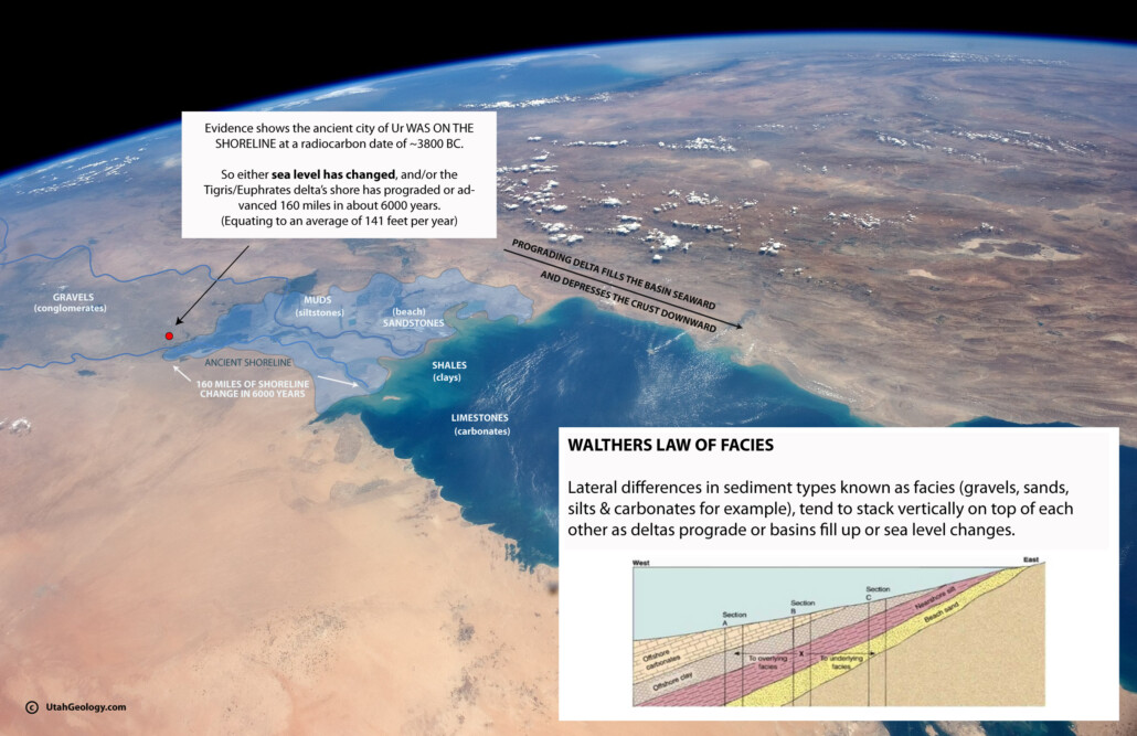
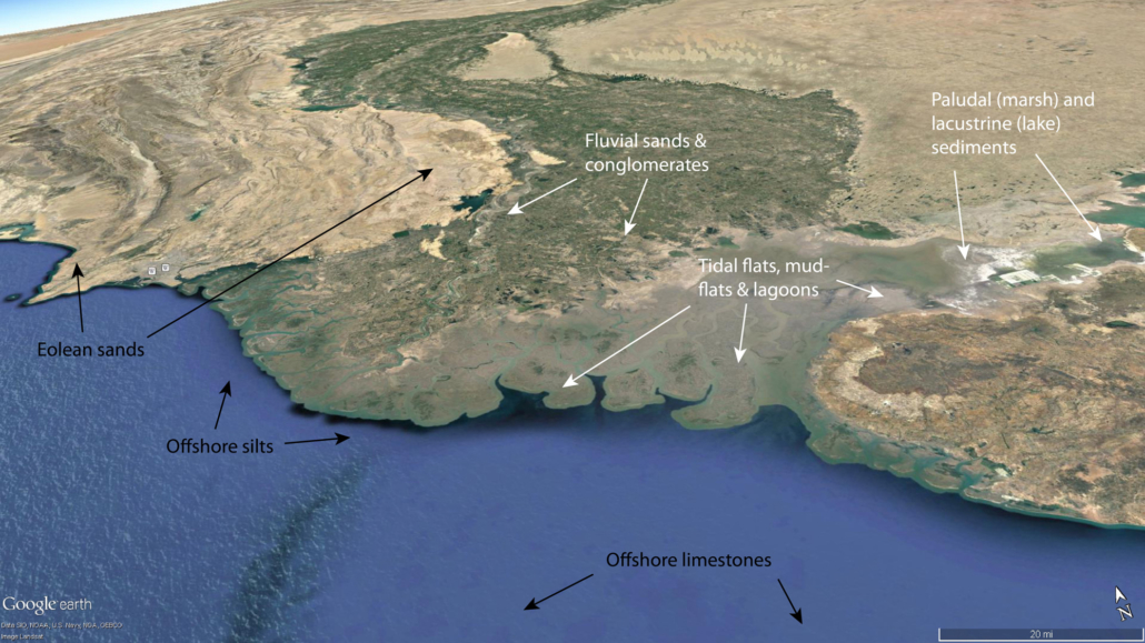
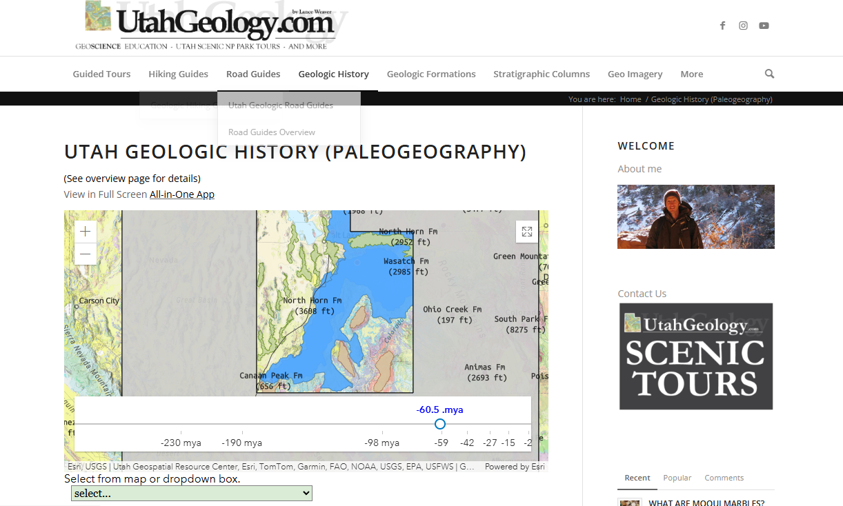
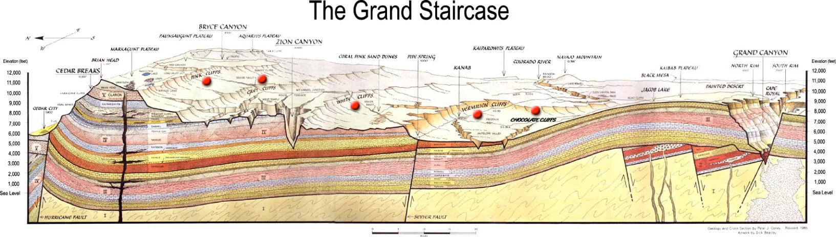
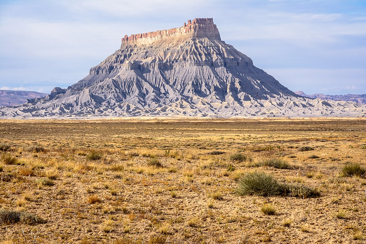
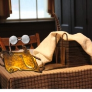
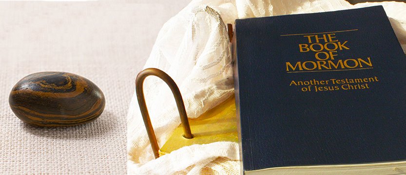
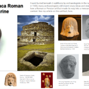
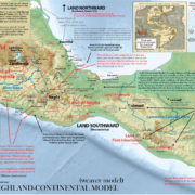
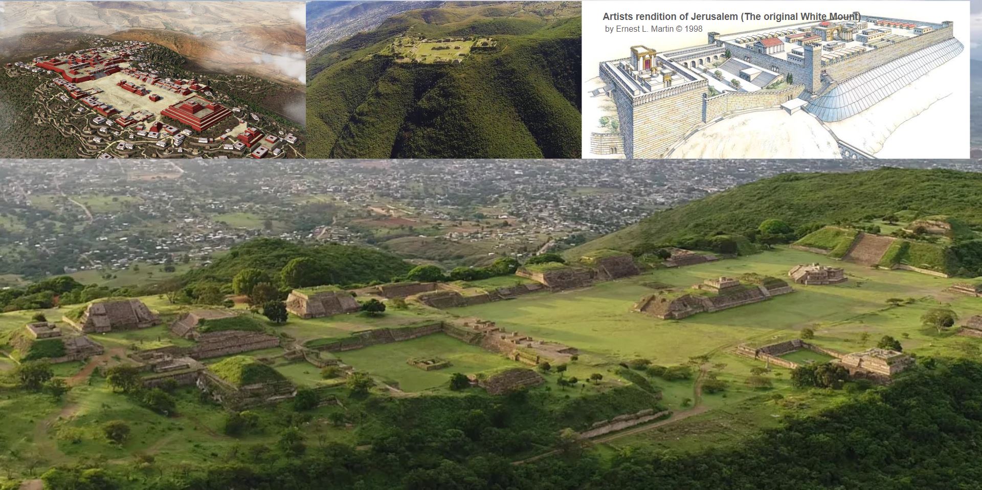
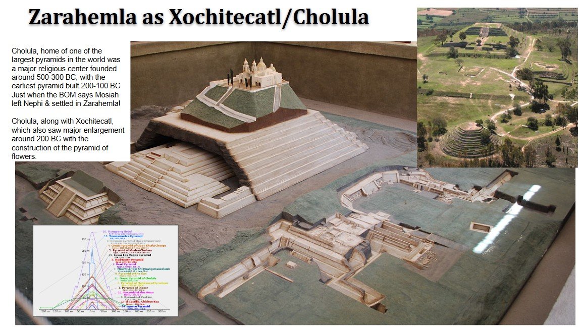
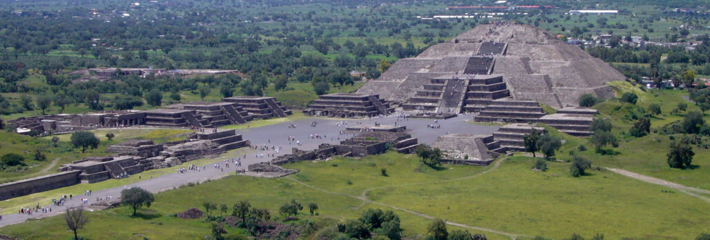
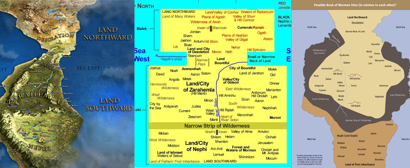
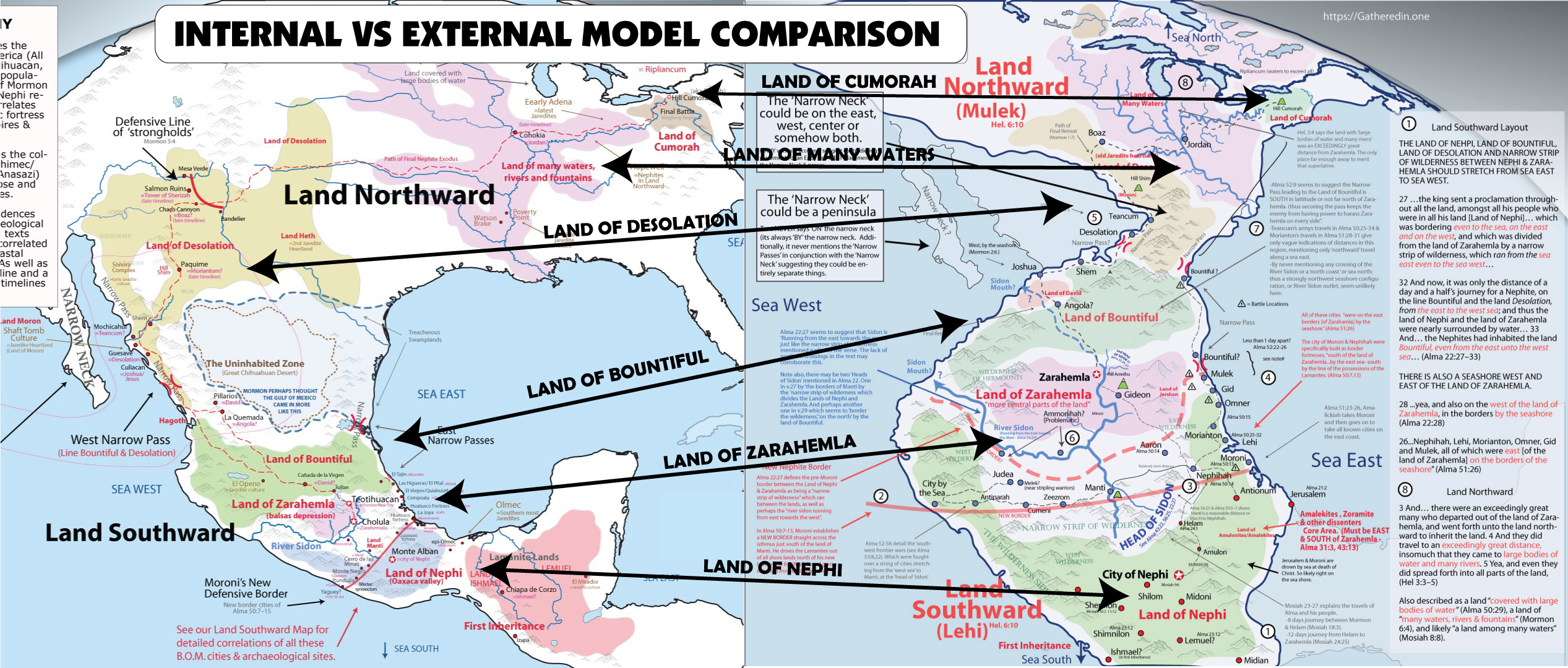
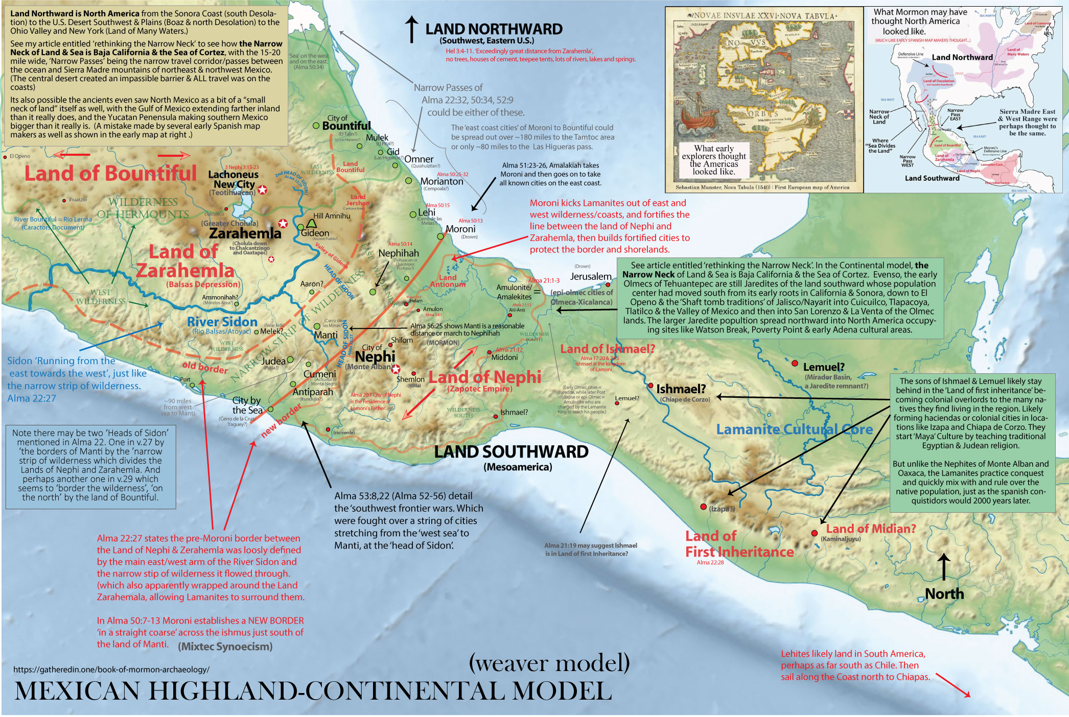
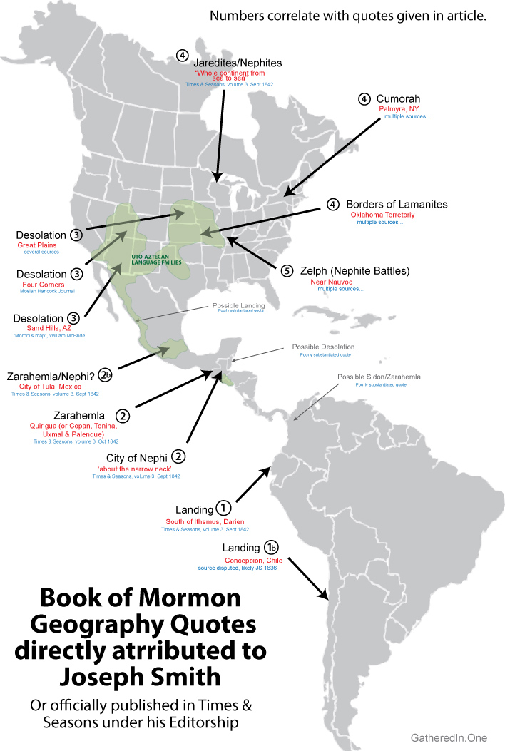
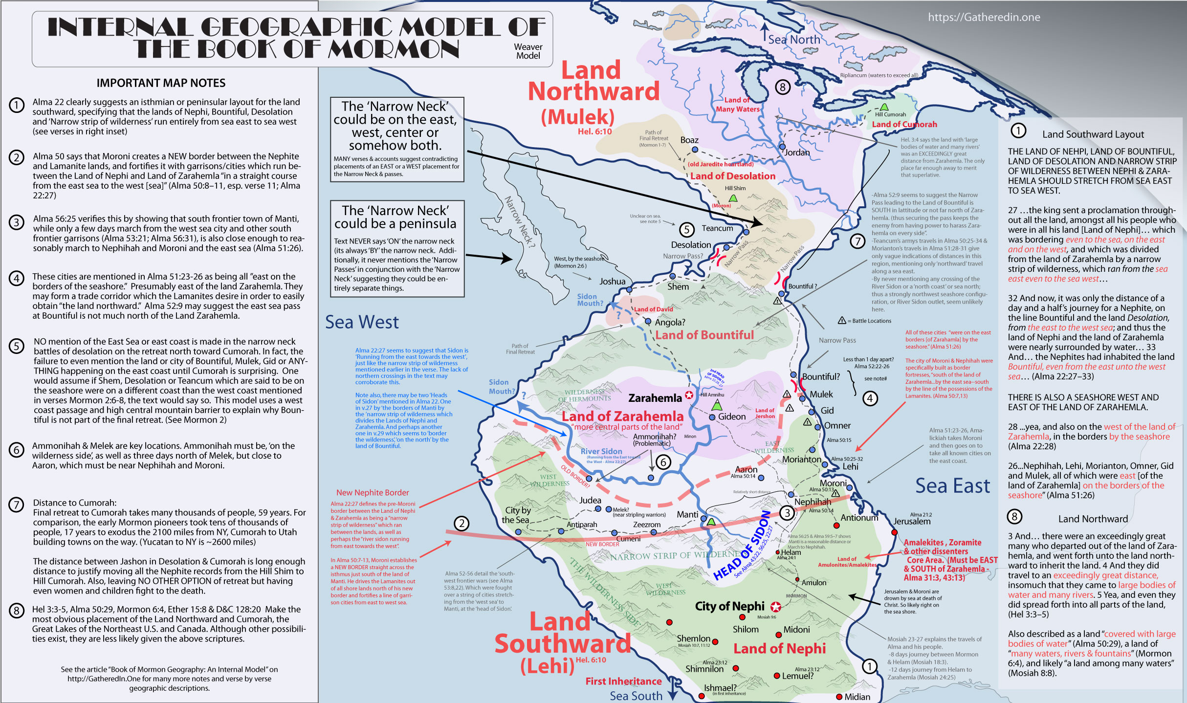
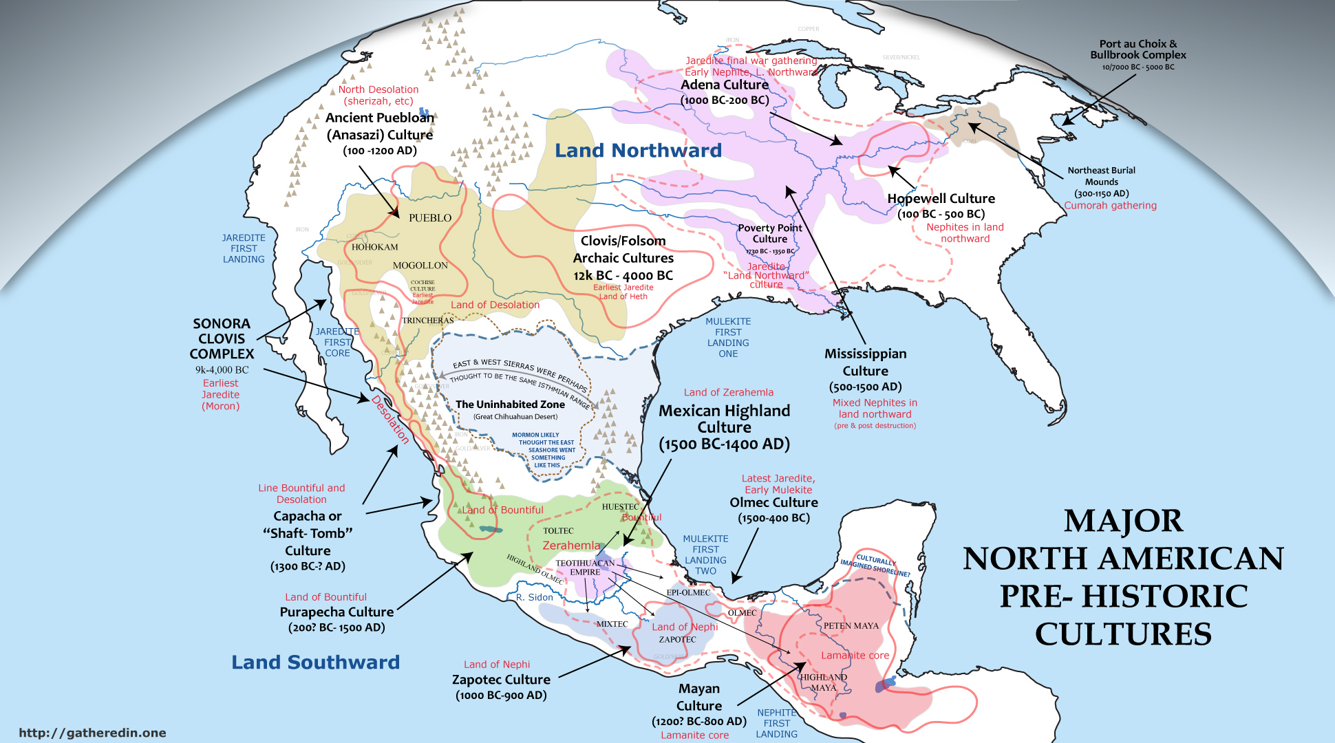
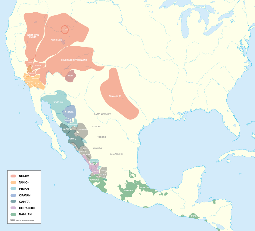
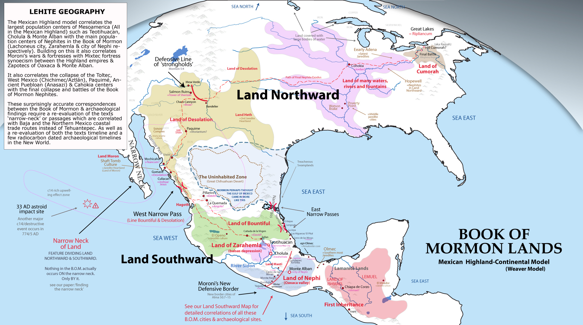
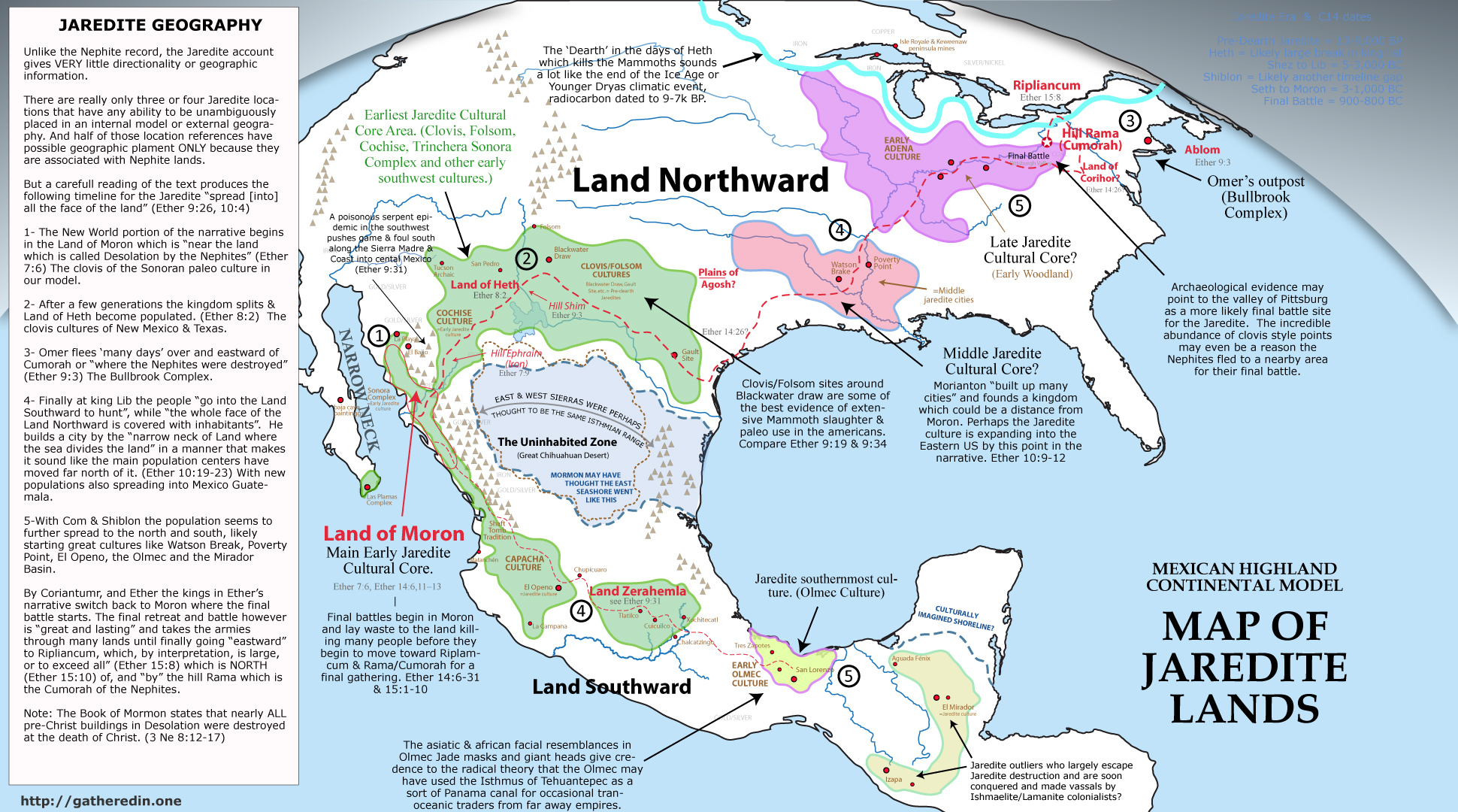
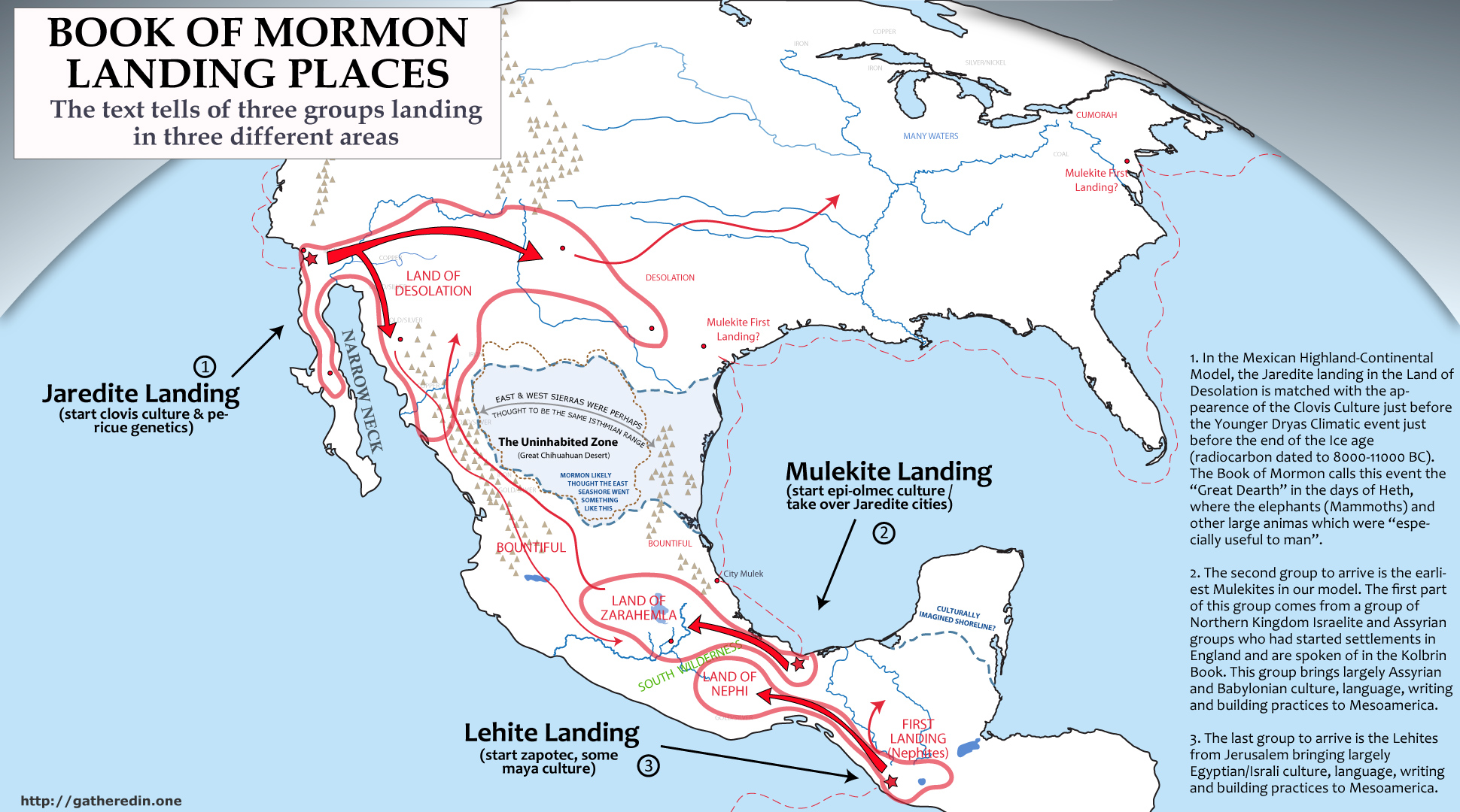
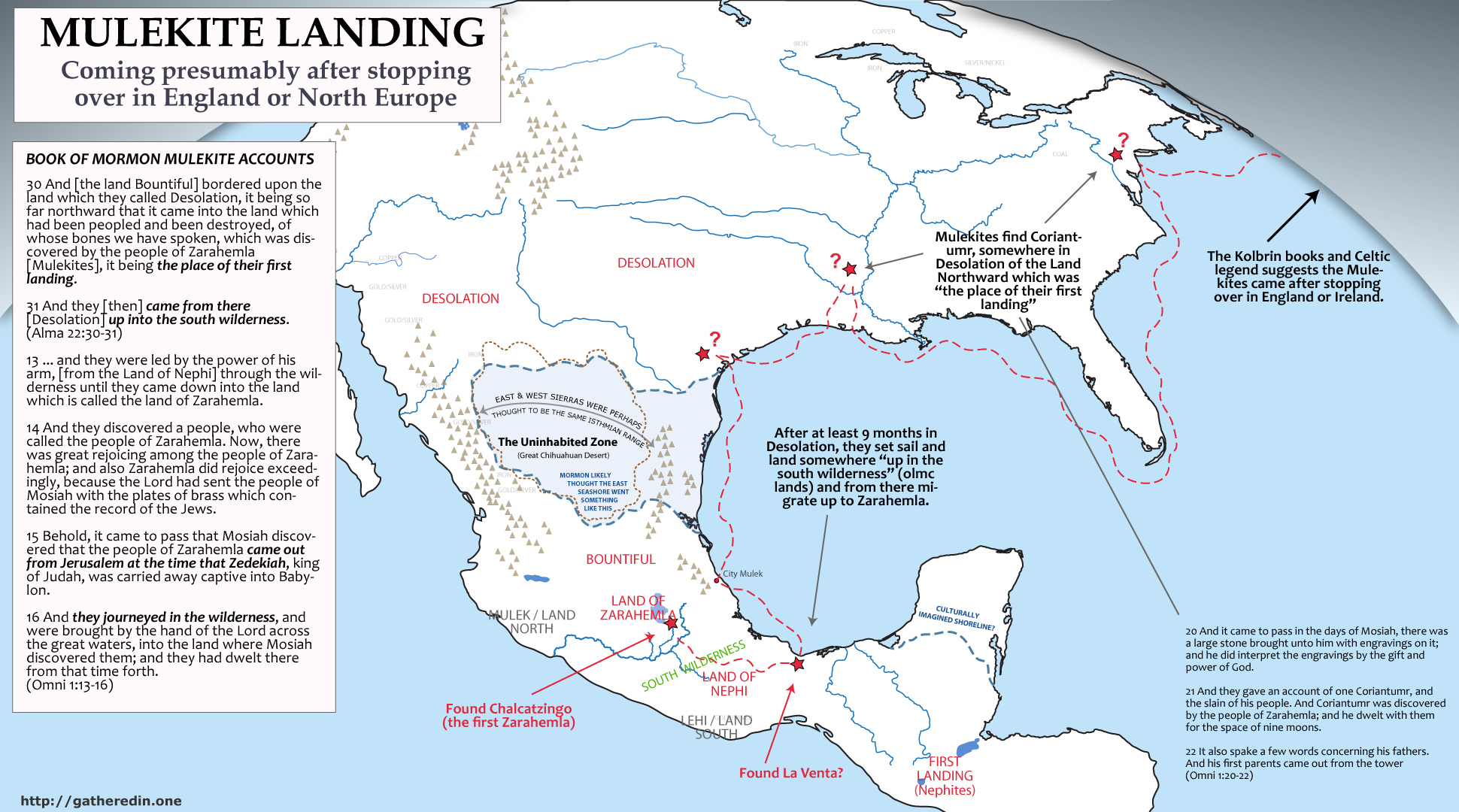
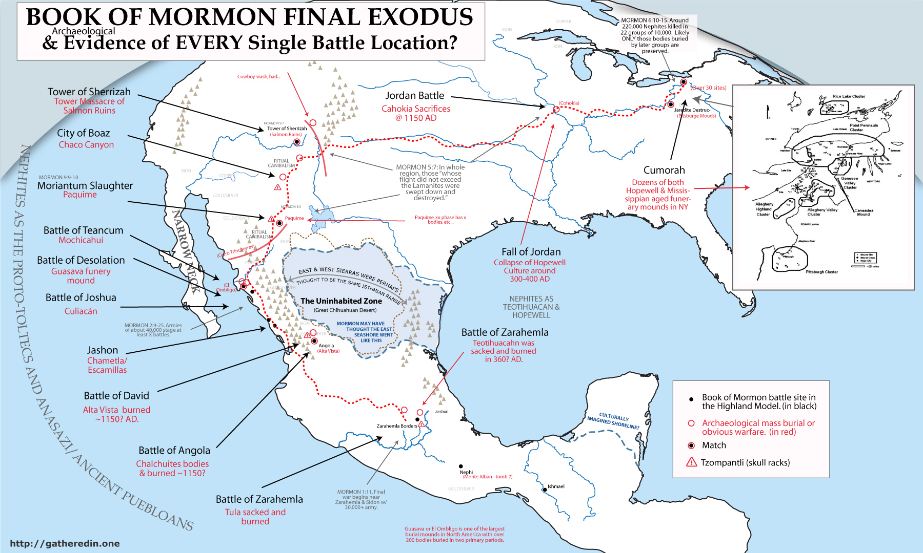
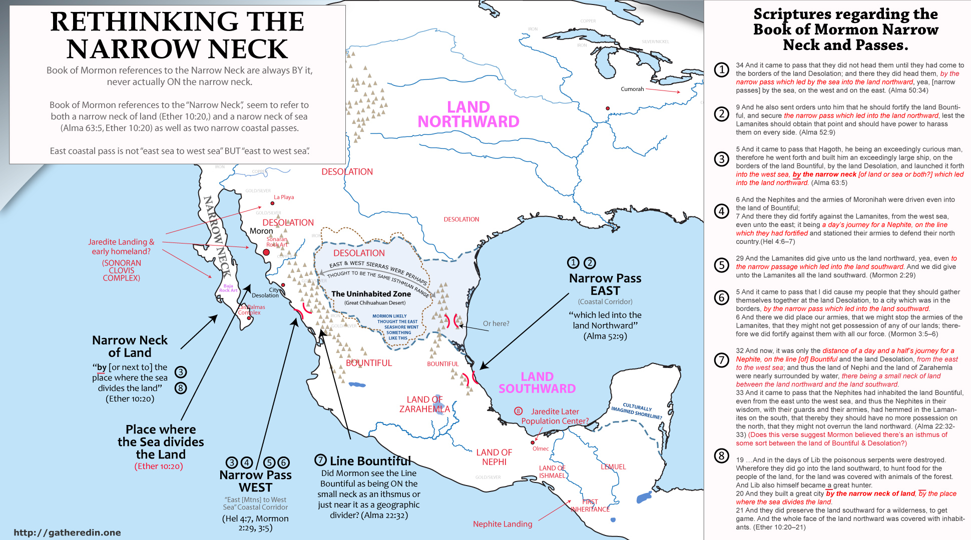
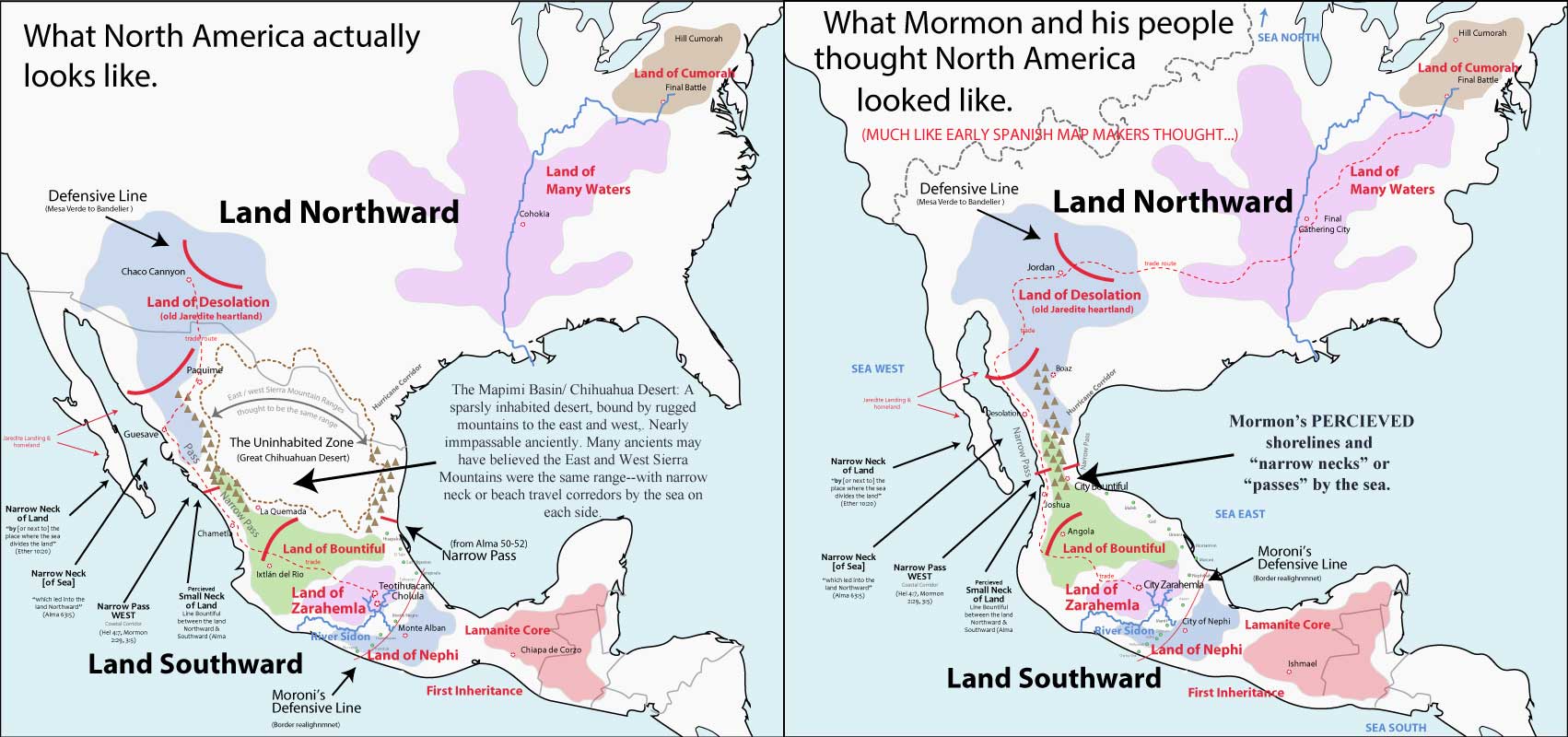
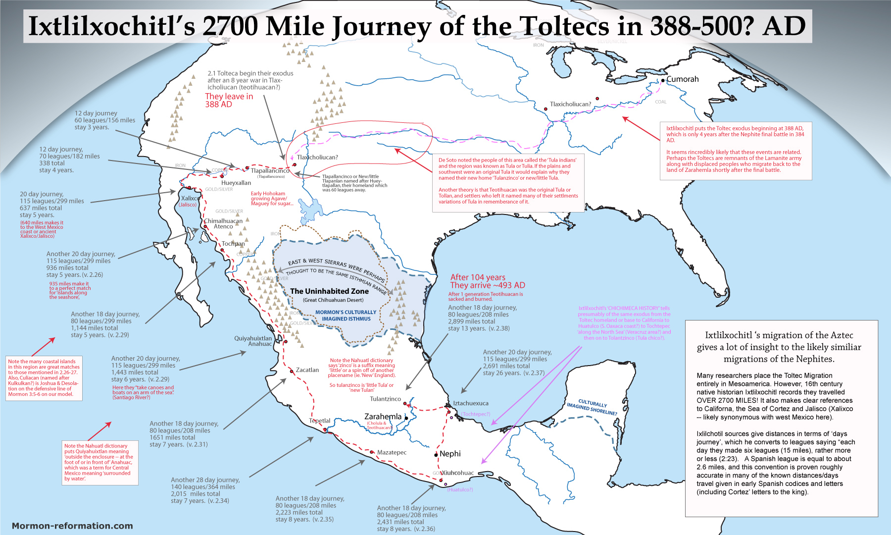
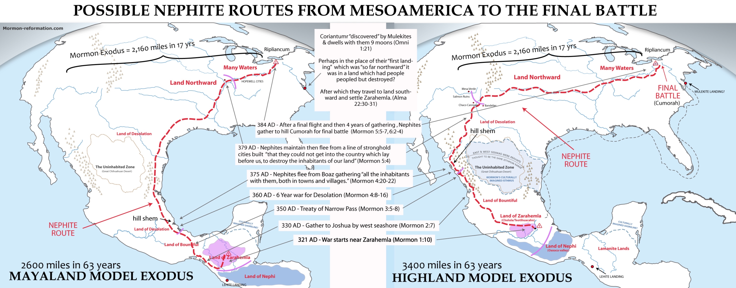
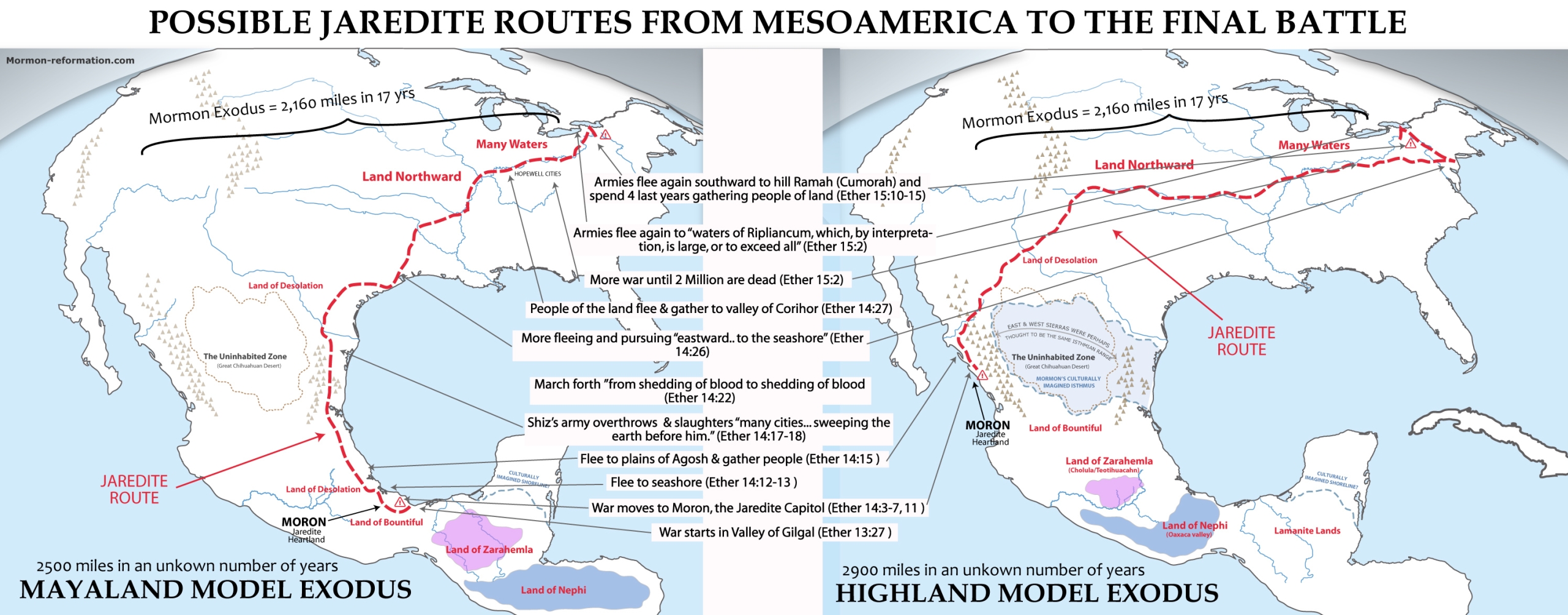
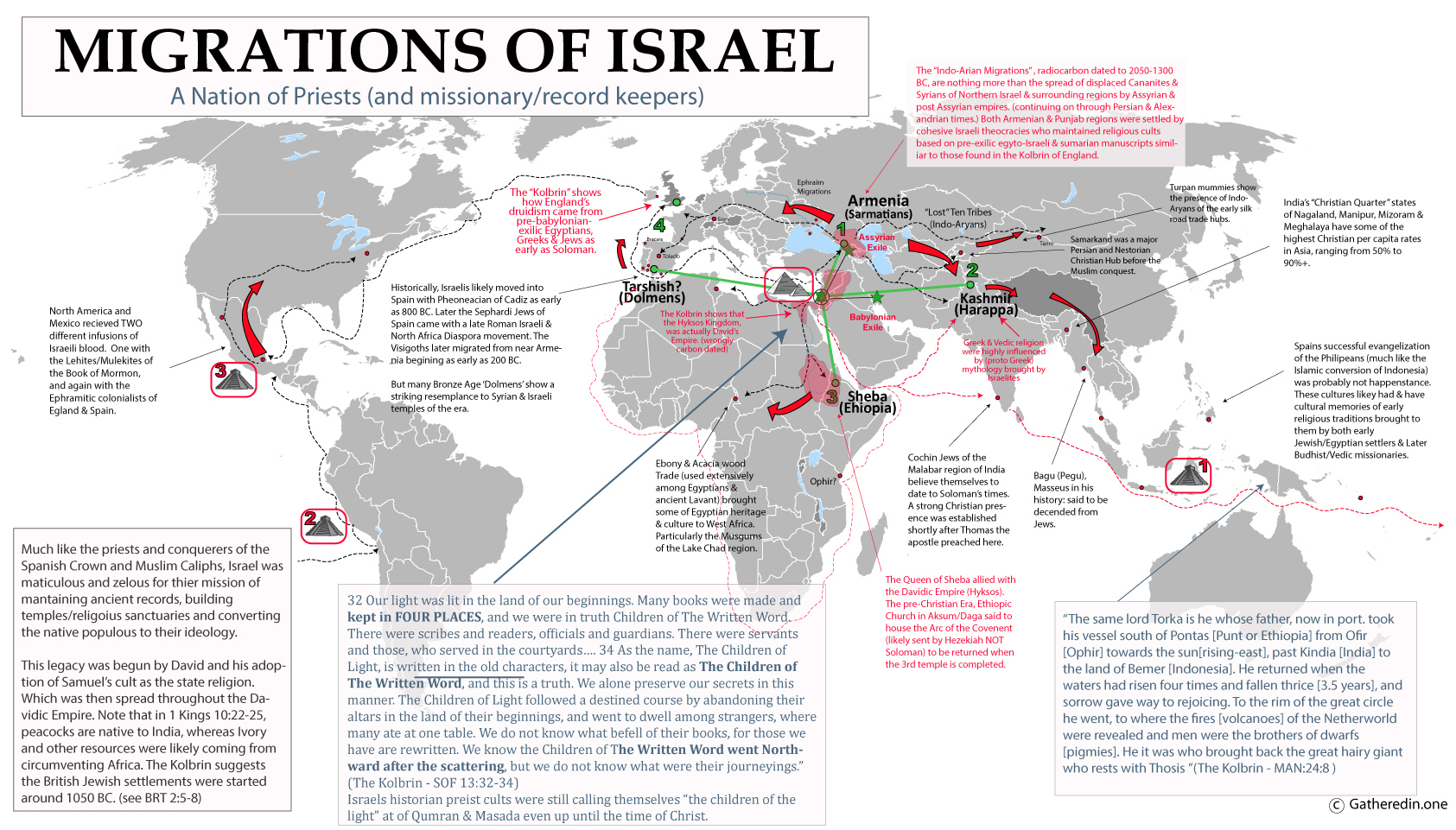
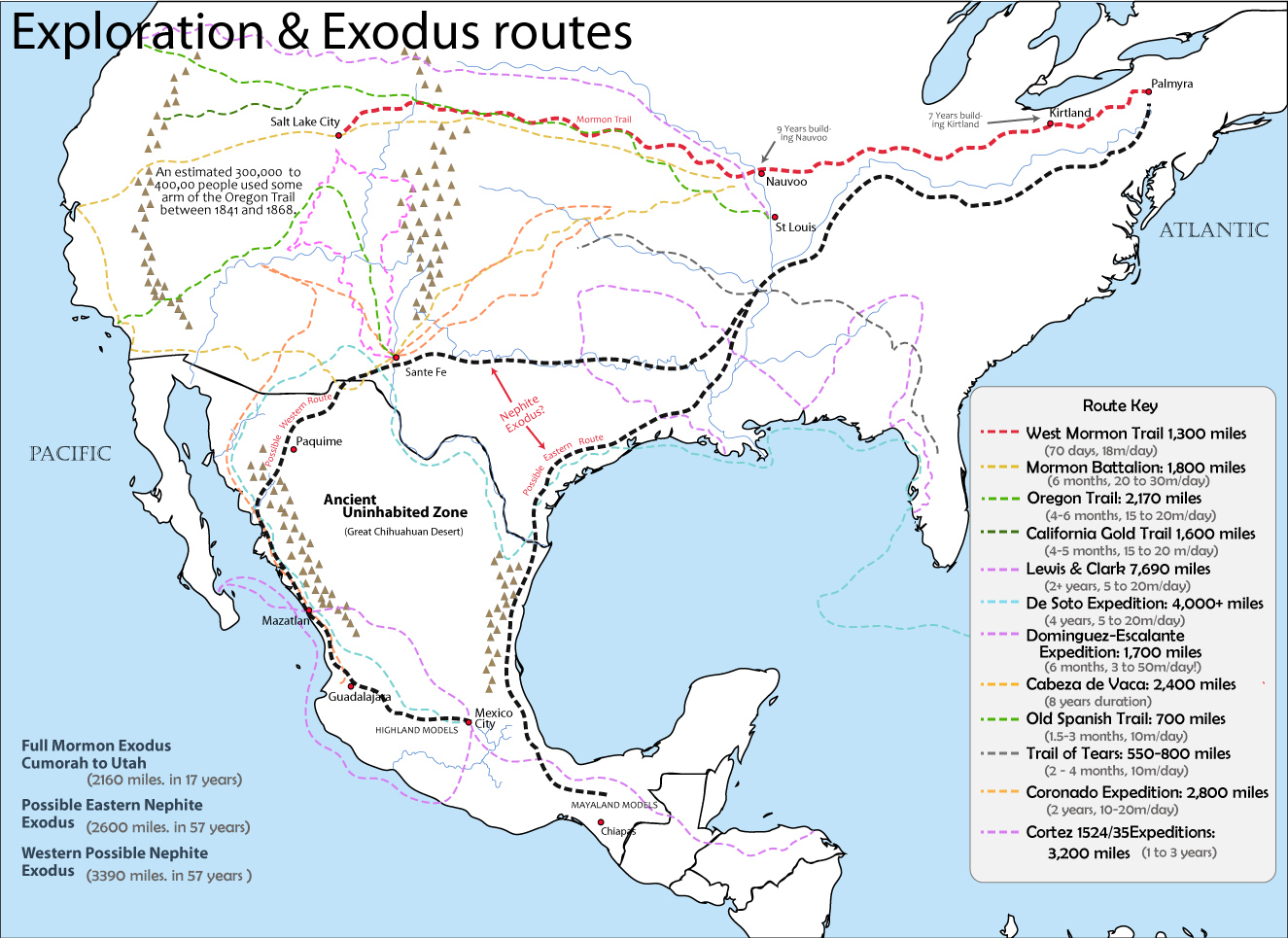
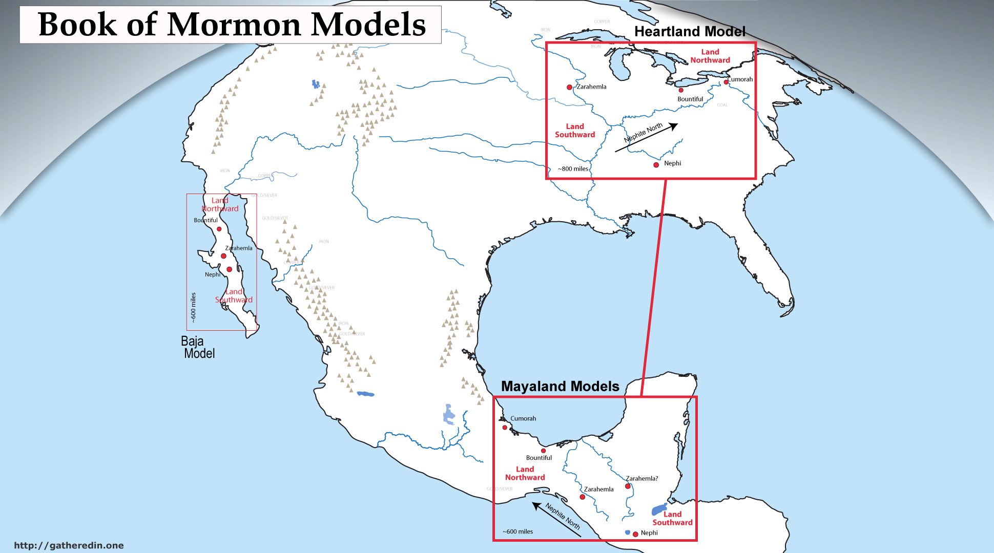
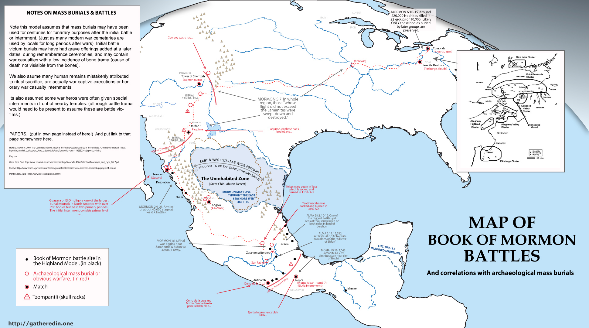
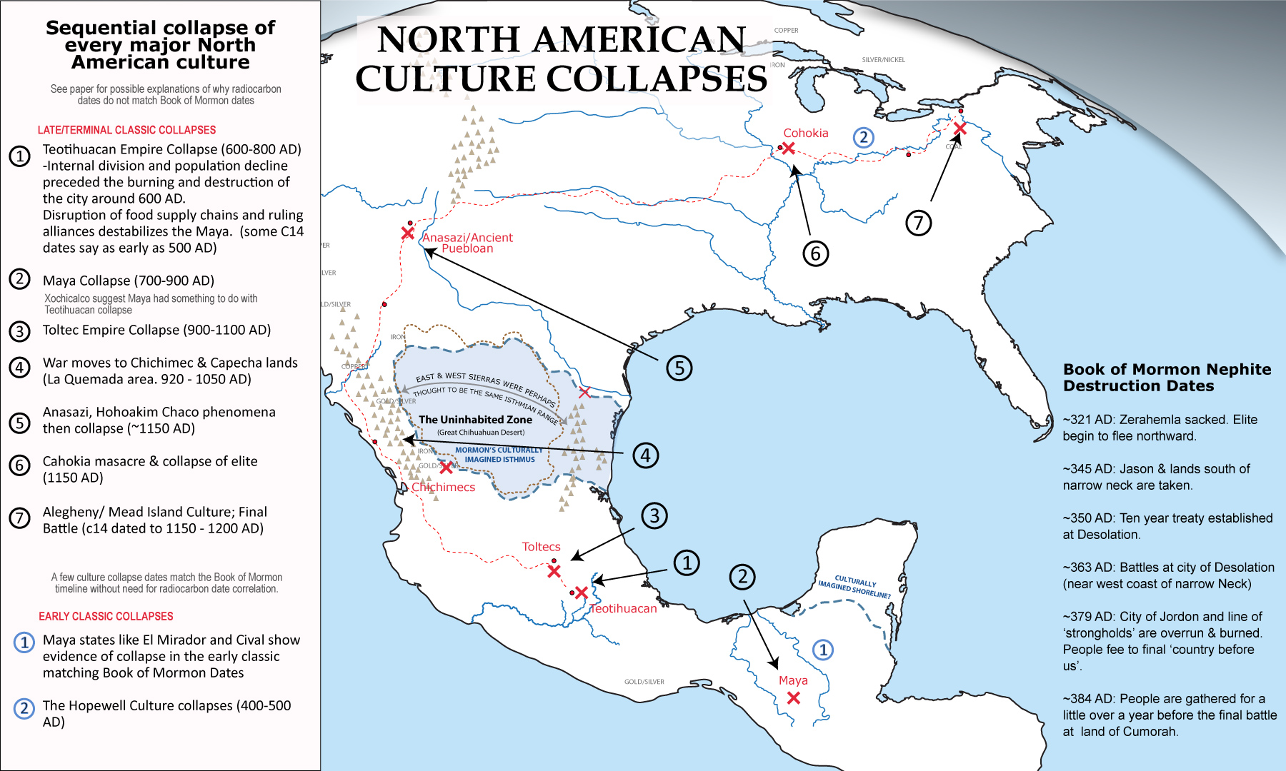
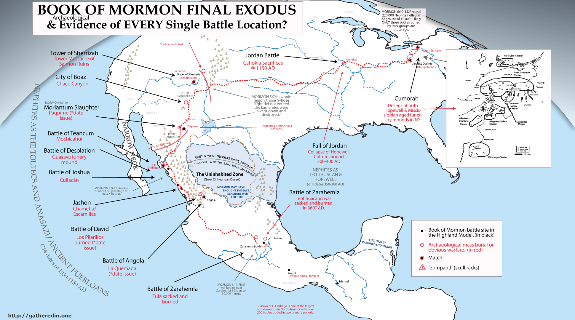
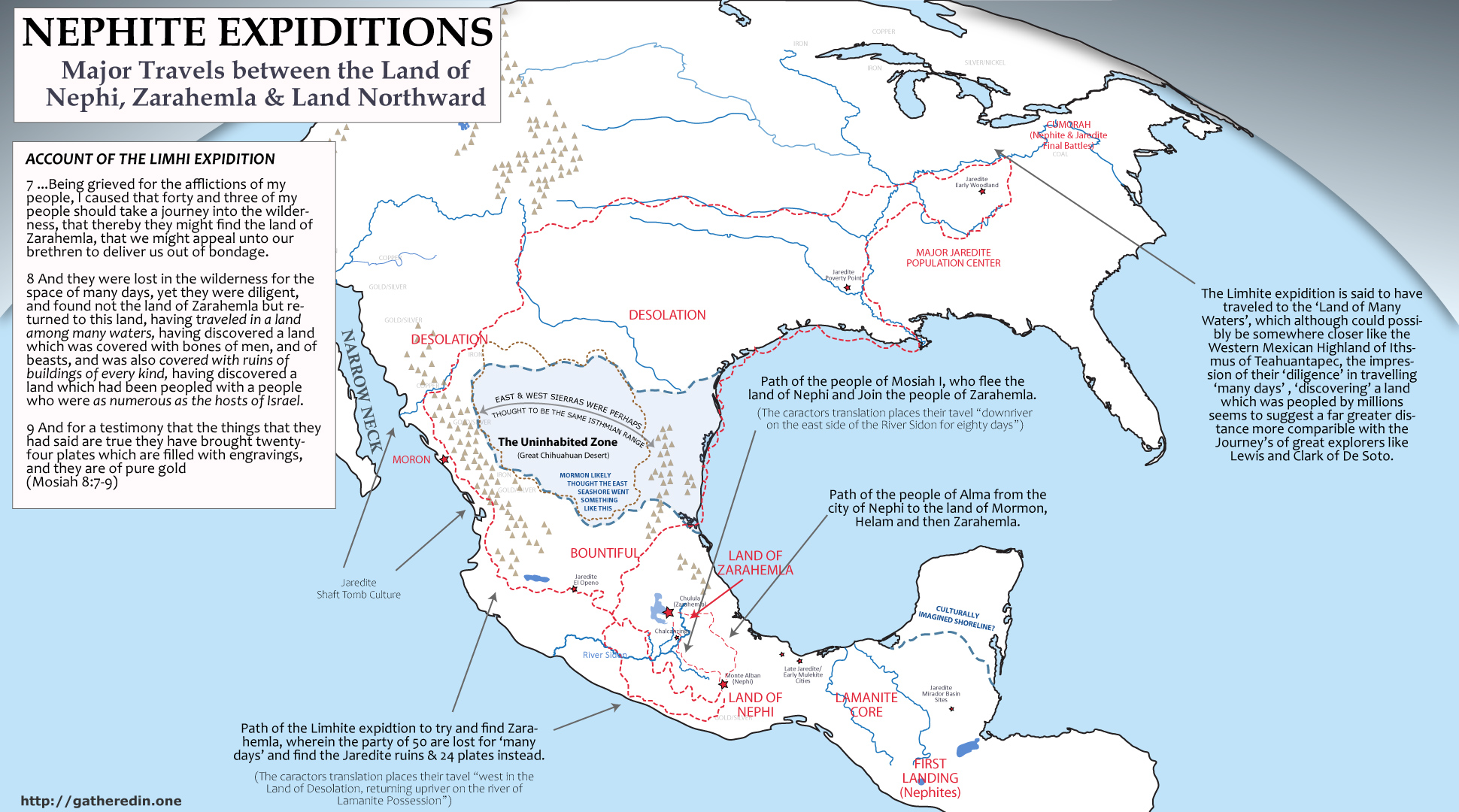
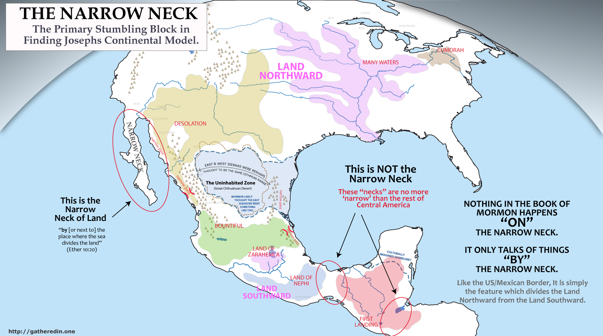
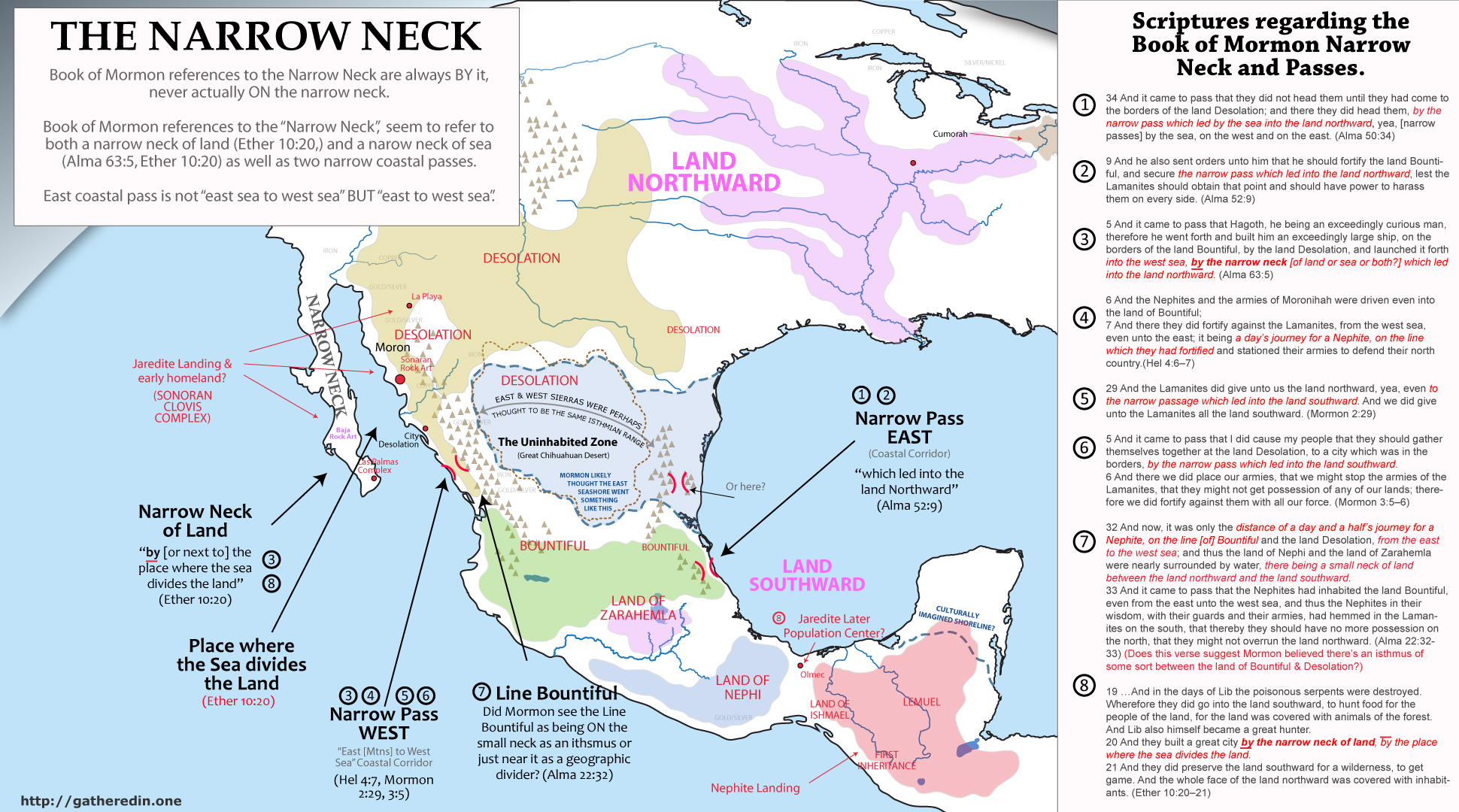
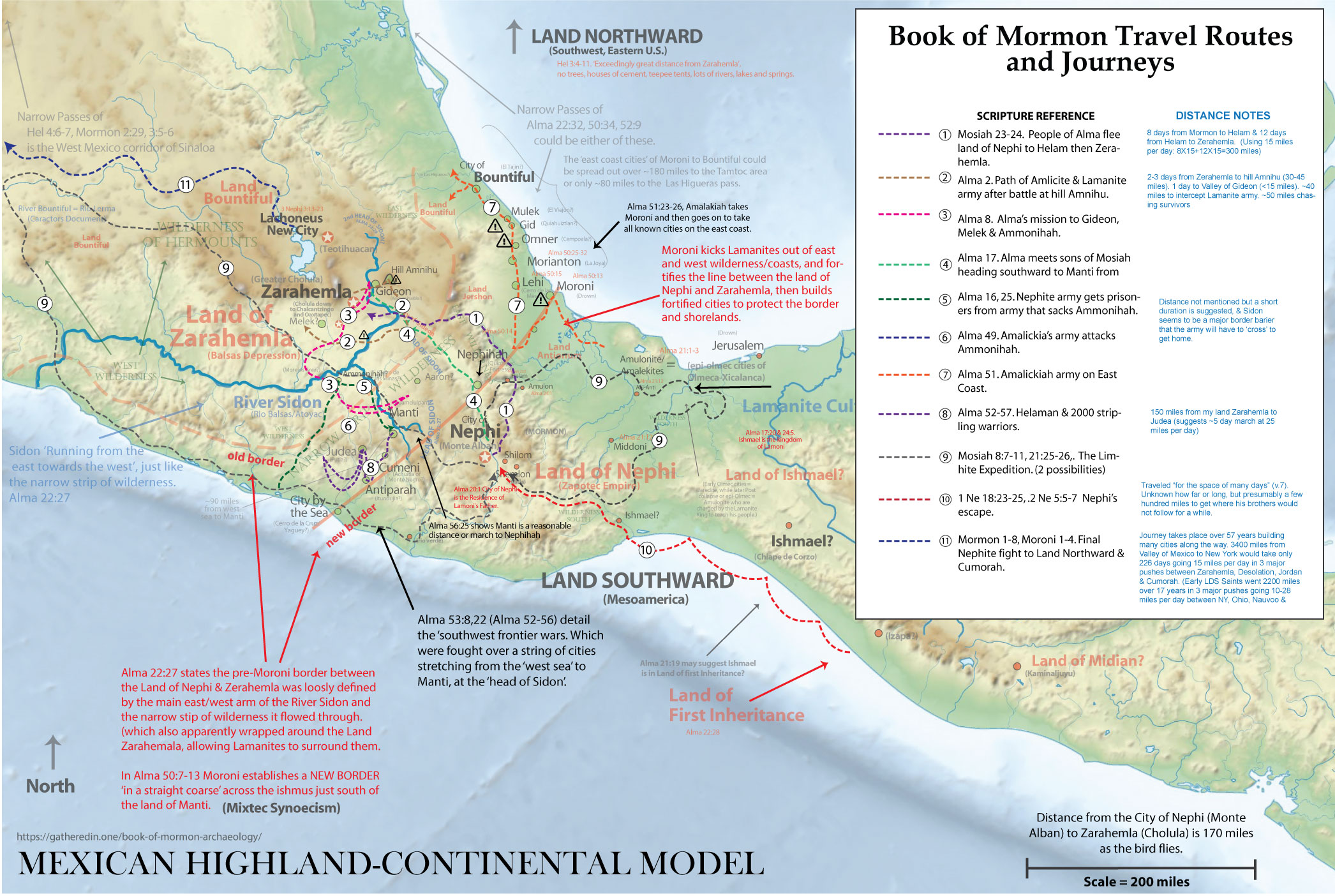
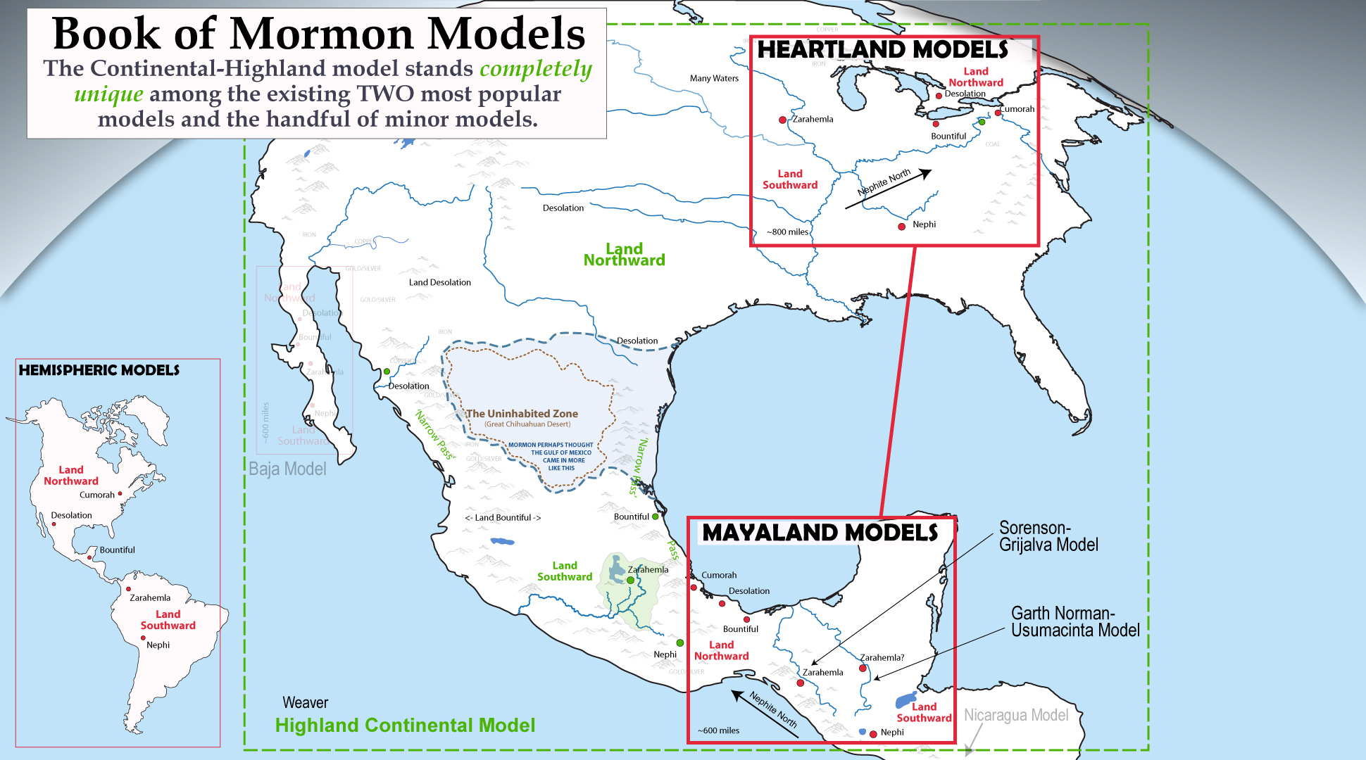


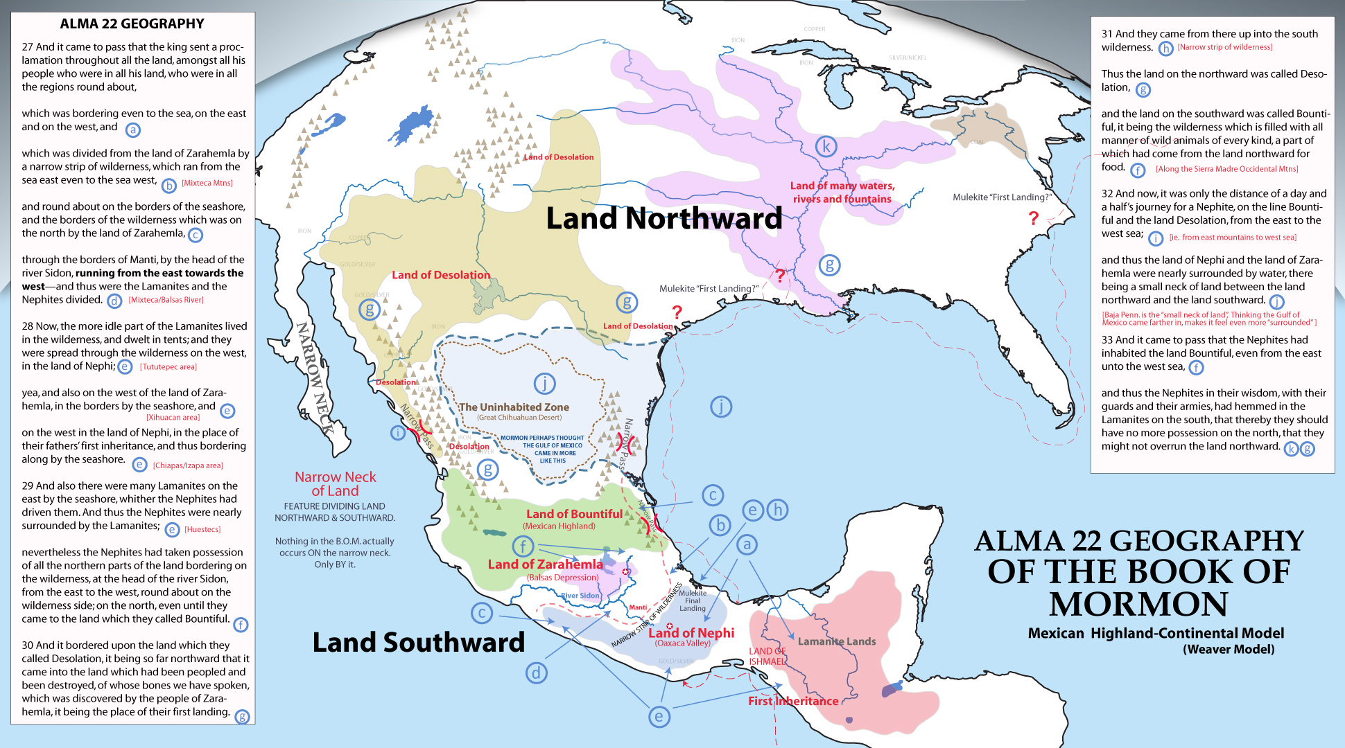

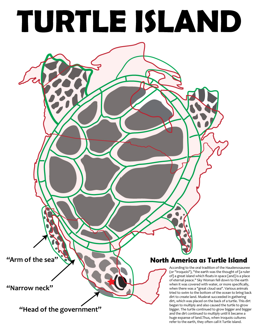
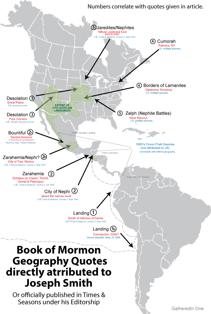
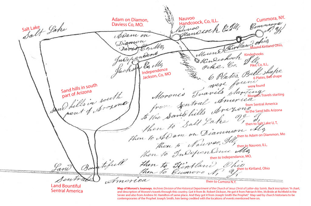
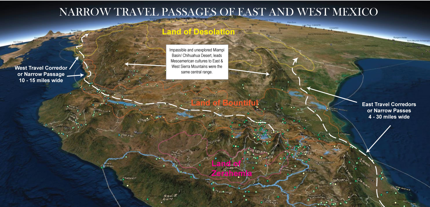
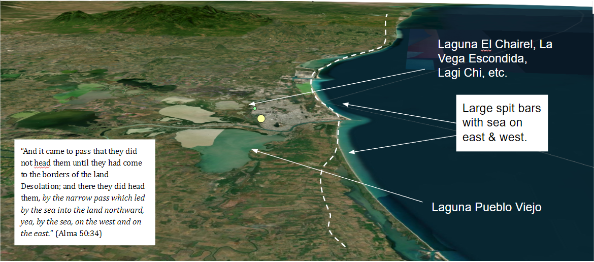
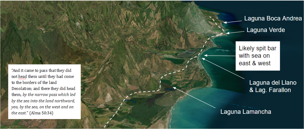


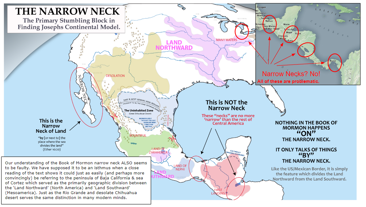
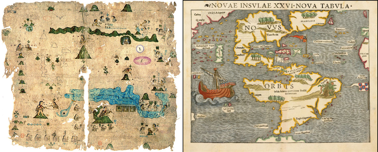

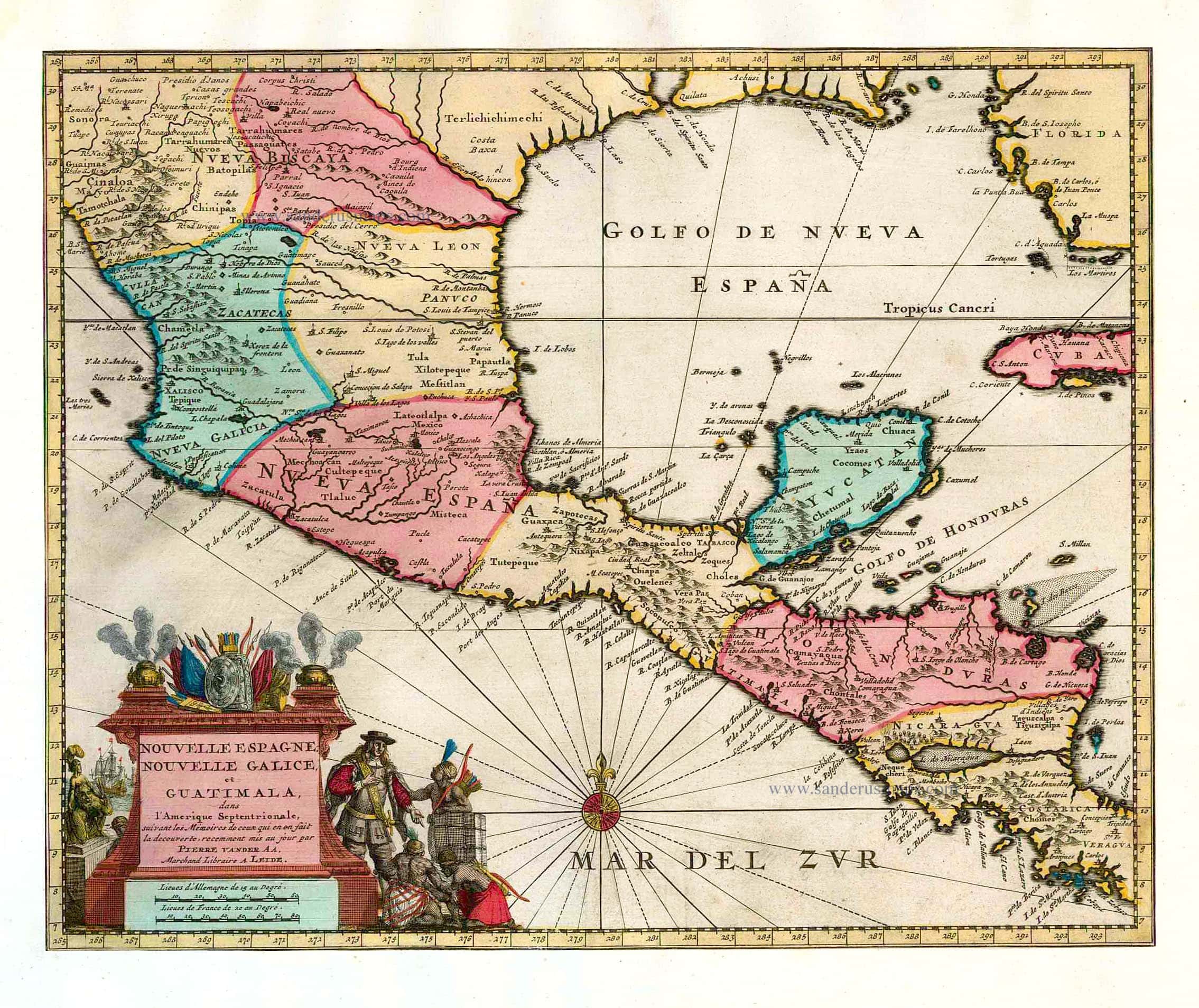
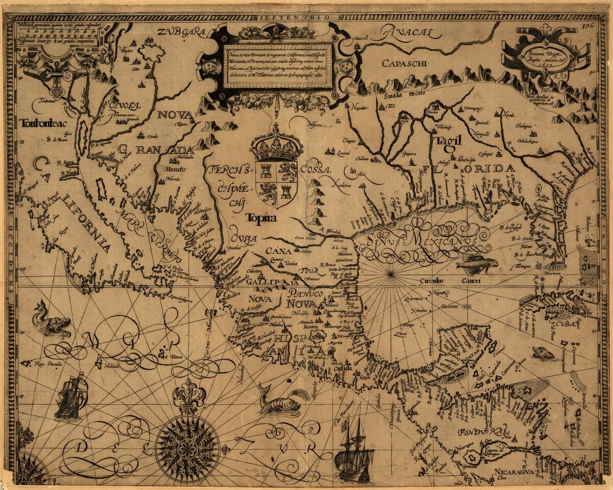
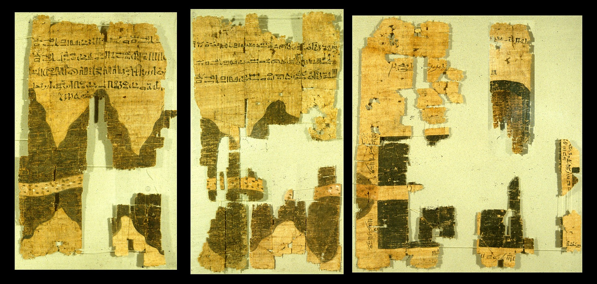
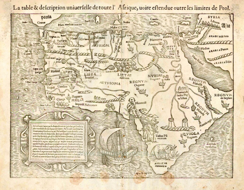
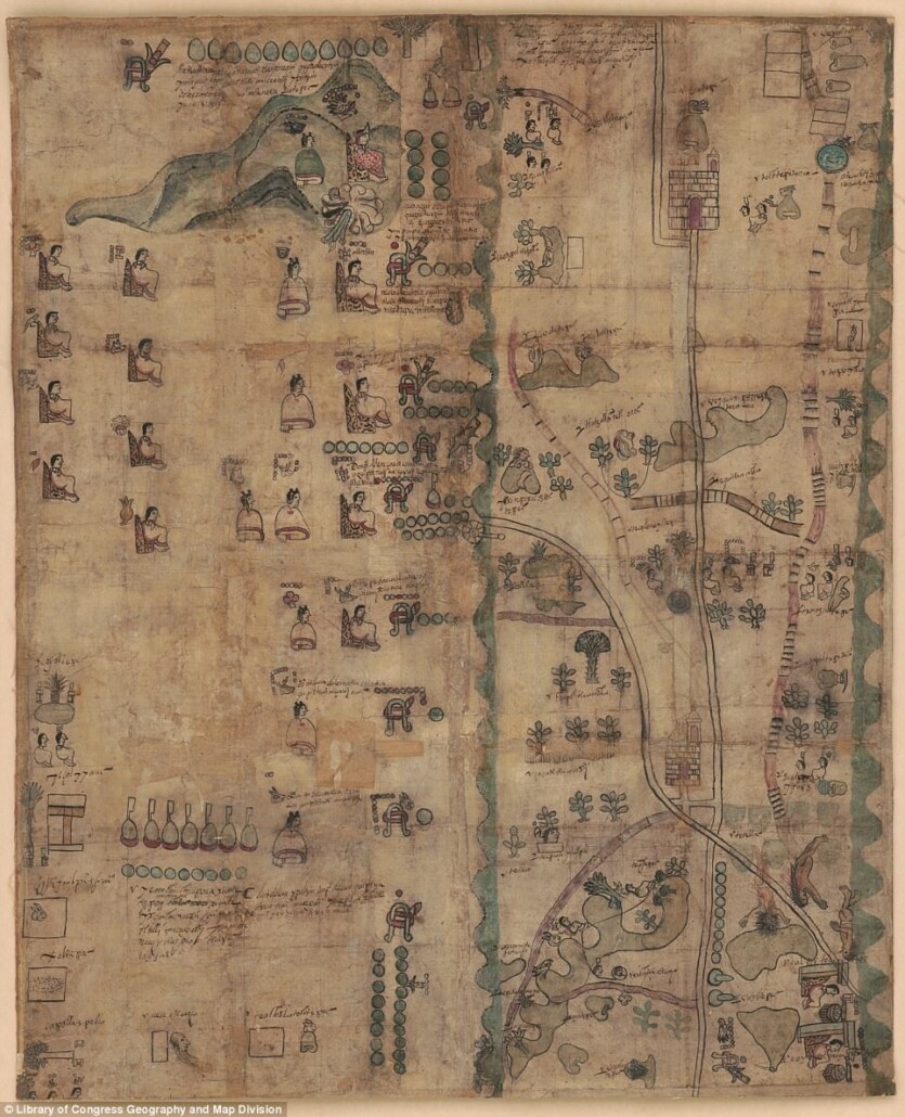
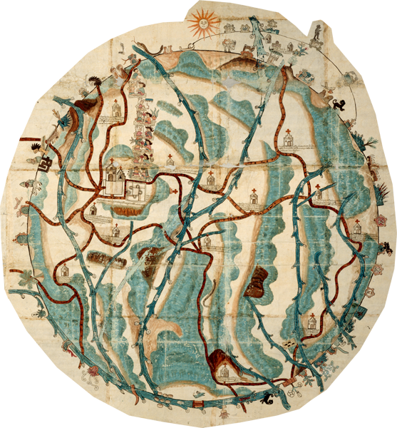
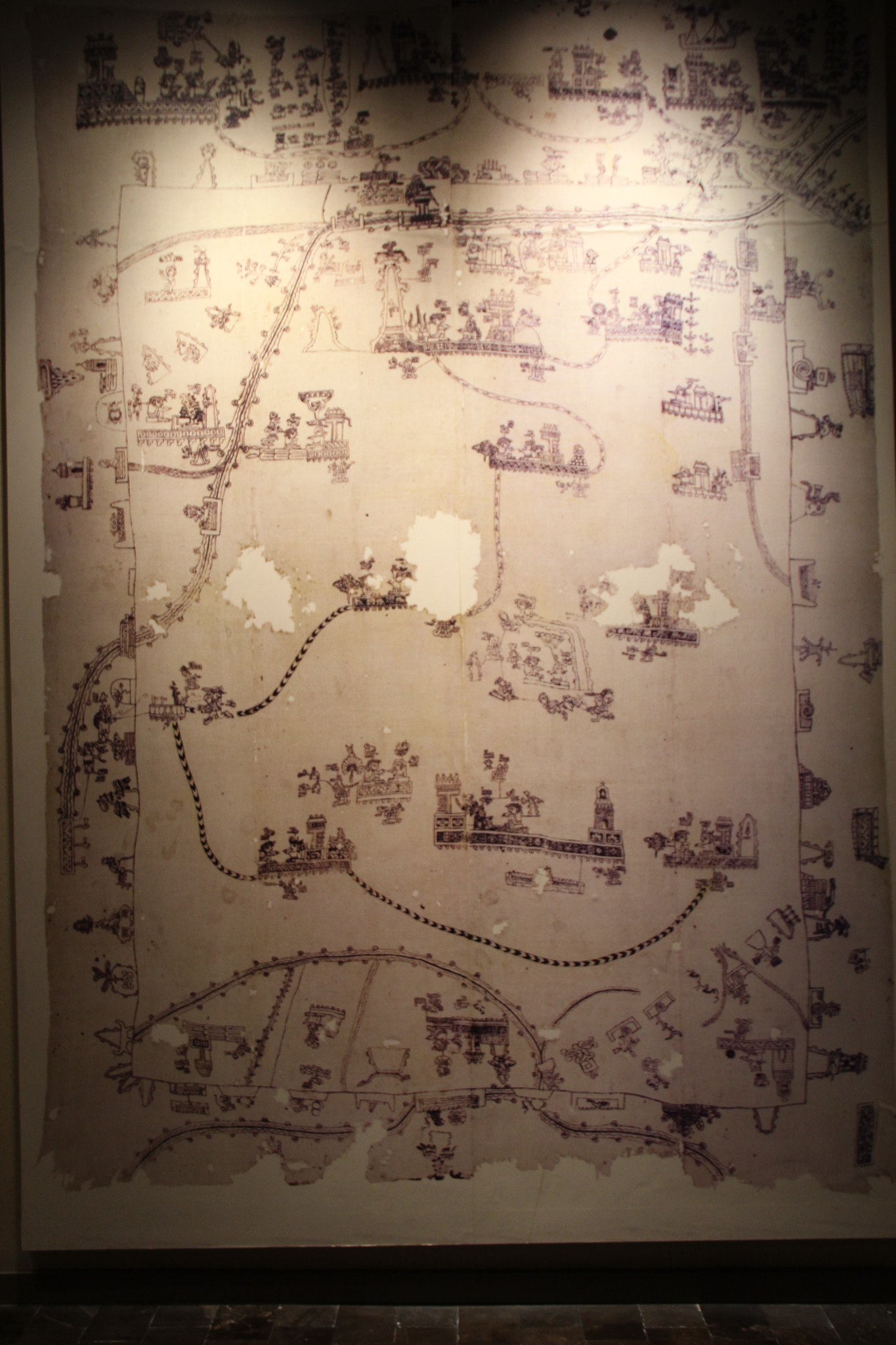
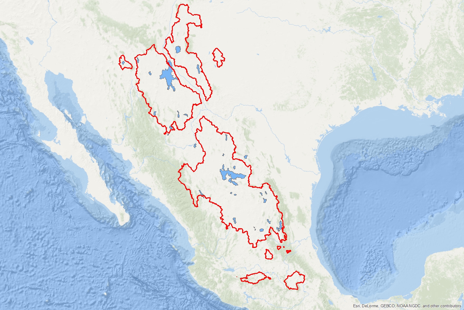

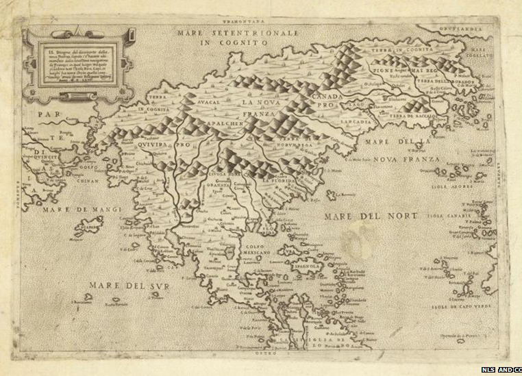
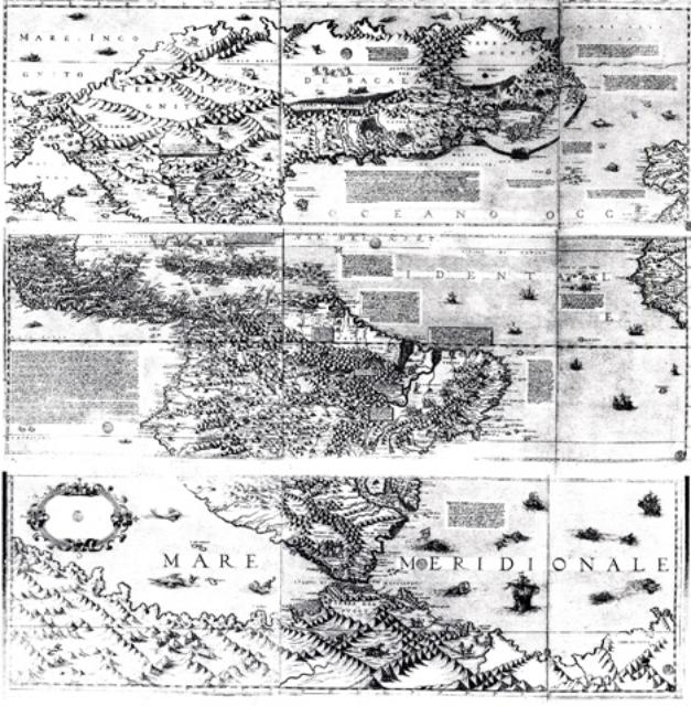
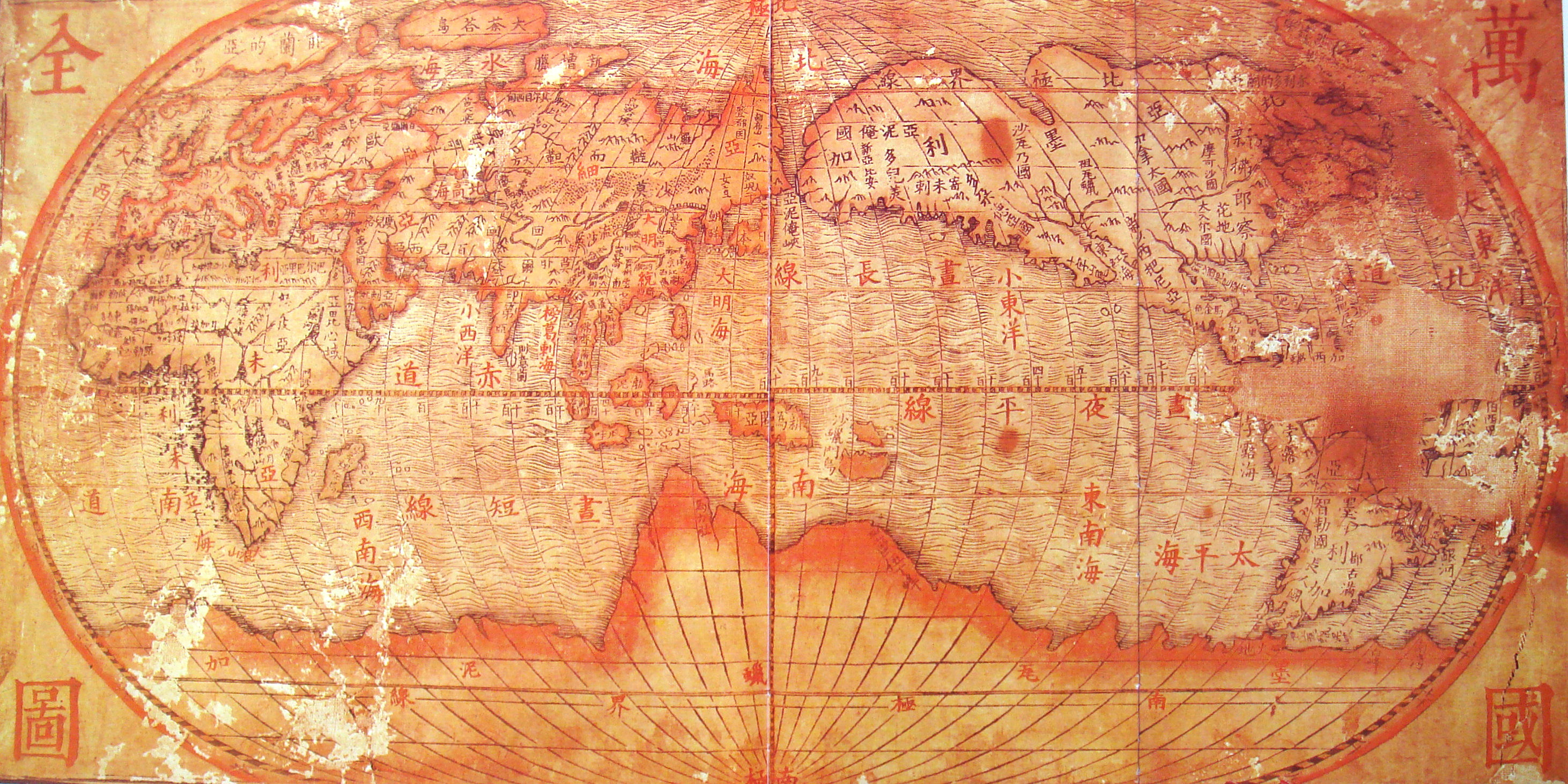
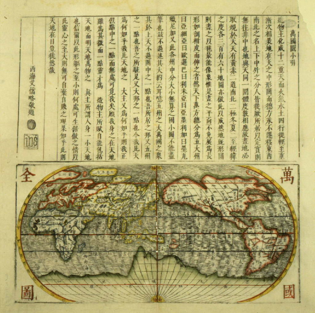
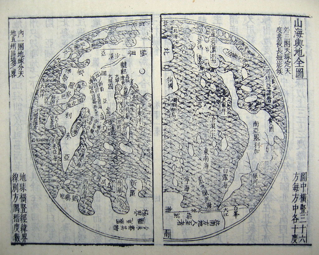
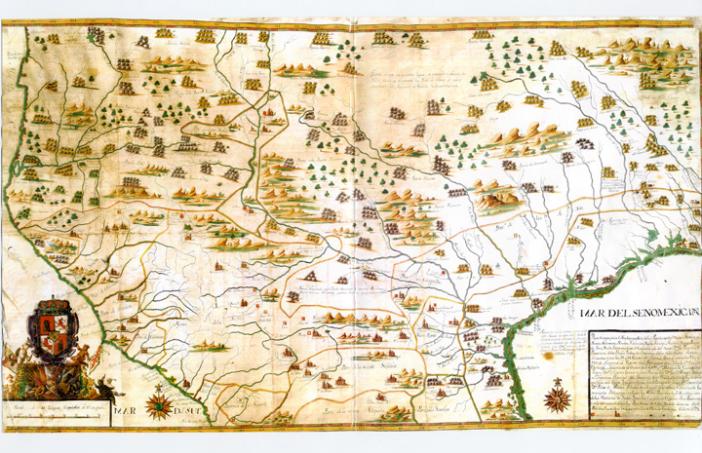
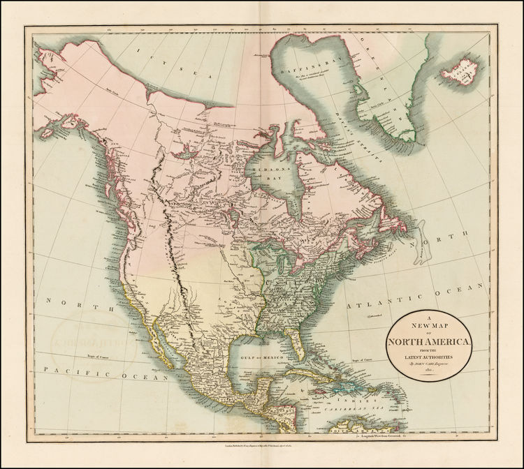
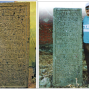
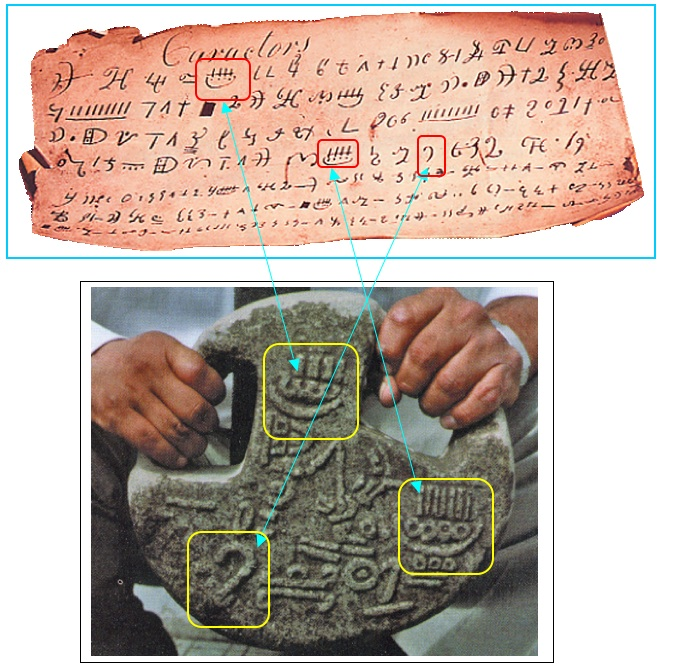
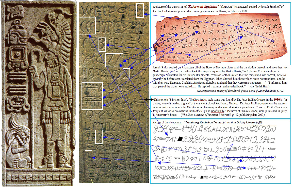
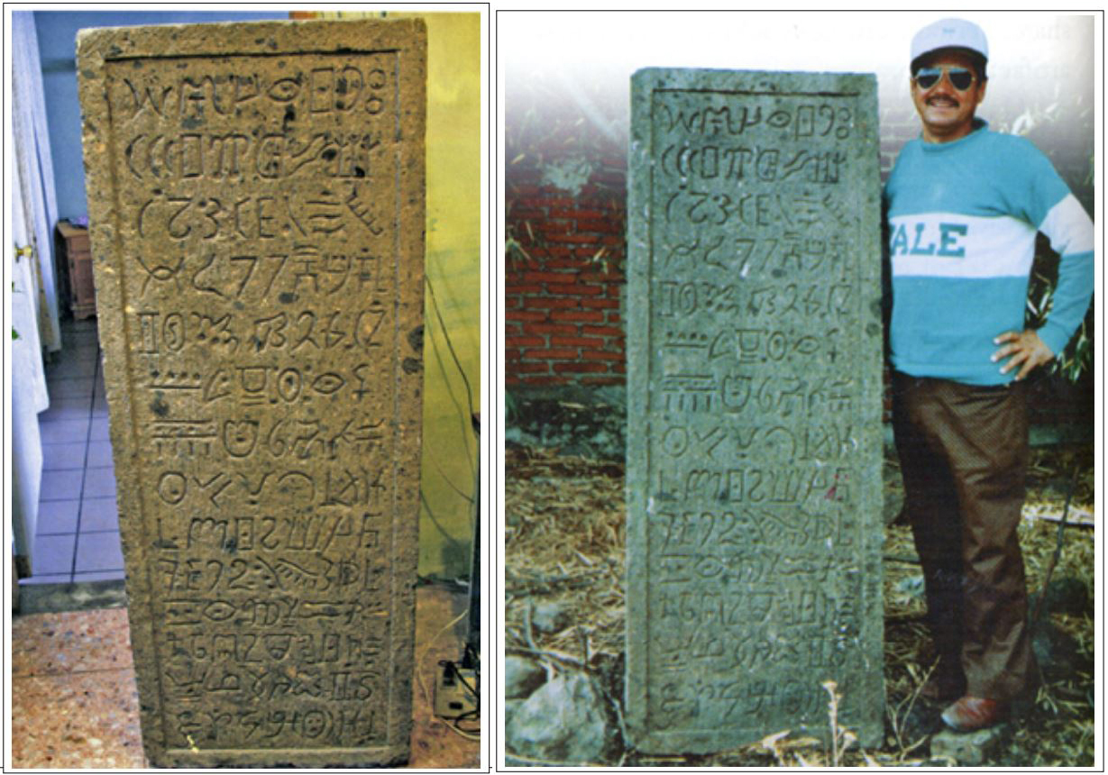
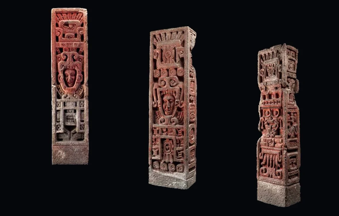
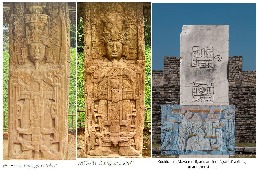
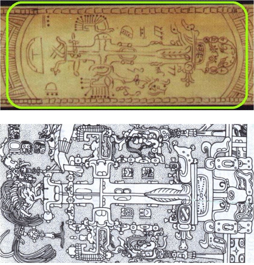
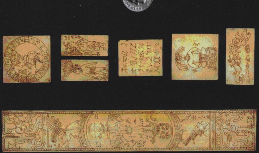
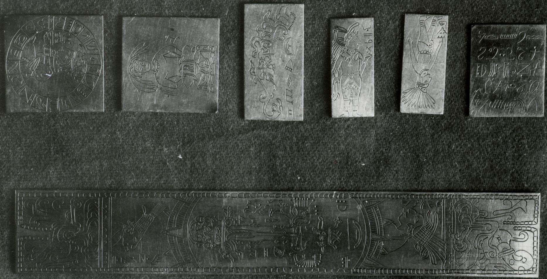

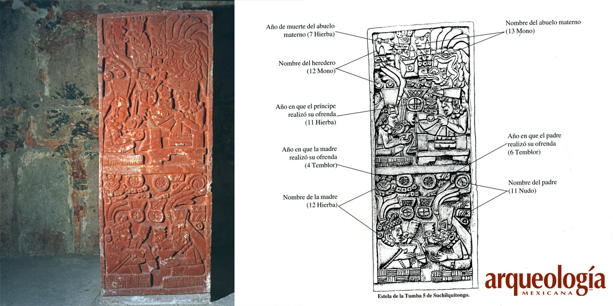

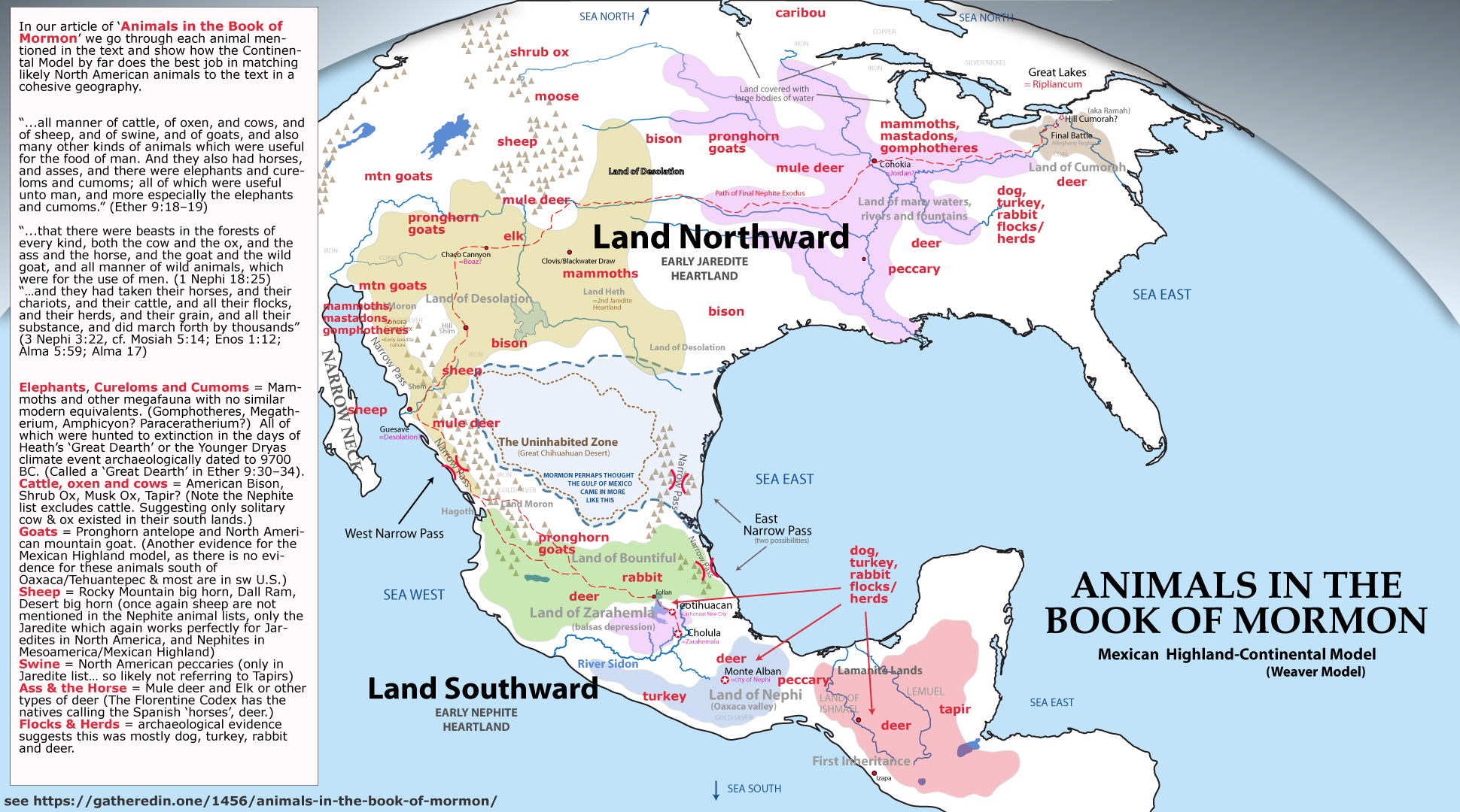
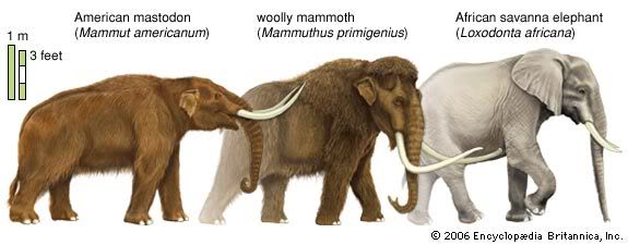
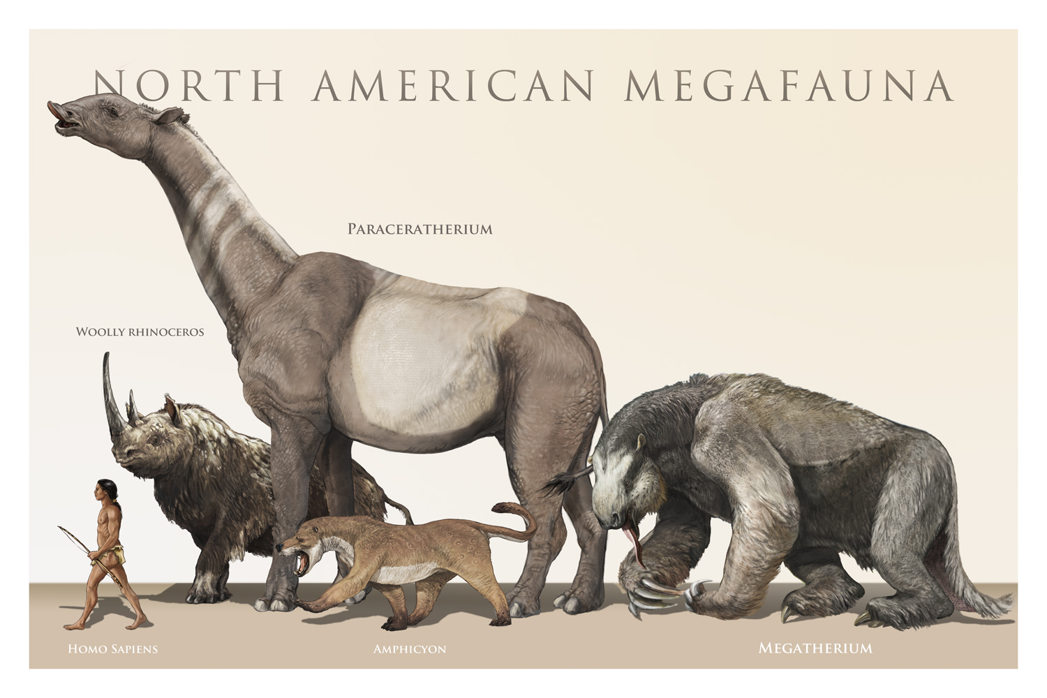
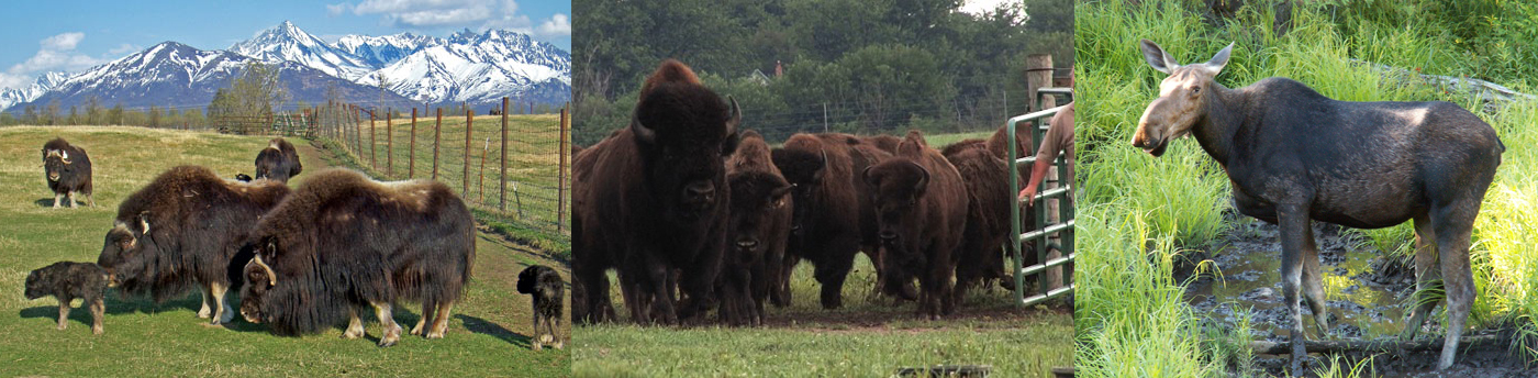

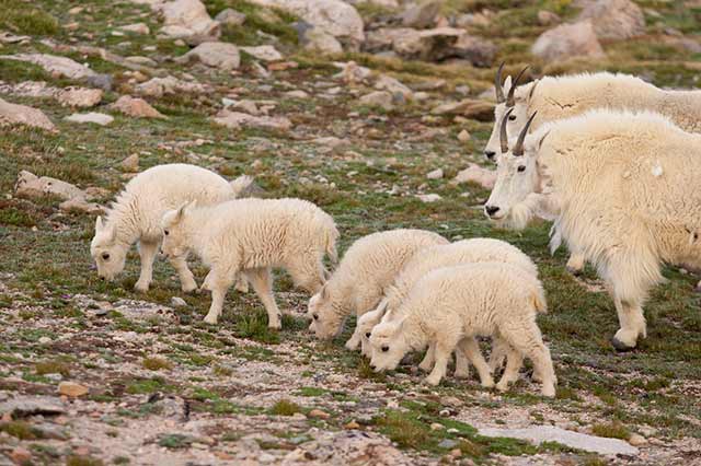

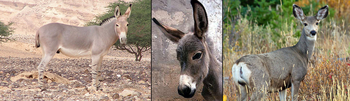

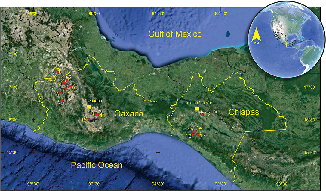
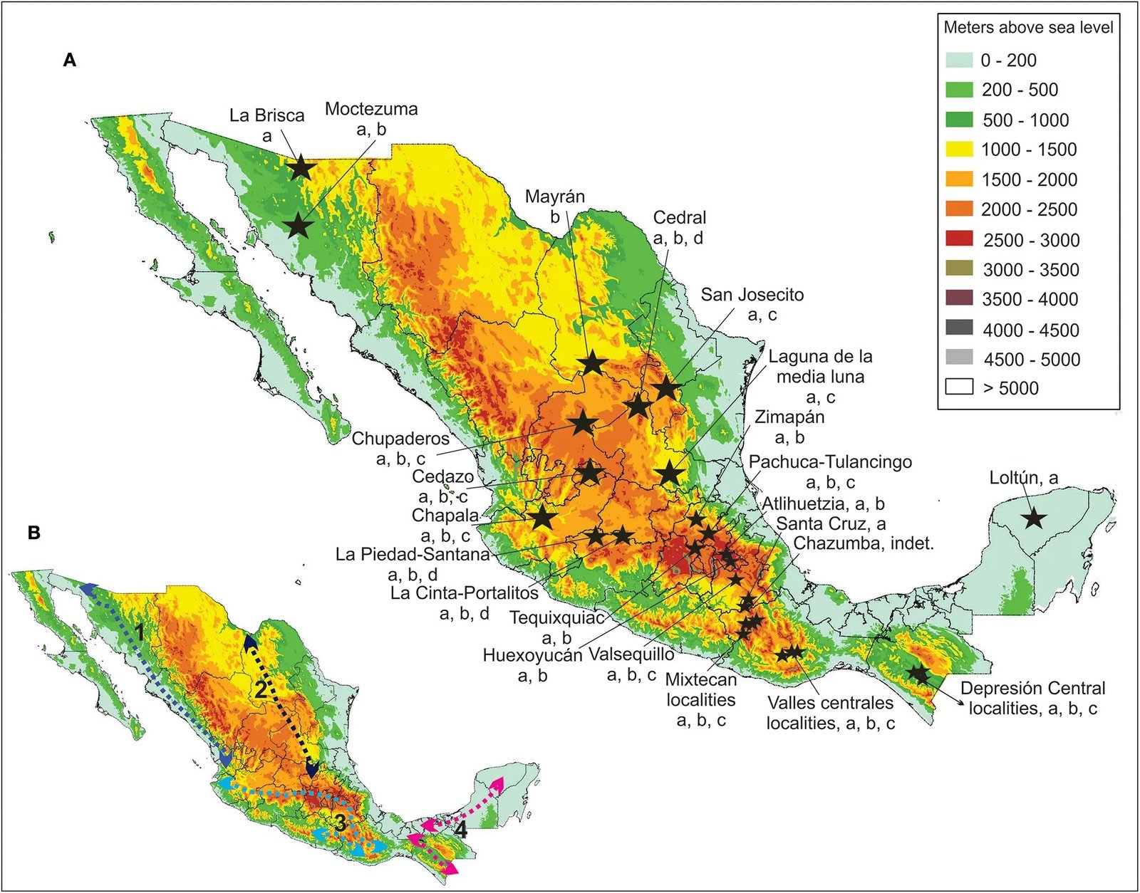
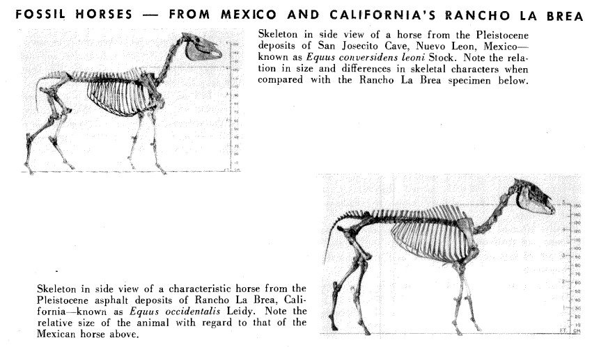
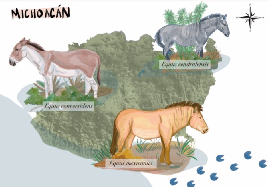


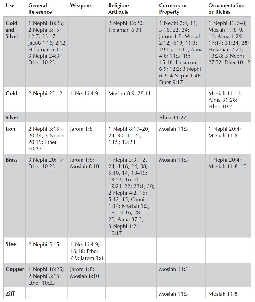
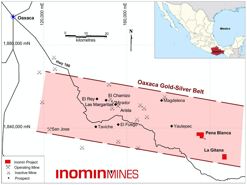
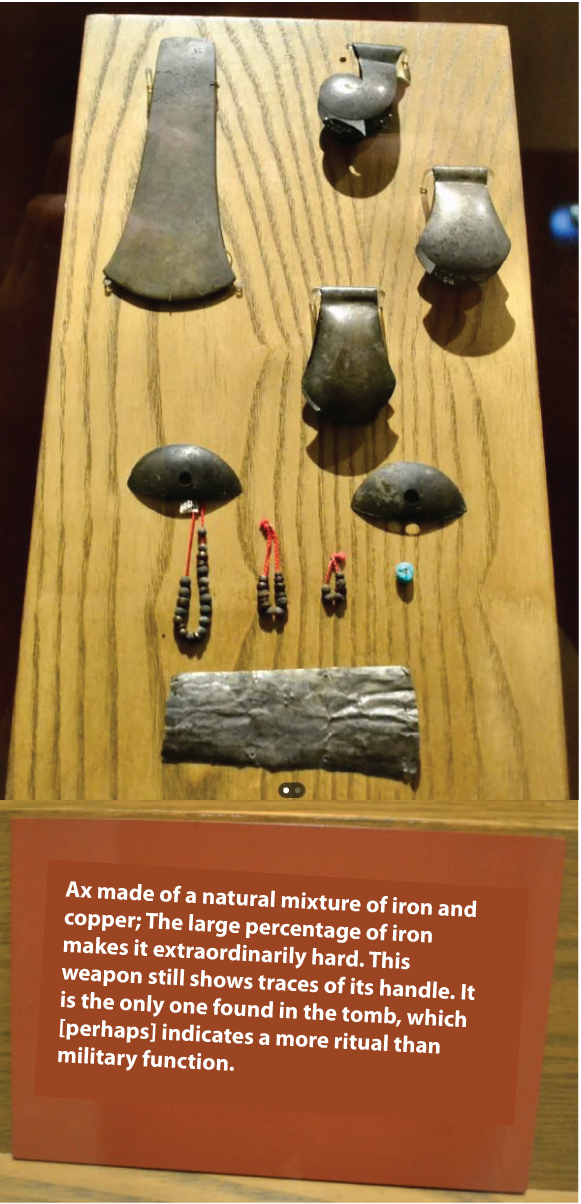
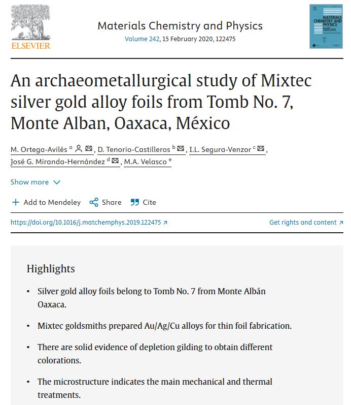
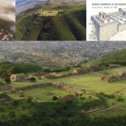
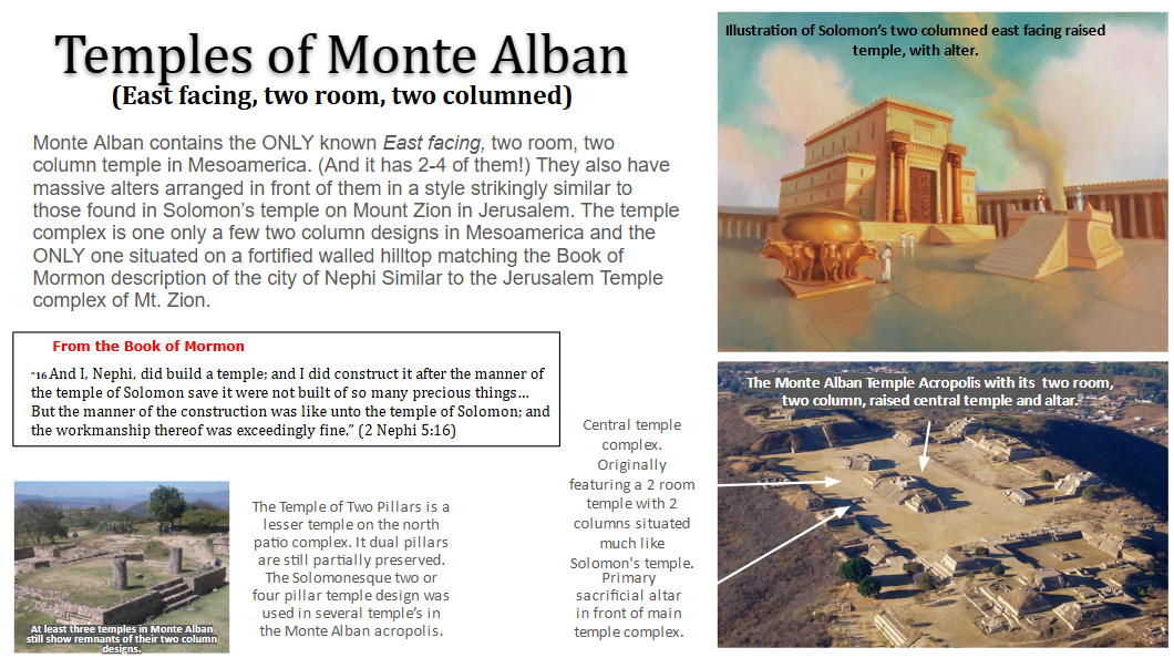
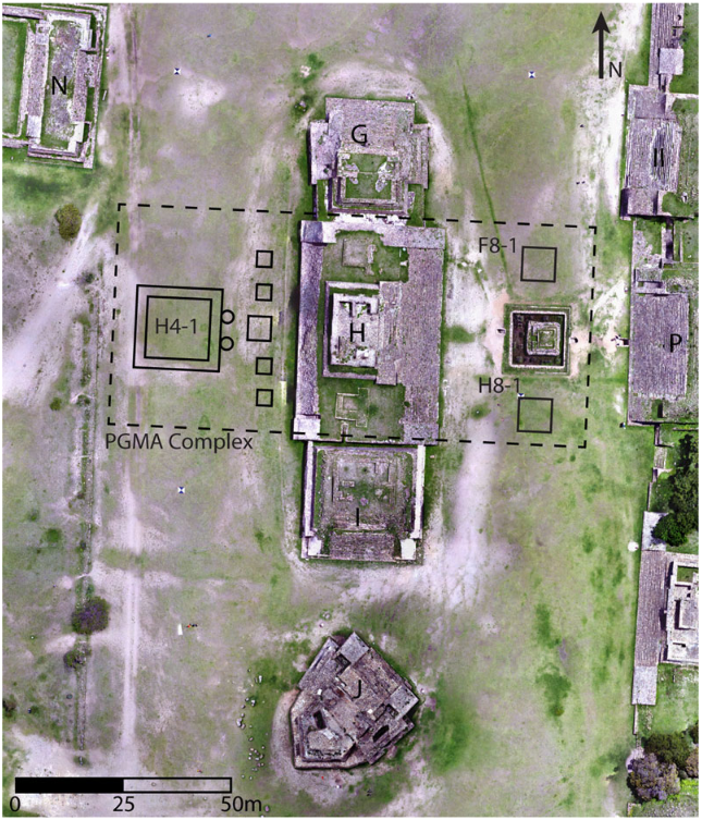
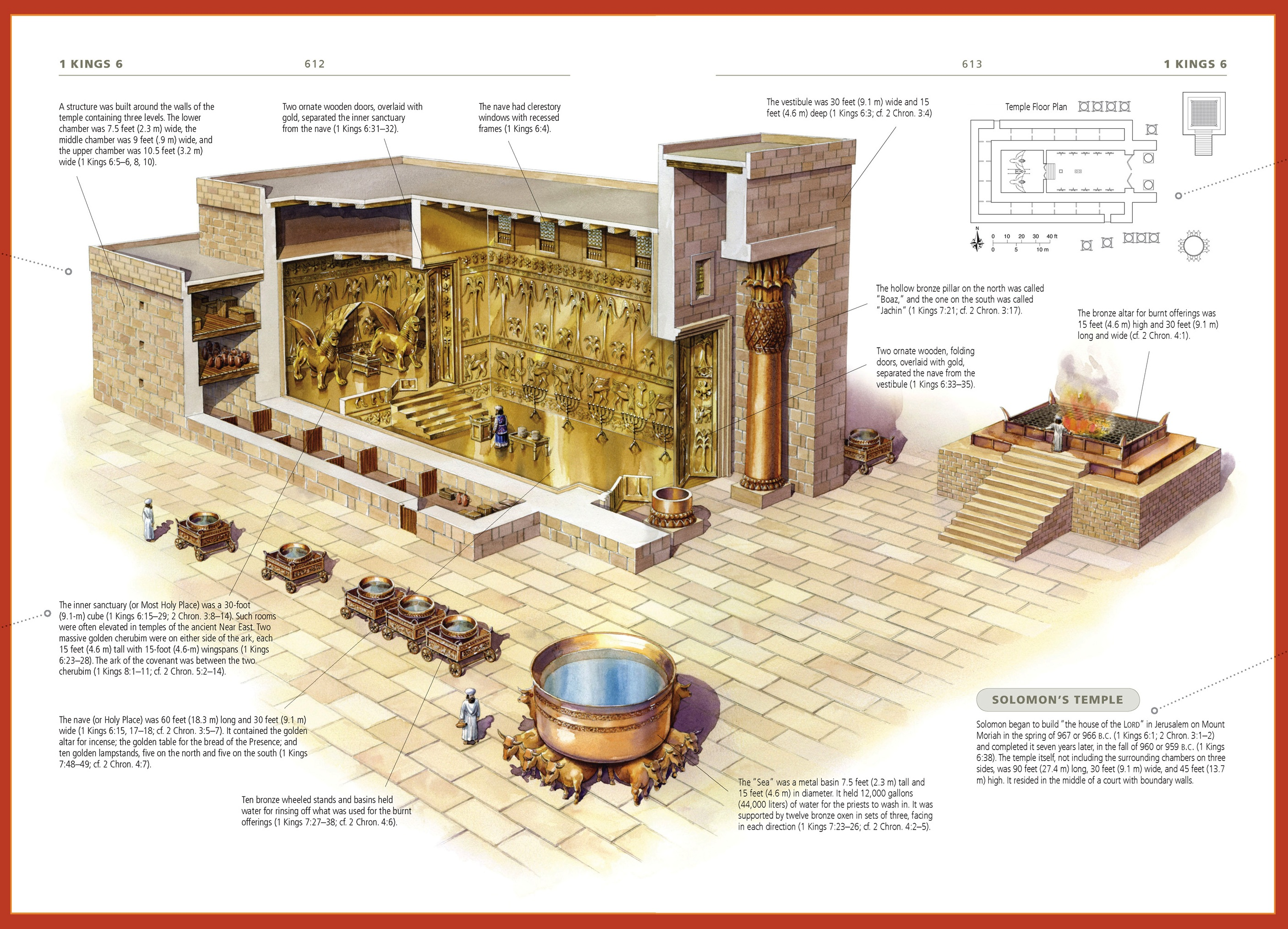

![[View the TL report]](http://www.unm.edu/~rhristov/TLTestReport.jpg)
.png)