Timeline Chronology for the Jaredite culture from the Book of Ether in the Book of Mormon. See link for general Bible timeline.
The Book of Mormon Jaredite King List gives only 7 exact dates (lifespans and reigns) for the Jaredite Chronology. The only real markers we have to build a working chronology from are firstly, the date of the “dearth” or famine and megafauna extinction given in the narrative of Heth Ether 9:30–34. It’s important to note that it’s well established that Mastodons and other megafauna went extinct in most of continental North America at about 11-8,000 BC and the paleoindians role in killing them off and eating them amidst a major climate event (as explained in Ether 9:30–34) is well documented in the archaeological record, so we must consider the possibility that if radiocarbon dates are not off (which they certainly may be for that period), then there is likely a large unknown break of thousands of years between the Jared to Heth, and the rest of the timeline.
Secondly, the last Jaredite date which can be placed somewhere between ~570 BC when the Old World Migrants arrived and ~180 BC when the move to Zarahemla took place. As with most “King Lists” found in the old world, the list suggests a direct father to son succession, even though large breaks in time are almost positively present. Comparison with Egyptian, Sumerian and Babylonian King Lists in the Old World suggests this practice of mistakenly inferring direct succession was common, as later rulers wished to prove political legitimacy based on genealogy. All dates and ages are complete conjecture and are based upon the notes and the handful of exact dates (about 7) marked in underlined bold. Jared is said to have lived during the time of the Bible’s Tower of Babel which a literal Biblical timeline puts very close to the time of Abraham. However, Babylonian and Akkadian records suggest that this event was a common aspect of mythical records as early as 4000 BC (radiocarbon dated histories anyway).
If we are to believe radiocarbon dates, and the Book of Mormon’s Ether account of Jaredite people’s pursuing and “eating all” (Ether 9:34) of the Mammoths, Mastodons and megafauna dying off in the “dearth” (presumably the Younger Dryas, Ether 9:30), then we should suggest the true date to whatever event actually spawned the Babel myth occurred sometime around C14 date of 14,000 BC. (Which actually matches fairly well for radiocarbon dated ruins of Jericho and Göbekli Tepe). The last Jaredite historian, Coriantumr lived sometime just before the time of King Mosiah in the Book of Mormon. See the genealogical table correlation chart to see agreement between this timeline and other biblical internal genealogies. Guessed life Spans and other dates on this chart (dates not in underlined bold) are made to approximately match the ages and dates of corresponding figures in the bible timeline.
Descendant of Jared
timeline-notes about life
Life Span
Age at sons birth
Reign
Saw sons reign
Age made king
Possible Year?
Scripture References for kings life…..
1
Jared
(TAKING AGES HERE FROM BIBLE FOR SIMILIAR DATES)
240?
180?
100?
–
Babel: Between 14k C14 dates & ~2000 BC bible dates.
year that Coriantumr would have been found by people of Zarahemla
320 BC?
Complete conjecture
Symbols:
* = born in fathers old age
^ = lived an exceedingly long time
Bold = exact date given in scripture
The reason behind the date for Coriantumr is that when the people of Lemhi sent a group out to find Zarahemla, and yet they overshot and found a land “covered with bones” and brought back the 24 plates. Well unburied bones disintegrate in a hundred years or so unless its very arid. Thus they must have found the land within a hundred years of when the battles occurred (Mosiah 21:25–28).
We know it happened a while before King Mosiah I, since the Mulekites brought the stone with the record of Coriantumr staying with them at that time..and spoke of it like it was a while back (Omni 1:20–22). This was some time before 130 BC.
King Limhi’s group went north about 121 B.C.
So perhaps around 130-250 BC. Or perhaps not. Placing absolute dates on the Jaredite chronology is largely conjecture.
correlation of all genealogical tables given in biblical/LDS scripture
https://gatheredin.one/wp-content/uploads/2010/11/history-correlation-chart.png5131176MormonBoxhttps://gatheredin.one/wp-content/uploads/2024/02/newest-logo-all-together.pngMormonBox2014-05-28 10:26:392023-01-27 19:35:37Book of Mormon Chronology: Jaredite Timeline
This page is a compilation of quotes directly attributed to Joseph Smith or in official publications of which he was chief editor before his death relative to the geography of the Book of Mormon. Non-direct quotes of Geographic information are included only when substantiating direct quotes.
From the available documented evidence it is apparent Joseph held a continental view of Book of Mormon Geography. Quotes by Joseph Smith or statements attributed to him point to a belief in four major areas of Book of Mormon happenings.
1- He believed the Lehites to have landed in South America
2- He believed them to have travelled to Central America to settle (with cities/lands like Zarahemla & Nephi being there).
3- He believed the the Land Desolation or where the Nephites ‘lost their power’ to be in the U.S. Southwest & Great Plains.
4- He believed Cumorah and the final battle to be in New York, and much of North America to be the Book of Mormon ‘Land Northward’ and/or Jaredite territory.
Currently, most LDS church Book of Mormon geography researchers are split between believing and disbelieving half of Joseph’s geographic model. With “Heartlanders” believing points 3 & 4 above and Mesoamericanists believing point 2 & possibly 1 above. And because of the Narrow Neck problem neither side can see eye to eye or believe ALL of Joseph Smith’s quotes. (See this article for information on the Narrow Neck problem, and its solution.)
And although it seems possible that Joseph Smith did not receive specific revelation pertaining to most specifics of where Book of Mormon events took place, when taken as a whole, the descriptions he gives of Book of Mormon locations are fairly consistent and seem to suggest a generalized knowledge of Book of Mormon lands. Some modern LDS scholars believe that Joseph learned the geography as time progressed or perhaps didn’t have a concrete idea in his mind about where it took place at all, however, quotes like the following from Joseph Smith himself and then another from Lucy Mack Smith as well as others contained in this document seem to suggest otherwise.
I was also informed [by the angel] concerning the aboriginal inhabitants of this country and shown [in vision?] who they were, and from whence they came; a brief sketch of their origin, progress, civilization, laws, governments, of their righteousness and iniquity, and the blessings of God being finally withdrawn from them as a people, was made known unto me; I was also told where were deposited some plates on which were engraven an abridgment of the records of the ancient Prophets that had existed on this continent. The angel appeared to me three times the same night and unfolded the same things. After having received many visits from the angels of God unfolding the majesty and glory of the events that should transpire in the last days, on the morning of the 22nd of September, A.D. 1827, the angel of the Lord delivered the records into my hands.
(Joseph Smith, Wentworth Letter. JS, History, 1838–1856, vol. C-1, created 24 Feb. 1845–3 July 1845; handwriting of Thomas Bullock, Franklin D. Richards, Jonathan Grimshaw, and Leo Hawkins; 512 pages. Original available here)
“During our evening conversations, Joseph would occasionally give us some of the most amusing recitals that could be imagined. He would describe the ancient inhabitants of this continent, their dress, mode of traveling, and the animals upon which they rode; their cities, their buildings, with every particular; their mode of warfare; and also their religious worship. This he would do with as much ease, seemingly, as if he had spent his whole life among them.”
(1) –Quotes Suggesting Joseph Believed the Lehites Crossed the South Pacific & Landed in Western South America.
Article from Time and Seasons while Joseph Smith was chief editor. The Lehites landed a bit south of the Isthmus of Darien (Which was an old name for Panama).
When we read in the Book of Mormon that Jared and his brother came on to this continent from the confusion and scattering at the Tower, and lived here more than a thousand years, and covered the whole continent from sea to sea, with towns and cities; and that Lehi went down by the Red Sea to the great Southern Ocean, and crossed over to this land, and landed a little south of the Isthmus of Darien, and improved the country according to the word of the Lord… Surely “facts are stubborn things.” It will be as it ever has been, the world will prove Joseph Smith a true prophet by circumstantial evidence, in experiments, as they did Moses and Elijah.
Note that, as shown in this 1835 New England publication, that although the term “Great Southern Ocean” or just “Southern Ocean” could be used interchangeably to refer to both the south Atlantic between south America & Africa—as well as the south Indian & Pacific oceans between south Africa (Cape Horn), Tasmania (Van Dieman’s Land), New Zealand, and south America (Cape of Good Hope), the logic of using the south Atlantic to land a boat, “a little south of the Isthmus of Darian” is unworkable. He is obviously here referring to the ‘Great South Sea’, as seen in the following maps. Payne-1798, Laurie-1800, Ortelius-1600s, Alzate-1768.
The above statement is supported by the following quote recorded by Frederick G. Williams and originally published in 1879 by Orson Pratt. Shows that Lehites landed in Chile, though of questionable authenticity and unknown origin, at least two separate individuals appear to have recorded it (although one could be based on the other, and the time of recording is decades after Joseph’s death). It is included only because it somewhat corroborates the Times & Seasons quote above of a South American first landing. (Even if other quotes suggest the Lehites then went up the coast to Mesoamerica before founding the cities of Nephi or Zarahemla)
They traveled nearly a south, southeast direction until they came to the nineteenth degree of north latitude; then, nearly east to the Sea of Arabia, then sailed in a southeast direction, and landed on the continent of South America, in Chile, thirty degrees south latitude.
Franklin D Richards & James Little, 1844 Publication. Attributed to ‘Joseph the Seer’. Similar quote also attributed to Frederick G. Williams as presented to Church history archives by Nancy Williams in 1860’s, suggestedly originating from J.S. speech at Kirtland Temple Dedication in 1836. (more information available here)
Some have questioned Joseph’s involvement or support of the Times & Season’s articles which support a South American landing & Mesoamerican settling of the Lehite group. However, this idea is likely unsupportable given the following evidence. In the Joseph Smith Papers, we have copies of the letter dictated to Wilford Woodruff sent to John Bernhisel and signed by Joseph Smith, to thank him for gifting him the copy of Stephen’s Incidents of Travels which were quoted by the Times & Seasons. He says in the letter SPECIFICALLY, the same statement as made in the Times & Seasons that the book, “supports the testimony of the Book of Mormon”.
.
Dear Sir I received your kind present [of Stephen’s Incidents of Travel in Central America] by the hand of E. Woodruff & feel myself under many obligations for this mark of your esteem & friendship which to me is the more interesting as it unfolds & developes many things that are of great importance to this generation & corresponds with & supports the testimony of the Book of Mormon; I have read the volumes with the greatest interest & pleasure & must say that of all histories that have been written pertaining to the antiquities of this country it is the most correct luminous & comprehensive…
Despite the above, some still protest that John Taylor or Wilford Woodruff may have written the The Times & Seasons extracts without Joseph’s knowledge, or approval of the content. However scholarship available here and statistical analysis suggests that Joseph Smith’s stylistic influence is the strongest of the three editors. His involvement in the publication of the above extracts of John Loyde Stephens
Additionally, Joseph Smith printed the below quote in March edition of the Times & Seasons just months before the editions most quotes on BOM geography come from. Indeed, given this evidence, nothing short of mental gymnastics can support the belief that Joseph Smith did not believe in a continental model of the Book of Mormon which included lands south of the United States.
“This paper commences my editorial career, I alone stand responsible for it, and shall do for all papers having my signature henceforward. I am not responsible for the publication, or arrangement of the former paper [before march 1842]; the matter did not come under my supervision. -JOSEPH SMITH”
(2) –Quotes suggesting Joseph believed the Lehites settled in Mesoamerica.
Article from Time and Seasons while edited by Joseph Smith re-quotes a Spanish Chronicler and seems to equate the Lehites or Mulekites with Toltec legends suggesting they founded the City of Tula in the Valley of Mexico.
Lehi went down by the Red Sea to the great Southern Ocean, and crossed over to this land… Now read Stephens’ story: “According to Fuentes, the chronicler of the kingdom of Guatumala, the kings of Quinche and Cachiquel were descended from the Toltecan Indians, who, when they came into this country, found it already inhabited by people of different nations. According to the manuscripts of Don Juan Torres, the grandson of the last king of the Quiches…the Toltecas themselves descended from the house of Israel, who were released by Moses from the tyranny of Pharaoh, and after crossing the Red Sea, fell into Idolatry. … and under the guidance of Tanub, their chief, passed from one continent to the other, to a place which they called the seven caverns, a part of the kingdom of Mexico, where they founded the celebrated city of Tula.”
Article from Time and Seasons while edited by Joseph Smith which contained a large portion from Stephen’s Incidents of Travel in Central America, Chiapas, and Yucatan. Shows that Lehites lived in Central America [Mesoamerica].
Let us turn our subject, however, to the Book of Mormon, where these wonderful ruins of Palenque are among the mighty works of the Nephites:-and the mystery is solved… On the 72d page of the third and fourth edition of the Book of Mormon it reads as follows: And it came to pass that we began to prosper exceedingly, and to multiply in the land. And I, Nephi, did take the sword of Laban, and after the manner of it did make many swords, lest by any means the people who were now called Lamanites, should come upon us and destroy us: for I knew their hatred towards me and my children, and those who were called my people. And I did teach my people, to build buildings: and to work in all manner of wood, and of iron, and of copper, and of brass, and of steel, and of gold, and of silver, and of precious ores, which were in great abundance. And I, Nephi, did build a temple; [ie. the City of Nephi] and I did construct it after the manner of the temple of Solomon, save it were not built of so many precious things: for they were not to be found upon the land; wherefore, it could not be built like un-to Solomon’s temple. But the manner of the construction was like unto the temple of Solomon; and the workmanship thereof was exceeding fine. And on page 280-1 is a full description of the Isthmus.
Mr. Stephens’ great developments of antiquities are made bare to the eyes of all the people by reading the history of the Nephites in the Book of Mormon. They lived about the narrow neck of land, which now embraces Central America [ie. Mesoamerica], with all the cities that can be found. Read the destruction of cities at the crucifixion of Christ, pages 459-60. Who could have dreamed that twelve years would have developed such incontrovertible testimony to the Book of Mormon? surely the Lord worketh and none can hinder.
Article from Time and Seasons while edited by Joseph Smith as a follow-up to the above quote. Shows that Lehites lived in Central America. Importantly it casts great doubt upon the idea that Joseph Smith ever believed the modern Mormon city of Zarahemla Iowa was actually the spot that the ancient city of Zarahemla in the Book of Mormon stood.
Since our ‘Extract’ was published from Mr. Stephens’ ‘Incidents of Travel,’ &c., we have found another important fact relating to the truth of the Book of Mormon. Central America, or Guatemala, is situated north of the Isthmus of Darien and once embraced several hundred miles of territory from north to south.-The city of Zarahemla, burnt at the crucifixion of the Savior, and rebuilt afterwards, stood upon this land as will be seen from the following words in the book of Alma:-‘And now it was only the distance of a day and a half’s journey for a Nephite, on the line Bountiful,and the land Desolation, from the east to the west sea; and thus the land of Nephi, and the land of Zarahemla was nearly surrounded by water: there being a small neck of land between the land northward and the land southward.’ [See Book of Mormon 3d edition, p. 280-81.]
It is certainly a good thing for the excellency and veracity, of the divine authenticity of the Book of Mormon, that the ruins of Zarahemla have been found where the Nephites left them: and that a large stone with engravings upon it, as Mosiah said; and a ‘large round stone, with the sides sculptured in hieroglyphics,’ as Mr. Stephens has published, is also among the left remembrances of the, (to him,) lost and unknown. We are not going to declare positively that the ruins of Quirigua are those of Zarahemla, but when the land and the stones, and the books tell the story so plain, we are of opinion, that it would require more proof than the Jews could bring to prove the disciples stole the body of Jesus from the tomb, to prove that the ruins of the city in question, are not one of those referred to in the Book of Mormon.
It may seem hard for unbelievers in the mighty works of God, to give credit to such a miraculous preservation of the remains, ruins, records and reminiscences of a branch of the house of Israel: but the elements are eternal, and intelligence is eternal, and God is eternal, so that the very hairs of our heads are all numbered. It may be said of man he was and is, and is not; and of his works the same, but the Lord was and is, and is to come and his works never end; and he will bring every thing into judgment whether it be good, or whether it be evil; yea, every secret thing, and they shall be revealed upon the house tops. It will not be a bad plan to compare Mr. Stephens’ ruined cities with those in the Book of Mormon: light cleaves to light, and facts are supported by facts. The truth injures no one, and so we make another
(3) –Quotes suggesting the Nephite Land of Desolation stretched from the Great Plains to the Desert Southwest where the Nephites ‘lost their power’.
Mosiah Hancock recorded a first hand conversation he had with Joseph Smith saying that the Nephites lost their power in the Southwestern United States or Northmost Mexico. Mosiah would have been ten years old when Joseph was murdered, although his biographical descriptions of that year seem to be quite vivid, and this quote is included because it is corroborated not only by his father Levi Hancock (who was a close confidant of Joseph) as well as the other quotes below, such as Willium McBride’s quote and “Moroni’s Travels” maps, but also by Joseph’s direct quote to Emma equating Zion’s Camp with the “plains of the Nephites”, and Zelph’s death “during the last great struggle of the Lamanites and Nephites.”
“Now”, [Joseph] said, “I will show you the travels of this people”. He then showed our travels through Iowa, and said, “Here you will make a place for the winter; and here you will travel west until you come to the valley of the Great Salt Lake! You will build cities to the North and to the South, and to the East and to the West… But, the United States will not receive you with the laws which God desires you to live, and you will have to go to where the Nephites lost their power... placing his finger on the map, I should think about where Snowflake, Arizona is situated, or it could have been [north most] Mexico
“Nothing occurred of any account until we got in Illinois when Joseph said, in our tent, “I want you to remember what I say to you. The Lord is going to give us dry weather now until we get through. He has given rains that there might be water on the prairies. You will see the movings of the Lord in our favor all the way through.” It began to be very pleasant and soon we entered on the wide prairies camping and holding meetings on Sunday…
…On the way to Illinois River where we camped on the west side. In the morning many went to see the big mound about a mile below the crossing. I did not go on it but saw some bones that were brought back with a broken arrow. They were laid down by our camp. Joseph Smith addressing himself to Sylvester Smith and said, “This is what I told you and now I want to tell you that you may know what I meant. This land was called the land of desolation and Onedages was the King and a good man was he. There in that mound did he bury his dead and did not dig holes as the people do now, but they brought their dirt and covered them until you see they have raised it to be about one hundred feet high. The last man buried was Zelf or Telf. He was a white Lamanite who fought with the people of Onedagus for freedom….” These words he said as the camp was moving off the mounds as near as I could learn he had told them something about the mound and got them to go and see it for themselves. I then remembered what he had said a few days before while passing many mounds on our way …”
From W.W. Phelps who echoes Levi Hancock. Although he does not directly attribute this information to Joseph Smith it corroborates both the Hancock’s and Times and Season’s articles which place the Jaredites in North America stretching ‘from sea to sea’.
What the design of our heavenly Father was or is, as to these vast prairies of the far west, I know no farther than we have revelation. The book of Mormon terms them [the prairies] the land of desolation, and when I get into a prairie so large that I am out of sight of timber, just as a seaman is “out of sight of land in the ocean,” I have to exclaim, what is man and his works, compared to the Almighty and his creations? Who hath viewed his everlasting fields? Who hath counted his buffaloes;—who hath seen all his deer, on a thousand prairies? Well may his sacred word declare:—The cattle upon a thousand hills are mind. All are God’s…
W. Phelps. To O. Cowdery, Esq.” (MESSENGER AND ADVOCATE, Vol. 2, July, 1836, No. 22, pg. 341 – emphasis added)
More from WW. Phelps associating the desolate prairies of the Midwest with desolation. .
THE far west, as the section of country from the Mississippi to the Rocky Mountains may justly be styled, is not only distant from the Atlantic States, but different. Its principal river, running rapidly from the 48th to the 39th degree of north latitude, is always rily, always wearing away its banks and always making new channels: It is rightly named Missouri; for in plain English, it looks like the waters of misery,—or troubled water:—even as the sea which the prophet said, Casts up mire and dirt. With the exception of the skirts of timber upon the streams of water, this region of country is one continued field, or prairie, (as the French have it, meaning meadows,) and there is something ancient as well as grand about it, too; for while the eye takes in a large scope of clear field, or extensive plains, decorated with here and there a patch of timber, like the orchards which beautify the farms in the east, the mind goes back to the day, when the Jaredites were in their glory upon this choice land above all others, and comes on till they, and even the Nephites, were destroyed for their wickedness: Here pause and look to the east, and read the words of the prophet: Wo to the crown of pride, to the drunkards of Ephraim, whose glorious beauty is a fading flower, which is on the head of the fat valleys of them that are overcome with wine! Behold, the Lord hath a mighty and strong one, which as a tempest of hail and a destroying storm, as a flood of mighty waters overflowing, shall cast down to the earth with the hand.—The crown of pride, the drunkards of Ephraim, shall be trodden under feet: and the glorious beauty, which is on the head of the fat valley, shall be a fading flower, and as the hasty fruit before the summer; which when he that looketh upon it seeth, while it is yet in his hand he eateth it up. In that day shall the Lord of hosts be for a crown of glory, and for a diadem of beauty, unto the residue of his people, and for a spirit of judgment to him that sitteth in judgment, and for strength to them that turn the battle to the gate.
To return: this beautiful region of country is now mostly, excepting Arkansas and Missouri, the land of Joseph or the Indians, as they are called, and embraces three fine climates: First, like that of New-York; second, like Missouri, neither northern nor southern; and third, like the Carolinas. This place may be called the centre of America; it being about an equal distance from Maine, to Nootka sound; and from the gulf of St. Lawrence to the gulf of California; yea, and about the middle of the continent from cape Horn, south, to the head land at Baffin’s Bay, north. The world will never value the land of Desolation, as it is called in the book of Mormon, for any thing more than hunting ground, for want of timber and mill-seats: The Lord to the contrary notwithstanding, declares it to be the land of Zion which is the land of Joseph, blessed by him, for the precious things of heaven, for the dew, and for the deep that coucheth beneath, and for the precious fruits brought forth by the sun, and for the precious things put forth by the moon, and for the chief things of the ancient mountains, and for the precious things of the lasting hills, and for the precious things of the earth and fulness thereof, and for the good will of him that dwelt in the bush: let the blessing come upon the head of Joseph, and upon the top of the head of him that was separated from his brethren. His glory is like the firstling of his bullock, and his horns are like the horns of unicorns: with them he shall push the people together from the ends of the earth: and they are the ten thousands of Ephraim, and they are the thousands of Manasseh.
Although the Zarahemla area of Orson Pratt’s geographic model conflicts with Joseph’s, and changed over time, Orson’s views on the Jaredite lands stood firm in placing Jaredite Desolation (as ‘Moron’ or the land of inheritance per Ether 7:5–6) just south of the Gulf of California (Mazatlán area). Fittingly with Joseph’s continental model, Orson also believed Omer fled from Desolation near the Gulf of California to the New England coast near his ‘Cumorah’ (in New York).
The [Jaredites] navigated the great Pacific ocean. …taking eight barges, launched on the eastern coast of China, and bringing them a voyage of three hundred and forty-four days and landing them… to the south of this, just below the Gulf of California, on our western coast. They inhabited North America, and spread forth on this Continent, and in the course of some sixteen hundred years’ residence here, they became a mighty and powerful nation…
Omer and his family and some few of his friends, that were righteous enough to be spared out of a whole nation. The Lord warned them by a dream to depart from the land of Moran [Moron: see Ether 7:6], and led them forth in an easterly direction beyond the hill Cumorah, down into the eastern countries upon the sea shore. By this means a few families were saved, while all the balance, consisting of millions of people, were overthrown because of their wickedness. But after they were destroyed the Omerites, who dwelt in the New England States, returned again and dwelt in the land of their fathers on the western coast.
TWO SEPERATE MAPS found in the Church archives and attributed to William McBride (1807-1895) and Andrew M. Hamilton (1809-1894) of Richfield, Utah with the text “got it from Joseph Smith the Prophet” written on it (H. Peterson, 1995) corroborate the above quotes. They closely echo the first Mosiah Hancock quote, by detailing the travels of Moroni “starting in Central America” (see also text on second map). These maps were likely part of the narrative told throughout Southern Utah in the 1880’s by Joseph Smith’s contemporaries concerning his prophesies of the Saints future travels and how they would mirror those of the ancient Nephites.
William McBride is recorded giving a detailed explanation of what’s recorded on the maps, at a St George temple prayer meeting in 1881. Charles Lowell records the third hand words of Joseph Smith in his journal,
Br McBride also related that Joseph marked with his cane in the sand the track the saints would take to the Rocky Mountains. Says Joseph, will you establish the kingdom there? No, but it will be set up and the saints will live their covenants, meaning the Marriage covenant. Said we should travel on thro the mountains; described the Valley of Great Salt Lake just as tho he had lived there, designating where the soldiers camp would be and the burying ground.
Said we should make stations and build up settlements all the way to New and Old Mexico until we crossed the Isthmus and get back to the place where the Covenant was broke [ie. United Order] by the old Nephites. Spoke of the Great Temple in Central America unfinished… This temple was situated by the River Copan anciently called the River of Nephi…
Spoke of the route THE OLD NEPHITES TOOK travelling to Cumorah from the South and Southwest; of having to bury their treasures as they journeyed and finally burying the records and precious things in the Hill Cumorah; of Moroni dedicating the Temple site of what we now call St George, Nauvoo, Jackson Co., Kirtland and others we know not of as yet.
Although there is ambiguity in the above quote as to whether “the old Nephites,” Lowell/McBride were referring to was the whole of the Nephite people or a few survivors with Moroni (as possibly suggested by a Brigham Young quote given around the same date), we will demonstrate later in this paper that Joseph Smith most certainly believed the entire Nephite nation met it’s end in upstate New York.
Again, the maps, when combined with Mosiah Hancock’s quote which shares similar verbiage, suggest that the Saints travels out west from New York were a sort of reverse migration from the travels of Moroni and the whole of the Nephite people on their way to Cumorah (which is labeled in New York). A bit more information can be found at this link.
The next day the Prophet came to our home and stopped in our carpenter shop and stood by the turning lathe. I went and got my map for him. “Now”, he said, “I will show you the travels of this people”. He then showed our travels through Iowa, and said, “Here you will make a place for the winter; and here you will travel west until you come to the valley of the Great Salt Lake! You will build cities to the North and to the South, and to the East and to the West; and you will become a great and wealthy people in that land. …But, the United States will not receive you with the laws which God desires you to live, and you will have to go to where the Nephites lost their power. [The Nephites] worked in the United Order for 166 years, and the Saints have got to become proficient in the laws of God before they can meet the Lord Jesus Christ… He said we will not travel the shape of the horse shoe [see map] for there we will await the action of the government. Placing his finger on the map, I should think about where Snowflake, Arizona is situated, or it could have been [north most] Mexico, he said, “The government will not receive you with the laws that God designed you to live, and those who are desirous to live the laws of God will have to go South…” [presumably into the Mormon Colonies of Northern Mexico]
(Mosiah Hancock, Autobiography, BYU Special Collections, Writings of Early Latter-day Saints 28. Original is here
Before dismissing the quotes just given as too late in time from Joseph Smith to be trusted, it’s worth noting that the Nephite migration in the above quotes are not only supported by overwhelming archaeological evidence as presented in the Mexican Highland model, but quite possibly by linguistic evidence of the Uto-Azteca language group as well as general geography matching Book of Mormon land descriptors. In this model the Semitic similarities demonstrated by Brian Stubbs between Uto-Aztecan & Semitic languages would have been first established by the Jaredites who landed in California or Sonora Mexico, and then reinforced by Nephites who later began to migrate into those same regions of Desolation (the Jaredite heartland), and the land Northward. The works of early native chronicler Ixtlilxochitl are also of note.
Although not in any way attributed to Joseph Smith, and in fact in direct contradiction to quotes that are attributed to Joseph Smith when it comes to the location of Desolation, the following quote by Parly P. Pratt given in 1842 helps show that even before the death of the Prophet a number of the Saints were in agreement in holding John Loyyd Stephens Mesoamerican ruins of Quirigua, Copan, Tonina, Uxmal, and Palenque as Book of Mormon cities. (Desolation cities in the minds of both Parley P Pratt & Orson Pratt.)
I say it is remarkable that Mr. Smith, in translating the Book of Mormon from 1827 to 1830, should mention the names and circumstances of those towns and fortifications in this very section of country, where a Mr. Stephens, ten years afterwards, penetrated a dense forest, till then unexplored by modern travelers, and actually finds the ruins of those very cities mentioned by Mormon. The nameless nation of which he speaks were the Nephites. The lost record for which he mourns is the Book of Mormon. The architects, orators, statesmen, and generals, whose works and monuments he admires, are, Alma, Moroni, Helaman, Nephi, Mormon, and their contemporaries. The very cities whose ruins are in his estimation without a name, are called in the Book of Mormon, “Teancum, Boaz, Jordan, Desolation,” &c.
Parley P. Pratt, “Ruins in Central America,” Millennial Star, March 1842, 165. (source link)
(4) –Quotes suggesting Joseph believed Cumorah and the final battle to be in New York, and much of North America to be the Book of Mormon ‘Land Northward’.
An epistle from Joseph Smith the Prophet to The Church of Jesus Christ of Latter-day Saints, dated at Nauvoo, Illinois, September 6, 1842. Shows explicitly that Joseph believed the location where Moroni appeared before giving him the plates was Cumorah.
Now, what do we hear in the gospel which we have received? A voice of gladness! A voice of mercy from heaven; and a voice of truth out of the earth; glad tidings for the dead; a voice of gladness for the living and the dead; glad tidings of great joy. How beautiful upon the mountains are the feet of those that bring glad tidings of good things, and that say unto Zion: Behold, thy God reigneth! As the dews of Carmel, so shall the knowledge of God descend upon them!
And again, what do we hear? Glad tidings from Cumorah!Moroni, an angel from heaven, declaring the fulfilment of the prophets-the book to be revealed. A voice of the Lord in the wilderness of Fayette, Seneca county, declaring the three witnesses to bear record of the book! The voice of Michael on the banks of the Susquehanna, detecting the devil when he appeared as an angel of light! The voice of Peter, James, and John in the wilderness between Harmony, Susquehanna county, and Colesville, Broome county, on the Susquehanna river, declaring themselves as possessing the keys of the kingdom, and of the dispensation of the fulness of times! (D&C 128:19–20)
Joseph & Oliver also said the following in a letter to W.W. Phelps,
“You are acquainted with the mail road from Palmyra… At about one mile west rises another ridge of less height, running parallel with the former, leaving a beautiful vale between. The soil is of the first quality for the country, and under a state of cultivation, which gives a prospect at once imposing, when one reflects on the fact, that here, between these hills, the entire power and national strength of both the Jaredites and Nephites were destroyed. By turning to the 529th and 530th pages of the book of Mormon you will read Mormon’s account of the last great struggle of his people, as they were encamped round this hill Cumorah”
In 1856 Heber C. Kimball gave a talk in which he gave suggested first or possibly second hand information about a vision that “Joseph [Smith] and others had” concerning the Hill Cumorah in New York. This vision gave information to them about a cave in which was stored “all the sacred engravings” or as was seen in this vision, “more records than ten men could carry”.
“…the vision that Joseph [Smith] and others had, when into a cave in the hill Cumorah, and saw more records than ten men could carry…. There were books piled up on tables, book upon book. …they are events that I heard Joseph speak of, time and time again.
This experience is shared by at least 9 different individuals, who heard about, mostly second hand. Although all the quotes are of a late date they at least seem to corroborate the general experience even though they vary on important details such as 1. who was there, 2, whether the experience was objective or a subjective visionary experience, and 3, what exactly was in the cave. For all 9 or 10 accounts see Cumorah’s Cave by Cameron j. Packer or this article on supportingevidences.net
In this article we offer two more quotes because one tells who might have been there, and the other is a first hand source by one of those individuals. The first by William Horne Dame, 1819-1884, was written in his Diary dated, 14 January 1855.
“Attended meeting a discourse from W. W. Phelps. He related a story told him by Hyrum Smith which was as follows: Joseph, Hyrum, Cowdery & Whitmere went to the hill Cormorah. As they were walking up the hill, a door opened and they walked into a room about 16 ft square. In that room was an angel and a trunk. On that trunk lay a book of Mormon & gold plates, Laban’s sword, Aaron’s brestplate.” (William Horne Dame Diary, 14 January 1855)
The second quote was recorded incredibly late (at least 50 years later) in 16 August 1878, by Whitmer himself speaks about the record cave of Cumorah, as if he had intimate knowledge of it, but not saying specifically that he had been there, in an interview with P. Wilhelm Poulson of the Deseret News:
Poulson: Where are the plates now? Whitmer: In a cave, where the angel has hidden them up till the time arrives when the plates, which are sealed, shall be translated. God will yet raise up a mighty one, who shall do his work till it is finished and Jesus comes again. Poulson: Where is that cave? Whitmer: In the State of New York. Poulson: In the Hill of Comorah? Whitmer: No, but not far away from that place. (John Whitmer. Deseret Evening News, August 16, 1878. See more info here)
Recollections of a conversation with Joseph Smith by his mother, Lucy Mack Smith. Shows that the Hill Cumorah was in the New York area.
The fact was I had learned to be a little cautious about matters with regard to Joseph, for I was accustomed to see him look as he did on that occasion and I could not easily mistake the cause thereof.
Presently he smiled and said in a calm tone, “I have taken the severest chastisement that I have ever had in my life.”
My husband, supposing that it was from some of the neighbors, was quite angry and observed, “I would like to know what business anybody has to find fault with you!” “Stop, father, stop,” said Joseph, “it was the angel of the Lord. As I passed by the hill of Cumorah, where the plates are, the angel met me and said that I had not been engaged enough in the work of the Lord; that the time had come for the record to be brought forth; and that I must be up and doing and set myself about the things which God had commanded me to do. But, father, give yourself no uneasiness concerning the reprimand which I have received, for I now know the course that I am to pursue, so all will be well.”
It was also made known to him at this interview that he should make another effort to obtain the plates, on the twenty-second of the following September, but this he did not mention to us at that time.
Remember that the Book of Mormon explicitly states that the final Battle happened around the Hill Cumorah and that the location where “all the records” were hid was called the Hill Cumorah. So to suggest the revelation of D&C 128:20 and that in the above quotes are not the same as the hill mentioned in the Book of Mormon, is to suggest there are TWO Hill Cumorahs, and that Joseph was deeply mistaken and that the D&C 128 revelation/letter was not specifically inspired in regard to the name of the location therein referred.
2 And I, Mormon, wrote an epistle unto the king of the Lamanites, and desired of him that he would grant unto us that we might gather together our people unto the land of Cumorah, by a hill which was called Cumorah, and there we could give them battle. 6 And it came to pass that when we had gathered in all our people in one to the land of Cumorah, behold I, Mormon, began to be old; and knowing it to be the last struggle of my people, and having been commanded of the Lord that I should not suffer the records which had been handed down by our fathers, which were sacred, to fall into the hands of the Lamanites, (for the Lamanites would destroy them) therefore I made this record out of the plates of Nephi, and hid up in the hill Cumorah all the records which had been entrusted to me by the hand of the Lord, save it were these few plates which I gave unto my son Moroni. (Mormon 6:2,6)
.
(5) – Quotes Concerning Nephites/Lamanites Living in the United States Region & Central US Natives Being Descendants of the Book of Mormon Peoples
Joseph Smith specifically stated the Book of Mormon was written by the forefathers of the western tribes (likely referring to the Natives west of Nauvoo, which included the Cherokee and natives relocated in the Indian Removal Act to Oklahoma territory in the 1830’s). Note he does not say the tribes of the East or South or Mexico, but particular singles out those of the West.
The Book of Mormon is a record of the forefathers of our western Tribes of Indians, having been found through the ministration of an holy Angel translated into our own Language by the gift and power of God, after having been hid up in the earth for the last fourteen hundred years31 containing the word of God, which was delivered unto them, By it we learn that our western tribes of Indians are desendants from that Joseph that was sold into Egypt, and that the Land of America is a promised land unto them,32 and unto it all the tribes of Israel will come. with as many of the gentiles as shall comply with the requesitions of the new co[v]enant.
From the Wentworth Letter–shows that Moroni instructed Joseph on many aspects relating to Book of Mormon geography.
On the evening on the 21st of September, A.D. 1823, while I was praying unto God, and endeavoring to exercise faith in the precious promises of Scripture, on a sudden a light like that of day, only of a far purer and more glorious appearance and brightness, burst into the room, indeed the first sight was as though the house was filled with consuming fire; the appearance produced a shock that affected the whole body; in a moment a personage stood before me surrounded with a glory yet greater than that with which I was already surrounded. This messenger proclaimed himself to be an angel of God, sent to bring the joyful tidings that the covenant which God made with ancient Israel was at hand to be fulfilled, that the preparatory work for the second coming of the Messiah was speedily to commence; that the time was at hand for the Gospel in all its fullness to be preached in power, unto all nations that a people might be prepared for the Millennial reign. I was informed that I was chosen to be an instrument in the hands of God to bring about some of His purposes in this glorious dispensation.
I was also informed concerning the aboriginal inhabitants of this country and shown who they were, and from whence they came; a brief sketch of their origin, progress, civilization, laws, governments, of their righteousness and iniquity, and the blessings of God being finally withdrawn from them as a people, was made known unto me; I was also told where were deposited some plates on which were engraven an abridgment of the records of the ancient Prophets that had existed on this continent. The angel appeared to me three times the same night and unfolded the same things. After having received many visits from the angels of God unfolding the majesty and glory of the events that should transpire in the last days, on the morning of the 22nd of September, A.D. 1827, the angel of the Lord delivered the records into my hands.
…In this important and interesting book the history of ancient America is unfolded, from its first settlement by a colony that came from the Tower of Babel, at the confusion of languages to the beginning of the fifth century of the Christian Era. We are informed by these records that America in ancient times has been inhabited by two distinct races of people. The first were called Jaredites, and came directly from the Tower of Babel. The second race came directly from the city of Jerusalem, about six hundred years before Christ. They were principally Israelites, of the descendants of Joseph. The Jaredites were destroyed about the time that the Israelites came from Jerusalem, who succeeded them in the inheritance of the country. The principal nation of the second race fell in battle towards the close of the fourth century. The remnant are the Indians that now inhabit this country. This book also tells us that our Savior made His appearance upon this continent after His resurrection; that He planted the Gospel here in all its fulness, and richness, and power, and blessing; that they had Apostles, Prophets, Pastors, Teachers, and Evangelists; the same order, the same priesthood, the same ordinances, gifts, powers, and blessings, as were enjoyed on the eastern continent, that the people were cut off in consequence of their transgressions, that the last of their prophets who existed among them was commanded to write an abridgment of their prophecies, history, &c, and to hide it up in the earth, and that it should come forth and be united with the Bible for the accomplishment of the purposes of God in the last days. For a more particular account I would refer to the Book of Mormon, which can be purchased at Nauvoo, or from any of our Traveling Elders.
(Joseph Smith. Wentworth Letter. JS, History, 1838–1856, vol. C-1, created 24 Feb. 1845–3 July 1845; handwriting of Thomas Bullock, Franklin D. Richards, Jonathan Grimshaw, and Leo Hawkins; 512 pages. Original available here)
Revelation given through Joseph Smith the Prophet to Oliver Cowdery, at Fayette, New York, September 1830. Calls Native Americans in North Central America “Lamanites.”
And now, behold, I say unto you that you shall go unto the Lamanites and preach my gospel unto them; and inasmuch as they receive thy teachings thou shalt cause my church to be established among them; and thou shalt have revelations, but write them not by way of commandment.
And now, behold, I say unto you that it is not revealed, and no man knoweth where the city Zion shall be built, but it shall be given hereafter. Behold, I say unto you that it shall be on the borders by the Lamanites. [of the Kansas/Oklahoma Territory, relocated there in 1830, see this link](D&C 28:8–9)
Revelation given through Joseph Smith the Prophet to Parley P. Pratt and Ziba Peterson, October 1830. Calls Native Americans in North Central America “Lamanites.”
And that which I have appointed unto him is that he shall go with my servants, Oliver Cowdery and Peter Whitmer, Jun., into the wilderness among the Lamanites. [of the Kansas/Oklahoma Territory, relocated there in 1830, see this link](D&C 32:2)
Revelation given through Joseph Smith the Prophet to Newel Knight, at Kirtland, Ohio, June 1831. Calls Native Americans in North Central America “Lamanites.”
And thus you shall take your journey into the regions westward, unto the land of Missouri, unto the borders of the Lamanites. [of the Kansas/Oklahoma Territory, relocated there in 1830, see this link](D&C 54:8)
Entry in The History of the Church showing that Nephites and Lamanites lived in the Illinois area (where Joseph Smith was traveling with Zion’s Camp).
During our travels we visited several of the mounds which had been thrown up by the ancient inhabitants of this country-Nephites, Lamanites, etc., and this morning I went up on a high mound, near the river, accompanied by the brethren. From this mound we could overlook the tops of the trees and view the prairie on each side of the river as far as our vision could extend, and the scenery was truly delightful.
On the top of the mound were stones which presented the appearance of three altars having been erected one above the other, according to the ancient order; and the remains of bones were strewn over the surface of the ground. The brethren procured a shovel and a hoe, and removing the earth to the depth of about one foot, discovered the skeleton of a man, almost entire, and between his ribs the stone point of a Lamanitish arrow, which evidently produced his death. Elder Burr Riggs retained the arrow. The contemplation of the scenery around us produced peculiar sensations in our bosoms; and subsequently the visions of the past being opened to my understanding by the Spirit of the Almighty, I discovered that the person whose skeleton was before us was a white Lamanite, a large, thick-set man, and a man of God. His name was Zelph. He was a warrior and chieftain under the great prophet Onandagus, who was known from the Hill Cumorah, or eastern sea to the Rocky mountains. The curse was taken from Zelph, or, at least, in part-one of his thigh bones was broken by a stone flung from a sling, while in battle, years before his death. He was killed in battle by the arrow found among his ribs, during the last great struggle of the Lamanites and Nephites.
Apparently assembled from the accounts of Heber C Kimball & Wilford Woodruff. Joseph Smith, History of The Church of Jesus Christ of Latter-day Saints, 7 vols., introduction and notes by B. H. Roberts [Salt Lake City: The Church of Jesus Christ of Latter-day Saints, 1932-1951], 2: 79 – 80
Entry in The History of the Church showing that Nephites and Lamanites lived near Adam-ondi-Ahman in North Central America.
Saturday, 19.-This morning we struck our tents and formed a line of march, crossing Grand River at the mouth of Honey Creek and Nelson’s Ferry. Grand River is a large, beautiful, deep and rapid stream, during the high waters of Spring, and will undoubtedly admit of navigation by steamboat and other water craft. At the mouth of Honey Creek is a good landing. We pursued our course up the river, mostly through timber, for about eighteen miles, when we arrived at Colonel Lyman Wight’s home. He lives at the foot of Tower Hill (a name I gave the place in consequence of the remains of an old Nephite altar or tower that stood there), where we camped for the Sabbath.
Joseph Smith, History of The Church of Jesus Christ of Latter-day Saints, 7 vols., introduction and notes by B. H. Roberts [Salt Lake City: The Church of Jesus Christ of Latter-day Saints, 1932-1951], 3: 34
Quotes regarding Joseph Smith’s ‘vision’ of Zelph and the final battle, as well as confirmation that the Nephites & Jaredites spread across North America from sea to sea.
When we read in the Book of Mormon that Jared and his brother came on to this continent from the confusion and scattering at the Tower, and lived here more than a thousand years, and covered the whole continent from sea to sea, with towns and cities…
In multiple quotes directly attributed to Joseph Smith in the official history of the church Zelph is described in ways that make holding to a purely Mesoamerican final battle or 2 Cumorah model incredibly difficult. Zelph’s location is stated in a letter from Joseph to Emma as occurring in “the plains of the Nephites”. The accounts of Zelph are specifically attributed to a “vision”. Joseph states his death occurred “during the last great struggle of the Lamanites and Nephites”. His fame was known “from the Hill Cumorah, or eastern sea to the Rocky mountains”. Those who try to dismiss Zelph as being some lone Nephite survivor of the final battle who wandered 2000 miles north of Vera Cruz, Mexico after the final battle (despite Mormon 6:15 saying those who escaped went south) must make mental gymnastic leaps of logic which discount not only the direct quotes concerning Zelph himself, but also the corpus of other quotes given above in this paper.
all the [Zions] Camp is in as good a situation as could be expected; but our numbers and means are altogether too small for the accomplishment of such a great enterprise… The whole of our journey, in the midst of so large a company of social honest men and sincere men, wandering over the plains of the Nephites, recounting occasionaly the history of the Book of Mormon, roving over the mounds of that once beloved people of the Lord, picking up their skulls & their bones, as a proof of its divine authenticity, and gazing upon a country the fertility, the splendour and the goodness…
See ‘Zelph Revisited’ section below for all available details on Zelph
A Final Note
Once again, for those trying to make the story of Zelph fit into a “2 Cumorah model.”
I ask, do you not see how you’re doing the same thing Heartlanders do when they use mental gymnastics to explain away Joseph’s quotes on a Mesoamerican setting? If you fall in this camp let me clearly and sequentially lay out the evidence that you must be missing.
1. First for those who argue that the radiocarbon dating ofNaples-Russell Mound Number 8 in Pike County precludes Zelph from being what Joseph said use bad logic. (see Jason King et al, Time and Archaeological Traditions in the Lower Illinois Valley, American Antiquity 76(3), 2011, pp. 500-628). Note in the documentary evidence, it is said of Zelph saying “human bones were strewn over the surface of the ground. The brethren procured a shovel and hoe, and removing the earth to the depth of about one foot discovered skeleton of a man”
At a foot deep it wouldn’t even be in the wood tomb. But its almost ubiquitous for the mounds to have multiple period use, and late internments. Zelph was undoubtedly ABOVE the QL-4904 log tomb cap. (You are suggesting he was below, correct?) In fact its possible much of the top few feet of the mound were gone by the time excavation took place. (we could compare the current height to the ~100 ft height given in accounts?) Note that Wilford Woodruff recounts that they took the thigh bone home. So the chances that any skeletal remains of Zelph, or even his entire internment layer remained at excavation is skant. (https://bhroberts.org/records/b1mDub-GfvQjc/ww_records_the_discovery_of_zelph)
2. Second and worse. You’re cherry picking of quotes you dont like (just like heartlanders) You don’t like the desolation aspect of Levi Hancock’s account (not Reuben Hancock, you might want to fix that type-o), so you just dismiss it.
Its further verified by William McBride and Andrew M. Hamilton’s “map” (which people on this site love to dismiss) that matches the exact language and ideas expressed by Levi Hancock in his diary of Joseph telling him “I went and got my map for him. “Now”, he said, “I will show you the travels of this people”. I’m serious here… note the language similarity between the map and Levi’s account of Joseph’s words.
(I lay it out here. see “Quotes suggesting Joseph Smith believed the Land of Desolation extended from the southwest into the Great Plains)” @ https://gatheredin.one/449/joseph-smith-quotes-on-book-of-mormon-geography/)
But put that aside and you still have to dismiss all the history of the church accounts citing “He was killed in battle, by the arrow found among his ribs, during a last great struggle with the Lamanites.” Which would be easy to do if it were’nt for ALL the other quotes here…
You also have to dismiss WW details, because he says that the prophet said “onandagus, who was known from the Hill Cumorah, or eastern sea to the Rocky mountains”.
Do you see there that he equates Cumorah with New England?! So again we must suppose that detail was unprophetic and not part of the vision.
Do you see the bottomless rationalizations? We have to ‘explain away’ the whole plains of the Nephites quote. And none of this even begins to start on the quotes concerning a New England Cumorah. (and the visionary character to some of those quotes). Either believe Joseph was prophet in his ideas on BOM Geography or dont. Maybe he was clueless. Fine. Just dont pretend the zelph documentary evidence supports 2 cumorah’s WHEN IT ABSOLUTELY DOES NOT. Most people on this forum don’t care. But we should care about intellectual honesty and logic.
You can’t point at Heartlanders for their foolishness of dismissing all the times & seasons articles as “not actually from Joseph” and then turn around and do the same thing, and then expect people not to see you as just as intellectually dishonest as them. take my honest critique for what its worth.
Zelph Revisited
Text of ‘Zelph Revisited’, by Donald Q. Cannon, Church History Regional Studies, BYU Department of Church History and Doctrine, Regional Studies, Illinois. PDF available here.
[Although] most Latter-day Saints would not recognize the name Zelph. However, serious students of LDS Church history and Book of Mormon geography would likely know Zelph as the white Lamanite whose remains were found by Zion’s Camp as they traveled through central Illinois.
The name Zelph first appears in LDS history in connection with Zion’s Camp. The most familiar version of the story is in the History of the Church [written around 1843 written by James Mulholland, WW Phelps & Willard Richards]. The story of Zelph from that source follows:
Our enemies had threatened that we should not cross the Illinois river, but on Monday the 2nd we were ferried over without any difficulty. The ferryman counted, and declared there were five hundred of us, yet our true number was only about one hundred and fifty. Our company had been increased since our departure from Kirtland by volunteers from different branches of the Church through which we had passed. We encamped on the bank of the river until Tuesday the 3rd.
During our travels we visited several of the mounds which had been thrown up by the ancient inhabitants of this country-Nephites, Lamanites, etc., and this morning I went up on a high mound, near the river, accompanied by the brethren. From this mound we could overlook the tops of the trees and view the prairie on each side of the river as far as our vision could extend, and the scenery was truly delightful.
On the top of the mound were stones which presented the appearance of three altars having been erected one above the other, according to the ancient order; and the remains of bones were strewn over the surface of the ground. The brethren procured a shovel and a hoe, and removing the earth to the depth of about one foot, discovered the skeleton of a man, almost entire, and between his ribs the stone point of a Lamanitish arrow, which evidently produced his death. Elder Burr Riggs retained the arrow. The contemplation of the scenery around us produced peculiar sensations in our bosoms; and subsequently the visions of the past being opened to my understanding by the Spirit of the Almighty, I discovered that the person whose skeleton was before us was a white Lamanite, a large, thick-set man, and a man of God. His name was Zelph. He was a warrior and chieftain under the great prophet Onandagus, who was known from the Hill Cumorah, or eastern sea to the Rocky mountains. The curse was taken from Zelph, or, at least, in part-one of his thigh bones was broken by a stone flung from a sling, while in battle, years before his death. He was killed in battle by the arrow found among his ribs, during the last great struggle of the Lamanites and Nephites.
The primary source material for the Zelph story comes from diaries kept by some members of Zion’s Camp.2 Six men wrote diary accounts concerning Zelph: Wilford Woodruff, Heber C. Kimball, George A. Smith, Levi Hancock, Moses Martin, and Reuben McBride.
What do these six contemporary accounts tell us about Zelph? The answer to that question is based upon a careful analysis of the primary sources. Each diary account is reproduced herein as it appeared in the original, without changes in spelling or grammar. Following the printed text of each diary account is a paragraph summarizing the account and including my own interpretations.
Wilford Woodruff, who was the preeminent LDS journal-keeper of the entire nineteenth century, prepared a characteristically detailed record of the events surrounding the discovery of Zelph. Woodruff’s reputation and stature is further attested to by his decade of church service as a member of the Quorum of the Twelve and as president of the Church during a crucial period in its history. His journal entry about his experience in Zion’s Camp under the date May-June 1834 follows:
While on our travels we visited many of the mounds which were flung up by the ancient inhabitants of this continent probably by the Nephites & Lamanites. We visited one of those Mounds and several of the brethren dug into it and took from it the bones of a man.
We visited one of those Mounds: considerd to be 300 feet above the level of the Illinois river. Three persons dug into the mound & found a body. Elder Milton Holmes took the arrow out of the back bones that killed Zelph & brought it with some of the bones in to the camp. I visited the same mound with Jesse J. Smith. Who the other persons were that dug in to the mound & found the body I am undecided.
Brother Joseph had a vission respecting the person. He said he was a white Lamanite. The curs was taken from him or at least in part. He was killed in battle with an arrow. The arrow was found among his ribs. One of his thigh bones was broken. This was done by a stone flung from a sling in battle years before his death. His name was Zelph. Some of his bones were brought into the Camp and the thigh bone which was broken was put into my waggon and I carried it to Missouri. Zelph was a large thick set man and a man of God. He was a warrior under the great prophet /Onandagus/ that was known from the hill Camorah /or east sea/ to the Rocky mountains. The above knowledge Joseph receieved in a vision. 3 (link to original)
Wilford Woodruff tells us that these mounds were probably built by the Nephites and Lamanites. He also records that Joseph had a vision concerning the skeleton, learning that he was a white Lamanite, who had been killed in battle. His name was Zelph, “a large thick-set man and a man of God, he was a warrior under the great prophet that was known from the Hill Cumorah to the Rocky Mountains.”
Heber C. Kimball’s journal has a good reputation, a fact supported by the numerous times it has been published, both in extracts and in book form. The Zelph episode is found in one of these published versions in the Times and Seasons under the title “Extracts from H. C. Kimball’s Journal.” His comments on Zelph include the following:
On Tuesday the 3rd, we went up, several of us, with Joseph Smith jr. to the top of a mound on the bank of the Illinois river, which was several hundred feet above the river, and from the summit of which we had a pleasant view of the surrounding country: we could overlook the tops of the trees, on to the meadow or prairie on each side the river as far as our eyes could extend, which was one of the most pleasant scenes I ever beheld. On the top of this mound there was the appearance of three altars, which had been built of stone, one above another, according to the ancient order; and the ground was strewn over with human bones. This caused in us very peculiar feelings, to see the bones of our fellow creatures scattered in this manner, who had been slain in ages past. We felt prompted to dig down into the mound, and sending for a shovel and hoe, we proceeded to move away the earth. At about one foot deep we discovered the skeleton of a man, almost entire; and between two of his ribs we found an Indian arrow, which had evidently been the cause of his death. We took the leg and thigh bones and carried them along with us to Clay county. All four appeared sound. Elder B. Young has yet the arrow in his possession. It is a common thing to find bones thus drenching upon the earth in this country.
The same day, we pursued our journey.-While on our way we felt anxious to know who the person was who had been killed by that arrow. It was made known to Joseph that he had been an officer who fell in battle, in the last destruction among the Lamanites, and his name was Zelph. This caused us to rejoice much, to think that God was so mindful of us as to show these things to his servant. Brother Joseph had enquired of the Lord and it was made known in a vision. 4 (link to original)
From Heber C. Kimball’s account we learn that several men went with Joseph Smith to visit the mound, which was several hundred feet above the Illinois River. He tells of altars being located on top of the mound. They discovered a human skeleton about one foot below the surface. There was an Indian arrow between his ribs. He said that Brigham Young had the arrow in his possession.
George A. Smith’s church experience was similar to that of Woodruff and Kimball. He served as a member of the Quorum of the Twelve and as a counselor in the First Presidency. He is known as a reliable witness. He recorded the event in his journal; however, the text which follows was prepared later in connection with the History of the Church: “Monday, 2 June 1834: Some of us visited a mound on a bluff about 300 feet high and dug up some bones, which excited deep interest among the brethren. The President and many others visited the mound on the following morning.”5
The record from George A. Smith is much shorter than the other accounts. He gives the full date (Monday, June 2, 1834), tells of the height of the mound, and indicates Joseph Smith visited the mound the following morning.
Another Church leader, Levi Hancock, served as one of the presidents of the Seventy. His account is the most detailed and complete of any of the six accounts. His diary is regarded as a reliable and accurate source for events he experienced.
On the way to Illinois River where we camped on the west side in the morning, many went to see the big mound about a mile below the crossing, I did not go on it but saw some bones that was brought with a broken arrow, they was layed down by our camp Joseph addressed himself to Sylvester Smith, “This is what I told you and now I want to tell you that you may know what I meant; this land was called the land of desolation and Onendagus was the king and a good man was he, there in that mound did he bury his dead and did not dig holes as the people do now but they brought there dirt and covered them untill you see they have raised it to be about one hundread feet high, the last man buried was Zelf, he was a white Lamanite who fought with the people of Onendagus for freedom, when he was young he was a great warrior and had his th[igh] broken and never was set, it knited together as you see on the side, he fought after it got strength untill he lost every tooth in his head save one when the Lord said he had done enough and suffered him to be killed by that arrow you took from his brest.” These words he said as the camp was moving of[f] the ground; as near as I could learn he had told them something about the mound and got them to go and see for themselves. I then remembered what he had said a few days before while passing many mounds on our way that was left of us; said he, “there are the bodies of wicked men who have died and are angry at us; if they can take the advantage of us they will, for if we live they will have no hope.” I could not comprehend it but supposed it was all right. 6
From Levi Hancock we learn some things previously known as well as some new information. Hancock identifies the Illinois River and says they were camped on the west side of the river. Further, he says the mound was a mile below the crossing, i.e., south [p.101] of the ferry. Following a vision, Joseph told the members of the camp, especially Sylvester Smith, about the bones. He told them this was the Land of Desolation and that Onandagus was their king. Zelph was a white Lamanite who fought for freedom. This mighty warrior was killed by an arrow.
Moses Martin, who was on site when the skeleton was excavated, wrote the following:
This being in the Co of Pike, here we discovered a large quantity of large mounds. Being filed with curiosity we excavated the top of one so[m]e 2 feete when we came to the bones of an extraordinary large person or human being, the thigh bones being 2 inches longer from one Socket to the other than of the Prophet \whi\ who is upwards of 6 feete high which would have constuted some 8 or 9 feete high. In the trunk of this skeleton near the vitals we found a large stone arrow which I suppose brougt him to his end. Soon after this Joseph had a vision and the Lord shewed him that this man was once a mighty Prophet and many other things concerning his people. Thus we found those mounds to have be[en] deposits for the dead which had falen no doubt in some great Batles. In addition to this we found many large fortifications which als[o] denotes siviliseation and an innumberable population which has falen by wars and comotion and the Banks of this Beautiful River became the deposit of many hundred thousands whose graves and fortifications \have\ are overgrown with the sturdy oak 4 feete in diameter. 7 (link to original)
From Moses Martin the following is reported. They were in Pike County, and there were several large mounds. He furnishes details such as the excavation being two feet deep, the skeleton being extra large. He estimated the skeleton to be eight or nine feet tall because of the size of the thigh bone. There was a stone arrow in his rib cage. Joseph had a vision concerning the event and learned that this was a mighty prophet. These mounds were graves for the dead who had fallen in great battles.
Reuben McBride’s account is important because it was written close to the time of the event. It is, however, somewhat confusing because the information on Zelph is written in two different parts of his journal. In order to clarify the meaning, the entries relating to Zelph have been compressed together and the intervening, extraneous information has been deleted.
Tuesday 3 visited the mounds. A skeleton was dug up. Joseph, said his name was Zelph a great warrior under the Prophet Omandagus. An arrow was found in his Ribs which he said he suposed ocaisoned his death \Said\ he was killed in battle. Said he was a man of God and the curse was taken off or in part he was a white Lamanite was known from the atlantic to the Rocky Mountains. 8 (link to original)
From Reuben McBride we learn that the date was Tuesday, the third, when they visited the mounds. They dug up a skeleton and Joseph identified the remains as Zelph, a warrior under the prophet Onandagus.
What do these six contemporary accounts tell us about Zelph and Book of Mormon geography? In order to answer this question, I will present the following summary containing the basic facts followed by the sources of information in parentheses. A key to abbreviations is also included.
SUMMARY
Key to Abbreviations:
GAS/GS = George A. Smith HCK/HK = Heber C. Kimball LH = Levi Hancock MM = Moses Martin RM = Reuben McBride WW = Wilford Woodruff
Dates of Visits to Mounds Group: Monday, June 2, 1834 (GAS), J. Smith: Tuesday, June 3, 1834 (HCK, RM) May-June 1834 (WW)
Detail (below) – Quote Author (right)
GS
HK
LH
MM
RM
WW
Place Where Mounds are Located
Illinois River (WW, HCK, LH)
X
X
X
Pike County (MM)
X
Description of Mounds
300 feet above River (WW, GAS)
X
X
Flung up by ancient inhabitants (WW)
X
Several hundred feet above River (HCK)
X
Three alters on top of Mound (HCK)
X
Big Mound (LH)
X
Large Quantity of Mounds (MM)
X
Fortifications (MM)
X
Artifacts Found
Body (WW)
X
Arrow (WW, HCK, LH, MM, RM)
X
X
X
X
Human Bones (HCK, GAS, LH, MM)
X
X
X
X
Skeleton of a man (HCK, RM)
X
X
Zelph Identified
Name Zelph (WW, HCK, LH, RM)
X
X
X
X
Large, thick-set man (WW)
X
Warrior (WW, HCK, LH, RM)
X
X
X
X
White Lamanite (LH, RM)
X
X
Mighty Prophet (MM)
Man of God (RM)
X
Killed in Battle (WW, HCK, MM, RM)
X
X
X
X
Nephite-Lamanite References
Nephite (WW)
X
Lamanite (WW, HCK, LH, RM)
X
X
X
X
Joseph Smith’s Vision of Zelph
Vision received (WW, HCK, MM)
X
X
X
Onandagus Identified
Name (various spellings) (WW, LH, RM)
X
X
X
Great Prophet (WW, RM)
X
X
Know from Atlantic to Rocky Mountains (WW, RM)
X
X
From the foregoing summary it seems evident that these accounts indicate the possibility of some Book of Mormon events being located in North America.
The evidence in these journal accounts should be taken seriously for two reasons. First, there is a remarkable harmony and good agreement between the accounts. They are certainly not contradictory. Second, these are credible, competent witnesses. When one refers to the journal of Wilford Woodruff, for example, one is working with material which has been described by the experts as among the best nineteenth century journals. Indeed, [p.104] Woodruff’s journals constitute basic source material for the published history of the Church. Heber C. Kimball and George A. Smith are also well-known for the accuracy and integrity of their journals. These records have also been included in the History of the Church. While not as well known as the three mentioned above, the other three writers are also reliable witnesses of historical events.
Additional information is available to us beyond these diary accounts. Just two days later Joseph Smith wrote to his wife, Emma Smith, telling her about his experiences, and recounting, specifically, the experience at “Zelph Mound.” In the letter he writes that they were “wandering over the plains of the Nephites, recounting occasionaly the history of the Book of Mormon, roving over the mounds of that once beloved people of the Lord, picking up their skulls & their bones, as a proof of its divine authenticity.”9
This letter to his beloved Emma not only tells about the general news of the progress of Zion’s Camp, it specifically deals with Book of Mormon matters. Joseph Smith was obviously very excited about the findings. He refers to the geographic area in Illinois as “the plains of the Nephites.” He reports that the mounds belonged to the people of the Book of Mormon, and, further, that these discoveries were proof of the authenticity of the Book of Mormon. This letter shows that Joseph Smith firmly believed that some Nephites had inhabited North America before their final destruction at the hands of the Lamanites.
Neither Joseph Smith nor the six journal writers associated with the Zelph incident were alone in writing and speaking about Book of Mormon geography. Nineteenth century Church members commonly referred to Book of Mormon locations in North America. Many of these people sincerely believed that at least some of the events described in the Book of Mormon took place in North America. The Times and Seasons, published by the Church in Nauvoo, often carried stories and statements about Book of Mormon geography. An example is this statement from Oliver Cowdery (original spelling has been preserved).
You are aquainted with the mail road from Palmyra, Wayne Co. to Canandaigue, Ontario Co., NY…you pass a large hill on the east side of the road…[a discription of the hill follows]. At about one mile west rises another ridge of less height, running parallel with the former leaving a beautiful vale between. The soil is of the first quality for the country and under a state of [p.105] cultivation which gives a prospect at once imposing, when one reflects on the fact, that here, between these hills, the entire power and national strength of both the Jaradites and the Nephites were destroyed. By turning to the 529th and 530th pages of the Book of Mormon you will read Mormon’s account of the last great struggle of his people, as they were encamped round this hill Cumorah…. This hill by the Jaredites was called Ramah: by it or around it, pitched the famous army of Coriantumr their tents.10
Concerning Adam-ondi-Ahman, Zerah Pulsipher, a member of the First Council of Seventy, wrote:
Daviess County was a beautiful place situated on Grand River. First rate land and plenty of good timber where we supposed there had been an ancient city of the Nephites, as the hewn stone were already there in piles also the mound or alter built by Father Adam, where he went to offer sacrifices when he was old. Leaning upon his staff, prophesying the most noted thing that should take place down to the latest generation therefore it was called Adam-ondi-Ahman. (11)
Orson Pratt, a member of the Quorum of the Twelve Apostles and a leading intellectual figure in nineteenth century Mormonism, said the following about his belief that the Jaredites landed just south of the Gulf of California (Maztalan area) and that Omer fled to the New England area.
The [Jaredites] navigated the great Pacific ocean. …taking eight barges, launched on the eastern coast of China, and bringing them a voyage of three hundred and forty-four days and landing them… to the south of this, just below the Gulf of California, on our western coast. They inhabited North America, and spread forth on this Continent, and in the course of some sixteen hundred years’ residence here, they became a mighty and powerful nation. Although they became a great and mighty people… The Jaredites had this decree before them, before they set foot on this Continent… On a certain occasion there were a very few individuals, Omer and his family and some few of his friends, that were righteous enough to be spared out of a whole nation. The Lord warned them by a dream to depart from the land of Moran, and led them forth in an easterly direction beyond the hill Cumorah, down into the eastern countries upon the sea shore. By this means a few families were saved, while all the balance, consisting of millions of people, were overthrown because of their wickedness. But after they were destroyed the Omerites, who dwelt in the New England States, returned again and dwelt in the land of their fathers on the western coast. 12 (Journal of Discourses 12:338, Orson Pratt, 1868 Sermon, SLC Utah)
Brigham Young said much about Book of Mormon geography and especially the Hill Cumorah. The following comment concerns the records stored in the Hill Cumorah:
When Joseph got the plates, the angel instructed him to carry them back to the hill Cumorah, which he did. Oliver says that when Joseph and Oliver went there, the hill opened, and they walked into a cave, in which there was a large and spacious room. He says he did not think, at the time, whether they had the light of the sun or artificial light; but that it was just as light as day. They laid the plates on a table; it was a large table that stood in the room. Under this table there was a pile of plates as much as two feet high, and there were altogether in this room more plates than probably many wagon loads; they were piled up in the corners and along the walls. The first time they went there the sword of Laban hung upon the wall; but when they went again it had been taken down and laid upon the table across the gold plates; it was unsheathed, and on it was written these words: “This sword will never be sheathed again until the kingdoms of this world become the kingdom of our God and his Christ.” I tell you this as coming not only from Oliver Cowdery, but others who were familiar with it, and who understood it just as well as we understand coming to this meeting, enjoying the day, and by and by we separate and go away, forgetting most of what is said, but remembering some things. So is it with other circumstances in life. I relate this to you, and I want you to understand it. I take this liberty of referring to those things so that they will not be forgotten and lost.13
These four quotations are a powerful statement concerning a North American location for events in Book of Mormon history. This belief of a North American location for certain Book of Mormon events was a certainty for these people.
There is still another body of evidence that is entirely independent of the Church. I refer to the evidence from archaeological and anthropological studies of the area near Zelph Mound.
Several studies have been undertaken, beginning in the nineteenth century. One of the earliest studies of this area took place in the 1870s and 1880s. The Smithsonian Institution published the results of these investigations in 1884 in its Annual Report. This report provides useful information on excavation undertaken directly on the site now identified as Zelph Mound. It describes the work of the mound builders who occupied the Illinois River Valley. Among the relics unearthed were clay pipes, copper axes, and arrow heads. No attempt was made to establish a precise date for the mound builders of the area. They did find some connection with other geographic areas such as Michigan and Mexico.14
Many studies of the area have been conducted during the twentieth century. Zelph Mound is referred to in scientific terms in [p.107] most of these reports as Naples-Russell Mound Number 8. Highway construction has prompted several recent archaeological investigations of the area. In order for the new state highway, Route 36, to span the Illinois River Valley, large cement and steel supports had to be constructed. The base of these supports on the west side of the river are located on the bluffs near Naples-Russell Mound Number 8. Before any major excavation began, teams of archaeologists came on site to conduct exploratory excavation and identify any artifacts recovered from the mounds. The results of these studies conducted by the state of Illinois, the University of Chicago, and other organizations are very revealing and interesting for Latter-day Saints. Although they use terminology such as Woodland and Hopewell Culture, which is not derived from Book of Mormon terms, the dates are clearly within the scope of Book of Mormon history. Some of the fabric recovered from the archaeological digs conducted on the bluffs dates between 100 BC and AD 400.15 I find this data to be absolutely astonishing. The various cultures and peoples which occupied the lower Illinois River Valley span several hundred years. Remarkably, items discovered in the Zelph Mound area fit precisely within the parameters of the Book of Mormon historical chronology. It seems to me that this general collection of evidence points to a possible North American Book of Mormon geographic location. At least it should be seriously considered and not ignored.
Stating that there is a North American location for some Book of Mormon events does not exclude the possibility of other Book of Mormon events having occurred elsewhere. It seems possible to have Book of Mormon history occurring in both Central America and North America. This raises the feasibility of a connection between Central America and North America.
Some studies link the people and culture of Central America with those in North America.16 These studies have been conducted by people who are not LDS and, consequently, do not share the same beliefs about the Book of Mormon and its origins. Nevertheless, they have made a connection between Meso-America and the Mississippi Valley, a connection which is potentially useful for Latter-day Saints.
One of the most convincing of these studies which link Central America to North America is the one conducted by Robert Silverberg, a scholar who has published over 130 books and articles. His [p.108] investigation shows a direct link between the mound builders of the Midwest and the cultures found in pre-classic Mexico. The presence of corn in both areas is one of several connections which exist between these two areas. As Silverberg explains: “The corn that is being found increasingly more often at Hopewell village sites seems to argue in favor of direct or indirect contact between Hopewell and Mexico.” 17
A recent book on the archaeology of North America adds corroborating evidence on the cultural connections between Mexico and North America. Specifically, temple mounds in Mississippian villages show evidence of Mexican influence.18
Conclusion
Where does all this lead us? What can we conclude about Zelph? What does the Zelph incident tell us about LDS Church history, Book of Mormon geography, and Joseph Smith?
We know for certain that some members of Zion’s Camp were on the west bank of the Illinois River in Pike County on 2 and 3 of June 1834. While in the area these men climbed up on a 300-foot earthen burial mound, overlooking the Illinois River. While on the mound on 2 June they uncovered a large skeleton. On 3 June Joseph Smith accompanied some of the men to the same burial mound. Later in the day he received a vision in which he learned that these skeletal remains belonged to Zelph, a white Lamanite, who had been a warrior under a leader named Onandagus.
On 4 June on the banks of the Mississippi River, Joseph Smith wrote a letter to his wife Emma. In that letter he told her they had been wandering among the land of the Nephites. According to Joseph Smith this experience attested to the authenticity of the Book of Mormon.
The journal accounts of Joseph Smith’s activities and his letter indicate that he believed that Book of Mormon history, or at least a part of it, transpired in North America. What does one do with such a prophetic statement? Some have dismissed it as a joke or playful exercise of Joseph’s imagination.19 Others have chosen to emphasize discrepancies and possible contradictions in the source accounts, thereby discrediting what Joseph Smith said.20
It seems to me that either approach carries heavy risks. When one chooses to state that Joseph Smith can’t be taken seriously on [p.109] this issue, the door is opened to question his statements on other issues. Where does it stop? Does the First Vision, with the discrepancies in the primary source accounts, also come under the doubt and skepticism applied here to Zelph? Why can’t we simply take Joseph Smith at his word?
As I have shown, there is additional evidence which can be employed to support these claims. Statements made by nineteenth century Mormons about a North American location for the Book of Mormon can be used to support this position. Also, there is a considerable body of archaeological evidence concerning the people who lived in the Illinois Valley in ancient times.
A North American location for some Book of Mormon events does not rule out a Central American location for others. The two are not mutually exclusive. The Book of Mormon is a book of scriptures, a religious record-not a geography book. Why not link Meso-America and North America? There are, after all, studies which already connect these two areas of the world.
It seems to me that the foregoing conclusions dictate several challenges and tasks. It is important for Latter-day Saint scholars to further investigate the connections between Central America and North America. More work also needs to be done on nineteenth century LDS statements concerning Book of Mormon geography. There are interesting possibilities and much yet to be learned. I suggest we not reject the story of Zelph and its relationship to Book of Mormon geography until all these areas have been fully investigated. As things stand now we are still uncertain about any of the theories concerning Book of Mormon geography.
Notes:
1. History of the Church, ed. B. H. Roberts, 7 vols. (Salt Lake City: Deseret Book, 1932-51), 2:79-80; hereafter HC.
2. Kenneth W. Godfrey, “The Zelph Story,” BYU Studies (Spr 1989): 31-56. This useful article contains a complete text of each of the six men who wrote diaries during the Zion’s Camp experience. The arrangement of the texts, however, differs from those used in this article.
3. Wilford Woodruff’s Journal, ed. Scott G. Kenney, 9 vols. (Midvale, UT: Signature Books, 1988), 1:10. Original Journal in the LDS Church Archives. I have deleted the note on the interlinear entry.
4. Times and Seasons 6 (1 Feb 1845): 788.
5. George A. Smith Journal (2 June 1834), LDS Church Archives.
6. Levi Hancock Diary, LDS Church Archives.
7. Moses Martin Diary, LDS Church Archives.
8. Reuben McBride Diary (3 June 1834), LDS Church Archives.
9. Dean C. Jessee, The Personal Writings of Joseph Smith (Salt Lake City: Deseret Book Company, 1984), 324.
10. Times and Seasons 2 (15 Apr 1841): 378.
11. Zera Pulsipher Autobiography, BYU Library.
12. Journal of Discourses 12:338; hereafter JD.
13. JD 19:38.
14. Annual Report of the Board of Regents of the Smithsonian Institution, Showing the Operations, Expenditures, and Condition of the Institution for the Year 1882 (Washington: Government Printing Office, 1884), 684-721. See especially the report by John G. Henderson, “Aboriginal Remains Near Naples, Illinois.”
15. A general report is found in Douglas K. Charles, Steven R. Leigh, and Jane E. Buikstra, eds., The Archaic and Woodland Cemeteries at the Elizabeth Site in the Lower Illinois Valley (Kampsville: Illinois Department of Transportation by the Center for American Archeology, Kampsville Archeological Center, 1988). A brief account is in the Quincy Whig Herald (7 Nov 1975).
16. Clarence H. Webb, “The Extent and Content of Poverty Point Culture,” American Antiquity, No. 3, 33 (July 1968): 297-321; Robert Wauchope, General Editor, Handbook of Middle American Indians, Gordon F. Ekholm and Gordon R. Willey, eds., Archaeological Frontiers and External Connections (Austin, TX: The University of Texas at Austin Press, 1986), 4:110-131; Charles R. Wicke, “Pyramids and Temple Mounds: Mesoamerican Ceremonial Architecture in Eastern North America,” American Antiquity, No. 4, 30 (April 1965): 409-21; Robert Silverberg, Mound Builders of Ancient America (Athens, Ohio: Ohio University Press, 1986), 2-3, 6-7, 20-21, 24-25, 88-97, 202-11, 214-23, 226-27, 236-39, 242-49, 252-55, 260-69, 278-79, 282-85, 288-89, 292-95, 339-51.
17. Silverberg, Mound Builders, 285.
18. Dean R. Snow, The Archaeology of North America in Indians of North America, Frank W. Porter III, General Editor (New York: Chelsea House Publishers, 1989), 83.
19. See, for example, the comments in Klaus Hansen, Mormonism and the American Experience (Chicago, IL: University of Chicago Press, 1981), 36. Hansen says Joseph Smith was seeking relief from the burden of his office at the expense of his gullible followers. He was not serious about Zelph.
20. Godfrey, “Zelph Story,” 31-56. The differences between my arrangement of the sources and Godfrey’s arrangement underscores the possibility of using the same sources to prove different points of view. He has sought to discredit the Zelph story while I have tried to support it.
.
The theories of Orson Pratt
Although unsubstantiated as a direct quotes from or directly reflecting the views of Joseph Smith, it is perhaps worth note that Orson Pratt had a very specific Hemispheric Book of Mormon model which he taught openly in the 1860’s in Utah, a record of which is preserved both in a sermon given in 1868 in the Salt Lake Tabernacle, as well as his 1879 annotated Edition of the Book of Mormon.
His model is relevant as three of his locations ARE substantiated by direct quotes of Joseph Smith, leading us to believe he at least based portions of it on Joseph Smith’s views. (A South American Landing, and Southwest/Northwest Mexico Jaredite heartland, and New England Cumorah, for instance).
However, in other regards Pratt’s evolving views directly contradicted quotes attributed to Joseph Smith in assigning the river Sidon to be the Magdalena river in Columbia (after earlier saying it was a tributary to the Amazon in Ecuador) as opposed to Central or Southern Mexico and Guatemala as presented by Smith in the Times and Seasons. One can read the whole of his reasoning at this link, by searching for the paragraph beginning “After the destruction of the Jaredites”. More can be read of Orson’s theories along with a compendium of most others in ‘A History of Ideas: The Geography of Book of Mormon Events in Latter-day Saint Thought‘ (see p. 14-17 & chart on p. 32).
In summary Pratt’s beliefs were: -Jaredite landing = “just below the Gulf of California, on our western coast”. (1868 Sermon) -Mulekite Landing = “a few hundred miles north of the Isthmus on the western coast”. (1868 Sermon) -Lehite Landing = “on the coast of Chile”. & “believed to be on the coast of Chili, S. America” (AEBOM) -Omer’s flight = “the Omerites, who dwelt in the New England States, returned again and dwelt in the land of their fathers on the western coast” [ie. Omer traveled from ‘Moron’ near California/Sonora to New York and then back.]. (1868 Sermon) -City of Nephi = “Nephi and the righteous separated themselves from the Lamanites and traveled about eighteen hundred miles north until they came to the head waters of what we term the Amazon River. There Nephi located his little colony in the country supposed to be Ecuador, a very high region, many large and elevated mountains being in that region” -Land of Nephi = “The land of Nephi is supposed to have been in or near Ecuador, South America” (AEBOM) -Land of Zarahemla = “Nephites united with the Zarahemlaites in the northern portions of South America, and were called Nephites and became a powerful nation. The country was called the land Bountiful, and included within the land of Zarahemla”. (1868 Sermon) -Land of Zarahemla = “the land of Zarahemla is supposed to have been north of the head waters of the river Magdalena, its northern boundary being a few days journey south of the isthmus” (AEBOM) -Land Northward = “North America” (AEBOM) -Land Southward = “South America called Lehi” (AEBOM, also fn Alma 22) -North/South, East/West Seas = Atlantic, Pacific, Cape Horn, Arctic Ocean. (AEBOM) -Ripliancum = “supposed to be lake Ontario” (AEBOM) -Hill Cumorah = “in the New England States”. & “The hill Cumorah is in Manchester, Ontario Co. N. York.” (AEBOM)
.
Conflicting stories of Huntsville, Missouri, being the either the site where a modern city of Manti was to be builtor a few said Joseph named it as the site of the ancient city of Manti.
Here I include the few quotes relating to the early Mormon cities of Zarahemla and Manti. (I believe that Joseph was following the ancient Toltec custom of naming cities in the Midwest of North America after the homelands in Mexico where Nephites travelled from before the final battle. Manti being a major migration site of Mixtec natives. Tollancinco in Mesoamerican Aztec legends was literally “little or new Tollan” which I believe essentially equates to “new Zarahemla” or “new Jerusalem”. Evidence of this ancient northern renaming of Mesoamerican Tollan is explained in DeSoto’s exploration party writings and existed somewhere in the area of Oklahoma or Arkansas, and although dismissed by many modern archaeologists is substantiated by DeSoto’s account AND linguistic matching of Uto-Azteca language groups among the Comanche and plains natives.)
A mile and a half west of Huntsville we crossed the east branch of Chariton, and one and a half miles west of the river we found Ira Ames and some other brethren near the place where the city of Manti is to be built, and encamped for the night on Dark creek, six miles from Huntsville. Traveled this day seventeen miles. Distance from Kirtland, seven hundred and fifty-five miles.” (History of the Church, Volume 3, pg. 144)
In 1836, the Prophet Joseph Smith, Brigham Young, and others, found it best, on account of apostasy and bitterness, to leave Kirtland and go to Far West, Mo., where the Saints were endeavoring to establish themselves. On September 25, they passed through Huntsville, Randolph Co., and the Prophet is said to have told the brethren that that place, where a stake of Zion had been established, was “the ancient site of the city of Manti.” (Andrew Jenson, Hist. Rec., p. 601.)
Whether “the ancient site of Manti” refers to the Manti in the Book of Mormon is a question that has been debated. Some prefer to regard it as a reference to a later City of Manti, built by descendants of Nephi in Missouri.1967 In either case, the information is both important and interesting.” (Commentary on the Book of Mormon, Vol. 2, by George Reynolds and Janne M. Sjodahl, 1960, pg. 324)
“The camp passed through Huntsville, in Randolph County, which has been appointed as one of the stakes of Zion, and is the ancient site of the City of Manti…” (Millennial Star, “History of Joseph Smith,” May 13, 1854, Vol. 16, pg. 296)
“…We passed through Huntsville, Co. seat of Randolph Co. Pop. 450, and three miles further we bought 32 bu. of corn off one of the brethren who resides in this place. There are several of the brethren round about here and this is the ancient site of the City of Manti, which is spoken of in the Book of Mormon and this is appointed one of the Stakes of Zion…”
Journal of Samuel D. Tyler, September 25, 1838, pp. 66-67
A city opposite Nauvoo was to be given the name Zarahemla
No indication is given that this WAS Zarahemla. Only that it was to be called so. It is included in this list only because of its popularity
3 Let them build up a city unto my name upon the land opposite the city of Nauvoo, and let the name of Zarahemla be named upon it. (D&C 125:3)
A Few Final References
The following chart comes from ‘The Geography of Book of Mormon Events: A Source Book‘ by John L. Sorenson. It is a well researched compendium of past Book of Mormon geographic models and early LDS leader quotes concerning BOM geography. I have edited the first line, as it is flatly in error suggesting that the views pushed by Orson Pratt in 1850-60’s are representative of the general views of church leaders in the 1830’s & 1840’s. This is largely unprovable, and in some cases patently false. The reader can ascertain this for themselves by skimming through the dozen or so quotes given in Appendix A (all of which are quoted in the present work above), noting that nowhere does it suggest the land southward is South America before 1950, and in fact suggests to the contrary that Zarahemla was in Latin America. Also nowhere is the Magdalena river suggested to be Sidon until Orson Pratt’s quotes of the 1850/60’s. (Both these beliefs appear to have been developed by Orson Pratt post 1950, after the Saints came to Utah)
https://gatheredin.one/wp-content/uploads/2012/07/js-time-seasons-quote.jpg581682MormonBoxhttps://gatheredin.one/wp-content/uploads/2024/02/newest-logo-all-together.pngMormonBox2012-07-22 18:45:002024-03-25 20:29:25Joseph Smith Quotes on Book of Mormon Geography
Apart from the general isthmian nature of Book of Mormon lands suggested in Alma 22 (and explained in detail later), perhaps the most important aspect of any internal model of the Book of Mormon is the relationship between Moroni’s East Coast and Southwestern defensive garrison cities fought over in Alma chapters 50-56. In Alma 50:11 (Alma 50:7–15) we learn that Moroni creates a NEW border between the Nephite and Lamanite lands, and fortifies it with garrisons/cities which run between the Land of Zarahemla and the northern border of the Land of Nephi which Alma 50:8 says runs “in a straight course from the east sea to the west [sea]” (see also Alma 22:27). Read carefully through Alma 50 and pay close attention to the wording and logic concerning these new border fortifications.
10 And he also placed armies on the south, in the borders of their possessions, and caused them to erect fortifications that they might secure… their people… …fortifying the line between the Nephites and the Lamanites, between the land of Zarahemla and the land of Nephi, from the west sea, running by the head of the river Sidon— [to the] foundation of a city, and they called… Moroni; and it was by the east sea. (Alma 50:8–13, esp. verse 11)
The army march in Alma 52-56 from the West Sea to Manti (particularly Alma 56:25) verifies this by showing that south frontier town of Manti, while only a few days march from the west sea city and other south frontier garrisons (Alma 53:22; Alma 56:31), is also close enough to reasonably march to Nephihah and Moroni and the east sea (Alma 51:26). Alma 59:5–7 also shows Manti is close to Nephihah. Moroni also fortifies the entire east coast from the new southern border all the way to the “Narrow Pass” (Alma 50:34; 52:9) or “Line Bountiful” (Alma 22:32–33) which leads to the land Northward. Basically, making a backward L of defensive cities to guard the Nephite southern frontier and eastern coast. The attention shown by Moroni in fortifying the east coast (and not the west coast), further suggests the east coast posed a greater threat as a travel corridor and mode of entry to Nephite lands than the west coast, almost certainly because Zarahemla and the Nephite center was closer to the east coast than the west coast. As will be seen in a moment, these are vital details that makes almost all existing geographic correlations (whether Heartland models, or Mayanland models) difficult to correlate with the text, because features like the Yucatan Peninsula in Mesoamerican models or shear width of the North American continent and/or configuration of the Great Lakes in Heartland models make the travels of the various armies on these new coast to coast southern defensive borders spoken of in these chapters, incredibly problematic.
Alma 22 lays the most comprehensive geographic groundwork for this border dispute by explaining the general layout of Nephite and Lamanite lands before Moroni’s border realignment. The chapter sets forth the following important geographic relationships.
-The “land of Nephi and the land of Zarahemla were nearly surrounded by water, there being a small neck of land between the land northward [called Mulek or Desolation- Hel 6:10, Alma 22:30] and the land southward [called Lehi or Nephi/Bountiful- (Hel 6:10, Alma 22:29)”. (Alma 22:32) -Before Captain Moroni’s redefinition of the southern national boundary, the Nephites had become “nearly surrounded by the Lamanites” (Alma 22:29) -The land of Nephi’s borders stretched “to the sea, on the east and on the west” (Alma 22:27). In other words the Land of Nephi stretched from the East Sea to the West Sea. (see verses 27-30) -The land of Bountiful, which “the Nephites had inhabited”, was north of Zarahemla and also stretched “even from the east unto the west sea” (Alma 22:33). -The land of Nephi was “divided from the land of Zarahemla by a narrow strip of wilderness, which [also] ran from the sea east even to the sea west” (Alma 22:27) -The “head of the river Sidon” or headwaters of the river Sidon were “by” the land of Manti in the Narrow strip of wilderness that separated the lands of Nephi and Zarahemla. (Alma 22:27). Verse 27 also seems to suggest that the river Sidon actually “runs” or flows “from east toward the west” forming a border of sorts between the Nephite and Lamanite lands, just like the narrow strip of wilderness which also is said to have “ran from the sea east even to the sea west” (Alma 22:27). -Similar to typical English usage, the Book of Mormon seems to differentiate between the seas or oceans (i.e. called either ‘sea’ or ‘many waters’) and lakes (Called simply ‘waters of ’ or ‘bodies of water’). These verses show the word sea = ocean: 1 Ne 18:8, etc, etc, etc. Also ‘Great waters’ = Ocean: Omni 1:16. Contrasted with ‘Waters of’ = lake or river: Mosiah 25:18, Alma 2:34, Alma 18:7, Mormon 1:10. Large bodies of water = large lakes: Alma 50:29, Hel 3:4. One exception is the phrase ‘many waters’, which seems to be used interchangeably with lake or large ocean that inhibits travel ( ‘Many Waters = ocean that divides continents: 1 Nephi 17:5; 1 Nephi 13:10–12. ‘Land of many waters’ = land with lots of large lakes?: Mormon 6:4, Mosiah 8:8). –
Thus before Captain Moroni, there seems to have been a poorly defined border between the lands of Nephi and Zarahemla through a “narrow strip of wilderness” which ran between the two lands, as well as possibly some part of the “River Sidon”, which seems to repeatedly be used as the strategic battle point to stop Lamanite armies from entering or leaving the land (see Alma 2:15–17, 34–35, Alma 16:6–7, Alma 43:40–41). However, because the Lamanites had moved north of the narrow strip of wilderness along the east and west seashore until they “nearly surrounded” the land of Zarahemla, Captain Moroni decided to drive them out of the east and west coastal areas, until they were south of the new ‘sea to sea’ or ‘coast to coast’ border he created through the land of Manti and cities of Antiparah, Judea, Cumeni, Zeezrom, Nephihah and Moroni. (again, see Alma 50:7–15)
Narrow Neck
Book of Mormon references to the Narrow Neck or Narrow pass are actually a bit confusing and contradictory, leading me to believe there is confusion about it in the mind of the author(s). First off the book never mentions a single occurance happening ON the narrow neck. Instead, each of the two references to it, are BY the narrow neck. It also gives no indication of exactly how wide the narrow neck is and strangely refers to it (or a sea by it) as “the place where the sea divides the land” instead of what we’d expect of a centered isthmus as a place where the land divides the sea. Its also suggested, but never specifically laid out that it contains some type of pass(es) or defensive line that are a day’s journey across in one area (Hel 4:7) and/or a day and a half’s journey in another (Alma 22:32). It is specifically called a “small neck of land” (Alma 22:32, Ether 10:20), or “narrow neck” (Alma 63:5) but then a “narrow pass” or “passage” which led by the sea (Alma 50:34; 52:9, Mormon 2:29; 3:5-6). The distances given, may be only specifically talking about the “the line” which they had fortified (Alma 22:32, Hel 4:7). Since a day and a half’s journey is typically only 15-30 miles, we can assume these distance markers are NOT referring to the whole width of the isthmus (if that’s what it is), since even the narrowest parts of panama are more than 30 miles wide and were referenced as being at least “3 days journey” by Natives in early references (see Balboa, January 20, 1513).
So perhaps it’s safe to assume that if it is an isthmus, it must have contained a rugged mountain range or some impassable feature in addition to the 15-25 mile wide fortified “line(s)” on the coastal plain or travel corridor(s).
Also of important note is that the Book of Mormon (especially the book of Alma) seems to be quite precise when it comes to cardinal directions. Using “northward” instead of just north, and more importantly, directions like “south and west” as well as “west sea, south” and “borders of the land on the south, by the west sea” when referring to the battles for the southwest cities (Alma 52:11–15 & 53:8,22 ). But note it NEVER mentions a north shore or north and west (northwest)/north and east (northeast) shore when talking about the battles for the cities of Bountiful and Mulek or the travels along the east sea or west sea to the land Northward. Chapters dealing with the East sea, strongly suggest the narrow neck is inline with the rest of the East sea. Conversely, the opposite seems true for the final flight of the Nephites to Cumorah (although these battles are glossed over). No mention is made of Bountiful, the River Sidon, the sea east or any east sea city in the final flight before the destruction. (only the WEST sea is mentioned). In fact new ‘lands’ are mentioned we never heard about in the battles on the east sea. The text also refers to various wild animals coming from “the land northward to the wilderness of Hermounts “on the north and west” [of Zarahemla], suggesting some kind of mountainous wilderness corridor on the narrow neck which connects with northwest wilderness of Hermounts. Also when Hagoth launches “into the west sea”, “BY the narrow neck” (not at or on the narrow neck) it seems to suggest there is no northern shore caused by the land narrowing. (ie. the narrow neck is to the west, not north east). Given these details, and asking ourselves why the final flight was along the west sea instead of east, it almost seems like there are two narrow necks… one on the east, and one on the west? At very least the two narrow necks seem somewhat separated.
“by the narrow pass which led by the sea into the land northward, yea, by the sea, on the west and on the east.” (Alma 50:34)
Lastly, it is important to note that the common placement of Teancum on the Sea East is entirely unsupported by the text. ALL references to the sea in the final flight (until arriving in Cumorah) are to the West Sea. And the text suggests that Teancum is quite close to Desolation. (see Final Flight section at the end of this document)
-It was “the distance of a day and a half’s journey for a Nephite, on the line Bountiful and the land Desolation, from the east to the west sea; and thus the land of Nephi and the land of Zarahemla were nearly surrounded by water, there being a small neck of land between the land northward and the land southward”. (Alma 22:32). -Teancum’s army heads Morianton’s flight northward on the “borders of the land Desolation… by the narrow pass which led by the sea into the land northward, yea, by the sea, on the west and on the east.” (Alma 50:34) -Moroni orders that Teancum “should fortify the land Bountiful, and secure the narrow pass which led into the land northward, lest the Lamanites should obtain that point and should have power to harass them on every side”. (Alma 52:9) -Hagoth… went forth and built him an exceedingly large ship, on the borders of the land Bountiful, by the land Desolation, and launched it forth into the west sea, by the narrow neck which led into the land northward. (Alma 63:5) -Nephite armies of Moroniahah, “fortify against the Lamanites, from the west sea, even unto the east; it being a day’s journey for a Nephite, on the line which they had fortified and stationed their armies to defend their north country.” (Hel 4:6–7) -A peace treaty is made wherein the “Lamanites did give unto us the land northward, yea, even to the narrow passage which led into the land southward. And we did give unto the Lamanites all the land southward.” (Mormon 2:29) -The Nephites gather to Desolation, “to a city which was in the borders, by the narrow pass which led into the land southward… that we might stop the armies of the Lamanites, that they might not get possession of any of our [northern] lands” (Mormon 3:5–6) -Lib “built a great city by the narrow neck of land, by the place where the sea divides the land. And they did preserve the land southward for a wilderness, to get game.” (Ether 10:20–21)
Ammonihah and Melek are two of the most problematic cities in Book of Mormon Geography. This because so many features mentioned in relation to this cities seem to contradict each other. I believe these contradictions could be caused by a copy/translation error made by Mormon or Joseph Smith where the city is said to be NORTH of Melek, when in fact perhaps its SOUTH of Melek. See discussion for details.
-It was 3 days travel on the north [possibly south?] of the land/city of Melek (which was west of Sidon by a/the west? wilderness) , (Alma 8:6). -It was on the border of the greater land of Zarahemla (Alma 25:2). Likely northern border if it really was north of Melek, but southern border if in reality it was south of Melek. -It was near, and probably west? of, the city/land of Sidom (Alma 15:1). Likely less than a days Journey (15 miles) -It was near the city of Noah (Alma 16:2–3). The Lamanite armies destroy “some around the borders of Noah” after sacking Ammonihah. They also go straight to Noah after attempting to sack Ammonihah after its rebuilt (Alma 49:12–14). Noah is mentioned nowhere else in the text. -It was near the city of Aaron. At least Alma “took a journey toward the city called Aaron” after being cast out of Ammonihah (Alma 8:13). Which seems likely the same as the East coast city of Aaron between Moroni & Nephihah (Alma 50:14), perhaps by Jershon and named after Aaron the Missionary of Alma 31. -The or a wilderness abutted Ammonihah on the west (Alma 8:5). -There is a pass of some sort between it and Zarahemla which requires ‘coming over’. (Alma 15:18) -There were 2 routes into the city (Alma 8:16). -It was fortified with Moroni’s ditch and mound system (Alma 49:4). But beforehand considered “the weakest part of the land”, thus obviously a frontier town. (Alma 49:15)
discussion: Ammonihah is twice attacked by Lamanite armies on account of its convenience (before or after the border was moved?). Alma 49:3 calls it “easy prey” and Alma 49:15 calls it “the weakest part of the Land”. Alma 25:2 says its “on the borders of Zarahemla”. So the question is which border? The fact that its the first place of convenient attack to the Lamanites angry at the conversion of the Lamanites in Alma 25:1–2 would suggest it is on the SOUTH border close to the city of Nephi. This is substantiated by the mention of Alma “took his journey toward… Aaron” after being cast out of Ammonihah (Alma 8:13), since we know Aaron is near Nephihah and Moroni on the southeast coast (Alma 50:7–15, esp v.14). So given a careful reading of Alma 50, how can Ammonihah be put on the northwest coast? Another likely evidence that the city is SOUTH of Melek instead of north is found in Alma 8:16–18 where we learn that when Alma returns to the city after being instructed by the angel to return he sneaks in the backdoor of the city “which is on the south of the city”. If the city was North of Zarahemla, why would the backway into the city be on the south? This verse suggests that the city is actually south of Zarahemla and Melek along with Noah, Aaron and Nephihah. In fact just the names of this cities should suggest that they are close to the Land of Nephi, likely being named after Aaron the son of Mosiah, and possibly Noah the wicked king. Also, the leaders of Ammonihah are some of the first to fully convert to the Order of Nehor (Alma 15:15) and Nehor seems to have lived/preached mostly around the areas of the Amalekites and Amulonites (Alma 24:28) whose home was close to Helem eight days from the city of Nephi (Mosiah 23). Also, since the people of Jershon flee Jershon and go to Melek to avoid the Zoramite attack… Ammonihah isn’t likely that far from Jershon! (since Ammonihah is 3 days journey from Melek, and having the people of Ammon flee 200 miles from their new home Jershon to another new home that is also on the edge of Nephite lands doesn’t make much sense, unless they were insisting on moving closer to their sons guarding the border so they could get them regular provisions!).
Because of the above difficulties, many have speculated there are two Melek’s and two Aaron’s because of the confusion. (including the BOM topical guide). But I believe all these confusions are fixed by assuming that the “3 days north of Melek” is an error, and it is actually 3 days south (could be wrong on this).
Note that the retreating army of Lamanites after sacking Ammonihah and Noah in Alma 16 is perhaps the best indication of where this city is. It suggests Ammonihah is a first city in the Nephite lands when an army “come in upon the wilderness side, into the borders of the land [of Zarahemla]” (Alma 16:2). Not only does Alma 16 say NOTHING about the west sea in this chapter — which seems to go against the common habit/mistake of putting Ammonihah somewhere near the west sea on the north (that’s a big assumption though). But after destroying Ammonihah, as they head back to the land of Nephi with their prisoners, Alma tells the Nephite generals to head them off near “the river Sidon in the south wilderness, away up beyond the borders of the land of Manti” (Alma 16:6). Looking at internal maps or most Mesoamerican models we see how little sense this path of retreat makes given what we know of Manti (see Manti and Sidon, Head of). Why would they go back through the central part of the land to hightail it home, after purposefully sneaking into the “weakest part of the land?” (Alma 49:15) If Ammonihah is near the coast then surely they would take the coastal route back to the Land of Nephi, and not make a strange jaunt inland to cross the headwaters of Sidon only to head back toward the coast and arrive in the Land of Nephi! (Note a lot of this logic assumes the land of Nephi is just the Oaxaca Valley. But it could have included the southeastern Mixtec lands. Many of the Lamanite attacks might have come from Monte Negro, which is why the Tehuacan Valley is rarely used.)
.
Antionum, Land of
-Antionum is “the land of the Zoramites” (Alma 31, Alma 43:5), yet it seems to have been in Nephite territory or the border of Nephite territory during Moroni’s time. -It is “east of the land of Zarahemla, which lay nearly bordering upon the seashore, which was south of the land of Jershon, which also bordered upon the wilderness south” (Alma 31:3) -After their mission to the Zoramites, Alma and Amulek go rest at Jershon (so its close). Alma 35:2 -Bordering the land of Jershon & the “wilderness” (Alma 43:15, see Alma 43:5,15,22)
discussion:Alma 43, is important as it establishes that Antionum and Jershon are very close to each other, and likely closest to Manti and the “head of Sidon”, more than Zarahemla or other Nephite cities. It also establishes Antionum as the likely southernmost city of the east border/coast cities, since it was the first place the Zoramites reached as they came up the coast for battle. But both it and Jershon are NEARLY bordering the shore, but not ON the shore, and yet BORDERING the south wilderness. So they seem to be where the coastal plain meets the mountains/wilderness and BORDERING the south wilderness. Its initially In Nephite territory, but Zoramite mission is because they fear they might join the Lamanites and thus endanger Nephite lands (Alma 31:4)
Geographic model notes: note this means it has to be SOUTH of Zarahemla & thus Catonia (which Jershon could be), and perhaps as far south as Tehuacan or even La Coyotera (thats probably too far). Probably on the upper or lower border of the coastal mountains. I get the feeling that the entire coastal plain is refered to as the “borders of the seashore”, so the fact that it is only “nearly” bordering the seashore, it is NOT down on the coastal plain.
.
Aaron, City of
Alma 50:14. Nephihah is built by Moroni, between the city of Moroni and Aaron. So they are likely all defensive cities. Moroni and Nephihah are built specifically to hedge out the Lamanites.
discussion: The topical guide and many others speculate that there are two Aaron’s because Alma heads “towards” Aaron after giving up on preaching to Ammonihah (Alma 8:13), but is “called back” by an angel. YET, Alma 50:14, says they built Nephihah (a defensive city) between Moroni and Aaron (so east coast cities).
However I think there might just be one, as it doesn’t actually say Nephihah is on the coast. So maybe Aaron isn’t either. Maybe Moroni is on the coast, and Nephihah and Aaron stretch inland and form a southern border of Nephite lands? Seems likely these are some of the cities mentioned in Alma 50:10, where he says “he placed armies in the south, in the borders”. This would actually help make more sense of Alma 56:25, where it says the Lamanite army fighting manti “durst not march down against Zarahemla, or cross the head of Sidon over to the city of Nephihah.” It also makes sense, because most of the cities built by Moroni were built to fortify the southern border between the lands of Nephi and Zarahemla.
.
Melek, Land of
-Alma 8:3–4 says Melek is “west of the river Sidon, on the west by the borders of the wilderness”. -Alma 8:6 says it’s three days Journey south of Ammonihah. (which I believe could be an error. See Ammonihah) -Alma 31:6 agrees it’s close to Ammonihah (since Amulek and Zeezrom are there). Either way, this chapter gives more support to the idea that Melek is close to Jershon and the Zoramites. (by the east sea) -West of the Sidon River by the borders (on the edge of) of the wilderness (Alma 8:3). -The land was large enough to contain the displaced Ammonites from Jerson (Alma 35:13). Probably very good agriculturally, and secure in order for the Ammonites to be moved there once their land was deemed an unsafe frontier. -It was near the city of Noah (Alma 16:2–3). The Lamanite armies destroy “some around the borders of Noah” after sacking Ammonihah. They also go straight to Noah after attempting to sack Ammonihah after its rebuilt (Alma 49:12–14). Noah is mentioned nowhere else in the text. -It was near the city of Aaron. At least Alma “took a journey toward the city called Aaron” after being cast out of Ammonihah (Alma 8:13). Which seems likely the same as the East coast city of Aaron between Moroni & Nephihah (Alma 50:14), perhaps by Jershon and named after Aaron the Missionary of Alma 31. -It was where Alma seemed to be headed toward when he left the land never to return. (likely headed to the Land Northward via the west coast). –
discussion: This is one of the hardest of ANY cities in the book of Mormon to place. (making it fit with Ammonihah, Jershon and Noah) Many have speculated there are two Melek’s because it makes little sense for the people of Ammon to go from the East coast to somewhere near the “west wilderness”, and “west of Sidon”. The location of this city is tied to the location of Ammonihah. Alma 8:3 may lead to speculate the Melek was far in the west by the west sea and west wilderness. However, since the Ammonites flee there, it must still be reasonably close to the East Sea where Jershon was. Its hard to say exactly what encompasses the “west wilderness” of Alma 8:3 (Alma 27:22 makes it clear Jershon is “on the east by the sea”.) It could be across the river from Gideon (which is on the east of Sidon),
Geographic model notes: Perhaps “west of sidon” doesn’t mean by the West Sea, but west of a Sidon tributary, like where Puebla is or even Acatlan. (see Jershon). Of course it’s possible that anything west of Zarahemla/Cholula/Popocatepetl could be considered the “west wilderness”. I’m guessing somewhere like Chalcatzingo/Ocuituco/Chalco or Cuernavaca or south to Cuetlajuchitlán or even Teopantecuanitlan (but thats a LONG way for a people to fee, although they’d already come from Nephi and may have wanted to move closer to relatives in Nephi AND more importantly closer to thier sons, so they could bring them provisions as they guarded the border!). Or it could be farther west like Chalcatzingo (but why would the Ammonites flee there if its that far?). How do you get a configuration that is west of the river Sidon, but close to the East sea and Jershon? I’ll bet its good agricultural land, but quite possibly closer to the “southwest” cities that their 2000 sons were defending. Lower Cuernavaca, lower Chalcantango or even into the Mixtec lands (look up Mixtecapa). Likely very guarded by mountains or some similar terrain.
.
Mulek, Land of – (see Bountiful)
-on east borders by seashore, possessed by Amalickiah: Alma 51:25–26 . -Moroni retakes Mulek: Alma 52:16–26 . ( Alma 53:2, 6 ) -heavily fortified. Not too far from city of Bountiful. (Alma 52:17) Not too far from the seashore (Alms 52:22). Teancum retreat north along the seashore away from the city (v. 23). Likely less than a few hours south-east of Bountiful. (see discussion) -there are plains between Mulek and Bountiful that could serve as a battleground. (Alms 52:20) -likely named after Mulek the son of Zedekiah who first landed in the “Land North”. (Helaman 6:10) Perhaps close to their landing? Or perhaps just so far in the north that it is named after the north region of “Mulek”.
discussion: The location of this city is tied to city of Bountiful per Alma 52. Teanucm flees Mulek (east?) to the seashore (v. 20), then flees northward (v. 23) toward the city of Bountiful (v. 27,39)
.
Noah, City of – (see Bountiful)
–A city close to Ammonihah. All we know of it, is when the Lamanites attack Ammonihah the first time, they attack Noah also, and take many prisoners (Alma 16:2–3). And some geography is described when they head off the Lamanites on their way home with the prisoners (16:5-8). Then after Ammonihah is rebuilt and fortified, the lamanites come against Noah again, but this time it’s a fortress (Alma 49:12–15). After suffering many casualties, they head back to the land of Nephi. In Alma 49:15, it’s called “the weakest part of the land”. Thats another reason to believe its not in the mountains or way out of the way, but in a major thoroughfare.
.
Bountiful, City of – (see Mulek)
-Moroni & Teancum force Lamanite prisoners to dig a ditch and dirt brim about the city. It becomes a stronghold “ever after”. (Alma 53:2–5) -it is near the city of Mulek, (eastward?), and presumably near the east? seashore. (Alms 52:20)
-it is near the pass which leads to the land northward. Likely the most northern of the string of east coast cities (Alma 52:11–15?)
discussion: Alma 52:11 talks about how Moroni is over by the west sea fighting, and sends an epistle to Teancum who is by the east sea cities of Mulek and Bountiful, and tells him to” secure the pass which led into the land northward” (v. 9). This makes no sense unless he’s talking about an EAST SEA PASS. Moroni leaves the west coast and marches to Bountiful and the EAST coast (v. 15).
Geographic model notes: So Bountiful could only be somewhere like Tamtoc or ruins in Tampico!
.
South & West Cities
Zeezroom, Cumeni, Antiparah & Judea. Described as being presumably on the borders of the land on the south by the west sea (Alma 53:8,22)
-They appear to stretch in a line from Manti in the order of Manti, Zeezrom, Cumeni, Antiparah, Judea? (Alma 56:14). They are retaken by Helaman’s 2000 warriors in reverse order. -The cities of were apparently on the south and west border of the Nephite lands and were the first cities captured by the Lamanite invaders (Alma 56:14). Alma 52:11–12 describes Ammaron’s intent to assault the “borders by the west sea”. -Manti is consistently mentioned in conjunction with the river Sidon (especially it’s ‘head’). But the river Sidon is never mentioned in the war for these cities… so it’s likely near Manti but not between these cities. -Antiparah was between the city of Judea and an unnamed Nephite city near the seashore (Alma 56:30). We can presume this is the west sea, although it’s strange that Nephihah (which Alma 51:26 says is by the East Sea) is mentioned in conjunction with these cities (Alma 56:25). -The fact that Zarahemla and Nephihah (which Alma 51:26 says is by the East Sea) is mentioned in conjunction of these cities is another great evidence that these South & West Cities are stretching in a line from the West Sea toward the East Sea. (with the head of Sidon being beyond Manti, yet between these and Nephihah — Alma 56:25) -The Nephite armies could flee two days northward from Antiparah into the wilderness without reaching the shore or Zarahemla (Alma 56:33–42). -Cumeni seems to be just west of Manti (Alma 57:22). Cumeni doesn’t appear to have been a fortified city (Alma 57:16–20). -In battle for Cumeni, defeated Lamanites were driven back to nearby city of Manti (Alma 57:22). Some or all of these cities were fortified (Alma 56:20–21). -Zeezrom is likely right next to Manti, because it’s never mentioned again after verse 22. After Cumeni the war goes straight to Manti. -going from these cities to Nephihah would require crossing “the head of Sidon”. Nephihah and Zarahamla were the closest options of Lamanite attack from these cities (Alma 56:25). That might be a good evidence that the ‘head’ of Sidon is it’s headwaters which are close to Nephihah and the east sea. -there are “other cities which were on the northward”, which are not mentioned by name (Alma 56:22). This again suggests that these cities are the southern (or possibly southwestern? – but I think not) frontier.
discussion: The cities defended by Helaman’s 2000 stripling warriors in Alma 56-57 are said to be “southern cities” by the west sea, which Moroni must have been guarding before he went to help Teancum with the Eastern front- Alma 52:11–52. (Moroni left Helaman & Antipus in charge when he left.) Additionally, prisoners from this group are sent down to Zarahemla (suggesting it’s close by & lower). Helaman says in Alma 56:14 the Lamanites had taken Manti, Zeezrom, Cumeni and Antiparah (in that order) when he gets to Judea. The cities are then retaken in the reverse order (with no mention of Zeezrom).
Military maneuvers begin in Judea (Alma 56:9). Helaman then marches past (but within sight of spies) Antiparah as if to go “to a city beyond by the seashore” as a decoy (possibly northward. see v. 36). When the Lamanites take the bait they flee a full day “northward, even to a considerable distance” (v. 36-37). Probably heading somewhat toward the sea still. After the battle prisoners are sent to Zarahamla, not back to Judea, so their march must have put them closer to Zarahamla. After heading back to Judea, the Lamanites abandon Antiparah, so the Nephites march and siege Cumeni— which is surrendered. The next battle is for Manti.
Heleman’s army then decoys the Lamanites out of Manti and then flees “much in the wilderness” toward Zarahemla, so it can’t be that far from Zarahamla (58:23-28). I suspect that Judea might be by the shore near Acapulco (La Sabana), and Manti near Tehuacan, with the other cities strung between. So this is the southwest frontier, and Teancum/Mororni’s battles were the eastern frontier.
Geographic model notes: Perhaps Oxtotitlan Cave and Juxtlahuaca Cave were painted during this Lamanite assault? (dates are typical ascribed earlier.) Possibly, La Sabana, Teopantecuanitlan by the river Sidon, Cuetlajuchitlán and Chalcatzingo or Xochicalco near Cuernavaca (Manti being Cholula near Puebla or Chalcatzingo or Tenongo).
.
East Sea Cities
At least four cities (and likely nine) border the East Sea, Moroni, Aaron, Nephihah and Jershon. (Lehi, Morianton, Omner, Gid, Mulek seem near the sea but could be inland a ways)
MORONI, AARON
-It was located on the shore of the east sea and was near the south wilderness of the Lamanites (Alma 50:13). -The land of Moroni bordered the land of Aaron, and the city of Nephihah was built in between (Alma 50:14). -Lehi was a nearby city to the north (Alma 50:15; 51:24). -Moroni was surrounded by a wall (probably the trench-mound-palisade fortifications of Moroni) (Alma 62:36). -Submerged in the sea. Perhaps still underwater. (3 Ne. 8:9).
NEPHIHAH, LEHI
-It was located between Moroni and Aaron (Alma 50:14–15). -It was in the borders by the east sea, but apparently not right on the seashore (Alma 51:25–26). -There was a plain near the city (Alma 62:18). -The city had walls and an entrance (Alma 61:20–22). -It was south of the city of Lehi (Alma 51:25).
MORIANTON, OMNER, GID & MULEK,
-They were on the east on the borders by the seashore (Alma 51:26). -They were built for defense and were probably about a days journey apart (Alma 50:9–11). -Mulek was less than a day’s journey from the city of Bountiful (Alma Ch. 52). -Lehi and Morianton were probably built in close proximity to each other-because they have a boundary dispute (Alma 50:25–36) -These cities were all fortified with a ditch, mound and wooden palisade (Alma 51:27, 55:25-26). -Heleman’s sons take a missionary journey from Bountiful, to Gid, to Mulek to Zarahemla to the Lamanites in the land Southward (Helaman 5:15–16). Note the direction error in v 16.
discussion: when Amalickiah comes to battle the Nephites in Alma 51, he first takes the city of Moroni and “all of their fortifications”, and then goes on to “take Nephihah, Lehi, Morianton, Omner, Gid and Mulek, all of which were east on the borders of the seashore” (Alma 51:26), suggesting that those cities were arranged in that order from south to north along the east sea. They then “march forth… that they might take possession of the land Bountiful and also the land northward” (Alma 51:30). After Teancum kills Amalickiah on the way to Bountiful, they retreat back to Mulek. At that point Moroni sends a letter telling Teancum to secure the narrow pass, because he “cannot come” because he is occupied with a Lamanite attack “on the borders of the west sea”. This suggests the western cities are a long way from these eastern cities and the narrow pass.
.
Gideon, Land of
-It was situated east of the River Sidon and about a days journey from Zarahemla, (Alma 6:7). -A trail led southward from Gideon to Manti, and also to the land of Nephi (Alma 17:1) -The Land of Gideon was at a higher elevation than the City of Zarahemla (Alma 62:6–7). -It was near the hill Amnihu, and “in the course of” or on the way to the land of Nephi (Alma 2:15–20). -It was located between the city of Zarahemla and the city of Minon (Alma 2:24).. -The ‘Valley Gideon’ is likely east of the River Sidon (alma 2:35)? At any rate you must cross sidon to get from the valley of Gideon to the city of Zarahemla
Geographic model notes: If Zarahemla is Cholula, East Publa is a fantastic match for Gideon with La Malinche matching the Hill Riplah. (but does Amla 2 fit with that well?)
.
Jershon, Land of
-It was “east by the sea”, south of the land of Bountiful (joining borders with Bountiful), and bordering on the south wilderness (Alma 27:22). The Lamanites had to be driven out of it, and it became a buffer between Bountiful and the Lamanite Lands. -It was east of the city of Zarahema (Alma 27:22). -It was lower in elevation than the south wilderness (Alma 27:26). -It was north of the land of Antionum, or land of the Zoramites (Alma 31:3). -It was likely near the eastern coastal cities of Mulek, Gid, Omner, Morianton, Lehi, Nephihah, and Moroni. (ref?) -It’s just north of the Zoramites of Antionum, “which was east of the land of Zarahemla, which lay nearly bordering upon the seashore, which was south of the land of Jershon, which also bordered upon the wilderness south, which wilderness was full of the Lamanites” (Alma 31:3). -It’s not far from Melek? since the people of Ammon temporarily flee to Melek when the Zoramites prepare to attack (Alma 35:13–14). In most models this is problematic, because Alma 8:3–4 says Melek is “west of the river Sidon, on the west by the borders of the wilderness.” Is moving the people of Jershon all the way across the continent (200 miles?) really rational? Perhaps this doesn’t mean by the west sea, but west of a Sidon tributary? -Alma 8:6 says Melek is three days Journey south of Ammonihah. Alma 31:6 agrees it’s close to Ammonihah (since Amulek and Zeezrom are there). Either way, this chapter gives more support to the idea that Melek is close to Jershon and the Zoramites.
.
Jerusalem, City of
-It was drown at the death of Christ (3 Ne 9:7), and mentioned with many other drown cities, so likely a coastal city. -It was “joining the borders of Mormon”,(and thus Helam?) and where Aaron went first on his mission to the Lamanites (Alma 21:1) -The Amalekites and Amulonites built it (Alma 21:2) -It was near to Ani-Anti and Middoni (Alma 21:11–12) -Amulon, Helam & Jerusalem all seem to be in proximity (Alma 24:1)
Find verse that puts Amulonites and Amalekites with Zoramites suggesting their regions are in close proximity on the east coast.
.
Helam, Alma, Amulon (cities in Alma’s flight to Zarahemla)
-Helam is 8 days journey into the wilderness from the city of Nephi (Mosiah 23:3). -Helam is 12 (or 13) days journey from the city of Zarahemla (Thus likely about 2/5’s between Nephi & Zarahemla. Mosiah 24:23–25). -Helam was in a “beautiful and pleasant land… of pure water” in an area suitable for agriculture (Mosiah 23:4–5). -The Valley of Alma was one days journey (probably northward) from Helam (Mosiah 24:20). -Amulon was founded by the Amulonites and near Alma’s city of Helam. (Mosiah 23:30–35) -All these locations were in the south wilderness somewhere between Nephi and Zarahemla. (8 days from Nephi & 12 days from Zarahemla) -The Amalekites & Amulonites of Jerusalem seem to be in proximity to the Zoramites of Antionum (Alma 43:5–6) -Both the Amalekites & Amulonites of Jerusalem & Zoramites of Antionum are in proximity to Jerson which is by the east sea (Alma 43:4, Alma 35:2–11). -Amulonites who battle with the Nephites flee into the EAST wilderness (Alma 25:5).
Discussion: Evidence is split between these lands being toward the west or east coast. On one hand Alma 21:1–14 has Aaron and his brother preaching in Jerusalem the land of the Amalakites & Amulonites (v. 2), where they are rejected and go to the nearby cities of Ani-Anti & Middoni where they are cast into prison (v, 13) and kept there until Lamoni & Ammon deliver them (v. 14). Which might suggest a west coast location since Ishmeal is synonymous with the ‘Land of first Inheritance (Alma 21:18), which is on the seashore west of the Land of Nephi (Alma 22:28). However, 2 Nephi 5:7 has the city/land of Nephi being “many days” from the land of first inheritance so we can’t be sure Ammon & Lamoni didn’t cross the land were it a narrow location. Especially since on the flip side Alma 43:5–6 seems to have the Amalekites & Amulonites of Jerusalem in proximity to the Zoramites of Antionum which we know are by the east sea (Alma 35:2–11). Furthermore Alma 25:5 has Amulonites fleeing home from Nephite battles going into the EAST wilderness. And again, at the Destructions of Christ the Amalekite city of Jerusalem has “waters caused to come up in the stead thereof” (3 Nephi 9:7) just like the southeast coast (Alma 50:13) city of Moroni which is “sunk into the depths of the sea, and the inhabitants thereof were drowned” (3 Nephi 8:9). 4 Nephi 1:9 seems to suggest that many of these sunk cities were not just destroyed by a tsunami, but that a sizable region of coast line sluffed off or sank into the sea. (Although on some of these cities a lake could be involved instead of the sea). Furthermore Alma 43 seems to suggest that the land of the Zoramites and Amalikes are in proximity, and that the Amakite Zerahemnah starts his war by recruiting Zoramites then attempting war with Jerson (again on the east coast), and then going to Manti (which must be less than a few days journey away).
The Sorenson model puts the lands of the Amulonites and Amalakites (which we know were near Helam & Alma) along the west or pacific coast of Northern Guatemala. But note this is a very poor placement for several locations. Firstly, his location is near Izapa and many archaeological sites which have unbroken archaeological records dating from early formative Olmec times all the way to the time of Christ. Sites like La Blanca, La Victoria, Takalik Abaj and El Mesak. Placing Alma and the land of Helam anywhere near Lamanite or Lehite population centers does not make sense. More importantly this region is lies in the flat western coastal plane and ancient travel corridor where really only a fool wouldn’t be able to find their way to the coast and then up the known river undoubtedly linking the city of Nephi to the coast, yet Mosiah 23:36–37 shows that the Journey from Helam to Nephi was difficult to find causing the Lamanite army to become lost, strongly suggesting that Helam was in an area away from any typical travel corridors.
These lands are near the people of Ammon who get converted so it makes no sense that they are given Jershon on the east coast if they are from the east coast! (explain more and reference this…)
.
Ishmael, Land of
-Is the home of Lamoni. (Alma 17:21, Alma 21:18) -Is “the land of their inheritance” (Alma 21:18), which is likely synonymous with the ‘land of first inheritance’. -Place of their father’s first inheritance is ‘west in the land of Nephi… bordering along by the seashore’ (Alma 22:28)
Since Alma 17:21 specifies Lamoni ‘was a descendant of Ishmael’ we assume that Ishmael did not follow Nephi or Laman into the wilderness but stayed in the land of first inheritance, since according to Alma 21:18 which calls it the land of first inheritance, and also places it in proximity to the land of Middoni (although a distance is not given and could be substantial the context suggests it is within a few days journey of Nephi and Middoni which is in turn somewhat close to Helam and Amulon, etc.
.
Sidon, River (28 uses)
A seemingly major or geographically significant river. The only named river in the Book of Mormon. It has east and west banks… but also may run/flow “from east to west” just like the ‘narrow strip of wilderness’ between the land of Nephi and Zarahemla (Alma 22:27). The majority of references to the river, refer to coming and going armies or people between the land of Nephi and land Zarahemla, suggesting it forms an important geographic boundary of some sort. (further supporting the above east/west interpretation of Alma 22:27)
-hill Amnihu is on east of Sidon: Alma 2:15 . -it “ran BY the land of Zarahemla”: Alma 2:15 . -Lamanites camp on west of Sidon: Alma 2:34 . -many are baptized in waters of Sidon: Alma 4:4 . -wilderness at Sidon: Alma 22:29 . -One must go round about the river’s head when traveling from Jershon/Antionum to Manti (Alma 43:22). -One must presumably cross from the west to east side of it traveling from Zarahemla to Gideon (Alma 6:7). The city and valley of Gideon are on the east side of the river. (in the region of Zarahemla and Gideon it flows north-south. -An army must cross it (presumably on foot) going from Gideon to Zarahemla. (Alma 2:27,34). It has banks that can serve as battlegrounds. -It was large enough to carry the bodies of the dead Lamanites out to the sea. (Alma 3:3) -But it was small enough for an army to easily cross without boats/etc. (Alma 43:35–41, Alma 16:6–7) -Perhaps “bordering on the wilderness” and going “from east to the west”. Alma 22:29 If the “wilderness” mentioned in Alma 22:29 is the same as the “narrow strip of wilderness” in verse 27 (which seems likely), then the head of Sidon is likely IN the narrow strip of wilderness that divides the Nephite and Lamanite lands. -It apparently must be crossed as one goes from the Land of Nephi to the Land of Zarahemla (further supporting it being some kind of east-west running barrier like the south wilderness) Alma 16:6, Alma 2, Alma 43 . -It was west of the hill Amnihu. Suggesting it runs north/south at that point. (Alma 2:15) -It was west of the Valley of Gideon. (Alma 2:26; 6:7) -The City of Melek was to the west of the Sidon–again suggesting a north-south flow in this region. (Alma 8:3) -The City of Manti was at the headwaters of the Sidon near the south wilderness. (Alma 16:6–7; 22:27) -The head of the River Sidon extended into the south wilderness, and created an obvious crossing point on the way to Nephi. (Alma 43:22). -Runs between the Valley of Gideon (which is west of Zarahemla), then through “the land of Zarahemla”, but likely not through the city. (Alma 2:15, since the bodies of Alma 2:34 would then float through the city).) -Likely either too large to safely cross, or down in a canyon or deep valley in most places as the crossing points seem limited & predictable (Alma 16:6, Alma 2)
discussion: Alma 22:27 ambiguously gives several geographic descriptions ending with the words “through the borders of Manti, by the head of the river Sidon, running from the east towards the west”. One way to read this is that it’s saying that the river Sidon “runs from east to west”. This verbiage isn’t unique as Alma 2:15, also uses the words “running” to show directionality of the river by the land of Zarahemla. However, it is also possible this verse is for some reason simply redundantly repeating the clause earlier in the verse where the “narrow strip of wilderness… runs from sea east even to sea west”. The idea that a region might also “run” like a river is also used in Alma 50:8 where the land of Nephi is said to “run in a straight course from the east sea to the west”. I actually believe it is both, as the author is trying to explain that Sidon, just like the lands of Bountiful and Nephi and the south wilderness “runs” from east to west nearly all the way across the land. (that’s why its repeated twice in v.27). This idea is further supported by Alma 16:6, where Alma prophecies that the Lamanites as they flee home will “cross the river Sidon in the south wilderness, away up beyond the borders of the land Manti”. As if Sidon was some kind of border which Zoram ‘expected’ the Lamanites would have to cross (and there were only so many expected places to easily cross it, so as to know where Alma was talking about). This also accords with other places in the text where the river Sidon appears to be the best place to meet Lamanite armies as they head toward the Land of Zarahemla (Alma 2, Alma 43). A generally east to west configuration helps explain why no mention of crossing Sidon’s mouth/delta is ever mentioned in conjunction with the East Coast defensive cities, OR with the final retreat of the Nephites to Desolation along the West Coast. If Sidon flowed north wouldn’t Moroni mention that they crossed it!
HOWEVER, we must also note that the only ‘banks’ ever mentioned in relation to the river are east-west ones (Alma 16:6, Alma 43:27,53), suggesting that at least in the places where it is most often crossed, it flows north-south. Also… the head (headwaters we assume) of Sidon are consistently mentioned as being in or near the Land of Manti, which we also know is south of Zarahemla (between the Land of Zarahemla and the Land of Nephi). And since we also know the river flows through the land and even near the city of Zarahemla (Alma 2:15) and city of Gideon (Alma 2:26; 6:7) and other central Nephite regions, this reinforces that at least part of the river flows from south to north.
.
Sidon, Head of (5 uses)
“Head” is defined in websters 1828 dictionary as “n. To originate; to spring; to have its source, as a river.” Also “n. The part most remote [or opposite] from the mouth or opening into the sea; as the head of a bay, gulf or creek.” Also “n. The principal source of a stream; as the head of the Nile.” the head of a river is NOT the mouth of a river. Attempting to make it such is a wild stretch.
Additionally, attempting to make the “head of Sidon”, mean the mouth or delta of the river run into possible problems in explaining a setup where the Lamanite armies leave coastal Jerson/Antionum and go “round about in the wilderness…by the head of Sidon” to get to Manti (Alma 43:22–27) which is known to be “up” and on the way to Nephi (which is also always “up”).
-Ambiguous, run-on sentences here. But Sidon likely “running from the east toward the west” just like the “narrow strip of wilderness which ran from sea east even to sea west” and apparently dividing the Land of Nephi and Zarahemla along with the narrow strip of wilderness. Alma 22:27. See discussion on Sidon, River.. -Perhaps a second(?) “head of the river Sidon” mentioned in Alma 27:29 which is “on the north” or “northern parts of the land bordering on the wilderness” near bountiful. -Exists as an obstacle between Manti/Zeezrom and Nephihah, when going “round about in the wilderness”. Alma 56:25 -Exists as an obstacle between Jershon and Manti, when going “round about in the wilderness”. Alma 43:22 -It’s in the south-east, being between Lamanite armies (of the south & west cities) and the city of Nephihah (on the east sea). Alma 56:25 -Perhaps “bordering on the wilderness” and going “from east to the west”. Alma 22:29 If the “wilderness” mentioned in Alma 22:29 is the same as the “narrow strip of wilderness” in verse 27 (which seems likely), then the head of Sidon is likely IN the narrow strip of wilderness that divides the Nephite and Lamanite lands. -“From the west sea, running by the head of Sidon” Alma 50:8,11 See discussion. -Alma 50:11 could possibly suggest the ‘head of Sidon’ is near the West Sea, however it could also simply be contrasting the ‘head of sidon’ against the west sea. (see discussion)
discussion: Seems likely that “the head of Sidon” is a geographical term paralleling the modern term of “headwaters of a river”. Such as modern use of “the headwaters of the Mississippi or Ohio or Colorado or Snake rivers”. All of these terms would actually be talking about a highland or mountainous ridge area. Thus, the “head of Sidon” may not be talking about the river so much, as the ridge of mountains the river originates in. For an army to “cross the head of Sidon” would not only mean crossing the river’s small early tributaries, but more importantly crossing the mountain passes which lie at the head of them. Alma 43:22, Alma 56:25 .
Alma 50:11, almost seems to suggest the ‘head of Sidon’ is near the west sea. However, Alma 56:25 says the Nephites would have had to cross the head of Sidon to get to Nephihah, which is plainly said to be by the East Sea (Alma 51:25–26). Therefore, Alma 50:11 is either contrasting the head of Sidon with the west sea (suggesting it is opposite the West sea, and near the East sea) Or it is by BOTH the east and west sea, being in a narrow part of the ithsmas. See a great discussion on this in this link, search for “Thus, we seem to have established, as clearly as the text will allow, that the head of the river Sidon was east of Manti, not far from Nephihah, south of Antionum, and near the east sea. All of these bits of information are consistent with each other, and therefore, increase the probability of our conclusion.”
Geographic model notes: In our model the Rio Balsas has two main heads and 5 minor ones. The main head is in the Mixtec lands of northern Oaxaca. Secondary are the massive peaks of Valley of Mexico near Cholula, Teotihuacan and even Cuernavaca. If 50:11 really is saying it’s head is by the west sea, then it would have to be the Oaxaca arm which is the ‘head of Sidon’. Since the “south and west cities” appear to stretch in a line from Manti to somewhere near Nephihah in the order of Manti, Zeezrom, Cumeni, Antiparah, Judea (Alma 56:14). Of course perhaps, one could argue that Manti is somewhere near the mouth of Sidon and those cities stretch north toward Cuernavaca or Guadalajara?
The idea that Alma 22:27–29 might be talking about two different heads of Sidon, although hard to prove because of the ambiguity of these verses however works incredibly well with the Highland-Continental model.
.
Sidom, Land of
-Alma and Amulek find converts from Ammonihah in Sidom, (Alma 15:1). -Zeezrom lies sick in Sidom, (Alma 15:3). -Zeezrom is healed, (Alma 15:10–11). -Alma establishes a church in Sidom, (Alma 15:13). -people repent and are baptized, (Alma 15:14–17.)
Discussion: The similarity of this land’s pronunciation to the River Sidon makes me wonder if it is simply the ‘land of the river Sidon’. If so, then it would be equivalent of ‘Land of the Mixtecs’, where the River Sidon is the Rio Mixteco. Which if that’s true, it helps us identify the land of Ammonihah & Aaron, since they are nearby. The way Alma & Amulek “came over to the land of Zarahemla” afterwards makes me think its both close and at a similar elevation to Zarahemla, and not ‘down’ by Manti. There are some cities named Mixteca, Mixtepec and Mixtecapa in Oaxaca & Guerrero directly south (west) of Cerro de las Minas which could make an interesting match. They would be southwest frontier towns making the sack of Ammonihah make more sense. Also the placement of Mulek (being near their sons)
Manti, Land & City of
-The Lamanite crossing of Sidon was up beyond the borders of the land Manti (Alma 16:6). Also, the army ambush of Alma 43:32 occurs up from Manti “and so down into the borders of Manti”. (Alma 43:32) -It was on the southern borders of the land of Zarahemla, at the head of the River Sidon, near the narrow strip of wilderness (Alma 22:27). -A trail from Gideon led southward to Manti (Alma 17:1). -To the south of the land of Manti, there was another valley along the course of the upper Sidon, with the hill Riplah on its east side. (Alma 43:31–32) -The cities of Zeezrom, Cumeni, Antiparah, Judea? (Alma 56:14) stretch out in a line from it. It has a “wilderness side” (likely up against rugged terrain, a mountain or dense forest (Alma 58:13), with places to hide an army (56:17). Judea is near the west seashore. -Heleman’s army decoys the Lamanites out of Manti and then flees “much in the wilderness” toward Zarahemla, so it can’t be that far from Zarahamla (Alma 58:23–28). -After Nehor slays Gideon in Alma 1:9,15 he’s hung on the “hill Manti”. It seems likely that the “hill Manti” was in the land Manti (perhaps it’s defining feature), and that the land of Gideon is named after Gideon and thus is close to Manti (or at least the hill). Alma 17:1 might support this, saying that Manti is “southward” from Gideon. -Alma 16:6–7 says after Ammonihah and Noah are attacked, the Lamanites head home and “cross the river Sidon in the south wilderness, away up beyond the borders of the land of Manti.” Verse 6 suggests that the borders of Manti are by the “south wilderness, which was on the east side of the river Sidon.” Note it doesn’t say “south side of Sidon,” it says east side.
Geographic model notes: Could it be talking about the Cuernavaca tributary of Sidon or is Manti east of Puebla?
.
Mormon, Land of
-Waters of Mormon were likely no further than a days journey from the City of Nephi. (Mosiah 18:4–7). -Likely close enough to get there and back from the city in a day but far enough to be able to ‘hide from the king’. (Mosiah 18:3–4). -Had a fountain (or spring) of pure water, presumably filling a pool big enough to baptize in. (Mosiah 18:5,16) -No indication waters of Mormon are a large lake. More likely a small pool which is hidden “in a thicket”. (Mosiah 18:5) -A noteworthy forest exists in the land. Likely different from the vegetation of the surrounding area. Perhaps because it is a high rugged area. (Mosiah 18:30) -A big enough area that 450 people could gather, but small enough to still feel hidden and not in the open. (Mosiah 18:35)
.
Nephi, City of
-everything is ALWAYSup to the city of Nephi (down out of the city of Nephi when leaving). In my model this is not necessarily because of the cities high elevation (although it is high at 6,300 ft), but because it is up on a tall defensive hill. The Land does have hills higher than it which over look it (Mosiah 7:6). See Omni 1:27; WOM 1:13; Mosiah 7:2–6; 19:5; 20:2,7; 24:20; 26:3; 28:5; 29:3,14; Alma 27:5, 47:1; -It was a twenty days journey from Nephi to Zarahemla (with families apparently on foot) (Mosiah 23:1–4; 24:25). This would have been about 150-250 miles. -It was an area of dryer climate grassland or Savannah (not a forested area or jungle) where they could raise grain and grazed flocks and had to fight for water resources (2 Nephi 5:11; Mosiah 21:16). -It was “Many days journey” from of the Land of First Inheritance (with families apparently on foot. see 2 Nephi 5:7. Also note First Inheritance is said to be on the west seashore of the Land of Nephi. Alma 22:28). -Nephi built a temple there (2 Nephi 2:16). -The city of Nephi had a wall (Mosiah 22:6). -Abundant mineral deposits (2 Nephi 5:15). -Land of Mormon, and waters of Mormon were close by (likely no further than a days journey) (Mosiah 18:4–7). -Adjacent to the lands of Shemlon and Shilom (Mosiah 19:6; 22:8). -Near the south wilderness (Mosiah 22:12).
.
Zarahemla, Land & City of –
Note that unlike many other Book of Mormon cities, almost EVERY reference to Zarahemla refers to the “land of Zarahemla” instead of the city (~60 references to ‘land’ vs. only 11 references to ‘city’), suggesting that at least until it is rebuilt after it’s burning at the death of Christ (3 ne 8:8, 9:3, 4 ne 1:8) it must be a fairly spread out cultural area. Being more of a regional influence than just a strongly metropolitan capital. That it DID indeed have an urban center is shown when 3 Nephi 9:3 calls it a ‘Great City’. As well as the story of Nephi and Samuel who show the city has both ‘towers’ and ‘walls’. (Hel 6, 13). However the afore overwhelming references to the ‘land Zarahemla’ suggest the regional population is even more important than the city. Perhaps even more important for our model is that EVERY reference to a low elevation, of which there are many, are to the “land Zarahemla” and not the city. I.e. it is always down to the land of Zarahemla when entering or coming ‘up out of’ the ‘land Zarahemla’ when leaving, but strangely no references to going ‘down’ to the city of Zarahemla, suggesting that the ‘land of Zarahemla is lower than the capital city, which may be found at a high point in the land. (The only exception to this is Alma 56:25, suggesting that the city of Judea and accompanying southwest border towns, near the ‘head of sidon’ must be up in the mountains higher than the city of Zarahemla).
-complaints come up to the land of Zarahemla (3 Ne 6:25). This is the only reference to Zarahemla being ‘up’, so although part of the land of Zarahemla might be ‘up’, perhaps just as likely this reference has nothing to do with altitude, but of importance… such as “up to capitol hill, Washington”. Perhaps evidence of a large pyramid where the high priest officiated from? -the city must be WEST of the river Sidon since Alma heads westward and crosses the river Sidon to get to Gideon (Alma 6:7). Same is said of the armies in Alma 2, they cross west across Sidon to get from Gideon to Zarahemla. -“the river Sidon, which ran by the land Zarahemla” (Alma 2:15). River runs by the land Zarahemla, but not necessarily through the city (although it could).
-many in the “land of Zarahemla,” join the church and are baptized in the “waters of Sidon” (Alma 4:1–4). Because it says “waters of Sidon” instead of river Sidon we might assume that there is a lake near Zarahemla with the same name as the river (which would obviously be close to the city). Perhaps some type of sacred lake, somehow associated with the river? (Part of its headwaters? an oxbow lake by the river? A reservoir taken from the river? A pond/lake the river feeds or that feeds the river?) -war begins with the Lamanites in the “borders of Zarahemla, by the waters of Sidon”. Whether this is the River Sidon or a lake with the same name (such as that from Alma 4) is unknown but the latter seems likely. Presumably a war would not begin right on the outskirts of the capital city unless it was a civil war, so it’s also possible this is speaking of different ‘waters of Sidon’ (A different lake somewhere near the River Sidon which shares a name)
Discussion: There is never any mention of the river Sidon flowing through the city Zarahemla but Alma 2:15 says it flows through the land Zarahemla, and the narrative definitely suggests it’s within a day of the city on the way to Gideon. (Also since people were baptized there, the waters of Sidon must be well within a days travel). Sidon most often seems to be associated with the barriers between Nephite & Lamanite lands. Two verses mention the “waters of Sidon” in association with the land of Zarahemla (not city).
-It was divided from the Land of Nephi to the south by a narrow strip of coast to coast east-west wilderness. (Alma 22:27)) -The Land of Zarahemla is NOT said to run from the east to west coast like the Lands of Nephi and Bountiful are (Alma 22), but instead is said to be in the “heart of their [Nephite] lands” (Hel 1:18) -Thus in a central part of the Nephite lands which were south of Bountiful & the narrow neck of land (Hel. 1:27). -It had a mixed (and probably segregated) population of Nephites and Mulekites which probably resulted in separate barrios or twinned cities (Omni 1:16–19; Mosiah 25:4) –The City of Zarahemla had a wall (it does not specify whether it was of stone or timber – Hel. 1:21).
-It was located at a distance of 20 days travel from the City of Nephi (apparently in a northward direction) (Mosiah 23:3; Mosiah 24:25). -It was occupied by the Nephite faction from about 200 B.C. (The “Mulekites” having arrived earlier.) -The Land Zarahemla was roughly bordered on all sides by areas of wilderness (Alma 22), including a west wilderness, past Mekek somewhere west of the river Sidon (Alma 8:3), the Wilderness of Hermounts northwest from Zarahemla (Alma 2:37), and the east wilderness (Alma 25:5). -South of Zarahemla and the narrow strip of wilderness, lay the expansive south wilderness of the Lamanite domains (Alma 22:27). -It was burned at the time of the crucifixion (3 Ne. 9:3). -It was rebuilt after its burning. (4 Ne. 1:8) -The city of Gideon and river Sidon lay a short distance to the east (Alma 6:7). -At least the ‘Land Zarahemla’ was an area where tropical diseases (i.e. fevers) and their remedies were present (Alma 46:40,33).
discussion: Alma 2 may be one of the best descriptions of Zarahemla and its relationship to the River Sidon, Gideon and Nephi. It first tells us there is a strategic hill (Amnihu), “east of the River Sidon, which ran by the land of Zarahemla” that the Amlicites use to start a war with the people of Zarahemla (perhaps a Guerilla base on the hill- Alma 2:14–16). These verses seem to purposely point out that the River Sidon goes through the land Zarahemla, but NOT the city of Zarahemla. The Amlicites flee from the hill to the Valley of Gideon, so the Hill is likely between Zarahemla and Gideon. But there is no mention of crossing Sidon yet. (So Gideon Valley must still be East of the River Sidon). Gideon is also “in the course of” (on the way to) the land of Nephi (Alma 2:24). The Amlicites circumvent Gideon to head back to Zarahemla by way of Minon which is “above” Zarahemla. But as the Nephites go to head off the Amlicites in Minon and get ready to cross Sidon (from East to West?, on the way to Zarahemla) they get attacked and must “clear the bank on the west of Sidon” (Alma 2:34) to fight off the Amlicite army which then flees “towards the wilderness which was west and north, away beyond the borders of the land…until they had reached the wilderness, which was called Hermounts; and it was that part of the wilderness which was infested by wild and ravenous beasts” (Alma 2:36–38). This is a tricky configuration that tells us a number of things…
-River Sidon runs “by the land of Zarahemla”, and NOT likely through the city of Zarahemla (Alma 2:15, since the bodies of Alma 2:34 would then float through the city) -There is a prominent “hill Amnihu, which was east of the river Sidon, which ran by the land of Zarahemla” -It is likely about a day from Zarahemla to the valley of Gideon (Alma 2:20), which is “in the course of” (on the way to) the land of Nephi (Alma 2:24). But at the same time Gideon can be easily circumvented to get back to Zarahemla another way (see v.25-26). -There is a land of Minion above (higher than) the land of Zarahemla (Alma 2:24). -For some reason you don’t seem to cross Sidon to get from Zarahemla to Gideon, but you do cross it if you want to head back to Zarahemla through Minon which is (in a pass) ‘above’ Zarahemla.. -From that Sidon Crossing near Minon above Zarahemla, you would flee to the North and West Wilderness (Hermounts), which is infested with beasts from the Land Northward. (compare Alma 2:36–38 to Alma 22:31). -You can throw a bunch of bodies into Sidon from near Minon above Zarahemla, Alma 2:34 (presumably without polluting the water source of any respected city like Zarahemla– which makes the idea that Sidon flows north from Gideon and Minon through Zarahemla seem unlikely). .
Land of Many Waters or ‘large bodies of water‘
– Morianton tries to flee to “the land which was northward” covered with “large bodies of water“. (Alma 50:29) – “an exceedingly great many” leave the land of Zarahemla and travel “an exceedingly great distance” to “the” land Northward where there are “large bodies of water and many rivers”. (Hel 3:3–4) – Lemhi’s exploratory party travels in a land “among many waters” after being “lost in the wilderness for the space of many days”. Finds a land covered with bones and ruins. (Mosiah 8:8) – Cumorah is “in a land of many waters, rivers, and fountains”. (Mormon 6:4)
Discussion: Its uncertain if the Land of many waters of Mosiah 8:8 & Mormon 6:4 is the same as the land of large bodies of water of Alma 50:29 & Hel 3:3–4, but it seems quite likely given that both terms occur along with the description of “many rivers”.
Because of 1 Ne 13:12, 1Ne 14:11–12, 1Ne 17:5 and Ether 6:7, which all refer to the intercontinental ocean as “many waters”, it seems VERY likely that the Nephites differentiated the “outer ocean” from all gulfs, seas or smaller oceans (such as the Gulf of Mexico & Gulf of California) in the same way that Strabo & Eratosthenes did. As explained in detail in William Smith’s Dictionary of Greek and Roman Geography, Strabo expressed the ancient view that the habitable “earth is surrounded with water, and receives into itself several gulfs ‘from the outer sea'”. Of the use of the simple word Oceanus, as the name of the Atlantic Ocean, by writers about Strabo’s time, examples are found in Cicero (Leg. Manil. 12), Sallust (Sal. Jug. 18), Livy (23.5), Horace (Hor. Carm. 4.14. 47, 48), and Virgil (Georg. 4.382); and the word is coupled with mare by Caesar (Caes. Gal. 3.7, mareOceanum), Catullus (Carm. 114, 6), [p. 1.313]and Ovid (Ov. Met. 7.267, Oceanimare). It should have been stated earlier that Polybius calls it the Outer and Great Sea . (see this article)
In fact, Irreantum, used in 1 Ne 17:5, may be a transliteration as the same Egyptian concept that the Greeks turned into patrem-rerum (see Homer, Il. 14.201, 246; comp. Verg. G. 4.382). Thus the “land of many waters” could actually mean something along the lines of “the land out away from the Gulf of Mexico, and near the outer sea of the Atlantic”.
.
Cumorah, Land & Hill
Site of both the Lehite AND Jaredite final battles. Obviously Cumorah must provide either some exceptional strategic advantage, or be the natural endpoint or trap for refugee peoples.
– In a land of many ‘waters, rivers and fountains’ [ie. springs]. Nephite gather around the ‘hill’, hoping ‘to gain advantage over the Lamanites’ (Mormon 6:4). – Before even entering the ‘land of Cumorah’, Mormon writes the Lamanites asking for time to ‘gather together out people unto the land of Cumorah, by the Hill which was called Cumorah, and there we could give them battle’ (Mormon 6:2). Obviously the site is strategic in multiple ways. – Mormon hides up in the ‘Hill Cumorah ‘all the records which had been entrusted’ to him (BUT NOT the b.o.m. plates – Mormon 6:6). We are not told the name of the hill Moroni hides his plates in, BUT D&C 128:20 seems to refer to the location of Joseph’s vision of Moroni as ‘Cumorah’, suggesting IT IS Cumorah (or at least in the Land Cumorah!). – Jaredites call it the Hill Ramah (Ether 15:22), and tell us it’s about a day south of the waters of Ripliancum, meaning waters to exceed all (Ether 15:8), which are mostly likely a lake since they are west of, and not far from the East Sea–and different from it (Ether 9:3). Given D&C 128:20 this strongly suggests Ripliancum is the Great Lakes and land Cumorah encompasses where the Joseph found the plates (although the final battle could have been somewhere else nearby but still in the land of Cumorah).
discussion: Since Moroni says in Moroni 1:1, that he expected to have been killed before writing the final book of Moroni, (his father being killed in the battle or shortly after in Mormon 8:3) we can suppose that Mormon and his father MUST have made both the cave for ALL the records, finished most the gold plates AND made the cement box/crypt for just the gold plates BEFORE the final battle, and likely hid up the records expecting to possibly die. (They wouldn’t have chanced something so important seeing death was so immanent in the final battle. And I would suppose this was done on a hill close to the final battle, but not the SAME hill, as they would not want to risk the invading army finding the record stores. This is VERY important, as it strongly suggests that if Moroni did a lot of travel and wandering after the final battle (which the text suggests), he hid the plates first and traveled before coming back to the plates and adding the final leaves instead of wandering around with the plates, risking being killed and having them stolen and melted down.
Also, since Omer and his family are fleeing for their lives from Desolation (the early Jaredite core) to the East Sea ‘eastward’ of Cumorah, we can assume that Cumorah is quite far from the Hill Shim and the land Desolation. (since Ether 9:3 says he fled “many days” from his homeland and the Hill Shem to Cumorah). The same is true of the fleeing Nephites. If 50,000+ early LDS saints fled 1000+ miles by foot from Nauvoo (plus another 700 miles from New York) to escape persecution, we can assume that Omer’s family, the Jaredites and Nephites also fled a large distance (as much or more?) in attempt to avoid their annihilation. Suggesting Cumorah and the final battle were in southern Vera Cruz just 100 miles from Desolation (ie. the hill Shem) which are on the narrow neck really doesn’t fit well with the text in this regard.
A final important note is Mormon 8:2 which states that those who survived the final battle fled SOUTH afterwards! If Cumorah was anywhere even close to Zarahemla, why would the survivors flee south into what had now become the heart of enemy territory? Their fleeing south strongly suggests that Cumorah is nowhere even close to Zarahemla, and that fleeing any farther north was not an option (because of some impassible barrier like Ripliancum/The Waters that exceed all — which therefor must have been something like the Great Lakes or ocean which could not just be canoed across, or something like a coming winter stopping northward travel).
Those who suggest Ripliancum is the sea, twist the text. Since Ether 14:12–13 & Ether 14:26 clearly differentiates the “seashore” found to the east from the waters Ripliancum “which, by interpretation, is large, or to exceed all”, (Ether 15:8) that are north of the hill Cumorah (Ether 15:8–11).
.
Hill Shim
Location where Nephite records were kept by Ammaron. Mentioned in both Nephite and Jaredite accounts.
– Ammaron deposited all the ‘sacred engravings of the people there’ (Mormon 1:3). – In a land of desolation. Mormon gathers all the records from Hill Shim when he sees the Lamanites are about to ‘overthrow the land’ of Desolation. (Mormon 4:23) – Omer passes by the hill as he flees ‘many days’ from the early Jaredite heartland/core, and then onto Cumorah, and ‘from thence eastward to the seashore’ where he and his refugee family set up residence. (Ether 9:3) –
discussion: It doesn’t really make much sense for the Hill Shim to be very close to the land of Cumorah. If it were why would they bother moving the records from one hill to the other? It makes far more sense to suppose that these records were moved before things got hopeless when the Nephites still hoped to find a new homeland, and that Shim and Cumorah are a considerable distance apart.
.
Wildernesses
Definition: (1830 dictionary). a (1) : a tract or region uncultivated and uninhabited by human beings (2) : an area essentially undisturbed by human activity together with its naturally developed life community b : an empty or pathless area or region.
When the Book of Mormon speaks of wildernesses, I believe it is using the modern definition. It is talking about unsettled, unclaimed, undeveloped area. That is, one without cities, roads or easy access.
Wilderness, Narrow Strip
-Area dividing the Nephite and Lamanite lands running from Sea East to Sea West. (Alma 22:27)
Add references to each of the wildernesses here. East, West South, Hermounts.
.
The Three Defensive Lines
The Book of Mormon talks about 3 separate defensive lines. One between the land of Nephi & land of Zarahemla. One between the land of Bountiful and the land of Desolation. And one north of Desolation somewhere around the city of Boaz between Desolation and ‘the land which lay before us’, which presumably seems to be the land of Many Waters.
1- Alma 50:7–11 describes the first, which is built by Moroni after he forces the Lamanites out of the east and west wildernesses after the Amalakite attack. He drives out “all the Lamanites who were in the east wilderness…south of the land of Zarahemla”, “and also on the west [wilderness]” (v.11) and then appears to build Moroni and Nephihah on the south-east to fortify that line. (v. 13) migrating people from Zarahemla into the east wilderness to do it. (v. x)
2- The second defensive line is the “line Bountiful” which is a narrow neck between the Land Northward and the land Southward which is described in Alma 22:33, (refs). This defensive line is important in two different occasions where the Nephite elite are completely driven from Zarahemla their capital to desolation. First in Helaman 4:5 the Lamanites drive the Nephites and their army “even into the land of Bountiful, and there they did fortify…from the west sea even unto the east”. 350 years later, the same thing occurs in Mormon 3:5–6 & Mormon 2:28–29, where a 10 year treaty is signed with the Lamanites giving the Nephites the land Northward “even to the narrow passage which led to the land southward”. During that time they “fortify against them with all our force”.
3- The third is a line of cities near Boaz or “strongholds” mentioned in Mormon 5:4 where it says that for a time they did “maintain… strongholds [which] did cut them off that they could not get into the country which lay before us, to destroy the inhabitants of our land.”
———
Jaredite Lands
Unlike the Nephite record, the Jaredite account gives VERY little directionality or geographic information. There are really three or four locations that have any ability to be associated with an internal or external model. And half of those have directionality ONLY because they are associated with Nephite lands.
Moron, Land of
The Jaredite ‘Land of Inheritance’ (first inheritance) and heartland throughout at least major parts of their history.. – its near the – . –
———————————————————————————
Travels of the Nephites from Zarahemla to the Final Battle.
-Moroni gets instructions to go to hill Shim in the Land Antum to get records. (Mormon 1:3) -Moroni “carried by his father into the land southward, even to the land of Zarahemla”. (Mormon 1:6) -War begins “in the borders of Zarahemla, by the waters of Sidon”. (First Battle – Mormon 1:10) -A number of battles fought, then a truce for four to seven years. -Lamanites attack again, Nephites “retreat towards the northcountries”. (Mormon 2:3) -Moroni’s army take and fortify Angola “with their might”, but “notwithstanding their fortifications”, the city is taken. (Mormon 2:4) -They are “also” driven out of the land David. (unsure if Angola was in the land David or if its the next province to the north) (Mormon 2:5) -They gather to Joshua which is “west by the seashore”. (Mormon 2:6–8) A battle with a force of 40,000 each is fought here… Lamanites retreat. -345AD. Lamanites attack again, Nephites retreat to city of Jashon, “near the land [Antum] where Ammaron had deposited the records unto the Lord” (Mormon 2:17). Moroni gets just the plates of Nephi, and leaves the remainder where they are. (see Mormon 1:3) -Nephites driven “northward to the land which was called Shem”. (Mormon 2:20) Nephites fortify the city and are attacked in 346AD, but win a battle with 30k to 50k. (Mormon 2:25) -In 350AD a treaty is made. Lamanites “ give unto us the land northward, yea, even to the narrow passage which led into the land southward. And we did give unto the Lamanites all the land southward.” (Mormon 2:29) -For 10 years, Nephites fortify and prepare. In 360AD Mormon causes his “people that they should gather themselves together at the land Desolation, to a city which was in the borders, by the narrow pass which led into the land southward. 6 And there we did place our armies, that we might stop the armies of the Lamanites, that they might not get possession of any of our lands; therefore we did fortify against them with all our force. 7 And it came to pass that in the three hundred and sixty and first year the Lamanites did come down to the city of Desolation to battle against us”. Nephites beat them. They come again the next year. They beat them a third time. “and their dead were cast into the sea.” (Mormon 3:8) Desolation is by the sea or a river that flows into sea -in 363AD, the Nephites go on the offensive, up out of desolation, but are driven back to “the land of Desolation” (not city). Then Lamanites attack, and take the city of desolation “slaying many and taking many prisoners”. (Mormon 4:2) -”And the remainder did flee and join the inhabitants of the city Teancum. Now the city Teancum lay in the borders by the seashore; and it was also near the city Desolation.” (Mormon 4:3) Teancum is also somewhat near the sea. -364AD, Lamanites come against Teancum, and are repulsed, so Nephites follow them and retake Desolation. (Mormon 4:8) Desolation and Teancum are close to each other -In 366AD Lamanites attack and take Desolation, and then Teancum (and sacrifice the inhabitants both women and children.) Nephites are so angry about the loss of their families they retake the cities and drive the Lamanites out of the land. Then another 10 year pause in fighting (Mormon 4:16) -In 375AD, the Lamanites come down to desolation with a numberless host. -Nephites flea to Boaz and fight two battles. On second attack they flea and women and children are sacrificed again. Nephites flea and “all the inhabitants with them, both in towns and villages” (Mormon 4:20–22) -Mormon goes to the hill Shim and takes up ALL the records (Mormon 4:23). Boaz is still relatively close to all the preceding cities (Antum, Jashon, Desolation) -in 379AD Nephites flee to Jordan, and repulse a Lamanite attack. (Mormon 5:4) They maintain a line of stronghold cities “that they could not get into the country which lay before us, to destroy the inhabitants of our land.” (Mormon 5:4) Jordan is likely in the Southwest, one of a line of cities defending the land northward. -in 384AD Mormon sends a letter to Lamanites requesting to gather to the land of Cumoruh “in a land of many waters, rivers, and fountains;” (Mormon 6:4)
Thus the spatial relationship from north to south, of these cities is as follows:
Jordan (line of cities) Boaz (gets rest of records) —- Teancum (by seashore & desolation) Desolation (dead cast into sea) Shem (fortified) Jashon (gets records) Joshua (west by seashore) — David Angola Zarahemla
.
https://gatheredin.one/wp-content/uploads/2016/05/internal-models-bom.jpg7001710MormonBoxhttps://gatheredin.one/wp-content/uploads/2024/02/newest-logo-all-together.pngMormonBox2012-03-03 10:51:002023-09-29 22:00:29Book of Mormon Geography: An Internal Model
Long ago in ancient Peru, there was a legend of a time of worldwide darkness. It is said the sun was gone for five days. Stones knocked against one another. Shepherds were attacked by their own sheep whether they were running away in the fields or hiding in their homes. Even the mortars and pestles (grinders and their bowls) are said to have rebelled against their owners.
In another Peruvian story, it is said that there was a people before the Incans. These ancient people experienced a period without light. So they prayed until the sun finally rose from Lake Titicaca, and in the midday, a white man who carried great authority came into the land. He is said to have turned hills into plains, and vice versa. Fountains sprang from the very stones. He was a man to be venerated, and those ancient people regarded him as the Maker of everything.
The first tale originates from the Huarochiri Manuscript, by a cleric named Francisco de Avila. The second tale stems from El Señorío De Los Incas, from the second part of The Chronicle of Peru (recorded by Pedro Cieza de Leon). Both stories are said to be an account of the day Jesus Christ died, and the world turned to darkness.
There are also records of this mysterious worldwide darkness on the other side of the world. In ancient China, at approximately the time that Jesus Christ would have been crucified, Chinese astronomical reports tell the following:
“Summer, fourth month [of the year], on the day of Ren Wu, the imperial edict reads, “Yin and Yang have mistakenly switched, and the sun and moon were eclipsed. The sins of all the people are now on one man. Pardon is proclaimed to all under heaven.”
History of Latter Han Dynasty, Volume 1, Chronicles of Emperor Guang Wu, 7th year
And also:
“Eclipse on the day of Gui Hai, Man from Heaven died”.
History of Latter Han, Annals, No. 18, Gui Hai.
While these records state that this was an eclipse event, it is not unreasonable to consider that the Han were mistaken about the darkness’ cause. After all, the Chinese were a very astronomically-minded people in those days, and it would seem natural to pin the blame of such an event on something they were familiar with—an eclipse—whether there was one or not. (Also, it is worth adding that it is a popularly-held notion that three days after this event, a rainbow halo circled the sun according to these ancient observers. If true, this would have corresponded with the Resurrection of our Lord.)
The Mediterranean
It is certainly interesting to observe how even ancient man was trying to explain away supernatural events with natural ones—a hobby often taken up in our modern day. Returning to ancient Greece, we can read from Pseudo-Dionysus in a letter to Polycarp:
Then ask him: “What have you to say about the Solar Eclipse, which occurred when the Savior was put on the cross? At the time the two of us were in Heliopolis and we both witnessed the extraordinary phenomenon of the moon hiding the sun at the time that was out of season for their coming together… We saw the moon begin to hide the sun from the east, travel across to the other side of the sun, and return on its path so that the hiding and the restoration of the light did not take place in the same direction but rather in diametrically opposite directions…”
In 1457, Lorenzo Valla would ridicule this notion that Christ’s crucifixion was caused by an eclipse. In our modern day, NASA and astronomers worldwide would solidify Valla’s position, pointing to the fact that no projection of the ancient past shows an eclipse at that time. And yet it happened. Ancient man was witnessing a global supernatural occurrence.
If we jump to 52 AD, we can read a Greek secular historian named Thallus who recorded the following:
“On the whole world there pressed a most fearful darkness; and the rocks were rent by an earthquake, and many places in Judea and other districts were thrown down. This darkness Thallus, in the third book of his History, calls, as appears to me without reason, an eclipse of the sun.”
Julius Africanus, Chronography, 18:1
This quote of one of Thallus’ lost writings was by Julius Africanus, who was writing about the event around 221 AD. Africanus also discusses another ancient who bore testimony to the darkness of Christ’s crucifixion:
“Phlegon records that, in the time of Tiberius Caesar, at full moon, there was a full eclipse of the sun from the sixth to the ninth hour; it is clear that this is the one. But what have eclipses to do with an earthquake, rocks breaking apart, resurrection of the dead, and a universal disturbance of this nature?”
Ibid
This very same Phlegon is also quoted in Eusebius’ The Chronological Canons:
“However in the fourth year of the 202nd olympiad, an eclipse of the sun happened, greater and more excellent than any that had happened before it; at the sixth hour, day turned into dark night, so that the stars were seen in the sky, and an earthquake in Bithynia toppled many buildings of the city of Nicaea.”
Picking on Pliny
Pliny the Elder, also alive during the time of the Crucifixion—yet scorning the very idea of a Christian God—couldn’t help but dip his own toes into discussions about the powerful meaning behind eclipses and dimmed suns:
“Eclipses of the sun also take place which are portentous and unusually long, such as occurred when Cæsar the Dictator was slain, and in the war against Antony, the sun remained dim for almost a whole year”
One cannot help but wonder if Pliny was intentionally avoiding an elephant in the room in the case of Christ’s death. He would not be the first to do so. But he gives himself away when he says the words “such as,” for Pliny had borne witness to other such supernatural solar darkenings—namely, that of Jesus Christ. But such men were obstinate, and being disbelievers in the Messiah, they would never acknowledge Him.
The Jewish historian Flavius Josephus would share in Pliny’s commentary on the dimming sun.
But when those that were adversaries to you, and to the Roman people, abstained neither from cities nor temples, and did not observe the agreement they had confirmed by oath, it was not only on account of our contest with them, but on account of all mankind in common, that we have taken vengeance on those who have been the authors of great injustice towards men, and of great wickedness towards the gods; for the sake of which we suppose it was that the sun turned away his light from us, as unwilling to view the horrid crime they were guilty of in the case of Caesar.
From Josephus’ The Antiquities of the Jews, Book XIV
While at first blush, to the Christian, it appears that Josephus could possibly be referring to the darkness that followed Jesus’ crucifixion. However, recall that the Romans often viewed their own Caesars as deities, that they were elevated into godhood, and that Roman citizens even made sacrifices to them. In that context, then, it is clear that when Josephus talks to the Romans about “great wickedness towards the gods,” he is referring to the betrayal of Julius Caesar, who was blatantly murdered in the Roman Senate by 60 of Rome’s senators. Both he and Pliny the Elder attribute a long period of a dimmed sun following Julius Caesar’s death.
All this said, early Christians, such as Tertullian knew the historical record. Men, such as he, knew quite well that the Romans kept records of strange astronomical events like Christ’s Crucifixion darkness, and Tertullian made sure to hold it over their heads:
“And yet, nailed upon the cross, He exhibited many notable signs, by which His death was distinguished from all others. At His own free-will, He with a word dismissed from Him His spirit, anticipating the executioner’s work. In the same hour, too, the light of day was withdrawn, when the sun at the very time was in his meridian blaze. Those who were not aware that this had been predicted about Christ, no doubt thought it an eclipse. You yourselves have the account of the world-portent still in your archives.”
Tertullian, Apologia 21
Later, in the 4th century, Rufinus of Aquileia would also call upon the Romans to check their logbooks for that period of darkness that was so conspicuously avoided by Pliny:
“Search your writings and you shall find that in Pilates time, when Christ suffered, the sun was suddenly withdrawn and darkness followed”
Indeed, the sun does get darkened during times of great Heavenly pain—during times such as a crucifixion of the God-man, for example. And yet, conveniently enough, Pliny omits even mentioning the event. Instead, he’s happy to prattle on about the virtue of turnips until his date with destiny at Mount Vesuvius.
Fulfillment of Myth
As long as we’re discussing opinions based in the Mediterranean, it is interesting to note how in Greek mythology, after the titan Prometheus (also known as the Logos) dared to bring fire down from Heaven to mankind, he was crucified with nails in his feet and his outstretched hands—the same positioning as Jesus Christ. The ancient titan was nailed straight into the rocks of Mount Caucasus. And as this transpired, the sky went dark, the earth shook, there was thunder and lightning, wind, rising seas, and an overall convulsion of nature:
“Lo, streaming from the fatal tree, His all-atoning blood!” […]“Tis he, Prometheus, and a God! Well might the sun in darkness hide, And veil his glories in, when God, the great Prometheus, died, for man, the creature’s sin.”
The above was a poem recorded over four hundred years before Jesus was even born. Such a thing as this is a prophetic typology in an old pagan religion, and it’s been known to happen before. We see this in several places, including in Norse mythology. While the “crucifixion” of Odin does not involve a moment of worldwide darkness, other elements of his torture do compare to what transpired with Jesus, such as his hanging on the World Tree for nine days, and his being pierced by the spear Gungnir, just as Christ hung from the Cross and was pierced by the spear of the centurion.
While unbelievers might claim that such accounts suggest that early Christians simply drew upon many of the existing cultural myths of their time and dishonestly applied them to Christ in their time, believing Christians would suggest that such accounts all stem from valid ancient prophesies which correctly foretold the coming of Christ hundreds and even thousands of years before his birth.
Ireland
There is, however, one final tale to share involving the worldwide darkness of Christ’s Crucifixion. This is about a king named King Conor Mac Nessa. As the legend goes, this warrior king took a wound to the head that would eventually seal his fate. In battle with a fellow warrior, Conor’s enemy used a sling to shoot a projectile straight into his skull. The object remained there, stuck in his head after that fight. Physicians could not remove it without killing him, and so there it stayed for seven long years. As long as King Conor didn’t get over excited, he would be fine. Yet if he over exerted himself, there was the chance that he could complicate his condition and die.
But then came the day when King Conor Mac Nessa learned about the Crucifixion of Jesus Christ. He learned this as it was happening, in real time:
So years had passed over, when, sitting mid silence like that of the tomb, A terror crept through him as sudden the noon-light was blackened with gloom. One red flare of lighting blazed brightly, illuming the landscape around, One thunder-peal roared through the mountains, and rumbled and crashed under ground; He heard the rocks bursting asunder, the trees tearing up by the roots, And loud through the horrid confusion the howling of terrified brutes. From the halls of his tottering palace came screamings of terror and pain, And he saw crowding thickly around him the ghosts of the foes he had slain!
The light of the afternoon had gone away, and everything went dark. Then there was lightning, thunder, and earthquakes. There was a mass panic, and suddenly he bore witness to the ghosts of his enemies. This phenomenon simultaneously took place in Jerusalem, shortly after Jesus had died on the Cross. As Matthew 27:52–54 relates, the dead rose from their own tombs and walked the very streets. (Blessed Catherine Anne Emmerich also relates a lot of the details of this frightening moment, though that is beyond the scope of this article.) Terrified, King Conor calls for some counsel:
And as soon as the sudden commotion that shuddered through nature had ceased, The king sent for Barach, his Druid, and said: “Tell me truly, O priest, What magical arts have created this scene of wild horror and dread? What has blotted the blue sky above us, and shaken the earth that we tread? Are the gods that we worship offended? what crime or what wrong has been done? Has the fault been committed in Erin, and how may their favor be won? What rites may avail to appease them? what gifts on their altars should smoke? Only say, and the offering demanded we lay by your consecrate oak.”
King Conor realizes that this is all being caused by some sort of supernatural act, and he immediately attributes it to the pagan gods he is familiar with. He wants to appease them, and he asks his druid for advice on what to do. The solution, however, is beyond the king’s ability:
“O king,” said the white-bearded Druid, “the truth unto me has been shown, There lives but one God, the Eternal; far up in high Heaven is His throne. He looked upon men with compassion, and sent from His kingdom of light His Son, in the shape of a mortal, to teach them and guide them aright. Near the time of your birth, O King Conor, the Savior of mankind was born, And since then in the kingdoms far eastward He taught, toiled, and prayed, till this morn, When wicked men seized Him, fast bound Him with nails to a cross, lanced His side, And that moment of gloom and confusion was earth’s cry of dread when He died. O king, He was gracious and gentle, His heart was all pity and love, And for men He was ever beseeching the grace of His Father above; He helped them, He healed them, He blessed them, He labored that all might attain To the true God’s high kingdom of glory, where never comes sorrow or pain; But they rose in their pride and their folly, their hearts filled with merciless rage, That only the sight of His life-blood fast poured from His heart could assuage: Yet while on the cross-beams uplifted, His body racked, tortured, and riven, He prayed–not for justice or vengeance, but asked that His foes be forgiven.”
King Conor is briefly tutored about the character and quality of our Lord. And upon hearing of His unjust execution, he cannot help himself. His heart is stirred, he becomes enraged, and he works himself up at the terrible news:
With a bound from his seat rose King Conor, the red flush of rage on his face, Fast he ran through the hall for his weapons, and snatching his sword from its place, He rushed to the woods, striking wildly at boughs that dropped down with each blow, And he cried: “Were I midst the vile rabble, I’d cleave them to earth even so! With the strokes of a high king of Erinn, the whirls of my keen-tempered sword, I would save from their horrible fury that mild and that merciful Lord. “His frame shook and heaved with emotion; the brain-ball leaped forth from his head, And commending his soul to that Savior, King Conor Mac Nessa fell dead.
Agitated and roused, the king runs into the woods and starts chopping at the tree branches, desperate to somehow make his way to the people who dared to kill the Messiah. But in his anger, the projectile that was lodged in his skull popped out, and he shortly died right there on the spot.
The rage and frustration of King Conor Mac Nessa can be also seen in the example of King Clovis, four centuries later. Edward Gibbon, no fan of Christianity, describes the mind of Clovis as being susceptible of transient fervor. Exacerbated by “the pathetic tale of the passion and death of Christ,” Clovis rose up in a fury and declared:
If I had been there with my valiant Franks, I would have avenged Him!
Would that all of us could have been there, King Clovis. It would have been glorious to fight for such a cause.
North America
An account from Fernanado Ixtlilxochitl in 1620 from the records of the Aztecs.
16. “It had been 166 years since they had adjusted their calendar with the equinox and 270 years since the [first inhabitants] had been destroyed when the sun and the moon eclipsed and the earth quaked and rocks were broken into pieces and many other signs that had been given came to pass, although man was not destroyed. This was in the year CE Calli, which, adjusted to our calendar, happened at the same time that Christ, our Lord, was crucified. And they say that this destruction occurred in the first few days of the year.”
UNDER CONSTRUCTION/ TO DO: Reorganize this article. Rename to Destructions at the Death of Christ. Speak for aminute of how Christ is was an archetype of a whole class of beings who have gone through similar lives of pain, atonement and martyrdom. These being are now ONE in exaltation. Thus it should be suprising that the catastrophic destructions at Christ’s death are also archetypal. This doesn’t mean that Christ did not die for our sin or that there weren’t destructions at his death. It just means that scripture over-emphasizes and describes these events in an archetypal way to show how these things have and will happen over and over. -There is abundant historical evidence for planetary catastrophe at christs death. List them. -Those who try and dismiss the catastrophe are minor are just as much in error as those who try and make them bigger than they were. (Same goes for Noah & the Flood, Moses plagues on Egypt, and more) -Then, List of volcanic eruptions and cities known to have been covered by ash. More detail of the 774 Event. Links to papers on all these.. All the flows in New Mexico, also other western flows such as sunset crater and utah basaltic flows. A small discussion on how carbon dates and K/Ar dates almost never align, but they at least get us in the balpark, and radiocarbon dates on flows are pretty easy to get on new flows.
The Book of Mormon & Destructions at Christ’s Death
The destructions at the death of Christ as recorded in the book of Mormon are the most descriptive and convincing account of catastrophe found in scripture. More than two chapters in Third Nephi are devoted exclusively to giving a detailed account of the catastrophe that occurred in relation to Christ’s death. These destructions were also seen and foretold by prophets such as Enoch, Zenos, Nephi, Samuel and many others. As descriptive as these passages are, some have suggested that these destructions were merely the product of local volcanism acting under uniformitarian principles.
That massive volcanism was associated with the destructions at Christ death seems obvious. But for those who hold that the event was purely a local volcanic episode and not a global scale disaster in which affected the whole earth are dismissing the scope of the accounts given in scripture (and global eye witnesses mentioned above!)
If the destructions spoke of in the Book of Mormon were merely local volcanism and not a global event, then how is it that the earth shook in both the Americas and Israel (Matt 27:51; Mark 15:38; Luke 23:45 cf. Moses 7:55–56)? Something very unique must have been going on to cause such great earthquakes on both sides of the world at the same time.
Additionally, if the destructions in the Book of Mormon were caused by mere local volcanism in America, then how do you explain the three hours of darkness in Israel? Not only this, but the timing of darkness on each side of the world suggests something very peculiar. The New Testament (Matt 27:45; Mark 15:33) states that “there was darkness over all the land” from the six hour until the ninth hour. In other words, although the earth began to shake on both hemispheres at same time, Israel’s darkness came three hours before Christ’s death, whereas the America’s became darkened after his death (3 Nephi 8 especially verse 19). Since the earth rotates counter-clockwise, if some celestial object caused the darkness, a shadow would naturally be cast on Israel before it fell upon the Americas. The reason that the darkness lasted so much longer in America is most likely due to the massive volcanism associated with the event.
In 3 Nephi 9:4 the Lord says he caused the city of Moroni to be “sunk in the depths of the sea” so that its inhabitants were drowned. Note that he does not say that he caused the water to come upon the city as would be expected if it was destroyed by a tidal wave. Instead he suggests that he caused the land where the city was built to drop or liquify and sink beneath sea level.
The cities of Onihah, Mocum, and Jerusalem the Lord says “and waters have I caused to come up in the stead thereof, to hide their wickedness and abominations from before my face” (3 Ne. 9:7). This wording suggests that sea level rose upon these cities. One might suspect a tidal wave except that 4 Nephi 1:7–9. says that the Nephites rebuilt many of the cities that had been burned in the catastrophe “but there were many cities which had been sunk, and waters came up in the stead thereof; therefore these cities could not be renewed.” This shows that these cities remained underwater, almost seeming to suggest some type of fault block induced change in local sea level that caused their demise.
In 3 Nephi 8:10 we are told, “the earth was carried up upon the city of Moronihah, that in the place of the city there became a great mountain”. The scripture does not say the earth or a mountain came down upon the city as would be expected if it were destroyed by a massive volcanically induced landslide, nor does it use wording suggesting it was covered by volcanic ash. The words “carried up upon” seem to suggest that the city was destroyed by a ramp based fault or tectonic movement which thrust the earth upon itself.
Additionally, God names six cities that he says “I caused to be sunk, and made hills and valleys in the places thereof; and the inhabitants thereof have I buried up the depths of the earth” (3 Ne 9:8). Volcanoes rarely sink cities in the earth so that a valley is left in its place, and if it was volcanic it suggests a massive scale caldera such as those seen in eastern Puebla.
It is also interesting to note that it seems the catastrophe was of significant enough proportions to affect global weather. In Acts 11:28 we find a prophet named Agabus prophesying that shortly after the death of Christ, there would be a great dearth throughout all the world. The record then verifies that this dearth did in fact occur as prophesied.
Additionally Nephi says of his vision concerning the future cataclysm, “and I saw the earth and the rocks that they rent; and I saw mountains tumbling into pieces; and I saw the plains of the earth, that they were broken up; and I saw many cities that they were sunk…and I saw many that did tumble to the earth because of the quaking thereof…and I saw multitudes who had not fallen because of the great and terrible judgments of the Lord” (1 Ne 12:3–5). Given these scriptures, how can we suggest that these “great and terrible judgments” which were visited upon the earth’s inhabitants for rejecting and killing God’s Son were just a few normal volcanic eruptions?
Prophets saw this catastrophe even as early as Enoch. In Moses 7:55–56 we learn that “the Lord said unto Enoch: Look, and he looked and beheld the Son of Man lifted up on the cross after the manner of men; And he heard a loud voice; and the heavens were veiled; and all the creations of God mourned; and the earth groaned; and the rocks were rent”. Again, does this event seem like just a few volcanoes?
The prophet Zenos was also shown the catastrophe that would befall the earth at the death of the Savior. He says that the destructions would be a sign unto “the isles of the sea”, suggesting that destructions would most severe on continents and islands other than Eurasia. Zenos says that God would visit the inhabitants of the earth “by tempest…and by the opening of the earth, and by mountains which shall be carried up”. And that “the rocks of the earth must rend; and because of the groaning of the earth, many of the kings of the isles of the sea shall be wrought upon by the Spirit of God to exclaim; The God of nature suffers” (1 Ne 19:10–13).
The prophet Samuel was also shown the catastrophe that would happen at Christ’s death. He gives a very graphic description of this event in Helaman 14:20–25. He says “Yea, at the time that he shall yield up the ghost there shall be thunderings and lightnings for the space of many hours, and the earth shall shake and tremble; and the rocks which are upon the face of this earth, which are both above the earth and beneath, which ye know at this time are solid, or the more part of it is one solid mass, shall be broken up; Yea, they shall be rent in twain and shall ever after be found in seams and in cracks, and in broken fragments upon the face of the whole earth, yea, both above the earth and beneath. And behold, there shall be great tempests, and there shall be many mountains laid low, like unto a valley, and there shall be many places which are now called valleys which shall become mountains, whose height is great. And many highways shall be broken up, and many cities shall become desolate.”
The Book of Mormon account suggests, this was not just a local volcanic event. These scriptures show vividly that the destructions at the time of Christ were more wide spread. It suggests large scale regional plates movement all in the space of “about three hours” (3 Nephi 8:19).
The fact that the events at the time of Christ are opposite those at the time of Moses is further evidence to its catastrophic nature. At the time of Moses there were three days of darkness in the land where “no fire could be kindled…” associated with many plagues and destructions (Ex. 10:21). Fifty years later there was a prolonged period of light as the sun stood still in the sky for Joshua. The signs at the time of Christ 1400 years later were repeated in a reverse order. At Christ’s birth there is a prolonged period of light (3 Ne. 1:15–21). This was followed 34 years later by the three days of darkness in which “there could be no light…because of the darkness, neither candles, neither torches; neither could there be fire kindled.” (3 Ne. 8:20–23).
As a geologist, I would suspect that the Book of Mormon account of destructions were symbolic hyperbole, simply pointing us to the destructions said to accompany the end of an age (Moses, the biblical Second Coming, The Mayan Calendar). Except that the eye witness accounts covered in this article seem to suggest that something cataclysmic and global truly did happen! But what?
Book of Mormon Accounts
In my Book of Mormon model I suggest a large comet impact in the eastern Pacific to have caused an oceanic, atmospheric and asthenospheric shock resulting in the large regional destructions mentioned the Book of Mormon.
This type of shockwave has been modeled by modern scientists and shown to be capable of causing all of the cataclysms described in 3 Nephi chapters 8-11 of the Book of Mormon. Namely an intense atmospheric storm (which 3 Nephi 8:5 suggests arose first) which increased intensity into a violent tempest (v. 6), and then it would seem, later arriving tsunamis (v. 9), and a catastrophic regional seismic event/earthquake (v.10), and likely multiple volcanoes erupting simultaneously as shockwaves destabilize magma chamber pressure balances (v.12).
Sitting on the trans-Mexican volcanic belt, our Land of Zarahemla is one of the most volcanically & seismically active areas in North America. With our Zarahemla (Cholula) sitting on Mexico’s most active volcano (Popocatepetl).
In fact, archaeological evidence shows that it erupted sometime between 0-50 AD, destroying the ancient city of Tetimpa and covering Cholula and many other central Mexican cities in a layer of ash. Also known to have erupted near that same time is Guespalapa complex & flow covering ancient Cuernavaca, and possibly Xitla which fully covered Cuicuilco in the century before or after.
Popocatepetl also “coincidentally” erupted again between 750-800 AD, matching with our 774 AD cosmic event, radiocarbon spike, fall of the Mayan classical period and beginning of the Chichimec calendar which we believe Mormon mistook for the Time of Christ event.
Xitla may have partially covered Cuicuilco in a lava flow about this time (fully destroying it a few hundred years later), as well as the Guespalapa complex & flow covering ancient Cuernavaca.
.
Add a little bit more here on the effects of an asteroid impact from the video.
Discussion on the Severity of the Destruction
Although an asteroid would have caused a significant earthquake and storm, the volcanic eruptions likely would have been the most horrifying aspect of the Death of Christ event. Volcanic eruptions are categorized based on the eruption styles of particular volcanoes. These styles are somewhat poorly defined as they may grade into one another. Further, a single eruption may include pulses or phases of different styles. From least to most destructive they are classified as Hawaiian, Strombolian, Sub-plinian (like Mount St. Helens) or Plinian/Utraplinian (Krakatoa or Yellowstone).
Dispersal Index: The area of destruction and ash dispersal is complicated by many factors such as the direction of an eruption, coarseness of the ash, and weather factors. As a general rule, lateral ash dispersal generally defined in the following way: A Strombolian eruption may go up to 10km high, but only 2.2km in diameter. Sub-Plinian might go 30km high, but only 22km (13 miles) in diameter. An ultra-Plinian eruption might go 55km high, but balloons to 200km (120 miles) in diameter. The devastation area is less than the ash dispersal area. For instance Mt Pinatubo eruption created a Plinian eruption 40km high. Created an ash cloud of 125,000 sq/km. But devastated trees and bridges to a distance of 30km from the volcanic center (60km diameter).
Look into weather changes. Note that most large volcanic eruptions cool the global climate for 1 to 3 years from Sulphur dioxide emissions. (see Krakatoa or Mt. Pinatubo–which affected things 5 years ) The Tonga 2022 volcano put so much water vapor into the atmosphere that it affected things a bit differently. (document). The water vapor warms the earth, while the Sulpher Dioxides cool. But “the Sulpher Dioxide “t normally takes around 2-3 years for sulfate aerosols from volcanoes to fall out of the stratosphere. But the water from the Jan. 15 eruption could take 5-10 years to fully dissipate”. So at the time of Christ it’s reasonable to theorize that the cooling from eruptions didn’t cause the famine 7 years later, but longer term warming did.
“One of them, named Agabus, stood up and through the Spirit predicted that a severe famine would spread over the entire Roman world. (This happened during the reign of Claudius. (Acts 11:28. documented @ 41-42 AD)
https://gatheredin.one/wp-content/uploads/2011/07/christ-nephites.jpg23061600MormonBoxhttps://gatheredin.one/wp-content/uploads/2024/02/newest-logo-all-together.pngMormonBox2011-07-27 17:04:002023-10-02 11:46:46Accounts of Destructions & Darkness at Christs Death from Around the World
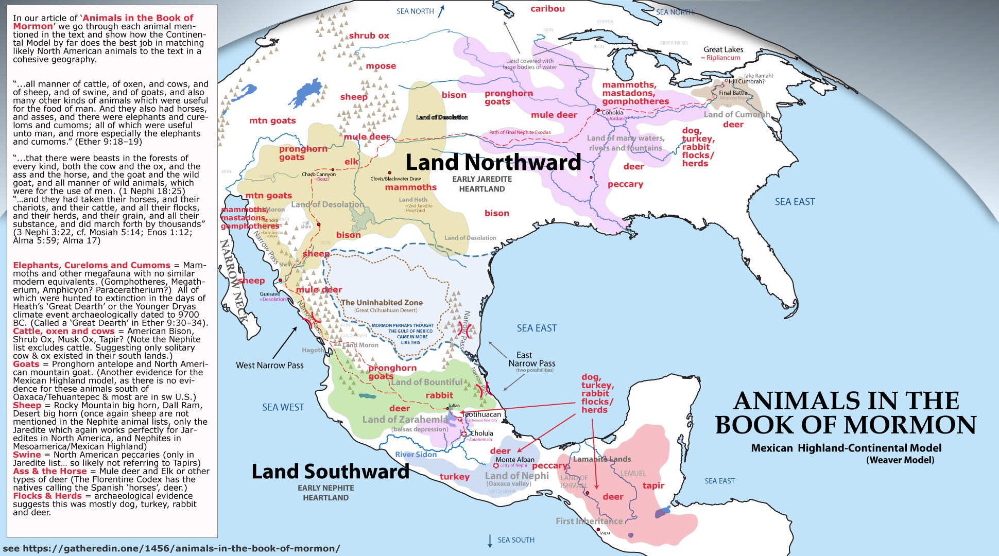
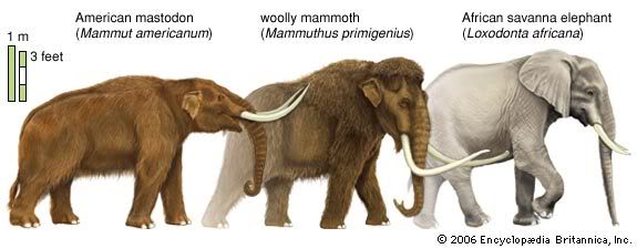
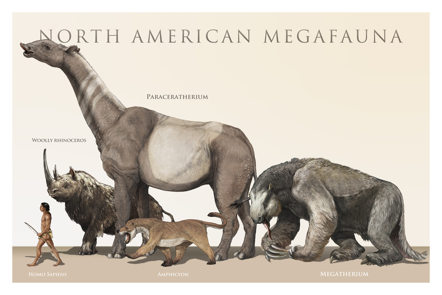
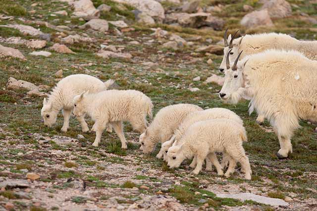
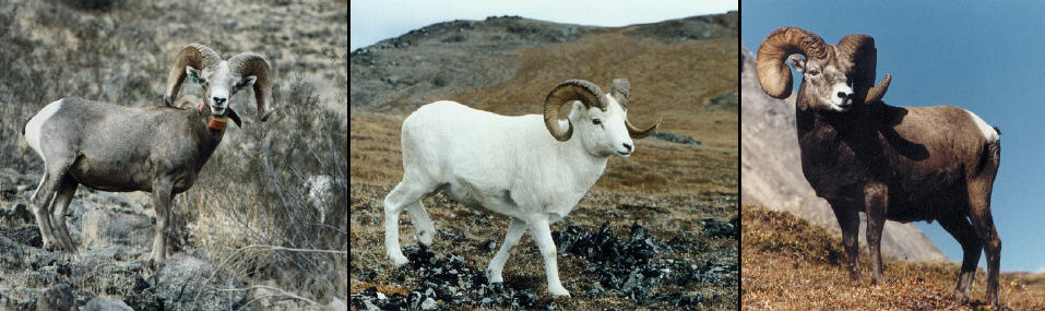
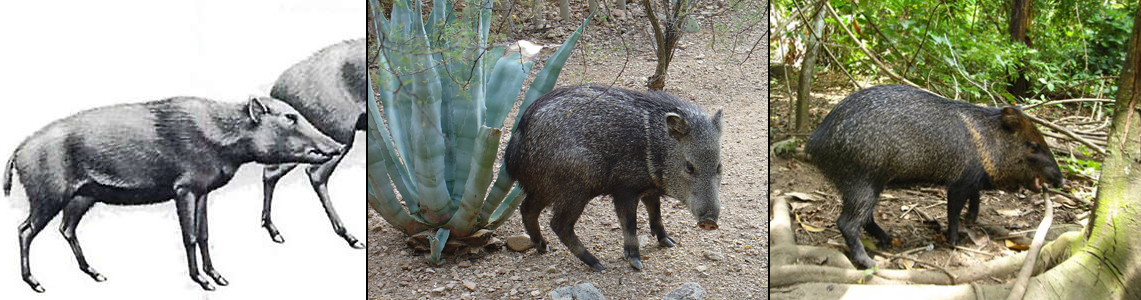
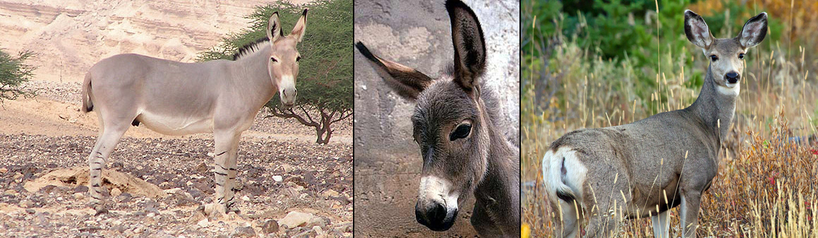
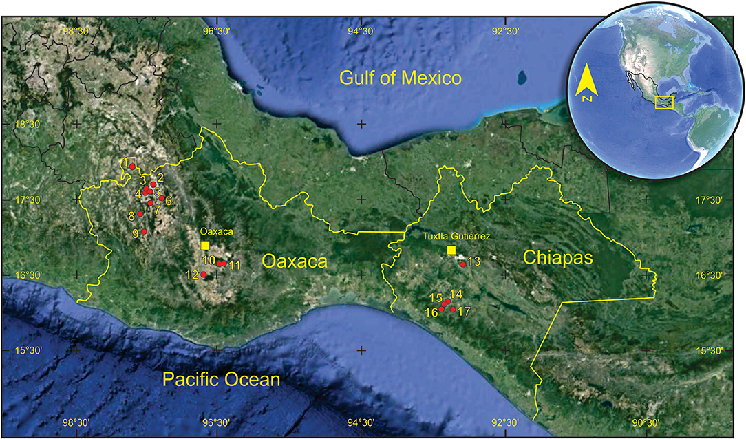
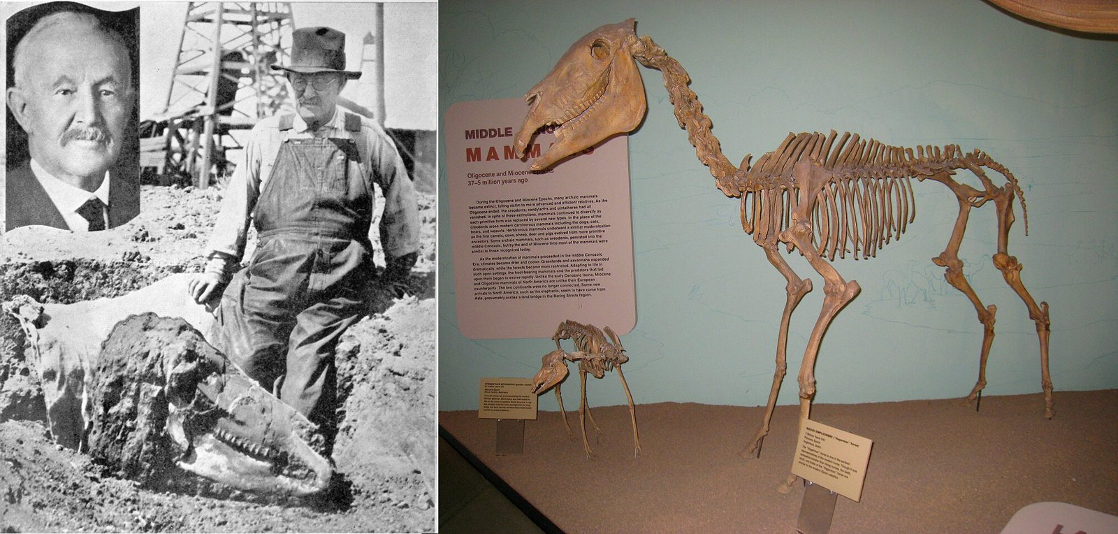
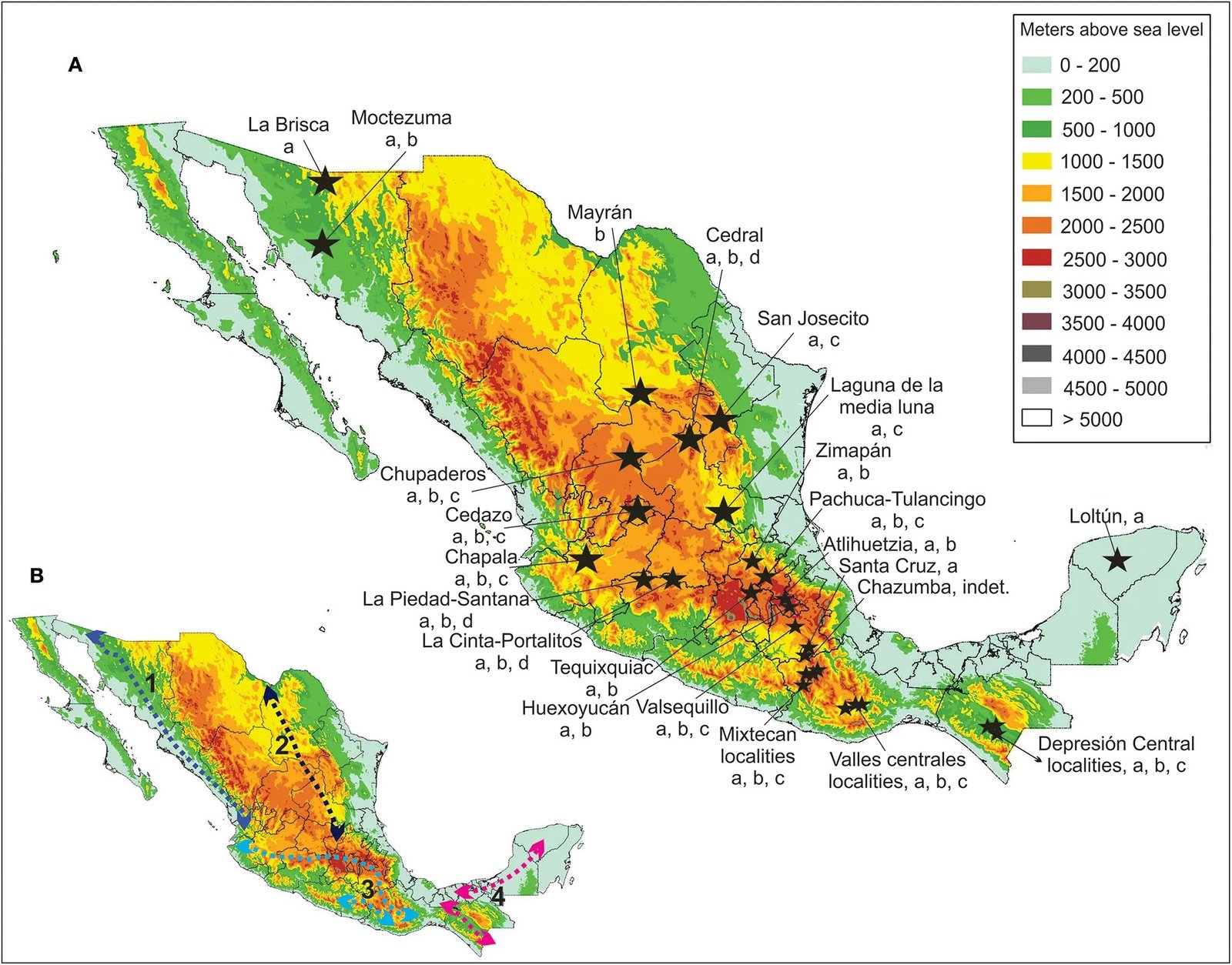
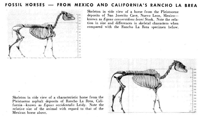
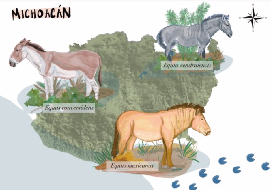
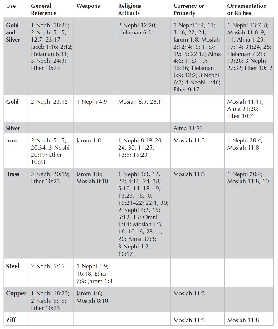
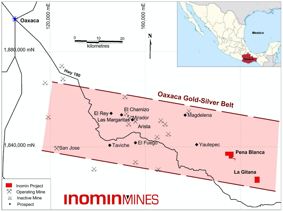
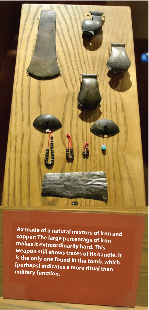
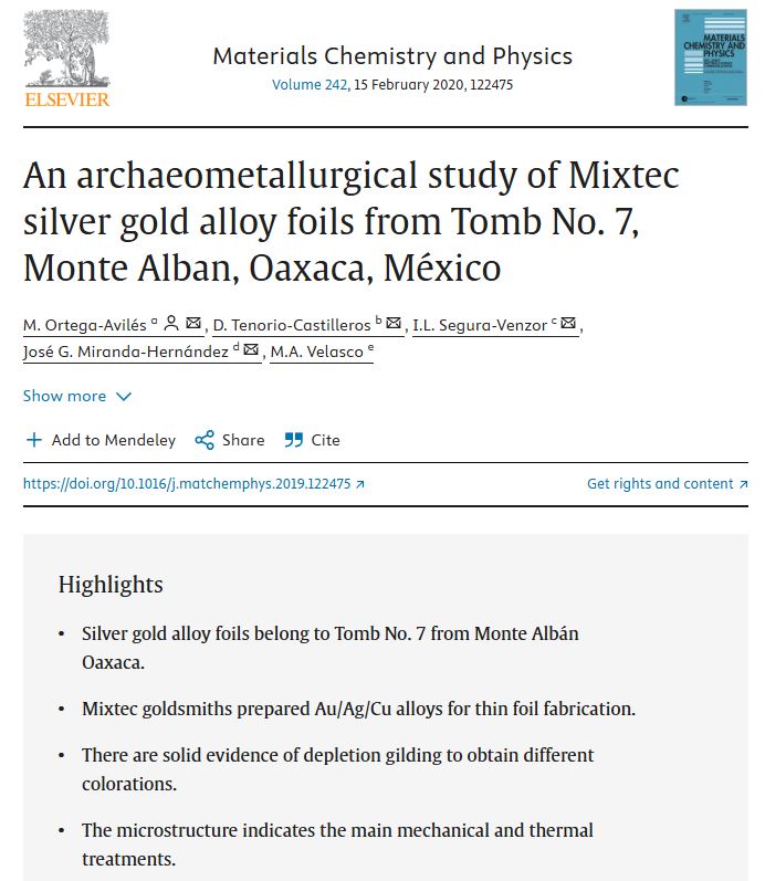
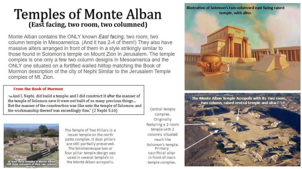
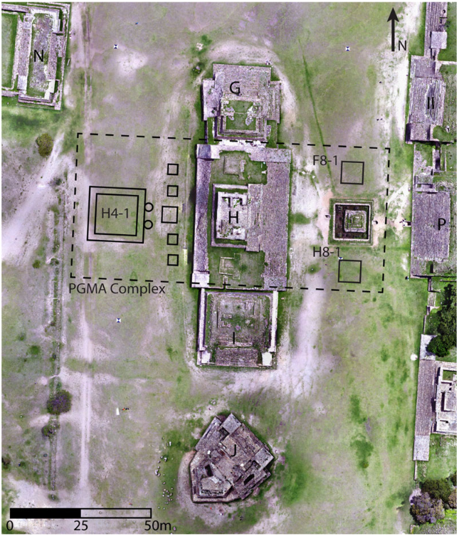
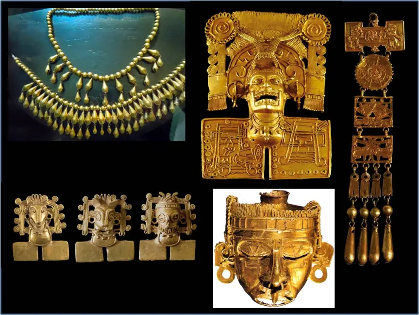
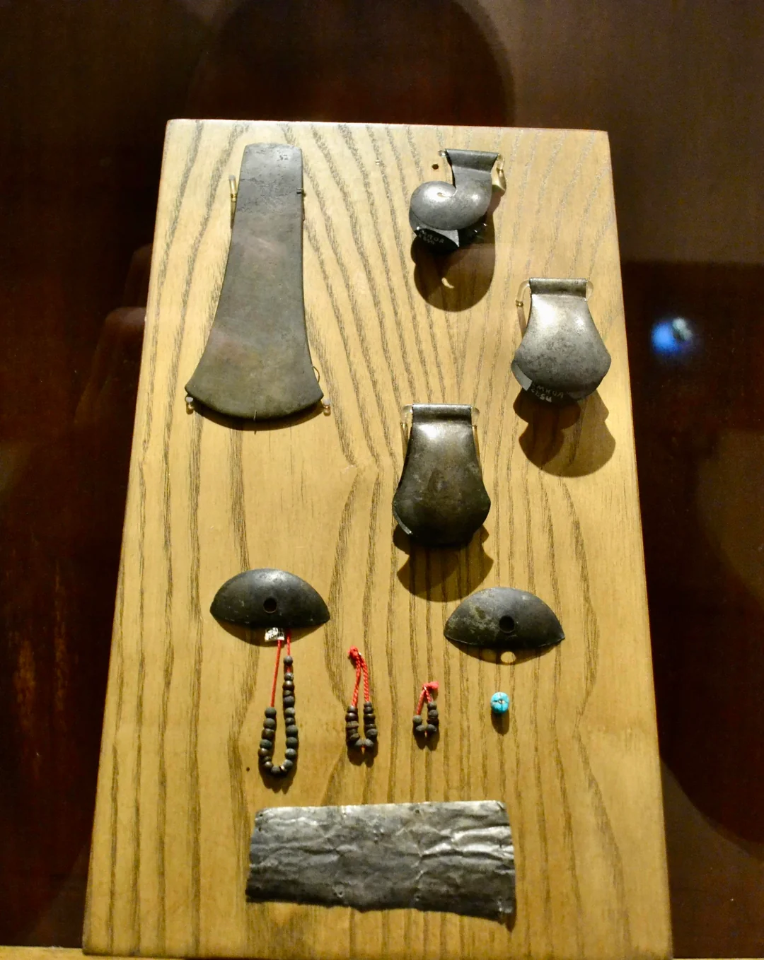
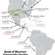
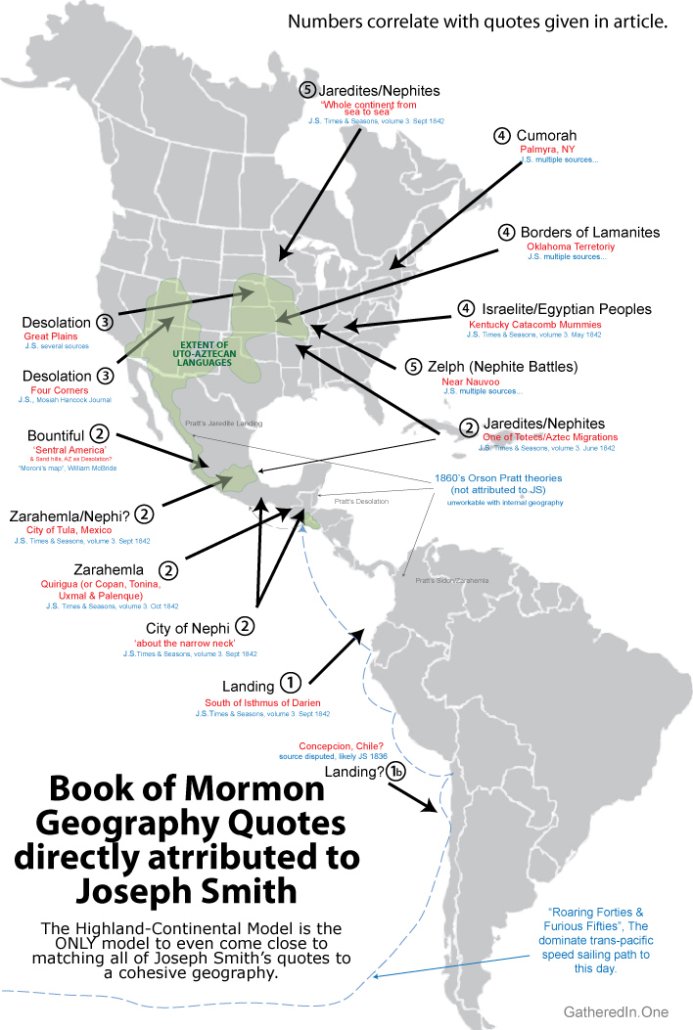
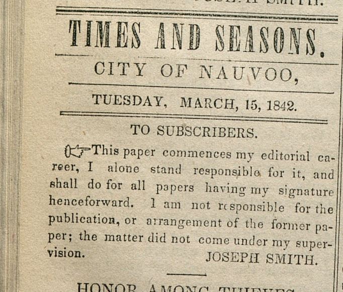
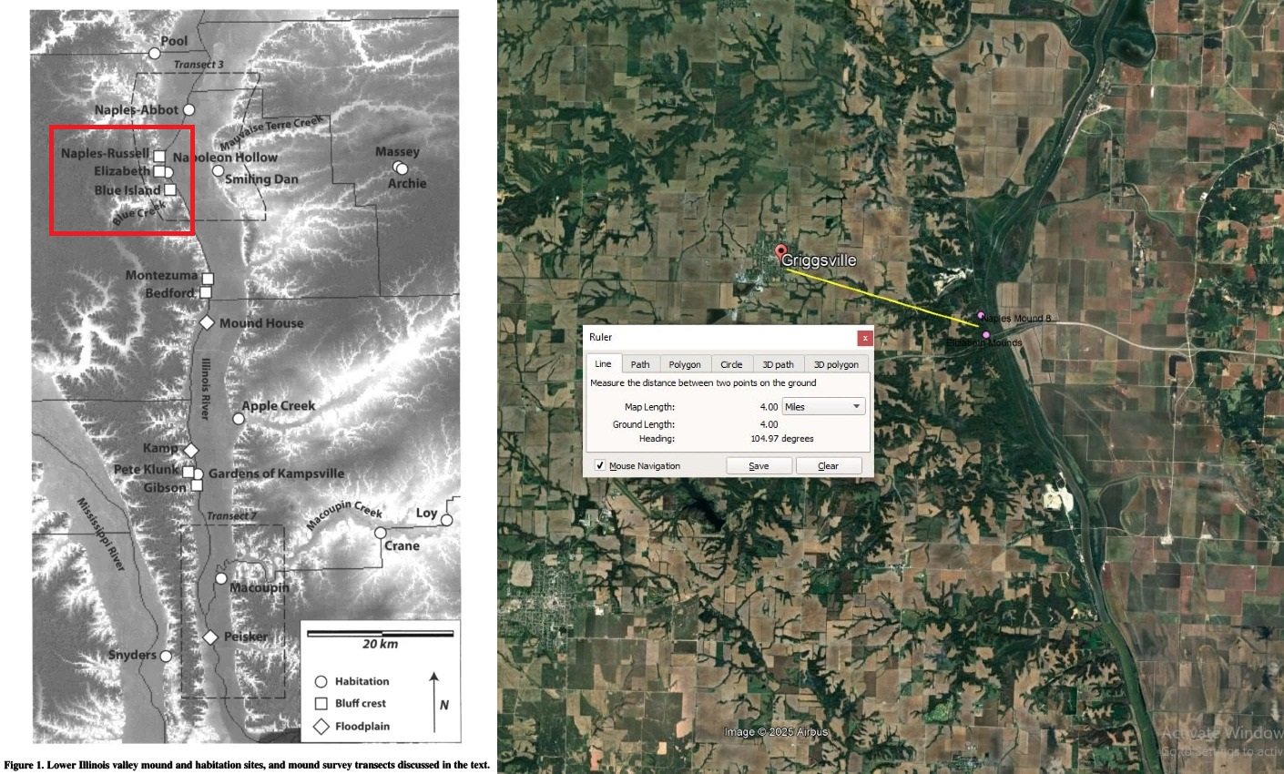
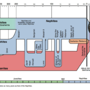
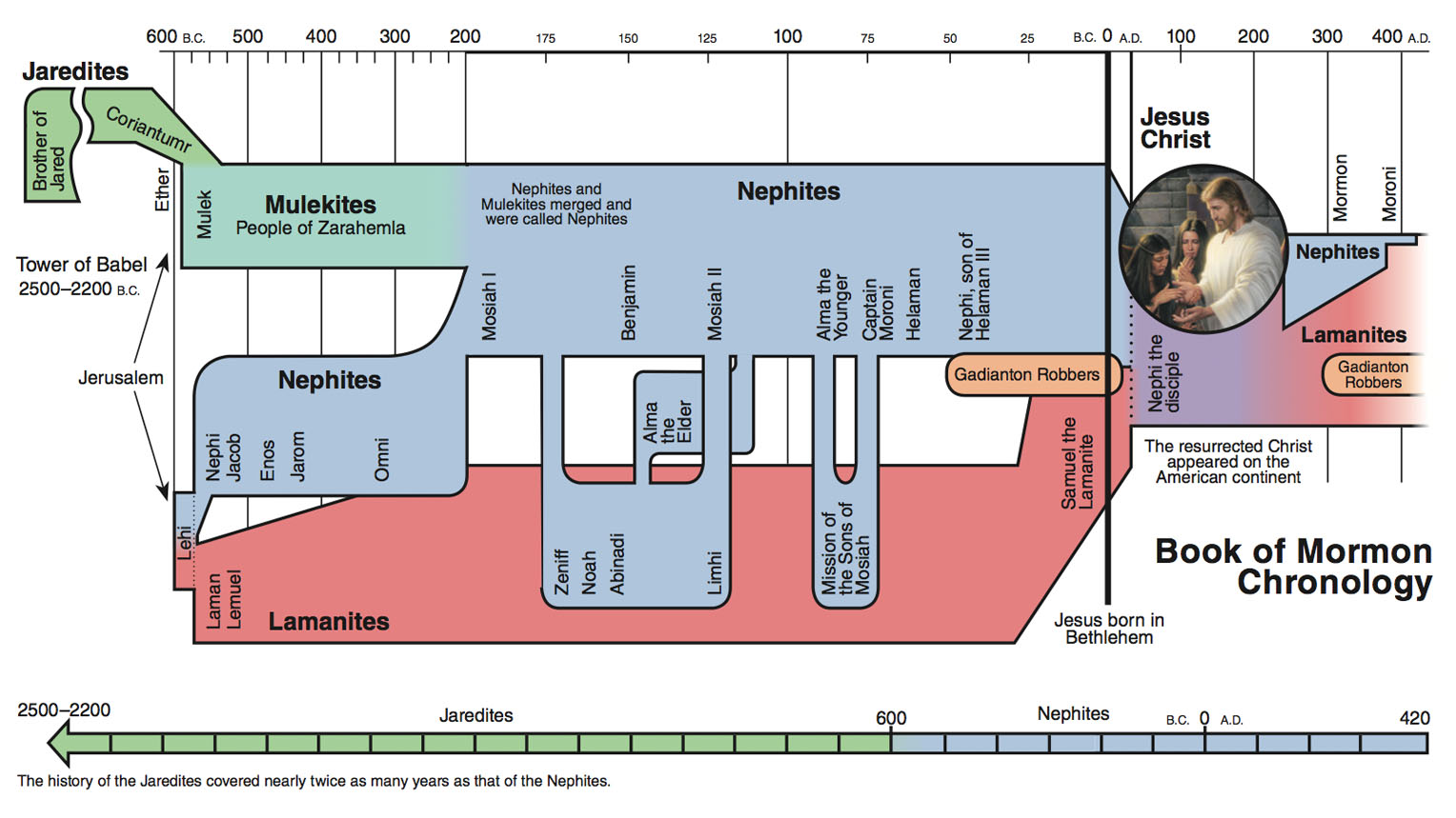
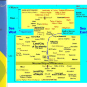
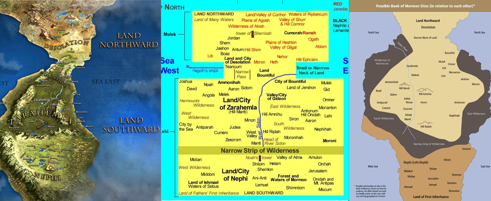
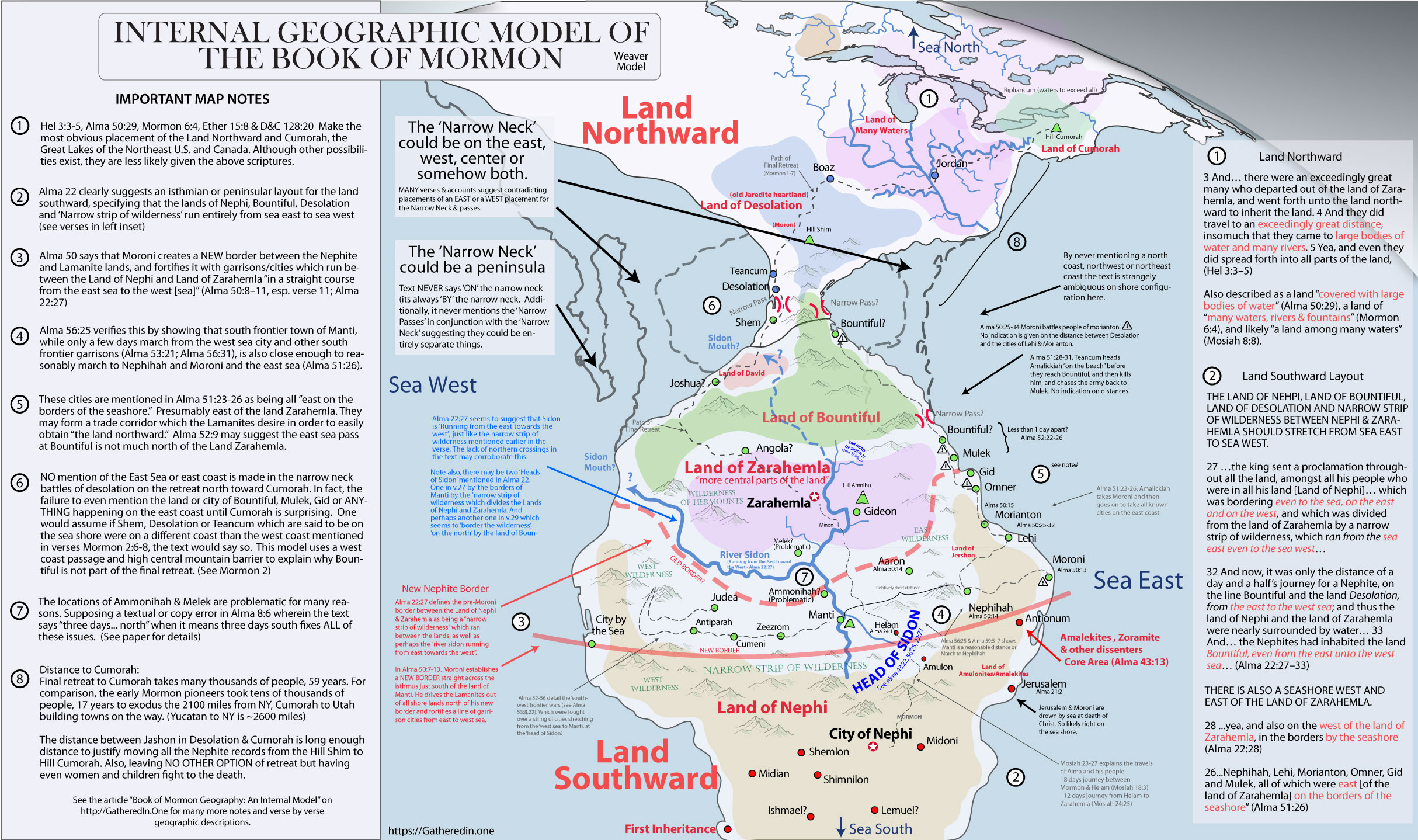
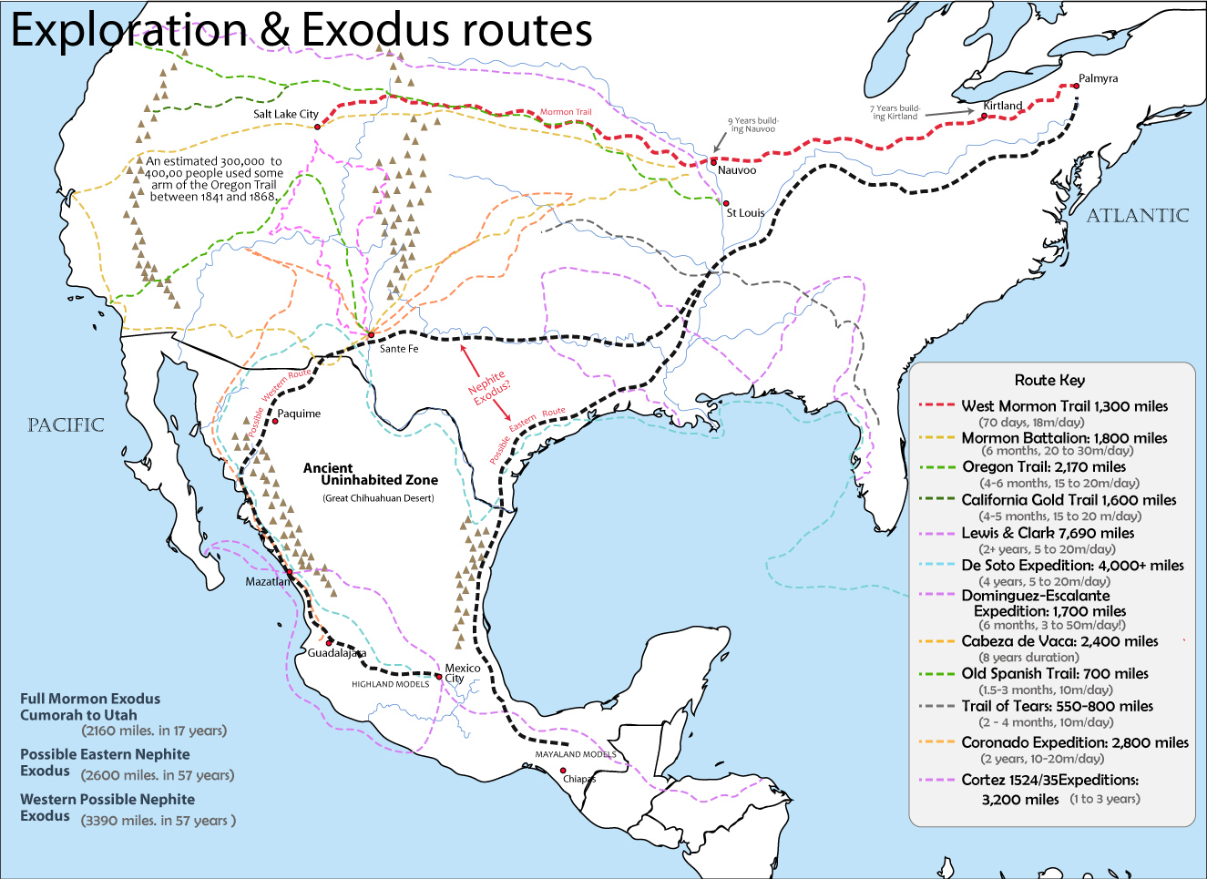
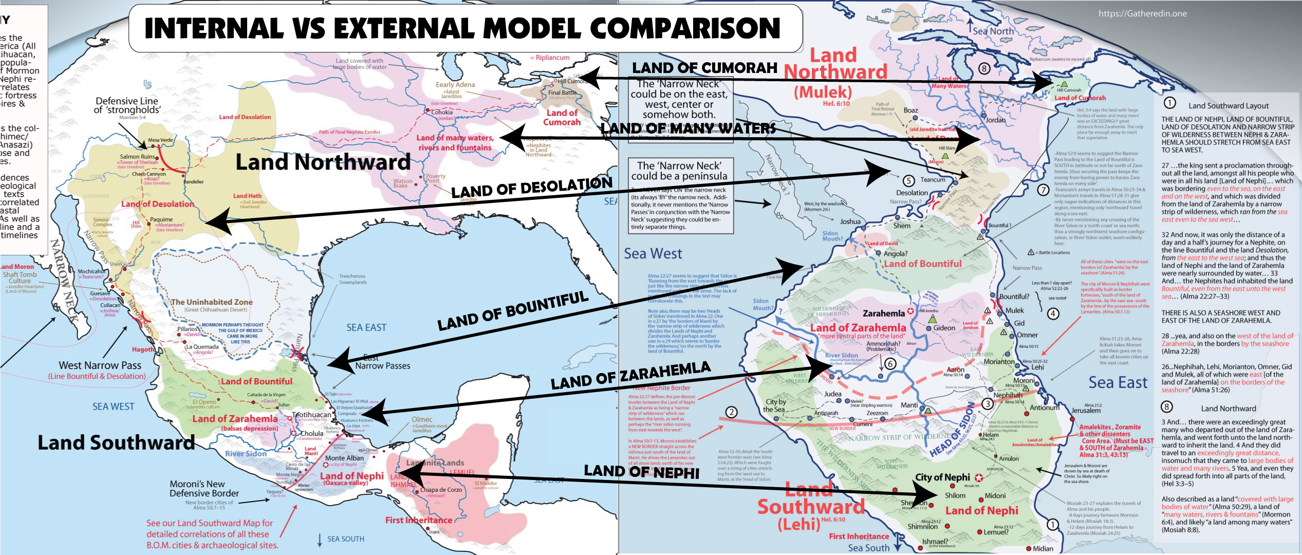
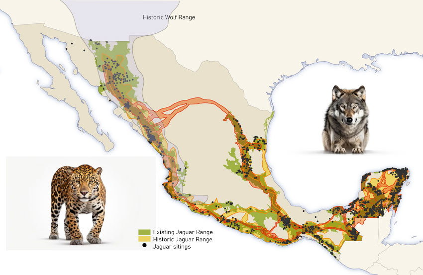
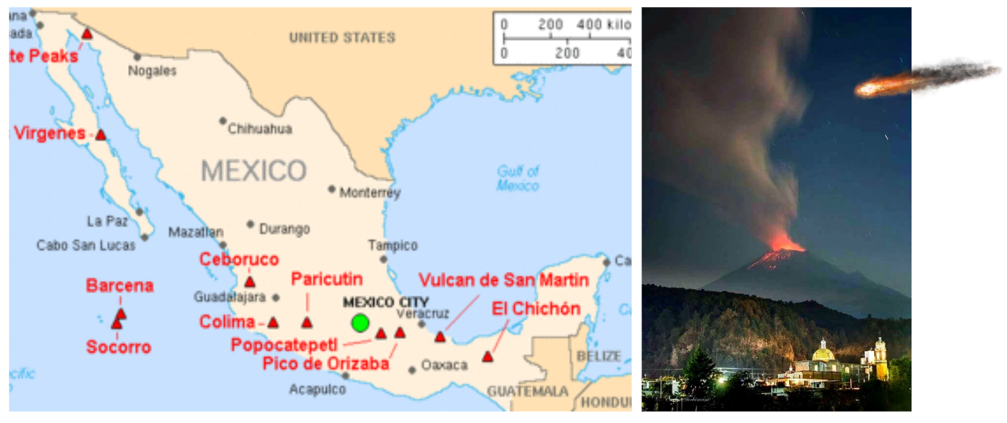
The views of this article are not entirely shared by the site author.
–
INTRODUCTION
It may be helpful to read Introduction to scriptural archeology for an introduction to this article covering important background information on why archeological dating methods give screwed results and on the geographical alteration of the narrow neck of land.
(To clarify dates, throughout the rest of the text scriptural/historical dates are preceded by S/H; while archaeological dates, including carbon dates, are preceded by A/C. In printed versions, footnotes which reference scriptures are in red; footnotes which reference archaeological sources are in black).
Correlated timeline of archeological and scriptural dates
THE SCATTERING AT BABEL AND THE EARLY JAREDITE CULTURE. Archaeologists place the first modern humans in the Near East’s fertile crescent around 100,00 years ago [72], which, according to our calibrated timeline, is immediately after the Flood. From there man was “scattered . . . abroad . . . upon the face of all the earth . . .” (Genesis 11:8) [73]; scientists following the path of homo sapiens identify a major scattering between 40,000 and 70,000 years ago when modern man spread from the Near East to Europe, the Far East, Australia, and the Americas [74]. In America, studies of hereditary traits on the first group of PaleoIndians to reach America have concluded that they consisted of no more than a handful of families (S/H: around 2100 BC; A/C: around 40,000 years ago) [75]/ [76]. The two earliest major PaleoIndian cultures that developed from this handful of families, the Clovis Culture and the Folsom Culture , spread widely but sparsely from the Southwestern United States to cover most of the continental United States [77]/ [78].
OMER AND HIS HOUSEHOLD. As this early period in American Prehistory was coming to a close, a small group of families left the core area and settled “by the seashore” directly east of the hill Cumorah (Ether 9:1–13) [79]. The group of sites, in and around northeastern Massachusetts, are called the Bull Brook Complex by archaeologists [80]. Clovis points found at several of the sites tie it to the Southwest [81]. Building on excavations by D.S. Byers in the mid-50’s [82], archaeological societies in the Northeast have pieced together the history of the Bull Brook Complex [83]. Their findings and subsequent analysis have shown the interactions of a system of organized, interdependent groups with specialized work force networks [84]. It is recognized as containing the highest level of social structure in America at that time [85], which would be expected in a “refugee camp” of the royal household [86].
PRE-DEARTH JAREDITE CULTURE. . As Moroni attests, the next archaeological period saw the rise of a richer and more diversified culture [87]/ [88]. The Plano and Early Eastern Archaic Cultures fanned across the continent (S/H: around 1600-1200 BC; A/C: around 8500-6000 BC) [89]. Scientists have found the full spectrum of plants and animals corresponding to the days of Emer. According to Moroni, during the early Pre-Dearth Jaredite time period they had “all manner of cattle, of oxen, and cows, and of sheep, and of swine, and of goats, and also many other kinds of animals which were useful for the food of man.” [90]Archaeologists have found many species of American bison from this time period, which ruminants are classified by zoologists as wild cattle, oxen and cows (family Bovidae, genus Bos) [91]. Similarly, there are food remains of Rocky Mountain bighorn sheep and Rocky Mountain goats at many sites from this period [92]. Peccaries are animals from this period which are classified as swine and are in the same group as domestic pigs and hogs (sub-order Suina) [93]. The “many other kinds of animals” of Moroni’s list would include deer, elk, moose, caribou, and pronghorn [94]. Thanks to new site-investigation methods, scientists have found that fruits, grains and vegetables were part of the PaleoIndian diet [95]; the Darwinian view that the PaleoIndians were merely carnivorous stockers of megafauna is being abandoned. More careful analysis of early sites and artifacts is yielding increasing evidence of fine textiles [96], which means the people didn’t just wear rough animal hides. Moroni also mentions that horses, elephants, cureloms and cumoms were useful to man, and that elephants and cureloms and cumoms were “more especially” useful to man (Ether 9:19). Potential beasts of burden which have been found in association with PaleoIndians include horses, tapirs, mammoths, mastodons, giant bison, giant ground sloths, and camels [97]. Coincidentally, the horse and the tapir would not have been very useful as beasts of burden because the Ice Age variety existent at this time were only about the size of a dog [98]; hence, it was the elephants and cureloms and cumoms which were “more especially” useful to man.
THE GREAT DEARTH. Then the PaleoIndian culture was rocked. In the scriptures, we read of secret combinations infesting society, and then a chastening, in the form of a great dearth (Ether 9:30–35). Archaeologists attest that it was probably the worst famine in North American history. Mass extinction spread across America as the Ice Age came to a rapid and catastrophic close [99]. Excess hunting by starving people and severe environmental changes drove the megafauna to extinction [100]. Scientists have found that serpents were abundant at that time in the American Southwest (as they are today) and the closing of the Ice Age caused many varied migrations in snake species across North America [101]. The serpents and the drought divided the people in the north from the fauna, which escaped to the south [102]. When the climate finally recovered, the people instigated a revolution in agriculture [103]/ [104], since they had now lost their domesticated animals.
POST-DEARTH JAREDITE CULTURE. Moroni’s next exposition on culture comes in the days of Lib (Ether 10:18–28). My corresponding period is labeled by archaeologists as the Middle and Late Archaic. Often indistinguishable from one another, these two cultural periods represent a major advancement over the preceding culture [105]. Again the culture spread across North America from coast to coast [106]. There were villages, agriculture, and widespread trade networks [107]. South of the narrow neck, in the Mexican highland and beyond, the only inhabitants we find are organized hunting parties, which “coincidentally” brought spear points of North American manufacture and style [108]/ [109]. Scientists recognize metallurgy from this time period, and copper is the most common metal found [110]/ [111]. Many fine textiles have also survived from this period [112]/ [113]. Moroni says they made “all manner of tools to till the earth, both to plow and to sow, to reap and to hoe, and also to thrash” [114]. He also says they had, “all manner of tools with which they did work their beasts” (Ether 10:26–27). Most of the tools on this list have been found by archaeologists at sites dating to the Middle and Late Archaic [115]. New weapons were also invented and manufactured, although archaeologists currently view them only as hunting weapons [116]/ [117]. Another major industry of the Jaredites was wood exploitation [118]. A huge assortment of woodworking tools has been found at Archaic period sites across the Nation [119]. Truly this was a highly-developed culture—a time of great prosperity. How tragic that they lost it all because of secret combinations! [120]
THE DESOLATION OF THE JAREDITES. The desolation of the Jaredites began in the Southwest and climaxed in New York State [121]. It is witnessed archaeologically by a widespread “cremation” burial culture [122]. Continent-wide scientists find a change in burial customs from proper burials to cremation burials and “ceremonial” burning of homes and entire villages (Shiz and his army) [123]/ [124]. Archaeologists have also found evidence of large-scale “bundle burials,” which is the practice of bundling the disarticulated, defleshed bones of dead people in bags or cordages, and then either burying them or dumping them in the trash [125]. Surely it was a gruesome scene that the first Nephites to re-inhabit the desolate land northward were required to witness and clean up [126].
Correlated timeline of archeological and scriptural dates
THE ARRIVAL OF THE NEPHITES AND MULEKITES. The Jaredites were the sole inhabitants of America until two small groups of sea-going travelers crossed the Pacific (S/H: 600 BC; A/C: 3000 BC). As early as 1916 scholars had identified the general location of the two landing sites. G. Elliot Smith published an article with Science titled “The Origin of the Pre-Columbian Civilization of America” in which he detailed ethnological evidence of the landings and further showed how scholars of that day had attempted to cover up the findings because they lent support to the Bible and against Darwinism [127]. In his book, Articles of Faith, James E. Talmage describes the author’s findings: “Dr. Smith presents an impressive array of evidence pointing to the Old World and specifically to Egypt, as the source of many of the customs by which the American aborigines are distinguished. The article is accompanied by a map showing . . . two landing places on the west coast, one in Mexico and another near the boundary common to Peru and Chile, from which place the immigrants spread.” [128]Archaeological evidence has further refined these findings. Most archaeologists now agree to a South American landing, putting it a little further north, specifically in modern Ecuador [129](which “coincidentally” lies “a little south of the Isthmus of Darien” [130]). The location of the second landing spot is unknown; characteristic artifacts also point to the west coast of Mexico [131]— legend puts it at a place called “seven caverns” [132]. Both the Valdivia culture of Ecuador (the Lehites), and the Otomangue-speaking people of the Mexican highland (the Mulekites), brought the first true pottery to the Americas; in both cultures the pottery was already well-developed even at the earliest sites [133]. Both cultures are distinguished as being the first harvesters of cultigens (plants incapable of growing without human help), the most important cultigen being corn [134]. The architecture and burial customs of these two groups can easily be tied to the Old World. Square waddle and daub homes with storage pits in the floor dotted their lands [135]. Their temples and public buildings are extremely similar to those of Egypt and Israel. Subfloor burials and burial positions also match those of the Middle East [136].
EARLY MULEKITE CULTURE. The newly arrived Otomangue-speaking culture (Mulekites) began to spread across the Mexican highland (Zarahemla). Although they covered a large area, they lived in small scattered villages, and archaeologists recognize very little social structure among them [137][138].
EARLY LEHITE CULTURE. The Valdivia culture also fanned out over a large area, stylistic pottery has been traced from Ecuador up through Columbia and Panama into Coastal areas of Guatemala and Southern Chiapas [139]. When Nephi fled from his brothers [140], it seems that he led his followers to the central depression of Chiapas and settled in the Grijalva river valley. The first cultural layers there are of a unique, tight-knit group (Zoque/early Nephite), centered around Chiapa de Corzo (the land of Nephi), which remained separate from the surrounding cultures that were developing (Maya/Lamanite) [141]/ [142]. The Nephite culture began the seeds of civilization which later influenced all of Mesoamerica, and eventually all of North America [143]. Some of the Lamanites appear to have followed Nephi’s party; a group associated with the early Maya (Lamanites) settled further up in the Grijalva river valley [144]. Other groups remained in South America which over time developed very independent cultures [145]; apparently not associated with the history outlined in the Book of Mormon.
EARLY LAMANITE CULTURE. The Lamanites (early Maya) digressed and became a very primitive people [146]/ [147]. Archaeologists label them as “hunters and gatherers,” because they stocked the forests for game, lived in tents and temporary shelters, and practiced limited agriculture [148]/ [149]. They did some fishing, and they had very limited agriculture (primarily limited to picking wild fruits and edible roots) [150]. Archaeologists think it was because they did not have the technology, the scriptures teach that it was because they were lazy.
Warfare is evident as archaeologists find a large assortment of weapons, far exceeding the needs of mere hunters [151]. The early Maya (Lamanites) set up chiefdoms in each local community; at this early date they do not appear to have been a cohesive unit, but rather groups of village communities, competing and perhaps fighting with each other for resources [152] — apparently united only in their hatred toward the Nephites [153]. Laman and Lemuel seem to have taught their children the pagan practices they had learned in Jerusalem. Archaeologists find cultic artifacts associated with the worship of a fertility goddess; they also worshipped Chac, who is the Maya equivalent of Baal from the Old World [154]. In this early period we also see the beginnings of the Jaguar cult. The Maya made costumes from the coats of beasts of prey and used these costumes in religious rituals [155]/ [156]. Early Mayan vices match those Enos and Jarom attributed to the Lamanites: pornography in the form of nude ceramic figurines, idleness, and drunkenness (typically chicha, an alcohol made from corn) [157]/ [158].
The Formative
INTRODUCTION TO THE FORMATIVE. At the dawn of the formative period there were several major demographic shifts which set the stage for the developing cultures. First, King Mosiah I and his people left the Land of Nephi (Chiapa de Corzo) and traveled to Zarahemla (central Mexico) to join the Mulekites (S/H: around 200 BC; A/C: around 1400 BC) [159]. This is seen archaeologically as an influx of Mixe-zoquean culture brings new advances to central Mexico, and public buildings begin to appear in the larger villages [160].
THE PEOPLE OF ZENIFF. Back in Chiapa de Corzo (the land of Nephi), the surrounding culture (Maya/Lamanites) destroyed all traces of the departing group (Nephites) [161]/ [162]. Shortly, however, high culture returned to the valley [163]as Zeniff and his people arrive and begin to build anew many public buildings and restore the land [164]/ [165]. The new inhabitants of Chiapa de Corzo (people of Zeniff) were an ethnically distinct group which did not mix with the surrounding Maya (Lamanites) [166]/ [167]. Initially their culture was very similar to that of central Mexico (from which they had come), but the similarities decreased as time went on and they (the people of Zeniff, now led by King Noah) became extravagant in their prosperity. Lavishness dominates the architecture and material culture of this period [168]/ [169]. Just before Chiapa de Corzo returned to Mayan Culture (Lamanites), the people of the Grijalva depression gave birth to one of the richest and most influential Mesoamerican cultures of the pre-Christian era—the Olmecs (Amulonites) [170]/ [171].
THE AMULONITES AND THEIR INFLUENCE OVER THE LAMANITES. The Amulonite (Olmec) culture seems to have developed in the lowlands of Veracruz, Mexico. The simple farming village of San Lorenzo (probably Helam) [172]/ [173]suddenly began a massive public works effort using slave labor (probably the followers of Alma) [174]/ [175]. Soon a handful of great cities commenced, and Olmec influence spread to other lands [176]/ [177]. Olmec art and religious themes support an Amulonite correlation: powerful, dominating priests, were-jaguar babies, female dancers, and a plethora of demi-gods and idols [178]/ [179]. Throughout the Mayan lands, Olmec teachers began to train the Maya (Lamanites) in the language and learning of the Mexican highland people (the Nephites) [180]/ [181]. With this new education the Maya began to prosper and make many technological advances [182]/ [183]. New trade networks spread across southern Mexico, the Yucatan and Guatemala, and all roads passed through Olmec lands, which made them vastly rich and extremely influential [184]. Some archaeologists call the Olmecs the “mother culture” of Mesoamerica [185].
THE FALL OF THE AMULONITES. As prophesied by Abinadi, the Amulonites (Olmecs) were soon devastated [186]/ [187]. Using a cesium magnetometer to detect buried basalt, Michael Coe, a professor of Anthropology at Yale University, and his group found mounds of monuments purposefully defaced, smashed and buried at San Lorenzo [188]. Other Olmec sites excavated in the area told the same story: seemingly the Maya (Lamanites) living among the Olmecs (Amulonites) in their gulf-coast empire revolted, defacing and smashing monuments, destroying buildings [189]/ [190], and as the Book of Mormon teaches us, massacring the ruling class (the descendants of the priests of Noah) [191]. The great Olmecs suddenly disappeared, but their influence over the Maya was seen forever afterward. The sparsely-populated Mayan lands were soon covered with huge temples and city-centers with art and architecture reminiscent of the Olmec style [192].
THE NEPHITES- ALMA THE ELDER AND KING MOSIAH II. Meanwhile, in central Mexico, Alma and his followers escaped to Zarahemla and established the church throughout the Mexican highland [193], witnessed archaeologically by new temples and synagogues built throughout the land [194]. Then, several decades later, Mosiah II founded a new democratic government [195], and each land began to build government buildings alongside the new temples (S/H: 91 BC; A/C: around 850 BC) [196]. Under the leadership of these inspired founders, the diverse societies of central Mexico integrated to become a very prosperous people [197]/ [198]. Unfortunately, in many communities this prosperity led to pride, social classes, and perversions, which are all quite visible in the material culture they left behind [199]/ [200].
Pre-Classic
THE NEPHITES- CAPTAIN MORONI. These two great nations, the Nephites on the Mexican Plateau and the Lamanites (Maya) in Southern Mexico, Guatemala and Yucatan, began to experience greater conflicts [201]/ [202]. Foreseeing the coming challenges, Captain Moroni prepared his people and their lands [203]. First, the weak lands were fortified and the southern frontier was strengthened [204]/ [205]. Hilltop fortifications began to dot southern Mexico in Veracruz, Oaxaca, and Guerrero [206]/ [207]. Great urban fortresses were created [208]/ [209]. For example, at Monte Alban (Manti), researchers from the University of Michigan found that some leader (Moroni) inspired the people of the valley of Oaxaca to move to the top of a nearby hill in the former “no man’s land” between two warring nations, and there build a fortress with up to 10,000 inhabitants [210]. The site has natural cliffs surrounding the city, its temples and its public buildings on three sides; on the fourth side, excavators found a two-mile long wall of earth and stone which still stands almost 30 feet tall and 50-60 feet thick [211]/ [212]. No wonder Mormon venerated the leadership, courage and vision of Captain Moroni and the manner in which he prepared his people for war.
After Amalickiah’s first attack, a second phase of construction was begun in which fortified cities and hilltop fortresses were built throughout the land of Zarahemla [213]which appears to have stretched from Oaxaca to Jalisco and from southwestern Michoacan to northern Veracruz [214]. Also, the Book of Mormon records Moroni pushing the Lamanites out of the east wilderness and on the west, then building new cities in these areas in order to create a more defensible border [215]. Excavations in southern and western Oaxaca and Guerrero, as well as central Veracruz are now showing such movements of peoples and the construction of new large defensive cities and fortresses [216].
During the time that fortifications were being built in the Mexican highland, a massive weapons production industry commenced throughout Mesoamerica, both in the Mexican Highland (Zarahemla) and in Maya (Lamanite) lands [217]/ [218]. To accommodate these war preparations, the peoples of the Mexican Highland (Nephites) made major breakthroughs in agriculture and built massive irrigation systems [219]. From that time forward, urbanization and trade specialization, with accompanying prosperity, enveloped the Nephite lands [220]/ [221].
The great war of Moroni’s time, and the wars that followed, are seen archaeologically in demographic and cultural movements of this time period [222], and in numerous monuments depicting warriors and captives in both Highland Mexico and Maya lands [223]. The Lamanites displaced and jumbled the Nephites numerous times [224]. There was also a great cultural mixing when groups of Lamanites converted to the Nephite religion and went to live among the Nephites [225], and also when groups became captives [226]. Cities experienced occasional upheavals, but most of them changed hands without noticeable ruin [227]/ [228].
THE NEPHITES- 57 BC TO AD 33. Time brought greater prosperity [229], which led to ornamentation and extravagant housewares [230]. Robbers also infested the land during this period [231]—archaeologist have found that many of the graves of nobles and of wealthy people were broken into and the riches were stolen [232]. The Book of Mormon teaches that as wars continued numerous groups sought refuge and peace by migrating to far-away lands [233]. Archaeologists date the Adena people’s arrival in the Ohio River Valley at this time [234]. The Adena cleared the land of the carnage and waste the land’s former inhabitants (the Jaredites) had left [235]/ [236], and they brought a new culture with the advancements and technologies of their Mexican homeland [237]. Others moved to the Southwestern United States, becoming the earliest Mogollon peoples [238]. Those who arrived in North America found a land covered with lakes and rivers—a much more lush environment than the one they had left [239]. The Southwest Cultures are famous for their dwellings of stone and cement; cultures of the East for tents; both cultures also built simple homes of scrawny wood poles and thatched walls and roof [240]. In a short time the continent was covered with hamlets and villages [241]/ [242]. The people soon turned to pagan and perverted practices, which spoiled their previously wholesome culture [243]/ [244]. There is evidence that the first Polynesians reached the Pacific Islands around this same time period [245]/ [246].
–
THE NEPHITES- ZION. . The destruction at the time of Christ was discussed earlier. As the ash settled [247]/ [248], a new culture spread across the land [249]/ [250]. In some ways, this new culture was more monolithic; in other ways it was more diverse. Throughout the Americas a new two-room temple replaced varying former styles [251]. A utopia of peace and prosperity is spoken of in legends [252]/ [253]. There is no evidence of weapons being used at this time [254], and the murals, figurines, and architecture show designs of nature, lines of symmetry and harmony, and displays of pleasant animals and domestic life [255]. Gone are all signs of a military elite, governmental force, and coercion [256]. The Hopewell, the Anasazi, the Mogollon, Teotihuacan, the Maya—continent-wide, the traits are the same [257]. The great peace resulting “because of the love of God which did dwell in the hearts of the people” (4 Nephi 1:15).
The people were united in righteousness [258], yet at the same time, the culture became more diverse, as the focus turned from making a profit to making quality products and upholding the ideals of family and community [259]. Local artisans replaced the mass-production and expansive trade networks of the preceding period [260]. Thus there was no need to travel extensively “on business,” so people could spend more time with their families. Family gardens replaced mass-produced food [261]. People ate a greater variety of food, but their food was of more local origin [262]. Analysis of skeletons shows that the people were healthier and enjoyed longer life spans than during the preceding period [263]. The arts flowered during this period [264]. The number and variety of musical instruments greatly increased [265]. Pottery and other goods became more useful and more beautiful, and less ornamental and extravagant [266]. A much greater variety of artifacts is found, but in much smaller quantities than before, and with much less waste [267]. The prosperity was great throughout all of the Americas and in all areas of human development, “because of their prosperity in Christ” (4 Nephi 1:23).
In the early classic period the church became very wealthy [268]. The people donated their time and skills to the creation and maintenance of beautiful temples and public centers [269]. The population exploded [270], but at the same time, the cities became less dense as the communities were reorganized and the people spread out across the land [271]. Even the biggest “cities” were only lightly populated, yet they contained ceremonial centers and public buildings large enough to accommodate all the people of the surrounding villages [272]. Social classes disappeared, yet the standard of living increased everywhere [273]; And “they were in one, the children of Christ, and heirs to the kingdom of God” (4 Nephi 1:17) [274].
It was beautiful. Everything Mormon said was true. Then they lost it all. The line is not clear, but little by little it all slipped away. The late pre-classic ugliness returned, and this time it was even more vile.
THE NEPHITES- PRIDE. As the people became proud, they began to flaunt the wealth they had accumulated over many years of righteousness and prosperity [275]. In the archaeological record, we begin to find much larger houses than existed in the preceding period [276], more decorated pottery [277], personal ornamentation (including pearls and elaborate clothing) [278]/ [279], extravagant burials of the dead [280], and new long-distance trade networks [281]/ [282]. They painted murals showing images of power, with soldiers, weapons, kings, priests, slaves, and eventually human sacrifice [283]. They built new cities with defense in mind [284], and the existing cities became more dense, decreasing in total area despite the fact that the population was still growing [285]/ [286]. We see evidence of the rise of social classes, with a new elite class and a definite peasant class [287]/ [288]. The social classes are most apparent in the big cities.
Political players began to build up monuments to themselves, often showing off their accomplishments [289]. We see a cultural split, as the people broke up into different groups [290]/ [291]. As displays of wealth and power emerged in society and later in government, the church was divided, as the people in every land sought to raise up their own version of Quetzalcoatl (Christ), and to join him with a new pantheon of gods and demigods [292]/ [293]. In the major ceremonial centers, a priestly class began to exercise power and influence [294]/ [295]. Temples and temple complexes became colossal and extravagant [296], and often the priests raised themselves to the position of gods or claimed descent from the gods [297]. Priests and government leaders began to deform the skulls of their children, and to give themselves and their children tattoos and body paint, all in an effort to separate themselves and their children from the “commoners” [298]. Gated communities were developed to protect the elite from the lower class [299].
On the eve of society’s collapse, the pride turned absolutely disgusting [300]. Most of the pottery and art became warped, lewd and pornographic [301]. Mass production fed trade networks which branched across the continent and resources were exploited on a massive scale [302]/ [303]. Food production became intense, and the general health of the people correspondingly deteriorated; the incidence of disease increased significantly and life expectancies dropped drastically [304]. Body piercing became the norm [305], tobacco and drugs were used widely; smoking was done in smoke houses and in private homes, with cigarettes and with pipes [306]. Huge ball courts covered the land [307], in some places ball players rose to the state of gods [308]. The ball games became very bloody [309], and in many places they were accompanied with mass killing and human sacrificing of the winners or losers depending on the local religion [310]; in other areas the losers become the slaves of the winners’ rulers [311]. Many people wasted their income on various forms of gambling—they rooted on their favorite teams, or played games of chance with dice and bones [312]. In many areas the workmanship of the structures built during this period was poor, but it was covered with decorative plaster, and was elaborately finished [313]. Cultic symbols and status symbols are found everywhere [314].
THE NEPHITES- DESTRUCTION. Truly this society was ripe for destruction [315]. The Book of Mormon tells us that the destruction took place quickly [316]. Archaeology tells us that it occurred on a massive scale [317], larger than most probably ever imagined— although Mormon tried to help us understand [318].
The great war appears to have been started in central Yucatan by a group which archaeologists call the Putun Maya [319]. As they gained power they continued west and north, and eventually attacked the Mexican highland [320]. Great murals tell the story of their advances; they were the eagle warriors of the jaguar cult (the Lamanites), and they sought to exterminate the cult of the feathered serpent named Quetzalcoatl (the Nephites) [321]. Eventually the great city of Zarahemla (Teotihuacan) was attacked, but the invaders were pushed back [322]/ [323]. Then, as Mormon relates, Zarahemla (Teotihuacan) was laid waste [324]. Archaeologists have uncovered the entire story: the great Teotihuacan was burned and looted, monuments were defaced, columns were toppled, temples were desecrated, and the luxurious palaces were left in ruin [325].
The Lamanites’ pursuit of the Nephites can be followed from Teotihuacan to Western Mexico, to sites such as Alta Vista and Chalchihuites (perhaps Angola or the Land of David?) [326]/ [327]and then to the seashore, to Amapa and other sites in Nayarit and southern Sinaloa (probably the land of Joshua) [328]/ [329], a land archaeologists have found was filled with robbers and Maya during this period [330]/ [331]. From there the Nephites continued their flight into the “land northward” [332]. It appears that the massacre stopped when the Nephites reached Chaco Canyon (Shem), in New Mexico and were able to fortify it [333]/ [334]. There the Nephites held back their pursuers and the bloodshed stopped for a season while God sent forth missionaries and prophets to give the people one last chance [335]. Archaeologists have found circular religious structures, called kivas, appearing throughout Anasazi lands during this period [336], which perhaps shows that Mormon knew some success [337], though his own testimony indicates that any success was short lived as the wickedness persisted [338].
For ten years a peace treaty was in effect [339]; archaeology shows that the Maya (Lamanites) of Yucatan and Maya Chichimec of West Mexico came together and began building the great Toltec kingdom [340]. Toltec legend speaks of the war between Quetzalcoatl, the feathered serpent, and Tezcatlipoca, the principal god of the Jaguar Cult [341]. The Toltecs boast Quetzalcoatl’s defeat and subsequent flight [342]. As the population of Tula was exploding [343], archaeologists find an abandonment of Yucatan by that area’s elite [344]. Recruits by the thousands flooded out of Yucatan to their new blood-thirsty, warrior kingdom centered in the Mexican Highland [345]. Many were also moved to the battle line in Western Mexico, as archaeologists find a large influx of Toltec peoples with strong Maya ties building up fortresses and making war preparations [346].
The kingdom of the Nephites centered in the Southwestern United States, and although they focused on defending the land for a short time [347]/ [348], they soon turned their focus to the “god” of money [349]. Trade networks covered the Southwestern United States [350], and turquoise, which was lusted after by the Toltecs, was mined on a huge scale to be traded for exotic Mesoamerican goods [351]. Ball courts, gated communities, lewd pottery and art, body painting, body piercing, gigantic cities, social classes—the signs of pride and wickedness—have been found by archaeologists throughout the Southwest United States and Northwest Mexico (the Nephite lands) [352].
Then, at the end of this fragile moment of peace, destruction continued [353]. The blood-thirsty Lamanites (Toltecs) based in a city just south of our narrow neck of land (probably La Quemada) came up against the Nephite armies which were based in Desolation (Zape in northern Durango?) [354]/ [355]. The Lamanites were repulsed and counterattacked, but they soon swept Desolation and later Teancum (most likely Guasave on the Pacific Coast) [356]. From there the fleeing Nephites followed the turquoise trail to Boaz [357], now known as Paquime or Casas Grandes in Chihuahua. Charles C. Di Peso, the first archaeologists to conduct large-scale excavations at the site, found signs of a great slaughter at Paquime [358]. Unburied dead bodies were strewn across the site, some had been shoved into the ducts of the water system, others sacrificed to pagan gods, but the majority were just left to rot and be preyed upon by wolves and vultures [359]. Mormon painfully records these same events, as he stood back, watching: “And (the Nephites) fled again from before (the Lamanites), and they came to the city Boaz; and there . . . the Nephites were driven and slaughtered with an exceedingly great slaughter; [and]their women and their children were again sacrificed unto idols” (Mormon 4:20–21).
The slaughter spread across the entire Southwestern United States [360]. Thousands of sites from this period have been found in which the site was either abandoned or burned or the people were slaughtered [361]/ [362]. In many places the people abandoned their scattered farms and gathered together to build great fortified cities to defend themselves, only to be massacred [363]/ [364]. But this was not a peaceful, righteous people being victimized. There is evidence of cannibalism among the Anasazi and other Southwestern Cultures (the Nephites) [365]/ [366].
Archaeologists have found human bones in cooking vessels, necklaces made of human skin or bones, and mobiles made of human bones and skulls which seem to have been used as trophies—signs of status and prestige [367]. They have found apparent ceremonial assemblages of skulls which were presented to false gods [368]. At Salmon Ruin, New Mexico (possibly the tower of Sherrizah) [369] women and children were abandoned by their covenant protectors, and the children were burned alive, caught in the top of the tower [370]. There are countless archaeological and scriptural evidences of the deplorable state of the Anasazi/Nephites; their brutal mutilation and total annihilation are painful to read about.
The destruction in the Southwest climaxed at a line of sites from Mesa Verde, Colorado (probably Jordan [371]) to Albuquerque, New Mexico [372]. The entire Southwestern United States and Northwest Mexico was left desolate, except for a few small scattered groups of refugees who hid in caves [373]/ [374]. But the destruction continued.
The line of sites mentioned above was actually a line of defense built to protect the great expanse of the American Midwest [375]. The Nephites who covered the Midwest are called Mississippians by archaeologists. Highly influenced by Mesoamerica and the Southwest [376], their culture had also passed through the cycle of simple and peaceful [377]to ugly and proud [378]. Their artwork from this period glorifies death and perversion [379]. There are carvings of goules, war dances, and the murdering of captives, and these are found alongside symbols of Christ (hands with marks appearing to symbolize the crucifixion) and symbols of Quetzalcoatl, the feathered serpent, displaying decapitated heads as a symbol of his power [380]. These were not ignorant people suffering for the sins of their parents; they were in open rebellion against God [381]. They refused to repent and trust in God, but rather put their trust in the arm of flesh thinking that could protect their lives. It would not be and never has been [382].
Soon after the cultures of the American Southwest were slaughtered, the Mississippian culture disappeared [383]. Huge ceremonial centers, like Cahokia in southern Illinois, built in the styles of the Mexican Highland, were suddenly depopulated without evidence of struggle or warfare—sites are not burned as in the Southwest, nor are the dead strewn across the landscape [384]. Because of the late carbon dates obtained from these sites some archaeologist have attempted to show that the people just redistributed themselves around the local area [385]. However, the Book of Mormon as well as the immense collections of arrowheads dating all the way back to the archaic found canvassing parts of New York State and the entire New England area speaks of a great desolation (The Book of Mormon states the final battles occurred in the “land of Comorah”, which likely encompasses a large portion of New England; not just around the current Hill Comorah as many have supposed) [386]/ [387].
Truly God is unveiling his truth in the eyes of all the world. It remains for us to read with faith, work with strength, and repent of our pride. We must go forward in a definite way and bring to pass the covenants of the Father and build up the kingdom of God upon the earth; both in small and simple ways and by making preparations for works of greatness.
OLD WORLD (BIBLICAL) ARCHEOLOGY
After I had found many evidences of events in the Book of Mormon, and had developed a revised timeline for archaeology, I became curious as to whether my timeline would also work if I used it on Old World archaeology. I found many interesting “coincidences”. Following is a very brief account of a few of my findings. An entire paper on the subject will be forthcoming.
Evidence of pre-flood cultures appear to be entirely missing from the archaeological record. It is as if Earth’s baptism literally washed her clean. She contained no trace of the former sins of her inhabitants. Most of the early homo sapiens cultures that I would label Post-Flood are in the fertile crescent, and usually at a depth of between 30 and 50 feet below the surface [388].
Early Egypt was below water as Abraham attests [389]/ [390], and the earth was sparsely populated [391]. The climate during this period soon after the Flood was much milder and cooler than it is today, and the plants and animals from this period match those described in the Bible [392]. The desert climate would not come for many generations (after many droughts and curses). When we consider the depth at which these early cities are found, we realize that the only reason these sites have been found is that either the sites were continually inhabited until modern times, or the archaeologists were extremely lucky. Many early cities exist which have not yet been found as attested as by new sites which are continually popping up.
History really starts to take place after the Exodus. Let us consider Jericho. Using the “corrected” timeline we established by studying the Book of Mormon, and extrapolating our dates backward, we find that the Jericho of the Bible must be dated at around 7000-8000 BC. During this time period there was a Neolithic city at Jericho, surrounded with a great wall, and with a massive tower built right into the wall (possibly the house of Rahab/Pre-Pottery Neolithic A) [393]/ [394]. There is evidence that the people of the city were pagans, and that they were rich and proud [395]. The early city’s culture ends with the walls falling down and a new culture replacing Pre-Pottery Neolithic A, they are labeled Pre-Pottery Neolithic B (Sci- 6500 B.C.; Scr- 1450 B.C.) [396]/ [397]. Interestingly, the tower that was built into the wall survived to its full height into the next period (Rahab and her family were protected) [398].
This new nation had simple beginnings; archaeologists call it a retrogression because of the decrease in riches and more simplified art. However, there were many advances: they had a united nation seen in the form of a new wide-spread monolithic culture, they began inhabiting many new lands and developing the land, they respected their dead ancestors, they had domesticated animals, and they built nice square plaster-floored homes [399], which, “coincidentally,” were similar to the homes of the early Lehites and Mulekites [400]. After many years the nation became very wealthy (Pottery Neolithic A&B) [401], and then, as we can tell by studying cultural artifacts, the nation was divided [402]. One group inhabited the north, and the other group lived in the south (Chalcolithic Period) [403]/ [404].
The nation of Israel prospered during the entire period from the time it entered the Land of Canaan until the end of the Chalcolithic Period. Then suddenly the Kingdom of Israel in the north (the Ghassulian culture) was displaced, and new people from Syria and Southern Mesopotamia, labeled Proto-Urban A, were ushered into the region (Early Bronze Age) [405]/ [406].
The Kingdom of Judah in the south continued to prosper [407]. However, she did not learn from watching Israel fall (she did not repent), and little over a century later, she was also destroyed [408]. At the end of the Early Bronze Age every major city in the south was destroyed and depopulated—some incredibly violently [409]. The Bible clearly teaches that this was done by the hand of God—his tool being a new empire he had risen up in southern Mesopotamia—the Kingdom of Babylon [410]. Archaeologists also find this new kingdom in Mesopotamia but they have called it the kingdom of Akkad [411]. Judah was left desolate. Only small scattered villages and groups of wandering nomads remained (Intermediate Bronze Age) [412]/ [413].
When the Kingdom of Akkad (Babylon) fell [414], Judah was repopulated by a vigorous new group of people which began to rebuild the land (Middle Bronze Age) [415]/ [416]. The people prospered and the entire region flowered [417]. The succeeding period also saw a continued prosperity, but under Indo-Aryan influence (Alexander the Great) [418], followed by strong Egyptian (Ptolemaic) control (Late Bronze Age) [419].
As the period continued, Egyptian power weakened [420]and a group of “adventurers” are noted as coming down from Syria and establishing an Amorite kingdom (Seleucids) [421]. Archaeologists then find evidence of an internal revolt that occurs, led by the ‘Apiru (Hasidim under Maccabeans), in which a war commences by a guerrilla-type group of warriors that rally the principally Hebrew (Jewish) community to rise up against the Amorites (Seleucids) [422]. Many wars follow with great destructions but the nation that remains in the end is obviously Israel. The carbon dates for these events (about 1300-1200 B.C.) lead scholars to believe this may be the time of the exodus and subsequent conquest of Palestine. Little or no archaeological evidence of Joshua or the exodus exists at this time, however, and the carbon dates assigned to the various cities’ destructions do not match the Bible which declares the conquest to have occurred around 1400 B.C. [423]These discrepancies have led many biblical scholars to abandon the literal interpretation of the Bible and create many diluted theories that minimalize the book [424]. Interpreting the archaeology as evidence of the Maccabean revolt on the other hand, as we are proposing, matches almost exactly [425].
Next, archaeology shows the arrival of a new group of people called the “Sea People”. They ruled every land that touched the Mediterranean Sea [426], and though their origin continues to evade scholars they know it was somewhere in the area of Sicily, Italy, or Greece (Rome) [427]. The people conquer lands matching Rome’s accomplishment in Greece, Turkey, Egypt and Palestine [428].
Conclusions & Significance
Archaeologists and biblical scholars have long been at odds. As archaeology began to mount a horrendous amount of research, all placed by carbon dating, many biblical scholars began doubting the Bible. Scientific dates were given supremacy and new biblical scholars decided that the Bible was not completely accurate. They began trying to fit whatever they could into the archaeologists’ framework and discarded the rest as fable. The result was a great archaeological mess and a complete abandonment of the scriptures as the “Word of God” and absolute truth. Following the history of science and seeing societies turning away from God is very sad to read.
Now, our research seems to have discovered that the archaeologists are actually proving the Bible to be true and they don’t even know it because of the dating problem. So now, with the correlated time line created studying the Book of Mormon, we see the Book of Mormon proving the Bible to be true, which we are taught is one of its purposes (Mormon 7:8–9; 1 Nephi 13:38–41).
A future paper on Bible lands will show most all the fabulous stories of the Bible laid out in the dirt, just as the prophets said they happened, and just where the prophets said they happened. We will see that these wonderful stories which are disbelieved by most archaeologists, have actually been found by archaeologists!
These findings are of great importance. Our society has abandoned the scriptures. We have replaced the eighth article of faith with a new one that says: “We believe the scriptures to be the Word of God as far as they correspond with science; we believe science to be supreme truth on all subjects it chooses to address.” This cannot be. Geology, biology and archaeology cannot be allowed to replace the sure testimony we have of the creation. Psychology cannot be allowed to replace the reality of Christ as our healer. Any doctrine or teaching which denies Christ is not of God. Omitting God is denying God because God has clearly stated that he is the creator and he is the truth, the way, and the light so leaving him out is going against his word.
We need to see the scriptures for what they are—they are not exaggerated stories, and they are notjust stories told by old men who meant well but who were off on the details because they were limited to the scope of the learning of their own cultures. The scriptures are the word of God, told in truth by men who literally talked with him! They were written to warn the nations of the world to believe God and to fear God and to worship only him. The scriptural events happened just as we were taught when we were children. Moses was not just a Hebrew slave born in Egypt who had a limited understanding of time and a limited understanding of the size of the Earth, and of how the history of his people fit into the grand history of the earth. He had a deep understanding of these things because he learned them directly from God! When we realized that everything in the scriptures is literal, then suddenly we realize that we, as part of this great latter-day nation, must repent, or the destruction that has been prophesied will occur. We know that the proud and the learned who will not hearken to their Creator will be cast off forever. We must beware of those who perpetuate the Theology of Science and say there is no God because they have not seen him. These people deliberately discourage others from believing in God, and they do it using every imaginable discipline—history, archaeology, biology, chemistry, physics, astronomy, and many other subjects. We must not allow people who live in sin, and therefore have not eyes to see, to lead us, for they will then be “blind leaders of the blind.” We must beware of the fanciful doctrines of Satan—precepts of men so wonderfully mingled with scripture that they appear to be true. We must beware of those who look beyond the mark. They despise plainness, and they “kill” the prophets with their words and their doctrines. God has taken his plainness away from them and has given them many things which they cannot understand, because they desired it.
A new generation is being raised up, and to them God will prove all his words, because they believe. God will show them how he changed the times and seasons in order to blind the minds of the proud and the learned, that they would not understand his marvelous workings. (D&C 121: 12) This generation will prove the scriptures to be true, every whit. Fools have mocked the words of Moses and Mormon and Moroni, but they shall mourn. God’s great work will go forth!
I would plead with everyone to make the scriptures a more integral part of your education. I would encourage anyone with problems to seek from the Word of God first and only believe other teachings as they compliment the teachings of the prophets. I would encourage students to first read God’s take on every issue before diving into your studies so that you can have the spirit of prophecy and discern between truth and the speculations of man. Science is wonderful, it is the process of seeking truth in the world around us, but it is not absolute truth, it is not infallible, and it is not the word of God. Search the scriptures specifically on the subjects you are studying and you will be overwhelmingly amazed at the wealth of information.
Prehistory pg. 61-64
” The PaleoIndians represented in the Western sites are broken into three sequent groups that are given culture names. The earliest is the Clovis, next comes the Folsom, and the latest is the Plano. Several slightly later Eastern complexes can be correlated, on topologic grounds, with the Clovis and Folsom divisions, and the Plano is represented in some places.”↵
Prehistory pg. 82 (81-94, 100-104)
“Some of these speculations are reasonable. Proof of the mating network isolates is probably distant, but the evidence for a dynamic environment, where floral change was rapid and the accompanying faunal distribution was fluid is convincing. The absence of tundra would mean no huge migrating herds of caribou…Deberet and Vail, however, because of their extreme northern location, would probably still have been harvesting herd caribou. The shifting of recourses would lead to the suggested loose and fluid settlement pattern, or at least to a far ranging hunting pattern, possibly out of a base camp.”↵
Prehistory pg. 104-113, 120-124 (81-113, 120-124); Grolier 1997, Bison
“Important data relevant to the Plainview-or at least to unfluted Folson-comes from the Bonfire Shelter location in the Armistad Reservoir in Texas. It is a cave location kill site with three sealed layers of bone. Two of the bone beds yielded bison. Bed 2 contained an extinct form, either Antiquus or Occidentails, and is radiocarbon dated at 10,250 B.P. Bed 3, dated at about 2800 B.P., of course contained modern bison. Plainview or Midland and Folsom points were recovered from bed 2. This location is an important one, in that it extends the range of two or three diagnostic projectile types much farther south.
There are several named complexes and cultures to be described, but the shared criteria are simple and well known. The stage began when the most available big game was a series of now-extinct species: mammoth, long-horned bison, camel, and horse.
At both sites Clovis fluted points were in directs association with mammoth remains. At Lehener other extinct creatures- horse, bison, and tapir- were represented.
Southeast Arizona may come to be known as “mammoth country” in view of two other locations, Murray Springs and Escapule, quite near the Lehener-Naco sites. At Murray Springs recent sediments sealed parts of two mammoth along with extinct bison, horse, camel, and wolf.”↵
Prehistory pg. 104-113, 120-124 (81-113, 120-124)
“At the earlier sites perishable items were largely missing. Bones of the basic focal prey, if there were any, were not preserved, and the was no hint of vegetable foods. However, an early study of PaleoIndian sites in the southern Plains mentions the finding of seeds and evidence of storage.
The full list of species, presumably food sources, from both excavated sites and caves is almost endless. It includes large mammals such as deer, elk, and black bear and smaller ones such as woodchuck, beaver, and porcupine. Turkey, trumpeter swan, and ruffled grouse were common, as were box turtle and catfish. Vegetal foods included several species of nuts and the edible seed grasses.”↵
Prehistory pg. 104-113, 120-124 (81-113, 120-124)
“There have been scattered reports of mastodon and artifact associations east of the Plains, but the data have been inadequate or flawed in one way or another so that none have bee fully accepted.”
Zapotec pg. 41-48: “Two of the more exciting kill sites of this era were found at Santa Isabel Iztapan in the Basin of Mexico. The animals butchered were imperial mammoths, Pleistocene elephants native to the New World but extinct since the Ice Age. Both mammoths had either been chased into the muck around the edge of a Pleistocene lake, or had become mired there on their own, reducing their mobility and allowing the hunters to spear them.
The deepest four levels of that cave were “living floors” from a series of camps, probably made between 12,000 and 9000 BC The campers, belonging to a period known as Early Ajuereado, had left behind 1200 identifiable bones from fifteen species of mammals, reptiles, and birds. There were remains of extinct Pleistocene horse; pronghorn antelope, red fox, and Texas gopher tortoise, none of which live in the area today; more than 700 bones of rabbits; and abundant smaller species such as skunk, ground squirrel, wood rat, quail, and others. Not a single mammoth bone was found.”↵
Prehistory pg. 58-59; World Book pg. 42-55; Diffusion pg. 6
“Mention of mega fauna always raises the question of extinction. Why are there no mega fauna left? This reasonable query remains unanswered, but it has been the subject of much speculation. One favorite commonsense explanation is that changing climates and vegetation altered the regional ecology so greatly that the habitat no longer favored several species. Reduction or disappearance of the late Wisconsin precipitation would have rapidly reduced the amount of coarse grasses and reeds available for the bands of Pleistocene elephant (mammoth). That species could not adapt to a plains or desert ecobase; evidently the elephant population dwindled and disappeared in the West by about 11,200 B.P. The long-horned bison held on longer, but they, too, were gone by about 9500-9000 B.P.
Another explanation is again a biological one. In the face of the postulated worsening climate and result increased stress the elephants may have dropped below the critical biological mass. In this view a deteriorating environment would endure the disappearance of the species at a very rapid rate because it would lead to a minus birth rate. Disease has also been invoked as a cause. But the perennial favorite is that perennial favorite is that the human hunter, history’s most efficient predator, administered the coup de grace in a phenomenon called overkill. This means merely that regardless of environment the kill rate exceeded the regenerative capacity of the species. If all or some of the other causes cited above were operative, the overkill toll exerted could well have been the final push to extinction.”↵
Prehistory pg. 58-59
“Mention of mega fauna always raises the question of extinction. Why are there no mega fauna left? This reasonable query remains unanswered, but it has been the subject of much speculation. One favorite commonsense explanation is that changing climates and vegetation altered the regional ecology so greatly that the habitat no longer favored several species. Reduction or disappearance of the late Wisconsin precipitation would have rapidly reduced the amount of coarse grasses and reeds available for the bands of Pleistocene elephant (mammoth). That species could not adapt to a plains or desert ecobase; evidently the elephant population dwindled and disappeared in the West by about 11,200 B.P. The long-horned bison held on longer, but they, too, were gone by about 9500-9000 B.P.
Another explanation is again a biological one. In the face of the postulated worsening climate and result increased stress the elephants may have dropped below the critical biological mass. In this view a deteriorating environment would endure the disappearance of the species at a very rapid rate because it would lead to a minus birth rate. Disease has also been invoked as a cause. But the perennial favorite is that perennial favorite is that the human hunter, history’s most efficient predator, administered the coup de grace in a phenomenon called overkill. This means merely that regardless of environment the kill rate exceeded the regenerative capacity of the species. If all or some of the other causes cited above were operative, the overkill toll exerted could well have been the final push to extinction.”↵
Zapotec pg. 49-63
“Lewis Binford has suggested that most hunting-gathering societies occupy a position along a continuum from “foraging” to “collecting”. Foragers, the most mobile, travel to where the food is, and their pattern of settlement becomes dispersed or aggregated as resources become dispersed or aggregated.
At certain times, however, these dispersed family bands came together to form larger “macroband” camps of 15-25 persons. Since the antelopes and jackrabbits of the late Ice Age were no longer abundant, these larger camps were not made for communal hunting drives. Instead, they were made for harvesting seasonally abundant plants found in the denser post-Pleistone vegetation.”↵
Prehistory pg. 141, 143
“The best known and last of the northeastern Archaic phases is the Orient. The Orient also had limited distribution in New Jersey, Long Island, upstate New York, and Massachusetts. Because the known sites are mostly cemetery locations, little is known of the day-to-day life. The burials were cremated, as in some other northeastern Archaic cultures, so the grave goods are the only source of information. The graves were deep pits sprinkled with red ocher. Grave goods included distinct, “fish-tailed” points, defaced and killed steatite bowls, and gorgets.”↵
Prehistory pg. 141, 143, 173, 340
“In western California, there was evidently a much greater concern with the dead. Many were buried in mounds, others in extensive cemeteries. An analysis of the grave goods of these many cemeteries has led some scholars to suggest that there was in California a social complexity quite unlike the simple egalitarian societies usually posited for most of the western Arachaic and quite at variance with the simple and relatively stable technology the archaeology reveals.
Burial, Bundle: Reburial of defleshed and disarticulated bones tied or wrapped together in a bundle.”↵
TJS pg. 266-267 quoting Stephens, John Lloyd; Incidents of Travel in Central America; 1841↵
Mokaya pg. 35; Diffusion pg. 3-4, and chart 12, 13 (12-22); Tula pg. 21-22
Zapotec pg. 67-69: “Some time between 1900 and 1400 BC, the Indians of the Tehuacan and Oaxaca Valleys began to make undecorated buff-to-brown pottery in a few simple shapes: hemispherical bowls, globular jars with necks, globular jars without necks. Most of the shapes look like pottery imitations of gourd vessels.”
Mexico pg. 41-58: “In the late nineteenth century, there was really no idea at all of the sequence of developmental in pre-Spanish Mexico. Of course, everyone knew perfectly well that the Aztecs were quite late, and that the Aztecs had spoken of an earlier people called the Toltecs. There was also a vague feeling that the great ruins fo Teotihuacan were somehow the products of an even earlier people- but that was about all. Imagine the delight, then, of Mexican antiquarians when there began to appear in their collections little hadmade clay figurines, of naive and amusing style totally removed from that of the moldmade products of later peoples in the Valley of Mexico. Most astonishing was their obvious antiuity, for some had been recovered from deposits underlying the Pedregal, the lava covering much of the southwestern part of the Valley. Scholars, prone to labels, immediately named the culture which had produced the figurines and the very abundant pottery associated with it ‘Archaic,’ and in 1911 and 1912 Manuel Gamio demonstrated stratigraphically that the central Mexican sequence runs from earliest to latest: ‘Archaic,’ Teotihuacan, Aztec.”
Maya pg. 46-49: “From a technological point of view, the most signifcant innovation was the invention or introduction of pottery, which appears at the beginning of the Barra phase at about 1800 BC. Although Barra ceramics may well be the oldest in Mesoamerica, they are remarkable sophistication and beauty. They largely consist of thin-walled, neckless jars (called tecomates by archaeologists), the remainder comprising deep bowls. Vessel sufaces include monchomes, bichroms, and trichomes, and have been manipultaed by the potter by grooving, incising, and modeling
As Clark and Blake make clear, these were not mere cooking vessels; based on forms and decoration of gourd prototypes, they wer more likely containers for liquids and foods used during rituals. Then how did they cook? Quantities of fire-cracked rock indicate that the technique was stone-boiling: rocks were heated, then dropped into water contained in water-proofed baskets.”↵
71-75; Diffusion pg. 3-4; Chiapas Artifacts pg. 192; Tula pg. 21-22
Zapotec pg. 71-75: “Agriculture may have begun simply as one of a number of Archaic strategies, designed to give foragers more kilograms of food with less travel and harvest time. Eventually, however, selection led to domestic varieties of squash that were larger, produced more seeds, and had good-tasting flesh. It also led to beans that had larger and more water-soluble seeds, as well as tough, limp pods- much easier to harvest than the explosive, corkscrew pods of the wild bean, which can shatter to contact and scatter the seeds.
Eventually agriculture became an almost irreversible process, since the newly created domestic races could not survive without human assistance, and the humans in turn were beginning to rely more and more on the domestic races. In time, the increased effort put into agriculture took time away from the collecting of certain wild plants. As the use of squash and beans increased near Guila Naquitz, for example, the use of mesquite pods also increased, while the use of acorns, pinon nuts, susi nuts, and hackberry declined.
Of all of Mexico’s Archaic crops, however, none had a greater impact than maize or Indian corn (Zea mays). From its humble beginning as a wild grass with hard-to-process and relatively unappetizing seeds, maize was eventually transformed into the staple crop of Mexican civilization.”
Mexico pg. 38, 41-58: “The revived dispute has been largely settled. The Tehuacan cobs were those of pod corn, and archaeological and botanic evidence shows that annual teosinte never could have been their progenitor. On the other hand, perennial teosinte must have crossed at a very early date with pod corn to produce annual teosinte and perhaps the ancestral forms of domestic maize. The controversy, nevertheless, may be of more intrest to plant geneticists than to students of ancient Mexican culture, for the important point to remember is the world’s most productive domesticated plant had now come under human control; the process of domestication, in MacNeish’s present way of thinking, took place somewhere in the Puebla-Oaxaca region during 7000 to 5000 BC time period.
By the following San Jose phase (1300-1200 BC), San Jose Mogote, located in the Elta arm of the Valley 6 1/4 miles northwest of Monte Alban, had grown into a village of 80 to 120 households covering about 50 acres, with an estimated population of 400 to 600 persons. Carbonized seeds recovered by the flotation method show that a number of crops were raised, probably on the high alluvium: maize, chilie peppers, squashes, and possibley the avocado (although this may have been traded in from the lowlands). Our old friend teosinte grew in cornfields and crossed with local maize, either by accident or design.”
Maya pg. 46-49: “The Early Preclassic begins in Soconusco about 1800 BC, and is marked by profound changes in settlement pattern, susistence, technology, and even society. During this period, which lasted until about 1000 BC, settlements were located further inland, and consisted of real villages, occupied throuhout the year. Significantly, they wer placed next to a series of bajos- old stream channels or oxbow lakes- which flooded during the rainy season. As they dried up, fish became concentrated in these and could be easily taken; at the height of the dry season, as archaeologists John Clark and Micheal Blake have noted, the bajos could have served as sunken fields for agriculture, as they retained enough moisture for a third corn crop to be raised in addition to the two that are normal for the Soconusco plain.
What crop or crops were being grown to support these developments? Maize cobs are found in Soconusco sites beginning about 1700 BC, but these are from small and not very productive ears; further, carbon pathway analysis of human skeletal material has shown that maize was not very important in the diet of these Early Preclassic villagers. Gareth Lowe, of the New World Archaelological Foundation, and myself once speculated that they might have been relying on manioc or cassava, an ancient root cap of the New World tropics, rather than maize, but the evidence for this remains elusive, and the case is unproven.”↵
Mediterranean pg. 65; Neolithic pg. 42-44
Zapotec pg. 71-75: “On the site chosen for the village, individual families built houses for themselves. These houses were made of pine posts brought down from the mountains, and had roofs thatched with reeds or grasses. The walls were constructed of bundles of canes lashed together, then plastered over with clay in the architectural style called “wattle-and-daub.” Over the simple, stamped-earth floor went a layer of river sand to provide a dry surface, and perhaps a reed mat or two to sleep on. Near the house, each family dug storage pits for its harvested maize. Larger than the pits seen at Guila Naquitz, these storage units could have held up to a metric ton on shelled corn, or a year’s supply for a family of 4-5.”
Mexico pg. 41-58: “Houses were rectangular and about 20 ft (6 m) long, with slightly sunken floors of clay covered with river sand. The sides of vertical canes between wooden posts, and were daubed with mud, and white-washed; roofs were thatched.
Food stoarge was probably the main function of the bell-shaped pits which here, as elsewhere in Preclassic Mesoamerica, are associated with household clusters. Many could have held a metric ton of maize, and if capped with a flat rock, might have inhibibted insect growth through the lack of oxygen. As they ‘soured’ or otherwise lost their usefulness for preservation of household items and implements, or for refuse disposal, or even as burial places.
Settled by about 1300 BC, Tlatilco was a very large village (or small town) sprawling over about 160 acres. Located to the west of the great lake on a small stream, it was not very far removed from the lakeshore where fishing and the snaring of birds could be pursued. In the Tlatilco refuse are aramdillo, opossum, wild turkey, bears, frogs, rabbits, fish, ducks, and turtles. Conspicuously present in those parts of the site actually excavated by archaeologists were the outlines of underground, bell-shaped pits. They were filled with dark earth, charcoal, ashes, figurine and pottery fragments, animal bones, and lumps of burned clay from the walls fo pole-and-thatch houses; as in Oaxaca, they must have served originally for the storage of grain belonging to various households.”↵
; Zapotec pg. 71-75; Chiapas Burials; Mediterranean pg. 65; Neolithic pg. 42-44
Mexico pg. 41-58: “No less than 340 burials were uncovered by archaeologists at Tlatilco, but there must have been many hundreds more destroyed by brickworkers (sometimes at the instigation of unscrupulous collectors). All these were extended skeletons accompanied by the most lavish offerings, especially by figurines which only rarely appear as buiral furniture in Preclassic Mexico.”↵
Zapotec pg. 71-75
“While the Early Archaic occupants of the Valley of Oaxaca did not lie ate the extreme of either continuum, they can be described as “foragers” because they changed residence several times during the year, traveling to where the recourses were most abundant. They also spent parts of the years in “microbands” of 4-6 persons, made up of both men and women. These small groups were probably analogous to the family collecting bands of the Paiute and Shoshone Indians of the western United States, who accepted the risk at the family level.
At certain times, however, these dispersed family bands came together to form larger “macroband” camps of 15-25 persons. Since the antelopes and jackrabbits of the late Ice Age were no longer abundant, these larger camps were not made for communal hunting drives. Instead, they were made fro harvesting seasonally abundant plants found in the denser post-Pleistoncene vegetation.”
Mexico pg. 45-46: “Survey and excavations carried out by the Michigan archaeologists have identified 17 permanent settlements of the Tierras Largas phase (1600-1300 BC), but almost all of these are little more than hamlets of ten or fewer households; the largest settlement in the Valley of Oaxaca at that time was San Jose Mogote, which ranked as a small village of about 150 persons, sharing a lime-plastered public building. The villagers grew maize and cultivated avacados, collected wild plant foods, and hunted deer, cottontail rabbits, and other game.”
[139] Diffusion pg. 1-5; Mokaya pg. 34-35; Barra pg. 9-10, 21, 29, 33; Ancient Maya pg. 54
Mexico pg. 50: “There was great excitment in archaeological circles when the Tlatilco complex came to light, for something resembling it was already known elsewhere- thousands of miles to the south, in Peru. There also, in the very earliest civilization of the South American continent, the Chavin culture, were found such odd pottery shapes as stirrup spouts and long-necked bottles, associated with unusual techniques like rocker-samping and red-filled excising, as well as roller seals, figurines of Mexican appearance and split-face dualism. A chance resemblance or not?
Early editions of this book leaned heavily toward the idea, reminiscent of the old Spinden hypothosis, that such resemblances were the result of Mexican intrusion on the north coast of Peru, but this now seems unlikely. There is an overwhelming body of evidence which points to an indepnedent evolution of ceremonial architecture, art, and therefore civilization in Peru. Further, if there were intercontinental diffusion at such and early time, it might well have been cultural spread to both areas from the lowland Pacific coastal area of Ecuador, where such indications of settled life as large villages, ceramics, and maize agriculture extend back beyond 3000 BC. Two finds in western Mexico suggest that such was the case. At the site of Capacha, in Colima, Isabel Kelly unearthed grave goods dating to about 450 BC which emphasize pottery bottles and stirrup spouts, and which unmistakably point to an Equadorian origin; and an elaborate tomb in El Openo, in Michoacan, has very similar ceramics with a radiocarbon date of about 1300 BC.”
tyle=”color: #808080;”>Note: The views of this article are not entirely shared by the site author.
–
INTRODUCTION
It may be helpful to read Introduction to scriptural archeology for an introduction to this article covering important background information on why archeological dating methods give screwed results and on the geographical alteration of the narrow neck of land.
(To clarify dates, throughout the rest of the text scriptural/historical dates are preceded by S/H; while archaeological dates, including carbon dates, are preceded by A/C. In printed versions, footnotes which reference scriptures are in red; footnotes which reference archaeological sources are in black).
Correlated timeline of archeological and scriptural dates
THE SCATTERING AT BABEL AND THE EARLY JAREDITE CULTURE. Archaeologists place the first modern humans in the Near East’s fertile crescent around 100,00 years ago [72], which, according to our calibrated timeline, is immediately after the Flood. From there man was “scattered . . . abroad . . . upon the face of all the earth . . .” (Genesis 11:8) [73]; scientists following the path of homo sapiens identify a major scattering between 40,000 and 70,000 years ago when modern man spread from the Near East to Europe, the Far East, Australia, and the Americas [74]. In America, studies of hereditary traits on the first group of PaleoIndians to reach America have concluded that they consisted of no more than a handful of families (S/H: around 2100 BC; A/C: around 40,000 years ago) [75]/ [76]. The two earliest major PaleoIndian cultures that developed from this handful of families, the Clovis Culture and the Folsom Culture , spread widely but sparsely from the Southwestern United States to cover most of the continental United States [77]/ [78].
OMER AND HIS HOUSEHOLD. As this early period in American Prehistory was coming to a close, a small group of families left the core area and settled “by the seashore” directly east of the hill Cumorah (Ether 9:1–13) [79]. The group of sites, in and around northeastern Massachusetts, are called the Bull Brook Complex by archaeologists [80]. Clovis points found at several of the sites tie it to the Southwest [81]. Building on excavations by D.S. Byers in the mid-50’s [82], archaeological societies in the Northeast have pieced together the history of the Bull Brook Complex [83]. Their findings and subsequent analysis have shown the interactions of a system of organized, interdependent groups with specialized work force networks [84]. It is recognized as containing the highest level of social structure in America at that time [85], which would be expected in a “refugee camp” of the royal household [86].
PRE-DEARTH JAREDITE CULTURE. . As Moroni attests, the next archaeological period saw the rise of a richer and more diversified culture [87]/ [88]. The Plano and Early Eastern Archaic Cultures fanned across the continent (S/H: around 1600-1200 BC; A/C: around 8500-6000 BC) [89]. Scientists have found the full spectrum of plants and animals corresponding to the days of Emer. According to Moroni, during the early Pre-Dearth Jaredite time period they had “all manner of cattle, of oxen, and cows, and of sheep, and of swine, and of goats, and also many other kinds of animals which were useful for the food of man.” [90]Archaeologists have found many species of American bison from this time period, which ruminants are classified by zoologists as wild cattle, oxen and cows (family Bovidae, genus Bos) [91]. Similarly, there are food remains of Rocky Mountain bighorn sheep and Rocky Mountain goats at many sites from this period [92]. Peccaries are animals from this period which are classified as swine and are in the same group as domestic pigs and hogs (sub-order Suina) [93]. The “many other kinds of animals” of Moroni’s list would include deer, elk, moose, caribou, and pronghorn [94]. Thanks to new site-investigation methods, scientists have found that fruits, grains and vegetables were part of the PaleoIndian diet [95]; the Darwinian view that the PaleoIndians were merely carnivorous stockers of megafauna is being abandoned. More careful analysis of early sites and artifacts is yielding increasing evidence of fine textiles [96], which means the people didn’t just wear rough animal hides. Moroni also mentions that horses, elephants, cureloms and cumoms were useful to man, and that elephants and cureloms and cumoms were “more especially” useful to man (Ether 9:19). Potential beasts of burden which have been found in association with PaleoIndians include horses, tapirs, mammoths, mastodons, giant bison, giant ground sloths, and camels [97]. Coincidentally, the horse and the tapir would not have been very useful as beasts of burden because the Ice Age variety existent at this time were only about the size of a dog [98]; hence, it was the elephants and cureloms and cumoms which were “more especially” useful to man.
THE GREAT DEARTH. Then the PaleoIndian culture was rocked. In the scriptures, we read of secret combinations infesting society, and then a chastening, in the form of a great dearth (Ether 9:30–35). Archaeologists attest that it was probably the worst famine in North American history. Mass extinction spread across America as the Ice Age came to a rapid and catastrophic close [99]. Excess hunting by starving people and severe environmental changes drove the megafauna to extinction [100]. Scientists have found that serpents were abundant at that time in the American Southwest (as they are today) and the closing of the Ice Age caused many varied migrations in snake species across North America [101]. The serpents and the drought divided the people in the north from the fauna, which escaped to the south [102]. When the climate finally recovered, the people instigated a revolution in agriculture [103]/ [104], since they had now lost their domesticated animals.
POST-DEARTH JAREDITE CULTURE. Moroni’s next exposition on culture comes in the days of Lib (Ether 10:18–28). My corresponding period is labeled by archaeologists as the Middle and Late Archaic. Often indistinguishable from one another, these two cultural periods represent a major advancement over the preceding culture [105]. Again the culture spread across North America from coast to coast [106]. There were villages, agriculture, and widespread trade networks [107]. South of the narrow neck, in the Mexican highland and beyond, the only inhabitants we find are organized hunting parties, which “coincidentally” brought spear points of North American manufacture and style [108]/ [109]. Scientists recognize metallurgy from this time period, and copper is the most common metal found [110]/ [111]. Many fine textiles have also survived from this period [112]/ [113]. Moroni says they made “all manner of tools to till the earth, both to plow and to sow, to reap and to hoe, and also to thrash” [114]. He also says they had, “all manner of tools with which they did work their beasts” (Ether 10:26–27). Most of the tools on this list have been found by archaeologists at sites dating to the Middle and Late Archaic [115]. New weapons were also invented and manufactured, although archaeologists currently view them only as hunting weapons [116]/ [117]. Another major industry of the Jaredites was wood exploitation [118]. A huge assortment of woodworking tools has been found at Archaic period sites across the Nation [119]. Truly this was a highly-developed culture—a time of great prosperity. How tragic that they lost it all because of secret combinations! [120]
THE DESOLATION OF THE JAREDITES. The desolation of the Jaredites began in the Southwest and climaxed in New York State [121]. It is witnessed archaeologically by a widespread “cremation” burial culture [122]. Continent-wide scientists find a change in burial customs from proper burials to cremation burials and “ceremonial” burning of homes and entire villages (Shiz and his army) [123]/ [124]. Archaeologists have also found evidence of large-scale “bundle burials,” which is the practice of bundling the disarticulated, defleshed bones of dead people in bags or cordages, and then either burying them or dumping them in the trash [125]. Surely it was a gruesome scene that the first Nephites to re-inhabit the desolate land northward were required to witness and clean up [126].
Correlated timeline of archeological and scriptural dates
THE ARRIVAL OF THE NEPHITES AND MULEKITES. The Jaredites were the sole inhabitants of America until two small groups of sea-going travelers crossed the Pacific (S/H: 600 BC; A/C: 3000 BC). As early as 1916 scholars had identified the general location of the two landing sites. G. Elliot Smith published an article with Science titled “The Origin of the Pre-Columbian Civilization of America” in which he detailed ethnological evidence of the landings and further showed how scholars of that day had attempted to cover up the findings because they lent support to the Bible and against Darwinism [127]. In his book, Articles of Faith, James E. Talmage describes the author’s findings: “Dr. Smith presents an impressive array of evidence pointing to the Old World and specifically to Egypt, as the source of many of the customs by which the American aborigines are distinguished. The article is accompanied by a map showing . . . two landing places on the west coast, one in Mexico and another near the boundary common to Peru and Chile, from which place the immigrants spread.” [128]Archaeological evidence has further refined these findings. Most archaeologists now agree to a South American landing, putting it a little further north, specifically in modern Ecuador [129](which “coincidentally” lies “a little south of the Isthmus of Darien” [130]). The location of the second landing spot is unknown; characteristic artifacts also point to the west coast of Mexico [131]— legend puts it at a place called “seven caverns” [132]. Both the Valdivia culture of Ecuador (the Lehites), and the Otomangue-speaking people of the Mexican highland (the Mulekites), brought the first true pottery to the Americas; in both cultures the pottery was already well-developed even at the earliest sites [133]. Both cultures are distinguished as being the first harvesters of cultigens (plants incapable of growing without human help), the most important cultigen being corn [134]. The architecture and burial customs of these two groups can easily be tied to the Old World. Square waddle and daub homes with storage pits in the floor dotted their lands [135]. Their temples and public buildings are extremely similar to those of Egypt and Israel. Subfloor burials and burial positions also match those of the Middle East [136].
EARLY MULEKITE CULTURE. The newly arrived Otomangue-speaking culture (Mulekites) began to spread across the Mexican highland (Zarahemla). Although they covered a large area, they lived in small scattered villages, and archaeologists recognize very little social structure among them [137][138].
EARLY LEHITE CULTURE. The Valdivia culture also fanned out over a large area, stylistic pottery has been traced from Ecuador up through Columbia and Panama into Coastal areas of Guatemala and Southern Chiapas {{139}}. When Nephi fled from his brothers {{140}}, it seems that he led his followers to the central depression of Chiapas and settled in the Grijalva river valley. The first cultural layers there are of a unique, tight-knit group (Zoque/early Nephite), centered around Chiapa de Corzo (the land of Nephi), which remained separate from the surrounding cultures that were developing (Maya/Lamanite) {{141}}/ {{142}}. The Nephite culture began the seeds of civilization which later influenced all of Mesoamerica, and eventually all of North America {{143}}. Some of the Lamanites appear to have followed Nephi’s party; a group associated with the early Maya (Lamanites) settled further up in the Grijalva river valley {{144}}. Other groups remained in South America which over time developed very independent cultures {{145}}; apparently not associated with the history outlined in the Book of Mormon.
EARLY LAMANITE CULTURE. The Lamanites (early Maya) digressed and became a very primitive people {{146}}/ {{147}}. Archaeologists label them as “hunters and gatherers,” because they stocked the forests for game, lived in tents and temporary shelters, and practiced limited agriculture {{148}}/ {{149}}. They did some fishing, and they had very limited agriculture (primarily limited to picking wild fruits and edible roots) {{150}}. Archaeologists think it was because they did not have the technology, the scriptures teach that it was because they were lazy.
Warfare is evident as archaeologists find a large assortment of weapons, far exceeding the needs of mere hunters {{151}}. The early Maya (Lamanites) set up chiefdoms in each local community; at this early date they do not appear to have been a cohesive unit, but rather groups of village communities, competing and perhaps fighting with each other for resources {{152}} — apparently united only in their hatred toward the Nephites {{153}}. Laman and Lemuel seem to have taught their children the pagan practices they had learned in Jerusalem. Archaeologists find cultic artifacts associated with the worship of a fertility goddess; they also worshipped Chac, who is the Maya equivalent of Baal from the Old World {{154}}. In this early period we also see the beginnings of the Jaguar cult. The Maya made costumes from the coats of beasts of prey and used these costumes in religious rituals {{155}}/ {{156}}. Early Mayan vices match those Enos and Jarom attributed to the Lamanites: pornography in the form of nude ceramic figurines, idleness, and drunkenness (typically chicha, an alcohol made from corn) {{157}}/ {{158}}.
The Formative
INTRODUCTION TO THE FORMATIVE. At the dawn of the formative period there were several major demographic shifts which set the stage for the developing cultures. First, King Mosiah I and his people left the Land of Nephi (Chiapa de Corzo) and traveled to Zarahemla (central Mexico) to join the Mulekites (S/H: around 200 BC; A/C: around 1400 BC) {{159}}. This is seen archaeologically as an influx of Mixe-zoquean culture brings new advances to central Mexico, and public buildings begin to appear in the larger villages {{160}}.
THE PEOPLE OF ZENIFF. Back in Chiapa de Corzo (the land of Nephi), the surrounding culture (Maya/Lamanites) destroyed all traces of the departing group (Nephites) {{161}}/ {{162}}. Shortly, however, high culture returned to the valley {{163}}as Zeniff and his people arrive and begin to build anew many public buildings and restore the land {{164}}/ {{165}}. The new inhabitants of Chiapa de Corzo (people of Zeniff) were an ethnically distinct group which did not mix with the surrounding Maya (Lamanites) {{166}}/ {{167}}. Initially their culture was very similar to that of central Mexico (from which they had come), but the similarities decreased as time went on and they (the people of Zeniff, now led by King Noah) became extravagant in their prosperity. Lavishness dominates the architecture and material culture of this period {{168}}/ {{169}}. Just before Chiapa de Corzo returned to Mayan Culture (Lamanites), the people of the Grijalva depression gave birth to one of the richest and most influential Mesoamerican cultures of the pre-Christian era—the Olmecs (Amulonites) {{170}}/ {{171}}.
THE AMULONITES AND THEIR INFLUENCE OVER THE LAMANITES. The Amulonite (Olmec) culture seems to have developed in the lowlands of Veracruz, Mexico. The simple farming village of San Lorenzo (probably Helam) {{172}}/ {{173}}suddenly began a massive public works effort using slave labor (probably the followers of Alma) {{174}}/ {{175}}. Soon a handful of great cities commenced, and Olmec influence spread to other lands {{176}}/ {{177}}. Olmec art and religious themes support an Amulonite correlation: powerful, dominating priests, were-jaguar babies, female dancers, and a plethora of demi-gods and idols {{178}}/ {{179}}. Throughout the Mayan lands, Olmec teachers began to train the Maya (Lamanites) in the language and learning of the Mexican highland people (the Nephites) {{180}}/ {{181}}. With this new education the Maya began to prosper and make many technological advances {{182}}/ {{183}}. New trade networks spread across southern Mexico, the Yucatan and Guatemala, and all roads passed through Olmec lands, which made them vastly rich and extremely influential {{184}}. Some archaeologists call the Olmecs the “mother culture” of Mesoamerica {{185}}.
THE FALL OF THE AMULONITES. As prophesied by Abinadi, the Amulonites (Olmecs) were soon devastated {{186}}/ {{187}}. Using a cesium magnetometer to detect buried basalt, Michael Coe, a professor of Anthropology at Yale University, and his group found mounds of monuments purposefully defaced, smashed and buried at San Lorenzo {{188}}. Other Olmec sites excavated in the area told the same story: seemingly the Maya (Lamanites) living among the Olmecs (Amulonites) in their gulf-coast empire revolted, defacing and smashing monuments, destroying buildings {{189}}/ {{190}}, and as the Book of Mormon teaches us, massacring the ruling class (the descendants of the priests of Noah) {{191}}. The great Olmecs suddenly disappeared, but their influence over the Maya was seen forever afterward. The sparsely-populated Mayan lands were soon covered with huge temples and city-centers with art and architecture reminiscent of the Olmec style {{192}}.
THE NEPHITES- ALMA THE ELDER AND KING MOSIAH II. Meanwhile, in central Mexico, Alma and his followers escaped to Zarahemla and established the church throughout the Mexican highland {{193}}, witnessed archaeologically by new temples and synagogues built throughout the land {{194}}. Then, several decades later, Mosiah II founded a new democratic government {{195}}, and each land began to build government buildings alongside the new temples (S/H: 91 BC; A/C: around 850 BC) {{196}}. Under the leadership of these inspired founders, the diverse societies of central Mexico integrated to become a very prosperous people {{197}}/ {{198}}. Unfortunately, in many communities this prosperity led to pride, social classes, and perversions, which are all quite visible in the material culture they left behind {{199}}/ {{200}}.
Pre-Classic
THE NEPHITES- CAPTAIN MORONI. These two great nations, the Nephites on the Mexican Plateau and the Lamanites (Maya) in Southern Mexico, Guatemala and Yucatan, began to experience greater conflicts {{201}}/ {{202}}. Foreseeing the coming challenges, Captain Moroni prepared his people and their lands {{203}}. First, the weak lands were fortified and the southern frontier was strengthened {{204}}/ {{205}}. Hilltop fortifications began to dot southern Mexico in Veracruz, Oaxaca, and Guerrero {{206}}/ {{207}}. Great urban fortresses were created {{208}}/ {{209}}. For example, at Monte Alban (Manti), researchers from the University of Michigan found that some leader (Moroni) inspired the people of the valley of Oaxaca to move to the top of a nearby hill in the former “no man’s land” between two warring nations, and there build a fortress with up to 10,000 inhabitants {{210}}. The site has natural cliffs surrounding the city, its temples and its public buildings on three sides; on the fourth side, excavators found a two-mile long wall of earth and stone which still stands almost 30 feet tall and 50-60 feet thick {{211}}/ {{212}}. No wonder Mormon venerated the leadership, courage and vision of Captain Moroni and the manner in which he prepared his people for war.
After Amalickiah’s first attack, a second phase of construction was begun in which fortified cities and hilltop fortresses were built throughout the land of Zarahemla {{213}}which appears to have stretched from Oaxaca to Jalisco and from southwestern Michoacan to northern Veracruz {{214}}. Also, the Book of Mormon records Moroni pushing the Lamanites out of the east wilderness and on the west, then building new cities in these areas in order to create a more defensible border {{215}}. Excavations in southern and western Oaxaca and Guerrero, as well as central Veracruz are now showing such movements of peoples and the construction of new large defensive cities and fortresses {{216}}.
During the time that fortifications were being built in the Mexican highland, a massive weapons production industry commenced throughout Mesoamerica, both in the Mexican Highland (Zarahemla) and in Maya (Lamanite) lands {{217}}/ {{218}}. To accommodate these war preparations, the peoples of the Mexican Highland (Nephites) made major breakthroughs in agriculture and built massive irrigation systems {{219}}. From that time forward, urbanization and trade specialization, with accompanying prosperity, enveloped the Nephite lands {{220}}/ {{221}}.
The great war of Moroni’s time, and the wars that followed, are seen archaeologically in demographic and cultural movements of this time period {{222}}, and in numerous monuments depicting warriors and captives in both Highland Mexico and Maya lands {{223}}. The Lamanites displaced and jumbled the Nephites numerous times {{224}}. There was also a great cultural mixing when groups of Lamanites converted to the Nephite religion and went to live among the Nephites {{225}}, and also when groups became captives {{226}}. Cities experienced occasional upheavals, but most of them changed hands without noticeable ruin {{227}}/ {{228}}.
THE NEPHITES- 57 BC TO AD 33. Time brought greater prosperity {{229}}, which led to ornamentation and extravagant housewares {{230}}. Robbers also infested the land during this period {{231}}—archaeologist have found that many of the graves of nobles and of wealthy people were broken into and the riches were stolen {{232}}. The Book of Mormon teaches that as wars continued numerous groups sought refuge and peace by migrating to far-away lands {{233}}. Archaeologists date the Adena people’s arrival in the Ohio River Valley at this time {{234}}. The Adena cleared the land of the carnage and waste the land’s former inhabitants (the Jaredites) had left {{235}}/ {{236}}, and they brought a new culture with the advancements and technologies of their Mexican homeland {{237}}. Others moved to the Southwestern United States, becoming the earliest Mogollon peoples {{238}}. Those who arrived in North America found a land covered with lakes and rivers—a much more lush environment than the one they had left {{239}}. The Southwest Cultures are famous for their dwellings of stone and cement; cultures of the East for tents; both cultures also built simple homes of scrawny wood poles and thatched walls and roof {{240}}. In a short time the continent was covered with hamlets and villages {{241}}/ {{242}}. The people soon turned to pagan and perverted practices, which spoiled their previously wholesome culture {{243}}/ {{244}}. There is evidence that the first Polynesians reached the Pacific Islands around this same time period {{245}}/ {{246}}.
–
THE NEPHITES- ZION. . The destruction at the time of Christ was discussed earlier. As the ash settled {{247}}/ {{248}}, a new culture spread across the land {{249}}/ {{250}}. In some ways, this new culture was more monolithic; in other ways it was more diverse. Throughout the Americas a new two-room temple replaced varying former styles {{251}}. A utopia of peace and prosperity is spoken of in legends {{252}}/ {{253}}. There is no evidence of weapons being used at this time {{254}}, and the murals, figurines, and architecture show designs of nature, lines of symmetry and harmony, and displays of pleasant animals and domestic life {{255}}. Gone are all signs of a military elite, governmental force, and coercion {{256}}. The Hopewell, the Anasazi, the Mogollon, Teotihuacan, the Maya—continent-wide, the traits are the same {{257}}. The great peace resulting “because of the love of God which did dwell in the hearts of the people” (4 Nephi 1:15).
The people were united in righteousness {{258}}, yet at the same time, the culture became more diverse, as the focus turned from making a profit to making quality products and upholding the ideals of family and community {{259}}. Local artisans replaced the mass-production and expansive trade networks of the preceding period {{260}}. Thus there was no need to travel extensively “on business,” so people could spend more time with their families. Family gardens replaced mass-produced food {{261}}. People ate a greater variety of food, but their food was of more local origin {{262}}. Analysis of skeletons shows that the people were healthier and enjoyed longer life spans than during the preceding period {{263}}. The arts flowered during this period {{264}}. The number and variety of musical instruments greatly increased {{265}}. Pottery and other goods became more useful and more beautiful, and less ornamental and extravagant {{266}}. A much greater variety of artifacts is found, but in much smaller quantities than before, and with much less waste {{267}}. The prosperity was great throughout all of the Americas and in all areas of human development, “because of their prosperity in Christ” (4 Nephi 1:23).
In the early classic period the church became very wealthy {{268}}. The people donated their time and skills to the creation and maintenance of beautiful temples and public centers {{269}}. The population exploded {{270}}, but at the same time, the cities became less dense as the communities were reorganized and the people spread out across the land {{271}}. Even the biggest “cities” were only lightly populated, yet they contained ceremonial centers and public buildings large enough to accommodate all the people of the surrounding villages {{272}}. Social classes disappeared, yet the standard of living increased everywhere {{273}}; And “they were in one, the children of Christ, and heirs to the kingdom of God” (4 Nephi 1:17) {{274}}.
It was beautiful. Everything Mormon said was true. Then they lost it all. The line is not clear, but little by little it all slipped away. The late pre-classic ugliness returned, and this time it was even more vile.
THE NEPHITES- PRIDE. As the people became proud, they began to flaunt the wealth they had accumulated over many years of righteousness and prosperity {{275}}. In the archaeological record, we begin to find much larger houses than existed in the preceding period {{276}}, more decorated pottery {{277}}, personal ornamentation (including pearls and elaborate clothing) {{278}}/ {{279}}, extravagant burials of the dead {{280}}, and new long-distance trade networks {{281}}/ {{282}}. They painted murals showing images of power, with soldiers, weapons, kings, priests, slaves, and eventually human sacrifice {{283}}. They built new cities with defense in mind {{284}}, and the existing cities became more dense, decreasing in total area despite the fact that the population was still growing {{285}}/ {{286}}. We see evidence of the rise of social classes, with a new elite class and a definite peasant class {{287}}/ {{288}}. The social classes are most apparent in the big cities.
Political players began to build up monuments to themselves, often showing off their accomplishments {{289}}. We see a cultural split, as the people broke up into different groups {{290}}/ {{291}}. As displays of wealth and power emerged in society and later in government, the church was divided, as the people in every land sought to raise up their own version of Quetzalcoatl (Christ), and to join him with a new pantheon of gods and demigods {{292}}/ {{293}}. In the major ceremonial centers, a priestly class began to exercise power and influence {{294}}/ {{295}}. Temples and temple complexes became colossal and extravagant {{296}}, and often the priests raised themselves to the position of gods or claimed descent from the gods {{297}}. Priests and government leaders began to deform the skulls of their children, and to give themselves and their children tattoos and body paint, all in an effort to separate themselves and their children from the “commoners” {{298}}. Gated communities were developed to protect the elite from the lower class {{299}}.
On the eve of society’s collapse, the pride turned absolutely disgusting {{300}}. Most of the pottery and art became warped, lewd and pornographic {{301}}. Mass production fed trade networks which branched across the continent and resources were exploited on a massive scale {{302}}/ {{303}}. Food production became intense, and the general health of the people correspondingly deteriorated; the incidence of disease increased significantly and life expectancies dropped drastically {{304}}. Body piercing became the norm {{305}}, tobacco and drugs were used widely; smoking was done in smoke houses and in private homes, with cigarettes and with pipes {{306}}. Huge ball courts covered the land {{307}}, in some places ball players rose to the state of gods {{308}}. The ball games became very bloody {{309}}, and in many places they were accompanied with mass killing and human sacrificing of the winners or losers depending on the local religion {{310}}; in other areas the losers become the slaves of the winners’ rulers {{311}}. Many people wasted their income on various forms of gambling—they rooted on their favorite teams, or played games of chance with dice and bones {{312}}. In many areas the workmanship of the structures built during this period was poor, but it was covered with decorative plaster, and was elaborately finished {{313}}. Cultic symbols and status symbols are found everywhere {{314}}.
THE NEPHITES- DESTRUCTION. Truly this society was ripe for destruction {{315}}. The Book of Mormon tells us that the destruction took place quickly {{316}}. Archaeology tells us that it occurred on a massive scale {{317}}, larger than most probably ever imagined— although Mormon tried to help us understand {{318}}.
The great war appears to have been started in central Yucatan by a group which archaeologists call the Putun Maya {{319}}. As they gained power they continued west and north, and eventually attacked the Mexican highland {{320}}. Great murals tell the story of their advances; they were the eagle warriors of the jaguar cult (the Lamanites), and they sought to exterminate the cult of the feathered serpent named Quetzalcoatl (the Nephites) {{321}}. Eventually the great city of Zarahemla (Teotihuacan) was attacked, but the invaders were pushed back {{322}}/ {{323}}. Then, as Mormon relates, Zarahemla (Teotihuacan) was laid waste {{324}}. Archaeologists have uncovered the entire story: the great Teotihuacan was burned and looted, monuments were defaced, columns were toppled, temples were desecrated, and the luxurious palaces were left in ruin {{325}}.
The Lamanites’ pursuit of the Nephites can be followed from Teotihuacan to Western Mexico, to sites such as Alta Vista and Chalchihuites (perhaps Angola or the Land of David?) {{326}}/ {{327}}and then to the seashore, to Amapa and other sites in Nayarit and southern Sinaloa (probably the land of Joshua) {{328}}/ {{329}}, a land archaeologists have found was filled with robbers and Maya during this period {{330}}/ {{331}}. From there the Nephites continued their flight into the “land northward” {{332}}. It appears that the massacre stopped when the Nephites reached Chaco Canyon (Shem), in New Mexico and were able to fortify it {{333}}/ {{334}}. There the Nephites held back their pursuers and the bloodshed stopped for a season while God sent forth missionaries and prophets to give the people one last chance {{335}}. Archaeologists have found circular religious structures, called kivas, appearing throughout Anasazi lands during this period {{336}}, which perhaps shows that Mormon knew some success {{337}}, though his own testimony indicates that any success was short lived as the wickedness persisted {{338}}.
For ten years a peace treaty was in effect {{339}}; archaeology shows that the Maya (Lamanites) of Yucatan and Maya Chichimec of West Mexico came together and began building the great Toltec kingdom {{340}}. Toltec legend speaks of the war between Quetzalcoatl, the feathered serpent, and Tezcatlipoca, the principal god of the Jaguar Cult {{341}}. The Toltecs boast Quetzalcoatl’s defeat and subsequent flight {{342}}. As the population of Tula was exploding {{343}}, archaeologists find an abandonment of Yucatan by that area’s elite {{344}}. Recruits by the thousands flooded out of Yucatan to their new blood-thirsty, warrior kingdom centered in the Mexican Highland {{345}}. Many were also moved to the battle line in Western Mexico, as archaeologists find a large influx of Toltec peoples with strong Maya ties building up fortresses and making war preparations {{346}}.
The kingdom of the Nephites centered in the Southwestern United States, and although they focused on defending the land for a short time {{347}}/ {{348}}, they soon turned their focus to the “god” of money {{349}}. Trade networks covered the Southwestern United States {{350}}, and turquoise, which was lusted after by the Toltecs, was mined on a huge scale to be traded for exotic Mesoamerican goods {{351}}. Ball courts, gated communities, lewd pottery and art, body painting, body piercing, gigantic cities, social classes—the signs of pride and wickedness—have been found by archaeologists throughout the Southwest United States and Northwest Mexico (the Nephite lands) {{352}}.
Then, at the end of this fragile moment of peace, destruction continued {{353}}. The blood-thirsty Lamanites (Toltecs) based in a city just south of our narrow neck of land (probably La Quemada) came up against the Nephite armies which were based in Desolation (Zape in northern Durango?) {{354}}/ {{355}}. The Lamanites were repulsed and counterattacked, but they soon swept Desolation and later Teancum (most likely Guasave on the Pacific Coast) {{356}}. From there the fleeing Nephites followed the turquoise trail to Boaz {{357}}, now known as Paquime or Casas Grandes in Chihuahua. Charles C. Di Peso, the first archaeologists to conduct large-scale excavations at the site, found signs of a great slaughter at Paquime {{358}}. Unburied dead bodies were strewn across the site, some had been shoved into the ducts of the water system, others sacrificed to pagan gods, but the majority were just left to rot and be preyed upon by wolves and vultures {{359}}. Mormon painfully records these same events, as he stood back, watching: “And (the Nephites) fled again from before (the Lamanites), and they came to the city Boaz; and there . . . the Nephites were driven and slaughtered with an exceedingly great slaughter; {{and}}their women and their children were again sacrificed unto idols” (Mormon 4:20–21).
The slaughter spread across the entire Southwestern United States {{360}}. Thousands of sites from this period have been found in which the site was either abandoned or burned or the people were slaughtered {{361}}/ {{362}}. In many places the people abandoned their scattered farms and gathered together to build great fortified cities to defend themselves, only to be massacred {{363}}/ {{364}}. But this was not a peaceful, righteous people being victimized. There is evidence of cannibalism among the Anasazi and other Southwestern Cultures (the Nephites) {{365}}/ {{366}}.
Archaeologists have found human bones in cooking vessels, necklaces made of human skin or bones, and mobiles made of human bones and skulls which seem to have been used as trophies—signs of status and prestige {{367}}. They have found apparent ceremonial assemblages of skulls which were presented to false gods {{368}}. At Salmon Ruin, New Mexico (possibly the tower of Sherrizah) {{369}} women and children were abandoned by their covenant protectors, and the children were burned alive, caught in the top of the tower {{370}}. There are countless archaeological and scriptural evidences of the deplorable state of the Anasazi/Nephites; their brutal mutilation and total annihilation are painful to read about.
The destruction in the Southwest climaxed at a line of sites from Mesa Verde, Colorado (probably Jordan {{371}}) to Albuquerque, New Mexico {{372}}. The entire Southwestern United States and Northwest Mexico was left desolate, except for a few small scattered groups of refugees who hid in caves {{373}}/ {{374}}. But the destruction continued.
The line of sites mentioned above was actually a line of defense built to protect the great expanse of the American Midwest {{375}}. The Nephites who covered the Midwest are called Mississippians by archaeologists. Highly influenced by Mesoamerica and the Southwest {{376}}, their culture had also passed through the cycle of simple and peaceful {{377}}to ugly and proud {{378}}. Their artwork from this period glorifies death and perversion {{379}}. There are carvings of goules, war dances, and the murdering of captives, and these are found alongside symbols of Christ (hands with marks appearing to symbolize the crucifixion) and symbols of Quetzalcoatl, the feathered serpent, displaying decapitated heads as a symbol of his power {{380}}. These were not ignorant people suffering for the sins of their parents; they were in open rebellion against God {{381}}. They refused to repent and trust in God, but rather put their trust in the arm of flesh thinking that could protect their lives. It would not be and never has been {{382}}.
Soon after the cultures of the American Southwest were slaughtered, the Mississippian culture disappeared {{383}}. Huge ceremonial centers, like Cahokia in southern Illinois, built in the styles of the Mexican Highland, were suddenly depopulated without evidence of struggle or warfare—sites are not burned as in the Southwest, nor are the dead strewn across the landscape {{384}}. Because of the late carbon dates obtained from these sites some archaeologist have attempted to show that the people just redistributed themselves around the local area {{385}}. However, the Book of Mormon as well as the immense collections of arrowheads dating all the way back to the archaic found canvassing parts of New York State and the entire New England area speaks of a great desolation (The Book of Mormon states the final battles occurred in the “land of Comorah”, which likely encompasses a large portion of New England; not just around the current Hill Comorah as many have supposed) {{386}}/ {{387}}.
Truly God is unveiling his truth in the eyes of all the world. It remains for us to read with faith, work with strength, and repent of our pride. We must go forward in a definite way and bring to pass the covenants of the Father and build up the kingdom of God upon the earth; both in small and simple ways and by making preparations for works of greatness.
OLD WORLD (BIBLICAL) ARCHEOLOGY
After I had found many evidences of events in the Book of Mormon, and had developed a revised timeline for archaeology, I became curious as to whether my timeline would also work if I used it on Old World archaeology. I found many interesting “coincidences”. Following is a very brief account of a few of my findings. An entire paper on the subject will be forthcoming.
Evidence of pre-flood cultures appear to be entirely missing from the archaeological record. It is as if Earth’s baptism literally washed her clean. She contained no trace of the former sins of her inhabitants. Most of the early homo sapiens cultures that I would label Post-Flood are in the fertile crescent, and usually at a depth of between 30 and 50 feet below the surface {{388}}.
Early Egypt was below water as Abraham attests {{389}}/ {{390}}, and the earth was sparsely populated {{391}}. The climate during this period soon after the Flood was much milder and cooler than it is today, and the plants and animals from this period match those described in the Bible {{392}}. The desert climate would not come for many generations (after many droughts and curses). When we consider the depth at which these early cities are found, we realize that the only reason these sites have been found is that either the sites were continually inhabited until modern times, or the archaeologists were extremely lucky. Many early cities exist which have not yet been found as attested as by new sites which are continually popping up.
History really starts to take place after the Exodus. Let us consider Jericho. Using the “corrected” timeline we established by studying the Book of Mormon, and extrapolating our dates backward, we find that the Jericho of the Bible must be dated at around 7000-8000 BC. During this time period there was a Neolithic city at Jericho, surrounded with a great wall, and with a massive tower built right into the wall (possibly the house of Rahab/Pre-Pottery Neolithic A) {{393}}/ {{394}}. There is evidence that the people of the city were pagans, and that they were rich and proud {{395}}. The early city’s culture ends with the walls falling down and a new culture replacing Pre-Pottery Neolithic A, they are labeled Pre-Pottery Neolithic B (Sci- 6500 B.C.; Scr- 1450 B.C.) {{396}}/ {{397}}. Interestingly, the tower that was built into the wall survived to its full height into the next period (Rahab and her family were protected) {{398}}.
This new nation had simple beginnings; archaeologists call it a retrogression because of the decrease in riches and more simplified art. However, there were many advances: they had a united nation seen in the form of a new wide-spread monolithic culture, they began inhabiting many new lands and developing the land, they respected their dead ancestors, they had domesticated animals, and they built nice square plaster-floored homes {{399}}, which, “coincidentally,” were similar to the homes of the early Lehites and Mulekites {{400}}. After many years the nation became very wealthy (Pottery Neolithic A&B) {{401}}, and then, as we can tell by studying cultural artifacts, the nation was divided {{402}}. One group inhabited the north, and the other group lived in the south (Chalcolithic Period) {{403}}/ {{404}}.
The nation of Israel prospered during the entire period from the time it entered the Land of Canaan until the end of the Chalcolithic Period. Then suddenly the Kingdom of Israel in the north (the Ghassulian culture) was displaced, and new people from Syria and Southern Mesopotamia, labeled Proto-Urban A, were ushered into the region (Early Bronze Age) {{405}}/ {{406}}.
The Kingdom of Judah in the south continued to prosper {{407}}. However, she did not learn from watching Israel fall (she did not repent), and little over a century later, she was also destroyed {{408}}. At the end of the Early Bronze Age every major city in the south was destroyed and depopulated—some incredibly violently {{409}}. The Bible clearly teaches that this was done by the hand of God—his tool being a new empire he had risen up in southern Mesopotamia—the Kingdom of Babylon {{410}}. Archaeologists also find this new kingdom in Mesopotamia but they have called it the kingdom of Akkad {{411}}. Judah was left desolate. Only small scattered villages and groups of wandering nomads remained (Intermediate Bronze Age) {{412}}/ {{413}}.
When the Kingdom of Akkad (Babylon) fell {{414}}, Judah was repopulated by a vigorous new group of people which began to rebuild the land (Middle Bronze Age) {{415}}/ {{416}}. The people prospered and the entire region flowered {{417}}. The succeeding period also saw a continued prosperity, but under Indo-Aryan influence (Alexander the Great) {{418}}, followed by strong Egyptian (Ptolemaic) control (Late Bronze Age) {{419}}.
As the period continued, Egyptian power weakened {{420}}and a group of “adventurers” are noted as coming down from Syria and establishing an Amorite kingdom (Seleucids) {{421}}. Archaeologists then find evidence of an internal revolt that occurs, led by the ‘Apiru (Hasidim under Maccabeans), in which a war commences by a guerrilla-type group of warriors that rally the principally Hebrew (Jewish) community to rise up against the Amorites (Seleucids) {{422}}. Many wars follow with great destructions but the nation that remains in the end is obviously Israel. The carbon dates for these events (about 1300-1200 B.C.) lead scholars to believe this may be the time of the exodus and subsequent conquest of Palestine. Little or no archaeological evidence of Joshua or the exodus exists at this time, however, and the carbon dates assigned to the various cities’ destructions do not match the Bible which declares the conquest to have occurred around 1400 B.C. {{423}}These discrepancies have led many biblical scholars to abandon the literal interpretation of the Bible and create many diluted theories that minimalize the book {{424}}. Interpreting the archaeology as evidence of the Maccabean revolt on the other hand, as we are proposing, matches almost exactly {{425}}.
Next, archaeology shows the arrival of a new group of people called the “Sea People”. They ruled every land that touched the Mediterranean Sea {{426}}, and though their origin continues to evade scholars they know it was somewhere in the area of Sicily, Italy, or Greece (Rome) {{427}}. The people conquer lands matching Rome’s accomplishment in Greece, Turkey, Egypt and Palestine {{428}}.
Conclusions & Significance
Archaeologists and biblical scholars have long been at odds. As archaeology began to mount a horrendous amount of research, all placed by carbon dating, many biblical scholars began doubting the Bible. Scientific dates were given supremacy and new biblical scholars decided that the Bible was not completely accurate. They began trying to fit whatever they could into the archaeologists’ framework and discarded the rest as fable. The result was a great archaeological mess and a complete abandonment of the scriptures as the “Word of God” and absolute truth. Following the history of science and seeing societies turning away from God is very sad to read.
Now, our research seems to have discovered that the archaeologists are actually proving the Bible to be true and they don’t even know it because of the dating problem. So now, with the correlated time line created studying the Book of Mormon, we see the Book of Mormon proving the Bible to be true, which we are taught is one of its purposes (Mormon 7:8–9; 1 Nephi 13:38–41).
A future paper on Bible lands will show most all the fabulous stories of the Bible laid out in the dirt, just as the prophets said they happened, and just where the prophets said they happened. We will see that these wonderful stories which are disbelieved by most archaeologists, have actually been found by archaeologists!
These findings are of great importance. Our society has abandoned the scriptures. We have replaced the eighth article of faith with a new one that says: “We believe the scriptures to be the Word of God as far as they correspond with science; we believe science to be supreme truth on all subjects it chooses to address.” This cannot be. Geology, biology and archaeology cannot be allowed to replace the sure testimony we have of the creation. Psychology cannot be allowed to replace the reality of Christ as our healer. Any doctrine or teaching which denies Christ is not of God. Omitting God is denying God because God has clearly stated that he is the creator and he is the truth, the way, and the light so leaving him out is going against his word.
We need to see the scriptures for what they are—they are not exaggerated stories, and they are notjust stories told by old men who meant well but who were off on the details because they were limited to the scope of the learning of their own cultures. The scriptures are the word of God, told in truth by men who literally talked with him! They were written to warn the nations of the world to believe God and to fear God and to worship only him. The scriptural events happened just as we were taught when we were children. Moses was not just a Hebrew slave born in Egypt who had a limited understanding of time and a limited understanding of the size of the Earth, and of how the history of his people fit into the grand history of the earth. He had a deep understanding of these things because he learned them directly from God! When we realized that everything in the scriptures is literal, then suddenly we realize that we, as part of this great latter-day nation, must repent, or the destruction that has been prophesied will occur. We know that the proud and the learned who will not hearken to their Creator will be cast off forever. We must beware of those who perpetuate the Theology of Science and say there is no God because they have not seen him. These people deliberately discourage others from believing in God, and they do it using every imaginable discipline—history, archaeology, biology, chemistry, physics, astronomy, and many other subjects. We must not allow people who live in sin, and therefore have not eyes to see, to lead us, for they will then be “blind leaders of the blind.” We must beware of the fanciful doctrines of Satan—precepts of men so wonderfully mingled with scripture that they appear to be true. We must beware of those who look beyond the mark. They despise plainness, and they “kill” the prophets with their words and their doctrines. God has taken his plainness away from them and has given them many things which they cannot understand, because they desired it.
A new generation is being raised up, and to them God will prove all his words, because they believe. God will show them how he changed the times and seasons in order to blind the minds of the proud and the learned, that they would not understand his marvelous workings. (D&C 121: 12) This generation will prove the scriptures to be true, every whit. Fools have mocked the words of Moses and Mormon and Moroni, but they shall mourn. God’s great work will go forth!
I would plead with everyone to make the scriptures a more integral part of your education. I would encourage anyone with problems to seek from the Word of God first and only believe other teachings as they compliment the teachings of the prophets. I would encourage students to first read God’s take on every issue before diving into your studies so that you can have the spirit of prophecy and discern between truth and the speculations of man. Science is wonderful, it is the process of seeking truth in the world around us, but it is not absolute truth, it is not infallible, and it is not the word of God. Search the scriptures specifically on the subjects you are studying and you will be overwhelmingly amazed at the wealth of information.
[[141]] 2 Nephi 5:9–34, Jacob 1:1–14; Enos 1:13–24; Jarom 1:6–14; Omni 1:1–11 [[141]]
[[142]] Chiapas Artifacts pg. 192; Mokaya pg. 40 [[142]]
[[143]] There are various quotes in the Times and Seasons, typically associated with the book Stephen’s Incidents in Travels in Central America, which credit the raise of civilization in Mesoamerica to the Nephites and from there to North America (see also Sorenson pg. 371-390). [[143]]
[[144]] Chiapas Excavations pg. 1-4 [[144]]
[[145]] Diffusion chart 10, 15, 17-19, 21-23; Grolier, Indians, American (II)
Mexico pg. 50: “On the other hand, it is certain that domestic maize was transmitted to Peru from the north, and only a few South American specialists are opposed to the idea that Early Formative (Preclassic) incongraphy- focused upon the awesome images of the jaguar, cayman, and harpy eagle- was shared through diffusion between the two ideas. It must be admitted, however, that the conlusive evidence bearing on this most important problem of long-range diffusion in the hemisphere has yet to be gathered.
No mention has yet been made of another curious element in the burial offerings of Tlatilco, namely, the distinct presence of a strange art style known to have originated at the same time in the swampy jungles of the Gulf Coast. This style, called ‘Olmec,’ was produced by the first civilization of Mesoamerica, and its weird inconoraphy which often combined the lineaments of a snarling jaguar with that of a baby is unmistakably apparent in many of the figurines and in much of the pottery. The great expert on the pre-Spanish art of Mexico, Miguel Covarrubias, reasoned that the obviously greater wealth and social superiority of the Tlatilco people over their more simple contemporaries in the Valley of Mexico were the result of an influx of Olmec arstocrats from the eastern lowlands. This may possibly have been so, but it is equally that these villagers were a favorably placed people under heavy influence from ‘missionaries’ spreading the Olmec faith, without a necessary movement of populations.” [[145]]
[[146]] 2 Nephi 5:34 (21-25, 34) ; Jacob 7:24; Enos 1:20; Jarom 1:6–9 [[146]]
[[147]] Mokaya pg. 25-45; Barra pg. 10
Maya pg. 46-49: “If conditions before 1000 BC were less than optimum for the spread fo effective village farming except for the Pacific littoral, in the following centuries the reverse must have been true. Heavy populations, all with pottery and most of them probably Mayan-speaking, began to establish themselves in both highlands and lowlands during the Middle Preclassic period, which lasted until about 300 BC. In only one instance do we have the remains suggesting that these were anything more than simple peasants: there was no writing, little that could be called architecture, and hardly any development of art. In fact, nothing but a rapidly mounting population would make us think that the Maya in this period were much different from their immediate ancestors.” [[147]]
[[148]] 2 Nephi 5:21–25; Enos 1:20; Jarom 1:6 [[148]]
[[149]] Mokaya pg. 25-45; Barra pg. 10
Maya pg. 46-49: (SAME AS NOTE 147 ABOVE) [[149]]
[[150]] Mokaya pg. 25-45; Barra pg. 10
Maya pg. 46-49: (SAME AS NOTE 147 ABOVE)
“Numerous shell middens located in the mangrove-lined estuaries seem to represent seasonal occupation by somewhat mobile, non-farming groups that largely subsisted upon hunting and fishing.” [[150]]
[[151]] Mokaya pg. 25-45; Barra pg. 10
Maya pg. 46-49: [[151]]
[[152]] Mokaya pg. 25-45; Barra pg. 10
Maya pg. 46-49: ” [[152]]
[[153]] 2 Nephi 5:34 (21-25, 34) ; Jacob 7:24; Enos 1:20; Jarom 1:6–9 [[153]]
[[154]] Gods and Symbols pg. 59-60, 111-112, 183-184 [[154]]
[[155]] Enos 1:20; Jarom 1:6–9 [[155]]
[[156]] Mokaya pg. 25-45; Barra pg. 10
Maya pg. 46-49: [[156]]
[[157]] 2 Nephi 5:34 (21-25, 34) ; Jacob 7:24; Enos 1:20; Jarom 1:6–9 [[157]]
[[158]] Mokaya pg. 25-45; Barra pg. 10
Maya pg. 46-49: “Barra also marks the beginning of fired clay figurens in Mesoamerica, a tradition that was to continue throughout the Preclassic. These objects, generally feamle, were made by the thousands in many later Preclassic villages of both Mexio and the Maya area, while nobody is exactly sure of their meaning, it is genneraly thought that they had something to do with the fertility of crops, in much the same way as did the Mother Goddess figurines of Neolithic and Bronze Age Europe.” [[158]]
[[159]] Omni 1:12–19; Mosiah 2:1–8 [[159]]
[[160]] Chiapas Artifacts pg. 192; Tula pg. 22
Zapotec pg. 92: “When discovered intact, the aforementioned pits were filled with powdered lime, perhaps stored for use with a ritual plant such as wild tobacco, jimson weed, or morning glory. At the time of the Spanish Conquest, both the Zapotec and the Mixtec used wild tobacco mixed with lime during their rituals. The Zapotec belived that it had curative powers and could increase physical strength, making it an appropriate drug to use before rituals.
We do not belive that anyone actually lived in these buildings, which were swept virtually clean. Thus they cannot be compared to buildings like the New Guinea katiam, where some senior males actually reside. We see them as limited access structures where a small number of fully initiated men could assemble to plan raids or hunts, carry out agricultural rituals, smoke or ingest sacred plants, and/or communicate with the spirits. While no bones or relics of the ancestors were found in these small white buildings, it is perhaps significant that two of our seated burials of middle-aged men found nearby.”
Mexico pg. 43-50: Survey and excavations carried out by the Michigan archaeologists have identified 17 permanent settlements of the Tierras Largas phase, but almost all of these are little more than hamlets of ten or fewer households; the largest settlement in the Valley of Oaxaca at the time was San Jose Mogote, which ranked as a small village of about 150 persons, sharing a lime-plastered public building. [[160]]
[[161]] Omni 1:12–13 [[161]]
[[162]] Chiapas #8 pg. 7, 13; Chiapas Burials pg. 66 [[162]]
[[163]] Chiapas #8 pg. 7-9; Chiapas Burials pg. 66-68; Chiapas Artifacts pg. 192 [[163]]
[[164]] Omni 1:27–30; Mosiah 9:1–9 [[164]]
[[165]] Chiapas #8 pg. 2-3, 7-9; Chiapas Burials pg. 66-68; Chiapas Artifacts pg. 193-194 [[165]]
[[166]] Mosiah 9-10 [[166]]
[[167]] Chiapa #8 pg. 2 [[167]]
[[168]] Mosiah 11:1–15 [[168]]
[[169]] Chiapas #10 pg. 5; Chiapas Burials pg. 66-68; Chiapas Artifacts pg. 192-194 [[169]]
[[170]] Mosiah 11, 19-20, 23:25-24:9 [[170]]
[[171]] Chiapas Burials pg. 68-71; Chiapas Artifacts pg. 192-194; Ancient Maya pg. 55-61;
Zapotec pg. 92: “Finally, we are struck by our current lack of evidence for similar public buildings on the Gulf Coast of southern Veracruz and Tabasco. Thirty years ago that coastal plain, sometimes referred to as the Olmec region, was labeled “precocious” in its social evolution. The last two decades have shown that view to be partly true, partly hyperbole, and partly the result of our previous ignorance of Chiapas and Oaxaca. There were indeed villages in the Olmec region between 1400 and 1200 BC, but their pottery has recently been described as a “country-cousin version” of the more sophisticated ceramics at contemporary sites on the Chiapas Coast.”
Mexico pg. 62: “In contradiction to this hypothesis, some compelling evidence has been advanced by the linguists Lyle Campbell and Terence Kaufman strongly suggesting that the Olmecs spoke an ancestral form of Mixe-Zoquean. There are a large number of Mixe-Zoquean loan words, such as pom (‘copan incense’), associated with high-status activities and ritual typical of early civilization. Although the dominant language of the Olmec area was until recently a form of Nahua, this is generally believed to be a relatively late arrival; on the other hand, Popoloca, a member of the Mixe-Zoquean family, is still spoken along the eastern slopes of the Tuxtla Mountains, in the very region from which the Olmec obtained the basalt for their monuments. Since the Olmec wer the great, early, culture-bearing force in Mesoamerica, the case for Mixe-Zoquean is very strong.”
Maya pg. 63: “Who might have they been? It will be remembered from Chapter 1 that the most likely candidate for the language of the Olmecs was an early form of Mixe-Zoquean; languages belonging to this group are still spoken on the Isthmus of Tehuantapec and in western Chiapas. Many scholars are now willing to ascribe the earliest Long Count monumnets outside the Maya area prope to Mixe-Zoquean as well, adn a recent dicovery in southern Veracruz may provide confirmation. This is Stela I from La Majarra, a magnificent monumnet inscribed with two Bak’tun 8 dates corresponding repectively to AD 143 and 156. These are accompanied by a text of about 400 signs, in a script which is now called “Isthmian.” [[171]]
[[172]] Mosiah 23:1–20 [[172]]
[[173]] Grolier, San Lorenzo; Zapotec pg. 92, 118
Mexico pg. 66-70: “San Lorenzo had first been settled about 1700 BC, perhaps by Mixe-Zoqueans from Soconusco, but by 1500 BC had become thoroughly Olmec. At its height, some of the most magnificent and awe-inspiring sculptures ever discovered in Mexico were fashioned without the benefit of metal tools.
In his work at San Lorenzo, Stirling had encoutered trough-shaped basalt stones which he hypothesized were fitted end-to-end to form a kind of aqueduct. In 1997, we acutally came across and excavated such a system in situ. This deeply buried drain line was in the southwestern portion of the site, and consisted of 560 ft of laboriously pecked-out stone troughs fitted with basalt covers; three subsidiary lines met it from above at intervals. We have reason to believe that a drain system symmetrical to this exists on the southeastern side of San Lorenzo, and that both served periodically to remove the water from cermonial pools on the surface of the plateau. Evidence fro drains has been found at other Olmec centers, such as La Venta and Laguna de los Cerros, and must have been a feature of Olmec ritual life.”
[174] Mosiah 24:8–15 [[173]]
[[175]] Mexico pg. 66-70; Zapotec pg. 118-119; Ancient Maya pg. 57 [[175]]
[[176]] Mosiah 24:1–7; Alma 21:1–2 (1-13) [[176]]
[[177]] Mokaya pg. 38-43; Mexico 60-81
Maya pg. 55: “In the southeastern corner of the Central Area, the pioneers who first settled in the rich valley surrounding the ancient city of Copan had other roots. Towards the end of the Early Preclassic, village cultures all along the Pacific littoral as far as El Salvador had become “Olmec-ized,” a tradition that was to continue into the Middle Preclassic, and that was to be manifested in carved ceramics of Olmec type and even in Olmec stone monuments. This Olmec-like wave even penetrated the Copan Valley, during the Middle Preclassic Uir phase (900-400 BC), with the sudden appearance of pottery bowls incised and carved with such Olmec motifs as the paw-wing and the so-called “flame-eyebrows.” In a deep layer of an outlying suburb of teh Classic city, William Fash discovered a Uir phase burial accompanied by Olmecoid ceramics, 9 polished stone cells, and over 300 drilled jade objects. Although the rest of the Maya lowlands seems to have been a little interest to the Olmec peoples, the Copan area definitely was.” [[177]]
[[178]] Mosiah 11, 20:1-5; 21:20-21; 23:25-39; 24:1-12 [[178]]
[[179]] Maya pg. 50; Mysteries pg. 136
Mexico pg. 60-81: “In its heyday, the site must have been vastly impressive, for different colored clays were used for floors, and the sided of platforms were painted in solid colors of red, yellow, and purple. Scattered in the plazas fronting these rainbow-hued structures were a large number of monuments sculptured from basalt. Outstanding among these are the Colossal Heads, of which four were found at La Venta. Large stelae (tall, flat monuments) of the same material were also present. Particularly outstanding is Stela 3, dubbed ‘Uncle Sam’ by archaeologists. On it, two elaborately garbed men face each other, both wearing fantasitic headdresses. The figure on the right has a long, aquiline nose and a goatee. Over the two float chubby were-jaguars brandishing war clubs. Also typical are teh so-called ‘altars.’ The finest is Altar 5, on which the central figure emerges from the niche holding a jaguar-baby in his arms; on the sides, four subsidiary adult figures hold other little were-jaguars, who are squalling and gesticulating in a lively manner. As usual, their heads are cleft, and mouths drawn in the Olmec snarl.
The Early Preclassic sculptures of San Lorezo include eight Colossal Heads of great distinction. These are up to 9 ft 4 in in height and weigh many tons; it is believed that they are all portraits of mighty Olmec rulers, with flat-faced, thick-lipped features. They wear headgear rather like American football helmets which probably served as protection in both war and in ceremonial game played with a rubber ball throughout Mesoamerica. Indeed, we found not only figurines of ball players at San Lorenzo, but also a simple, earthen court contructed for the game. Also typical are the so-called ‘altars:’ large basalt rocks with flat tops which may weigh up to 40 metric tons. the fronts of these ‘altars’ have niches in which sits the figure of a ruler, either holding a were-jaguar baby in his arms (probably the theme of royal descent) or holding a rope which binds captives (theme of the warefare and conquest), depicted in relief on the sides.”
Maya pg. 50: “During the Middle Preclassic, following the demise of San Lorenzo, the great Olmec center was La Venta, situated on an island in the midst of the swampy wastes of the lower Tonala River, and dominated by an 100-ft-high mound of clay. Elaboarte tombs and spectacular offerings of jade and serpentine figures were concealed by various constructions, both there and at other Olmec sites. The Olmec art style was centered upon the representations of cratures which combined the features of a snarling jaguar with those of a weeping human infant; among these were were-jaguars almost surely was a rain god, one of the first recognizable deities of the Mesoamerican pantheon.”
People pg. 481: “The Olmec people lived on the Mexican south Gulf Coast from about 1500 to 500 BC. Their homeland is lowlying, tropical, and humid with fertile soils. The swamps, lakes, and rivers are rich in fish, birds, and other animals. It was in this region that the Olmec created a highly distinctive art style. Olmec art was executed in sculpture and in relief. The artists concentrated on natural and supernatural beings, the dominant motif being the “were-jaguar,” or humanlike jaguar. Many jaguars were givin infantile faces; drooping lips; and large, swollen eyes, a style also applied to human figures, some of whom resemble snarling demons. Olmec contributions to Mesoamerican art and religion were enormously significant.” [[179]]
[[180]] Mosiah 24:1–7 [[180]]
[[181]] Mokaya pg. 38-43; ; Ancient Maya pg. 58-59
Zapotec pg. 118-119, 138: “By 800 BC, Chalcatzingo had become the dominant civic-ceremonial center for more than 50 settlements. As in the case of San Jose Mogote, its centripetal pull was such that 50 percent of the region’s population clustered within a 6-km radius of Chalcatzingo. Also like San Jose Mogote, it attracted and held most of the craftspeople of its region and served as a middleman for the movement of local white kaolin clay, Basin of Mexico obsidian, and jade. Between 750 and 500 BC Chalcatzingo had reached 25 ha in extent, with 6 ha devoted to public buildings. Its elite had also commissioned several monumental reliefs, carved into the living rock of the cliffs above the site.
A similar process can be seen as San Lorenzo in southern Veracruz, excavated in the 1960’s by Michael Coe and Richard Diehl and in the 1990’s by Ann Cyphers Guillen. In 1350 BC San Loernzo appears to have been no more than a village, its exact dimensions hidden by later overburden. Between 1350 and 1150 BC there is evidence for the construction of earhern mounds, but as yet no information on whether Men’s Houses or “initiates’s temples” like those in Oaxaca were built.
During the San Lorenzo phase the site grew enormously; while its exact limits have not yet been ascertained, Coe and Diehl estimate its population at 1000. At this point San Lorenzo had undergone its own ethnogenesis and become a chiefly center of the Olmec culture. Coe and Diehl’s work produced no actual buildings of the San Lorenzo phase, no burials, and little in the way of jade. They did, however, produce numbers of magnetite mirrors and considerable evidence for earthen mound construction.”
Mexico pg. 86-87: “The real importance of the Izapan civilization is that it is the connecting link in time and space between the earlier Olmec civilization and the later Classic Maya. Izapan monuments are found scattered down the Pacific Coast of Gautemala and up into the highlands in the vicinity of Guatemala City. On the other side of the highlands, in the lowland jungle of northern Guatemala, the very earliest Maya monuments appear to be derived from Izapan prototypes. Moreover, not only the stela-and-altar complex, the ‘Long-lipped Gods,’ and the baroque style itself were adopted from the Izapan culture by the Maya, but the priority of Izapa in the very important adoption of the Long Count is quite clear-cut: the most ancient dated Maya monument reads AD 292, while a stela in Izapan style at El Baul, Guatemala, bears a Long Count date 256 years earlier.”
Maya pg. 50: “More important to the study of the Maya, there are also good reasons to believe that it was the late Olmecs who devised the elaborate Long Count calendar. Whether or not one thinks of the Olmecs as the “mother culture” of Mesoamerica, the fact is that many other civilizations, including the Maya, were ultimately dependent on the Olmec achievement. This is especially true during the Middle Preclassic, when lesser peasant cultures away from the Gulf Coast were aquiring traits which had filtered to them from their more advanced neighbors, just as in ancient Europe barbarian peoples in the west and north eventually had the benefits of the achievments of the contemporaneous Bronze Age of the Near East.” [[181]]
[[182]] Mosiah 24:1–7 [[182]]
[[183]] Mokaya pg. 38-43
Zapotec pg. 118-119, 138: “By 800 BC, Chalcatzingo had become the dominant civic-ceremonial center for more than 50 settlements. As in the case of San Jose Mogote, its centripetal pull was such that 50 percent of the region’s population clustered within a 6-km radius of Chalcatzingo. Also like San Jose Mogote, it attracted and held most of the craftspeople of its region and served as a middleman for the movement of local white kaolin clay, Basin of Mexico obsidian, and jade. Between 750 and 500 BC Chalcatzingo had reached 25 ha in extent, with 6 ha devoted to public buildings. Its elite had also commissioned several monumental reliefs, carved into the living rock of the cliffs above the site.
A similar process can be seen as San Lorenzo in southern Veracruz, excavated in the 1960’s by Michael Coe and Richard Diehl and in the 1990’s by Ann Cyphers Guillen. In 1350 BC San Loernzo appears to have been no more than a village, its exact dimensions hidden by later overburden. Between 1350 and 1150 BC there is evidence for the construction of earhern mounds, but as yet no information on whether Men’s Houses or “initiates’s temples” like those in Oaxaca were built.
During the San Lorenzo phase the site grew enormously; while its exact limits have not yet been ascertained, Coe and Diehl estimate its population at 1000. At this point San Lorenzo had undergone its own ethnogenesis and become a chiefly center of the Olmec culture. Coe and Diehl’s work produced no actual buildings of the San Lorenzo phase, no burials, and little in the way of jade. They did, however, produce numbers of magnetite mirrors and considerable evidence for earthen mound construction.”
Mexico pg. 60-81: (SEE NOTE 173) [[183]]
[[184]] Ancient Maya pg. 57-61
Zapotec pg. 118-119, 138: “Unquestionably San Jose Mogote was in contact with these chiefly societies, as well as others in the Basin of Mexico and Chiapas. Microscopic studies of pottery show that luxury gray ware from the Valley of Oaxaca was traded to San Lorenzo, to Aquiles Serdan on the Pacific Coast of Chiapas, and to Tlapacoya in the Basin of Mexico. Obsidian from the Basin of Mexico, from a source 100 km north of Tehuacan, and from a source in the Guatemalan highlands circulated among all these regions. Oaxaca magnetite reached San Lorenzo and the Valley of Morelos. Pure white pottery, some of it possibly made in Varacruz, was traded to Chalcatzingo, Tehucan, Oaxaca, and the Chiapas-Guatemala Coast. This means that no rank society of 1150-850 BC arose in isolation; all borrowed ideas on chiefly behavior and symbolism from each other.”
Mexico pg. 77: “Notwithstanding their intellectual and artistic achievements, the Olmecs were by no means a peaceful people. Their monuments show that they fought battles with war clubs, and some individuals carry what seems to be a kind of cestus or knuckle-duster. Whether the indubitable Olmec presence in higland Mexico represents actual invasion from of prestigious nature, which were unobtainable in their homeland- obsidian, iron-ore for mirrors, serpentine, and (by Middle Preclassic times) jade- and they probably set up trade networks over much of Mexico to get these items. Thus, according to one hypothesis, the frontier Olmec sites could have been trading stations. Kent Flannery has put forth the idea that the reult of emulation by less advanced peoples who had trade and perhaps even marriage ties with Olmec pantheon over a wide area of Mesoamerica suggests the possiblity of missionary efforts on the wide part of the heartland Olmecs.”
People pg. 482: “In short, the Olmec was the “mother culture” of Mesoamerican civilization. Increasingly, this theory is being questioned.” [[184]]
[[185]] Mokaya pg. 38-43; Ancient Maya pg. 58-61
Mexico pg. 62: “There has been much controversy about the dating of the Olmec civilization. Its discoverer, Matthew Sterling, consitently held that it predated the Classic Maya civilization, a position which was vehemently opposed by such Mayanists as Sir Eric Thompson. Stirling was backed by the great Mexican scholars Alfonso Caso and Miguel Covarrubias, who held for a placement in the Preclassic period, largely on the grounds that Olmec traits had appeared in sites of that period in the Valley of Mexio and in the state of Morelos. Time has fully borne out Stirling and the Mexican shool. A long series of radiocarbon dates from the important Olmec site of La Venta spans the centuries from 1200 to 400 BC, placing the major development of this center entierly within the Middle Preclassic. Another set of dates shows that the site of San Lorenzo is even older, falling within the Early Preclassic (1800-1200 BC), making it contemorary with Tlatilco and other highland sites in which influence from San Lorenzo can be detected. There is now little doubt that all later civilizations in Mesoamerica, wheter Mexican or Maya, ultimately rest on Olmec base.”
People pg. 481-482: “For years, scholars have believed that elements of their art style and imagery were diffused southward to Guatemala and San Salvador and northward into the Valley of Mexico. In short, the Olmec was the “mother culture” of Mesoamerican civilization. Increasingly, this theory is being questioned.”
Maya pg. 50: (SAME AS NOTE 181 ABOVE) [[185]]
[[186]] Mosiah 17:15–19; Alma 25:1–12 [[186]]
[[187]] Maya pg. 50-55; 63-66; 78-79
Zapotec pg. 119: “In each case a small hamlet, unprepossessing at its founding, underwent a period of rapid and spectacular growth, becoming the demographic center of gravity for a network of smaller sites. Each emerging center- San Jose Mogote, Chalcatzingo, and San Lorenzo- not only dwarfed the other sites in its region but seems to have exerted a centripetal pull on its entire hinterland. All grew so fast that they must have encouraged immigration, not just normal growth; all emptied the surrounding region of artisans and concentrated them in the paramount chief village. All were aware of each other and perhaps even competitive; some clearly suffered occasional attacks that left their monuments defaced or their public buildings burned. ”
Mexico pg. 69-70, 74: There was nothing egalitarian about San Lorenzo society, as the Colossal Heads testify. The Nature fo the controls and compulsion required to build the great plateau and transport the monuments eventually led to a mighty cataclysm. About 1200 BC San Lorenzo was destroyed either by invasion or revolution, or a bomination of these. The grandiose monuments glorifying its rulers and gods were ruthlessly smashed and defaced, then ritually buried in long lines within the ridges, from which some of them (those seen by Stirling) eventually eroded out and tumbled into the ravines. Thanks to the ability of the cesium magnetometer to detect buried basalt, and to the good luck that attended our exedition, we found some of these buried lines, including a magnificent but decapitated figure of a half-kneeling figure of an ancient royal ballplayer. The fury of the destructive force visited upon these stones astounded us, for in some respects it matched the labor and ingenuity which went into their creation. Civiliations went out with a bang, not a whimper, in early Mesoamerica.
[[187]]
[[188]] Mexico pg. 69-70
(SAME AS NOTE 187 ABOVE) [[188]]
[[189]] Alma 25:1–12 [[189]]
[[190]] Maya pg. 50-55; 63-66; 78-79
Zapotec pg. 119: “In each case a small hamlet, unprepossessing at its founding, underwent a period of rapid and spectacular growth, becoming the demographic center of gravity for a network of smaller sites. Each emerging center- San Jose Mogote, Chalcatzingo, and San Lorenzo- not only dwarfed the other sites in its region but seems to have exerted a centripetal pull on its entire hinterland. All grew so fast that they must have encouraged immigration, not just normal growth; all emptied the surrounding region of artisans and concentrated them in the paramount chief village. All were aware of each other and perhaps even competitive; some clearly suffered occasional attacks that left their monuments defaced or their public buildings burned. ”
Mexico pg. 69-70, 74: “Like the earlier San Lorenzo, La Venta was deliberately destroyed in ancient times. Its fall was certanily violent, as twenty-four out of forty sculptured monuments were intentionally mutilated. This probably occured at the end of Middle Preclassic times, around 400-300 BC, for subseuently, following its abandonment as a center, offerings were made with pottery of Late Preclassic cast. As a matter of fact, La Venta may never have lost its signicance as a cult center, for among the very latest caches found was a Spanish olive jar of the early Colonial period, and Professor Heizer suspected that offerings may have been made in modern times as well.”
(SAME AS NOTE 187 ABOVE)
[[190]]
[[191]] Alma 25:1–12 [[191]]
[[192]] Mexico pg. 69-70, 74, 86-87
“The waterlogging has resulted in extraordinary preservation of otherwise perishable Olmec materials, all belonging to the fianl stages of the San Lorenzo phase, about 1200 BC. In 1988 and 1989, and archaeological team directed by Ponciano Ortiz of the University of Veracruz was able to study and conserve ten wooden figures, all ‘baby-faced’ just like Olmec hollow clay figurines, and each just under 20 inches high; all were little more than libless torsos, and most had been carefully wrapped in mats and tied up, before being placed with heads pointing in the direction of the hill’s summit. Other objects included polished stone axes, jade and serpentine beads, a wooden staff with a bird’s head on one end and a shark’s tooth (surely a bloodletter) on the other, and an obsidian knife with an asphalt handle. Most surprisingly, the archaeologists turned up a cache of three rubber balls; measuring from 3 to 5 inches in diameter, these are the only examples to have survived from the pre-Conquest Mesoamerica of what must have been a very common artifact. They confirm that the ball game is a least as old as the Olmec civilization.”
Maya pg. 50-55; 63-66; 78-79: “The lowland Maya almost always built their temples over older ones, so that in the course of centuries the earliest constructions would eventually come to be deeply buried within the towering accrections of Classic period rubble and plaster. Consequently, to prospect for Mamom temples in one of the larger sites would be extremely costly in time and labor.
But towards the close of the Late Preclassic, writing had begun to appear sporadically, and it deinitely celebrated the doings of great personages. A good example of this would be the greenstone pectoral at Dumbarton Oaks, said to be from Quintana Roo. A were-jaguar face on one side indicates that the object was orginally Olmec.” [[192]]
[[193]] Mosiah 25:14–24 [[193]]
[[194]] Mexico pg. 52-55
“The most notable advance in the Late Preclassic of central Mexico was the appearance of the temple-pyramid. The earliest temples of the highlands were thatch-roof, perishable structures not unlike the houses of the common people, erected within the community on low earthen platforms face with sun-hardened clay. There are a few slight indications that some such platforms once existed at Tlatilco. By the Late Preclassic, however, they had become almost universal, as the nuclei of enlarged villages and even towns. Towards the end of the period, clay facings for the platforms were occasionally replaced by retaining-walls of undressed stones coated with a thick layer of stucco, and the substructures themselves had become greatly enlarged, sometimes rising in several stages or tiers. Here we have, then, a definite progression from small villages of farmers with but household figurine cults, to hierarchical societies with rulers who coulo call the populace to build and maintain sizeable religious establishments.”
Zapotec pg. 108-110 (93-110): “Structures 1 and 2 were two of the most impressive buildings of the San Jose phase. Each appears to be the pyramidal platform for a wattle-and-daub public building, and their construction involved the first use of an adobe brick so far known for Oaxaca. Used mainly for small retaining walls within the earthen fill, these early adobes were circular in plan and plano-convex, or “bun-shaped,” in section.
Structure 2 was 1 m high and at least 18 m wide. Its sloping face had been built with boulders, some obtained locally and some brought in from at least 5 km away. Some of the latter were of limestone from west of the Atoyac River, while others were of travertine from east of the river. Two carved stones, one depicting a feline and one a raptorial bird, had fallen from a collapsed section of wall. The east face of the platform included two stone stairways which although narrow, are the earliest of their kind for the region.
Structure 1, above and to the west, rose in several stages that may have reached 2.5 m in height. Its facing was of smaller stones set in clay, somewhat rough-and-ready, but clearly masonry- the first stage in an architectural tradition brillinantly developed by the Zapotec.”
People pg. 485-486: “The diffusion of common art styles throughout Mesoamerica may have resulted both from an increased need for religious rituals to bring the various elements of society together and because [[194]]
[[195]] Mosiah 29:37–47 [[195]]
[[196]] Zapotec pg. 111-120
“The rival center of Huitzo built comparable structures during the Guadalupe phase. The earliest of these was Structure 4, a pyramidal platform 2 m high and more than 15 m wide, built of earth and faced with stones in the manner of Structure 8 at San Jose Mogote. Atop this platform, the architects of Huitzo built a series of buildings that may have been one-room temples. The best preserved of these was Structure 3, a large wattle-and-daub building on an adobe platform with a stairway. Built of bun-shaped adobes and fill, the platform was 1.3 m high and 11.5 m long. There were three steps to its wide stairway, each inset into the platform to strengthen it. The entire structure had been coated with lime plaster. In spite of all the small size of the Huitzo community relative to San Jose Mogote, its public architecture was as impressive as anything built at the latter site during the Guadalupe phase.”
Mexico pg. 52-55: “How grandiose some of these substructures were can be seen at Cuicuilco, located to the south of Mexico City near the National University, in an area covered by the Pedregal – a grim landscape of broken, soot-black lava witha sparce flora eking out its existence in rocky crevices. The principal feature of Cuicuilco is a round platform, 387 ft. in diameter and rising in four inwardly sloping tiers to a present height of 75 ft. Two ramps placed on either side of the platform provide access to the summit, which was crowned at one time by a cone-like contruction which brought the total height to about 90 ft. Faced with volcanic rocks, the interior of the surviving structure is filled with sand and rubble, with a total volume of 60,000 cubic meters.”
People pg. 485-486: “Monte Alban went on to develop into a vast ceremonial center with splendid public architecture; its settlement area included public buildings, terraces, and housing zones that extended over approximately 15 square miles. More than 2000 terraces all held one or two houses, and small ravines were dammed to pond valuable water supplies. Blanton suggests that between 30,000 and 50,000 people lived at Monte Alban between AD 200 and 700. Many very large villages and smaller hamlets lay within easy distance of the city. The enormous platforms on the ridge of Monte Alban supported complex layouts of temples and pyramid-temples, palaces, patios, and tombs. A hereditary elite seems to have ruled Monte Alban, the leaders of a state that had emerged in the Valley of Oaxaca by AD 200.” [[196]]
[[197]] Mosiah 27:6–7 [[197]]
[[198]] Zapotec chap 8-10; Tula pg. 23
Mexico pg. 46-58: “A word of caution, however- because of our first knowladge of these sites, the impression has been given that the Valley had more acnient Preclassic beginnings than elsewhere. On the contrary, that isolated basin was probably a laggard in cultural development until the Classic period, when it became and stayed the flower of Mexican cuivilization. Notwithstanding its later glory, the Valley was then a prosperous but provincial backwater, which occasionally received new items developed elsewhere.”
People pg. 485-486: “The evolution of larger settlements in Oaxaca and elsewhere was closely connected with the developlment of long-distance trade in obsedian and other luxuries such as seashells and stingray spines from the Gulf of Mexico. The simple barter networks for obsidian of earlier times evolved into sophisticated regional trading organizations in which village leaders controlled monopolies over sources of obsidian and its distribution. Magnetite mirrors, seashells, feathers, and ceramics were all traded on the highlands, and from the highlands ot the lowlands as well. Olmec pottery and other ritual objects began to appear in highland settlements between 1150 and 650 BC, many of them bearing the distinctive were-jaguar motif of the lowlands, which had an important place in Olmec comology.” [[198]]
[[199]] Alma 1-4 [[199]]
[[200]] Zapotec chap. 8-10
Mexico pg. 46-58: “At these two sites and elsewhere in the Valley the midden deposits are literally stuffed with thousands of fragments of clay figurines, all female, providing a lively view of the costume of the day, or its lack. Although nudity was apparently the rule, these little ladies have elaborate face and body painting in black, white, and red; headdresses and coiffures as shown were very fancy, wraparound turbans being most common. The technique of manufacture was about like that with which gingerbread men are made, features being indicated by a combination of punching and filleting. Significantly, no recognizable depictions of gods or goddesses have ever been identified in these villages, suggesting the possibility that the only cult was that of the figurines, which may have been objects of household devotion like the Roman lares, perhaps concerned with the fertility of the crops.”
People pg. 485-486: “There were marine fish spines, too, probably used in personal bloodletting ceremonies that were still practiced even in Aztec times. The Spanish described how Aztec nobles would gash themselves with knives or with the spines of fish or stingray in acts of mutilation before the gods, penances required of the devout. [[200]]
[[201]] Alma 2:1–4:3; 16:1-11; 28:1-12; 43-60; battles increase in size, severity and frequency. [[201]]
[[202]] Mexico pg. 77, 82-83, 86-87
“Most of the constructions that meet the eye at Monte Alban are of the Classic period. However, in the southwestern corner of the site, which is laid on a north-south axis, excavations have diclosed the Temple of the Danzantes, a stone-faced platform contemporary with the first occupation of the site, Monte Alban I. The so-called Danzantes (i.e. ‘dancers’) are basrelief figures on large stone slabs set into the outside of the platform. Nude men with slightly Olmecoid features (i.e. the down-turned mouth), the Danzantes are shown in strange, rubbery postures as though they were swimming or dancing in viscous fluid. Some are represented as old, bearded individuals with toothless gums or with only a single protuberant incisor. About 150 of these strange yet powerful figures are known as Monte Alban, and it might be reasonably asked exactly what their function was, or what they depict. The disorted pose of the limbs, the open mouth and closed eyes indicate that these are corpses, undoubltedly cheifs or kings slain by the earliest rulers of Monte Alban. In many individuals the genitals are clearly delineated, usually the stigma laid on captives in Mesoamerica where nudity was considered scandalous. Furthermore, there are cases of sexual mutilation depicted on some Danzantes, blood streaming in flowery patterns from the severed part. Evidence to corroborate such violence comes from one Danzante, which is nothing more than a severed head.”
Zapotec pg. 121-171:”Warfare, as the lines at the start of this chapter say, can “powerfully shape” chiefdoms. While Carnerio’s conlusions were based on Colombia’s Cauca Valley, what he says is equally true of the Valley of Oaxaca. Several lines of evidence indicate that warefare had begun to affect Roario society.
Chiefly warfare usually results from competition between paramounts, or between a paramount and his ambitious subcheifs. Paramounts try to aggrandize themselves by taking followers away from their rivals. Ambitious subchiefs try to replace the paramount at the top of the hierarhcy.”
Maya pg. 63, 75: “Some of the Late Preclassic tombs at Tik’al prove that the Chikanel elite did not lag behind the nobles of Miraflores in wealth and honor. Burial 85, for instance, like all the others enclosed by platform substructures and covered by a primative corbel vault, contained a single skeleton. Suprisingly, this individual lacked head and thigh bones, but from the richness of the goods placed with him it may be guessed that he must have perished in battle and been depoiled by his enemies, his mutilated body being later recovered by his subjects.” [[202]]
[[203]] Alma 48:8–10; 49:13; 52:6 [[203]]
[[204]] Alma 48:8–10 [[204]]
[[205]] [[205]]
[[206]] Alma 48:8–10; 49:13; 52:6 [[206]]
[[207]] Zapotec chap. 10-11; see note on endnote 203
“The founding of Monte Alban also changed the demography of the central Valley of Oaxaca, including the 80-km area that had been no-man’s-land during the Rosario phase. The central valley had only five small Rosario villages. By Monte Alban Ia, that figure had risen to 38 villages, and by Monte Alban Ic it had exploded to 155 villages and small towns. In effect, the entire demographic center of gravity of the valley had shifted from Elta to the region surrounding the Monte Alban.
Settlement Pattern Project estimates it at 50,000. One-third of that poplulation lived at Monte Alban; in addition, three-quaters of the population increase between Monte Alban Ia and Ic had taken place within 20 km of the city. Below Monte Alban were 744 communities. A few villages with populations estimated at less than 150.” [[207]]
[[208]] Alma 48:8–10; 49; 50:1-16 [[208]]
[[209]] [[209]]
[[210]] Zapotec Figure 128, 157, pg. 142-154
“During the Monte Alban Ia- which probably began by 500 BC and ended by 300 BC- there were 261 sites in the Valley of Oaxaca. Some 192 of these, including Monte Alban itself, were brand new settlements. Despite this unprecedented redistribution of the valley’s population, strong continuities in ceramics and architecture from Rosario to Monte Alban Ia indicate that we are dealing with villages of fewer than 100 persons. In contrast, Monte Alban’s estimated population exceeded 5000. This was a very high percentage of the valley’s population, which we estimate to be between 8000 and 10,000.
The founding of Monte Alban also changed the demography of the central Valley of Oaxaca, including the 80-km area that had been a no-man’s-land during the Rosario phase. The central valley had only five small Rosario villages. By Monte Alban Ia, that figure had risen to 38 villages, and by Monte Alban Ic it had exploded to 155 villages and small towns. In effect, the entire demographic center of gravity of the valley had shifted from Etla to the region surrounding Monte Alban.” [[210]]
[[211]] Alma 50:7–11; 58:1-30 [[211]]
[[212]] Zapotec pg. 150-151 [[212]]
[[213]] Alma 50:1–24 [[213]]
[[214]] [[214]]
[[215]] Alma 50:7–16 [[215]]
[[216]] [[216]]
[[217]] Alma 43:16–21; 50:1-6 (Alma 43-62) [[217]]
[[218]] Chiapas Artifacts pg. 194-195
Mexico pg. 58, 69: “An earlier school of thought held that this shaft-tomb sculpture was little more than a kind of genre art: realistic, anecdotal, and with no more reigious meaning than a Dutch interior. This view has been vigorously challenged by the ethnologist Peter Furst, who has worked closely with the contemporary Huichol Indians of Nayarit, almost certainly the descendants of the people who made the tomb figures. Among the Huichol and their close relatives, the Cora, religious practitioners are always shamans, powerful specialists who effect cures and maintain the well-being of their people by battling against demons and evil shamans. Professor Furst noted that the warriors with clubs from Nayarit and Jalisco tombs are down on one knee, the typical fighting stance of the shaman. The Nayarit house models are interpreted by him not just as two-storey village dwellings, but as chthonic dwellings of the dead: above would be the house of the living, below is the house of the dead. Such a belief is consonant not only with Huichol ideas about death and the soul, but also with the supernatural concepts of Southwestern Indians like the Hopi.” [[218]]
[[219]] Zapotec pg. 135-138, 146-150, 169-170
“The southern Tehuacan Valley is a hot, dry area where the probability of insufficient rainfall for most kinds of farming is 80 percent. It does, however, have the protential for irragation. That potential is perhaps best exemplified by the Arroyo Lencho Diego, a steep-sided canyon investigated by Richard S. MacNeish, Richard Woodbury, James A. Neely, and Charles Spencer.
Canal irrigation has a long history in the Valley of Oaxaca, but its use increased dramatically in Monte Alban Ic. Almost cerainly that escalation resulted from the need to provision the city of Monte Alban. It is not so much the Atoyac River that was used for canal irrigation in ancient Oxaca, but its smaller tributaries in the piedmont. Many of those streams can, with a relatively low espenditure of manpower, have part of their water diverted into small canals by the use of brush-and-boulder dams. All such systems are small, usually serving the lands of one or two communities. The Valley of Oxaca is therefore a region of numerous small canal systems, rather than one large system. In contrast to regions like southern Mesopotamia, the north coast of Peru, or even the nearby Tehuacan Valley, central Oaxaca is not an area conducive to models of “dospotic control” of downsteam polities by upstream polities. The Atoyac River, the larges watercourse in the valley, creates a strip of periodically flooded yuh kohp in which canal irrirgation is usually unnecessary.”
Mexico pg. 81: “Toward the close of the Middle Preclassic, the Zapotec of the Valley were practicing several forms of irrigation. At Hierve el Agua, in the mountains east of the Valley, there has been found an artificially terraced hillside, irrigated by canals coming from permanent sprigns charged with calcareous waters that have in effect created a fossilized record from their deposits.” [[219]]
[[220]] Alma 50:17–24; 62:46-52; Helaman 6:6–13, 16–17; 11:20; 3 Nephi 6:4 [[220]]
[[221]] Chiapas Burials pg. 71-72; Chiapas Artifacts pg. 194-196
Zapotec chap. 11-12: “One unintended consequence of bringing together thousands of people in a new city can be an explosion of arts and crafts, especially if many of those people are forced to abandon agriculture. Several urban relocations in archaic Greece “created enviroments in which intellectual life flourished. Early Monte Alban was such an enviroment, and its sponsorship of craftspeople penetrated even to the towns in its hinterland. What emerged during Monte Alban I was an art style distinct from that of any region, a style so closely associated with the Valley of Oaxaca that it is generally referred to as Zapotec.
In Monte Alban Ia, there were 261 communities in the valley; 192 of these, like Monte Alban itself, were newly founded. Monte Alban, with 365 ha of Early Period I sherds and an estimated population in excess of 5000, was the only community in Tier I. Many formely large communities of the Etla region, including San Jose Mogote, had been drained of population during the Monte Alban synoikism.” [[221]]
[[222]] Mexico pg. 77-81
“Yet whatever we call it, it can hardly be denied that during the Early and Middle Preclassic, there was a powerful, unitary religion which had manifested itself in an all-pervading art style; and that this was the offical ideology of the first complex society or societies to be seen in this part of the New World. Its rapid spread has been variously linkened to that of Christianity under the Roman Empire, or to that of westernization (or ‘modernization’) in toady’s world. Wherever Olmec influence or the Olmecs themselves went, so did civilized life.” [[222]]
[[223]] Mexico pg. 77-88
“By that time, it had full-fledged masonary buildings of a public nature; in a corridor connecting two of these, Kent Flannery and Joyce Marcus found a bas-relief threshold stone showing a dead captive with stylized blood flowing from his chest, so placed that anyone entering or leaving the corridor would have to tread on him. Between his legs is a glyphic group possibly representing his name, ‘I Earthquake’ in the 260-day ritual calendar.”
(SAME AS NOTE 202 ABOVE)
Maya pg. 63-79: “The Izapan art style consists in the main of large, ambitiously conceived but somewhat cluttered scenes carried out in bas-relief. Many of the activities shown are profane, such as richly attired person decapitaing a vanquished foe, but there are deities as well.”
Zapotec chap 10-12:”Sixteenth-century documents tell us that when later Mesoamerican societies raided one another, a main objective was to burn their enemies’ temple. So common was this practice that a picture of a burning temple became an iconographic convention for raiding among Aztec.
Monument 3 makes possible the following inferences about the Rosario pahse. (1) The 260-day calendar clearly existed by this time. (2) The use of Xoo, a known Zapotec day-name, relates the hieroglyphis to an archaic form of the Zapotec language. (3) The carving makes it clear that Rosario phase sacrifice was not limited to drawing one’s own blood with stingray spines; it now included human sacrifice by heart removal. (4) Since I Earthquake is shown naked, even stripped of whatever ornaments he might have worn, he fits our sixteenth-century discriptions of prisoners taken in battle. This carving of a prisoner, combined with the burning of the temple, suggests that by 600 BC the well-known Zapotec pattern of raiding, temple burning, the capture of enemies for sacrifice had begun. (5) Many later Mesoamerican peoples, including the Maya, set carvings of their enemies where they could be literally and metaphorically “trod upon.” The horizontal placement of Monument 3 suggests that it, too, was designed for that visual metaphor.”
[[223]]
[[224]] Alma 51:22–28; 56:13-15; Alma 62:38; Helaman 1:14–34; 4:1-18; 3:12-4:1 [[224]]
[[225]] Alma 27:13–27; Helaman 5:13–20, 49–52; 6:1-7 [[225]]
[[226]] Alma 62:26–29 [[226]]
[[227]] Alma 48-62 [[227]]
[[228]] Zapotec chap 10-12; defensive sites and evidences of warfare are numerous but the only destructions seem to be the occasional burning of a wood building, most stone structures seem to have been unharmed by the wars which is consistent with the Book of Mormon.
Mexico pg. 82: “Monte Alban is the greatest of all Zapotec sites, and was constructed on a series of eminences about 1,300 ft above the Valley floor, at the close of the Middle Preclassic, about 500-450 BC, when San Jose Mogote’s fortunes waned. Probably the main reason for its preeminence is its strategic hilltop location near the juncture of the Valley’s three arms. It lies in the heart of the region still occupied by the Zapotec peoples; since there is no evidence for any major disruption in central Oaxaca until the beginning of the Post-Classic, about AD 900, archaeologists feel reasonably certain that the inhabitants of that language.” [[228]]
[[229]] Alma 62:46–52; Helaman 6:6–13, 16–17; 11:20; 3 Nephi 6:4 [[229]]
[[230]] Chiapas Artifacts pg. 194-196
Zapotec pg. 155-171: “There are several elite houses at Monte Negro. Like the Rosario phase elite residences at San Jose Mogote, each consisted of an open patio surrounded by three or four rooms with adobe walls. The Monte Negro houses, however, had stone foundations two courses high, and each room had at least two columns supporting its roof. The courtyards were paved with flagstones, and there were drains below some buildings.
Monte Negro’s elite households have been compared to the Roman inpluvium residence, in which an inner paved court trapped rain runoff and channeled it to subterranean reservoirs. While more elegant than those of the Rosario phase, the Monte Negro houses fall short of the later palaces at Monte Alban. Like so much in Late Monte Alban I, they seem transitional between the house of a chief and the palace of a king.
While the largest of the elite residences at Monte Negro lies along the east-west street, several others are connected to temples by secret passageways or roofed corridors. These corridors- which made it possible for members of important families to enter and leave the temple without being seen by lower-staus persons- appear to be forerunners of the Monte Alban II passageways, tunnels, and roofed stairways of Monte Alban and San Jose Mogote. The implications of such special entrances for the elite are twofold. First, they indicate that rank differences were still associated with differential access to the supernatural. Second, they suggest an escalation in rank to the point where chiefly individuals did not have to use the same stairways and entrances as more lowly individuals.”
Mexico pg. 83-88: “The development from the first phase of the site to Monte Alban II, which is terminal Preclassic and therefore dates from about 200 BC to AD 150, was peaceful and gradual. In the southernmost plaza of the site was erected Building J, a stone-faced contruction in the form of a great arrowhead pointing southwest. The peculiar orintation of this building has been examined by the asronomer Anthony Aveni and the architect Horst Hartung, who have pointed out important alignments with the bright star Capella. Withing Building J is a complex of dark, narrow chambers which have been roofed over by leaning stone slabs to meet at the apex. The exterior of the building is set with a great many inscribed stone slabs all bearing a very similar text. These Monte Alban II inscriptions generally consist of an upside-down head with closed eyes and elaborate headdress, below a stepped glyph for ‘mountain’ or ‘town’; over this is the same of the place, seemingly given phonetically in rebus fasion. In its most complete form, the text is accompanied by the symbols for year, month, and day. There are also various yet-untranslated glyphs. Such inscriptions were correctly interpreted by Alfonso Caso as records of town conquests, the inverted heads being the defeated kings. It is certain that all are in the Zapotec langauage.”
Maya pg. 63-79: “In lieu of easily worked building stone, which was unavailable in the vicinity, these platforms were built from ordinary clay and basketloads of earth and household rubbish. Almost certainly the temples themselves were thatched-roof affairs supported by upright timbers. Apparently each successive building operation took place to house the remains of an exalted person, whose tomb was cut down from the top in a series of stepped rectangles of decreasing size into the earlier temple platform, and then covered over with a new floor of clay. The function of Maya pyramids as funerary monuments thus harks back to Preclassic times.”
[[230]]
[[231]] Helaman 1:7–12; 2:2-13; 6:15-41; 7:1-6; 8:1, 26-28; 3 Nephi 1:27–30; 2:11-4:33 [[231]]
[[232]] Chiapas Burials pg. 73
Maya pg. 70: “The corpse was wrapped in finery and covered from head to toe with cinnabar pigment, then laid on a wooden litter and lowered into the tomb. Both sacrificed adults and children accompanied the illustrious dead, together with offerings of an astonished richness and profusion. In one tomb, over 300 objects of the most beautiful workmanship were placed with the body or above the timber roof, but ancient grave-robbers, probably acting after noticing the slump in the temple floor caused by the collapse of the underlying tomb, had filched from the corpse the jades that which once covered the chest and head. Among the finery recovered were the remains of a mask or headdress of jade plaques perhaps once fixed to a background of wood, jade flares which once adorned the ear lobes of the honored dead, bowls carved from chlorite-schist engraved with Miraflores scroll designs, and little carved bottles fo soapstone and fuchsite.” [[232]]
[[233]] Alma 63:4–9; Helaman 3:3–14 [[233]]
[[234]] Prehistory pg. 230-235
“The Hopewell culture is one of the many called Middle Woodland. It seems to have appeared in Illinois by about 2300 B.P. The southern manifestations lasted until 400 A.D. and later. The Ohio Hopewell probably grew out of the strong local Adena pattern, so the elaborate mortuary complex called Classic Hopewell actually developed in Ohio. That complex of traits and its associated relationships has been called the Hopewell Interaction Sphere, a phase that takes account of a cluster of traits, artifacts, burial mounds- a mortuary cult or religion rooted in veneration of the dead- that can be recognized almost everywhere east of the Mississippi.” [[234]]
[[235]] Omni 1:20–22; Mosiah 8:7–11; 21:25-27; Alma 22:29–31; Helaman 3:6 [[235]]
[[236]] Prehistory pg. 141, 143, 173, 340
“In western California, there was evidently a much greater concern with the dead. Many were buried in mounds, others in extensive cemeteries. An analysis of the grave goods of these many cemeteries has led some scholars to suggest that there was in California a social complexity quite unlike the simple egalitarian societies usually posited for most of the western Arachaic and quite at variance with the simple and relatively stable technology the archaeology reveals.
Burial, Bundle: Reburial of defleshed and disarticulated bones tied or wrapped together in a bundle.” [[236]]
[[237]] Prehistory pg. 223-235
“The Hopewell culture is one of the many called Middle Woodland. It seems to have appeared in Illinois by about 2300 B.P. The southern manifestations lasted until 400 A.D. and later. The Ohio Hopewell probably grew out of the strong local Adena pattern, so the elaborate mortuary complex called Classic Hopewell actually developed in Ohio. That complex of traits and its associated relationships has been called the Hopewell Interaction Sphere, a phase that takes account of a cluster of traits, artifacts, burial mounds- a mortuary cult or religion rooted in veneration of the dead- that can be recognized almost everywhere east of the Mississippi.”
“note21”> [[237]]
[[238]] SW Indians pg. 46-52; Warfare pg. 119-121
Prehistory pg. 299-303: “First defined in 1936 the Mogollon tradition possibly developed out of the Chiricahua and San Pedro Archaic. It seems to have acquired maize before 1 A.D., but pottery came considerably later at about 300 A.D. Once erroneously believed to have had maize by 4000 B.P. and ceramics by 2300 B.P, the Mongollon time span has been reduced by the later research to less that half of those figures.
Usually the Mogollon is divided into four or five periods. The Pine Lawn-Georgetown begins about 300 A.D. and lasts until about 650 A.D., to be followed by San Francisco, Three Circle, and Reserve, which ends at 1100 A.D. With the end of the Reserve phase, the simplicity of the Mogollon is lost and heavy increments of Anasazi concepts-aboveground masonry dwellings, black-on-white pottery, some religious ideas, and increasing village size- essentially change the Mogollon into what is today called the Western Pueblo Tradition.” [[238]]
[[239]] Mosiah 8:8; Alma 50:29; Helaman 3:3–6; Mormon 6:4 [[239]]
[[240]] Prehistory chap 5-6 early dates; SW Indians pg. 46-58 [[240]]
[[241]] Helaman 3:3–14 [[241]]
[[242]] Prehistory chap 5-6 early dates; SW Indians pg. 46-58 [[242]]
[[243]] Helaman 3:3–14; 6:6; 7:1-3 [[243]]
[[244]] Warfare chapter 4; SW Indians pg. 46-52
Prehistory pg. 230-235: “Many were destroyed by fire; the outlines formed by postholes are frequently encountered under the mounds, as if the burning of a house was the first step in construction of a burial mound. It has been suggested that the Adena “houses” were actually mortuary structures called charnel houses were bodies were defleshed and stored until the major ceremony: the burning of the house, placement of bodies in the crypts, and the building of the initial mounds.
A few examples of an unusual artifact have been reported. It’s the upper jaw of a wolf, cut so that the incisors and canines are intact on a kind of handle made by carving the palate to a spatulate form. It probably was part of an animal mask; the user would have had his upper incisors removed, putting the spatula in his mouth through the opening thus created. Human skulls thus mutilated have also been found, lending some credence to the idea.” [[244]]
[[245]] Alma 63:5–8 [[245]]
[[246]] Grolier, Fiji; Grolier, Western Samoa; Grolier, Easter Island; Grolier, French Polynesia [[246]]
[[247]] 3 Nephi 8:19–23 [[247]]
[[248]] Ancient Maya pg. 51 [[248]]
[[249]] 4 Nephi 1:1–18 [[249]]
[[250]] Ancient Kingdoms pg. 85-91; Atlas pg. 104-105 [[250]]
[[251]] Chiapas #9 pg. 8
Zapotec pg. 193-194: “Between the next two building stages, a second room was built in front of the previously existing one. The back walls of this outer chamber, which was 27 m in extent, abutted the sides of the inner room. That inner room was now given two doorways on either side, one of which led to a stairway. By stage G2- perhaps 150-100 BC- the floor of the inner room had been raised 15 cm above the floor of the outer room.” [[251]]
[[252]] 4 Nephi 1:2–18 [[252]]
[[253]] Mexican History pg. 16-18; BofM Evidence pg. 95-99; Atlas pg. 104-105 [[253]]
[[254]] Mexican History pg. 16-18 [[254]]
[[255]] Ancient Kingdoms pg. 95; Mexican History pg. 16-18; Prehistory pg. 240-242; Chiapas Artifacts pg. 196-198; Atlas pg. 104-105 [[255]]
[[256]] Ancient Kingdoms pg. 95; Mexican History pg. 16-18; Chiapas Artifacts pg. 196-198 [[256]]
[[257]] Ancient Kingdoms pg. 85-91; Atlas pg. 104-105 [[257]]
[[258]] 4 Nephi 1:1–18 [[258]]
[[259]] Chiapas Artifacts pg. 196-198
Prehistory pg. 238-245: “The presence of skillfully manufactured objects seems to point to an artisan class. The finely wrought objects not only were beautiful, but also may have had extra value because of their cost in effort both to import and to manufacture. Their mere possession would no doubt give the owners prestige, and their innate properties may have included sacred or symbolic values beyond whatever other values they may have had. The splendor of the Ohio center was never equaled elsewhere, but a few specific Ohio artifact types are found all over the interaction sphere. They are the single and double cymbal ear spools of copper, they Busycon shell bowls, copper panpies, and mica mirrors; those are only items found in graves in all of the eight traditions. But some uniformly styled pottery types were common in all areas.” [[259]]
[[260]] Chiapas Artifacts pg. 196-198; Prehistory pg. 243; Chiapas Burials pg. 73-74 [[260]]
[[261]] Mexican History pg. 16
Prehistory pg. 293: “The Hohokam were generally restricted to deserts of the southern Basin and Range province along the lower Salt and middle Gila rivers and used these waters for large-scale irrigation. The modern city of Phoenix, Arizona, is built upon the ruins of many Hohokam settlements and complex system of irrigation ditches that made life possible. The major canals of the Hohokam system underwent constant repair and modification. The biotic recourses in these valleys were undoubtedly much restricted, as they are today. The summer heat is intense. Faunal resources are scarce, but many edible plant species occur, including fruits of several cacti and beans from tree legumes such as acacia and mesquite. Rainfall is low except to the east, and of the three traditions the Hohokam were probably the most dependent on their fields for food.
As described above, the southwestern cultures represent a complex subsistence pattern of balanced gardening and gathering in a land where farming is difficult, if not impossible. The environmental settings of the three traditions range from Colorado’s green mesas to the sere wastes of Arizona’s deserts. All depended on the careful use of limited water. There has long been general consensus that all three traditions evolved from the local Archaic cultures after stimulus from an unspecified Mexican source.” [[261]]
[[262]] Chiapas Artifacts pg. 198 [[262]]
[[263]] Chiapas Burials pg. 74 [[263]]
[[264]] Mexico pg. 89-91; Maya pg. 81
“On the basis of a technology that was essentially Neolithic- for metals were unknown until after AD 900- the Mexicans raised fantastic numbers of buildings, deocrated them with beautiful polychrome murals, produced pottery and figurines in unbelieveable quantitiy, and covered everything with sculptures. Even mass production was introduced, with the inovation (or importation from South America) of the clay mold for making figurines and incense burners.” [[264]]
[[265]] Chiapas Artifacts pg. 197-198 [[265]]
[[266]] Chiapas Artifacts pg. 196-198; Prehistory pg. 279, 299; Chiapas Burials pg. 73-74
Zapotec pg. 172: “Monte Alban II had the most colorful and distinctive pottery seen in Oaxaca since the San Jose phase. Burnished gray ware remained popular, but it was joined by waxy red, red-on-orange, red-on-cream, black, and white-rimmed black vessels, many of whose shapes and colors reflect an exchange of ideas with neighboring Chiapas. The distinctiveness of this pottery makes it relatively easy to identify on the surface of the ground, and some 518 communities of this period have been identified in the Valley of Oaxaca.” [[266]]
[[267]] Chiapas Artifacts pg. 196-198
Prehistory pg. 245: “The grave goods were numerous but not particularly flamboyant. There were pottery vessels, many turtle carapace dishes, several busycon shell bowls, awls, projectile points, scraps of mica, mussel shell spoons, numerous lumps of much oxidized pyrite, eagle and falcon jaws, beaver incisors, bone and antler scrap, and some cobble hammers or anvil stones. An interesting note was that many of the crania had perforated left parietal bones. The excavators speculate that these individuals may have been sacrificed as part of the burial ceremony. The pottery particularly shows marked similarity to the Illinois Hopewell variant, leading the assignment of the Norton group to an Illinois expansion, rather than to the nearer Ohio Hopewell climax.” [[267]]
[[268]] Ancient Kingdoms pg. 98-99; Prehistory pg. 243; Mexican History pg. 20-21; Atlas pg. 104-105 [[268]]
[[269]] Teotihuacan pg. 1-2; Mexican History pg. 16-17; Atlas pg. 105 [[269]]
[[270]] Chiapas Artifacts pg. 197 [[270]]
[[271]] Morelos pg. 135-150; Teotihuacan pg. 2; Mexican History pg. 16-17; Chiapas Artifacts pg. 1997
Zapotec pg. 172-175: “For one thing, the ring of 155 settlements that had surronded Monte Alban during Late Period I was now gone. The central region of the Valley of Oaxaca, once densely populated, was now reduced to 23 communities. This suggests that Monte Alban no longer needed to concentrate farmers, warriors, and laborers within 15 km of the city, because its rulers could now count on the support of the entire valley.
In addition, there no longer seems to be any ambiguity about a four-tiered hierarchy of communities in the valley. Monet Alban, now covering 416 ha, was the only “city,” or occupant of Tier I; its population is estimated at 14,500.”
Mexico pg. 91: “Very clearly, the Classic florescence saw the intensification of sharp social cleavages thoughout Mexico, and the consolidation of elite classes. It has long been assumed on a priori grounds that the mode of government was theocratic, with a priestly group exercising temporal power. In lieu of actual documents from the period, there is little for or against this idea to be gained from archaeoligical record. At any rate, below the intellecutal group which held the political reins was a peasantry which had hardly changed an iota from Preclassic times. Apart from the post-Conquest introduction of animal husbandry and steel tools, and old village-farming way of life has hardly been altered until today.”
[[271]]
[[272]] Mexican History pg. 16; Mayas pg. 1, 3
Zapotec pg. 172-175: “Two other settlements, classified as Tier 2 centers on the basis of size, do not seem to have been surrounded by comparable cells of large villages. Magdelena Apasco seems to have been a town in the San Jose Mogote cell. Scuhilquitongo, a hilltop center near the upper Atoyac River, may have served to defend the northern entrance to the valley. (A smaller mountaintop center, El Choco, may have defended the pass where the Atoyac River exits the valley on its way south.)” [[272]]
[[273]] Atlas pg. 105; Chiapas Artifacts pg. 198 [[273]]
[[274]] 4 Nephi 1:2–3, 15–17 [[274]]
[[275]] 4 Nephi 1:23–24 [[275]]
[[276]] Prehistory pg. 282, 294
“The Monroe phase was characterized by distinctive rectangular houses with vertical wall posts in a straight line, three center supports (for gabled roofs, as sometimes in the Mississippian), and a fireplace toward the narrow entry ramp. The entry ramp sloped down to meet the sunken floor of the lodge. A striking fact about the Monroe villages was their compactness, in contrast to the randomness of earlier settlements. The houses were located uniformly with the long axis oriented southwest-northeast and with the entryway toward the southwest.
The village is large. House lodges even now number more than one hundred; the erosion of the Missouri has destroyed an unknown number. The dominant house type was a rectangular structure built of vertical posts or poles with an entryway opening to the west. Houses were large, averaging 30 by 33 feet. The roof was supported by central posts or pillars arranged down the midline of the house. The covering for the houses is not definitely known, but they are believed to have been roofed with sod. The vertical walls were of wattle and daub. A most impressive component of the village was the encircling fortification, an earthen embankment behind which small posts set about 12 inches apart formed a palisade. Ten projecting bastions were equally spaced along its sides and at the two western shores.”
Zapotec pg. 208-209: “The Zapotec cocui, or hereditary lord, and his xonaxi, or royal wife, lived in residential palaces fitting the historic description of the yoho quehui, or “royal house.” Many of these were residents 20-25 m on one side, divided into 10-12 rooms arranged around an interior patio. Typical features were L-shaped corner rooms, some with apparent sleeping benches. Privacy was provided by a “curtian wall” just inside the main doorway, which screened the interior of the palace from view. Doors were probably closed with elegant weavings, or even brightly colored feather curtians. In some Zapotec palaces, no two rooms have their floors at exactly the same level. This might have been a way of ensuring that the coqui’s head was higher than anyone else’s, even when he was asleep.”
[[276]]
[[277]] Chiapas Artifacts pg. 199; Chiapas Burials pg. 74-75; Mexican History pg. 43-48
Prehistory pg. 247, 271-272, 294: “The objects are an exquisite expression of artistry combined with skilled craftsmanship. The artifacts were created in every medium: wood, shell, clay, stone, and hammered copper. The art is concerned with depicting animals, humans, mythical creatures, tools, and weapons, using a dozens of themes and scores of motifs. The artifacts are not utilitarian but ornamental and are undoubtedly rich in conventional and symbolic meaning. As a subject for study they have attracted attention for a century. Much speculation has attended that study; the complex artifacts is said to have been a death cult because of the skull, hand-eye, and other motifs”
Zapotec pg. 208-209: “As for the rulers themselves, they are often depicted in ceramic sculpture- seated on thrones or crosslegged on royal mats, weighed down with jewelry and immense feather headdresses. Rulers evidently had a variety of masks, so many that one wonders if their faces were ever seen by commoners. Rulers in many cultures have disguised themselves to maintain the myth that they were not mere mortals, and Zapotec kings seem to have had numerous costumes depending on the occasion. Their ties to Lightning were reinforced by jade or wooden masks depicting the powerful face of Cociyo; their roles as warriors were reinforced by wearing a mask made from the facial skin of a flayed captive.
A magnificent example of the latter can be seen in the funerary urn from Tomb 103, a royal burial beneath a palace at Monte Alban. The Zapotec ruler sits on his throne in the guise of a warrior, holding a staff or war club in his right hand. In his left he grasps the hair of an enemy’s severed head, as he peers through the dried skin of a flayed enemy’s face. His headdress, featuring the plumes of birds from distant cloud forests, covers not only his head but also the back of his throne. Jade spools in his earlobes, a massive jade necklace, and a kilt covered with tubular sea shells add to his elegance. Note that, in the tradition of the figurines of 850-700 BC, the sculptor has paid great attention to every detail of the lord’s sandals, right down to the tying of the laces.” [[277]]
[[278]] 4 Nephi 1:24 [[278]]
[[279]] Chiapas Artifacts pg. 199
Prehistory pg. 238, 249, 262-263, 294-297, 299, 308, 319-320: “In the mounds were rich caches of goods, not always with the burials. The cached objects were created from exotic materials, both local Ohio items and imported ones. Mica, in sheets or cutout geometric or animal forms, was a commonly used mineral. Copper, recovered in free sheets and nuggets from the Lake Superior sources, was used for ear spools, headdresses, masks, bracelets, beads, chest ornaments, celts, and panpies. Pearls were used as beads for anklets and armlets and were sewn on garments.
The potters were only one of the artisan groups. Shellworkers engraved and carved Busycon shell with the columella removed for ornaments and pendants, and used the columella to make knobbed hairpins; tubular disc-shaped, and globular beads; and other ornaments as well. Other skilled craftsmen made bracelets, beads, headdresses, and a few hairpins for the copper produced locally in Tennessee and northern Georgia, and decorated thin sheets of hammered copper with a repousse technique.”
Zapotec pg. 208-209: “As for the rulers themselves, they are often depicted in ceramic sculpture- seated on thrones or crosslegged on royal mats, weighed down with jewelry and immense feather headdresses. Rulers evidently had a variety of masks, so many that one wonders if their faces were ever seen by commoners. Rulers in many cultures have disguised themselves to maintain the myth that they were not mere mortals, and Zapotec kings seem to have had numerous costumes depending on the occasion. Their ties to Lightning were reinforced by jade or wooden masks depicting the powerful face of Cociyo; their roles as warriors were reinforced by wearing a mask made from the facial skin of a flayed captive.
A magnificent example of the latter can be seen in the funerary urn from Tomb 103, a royal burial beneath a palace at Monte Alban. The Zapotec ruler sits on his throne in the guise of a warrior, holding a staff or war club in his right hand. In his left he grasps the hair of an enemy’s severed head, as he peers through the dried skin of a flayed enemy’s face. His headdress, featuring the plumes of birds from distant cloud forests, covers not only his head but also the back of his throne. Jade spools in his earlobes, a massive jade necklace, and a kilt covered with tubular sea shells add to his elegance. Note that, in the tradition of the figurines of 850-700 BC, the sculptor has paid great attention to every detail of the lord’s sandals, right down to the tying of the laces.” [[279]]
[[280]] Prehistory pg. 262, 271-272
“In western California, there was evidentily a much greater concern with the dead. Many were buried in mounds, others in extensive cemeteries. An analysis of the grave goods of these many cemeteries has led some scholars to suggest that there was in California a social complexity quite at variance with the simple and relatively stable technology the archaeology reveals.”
Zapotec pg. 185-188, 209-216; Zapotec pg. 210-216: “One of the most famous Zapotec royal burials is Monte Alban’s Tomb 104, believed to date to the middle of Period III. Its elaborate facade includes a niche with a large funerary sculpture. The latter has a headdress containing two jaguar or puma heads, huge ear ornaments, a large pectoral with marine shells, and a bag of incense in one hand.
Inside the main chamber of the tomb was a single skeleton, fully extended face up. At its feet was the funerary urn, flanked by four accompanists or “companion figures.” The chamber had been equipped with five wall niches, many of which were filled with pottery; dozens of additional vessels were stacked on the floor. The pottery was extremely varied in form and function- in effect, a couple “table setting” for a Zapotec lord or lady. Included were bowls and vases, bridgespout jars, ladles, “sause boats,” and a stone mortar of the type now used for making guacamole or chili sause. There were also figures of humans.
Running the wall of the chamber was a mural. At the left (the south wall of the chamber) we see a male figure holding an incense bag in one hand. Next comes a niche in the wall with an “offering box” and a parrot painted above it. Then come two hieroglyphic compounds, 2 Serpent and 5 Serpent; below them is another “offering box.” On the back wall of the tomb (the west side) are three niches and a complex painting that features a human face (probably and ancestor) below the “Jaws of the Sky.” The date (or day-name) 5 Turquoise appears to the left of the jaws.
At the far right (north wall of the tomb) we see another male figure with an incense bag. Above a niche in this wall we see the “heart as sacrifice” and above that the glyphs for I Lightning, and to the left we see the dates or day-names 5 Owl and 5 Lightning. A feathered speech scroll is associated with 5 Owl. All these names probably refer to important royal ancestors of the individual in the tomb.
Finally, the door of the main chamber was closed by a large stone, carved on both sides. We see the hieroglyphic inscription of the inner surface of the door. The inscription shares several day-names with the mural inside the chamber. On the right side appear the glyphs 6 Turquoise, a glyph designated “Glyph I” by Alfonso Caso, and a human figurine showing the same stiff posture seen in the jade statues beneath an earlier temple at San Jose Mogote. On the left side appears the large glyph 7 Deer, flanked by smaller glyphs for 6 Serpent, 7 “Glyph I,” and four small cartouches accompanied by the number 15. In the center of the stone we have an abbreviated “Jaws of the Sky” and the glyph 5 Turquoise. Below this we find a buccal mask in profile, and the same glyph for I Lightning seen on the north-wall mural of the tomb chamber.
The repetition of the names 5 Turquoise and I Lightning on the mural and door stone suggests that these individuals were very important. Together with the funerary urns, the scores of ceramic offerings, and the elaborate construction of the tomb, these references to ancestors were an integral part of royal burial ritual.” [[280]]
[[281]] 4 Nephi 1:46 [[281]]
[[282]] Zapotec pg. 224-225
“Period IIIa, because of its distinctively decorated pottery, shows up strongly on surface survey. This is fortunate, since it makes it easier to show the significant changes in settlment pattern that took place between Monte Alban II and IIIa. Those changes included substantial increases in population, great shifts in the demographic center of gravity of the Valley of Oaxaca, and increased use of defensible localities.” [[282]]
[[283]] Mexican History pg. 17-18, 36-39;
Zapotec pg. 208-221: “Also set in the walls of the South Platform are six stelae showing prionsers with arms tied behind their backs. While some are dressed in little more than a breech-clout, others wear the kind of full animal costume given to warriors who had distinguished themselves in battle. Each captive stands on a place glyph naming the region from which he came; unforunately, the regions have not as yet been securely identified. If the destiny of Early Period III sites on densible hilltops can be used as a guide, we suspect that regions south and east of the Valley of Oaxaca were the scene of considerable warfare during Early Period III.”
Mexico pg. 129: “Following in the wake of the disturbances and intrusions of alien peoples which brought to a close the civilizations of the Classic during the ninth century AD was a seemingly new mode of organized life. Although there is ample evidence for warfare in such Classic cultures as Teotihuacan and Monte Alban, the Post-Classic saw a greatly heightend emphasis on militarism, in fact, a glorification of war in all its aspects. There was now an upstart class of tough professional warriors, grouped into military orders which took theri names from the animals from which they may have claimed a kind of totemic descent: coyote, jaguar, and eagle. Wars were the rule of the day, those unfrotunate enough to be captured destined for sacrifice to the gods. Human sacrifice can hardly be considered a new element in Mesoamerican life, but for the first time we have widespread evidence for the tzompantli, the skull rack on which heads were skewered for public display. As a result of these marital activities, there was extensive contruction of strongpoints and the fortification of towns.” [[283]]
[[284]] Mexican History pg. 17-18
Zapotec pg. 216-221, 224: “The hidden scenes of Teotihuacan visitors were placed at the four corners of the South Platform. Under three of those, the builders of the platform placed offering boxes with standardized dedicatory caches. These cashes show that the carved stones were part of the Early Monte Alban III platform, sicne the boxes contain offerings of that period. No offering was placed under the south-east corner, apparently because bedrock was deeper there and more construction fill was required.”
Mexico pg. 129: “Throughout Mexico, this was a time which saw a great deal of confusion and movement of peoples, amalgamating to form small, aggressive, conquest states, and splitting up with as much speed as they had risen. Even tribes of distinctly different speech sometimes came together to form a single state- as we know from their annals, for we have entered the realm of history. Naturally, such new conditions are mirrored in Post-Classic art styles, which are thoroughly saturated with the martial psychology of the age. In general they are harder, far more abstract, and less exuberant than those of the Classic period. It is the kind of strong, static art produced by artisans guided by Spartan, not Athenian, ideals.” [[284]]
[[285]] Mormon 1:6–7 [[285]]
[[286]] Teotihuacan pg. 2-3; Morelos pg. 135-150; Prehistory pg. 254-256; Ancient Kingdoms pg. 100-101
Zapotec pg. 224: “The population of the Valley of Oaxaca rose to an estimated 115,000 persons during Monte Alban IIIa. This growth was accompanied by tumultuous changes in the distribution of population throughout the valley. Of the 1075 known communities, 510 (or nearly half) were now in the Tlacolula subvalley.”
Maya pg. 152: “We know from the downfall of past civilizations such as the Roman and Khmer empires that it is fruitless to look for single causes. But most of the Maya archaeologists can now agree that three factors were paramount in the downfall: 1) endemic internecine warefare, 2) overpopulation and accompanying enviromental collapse, and 3) drought. All three probably played a part, but not necessarily all together in the same time and in the same place. Warefare seems to have become a real problem earlier than the two.
On can only conclude that by the end of the eighth century, the Classic Maya population of the southern lowlands had probably increase beyond the carrying capacity of the land, no matter what system of agriculture was in use. There is mounting evidence for massive deforestation and erosion throughout the Central Area, only alleviated in a few favorable zones by dry slope terracing. In short, overpopulation and enviromental degradation had adbanced to a degree only matched by what is happening in many of the poorest tropical countries today. The Maya apocolypse, for such it was, surely had ecological roots.” [[286]]
[[287]] 4 Nephi 1:24–26 [[287]]
[[288]] ; Prehistory pg. 247, 261, 268, 270-272
Zapotec pg. 216-221: “Whatever the reason, the stelae commissioned by 12 Jaguar display two types of royal propaganda: vertical and horizontal. The message on the public faces of his monuments- showing his inaugural scene, his captives, and his heroic predecessor- traveled “vertically” from the ruler down to the commoners. The message of support from Teotihuacan, carved on the hidden edges of the same stelae, traveled “horizontally” from the ruler to his fellow nobles, did not need to be seen by commoners.” [[288]]
[[289]] Mexican History pg. 18; Chiapas Burials pg. 74-75;
Zapotec pg. 216-224: “For many ancient Mesoamerican states, the inauguration of a new ruler was a time for elaborate ritual and royal propaganda. Inauguration rituals sent the ideological message that kingship and the state would continue in a just, orderly, predictable manner under a deserving new ruler.
Mesoamerican groups such as the Aztec, Mixtec, and Maya tried to designate the old ruler’s successor in advance of the former’s death. Between the time of that designation and his or her actual assumption of the throne, the future ruler was expected to engage in a series of important activities. He or she might travel to consult the leaders of other ethnic groups; raid enemy communities to get captives for sacrifice; mark off the boundaries of the polity to reinforce them; and perform some act of piety, like building a new temple or visiting a shrine.
The classic Zapotec were no exception to this pattern. Sometime during Early Period III, a ruler named 12 Jaguar was inaugurated at Monte Alban. Part of his inauguration ritual included the dedication of a massive pyramidal structure, the South Platform of the Main Plaza, for whose construction (or enlargement) he sought to take credit. In preparation for his inauguration, he commissioned a carved stone monument which shows him seated on his throne. He also had taken a number of captives for sacrifice, six of whom are depicted on other stone monuments. He seems to have documented his right to rule by using a monument that refers to a previous Zapotec ruler, perhaps claming him as an ancestor. Finally, he commissioned carved scenes of eight visitors from Teotihuacan, a city in the Basin of Mexico which was a powerful contemporary of Monet Alban. These scenes show Teotihucanos visiting Monte Alban in what may be a demonstration of support for the new ruler. Dedicatory caches were placed beneath three corner stones bearing these scenes.” [[289]]
[[290]] 4 Nephi 1:35–39 [[290]]
[[291]] Mexican History pg. 18, 24-27, 31-43
Prehistory pg. 246-247: “In New York, the Point Peninsula Tradition begins with the Squawkie Hill phase, where cult artifacts are found in mounds. In fact the typical rocker stamping is very extensive in the Northeast, being found well beyond the Hopewellian diagnostics. After about 250 A.D. the Hopewell Traditon traits disappear there. It is about the time that the cultures of the Midwest and East developed stronger regional differences, with many local sequences replacing the more uniform culture characteristic of Hopewell dominance. Even so, as in the widespread dentate pottery decoration, vestiges of Hopewell ancestry can be noted. In New York, for example, the development of late Point Peninsula into Owasco and even historic Iroquois can be tied through a few ceramic traits to Hopewell.”
Zapotec pg. 222-224: “The golden age of Zapotec civilization can be divided into phases, called Monte Alban IIIa and IIIb. While far radiocarbon samples from either phase have been run, the available dates (and traded pottery from other regions) suggest that IIIa falls roughly between A.D. 200 and 500, while IIIb falls roughly between 500 and 700.
Period IIIa, because of its distinctively decorated pottery, shows up strongly on surface survey. This is fortunate, since it makes it easier to show the significant changes in settlement pattern that took place between Monte Alban II and IIIa. Those changes included substantial increases in population, great shifts in the demographic center of gravity of the Valley of Oaxaca, and increased use of defensible localities.
Period IIIb, in contrast, had relatively drab pottery which is difficult to distinguish from that of subsequent phase, Monte Alban IV. When large Period IIIb sites are excavated, they often contain pottery types traded from the Maya region, types whose ages are well established. On surface survey, however, Periods IIIb and IV are difficult to separate unless one has a very large sample of pottery.”
Mexico pg. 113, 115, 119, 120-126, 126-127: “Down the Gulf Coast plain, new civilizations appeared in the Early Classic which in some respects reflect continuity from the Olmec tradition of the lowlands, as well as intrusive elements ultimately derived from Teotihuacan. The site of Cerro de las Mesas lies in the middle of the former Olmec territory, in south-central Veracruz, approximately 15 miles from the Bay of Alvarado, on a broad band of high land above the swamps of the Rio Blanco. The site is the ceter of an area dotted with earthen mounds.”
Maya pg. 84, 88-89, 97, 100: “Shortly after AD 400, the highlands fell under Teotihuacan domination. A intrusive group of central Mexicans from that city apparently seized Kaminaljuyu and built for themselves a miniature version of their captial. An elite class ruling over a captive population of Maya descent, they were swayed by native cultural tastes and traditions and became “Mayanized” to the extent that they imported from the Central Area pottery and other wares with which to stock their tombs. The Esperanza culture which arose at Kaminalijuyu during the Early Classic, then, is a kind of hybrid.”
[[291]]
[[292]] 4 Nephi 1:26–28 [[292]]
[[293]] Mexican History pg. 36-39
Mexico pg. 100-103, 124-125: “In Karl Taube’s view, as we have seen, the presiding deity of the Teotihuacan pantheon was the Spider Woman, the patroness of our own world; she was probably the equivalent of the later Aztec Toci, ‘Our Grandmother.’ Many of the other gods of the complete Mexican pantheon are already clearly recognizable at Teotihuacan. Here were worshipped the Rain God (‘Tlaloc’ to the Aztecs) and the Feathered Serpent (the later ‘Quetzalcoatl’), as well as the Sun God, the Moon Goddess, and Xipe Totec (Nahuatl for ‘Our Lord the Flayed One’), the last-named being the symbol of the annual renewal of vegetation with the onset of the rainy season. Particularly common are incense burners fo the Old Fire God, a creator divinity and the probable consort of the Spider Woman. A colossal statue represents the Water Goddess (in Nahuatl, Chalchiuhtlicue, ‘Her Skirt Is of Jade’), but there is an even larger statue, weighing almost 200 metric tons and now in front of the Museum of Anthropology in Mexico City; found in an unfinished state on the slopes of Tlaloc Mountain, it is identified in the popular Mexican consciousness with that deity, but its exact identification is unknown. At any rate, it should be noted that almost all the gods venerated in this great urban captital were intimatley connected with the well-being of maize, with their staff of life.”
People pg. 487: “A hereditary elite seems to have ruled Monte Alban, the leaders of a state that had emerged in the Valley of Oaxaca by AD 200. Their religious power was based on ancestor worship, a pantheon of art least 39 gods, grouped around major themes of ritual life. The rain god and lightning were associated with the jaguar motif; another group of deities was linked with the maize god, Pitao Cozabi. Nearly all these gods were still worshiped at the time of the Spanish contact, although Monte Alban itself was abandoned after AD 700, at approximately the same time as another great ceremonial center, Teotihuacan, in the Valley of Mexico, began to decline.” [[293]]
[[294]] 4 Nephi 1:26–34 [[294]]
[[295]] Gods and Symbols pg. 136-137
Zapotec pg. 208-210: “By A.D. 200 the Zapotec had extended their influence from Quioteopec in the north to Ocelotepec and Chiltepec in the south. Their noble ambassadors had presented gifts to the rulers of Chiapa de Corzo and established a Zapotec enclave at Teotihuacan in the Basin of Mexico. Monte Alban had become the largest city in the southern Mexican highlands and would remain so fa the next 500 years. That half millennium, from A.D. 200-700, has been called the “golden age of Zapotec civilization.”
People pg. 490, 496: “By AD 600, Teotihuacan probably was governed by a secular ruler who was looked upon as a divine king of some kind. A class of nobels controlled the kinship groups that organized the bulk of the city’s huge population.
Copan is just on of many sites where archaeologists have documented the complicated political and social history of Maya civilization. The public monuments erected by the Classic Maya emphasize not only the king’s role as shaman, as the intermediary with the Otherworld, but also his position as family patriarch. Genealogical texts on stelae legitimize his decent, his close relationship to his often long-deceased parents. Maya kings used both the awesome regalia of their office and elaborate rituals to stress their close identity with mythical ancestral gods. This was a way in which they asserted their kin relationship and political authority over subordinate leaders and every member of society.
The king believed himself to have a divine covenant with the gods and ancestors, a covenant that was reinforced again and again in elaborate private and public rituals. The king was often depicted as the World Tree, the conduit by which humans communicated with the Otherworld. Trees were the living enviroment of Maya life and a metaphor for human power. So the kings of the Maya were a forest of symbolic human World Trees within a natural, forested landscape.” [[295]]
[[296]] Maya chap 4-6
“Paricularly impressive are its six temple-pyramids, veritable skyscrapers among buildings of their class. From the level of the plaza floor to the top of its roof comb, Temple IV, the mightiest of all, measures 229 ft in height. Teh core of Tik’al must be its great plaza, flanked on west and east by two of these temple-pyramids, and on the north by the acropolis already mentioned in connection with its Late Preclassic and Early Classic tombs, and on the southby the Central Acropolis, a palace complex. Some of the major architecural groups are connected to the Great Plaza and with each other by broad causeways, over which many splendid processions must have passed in the days of Tik’al’s glory. The palaces are so impressive, their plastered rooms often still retaining in their vaults the sapodilla-wood spanner beams which had only a decorative function.”
Zapotec chap 13-15: “Not all temples were of the two-room type; some were left open on all sides. An example is Building II of Monte Alban, described by Ignacio Benal as “a small temple with five pillars in the front and another five in the back… It never had side walls and in fact was open to the four winds.” On the south side of this “open” temple, excavators found the entrance to a tunnel which allowed priests to enter and leave the building unseen, crossing beneath the eastern half of the Main Plaza to a building on the plaza’s central spine.
Structure 36, the oldest temple, dated to early Monte Alban II. It measured 11 x 11 m and was slightly T-shaped, the inner room slightly smaller than the outer. Both columns flanking the inner doorway, and all four columns flanking the outer doorway, were made from the trunks of baldcypress trees. So well does cypress wood preserve that identifiable fragments of it were still present in the column bases.
One model of a temple from the Tlacolula subvalley is particularly interesting, as its doorway is shown as having been closed with a feather curtain. Such curtains were luxurious furnishings made by sewing together thousands upon thousands of feathers from brightly colored birds; they may also have been used to close the doors of palaces.”
Mexico chap 6: “The palace compounds were the residences of the lords of the city, such as those uncovered at the zones called by the modern names Xolalpan, Tetitla, Zacuala, and Atetelco, or the magnificent ‘Quetzal-Butterfly’ Palace near the Pyramid of the Moon. Typical of the palace layout might be Xolalpan, a rectangular complex of about fourty-five rooms and seven forecourts; these bourder four platforms, which are arranged around a cenral court. The court was depressed below the general ground level and was open to the sky, with a small altar in the center. While windows were lacking, several of the rooms had smaller sunken courts very much like the Roman atria, into which light and air wer admitted throuh the roof, supported by surrounding columns. The rainwater in the sunken basins could be drained off when desired. All palaces known were one-storied affairs, with flat roofs built from beams adn small sticks and twigs, overlaign by earth and rubble. Doorways were rectangular and covered by a cloth.” [[296]]
[[297]] People pg. 490, 496: (SAME AS NOTE 295 ABOVE)
Zapotec pg. 208-210: “The Zapotec cocui, or hereditary lord, and his xonaxi, or royal wife, lived in residential palaces fitting the historic description of the yoho quehui, or “royal house.” Many of these were residents 20-25 m on one side, divided into 10-12 rooms arranged around an interior patio. Typical features were L-shaped corner rooms, some with apparent sleeping benches. Privacy was provided by a “curtain wall” just inside the main doorway, which screened the interior of the palace from view. Doors were probably closed with elegant weavings, or even brightly colored feather curtains. In some Zapotec palaces, no two rooms have their floors at exactly the same level. This might have been a way of ensuring that the coqui’s head was higher than anyone else’s, even when he was asleep.
As for the rulers themselves, they are often depicted in ceramic sculpture- seated on thrones or crosslegged on royal mats, weighed down with jewelry and immense feather headdresses. Rulers evidently had a variety of masks, so many that one wonders if their faces were ever seen by commoners. Rulers in many cultures have disguised themselves to maintain the myth that they were not mere mortals, and Zapotec kings seem to have had numerous costumes depending on the occasion. Their ties to Lightning were reinforced by jade or wooden masks depicting the powerful face of Cociyo; their roles as warriors were reinforced by wearing a mask made from the facial skin of a flayed captive.
A magnificent example of the latter can be seen in the funerary urn from Tomb 103, a royal burial beneath a palace at Monte Alban. The Zapotec ruler sits on his throne in the guise of a warrior, holding a staff or war club in his right hand. In his left he grasps the hair of an enemy’s severed head, as he peers through the dried skin of a flayed enemy’s face. His headdress, featuring the plumes of birds from distant cloud forests, covers not only his head but also the back of his throne. Jade spools in his earlobes, a massive jade necklace, and a kilt covered with tubular sea shells add to his elegance that, in the tradition of the figurines of 850-700 BC, the sculptor has paid great attention to every detail of the lord’s sandals, right down to the tying of the laces.
An earlier generation of scholars assumed that these spectacular urns, usually found in royal tombs, depicted “gods.” Today we believe that most of them represent venerated ancestors of the main individuals in the tomb. Some urns bear glyphs with names taken from the 260- day calendar. Supernatural like Lightning, being immortal, were not named for days in Zapotec calendar. It is also the case that the figures on most urns, even when grotesquely masked, are undeniably human behind their disguises.
In cosmology it is always crucial to distinguish between actual supernatural beings- depicted in Mesoamerica by combining parts of different animals, so as to create something obviously “unnatural”- and real humans who had metamorphosed into the heroes and heroines of legend. The latter were humans who had acquired, through death and heredity, some of the attributes of the supernatural. We suspect that Zapotec funerary urns- many of which are one-of-a-kind masterpieces made to accompany rulers in their tombs- provided a venue to which the pee, or animate spirit, of these heroes and royal ancestors could return. This would allow the deceased ruler to continue to consult with his or her important ancestors, much as we think the women of the early village period invoked their ancestors through figurines.” [[297]]
[[298]] Maya pg. 195 (see also pictures of sculptures and murals throughout Chap. 5); (see also pottery from any region, especially Mimbre Culture in Southwest)
“Immediately after birth, Yuateacan mothers washed their infants and then fastened them to a cradle, their little heads compressed between two boards in such a way that after two days a permanent fore-and-aft flattening had taken place which the Maya considered a mark of beauty. As soon as possible, the anxious parents went to consult with a priest so as to learn the destiny of their offspring, and the name which he or she was to bear until baptism.
The Spanish Fathers were quite astounded that the Maya had a baptismal rite, which took place at an auspicious time when there were a number of boys and girls between the ages of three and twelve in the settlement. The ceremony took place in the house of a town elder, in the presence of their parents who had observed various abstinences in honor of the occasion. The children and their fathers remained inside a cord held by four old and venerable men representing the Chaks or Rain Gods, while the priest performed various acts of purifaction and blessed the candidates with incense, tobacco, and holy water. From that time on the elder girls, at least, were marriageable.
In both highlands and lowlands, boys and young men stayed apart from their families in special communal houses where they presumably learned the arts of war, and other things as well, for Landa says that the prostitutes were frequent visitors. Other youthful diversions were gambling and the ball game. The double standard was present among the Maya, for girls were strictly brought up by their mothers and suffered grievious punishments for lapes of chastity. Marriage was arranged by go-betweens and, as among all peoples with exogamous clans or lineages, there were strict rules about those whom alliances could or could not be made- particularly taboo was marriage with those of the same paternal name. Monogamy was the general custom, but important men who could afford it took more wives. Adultry was punished by death, as among the Mexicans.
Ideas of personal comeliness were quite different from ours, although the friars were much impressed with the beauty of the Maya women. Both sexes had their frontal teeth filed in various patterns, and we have many ancient Maya skulls in which the incisors have benn inlaid with small plaques of jade. Until marraige, young men painted themselves black (and so did warriors at all times); tattooing and decorative scarification began after wedlock, both men and women being richly elaborated from the waist up by these means. Slightly crossed eyes were held in great esteem, and parents attempeted to induce the condition by hanging small beads over the noses of their children.”
Prehistory pg. 306-308: “Initial Basketmaker II is now dated at about the time of Christ, persisting until about 500 A.D. Its identifying traits are familiar, being those cited for the Archaic culture and remindful of the material from Tularosa Cave. The sites are most often to be found in caves, alcoves, or overhangs. In such situations, the perishable artifacts are preserved, as are the bodies of the dead. The practice of skull deformation which later proved popular, had not yet appeared.
Other additions to the Pueblo I trait list include cotton cloth, jacal construction, and the practice of cranial deformation- steeply angled flattening of the optical area- resulting probably from the use of a ridged cradleboard. Both the cotton and the cranial flattening appear in earlier Mongollon.”
Zapotec pg. 105-106: “Now let us turn to another attribute that cannot reflect achievement: deliberate cranial deformation. At the time of the Spanish Conquest it was considered a sign of nobility, like the wearing of quetzal plumes and jade earplugs. Cranial deformation must be done early in life, while the skull is still growing and it bones still separated by cartilage. For the ancient Maya, cranial deformation took place shortly after birth. The sixteenth-century Spaniard Diego de Landa says “four of five days after the infant was born, they placed it stretched out upon a little bed, made of sticks of osier and reeds; and there with its face upwards, they put its head between which they compressed it tightly, and here they kept it suffering until at the end of several days, the head remained flat and molded.”
Some sixteenth-century Aztec informants revealed that “When the children are very young, their heads are soft and can be molded in the shape that you see ours to be, by using two pieces of wood hollowed out in the middle. This custom, given to our ancestors by the gods, gives us a noble air.”
Cranial deformation results from actions taken by one’s parents, long before one is old enough to have achieved anything; thus, if cranial deformation reflects high rank, it must be inherited high rank. Two types of deformation were practiced in early Mesoamerican villages. Tabular deformation, the most common, was caused by pressing the skull between a fixed occipital cradleboard and a free board on the forehead. Annular deformation was caused by tying a band around the head. Each type of deformation could be erect or oblique, depending of the angle at which it was applied.
Tabular deformation was the most common type in the San Jose phase, and could occur with either sex; some of the men buried with Lightning vessels were so deformed. One teenage girl from San Jose Mogote, however, showed annular deformation, a practice still rare at this time. It is possible that she was a bride from another ethnic region, where annular deformation was more common. The girl’s burial position- face up, arms folded on her chest- was also atypical for that residential ward.
We believe that certain children inherited the right to have their skulls deformed, and that certain male children inherited the right to be buried with Earth or Sky motifs. Because such burials were not always accompanied by impressive sumptuary goods, one cannot make a simplistic claim of “chiefly burials” for them. We suspect that these were children born into the descent groups from which future leaders were likely to come. However, not everyone born into such a group automatically became a leader. Almost certainly, to receive truly elegant burial gifts, one had to add achievement to one’s high-status pedigree.” [[298]]
[[299]] Mysteries pg. 184-186
Prehistory pg. 247-249, 261, 268-271, 282: “Monks Mound dominated from its north end of a vast plaza of some 200 acres enclosed in a bastioned palisade or stockade of large posts. Along each side of the plaza were twelve or more platform and conical mounds with a single platform at the south end of the plaza. Outside the Monks Mound enclosure to north, south, east, and west were dozens of other mounds dominating other plazas. But there were four other large, but lesser mound groups clustered around smaller plazas. Everywhere over the entire bottom and on the valley bluffs to the east were sources of hamlets and farmsteads, which are believed to have supported the centers with foodstuffs and services.
The distribution of these big sites, their locations on water courses, and their very size lead some scholars to postulate that they were religious and administrative centers, peopled primarily by a powerful upper class that controlled trade and, possibly, population distribution and, of course, possessed absolute political and religious power.
There is no doubt that there was an elite Mississippian social class. This is attested by the rich mortuary offerings and the elaborate ceremonies with which the burials were made. Burials occurred on the tops of the pyramid mounds, a mortuary ritual that can be identified wherever the mound groups are found. The uniformity of occurrence has led to the interpretation that there were elite lineages and that their high status was ascribed by virtue of birth, because even children were sometimes accorded elaborate burial ceremony and grave goods. However, near or in the towns were large cemeteries, where lower-class citizens were buried. Here too, there is an occasional richly accompanied burial, but the objects are of a different nature, such as the tools or creations of a craftsman. Such persons are believed to have achieved a relatively high status through merit rather than birth.” [[299]]
[[300]] 4 Nephi 1:24–46; Mormon 1:13–19 [[300]]
[[301]] Prehistory pg. 294-298, 300, 318
Mexico pg. 117, 119: “Other panels involve the beginning of the game, while in a final scene the losing captain is apparently being sacrificed by the victors, who brandish a flint knife over his heart: the game played in the courts of El Tajin was not lightly won or lost. The central panels on either side of the court concern the sacred drink pulque, and maguey plants from which this intoxicating beverage was made; over one of these, the Tajin version of the Mexican rain god Tlaloc presides, while on its counterpart opposite, this same god replenishes a pool of pulgue with blood taken from his own penis, watched by deity with a fish headdress.”
Maya pg. 104, 106, 110-112: [[301]]
[[302]] 4 Nephi 1:46 [[302]]
[[303]] Prehistory pg. 236-243, 318-320; Tula pg. 46
Zapotec pg. 224: “Period IIIa, because of its distinctively decorated pottery, shows up strongly on surface survey. This is fortunate, since it makes it easier to show the significant changes in settlement pattern that took place between Monte Alban II and IIIa. Those changes included substantial increases in population, great shifts in the demographic center of gravity of the Valley of Oaxaca, and increased use of defensible localities.
Period IIIb, in contrast, had relatively drab pottery which is difficult to distinguish from that of the subsequent phase, Monte Alban IV (roughly A.D. 700-1000). When large Period IIIb sites are excavated, they often contain pottery types traded from the Maya region, types whose ages are well established. On surface survey, however, Periods IIIb and IV are difficult to separate unless one has a very large sample of pottery.”
Mexico pg. 91, 103-105, 144-147: “On the basis of a technology that was essentially Neolithic- for metals were unknown until after AD 900- the Mexicans raised fantastic numbers of buildings, decorated them with beatiful poychrome murals, produced pottery and figurines in unbelievable quantity, and covered everything with sculptures. Even mass production was introduced, with the invention (or importation from South America) of the clay mold for making figurines and incense burners.
Yet it may be fruitless to look at the Valley of Teotihuacan alone for the secret of the capital’s remarkable success, for the city that we have described held sway over most of the central highlands of Mexico during the Early Classic, and perhaps over much of Mesoamerica. Like the later Aztec state, it may have depended as much on long-distance trade and tribute as upon local agricultural production. Teotihuacan influence and probably control in some instances were strong even in regions remote from the capital, such as the Gulf Coast, Oaxaca, and the Maya area. Elegant vases of pure Teotihuacan manufacture are found in the buirals of nobels all over Mexico at this time, and the art of the Teoihuacnaos dominated the germinating styles of the other high civilizations of Mesoamerica. Six hundred and fifty miles to the southeast, in the highlands of Guatemala on the outskirts of the modern capital of that republic, a little ‘city’ has been found that is in all respects a minature copy of Teotihuacan.
Those hardy pioneers who during Toltec times pushed up northwest along the eastern flanks of the Sierra Madre into Chichimec country, sowing their crops in what had once been barren ground, necessarily were forced to live a frontier life. As a matter of fact, this entension of cultivation into the barbarian zone had begun as far back as the Early Classic period, but it is not until the Post-Classic taht one can see any major results, when a series of strongpoints was constructed.
The deep interest of the central Mexicans in the Chichmec zone lying between them and the American Southwest went far beyond the mere search for new lands, however. The site of Alta Vista, near the town of Chalchihuites, Zacatecas, lies astride the Tropic of Cancer, about 390 miles northwest of Tula. It was taken over by Teotihuacan (or Teotihuacan-controlled) people about AD 350, and was exploited all through the Classic for the richness of its local mines, probably, as Professor Dihel thinks, through slave labor. Over 750 mines are known in the area, from which came such rare minerals as malachite, cinnabar, hematite, and rock crystal, which were exported to Teotihuacan for processing into elite artifacts. Alta Vista itself is little more than ceremonial center with a colonnaded hall on a defensible hill, but it is possible that this architectural trait, along with the tzompantli or skull rack, may have provided a Classic prototype for these features at Tula.
At some time in the Classic, turquoise deposits were discovered and exploited in New Mexico, in all likelihood by the Pueblo farming cultures that had old roots there. From there turquoise was taken to Alta Vista and worked into mosaics and similar objects, for export into central Mexico. Trace element analysis, carried out through neutron activation by Dr. Garman Harbottle at the Brookhave National Laboratory, has resulted in very precise data on the turquoise trade between Mesoamerica and the American Southwest, which greatly expanded with the onset of the Early Post-Classic, by which time the major source at Cerrillos, New Mexico, was under the control of the people responsible for the great apartment houses of Chaco Canyon.
In this trade, Alta Vista was an early intermediary. About AD 900, just as the Toltecs were coming to power, it and its hinterland were abandoned. Its successor as turquoise middleman may have been La Quemada, a very large hilltop fortress in the state of Zacatecas, 106 miles to the southwest of Alta Vista. To guard against Chichimec raids, a great stone wall girdles the summit, within which the bulk of the populace (perhaps a Toltec-dominated local tribe) lived, farming the surrounding countryside. Outside the wall, on the lower slopes of the hill, is the ceremonial center of La Quemada: a very odd 33 ft high pyramid built up of stone slabs, not truncated and lacking a stairway, along with a colonnaded hall recalling Alta Vista and Tula. On the summit are serveral platform-pyramids and a complex of walled courts surrounded by rooms.
The two-way nature of the Toltec contact with the Pueblo peoples can be seen at the site of Casas Gandes, Chihuahua, not far south of the border with New Mexico. The florescence of Casas Grandes was coeval with the late Tollan phase at Tula, and with early Aztec. While the population lived in Southwestern-style apartment houses, the Mesoamerican component can be seen in the presence of platform temple mounds, and I-shaped ball courts, and the cult of the Feathered Serpent. Warehouses filled with rare Southwestern minerals, such as turquoise, were found by Charles DiPeso, the excavator of Casas Grandes. What was traveling north? The Pueblo Indians have a deep ritual need for feathers from tropical birds like parrots and macawas, since these symoblize fertility and the heat of the summer sun. Special pens were discovered at the site in which scarlet macaws were kept, apparently brought there by the Toltecs to exchange for the wonderful blue-green turquoise, or perhaps to pay the natives of New Mexico for working the turquoise mines.
It is fairly clear that all these sites were invloved in the trasmission of Toltec traits into the American Southwest, in particular the conlonaded masonary building and the platform pyramid; the ball court and the game played in it; copper bells; perhaps the idea of masked dancers; and the worship of the Feathered Serpent, which still plays a role in the rituals of people like the Hopi and Zuni. It is also clear that these triats ran along a trading route, a ‘Turquoise Road,’ so to speak, analogous to the famous Silk Road of the Old World the bound civilized and ‘barbarian’ alike into a single cultural whole.
A similar movement of Toltec traits took place in the southeastern United States at the same time, probably via the people living on the other side of the cental plateau, but little is known of the archaeology of that region. In Alabama, Georgia, Tennessee, and Illinois, sites with huge temple mounds and ceremoninal plazas, and their associated pottery and other artifacts, show Toltec influence. Suffice it is to say here that most of the more spectacular aspects of the late farming cultures of the United State blend native elements with cultrual traits from Early Post-Classic Mexico.
The ‘Turquoise Road’ continued to flourish throughout the Post-Classic period, right until the coming of the Spainards, who found the mineral of little monteray value. Dr. Harbottle and the archaeologist Phil Weigand have demonstrated that eventually there were many mines in operation in the Southwest and over the border into Mexico, and that the Pueblo peoples were exporting this substance as highly polished tesserae down into central Mexico on routes which ran on both sides on the western Sierra Madre. The ultimate outpost of this vast mercantile exchange was Chichen Itza, where a complete tezcacuitlapilli mirror was discovered resting on a red-painted jaguar throne inside the city’s famous Castillo pyramid; on its reverse side was a turquoise mosaic featuring four encircling Fire Serpents, exactly as depicted on Tula’s warrior atlantids.”
Maya pg. 83-101: Few of the pottery vessels from the Esperanza tombs are represented in the rubbish strewn around Kaminalijuyu, from which it is clear that they were intended for the use of the invading class alone. Some of these were actually imported from Teotihuacan itself, probably carried laboriously over the intervening 800 or 900 miles on back racks such as those still used by native traders in the Maya highlands.” [[303]]
[[304]] Prehistory pg. 258-260
“The discussion of maize as a staple food requires review in the context of the much larger concept of food production. It is interesting to note that worldwide, coincident with an increasing dependence on any cereal, the overall health and quality of life of a population deteriorates in many ways. Many diseases and nutritional deficiencies or stresses leave evidence of their occurrence in the bones of the body. This it is possible for a paleopathologist to detect in the skeleton many of the unhealthful conditions individuals have experienced during their lives. Thanks to research with archaeological populations recovered from locations in the Americas, Europe, and Near East, it has been possible for scholars to arrive at some general observations that are contrary to one’s expectations. Most of the paleopathologies observed in both historic and prehistoric skeletal populations are related to nutritional stress. Foods lacking in minerals, basic fats, proteins, and amino acids and, more commonly, insufficient food over varyingly long periods of ten leave their marks.
Diseases that cause bone lesions, as well as others that leave no skeletal evidence, are more likely to attack during periods of nutritional stress. Even more conducive to infectious diseases are the unsanitary conditions attending sedentism, a living pattern that usually accompanies the practice of horticulture. When prehistoric people lived together in permanent or semi permanent housing in clustered situations, the incidence of tuberculosis increased markedly, in some Midwest farming populations, for example, over the Woodland incidence of the disease.” [[304]]
[[305]] Maya Chap 4-6 (pictures); Mexico Chap 6 (pictures); Zapotec Chap 15 (pictures) [[305]]
[[306]] Prehistory pg. 249, 300
“Warfare seems to have been common at that time, as the villages are palisaded and located on hills or steep stream banks where defense was easier. The communal longhouse exiseted by then, albeit smaller that the later Iroquois structure. Thus the essential elements of the Iroquois pattern- corn agriculture, villages palisaded in defensible positions on streams, an artistic treatment of tobacco pipes, bone-bundle burials, dogs sometimes used as food, and ceramics clearly ancestral to historic Iroquois pottery- were present by 1300 A.D.” [[306]]
[[307]] Mexican History pg. 25-27; Prehistory pg. 294-297, 299, 318; Gods and Symbols pg. 42-44
Zapotec pg. 180, 188-191, 226: “It was apparently during Monte Alban II that “state ballcourts” in the shape of a Roman numeral I first appeared. It is difficult to put these courts in historic perspective, since we have little information on the ballgame itself.
As early as 1000 BC, some small figurines made at Mesoamerican villages seem to be wearing gloves, knee guards, and other equipment associated with a prehispanic ball game. This game was played with heavy balls made of latex from the indigenous rubber tree. Three such balls were preserved by waterlogging at El Manati in southern Veracruz, a site dating to 1000-700 BC.
This later type of court was called lachi by the Zapotec, and the game was called queye or quiye. While we do not know the rules by which it was played, it probably resebled the Aztec game called olamaliztli or ulama, in which the ball could not be touched with the hands; it was struck instead with the hips, elbows, and head as in modern soccer.
Why would the Zapotec state invest in the construction and standardization of I-shaped ballcourts, in effect promoting an “official” game? No one is sure, but some scholars believe that the ballgame played a role in conflict resolution between communities. It has been suggested that when two opposing towns competed in a state-supervised athletic contest, held on a standardized court at their regional administrative center, the outcome of the game might be taken as a sign of supernatural support for the victorious community. This, in turn, might lessen the likelihood that the two towns would actually go to war.”
Mexico pg. 112, 115-119, 121, 123, 136, 142, 146-147: “Above all, the inhabitants of El Tajin were obsessed with the ball game, human sacrifice, and death, three concepts closely interwoven in the Mesoamerican mind. The courts, which are up to 197 ft long, are formed by two facing walls, with stone surface either vertical or battered. Magnificent bas reliefs in some of them are witness of the drama of the game, with scenes showing mythology associated with it, and ceremonies in which the particapants are the players themselves, all wearing the appropriate paraphernalia.”
Maya pg. 99, 108-109, 114, , 116, 118, 163-164: “Ball courts seem to be present at many sites in the Central Area, but they are more frequent and better made in the southeast, at sites like Copan. These courts are of stucco-faced masonry, and have sloping playing sufaces. At Copan, three stone markers were placed on each side, and three set into the floor of the court, but the exact method of scoring in the game is obscure. Toward the western part of teh Central Area, in centers along the Usumacinta River, sweat baths are known, possibly adopted from Mexio where such structures can still be found in many highland towns.
Reliefs of skulls and manikin figures of skeletons are not uncommon. Their second obession was the rubber ball game. Secure evidence for the game comes from certain stone objects that are frequent in the Cotzumalhuapn zone and in fact over much of the Pacific Coast down to El Salvador. Of these, most typical are the U-shaped stone “yokes” which represented the heavy protective belts of wood and leather worn by the contestants; and thin heads or hachas with human faces, grotesque carnivores, macaws, and turkeys, generally thought to be markers for the zones of the court, but worn on the yoke during post game ceremonies. Both are sure signs of a close affiliation to the Classic cultures of the Mexican Gulf Coast, where such ballgame paraphernalia undoubtedly originated.” [[307]]
[[308]] Gods and Symbols pg. 42-44 [[308]]
[[309]] Mexican History pg. 25-27; Gods and Symbols pg. 42-44
Mexico pg. 115-119: (SAME AS NOTE 307 ABOVE)
“Other panels involve the beginning of the game, while in a final scene the losing captain is apparently being sacrificed by the victors, who brandish a flint knife over his heart: the game played in the courts of El Tajin was not lightly won or lost.” [[309]]
[[310]] Mexican History pg. 25-27; Gods and Symbols pg. 42-44
Mexico pg. 115-119, 142: “In line with the claim that human sacrifce was introduced in the last phase of Tula by the Tezcatlipoca faction, there are several depictions of teh cuauhxicalli, the sacred ‘eagle vessel’ designed to recieve human hearts, as well as a tzompantli, the altar decorated with skulls and crossbones on which the heads of captives were displayed. In fact, the base of an actual tzompantli has been found just to the east of Ball Court 2, the largest at the site; fragments of human skulls littered its surface. In accordance with Mesoamerican custom, these were probably trophies from losers in a game that was ‘played for keeps’!” [[310]]
[[311]] Mexican History pg. 25-27
Mexico pg. 115-119: “The Building of the Columns is the largest ‘palace’ complex at the site. The drums of the columns are carved with narrative scenes from the ceremonial life of the city. The most interesting of these depicts a procession of victorious warriors bringing stripped captives to the to the enthroned ruler, a personage with the calendrical name 13 Rabbit; before him lies the corpse of a disembowled victim. Similar names taken from the 260-day count are found here and elsewhere at El Tajin, but it is doubtful whether a writing system as advanced as those of the Zapotecs or Maya existed here.” [[311]]
[[312]] Mexican History pg. 25-27; Prehistory pg. 306; Gods and Symbols pg. 42-44 [[312]]
[[313]] Mexican History pg. 48-50; Prehistory pg. 319-320 [[313]]
[[314]] Prehistory pg. 238, 247, 249, 261-263, 268, 270-278, 294-297, 299, 308, 319-320; Chiapas Artifacts pg. 199
Zapotec pg. 208-209, 216-221: “In the second half of Monte Alban III, referred as Period IIIb, Reyes Etla was an important Tier 2 or 3 center in the Etla region. One tomb there had its doorway flanked by two remarkable carved stone jambs. Each shows a Zapotec lord in jaguar or puma warrior costume, holding a lance in his hand. Their names are given as 5 Flower and 8 Flower. Each stands below the “Jaws of the Sky” and has a “hill sign” beneath his feet. These jamb figures may represent relatives or ancestors who guarded the tomb, suggesting that even the nobles of Tier 2-3 centers were persons of great importance.” [[314]]
[[315]] Mormon 2:8; Moroni 8:27–29; 9:18-23 [[315]]
[[316]] Mormon 2-6 (approximately 60 years from Zarahemla to Cumorah; about 25 years from Desolation to Cumorah) [[316]]
[[317]] This section will show evidences that the destructions began in Yucatan, passed across the Mexican Highland, up through West Mexico, across the Northwest Mexico and the American Southwest and Midwest and up into the Northeast to Cumorah covering almost the entire continent of North America. [[317]]
[[318]] Mormon 5:8–11; 6:1, 5-22; 8:7 [[318]]
[[319]] Mexico pg. 107-112
“Both murals suggest some sort of opposition or juxtaposition between Eagles and Jaguars, perhaps symbolic of the knightly orders which we know from Post-Classic Mexico. Such an opposition is vividly depicted on the talud of Building B, on which is realistically painted a great battle in progress between jaguar-clad and feathered warriors, any one of whom might be at home on the reliefs of Seibal. There is little doubt that the artist had seen such a conflict, for he depicts such grisly details as a dazed victim, seated on the ground holding his entrails in his hands. The art historian Mary Miller believes that such a battle had actually taken place, perhaps on the swampy plains of southwestern Campeche, but that it had been recast in supernatural terms, in that some of the contestents are improbably given feet of eagles and jaguars.”
Maya 154-155: “It is now evident that the ninth century was a time of turmoil over much of Mesoamerica, with the power of Teotihuacan long since gone, and the old order in the Maya lowlands breaking down. In this power vacuum, the Putan, seasoned businessmen with strong contacts raging from central Mexico to the Caribbean coast of Honduras, must have played a very agressive role in a time of troubles, and their presence in the Mexican highlands may have played a formative role in what was to become the Toltec state.” [[319]]
[[320]] Maya 154-155
(SAME AS NOTE 319 ABOVE)
Mexico pg. 107-112, 126-127: “Stange things began happening in central Mexico during and after the disintegration of Teotihuacan’s empire in the seventh century AD. One of these was the appearance of foreigners, almost certainly from the Gulf Coast lowlands and the Yucatan Peninsula, towards the end of the Classic period. The interrelationship of the highland Mexicans and the Maya has been established by archaeology, but this was usually the domination by the former of the latter, such as the takeover of Kaminalijuyu by Teotihuacanos. During the Early Classic, there must have been at least one enclave of Maya traders at Teotihuacan, and a fine Maya jade plaque in the British Museum is supposed to have been found at that stie. The Maya, with their advanced knowladge of astronomy and sophisticated writing system, probably exerted considerable intellecual and religious influence over the rest of Mesoamerica, and there is some evidence that the dreaded Tezcatlipoca, the great god of war and the royal house in Post-Classic Mexico, was of Maya origin.” [[320]]
[[321]] Mexico pg. 107-112; Maya 24 (color picture), 154-155
(SAME AS NOTE 319 ABOVE) [[321]]
[[322]] Mormon 1:10–12 [[322]]
[[323]] Ancient Kingdoms pg. 112 [[323]]
[[324]] Mormon 2:1–3 [[324]]
[[325]] Teotihuacan pg. 3-4; Ancient Kingdoms pg. 107-108
Mexico pg. 105-106: “The city met its enc around AD 700 through deliberate destruction and burning by the hand of unknown invaders. It was mainly the heart of the city that suffered the torch, especially the palaces and temples on each side of the Avenue of the Dead, from the Pyramid of the Moon to the Ciudadela. Some internal crisis or long-term political and economic malaise, perhaps the distruption of its trade and tribute routes by a new polity such as the rising Xochiclaco state, may have resulted in the downfall, and it may be significant that by AD 600, at the close of the Early Classic, almost all Teotihuacan influence over the rest of Mesoamerica ceases. No more do the nobility of other states stock their tombs with the refined products of the great city.”
People pg. 491: “William Sanders has argued that Teotihuacan, and all had been powerful states at the time of the former’s collapse.
Whatever the cause of Teotihuacan’s collapse, its heyday marks the moment when one can begin to think of the Mesoamerican world in more than purely local and even regional, terms.” [[325]]
[[326]] Mormon 2:3–5 [[326]]
[[327]] Zacatecas pg. 1-2; La Quemada pg. 85-109; this region is called West Mexico in most papers, finding material on this area is difficult because so little research has been done until more recent times; more research is needed in this region.
Mexico pg. 145: “The deep interest of the central Mexicans in the Chichimec zone lying between them and the American Southwest went far beyond the mere search for new lands, however. The site of Alta Vista, near the town of Chalchihuites, Zacatecas, lies astride the Tropic of Cancer, about 390 miles northwest of Tula.” [[327]]
[[328]] Mormon 2:5–16 [[328]]
[[329]] Aztatlan pg. 1-5; more research is needed in this region. [[329]]
[[330]] Mormon 2:8 [[330]]
[[331]] Aztatlan pg. 4; more research is needed in this region. [[331]]
[[332]] Mormon 2:16–20 [[332]]
[[333]] Mormon 2:20–26 [[333]]
[[334]] Warfare pg. 154-186; Chaco Canyon is a well-known site in NW Mexico, there are many books and internet sites dedicated to it exclusively.
Prehistory pg. 310-319: “Aside from the widest distribution ever achieved by Pueblo people, the Pueblo II era is notable for the occurrence of some distinctive local social systems that were apparently quite complex. These have been called “systems of regional integration.” The best known and by far the best studied of these distinctive regional subcultures is called the Chaco Phenomenon. It developed in the San Juan basin in northwestern New Mexico and impinged to some extent into extreme southwestern Colorado. The Phenomenon, centered in Chaco Canyon was short-lived, lasting about 200 years, from 900 A.D., or a little later, until just after 1100 A.D.
There are other details and ramifications comprising the Chaco Phenomenon as currently hypothesized. The reasons for origins of the phenomenon and its suggestion of control remain obscure but not for lack of proposed explanations. An older school of thought tends to view the exotic Mexican artifacts as having arrived en bloc. Such traits as copper bells, macaws, inlaid shell, core veneer architecture, the great kivas and tower kivas, and cylindrical jars, are interpreted as imports. These traits, along with the evidence of central authority such as the building of huge towns to a standard plan, are not seen elsewhere. The influence of small bands of priests or traders who brought attractive new objects and ideas from the more complex and sophisticated Mexican cultures is often cited. Whether persuasion, force, or religious awe of the glamorous strangers provided the leverage toward acceptance is never clear. The idea of extensive trade, especially in turquoise, with the south has also been invoked, and there is good evidence for it. Turquoise occurs in Toltec sites in quantity. The few copper bells or macaws also suggest a systematic northward trade traffic in those commodities, but not a very extensive one. Whatever the explanation, the complex of roads, architecture, and exotic objects still appears anomalous in the Pueblo setting. It has been proposed that the roads facilitated the transporting of the thousands of huge logs used as roof beams in the houses and kivas.
A second, later school sees the entire Chaco development as the complex end product of indigenous factors and influences to be analyzed and understood as a regional event and system. One popular theory is that by 700 A.D., cultigens were becoming a more significant part of the diet and the settlement of Chaco Canyon were arable land was plentiful increased to the point that by 900 A.D. all the prime horticultural lands in the wash or the valley were in use. But further population expansion, either through local increase or continued immigration, led to the exploitation of marginal lands away from the rich valley. The notoriously fickle southwestern summer rainfall and the violent, localized thunderstorms that fall capriciously over the San Juan Basin jeopardize farming somewhat. The crops in one district might prosper while nearby ones failed for lack of moisture.” [[334]]
[[335]] Mormon 3:1–3 [[335]]
[[336]] Prehistory pg. 310-314; almost every Anasazi site from this period has numerous kivas (e.g. Lowry ruins; Aztec ruins; Mesa Verde ruins; Chaco Canyon’s Pueblo Bonito, Casa Rinconada, Chettro Kettle, Pueblo del Arroyo, and Kin Kletso)
“The great kivas, as much as 50 feet deep in diameter, were sometimes 10 feet deep and roofed with a horizontal domed cribbing of logs. There was a raised square fireplace flanked by two large masonry vaults, that is, pits lined with masonry. The walls and the encircling bench were also of thick stone masonry. Four huge posts or stone pillars for central support of the high, cribbed roof were arranged in a square a few feet in from the peripheral bench. On the wall above the bench were usually empty when found. A few had cashes of special artifacts inside, however, and were plastered over. The great kivas were entered by a stairway. The crib roofs of the kivas required more than an estimated 300 heavy logs. Usually these logs were pine, fir, or spruce that came from many miles away in the mountains to the northeast and west. In a desert setting such as Chaco Canyon, the ritual or symbolic value of the large kivas must have been high for the excavation and masonry lining the of the kiva pit.” [[336]]
[[337]] Moroni 7:1–5 [[337]]
[[338]] Mormon 3:1–3; Moroni 8:1–9 [[338]]
[[339]] Mormon 2:28–3:4 [[339]]
[[340]] Tula pg. 42-43, 48-50; Mexican History pg. 38-39; Atlas pg. 105
Mexico pg. 131-144: “Like many other Post-Classic states, Toltec society seems to have been composed of disparate tribal elements which had come together for obscure reasons. One of these, which would appear to have been dominant, was called the Tolteca-Chichimeca. The other group went under the name Nonoalca, and according to some scholars was made up of sculptors and artisans from the old civilized regions of Puebla and the Gulf Coast, brought in to construct the monuments of Tula. The Toltca-Chichimeca, for their part, were probably the original Nahua-speakers who founded the Toltec state. As their name implies, they were once barbarians, perhaps semi-civilized Chichimeca originating on the fringes of Mesoamerica among the Uto-Aztecans of western Mexico, for although it was said that ‘they came from the interior of the plains, among the rocks,’ their level of culture was substantially higher that that of the ‘real’ Chichimeca.” [[340]]
[[341]] Tula pg. 45; Gods and Symbols pg. 164-165 [[341]]
[[342]] Tula pg. 45 [[342]]
[[343]] Tula pg. 48-50 [[343]]
[[344]] Mexico pg. 107-112
“Strange things began happening in central Mexico during and after the disintergration of Teotihuacan’s empire in the seventh century AD. One of these was the appearance of foreigners, almost certainly from the Gulf Coast lowlands of the Yucatan Peninsula, towards the end of the Classic period.
Xicallanco was an important trading town in southern Campeche controlled by the Putun, Maya-speaking seafaring merchants whose commercial interests ranged from teh Olmeca country, along teh coast of the entire Yucatan Peninsula, as far as the Carrabbean shore of Honduras.”
Maya pg. 151-164: “But what happened to the bulk of the population who once occupied the Central Area, apparently in the millions? This is one of the great mysteries of Maya archaeology, since we have little or no evidence allowing us to come up with a solution. The early Colonial chronicles in Yucatec Maya speak of a “Great Descent” and “Lesser Descent,” implying two mighty streams of refuges heading north from the abandoned cities inot Yucatan, and Linda Schele and Peter Mathews, like Sylvanus Morley before them, believe that this account relfects historical fact. Some may have migrated in a southerly direction, particularly into the Chiapas highlands. So far, however, this puative diaspora seems to have left no real traces in the archaeolgical record.” [[344]]
[[345]] Mexico pg. 138-140
“The rear room had four square pillars, carved on all sides with Toltec warriors adorned with the sybols of the knightly orders. There, in the sactuary, once stood a stone altar supported by little atlantean figures. Also in the temple and in other parts of the ceremonial precinct wer peculiar scuptures called ‘chacmools,’ reclining personages bearing round dishes or receptacles for human hearts on their bellies; these were probably avartars of the Rain God.
Around the four sides of Pyramid B were bas reliefs sybolizing the warrior orders on which the strength of the empire depended: prowling jaguars and coyotes, and eagles eating hearts, interspered with strange composite beasts thought to represent Quetzalcoatl.
On the north side of the pyramid and parallel to it is the 131 ft long ‘Serpent Wall’, embellished with painted friezes, the basic motif of which is a serpent eating a human; the head has been reduced to a skull, and the flesh has been partially stripped from the long bones.”
Maya pg. 151-164: “The great city of Seibal on the Rio Pasion apparently recovered from its defeat at the hands of the far smaller Dos Pilas, but during the Terminal Classic it seems to have come under the sway of warriors (or warrior-traders) from a further afield. The evidence is to be found in the part of the site known as Group A; in its south plaza sits an unusual four-sided structure with four stairways. In front of each stariway is a stela, and a fith stands inside the temple.” [[345]]
[[346]] Tula pg. 48-50
Mexico pg. 144-147: “Alta Vista itself is little more than a ceremonial center with a colonnaded hall on a defensible hill, but it is possible that this architectural trait, along with the tzompntli or skull rack, may have provided a Classic protype for these features at Tula.
In this trade, Alta Vista was an early intermediary. About AD 900, just as the Toltecs were coming to power, it and its hinterland were abandoned. Its successor as turquoise middleman may have been La Quemada, a very large hilltop fortress in the state of Zacatecas, 106 miles to the southwest of Alta Vista. To guard against Chichimec raids, a great stone wall girdles the summit, within which the bulk of the populace (perhaps a Toltec-dominated local tribe) lived, farming the surrounding countryside. Outside the wall, on the lower slopes of the hill, is the ceremonial center of La Quemada: a very odd 33 ft high pyramid built up of stone slabs, not truncated and lacking a stairway, along with a colonnaded hall recalling Alta Vista and Tula. On the summit are serveral platform-pyramids and a complex of walled courts surrounded by rooms.” [[346]]
[[347]] Mormon 3:1 [[347]]
[[348]] Warfare pg. 153-196 [[348]]
[[349]] Mexico pg. 144-147
“The two-way nature of the Toltec contact with the Pueblo peoples can be seen at the site of Casas Gandes, Chihuahua, not far south of the border with New Mexico. The florescence of Casas Grandes was coeval with the late Tollan phase at Tula, and with early Aztec. While the population lived in Southwestern-style apartment houses, the Mesoamerican component can be seen in the presence of platform temple mounds, and I-shaped ball courts, and the cult of the Feathered Serpent. Warehouses filled with rare Southwestern minerals, such as turquoise, were found by Charles DiPeso, the excavator of Casas Grandes. What was traveling north? The Pueblo Indians have a deep ritual need for feathers from tropical birds like parrots and macawas, since these symoblize fertility and the heat of the summer sun. Special pens were discovered at the site in which scarlet macaws were kept, apparently brought there by the Toltecs to exchange for the wonderful blue-green turquoise, or perhaps to pay the natives of New Mexico for working the turquoise mines.
It is fairly clear that all these sites were invloved in the trasmission of Toltec traits into the American Southwest, in particular the conlonaded masonary building and the platform pyramid; the ball court and the game played in it; copper bells; perhaps the idea of masked dancers; and the worship of the Feathered Serpent, which still plays a role in the rituals of people like the Hopi and Zuni. It is also clear that these triats ran along a trading route, a ‘Turquoise Road,’ so to speak, analogous to the famous Silk Road of the Old World the bound civilized and ‘barbarian’ alike into a single cultural whole.” [[349]]
[[350]] Casas Grandes pg. 290-301, 309, 482-501
Prehistory pg. 289-327: “Such a situation, it is theorized, led to the creation of a network of exchange in which towns or districts with good crops shared with their less-fortunate neighbors. The theory calls for central storage and redistribution centers and some specialized control to make the system work. The big towns are given the role of central storage and distribution.” [[350]]
[[351]] Prehistory pg. 317
Mexico pg. 146 (144-147): “The two-way nature of the Toltec contact with the Pueblo peoples can be seen at the site of Casas Gandes, Chihuahua, not far south of the border with New Mexico. The florescence of Casas Grandes was coeval with the late Tollan phase at Tula, and with early Aztec. While the population lived in Southwestern-style apartment houses, the Mesoamerican component can be seen in the presence of platform temple mounds, and I-shaped ball courts, and the cult of the Feathered Serpent. Warehouses filled with rare Southwestern minerals, such as turquoise, were found by Charles DiPeso, the excavator of Casas Grandes. What was traveling north? The Pueblo Indians have a deep ritual need for feathers from tropical birds like parrots and macawas, since these symoblize fertility and the heat of the summer sun. Special pens were discovered at the site in which scarlet macaws were kept, apparently brought there by the Toltecs to exchange for the wonderful blue-green turquoise, or perhaps to pay the natives of New Mexico for working the turquoise mines.”
People pg. 326-327: “The dig showed that its inhabitants exchanged turquoise and painted pottery from the Southwest for marine shells and exotic bird feathers from Mexico. Local traditions connect Casas Grande with a settelement named Paqime, which was more of a Mexican town than an Indian pueblo.” [[351]]
[[352]] Casas Grandes pg. 290-309, 482-501
Prehistory pg. 289-327: “Monks Mound dominated from its north end of a vast plaza of some 200 acres enclosed in a bastioned palisade or stockade of large posts. Along each side of the plaza were twelve or more platform and conical mounds with a single platform at the south end of the plaza. Outside the Monks Mound enclosure to north, south, east, and west were dozens of other mounds dominating other plazas. But there were four other large, but lesser mound groups clustered around smaller plazas. Everywhere over the entire bottom and on the valley bluffs to the east were sources of hamlets and farmsteads, which are believed to have supported the centers with foodstuffs and services.
The distribution of these big sites, their locations on water courses, and their very size lead some scholars to postulate that they were religious and administrative centers, peopled primarily by a powerful upper class that controlled trade and, possibly, population distribution and, of course, possessed absolute political and religious power.
There is no doubt that there was an elite Mississippian social class. This is attested by the rich mortuary offerings and the elaborate ceremonies with which the burials were made. Burials occurred on the tops of the pyramid mounds, a mortuary ritual that can be identified wherever the mound groups are found. The uniformity of occurrence has led to the interpretation that there were elite lineages and that their high status was ascribed by virtue of birth, because even children were sometimes accorded elaborate burial ceremony and grave goods. However, near or in the towns were large cemeteries, where lower-class citizens were buried. Here too, there is an occasional richly accompanied burial, but the objects are of a different nature, such as the tools or creations of a craftsman. Such persons are believed to have achieved a relatively high status through merit rather than birth.” [[352]]
[[353]] Mormon 3:4–5 [[353]]
[[354]] Mormon 3:4–6 [[354]]
[[355]] Mexico pg. 146; it has been very difficult to find research on the sites of northern Durango and southern Chihuahua and Sonora; the site Zape or Sape depending on the literature is in about the right place geographically but the only book on the region I could find was very old and entailed only a surface reconnaissance of the site. A search of Journal Articles may prove fruitful. [[355]]
[[356]] Mormon 3:4–4:19 [[356]]
[[357]] Mormon 4:19–22 [[357]]
[[358]] Mortuary Practices pg. 5-7, 75-76; Casas Grandes pg. 290-301, 484-485; Sierra Madre pg. 132 [[358]]
[[359]] Ibid. [[359]]
[[360]] Warfare pg. 197-276; Prehistory pg. 320-321 [[360]]
[[361]] Mormon 4:19–5:2 [[361]]
[[362]] Warfare pg. 197-276; Prehistory pg. 320-321 [[362]]
[[363]] Mormon 2:7–8, 20–21; 3:5; 4:1-5, 11, 20-23; 5:3-8 [[363]]
[[364]] Warfare pg. 197-276
People pg. 326-329: “At the same time that people concentrated in larger sites, there was depopulation of many areas of the northern Southwest. The reasons for these changes are imperfectly understood. It may be that the changes genterated by the developments in Chaco and elsewhere caused people to congregate more closely. Alternatively, it has been argued that some climatic and enviromental changes, as yet little understood, may have caused major shifts in the settlement pattern. More likely, a combination of enviromental, societal, and adaptive changes set in motion a period of turbulence and culture change.” [[364]]
[[365]] Moroni 9:7–10 [[365]]
[[366]] Mortuary Practices pg. 7; Warfare pg. 169-176 [[366]]
[[367]] Mortuary Practices pg. 71-72; Warfare pg. 169-176 [[367]]
[[368]] Mortuary Practices pg. 1, 71 [[368]]
[[369]] Moroni 9:7–8 [[369]]
[[370]] Warfare pg. 233 (80-81, 83, 161, 324) [[370]]
[[371]] Mormon 5:3–4 [[371]]
[[372]] Warfare pg. 200-225 [[372]]
[[373]] Mormon 4:16–5:8; Mormon 8:1–9; Moroni 1:1–4 [[373]]
[[374]] Sierra Madre pg. 132; SW Indians pg. 72 [[374]]
[[375]] Mormon 5:3–4 [[375]]
[[376]] Prehistory pg. 254-278, 289
“Most Mississippian sites and mounds are small, so the sheer size if the few well-known Mississippian sites is overwhelming. These sites are characterized by clusters of mounds, some of which are truncated pyramids, arranged around a plaza. There may be conical mounds adjacent, but they are arranged in on apparent pattern. Even today after centuries of erosion many sites reveal an encircling embankment; outside the palisade of posts atop the earthen embankment the borrow pit stood open as a moat. Villages were not always nearby or inside the palisade. Normally they were scattered though the farmlands in the valleys. These huge sites can be thought of as religious, administrative, or even economic centers such as are presaged in the Hopewellian sites and are common in Mexico and Central America.” [[376]]
[[377]] Prehistory pg. 233-246 (The Mississippian grew out of the Hopewell)
“What can inferred from the above description? Whatever the reason, the central theme, the power of the interaction sphere lay in the mortuary ritual and the trappings that accompanied it. To call the force religious is to claim more than can be proved, but religion is a force that can flow across cultural and linguistic boundaries as an overlay or veneer upon the local cultures. To stretch the point, world history offers such obvious examples as the spread of Islam and Christianity. At any rate, a religious motivation for the Hopewellian cult is not totally unreasonable. Usually, religion implies a superordinate priesthood, that is, a class of specialists with superior status. Priest-chieftains combining both sacred and secular powers can be postulated. The presence of a priesthood suggests a stratified society, an idea supported by the rich grave offerings for a few of the dead. The huge earthen monuments and a probable artisan class suggest a measure of secular control over the community, perhaps resembling a corvee or labor tax. During Hopewell times, there was probably some intensification of the cultivation of native plants.” [[377]]
[[378]] Prehistory pg. 254-278
“On festival or ritual days the plaza would be the scene of fiercely fought ball games akin to lacrosse or complicated dances done to the rhythm of drums and rattles and the music of many singers. Like the priests, the dancers would be colorfully dressed in rich costumes and ornaments. The Creek Busk or Green Corn festival of thanksgiving, held on the dance ground even into the twentieth century, probably preserves a faded vestige of the Mississippian splendor. Some of the rituals would have involved purification and long-drawn-out ceremonies of human sacrifice to one or another god, while the people from all supporting villages crowded the plaza to watch the dancers and the priests go in procession up the steep stairways to the summit of the mound, where the sacrificial climax was reached.
At other times, the scene at the plaza would involve the death and burial of a priest-ruler. These rituals also involved many days of prescribed processions, feasts, and sacrifice. As already noted, DuPratz saw and reported a Natchez chieftain’s burial ceremony in 1725. That mourning ceremony for Tattooed Serpent, Brother of the Sun, lasted for several days and involved all the Natchez villages. As part of the burial ceremony, the dead man’s two wives and his “speaker,” doctor, head servant, pipe bearer, and sister were ritually strangled. Several old women who, for one reason or another, had offered their lives were also strangled. The two wives were buried with the Tattooed Serpent in the temple, his speaker and one of the women were buried in front of the temple, and the others carried to their respective village temples for burial. His sister, also buried with him, was reported by DuPratz to have been reluctant to participate in the ceremony. As was customary, Tattooed Serpent’s house was burned. The burial of personages within and near houses and the subsequent destruction of those houses by fire are well attested archaeologically.” [[378]]
[[379]] Prehistory pg. 263-266, 271-278
“At about 1200 A.D., when the Mississippian cultures were approaching the height of their strength, a complex of exotic artifacts appeared. The distribution of these objects in pan-Mississippian.
The objects are an exquisite expression of artistry combined with skilled craftsmanship. The artifacts were created in every medium: wood, shell, clay, stone, and hammered copper. The art is concerned with depicting animals, humans, mythical creatures, tools, and of motifs. The artifacts are not utilitarian but ornamental and are undoubtedly rich in conventional and symbolic meaning. As a subject for study they have attracted attention for a century. Much speculation has attended that study; the complex of artifacts is said to have been a death cult because of the skull, hand-eye, and other motifs. But the function of the artifacts served is not yet completely known.” [[379]]
[[380]] Prehistory pg. 271-278
“The representations of human sacrifice in pipe sculpture, the daggers in the hands of some of the bird-man warriors or priests, severed heads, and many of the other symbols strongly suggest warfare or rituals of human sacrifice. Some of these artifacts and motifs are not new. Some seen to be a legacy from the Hopewell and even the Adena. On the other hand, the depiction of human sacrifice is interpreted by some as evidence of strong Mexican cultism, even perhaps of an increment of high-ranking individuals into the South. Others defend it as a climax phenomenon, developed autonomously in situ from the ceremonialism already evident throughout the East for some 2000 years. Some specialists in Southeast prehistory even deny cult or any coherent cluster of behavior surrounding the special objects. Instead they assert that the value of the cult artifacts is intrinsic. They hold that the wide dispersal of the objects, well beyond the Mississippian sphere of influence indicates that the rare exotics were created exclusively for trade.” [[380]]
[[381]] Mormon 2:15 [[381]]
[[382]] 2 Nephi 4:33–35; 28:30-32 [[382]]
[[383]] Atlas pg. 56, 60; Mysteries pg. 180-183, 186-187; because carbon dating gives such late dates for the large Mississippian complexes some authors do not distinguish between those building the huge ceremonial centers and the wandering groups that followed. If these theories are correct then there were over 1400 years for the Indian population to rebound and the collapse of such a large society into groups of wandering tribes is a definite evidence of the Book of Mormon. [[383]]
[[384]] Atlas pg. 56, 60; Mysteries pg. 180-183, 186-187 [[384]]
[[385]] Mysteries pg. 187 [[385]]
[[386]] Evidences pg. 7-8 quoting: Squire, E.G.; Antiquities of New York; 1851. [[386]]
[[387]] Mormon 6:1–22 [[387]]
[[388]] People pg. 120-149
“There can be little doubt that increased efficiency as a carnivore played an important role in the emergence of both archaic Homo sapiens and anatomically modern Homo sapiens sapiens. We explored current thinking about the emergence of H. sapiens sapiens in tropical Africa and hypothesized that anatomically modern humans spread from the tropics into North Africa and the Near East in about 90,000 BC. From there, H. sapiens may have intered Europe at the time of low sea level, crossing the land bridge that connected the Balkans with Turkey across the Bosphorus.”
Israel pg. 25: “Of the oldest known permanent settlements, far the most interesting to students of the Bible is that found in the lower levels of the mound of Jericho. As we have said, Jericho was first settled at least as far back as 8000 BC. But for many centuries little stood there save flimsy huts, which may represent no more than a long series of seasonal encampments. There were ultimately succeeded, however, by a permanent town which continued through many levels fo building in two distinct phases with a gap between, representing two successive Neolithic cultures before the invention of pottery. From the extreme depth of the remains (up to forty-five feet), it is evident that these cultures endured for centuries, beginning before the end of the eighth millennium BC and lasting at least till the end of the seventh. Nor can they be called primative. Through much of its history the town protected by massive fortification of stone. Houses were built of mud bricks of two distinct types, corresponding of the two phases of occupation mentioned above. In the later of these phases, house floors and walls were plastered and polished, and frequently painted; traces of reed mats which covered the floors have been found. Small clay figures of women and also domestic animals suggest the practice of the fertillity cult. Unique statues of clay on reed frames, discovered some years ago, hint that high gods may have been worshipped in Neolithic Jericho; in groups of three, these possibly represent that ancient triad, the divine family: father, mother, and son. Equally interesting are groups of human skulls (the bodies were buried elsewhere, as a rule under house floors) with the features modeled in clay and with shells for eyes.” [[388]]
[[389]] Abraham 1:23–24 [[389]]
[[390]] Israel pg. 27
“Meanwhile, sedentary life had also begun in Egypt. Traces of the presence of man in Egypt go back to the Early Paleolithic Age, when the Nile Delta lay under the sea and its valley was a swampy jungle inhabited by wild animals. We may assume that men had lived on the fringes of the valley ever since and had made their way into it to fish and to hunt, and subsequently to settle down. By the Neolithic Age, when the geography of Egypt had assumed roughly its present shape, we may suppose that villages, first temorary, then permanent, had begun to be established. But the transition to sedentary life cannot be documented in Egypt as it can in western Asia. The earlist permanent villages presumably lie under deep layers of Nile mud. The earliest village culture known to us is that of Fayum, followed by the slightly later one discovered at Merimde in the western Delta. These are Neolithic cultures after the invention of pottery- thus somewhat parallel to the pottery Neolithic of western Asia. Radiocarbon tests seem to place a Fayum in the latter half of the fifth millennium. At this time, although agriculture had begun to be developed, swamp with villages few and far between. Nevertheless, it is clear that in Egypt as elsewhere civilization had made its start- and some twenty-five hundred years before Abraham.” [[390]]
[[391]] Israel pg. 24-27
“The earliest permanent villages known to us made their appearance toward toward the end of the Stone Age, as far as back as the seventh, and even the eigth, millennium BC. Before that, men for the most part lived in caves.
The presence of obsidian tools (probably from Anatolia), turquoise (from Sinai). and cowrie shells (from the seacoast) points to trade relationships, whether direct or indirect, extending over considerable distances. Neolithic Jericho is truly amazing. Its people- whoever they may have been- were in the very vanguard of the march toward civilization (dare on believe it?) some five thousand years before Abraham!
Village life continued to develop through the sixth millennium and into hte fifth, by which time villages and towns had been established almost everywhere.”
People pg. 151-155: “These and other Holocene climatic changes had profound effects in hunter-gatherer societies throughout the world, especially on the intensity of the food quest and complexity of their societies. Why had such changes not occurred earlier in pre-history? There had been climatic changes of similar, in not even greater, magnitude in early millennia, say during the early part of the last interglacial, some 128,000 years ago. The reason may be population density. Then, human populations were much smaller and a great deal of the world was uninhabited. It was possible for human populations living in large territories to move around freely, to adapt to new circumstances by shifting their home land, even over large distances. This ability enabled them to develop highly flexable survival strategies that took account of the constant fluctuations in food availability. If, for example, an African band had experienced two dry years in a row, it could move away of fall back on less nutritious edible foods, perhaps species that required more energy to harvest.” [[391]]
[[392]] People pg. 248
“Deep-sea cores and pollen studies tell us that the Near Eastern climate was cool and dry from about 18,000 to 13,000 BC, during the late Weichsel. Sea levels dropped more than 300 feet; much of the interior was covered by dry steppe, with forest restricted to the Levant and Turkish coasts. Between 13,000 and 8000 BC, climatic conditions warmed up considerably, reaching a maximum about 3000 BC. Forests expanded rapidly at the end of the Ice Age, for the climate was still cooler than today and considerably wetter. Many areas of the Near East were richer in animal and plant species that they are now, making them highly favorable for human occupation.”
Israel pg. 27: “It was a period of amazing cultural flowering. Agriculture, vastly improved and expanded, made possible both better nourishment and the support of an increasing density o f population. Most of the cities were founded that were to play a part in Mesopotamian history for millenniums to come.” [[392]]
[[393]] Joshua 2:1–6:27 [[393]]
[[394]] Neolithic pg. 33-47; Grolier, Jericho
Israel pg. 25-26: (SAME AS NOTE 388 ABOVE) [[394]]
[[395]] Neolithic pg. 33-47; Grolier, Jericho
Israel pg. 25-26: “These may have served some cultic purpose (possibly some form of ancestor worship), and certainly attest a marked artistic ability. Bones of dogs, goats, pigs, sheep, an oxen indicate that animals were domesticated, while sickels, querns, and grinders attest to the cultivation of ceral crops. From the size of the town and the paucity of naturally arable land around it, it has been inferred that a system of irrigation had developed.” [[395]]
[[396]] Joshua 6:1–27 [[396]]
[[397]] Neolithic pg. 33-47; Grolier, Jericho
Israel pg. 25-26: “On the Mediterranean coast, radiocarbon tests likewise indiate that the earliest settlement at Ras Shamra (again without pottery) reaches back into the seventh millennium. In Palestine, too, prepottery Neolithic settlements have been discoverd at various places, at least one of which (Bedia in Transjordan) is placed by radiocarbon tests in the early seventh millenium.” [[397]]
[[398]] Neolithic pg. 33-47; Grolier, Jericho
Israel pg. 25-26: (SAME AS NOTE 388 ABOVE) [[398]]
[[399]] Neolithic pg. 42-47
Israel pg. 25-26, 31-32: “The pottery, while not to be compared with the painted wares of Mesopotamia from an artistic point of view, shows technical excellence. Houses were built of sun dried, handmade bricks, often on stone foundations.
But it was in the Neolithic period that the transition from cave-dwelling to sedentary life, from a food-gathering to a food-producing economy, was completed and the building of permanent villages began to go foward. With this, since there could have been no civilization without it, one can say that the march of civilization had begun.
Bones of dogs, goats, pigs, sheep, and oxen indicate that animals were domesticated, while sickles, querns, and grinders attest to the cultivation of ceral crops.” [[399]]
[[400]] Chiapas Burials; Mediterranean pg. 65; Neolithic pg. 42-44
Zapotec pg. 71-75: “At Tlapacoya, on the shores of Lake Chalco in the southern Basin of Mexico, Christine Niederberger excavated their remains of an Archaic group who she believes had already established “prolonged or permanent residency in the same site.” Her argument is that unusually rich environment of the Chalco lakeshore might have provided year-around food. No permanent houses were found at the site, however. And while plants and animals from the rainy season and the dry season were present in the refuse, the same was true at Guila Naquitz. All that is necessary to collect them is for a group to arrive in August (late rainy season) and stay until January (mid-dry season).”
Mexico pg. 41-58: “Houses were rectangular and about 20 ft (6 m) long, with slightly sunken floors of clay covered with river sand. The sides of vertical canes between wooden posts, and were daubed with mud, and white-washed; roofs were thatched.”
[[400]]
[[401]] Israel pg. 25-26, 31-32, 40-41
“Though Palestine never developed a material culture remotely comparable to the cultures of the Euphrates and the Nile, the third millennium witnessed remarkable progress in that land too. Since this was broadly conincident with the heyday of Ebla, a connection is in every way likely. It was a time of great urban development, when population increased, cites were built and, presumably, city-states established. Many of the cites that later appear in the Bible are known from excavations to have been in existence: Jericho (rebuilt after a long abandonment), Megiddo, Beth-shan, Ai, Gezer, etc.” [[401]]
[[402]] Israel pg. 31-32
“Although the fourth millennium in Palestine remains obscure at a number of points, it is clear that it witnessed the development of village life in various parts of the land, with many places apparently being settled for the first time. In this period Palestine seems to have fallen into two cultural provinces, one in the northern and centarl areas, the other in the south.” [[402]]
[[403]] 1 Kings 11:41–12:20; 2 Chronicles 9:29–11:4 [[403]]
[[404]] Israel pg. 31-32
(SAME AS NOTE 402 ABOVE) [[404]]
[[405]] 2 Kings 15-17 [[405]]
[[406]] Early Bronze pg. 85-90; Israel pg. 27-36; Mediterranean pg. 58-72 [[406]]
[[407]] Early Bronze pg. 88-90
Israel pg. 40-41: “In Palestine the bulk of the third millennium falls into the period known by archaeologists as the Early Bronze. This period- or a transitional phase leading into it- began late in the fourth millennium, as the Prooliterate culture flourished in Mesopotamia and the Gerzean in Egypt, and continued till the closing centuries of the third. Though palestine never developed a material culture remotely comparable to the cultures of the Euphrates and the Nile, the third millennium witnessed remarkable progress in that land too. Since this was boradly coincident with the heyday of Ebla, a connection is every way likely. It was a time of great urban development, when population increased, cites were built and, presumably, city-states established.” [[407]]
[[408]] 2 Kings 24; 2 Chronicles 36 [[408]]
[[409]] Israel pg. 44
“In the latter part of the third millennium (roughly between the twenty-third and twentieth centuries), as we pass through the final phase of the Early Bronze Age into the first phase of the Middle Bronze- or perhaps enter a traditional period between the two- we encounter abundant evidence that life in Palestine suffered a major distruption at the hands of nomadic invaders who were pressing the land. City after city was destroyed (as far as is known every major city was), some with incredible violence, and the Early Bronze civilization was brought to an end. Similar disruption seems to have taken place in Syria. These newcomers did not rebuild and occupy the cities they had destroyed. Rather they (or the survivors of the Early Bronze culture) seem to have pursued a nomadic life on the fringes for a time; only gradually did they begin to build villages and settle down. By the end of the third millennium such villages are known to have existed especially in Transjordan in the Jordan valley, and southward in the Negeb; but they were small, poorly constructed, and without material pretensions. It was not until approximately the ninteenth century, when a fresh and vigorous cultral influence spread across the lands, that urban life can be said to have resumed.” [[409]]
[[410]] 2 Kings 24-25; 2 Chronicles 36 [[410]]
[[411]] Early Bronze pg. 88-90
Israel pg. 36-38: “In the twenty-fourth century, a dynasty of Semitic rulers seized power and created the first true empire in world history. The founder was Sargon, a figure whose origins are cloaked in myth. Rising to power in Kish, he overthrew Lugalzaggisi of Erech and subdued all Sumer as far as the Persian Gulf. Then, transferring his residence to Akkad (of unknown location, but near the later Babylon), he emabrked on a series of conquests which became legendary.” [[411]]
[[412]] 2 Chronicles 36:20–21 (1-21); 2 Kings 25 [[412]]
[[413]] Israel pg. 44
(SAME AS NOTE 409 ABOVE) [[413]]
[[414]] Israel pg. 41-43, 48-49
“We have seen that in the twenty-fourth century power passed from the Sumerian city-states to the Semitic kings of Akkad, who created a great empire. After the conquests of Naramisn, however, the power of Akkad rapidly waned and soon after 2200 was brought to an end by the onslaught of a barbarian people called the Guti.” [[414]]
[[415]] 2 Chronicles 36:22–23; Ezra 1-3 [[415]]
[[416]] Israel pg. 54-55
“Beginning by the nineteenth century, however, western Palestine experienced a remarkable recovery under the impulse of a fresh and vigorous cultral influence that was spreading over the whole of Palestine and Syria; strong cites began once more to be built, and urban life to flourish, perhaps as new groups of immigrants arrived, and as increasing numbers of seminomads setteled down.” [[416]]
[[417]] Israel pg. 41-64
“Many of the cites that later appear in the Bible are known from excavations to have been in existence: Jericho (rebuilt after a long abandonment), Megiddo, Beth-shan, Ai, Gezer, etc. (the Ebla texts are said to mention yet others, including Jerusalem). These cities, though scarcely magnificent, were suprisingly well built and strongly fortified, as the excavations show.” [[417]]
[[418]] Israel pg. 64-66
“By this time, too, the partriarchal simplicity of Amorite seminomadic life had all but vanished. Cities were numerous, well constructed and, as we have seen, strongly fortified. There was a general increase in population, together with a marked advance in material culture. The city-state system characteristic of Palestine until the Isralite conquest seems to have been developed, with the land divided into various petty kingdoms, or provinces, each with its own ruler- who was no doubt subject to higher control from without. Society was feudal in structure, with wealth most unevenly divided; alongside the fine houses of partricians one finds the hovels of half-free serfs. Nevertheless the cities of the day give evidnce of a prosperity such as Palestine seldom knew in ancient times.” [[418]]
[[419]] Israel pg. 107-120, 130-133
“In the Late Bronze Age, Egypt entered her period of Empire, during which she was unquestionably the dominat nation in the world. Architects of the Empire were the Pharaohs of the Eighteenth Dynasty, a house that was founded as the Hyksos were expelled from Egypt and that retained power for some two hundred and fifty years, bringing to Egypt a strength and a prestige unequaled in all her long history.” [[419]]
[[420]] Israel pg. 114-115
“When Ramesses II died after a long and glorious reign, his successor was his thirteenth son, Marniptah, who was already past middle life. Marniptah was not allowed to live out his brief reign in peace. A time of of confusion was beginning which was to see all western Asia plunged into turmoil, and which the Ninteenth Dynasty did not survive.
Though Marniptah mastered the situation, he did not long survive his triumph. Then, after several rulers of no importance, the dynasty ended in a period of confusion about which little is known. We can scarcely doubt that during these disturbed years Egyptian control of Palestine virtually left off- a circumstance that surely aided Isreal in consolidating her position in that land.” [[420]]
[[421]] Israel pg. 115-117
” ‘Amorite,’ on the other hand, was, as we have seen, an Akkadian word meaning ‘Westerner,’ various Northwest-Semitic peoples of Upper Mesopotamia and Syria, from among whom Israel’s own ancestors had come. These nomadic elements which had infiltrated Palestine at the end of the Early Bronze Age and had roamed and settled especially in the mountainous interior were established in Transjordan. But though there are passages where the Bible seems to perserve a distinction between the two peoples (e.g., Num, 13:29; Deut. 1:7, where the Amorites are placed in the mountians, the Canaanites by the sea), for the most part it uses the terms loosely if not synonymously. There is a justification for this in that, by the time of the conquest, the “Amorites,” having been in the land for centuries, had so thoroughly assimilated the language, social organization, and culture of Cannaan that little remained to distinguish one group from the other. The dominant pre-Israelite population was thus in race and language not different from Israel herself.” [[421]]
[[422]] Israel pg. 137-143
“During the period of the Empire, as we have seen, Palestine was divided into a number of relatively small city-states, each of which was ruled by a king who, as the Pharaoh’s vassal, exercised control over the outlying towns and villages of his modest domain. Society was feudal in structure, consisting of a hereditary patrician class, a pesantry that was only half free, and numerous slaves, but apparently with very little of a middle class. Under such a system the lot of the poor was hard, and it scarcely improved as centuries of Egyptian taxation and misrule drained the land of its wealth. Moreover, the endless quarrels between city lords, which Egypt often chose to ignore, must have been disastrous for poor villagers, who were often unable to work their fields and were taxed and concripted to boot. The Amarna letters let us see the situation clearly. They also show us ‘Apiru making trouble from one end of the land to the other. As we have said, these ‘Apiru were not newcomers pressing in from the desert. Rather, they were rootless people without place in established society, who had either been alienated from it or never integrated within it, and who eked out an existence in remoter areas on its fringes; they readily turned into freebooters and bandits. Slaves, abused peasants, and ill-paid mercenaries would be tempted to run away and join them- i.e., to “become Hebrews.” Sometimes whole areas went over to them. We have seen how they succeeded in gaining control of a considerable domain centerd upon Schechem. The city lords feared these people, implored the Pharaoh for protection against them, and accused on another of consorting with them. Their fears were well grounded: the system of which they were a part was threatened.” [[422]]
[[423]] Israel pg. 129-133 (107-143)
“The problem arises in part of the Bible itself, for the Bible does not present us with one single, coherent account of the conquest. According to the main account (Josh., chs, 1 to 12), the conquest represented a concerted effort by all Isreal, and was sudden, bloody, and complete.
Still we must reckon with the possibility that in certain cases there has been a telescoping of events in the Biblical tradition. The Israelite “conquest” of Palestine was actually a long drawn-out affair; it began with the partiarchal migrations far back in the Bronze Age, and it was not finally completed until the time of David. The Isreal that emerged drew together within its structure groups of traditions of conquests made by their ancestors as they came into the land, and it is conceivable that, as the normative conquest tradition took shape, events that took place at widely separated times may have been combined within it- under the rubric of “conquest”, one might say.” [[423]]
[[424]] Israel pg. 129-133
“It has long been the fashion to credit the latter picture at the expense of the former. The narative of Joshua is part of a great history of Israel from Moses to the exile, comprising the books Dueteronomy-Kings and first composed probably late in the seventh century. Many think that the picture of an unified invasion of Palestine is the author’s idealization. They regard the narratives as a row of separate traditions, chiefly of an etiological character (i.e., developed to explain the origin of some custom or landmark) and of minimal historical value, originally unconnected with one another or, for the most part, with Joshua- who was an Ephraimite tribal hero who was secondarily made into the leader of a united Isreal. They hold that there was no violent conquest at all, but that the Israelite tribes occupied Palestine by a gradual, and for the most part peaceful, process of infiltration. But this understanding of the matter would seem to be as one-sided as the conventional one, which viewed the conquest as a single, massive, organized military operation. Both views doubtless contain elements of truth. But the actual events that established Israel on the soil of Palestine were assuredly vastly more complex than a simplistic presentation of either view would suggest.” [[424]]
[[425]] Compare Israel pg. 114-117, 137-143 to Israel pg. 414-427; I would also recommend using a good encyclopedia and comparing cultures such as the Ptolemies to Egypt’s New Kingdom and the Seleucids to the Hittites. [[425]]
[[426]] Israel pg. 114-115, 174-176 (this book becomes increasingly difficult to use as a reference after the Late Bronze because the author begins to intertwine the Bible with the archaeology and does not clearly state the sources for his interpretations); Grolier, Sea Peoples [[426]]
[[427]] Israel pg. 114-115; Grolier, Sea Peoples
“Among the Peoples of the Sea, Marniptah lists Shardina, ‘Aqiwasha, Turusha, Ruka (Luka), and Shakarusha. These people, some of whom (Luka, Shardina) we have met as mercenaries at the battle of Kadesh, were of Aegean origin, as their names indicate: e.g., Luka are Lycians, ‘Aqiwasha(also the Ahhiyawa of western Asia Minor), are probably Acaeans; Shardina would subsequently give their name to Sardinina,…”↵
olor: #808080;”>Note: The views of this article are not entirely shared by the site author.
–
INTRODUCTION
It may be helpful to read Introduction to scriptural archeology for an introduction to this article covering important background information on why archeological dating methods give screwed results and on the geographical alteration of the narrow neck of land.
(To clarify dates, throughout the rest of the text scriptural/historical dates are preceded by S/H; while archaeological dates, including carbon dates, are preceded by A/C. In printed versions, footnotes which reference scriptures are in red; footnotes which reference archaeological sources are in black).
Correlated timeline of archeological and scriptural dates
THE SCATTERING AT BABEL AND THE EARLY JAREDITE CULTURE. Archaeologists place the first modern humans in the Near East’s fertile crescent around 100,00 years ago [72], which, according to our calibrated timeline, is immediately after the Flood. From there man was “scattered . . . abroad . . . upon the face of all the earth . . .” (Genesis 11:8) [73]; scientists following the path of homo sapiens identify a major scattering between 40,000 and 70,000 years ago when modern man spread from the Near East to Europe, the Far East, Australia, and the Americas [74]. In America, studies of hereditary traits on the first group of PaleoIndians to reach America have concluded that they consisted of no more than a handful of families (S/H: around 2100 BC; A/C: around 40,000 years ago) [75]/ [76]. The two earliest major PaleoIndian cultures that developed from this handful of families, the Clovis Culture and the Folsom Culture , spread widely but sparsely from the Southwestern United States to cover most of the continental United States [77]/ [78].
OMER AND HIS HOUSEHOLD. As this early period in American Prehistory was coming to a close, a small group of families left the core area and settled “by the seashore” directly east of the hill Cumorah (Ether 9:1–13) [79]. The group of sites, in and around northeastern Massachusetts, are called the Bull Brook Complex by archaeologists [80]. Clovis points found at several of the sites tie it to the Southwest [81]. Building on excavations by D.S. Byers in the mid-50’s [82], archaeological societies in the Northeast have pieced together the history of the Bull Brook Complex [83]. Their findings and subsequent analysis have shown the interactions of a system of organized, interdependent groups with specialized work force networks [84]. It is recognized as containing the highest level of social structure in America at that time [85], which would be expected in a “refugee camp” of the royal household [86].
PRE-DEARTH JAREDITE CULTURE. . As Moroni attests, the next archaeological period saw the rise of a richer and more diversified culture [87]/ [88]. The Plano and Early Eastern Archaic Cultures fanned across the continent (S/H: around 1600-1200 BC; A/C: around 8500-6000 BC) [89]. Scientists have found the full spectrum of plants and animals corresponding to the days of Emer. According to Moroni, during the early Pre-Dearth Jaredite time period they had “all manner of cattle, of oxen, and cows, and of sheep, and of swine, and of goats, and also many other kinds of animals which were useful for the food of man.” [90]Archaeologists have found many species of American bison from this time period, which ruminants are classified by zoologists as wild cattle, oxen and cows (family Bovidae, genus Bos) [91]. Similarly, there are food remains of Rocky Mountain bighorn sheep and Rocky Mountain goats at many sites from this period [92]. Peccaries are animals from this period which are classified as swine and are in the same group as domestic pigs and hogs (sub-order Suina) [93]. The “many other kinds of animals” of Moroni’s list would include deer, elk, moose, caribou, and pronghorn [94]. Thanks to new site-investigation methods, scientists have found that fruits, grains and vegetables were part of the PaleoIndian diet [95]; the Darwinian view that the PaleoIndians were merely carnivorous stockers of megafauna is being abandoned. More careful analysis of early sites and artifacts is yielding increasing evidence of fine textiles [96], which means the people didn’t just wear rough animal hides. Moroni also mentions that horses, elephants, cureloms and cumoms were useful to man, and that elephants and cureloms and cumoms were “more especially” useful to man (Ether 9:19). Potential beasts of burden which have been found in association with PaleoIndians include horses, tapirs, mammoths, mastodons, giant bison, giant ground sloths, and camels [97]. Coincidentally, the horse and the tapir would not have been very useful as beasts of burden because the Ice Age variety existent at this time were only about the size of a dog [98]; hence, it was the elephants and cureloms and cumoms which were “more especially” useful to man.
THE GREAT DEARTH. Then the PaleoIndian culture was rocked. In the scriptures, we read of secret combinations infesting society, and then a chastening, in the form of a great dearth (Ether 9:30–35). Archaeologists attest that it was probably the worst famine in North American history. Mass extinction spread across America as the Ice Age came to a rapid and catastrophic close [99]. Excess hunting by starving people and severe environmental changes drove the megafauna to extinction [100]. Scientists have found that serpents were abundant at that time in the American Southwest (as they are today) and the closing of the Ice Age caused many varied migrations in snake species across North America [101]. The serpents and the drought divided the people in the north from the fauna, which escaped to the south [102]. When the climate finally recovered, the people instigated a revolution in agriculture [103]/ [104], since they had now lost their domesticated animals.
POST-DEARTH JAREDITE CULTURE. Moroni’s next exposition on culture comes in the days of Lib (Ether 10:18–28). My corresponding period is labeled by archaeologists as the Middle and Late Archaic. Often indistinguishable from one another, these two cultural periods represent a major advancement over the preceding culture [105]. Again the culture spread across North America from coast to coast [106]. There were villages, agriculture, and widespread trade networks [107]. South of the narrow neck, in the Mexican highland and beyond, the only inhabitants we find are organized hunting parties, which “coincidentally” brought spear points of North American manufacture and style [108]/ [109]. Scientists recognize metallurgy from this time period, and copper is the most common metal found [110]/ [111]. Many fine textiles have also survived from this period [112]/ [113]. Moroni says they made “all manner of tools to till the earth, both to plow and to sow, to reap and to hoe, and also to thrash” [114]. He also says they had, “all manner of tools with which they did work their beasts” (Ether 10:26–27). Most of the tools on this list have been found by archaeologists at sites dating to the Middle and Late Archaic [115]. New weapons were also invented and manufactured, although archaeologists currently view them only as hunting weapons [116]/ [117]. Another major industry of the Jaredites was wood exploitation [118]. A huge assortment of woodworking tools has been found at Archaic period sites across the Nation [119]. Truly this was a highly-developed culture—a time of great prosperity. How tragic that they lost it all because of secret combinations! [120]
THE DESOLATION OF THE JAREDITES. The desolation of the Jaredites began in the Southwest and climaxed in New York State [121]. It is witnessed archaeologically by a widespread “cremation” burial culture [122]. Continent-wide scientists find a change in burial customs from proper burials to cremation burials and “ceremonial” burning of homes and entire villages (Shiz and his army) [123]/ [124]. Archaeologists have also found evidence of large-scale “bundle burials,” which is the practice of bundling the disarticulated, defleshed bones of dead people in bags or cordages, and then either burying them or dumping them in the trash [125]. Surely it was a gruesome scene that the first Nephites to re-inhabit the desolate land northward were required to witness and clean up [126].
Correlated timeline of archeological and scriptural dates
THE ARRIVAL OF THE NEPHITES AND MULEKITES. The Jaredites were the sole inhabitants of America until two small groups of sea-going travelers crossed the Pacific (S/H: 600 BC; A/C: 3000 BC). As early as 1916 scholars had identified the general location of the two landing sites. G. Elliot Smith published an article with Science titled “The Origin of the Pre-Columbian Civilization of America” in which he detailed ethnological evidence of the landings and further showed how scholars of that day had attempted to cover up the findings because they lent support to the Bible and against Darwinism [127]. In his book, Articles of Faith, James E. Talmage describes the author’s findings: “Dr. Smith presents an impressive array of evidence pointing to the Old World and specifically to Egypt, as the source of many of the customs by which the American aborigines are distinguished. The article is accompanied by a map showing . . . two landing places on the west coast, one in Mexico and another near the boundary common to Peru and Chile, from which place the immigrants spread.” [128]Archaeological evidence has further refined these findings. Most archaeologists now agree to a South American landing, putting it a little further north, specifically in modern Ecuador [129](which “coincidentally” lies “a little south of the Isthmus of Darien” [130]). The location of the second landing spot is unknown; characteristic artifacts also point to the west coast of Mexico [131]— legend puts it at a place called “seven caverns” [132]. Both the Valdivia culture of Ecuador (the Lehites), and the Otomangue-speaking people of the Mexican highland (the Mulekites), brought the first true pottery to the Americas; in both cultures the pottery was already well-developed even at the earliest sites [133]. Both cultures are distinguished as being the first harvesters of cultigens (plants incapable of growing without human help), the most important cultigen being corn [134]. The architecture and burial customs of these two groups can easily be tied to the Old World. Square waddle and daub homes with storage pits in the floor dotted their lands [135]. Their temples and public buildings are extremely similar to those of Egypt and Israel. Subfloor burials and burial positions also match those of the Middle East [136].
EARLY MULEKITE CULTURE. The newly arrived Otomangue-speaking culture (Mulekites) began to spread across the Mexican highland (Zarahemla). Although they covered a large area, they lived in small scattered villages, and archaeologists recognize very little social structure among them [137][138].
EARLY LEHITE CULTURE. The Valdivia culture also fanned out over a large area, stylistic pottery has been traced from Ecuador up through Columbia and Panama into Coastal areas of Guatemala and Southern Chiapas [139]. When Nephi fled from his brothers {{140}}, it seems that he led his followers to the central depression of Chiapas and settled in the Grijalva river valley. The first cultural layers there are of a unique, tight-knit group (Zoque/early Nephite), centered around Chiapa de Corzo (the land of Nephi), which remained separate from the surrounding cultures that were developing (Maya/Lamanite) {{141}}/ {{142}}. The Nephite culture began the seeds of civilization which later influenced all of Mesoamerica, and eventually all of North America {{143}}. Some of the Lamanites appear to have followed Nephi’s party; a group associated with the early Maya (Lamanites) settled further up in the Grijalva river valley {{144}}. Other groups remained in South America which over time developed very independent cultures {{145}}; apparently not associated with the history outlined in the Book of Mormon.
EARLY LAMANITE CULTURE. The Lamanites (early Maya) digressed and became a very primitive people {{146}}/ {{147}}. Archaeologists label them as “hunters and gatherers,” because they stocked the forests for game, lived in tents and temporary shelters, and practiced limited agriculture {{148}}/ {{149}}. They did some fishing, and they had very limited agriculture (primarily limited to picking wild fruits and edible roots) {{150}}. Archaeologists think it was because they did not have the technology, the scriptures teach that it was because they were lazy.
Warfare is evident as archaeologists find a large assortment of weapons, far exceeding the needs of mere hunters {{151}}. The early Maya (Lamanites) set up chiefdoms in each local community; at this early date they do not appear to have been a cohesive unit, but rather groups of village communities, competing and perhaps fighting with each other for resources {{152}} — apparently united only in their hatred toward the Nephites {{153}}. Laman and Lemuel seem to have taught their children the pagan practices they had learned in Jerusalem. Archaeologists find cultic artifacts associated with the worship of a fertility goddess; they also worshipped Chac, who is the Maya equivalent of Baal from the Old World {{154}}. In this early period we also see the beginnings of the Jaguar cult. The Maya made costumes from the coats of beasts of prey and used these costumes in religious rituals {{155}}/ {{156}}. Early Mayan vices match those Enos and Jarom attributed to the Lamanites: pornography in the form of nude ceramic figurines, idleness, and drunkenness (typically chicha, an alcohol made from corn) {{157}}/ {{158}}.
The Formative
INTRODUCTION TO THE FORMATIVE. At the dawn of the formative period there were several major demographic shifts which set the stage for the developing cultures. First, King Mosiah I and his people left the Land of Nephi (Chiapa de Corzo) and traveled to Zarahemla (central Mexico) to join the Mulekites (S/H: around 200 BC; A/C: around 1400 BC) {{159}}. This is seen archaeologically as an influx of Mixe-zoquean culture brings new advances to central Mexico, and public buildings begin to appear in the larger villages {{160}}.
THE PEOPLE OF ZENIFF. Back in Chiapa de Corzo (the land of Nephi), the surrounding culture (Maya/Lamanites) destroyed all traces of the departing group (Nephites) {{161}}/ {{162}}. Shortly, however, high culture returned to the valley {{163}}as Zeniff and his people arrive and begin to build anew many public buildings and restore the land {{164}}/ {{165}}. The new inhabitants of Chiapa de Corzo (people of Zeniff) were an ethnically distinct group which did not mix with the surrounding Maya (Lamanites) {{166}}/ {{167}}. Initially their culture was very similar to that of central Mexico (from which they had come), but the similarities decreased as time went on and they (the people of Zeniff, now led by King Noah) became extravagant in their prosperity. Lavishness dominates the architecture and material culture of this period {{168}}/ {{169}}. Just before Chiapa de Corzo returned to Mayan Culture (Lamanites), the people of the Grijalva depression gave birth to one of the richest and most influential Mesoamerican cultures of the pre-Christian era—the Olmecs (Amulonites) {{170}}/ {{171}}.
THE AMULONITES AND THEIR INFLUENCE OVER THE LAMANITES. The Amulonite (Olmec) culture seems to have developed in the lowlands of Veracruz, Mexico. The simple farming village of San Lorenzo (probably Helam) {{172}}/ {{173}}suddenly began a massive public works effort using slave labor (probably the followers of Alma) {{174}}/ {{175}}. Soon a handful of great cities commenced, and Olmec influence spread to other lands {{176}}/ {{177}}. Olmec art and religious themes support an Amulonite correlation: powerful, dominating priests, were-jaguar babies, female dancers, and a plethora of demi-gods and idols {{178}}/ {{179}}. Throughout the Mayan lands, Olmec teachers began to train the Maya (Lamanites) in the language and learning of the Mexican highland people (the Nephites) {{180}}/ {{181}}. With this new education the Maya began to prosper and make many technological advances {{182}}/ {{183}}. New trade networks spread across southern Mexico, the Yucatan and Guatemala, and all roads passed through Olmec lands, which made them vastly rich and extremely influential {{184}}. Some archaeologists call the Olmecs the “mother culture” of Mesoamerica {{185}}.
THE FALL OF THE AMULONITES. As prophesied by Abinadi, the Amulonites (Olmecs) were soon devastated {{186}}/ {{187}}. Using a cesium magnetometer to detect buried basalt, Michael Coe, a professor of Anthropology at Yale University, and his group found mounds of monuments purposefully defaced, smashed and buried at San Lorenzo {{188}}. Other Olmec sites excavated in the area told the same story: seemingly the Maya (Lamanites) living among the Olmecs (Amulonites) in their gulf-coast empire revolted, defacing and smashing monuments, destroying buildings {{189}}/ {{190}}, and as the Book of Mormon teaches us, massacring the ruling class (the descendants of the priests of Noah) {{191}}. The great Olmecs suddenly disappeared, but their influence over the Maya was seen forever afterward. The sparsely-populated Mayan lands were soon covered with huge temples and city-centers with art and architecture reminiscent of the Olmec style {{192}}.
THE NEPHITES- ALMA THE ELDER AND KING MOSIAH II. Meanwhile, in central Mexico, Alma and his followers escaped to Zarahemla and established the church throughout the Mexican highland {{193}}, witnessed archaeologically by new temples and synagogues built throughout the land {{194}}. Then, several decades later, Mosiah II founded a new democratic government {{195}}, and each land began to build government buildings alongside the new temples (S/H: 91 BC; A/C: around 850 BC) {{196}}. Under the leadership of these inspired founders, the diverse societies of central Mexico integrated to become a very prosperous people {{197}}/ {{198}}. Unfortunately, in many communities this prosperity led to pride, social classes, and perversions, which are all quite visible in the material culture they left behind {{199}}/ {{200}}.
Pre-Classic
THE NEPHITES- CAPTAIN MORONI. These two great nations, the Nephites on the Mexican Plateau and the Lamanites (Maya) in Southern Mexico, Guatemala and Yucatan, began to experience greater conflicts {{201}}/ {{202}}. Foreseeing the coming challenges, Captain Moroni prepared his people and their lands {{203}}. First, the weak lands were fortified and the southern frontier was strengthened {{204}}/ {{205}}. Hilltop fortifications began to dot southern Mexico in Veracruz, Oaxaca, and Guerrero {{206}}/ {{207}}. Great urban fortresses were created {{208}}/ {{209}}. For example, at Monte Alban (Manti), researchers from the University of Michigan found that some leader (Moroni) inspired the people of the valley of Oaxaca to move to the top of a nearby hill in the former “no man’s land” between two warring nations, and there build a fortress with up to 10,000 inhabitants {{210}}. The site has natural cliffs surrounding the city, its temples and its public buildings on three sides; on the fourth side, excavators found a two-mile long wall of earth and stone which still stands almost 30 feet tall and 50-60 feet thick {{211}}/ {{212}}. No wonder Mormon venerated the leadership, courage and vision of Captain Moroni and the manner in which he prepared his people for war.
After Amalickiah’s first attack, a second phase of construction was begun in which fortified cities and hilltop fortresses were built throughout the land of Zarahemla {{213}}which appears to have stretched from Oaxaca to Jalisco and from southwestern Michoacan to northern Veracruz {{214}}. Also, the Book of Mormon records Moroni pushing the Lamanites out of the east wilderness and on the west, then building new cities in these areas in order to create a more defensible border {{215}}. Excavations in southern and western Oaxaca and Guerrero, as well as central Veracruz are now showing such movements of peoples and the construction of new large defensive cities and fortresses {{216}}.
During the time that fortifications were being built in the Mexican highland, a massive weapons production industry commenced throughout Mesoamerica, both in the Mexican Highland (Zarahemla) and in Maya (Lamanite) lands {{217}}/ {{218}}. To accommodate these war preparations, the peoples of the Mexican Highland (Nephites) made major breakthroughs in agriculture and built massive irrigation systems {{219}}. From that time forward, urbanization and trade specialization, with accompanying prosperity, enveloped the Nephite lands {{220}}/ {{221}}.
The great war of Moroni’s time, and the wars that followed, are seen archaeologically in demographic and cultural movements of this time period {{222}}, and in numerous monuments depicting warriors and captives in both Highland Mexico and Maya lands {{223}}. The Lamanites displaced and jumbled the Nephites numerous times {{224}}. There was also a great cultural mixing when groups of Lamanites converted to the Nephite religion and went to live among the Nephites {{225}}, and also when groups became captives {{226}}. Cities experienced occasional upheavals, but most of them changed hands without noticeable ruin {{227}}/ {{228}}.
THE NEPHITES- 57 BC TO AD 33. Time brought greater prosperity {{229}}, which led to ornamentation and extravagant housewares {{230}}. Robbers also infested the land during this period {{231}}—archaeologist have found that many of the graves of nobles and of wealthy people were broken into and the riches were stolen {{232}}. The Book of Mormon teaches that as wars continued numerous groups sought refuge and peace by migrating to far-away lands {{233}}. Archaeologists date the Adena people’s arrival in the Ohio River Valley at this time {{234}}. The Adena cleared the land of the carnage and waste the land’s former inhabitants (the Jaredites) had left {{235}}/ {{236}}, and they brought a new culture with the advancements and technologies of their Mexican homeland {{237}}. Others moved to the Southwestern United States, becoming the earliest Mogollon peoples {{238}}. Those who arrived in North America found a land covered with lakes and rivers—a much more lush environment than the one they had left {{239}}. The Southwest Cultures are famous for their dwellings of stone and cement; cultures of the East for tents; both cultures also built simple homes of scrawny wood poles and thatched walls and roof {{240}}. In a short time the continent was covered with hamlets and villages {{241}}/ {{242}}. The people soon turned to pagan and perverted practices, which spoiled their previously wholesome culture {{243}}/ {{244}}. There is evidence that the first Polynesians reached the Pacific Islands around this same time period {{245}}/ {{246}}.
–
THE NEPHITES- ZION. . The destruction at the time of Christ was discussed earlier. As the ash settled {{247}}/ {{248}}, a new culture spread across the land {{249}}/ {{250}}. In some ways, this new culture was more monolithic; in other ways it was more diverse. Throughout the Americas a new two-room temple replaced varying former styles {{251}}. A utopia of peace and prosperity is spoken of in legends {{252}}/ {{253}}. There is no evidence of weapons being used at this time {{254}}, and the murals, figurines, and architecture show designs of nature, lines of symmetry and harmony, and displays of pleasant animals and domestic life {{255}}. Gone are all signs of a military elite, governmental force, and coercion {{256}}. The Hopewell, the Anasazi, the Mogollon, Teotihuacan, the Maya—continent-wide, the traits are the same {{257}}. The great peace resulting “because of the love of God which did dwell in the hearts of the people” (4 Nephi 1:15).
The people were united in righteousness {{258}}, yet at the same time, the culture became more diverse, as the focus turned from making a profit to making quality products and upholding the ideals of family and community {{259}}. Local artisans replaced the mass-production and expansive trade networks of the preceding period {{260}}. Thus there was no need to travel extensively “on business,” so people could spend more time with their families. Family gardens replaced mass-produced food {{261}}. People ate a greater variety of food, but their food was of more local origin {{262}}. Analysis of skeletons shows that the people were healthier and enjoyed longer life spans than during the preceding period {{263}}. The arts flowered during this period {{264}}. The number and variety of musical instruments greatly increased {{265}}. Pottery and other goods became more useful and more beautiful, and less ornamental and extravagant {{266}}. A much greater variety of artifacts is found, but in much smaller quantities than before, and with much less waste {{267}}. The prosperity was great throughout all of the Americas and in all areas of human development, “because of their prosperity in Christ” (4 Nephi 1:23).
In the early classic period the church became very wealthy {{268}}. The people donated their time and skills to the creation and maintenance of beautiful temples and public centers {{269}}. The population exploded {{270}}, but at the same time, the cities became less dense as the communities were reorganized and the people spread out across the land {{271}}. Even the biggest “cities” were only lightly populated, yet they contained ceremonial centers and public buildings large enough to accommodate all the people of the surrounding villages {{272}}. Social classes disappeared, yet the standard of living increased everywhere {{273}}; And “they were in one, the children of Christ, and heirs to the kingdom of God” (4 Nephi 1:17) {{274}}.
It was beautiful. Everything Mormon said was true. Then they lost it all. The line is not clear, but little by little it all slipped away. The late pre-classic ugliness returned, and this time it was even more vile.
THE NEPHITES- PRIDE. As the people became proud, they began to flaunt the wealth they had accumulated over many years of righteousness and prosperity {{275}}. In the archaeological record, we begin to find much larger houses than existed in the preceding period {{276}}, more decorated pottery {{277}}, personal ornamentation (including pearls and elaborate clothing) {{278}}/ {{279}}, extravagant burials of the dead {{280}}, and new long-distance trade networks {{281}}/ {{282}}. They painted murals showing images of power, with soldiers, weapons, kings, priests, slaves, and eventually human sacrifice {{283}}. They built new cities with defense in mind {{284}}, and the existing cities became more dense, decreasing in total area despite the fact that the population was still growing {{285}}/ {{286}}. We see evidence of the rise of social classes, with a new elite class and a definite peasant class {{287}}/ {{288}}. The social classes are most apparent in the big cities.
Political players began to build up monuments to themselves, often showing off their accomplishments {{289}}. We see a cultural split, as the people broke up into different groups {{290}}/ {{291}}. As displays of wealth and power emerged in society and later in government, the church was divided, as the people in every land sought to raise up their own version of Quetzalcoatl (Christ), and to join him with a new pantheon of gods and demigods {{292}}/ {{293}}. In the major ceremonial centers, a priestly class began to exercise power and influence {{294}}/ {{295}}. Temples and temple complexes became colossal and extravagant {{296}}, and often the priests raised themselves to the position of gods or claimed descent from the gods {{297}}. Priests and government leaders began to deform the skulls of their children, and to give themselves and their children tattoos and body paint, all in an effort to separate themselves and their children from the “commoners” {{298}}. Gated communities were developed to protect the elite from the lower class {{299}}.
On the eve of society’s collapse, the pride turned absolutely disgusting {{300}}. Most of the pottery and art became warped, lewd and pornographic {{301}}. Mass production fed trade networks which branched across the continent and resources were exploited on a massive scale {{302}}/ {{303}}. Food production became intense, and the general health of the people correspondingly deteriorated; the incidence of disease increased significantly and life expectancies dropped drastically {{304}}. Body piercing became the norm {{305}}, tobacco and drugs were used widely; smoking was done in smoke houses and in private homes, with cigarettes and with pipes {{306}}. Huge ball courts covered the land {{307}}, in some places ball players rose to the state of gods {{308}}. The ball games became very bloody {{309}}, and in many places they were accompanied with mass killing and human sacrificing of the winners or losers depending on the local religion {{310}}; in other areas the losers become the slaves of the winners’ rulers {{311}}. Many people wasted their income on various forms of gambling—they rooted on their favorite teams, or played games of chance with dice and bones {{312}}. In many areas the workmanship of the structures built during this period was poor, but it was covered with decorative plaster, and was elaborately finished {{313}}. Cultic symbols and status symbols are found everywhere {{314}}.
THE NEPHITES- DESTRUCTION. Truly this society was ripe for destruction {{315}}. The Book of Mormon tells us that the destruction took place quickly {{316}}. Archaeology tells us that it occurred on a massive scale {{317}}, larger than most probably ever imagined— although Mormon tried to help us understand {{318}}.
The great war appears to have been started in central Yucatan by a group which archaeologists call the Putun Maya {{319}}. As they gained power they continued west and north, and eventually attacked the Mexican highland {{320}}. Great murals tell the story of their advances; they were the eagle warriors of the jaguar cult (the Lamanites), and they sought to exterminate the cult of the feathered serpent named Quetzalcoatl (the Nephites) {{321}}. Eventually the great city of Zarahemla (Teotihuacan) was attacked, but the invaders were pushed back {{322}}/ {{323}}. Then, as Mormon relates, Zarahemla (Teotihuacan) was laid waste {{324}}. Archaeologists have uncovered the entire story: the great Teotihuacan was burned and looted, monuments were defaced, columns were toppled, temples were desecrated, and the luxurious palaces were left in ruin {{325}}.
The Lamanites’ pursuit of the Nephites can be followed from Teotihuacan to Western Mexico, to sites such as Alta Vista and Chalchihuites (perhaps Angola or the Land of David?) {{326}}/ {{327}}and then to the seashore, to Amapa and other sites in Nayarit and southern Sinaloa (probably the land of Joshua) {{328}}/ {{329}}, a land archaeologists have found was filled with robbers and Maya during this period {{330}}/ {{331}}. From there the Nephites continued their flight into the “land northward” {{332}}. It appears that the massacre stopped when the Nephites reached Chaco Canyon (Shem), in New Mexico and were able to fortify it {{333}}/ {{334}}. There the Nephites held back their pursuers and the bloodshed stopped for a season while God sent forth missionaries and prophets to give the people one last chance {{335}}. Archaeologists have found circular religious structures, called kivas, appearing throughout Anasazi lands during this period {{336}}, which perhaps shows that Mormon knew some success {{337}}, though his own testimony indicates that any success was short lived as the wickedness persisted {{338}}.
For ten years a peace treaty was in effect {{339}}; archaeology shows that the Maya (Lamanites) of Yucatan and Maya Chichimec of West Mexico came together and began building the great Toltec kingdom {{340}}. Toltec legend speaks of the war between Quetzalcoatl, the feathered serpent, and Tezcatlipoca, the principal god of the Jaguar Cult {{341}}. The Toltecs boast Quetzalcoatl’s defeat and subsequent flight {{342}}. As the population of Tula was exploding {{343}}, archaeologists find an abandonment of Yucatan by that area’s elite {{344}}. Recruits by the thousands flooded out of Yucatan to their new blood-thirsty, warrior kingdom centered in the Mexican Highland {{345}}. Many were also moved to the battle line in Western Mexico, as archaeologists find a large influx of Toltec peoples with strong Maya ties building up fortresses and making war preparations {{346}}.
The kingdom of the Nephites centered in the Southwestern United States, and although they focused on defending the land for a short time {{347}}/ {{348}}, they soon turned their focus to the “god” of money {{349}}. Trade networks covered the Southwestern United States {{350}}, and turquoise, which was lusted after by the Toltecs, was mined on a huge scale to be traded for exotic Mesoamerican goods {{351}}. Ball courts, gated communities, lewd pottery and art, body painting, body piercing, gigantic cities, social classes—the signs of pride and wickedness—have been found by archaeologists throughout the Southwest United States and Northwest Mexico (the Nephite lands) {{352}}.
Then, at the end of this fragile moment of peace, destruction continued {{353}}. The blood-thirsty Lamanites (Toltecs) based in a city just south of our narrow neck of land (probably La Quemada) came up against the Nephite armies which were based in Desolation (Zape in northern Durango?) {{354}}/ {{355}}. The Lamanites were repulsed and counterattacked, but they soon swept Desolation and later Teancum (most likely Guasave on the Pacific Coast) {{356}}. From there the fleeing Nephites followed the turquoise trail to Boaz {{357}}, now known as Paquime or Casas Grandes in Chihuahua. Charles C. Di Peso, the first archaeologists to conduct large-scale excavations at the site, found signs of a great slaughter at Paquime {{358}}. Unburied dead bodies were strewn across the site, some had been shoved into the ducts of the water system, others sacrificed to pagan gods, but the majority were just left to rot and be preyed upon by wolves and vultures {{359}}. Mormon painfully records these same events, as he stood back, watching: “And (the Nephites) fled again from before (the Lamanites), and they came to the city Boaz; and there . . . the Nephites were driven and slaughtered with an exceedingly great slaughter; {{and}}their women and their children were again sacrificed unto idols” (Mormon 4:20–21).
The slaughter spread across the entire Southwestern United States {{360}}. Thousands of sites from this period have been found in which the site was either abandoned or burned or the people were slaughtered {{361}}/ {{362}}. In many places the people abandoned their scattered farms and gathered together to build great fortified cities to defend themselves, only to be massacred {{363}}/ {{364}}. But this was not a peaceful, righteous people being victimized. There is evidence of cannibalism among the Anasazi and other Southwestern Cultures (the Nephites) {{365}}/ {{366}}.
Archaeologists have found human bones in cooking vessels, necklaces made of human skin or bones, and mobiles made of human bones and skulls which seem to have been used as trophies—signs of status and prestige {{367}}. They have found apparent ceremonial assemblages of skulls which were presented to false gods {{368}}. At Salmon Ruin, New Mexico (possibly the tower of Sherrizah) {{369}} women and children were abandoned by their covenant protectors, and the children were burned alive, caught in the top of the tower {{370}}. There are countless archaeological and scriptural evidences of the deplorable state of the Anasazi/Nephites; their brutal mutilation and total annihilation are painful to read about.
The destruction in the Southwest climaxed at a line of sites from Mesa Verde, Colorado (probably Jordan {{371}}) to Albuquerque, New Mexico {{372}}. The entire Southwestern United States and Northwest Mexico was left desolate, except for a few small scattered groups of refugees who hid in caves {{373}}/ {{374}}. But the destruction continued.
The line of sites mentioned above was actually a line of defense built to protect the great expanse of the American Midwest {{375}}. The Nephites who covered the Midwest are called Mississippians by archaeologists. Highly influenced by Mesoamerica and the Southwest {{376}}, their culture had also passed through the cycle of simple and peaceful {{377}}to ugly and proud {{378}}. Their artwork from this period glorifies death and perversion {{379}}. There are carvings of goules, war dances, and the murdering of captives, and these are found alongside symbols of Christ (hands with marks appearing to symbolize the crucifixion) and symbols of Quetzalcoatl, the feathered serpent, displaying decapitated heads as a symbol of his power {{380}}. These were not ignorant people suffering for the sins of their parents; they were in open rebellion against God {{381}}. They refused to repent and trust in God, but rather put their trust in the arm of flesh thinking that could protect their lives. It would not be and never has been {{382}}.
Soon after the cultures of the American Southwest were slaughtered, the Mississippian culture disappeared {{383}}. Huge ceremonial centers, like Cahokia in southern Illinois, built in the styles of the Mexican Highland, were suddenly depopulated without evidence of struggle or warfare—sites are not burned as in the Southwest, nor are the dead strewn across the landscape {{384}}. Because of the late carbon dates obtained from these sites some archaeologist have attempted to show that the people just redistributed themselves around the local area {{385}}. However, the Book of Mormon as well as the immense collections of arrowheads dating all the way back to the archaic found canvassing parts of New York State and the entire New England area speaks of a great desolation (The Book of Mormon states the final battles occurred in the “land of Comorah”, which likely encompasses a large portion of New England; not just around the current Hill Comorah as many have supposed) {{386}}/ {{387}}.
Truly God is unveiling his truth in the eyes of all the world. It remains for us to read with faith, work with strength, and repent of our pride. We must go forward in a definite way and bring to pass the covenants of the Father and build up the kingdom of God upon the earth; both in small and simple ways and by making preparations for works of greatness.
OLD WORLD (BIBLICAL) ARCHEOLOGY
After I had found many evidences of events in the Book of Mormon, and had developed a revised timeline for archaeology, I became curious as to whether my timeline would also work if I used it on Old World archaeology. I found many interesting “coincidences”. Following is a very brief account of a few of my findings. An entire paper on the subject will be forthcoming.
Evidence of pre-flood cultures appear to be entirely missing from the archaeological record. It is as if Earth’s baptism literally washed her clean. She contained no trace of the former sins of her inhabitants. Most of the early homo sapiens cultures that I would label Post-Flood are in the fertile crescent, and usually at a depth of between 30 and 50 feet below the surface {{388}}.
Early Egypt was below water as Abraham attests {{389}}/ {{390}}, and the earth was sparsely populated {{391}}. The climate during this period soon after the Flood was much milder and cooler than it is today, and the plants and animals from this period match those described in the Bible {{392}}. The desert climate would not come for many generations (after many droughts and curses). When we consider the depth at which these early cities are found, we realize that the only reason these sites have been found is that either the sites were continually inhabited until modern times, or the archaeologists were extremely lucky. Many early cities exist which have not yet been found as attested as by new sites which are continually popping up.
History really starts to take place after the Exodus. Let us consider Jericho. Using the “corrected” timeline we established by studying the Book of Mormon, and extrapolating our dates backward, we find that the Jericho of the Bible must be dated at around 7000-8000 BC. During this time period there was a Neolithic city at Jericho, surrounded with a great wall, and with a massive tower built right into the wall (possibly the house of Rahab/Pre-Pottery Neolithic A) {{393}}/ {{394}}. There is evidence that the people of the city were pagans, and that they were rich and proud {{395}}. The early city’s culture ends with the walls falling down and a new culture replacing Pre-Pottery Neolithic A, they are labeled Pre-Pottery Neolithic B (Sci- 6500 B.C.; Scr- 1450 B.C.) {{396}}/ {{397}}. Interestingly, the tower that was built into the wall survived to its full height into the next period (Rahab and her family were protected) {{398}}.
This new nation had simple beginnings; archaeologists call it a retrogression because of the decrease in riches and more simplified art. However, there were many advances: they had a united nation seen in the form of a new wide-spread monolithic culture, they began inhabiting many new lands and developing the land, they respected their dead ancestors, they had domesticated animals, and they built nice square plaster-floored homes {{399}}, which, “coincidentally,” were similar to the homes of the early Lehites and Mulekites {{400}}. After many years the nation became very wealthy (Pottery Neolithic A&B) {{401}}, and then, as we can tell by studying cultural artifacts, the nation was divided {{402}}. One group inhabited the north, and the other group lived in the south (Chalcolithic Period) {{403}}/ {{404}}.
The nation of Israel prospered during the entire period from the time it entered the Land of Canaan until the end of the Chalcolithic Period. Then suddenly the Kingdom of Israel in the north (the Ghassulian culture) was displaced, and new people from Syria and Southern Mesopotamia, labeled Proto-Urban A, were ushered into the region (Early Bronze Age) {{405}}/ {{406}}.
The Kingdom of Judah in the south continued to prosper {{407}}. However, she did not learn from watching Israel fall (she did not repent), and little over a century later, she was also destroyed {{408}}. At the end of the Early Bronze Age every major city in the south was destroyed and depopulated—some incredibly violently {{409}}. The Bible clearly teaches that this was done by the hand of God—his tool being a new empire he had risen up in southern Mesopotamia—the Kingdom of Babylon {{410}}. Archaeologists also find this new kingdom in Mesopotamia but they have called it the kingdom of Akkad {{411}}. Judah was left desolate. Only small scattered villages and groups of wandering nomads remained (Intermediate Bronze Age) {{412}}/ {{413}}.
When the Kingdom of Akkad (Babylon) fell {{414}}, Judah was repopulated by a vigorous new group of people which began to rebuild the land (Middle Bronze Age) {{415}}/ {{416}}. The people prospered and the entire region flowered {{417}}. The succeeding period also saw a continued prosperity, but under Indo-Aryan influence (Alexander the Great) {{418}}, followed by strong Egyptian (Ptolemaic) control (Late Bronze Age) {{419}}.
As the period continued, Egyptian power weakened {{420}}and a group of “adventurers” are noted as coming down from Syria and establishing an Amorite kingdom (Seleucids) {{421}}. Archaeologists then find evidence of an internal revolt that occurs, led by the ‘Apiru (Hasidim under Maccabeans), in which a war commences by a guerrilla-type group of warriors that rally the principally Hebrew (Jewish) community to rise up against the Amorites (Seleucids) {{422}}. Many wars follow with great destructions but the nation that remains in the end is obviously Israel. The carbon dates for these events (about 1300-1200 B.C.) lead scholars to believe this may be the time of the exodus and subsequent conquest of Palestine. Little or no archaeological evidence of Joshua or the exodus exists at this time, however, and the carbon dates assigned to the various cities’ destructions do not match the Bible which declares the conquest to have occurred around 1400 B.C. {{423}}These discrepancies have led many biblical scholars to abandon the literal interpretation of the Bible and create many diluted theories that minimalize the book {{424}}. Interpreting the archaeology as evidence of the Maccabean revolt on the other hand, as we are proposing, matches almost exactly {{425}}.
Next, archaeology shows the arrival of a new group of people called the “Sea People”. They ruled every land that touched the Mediterranean Sea {{426}}, and though their origin continues to evade scholars they know it was somewhere in the area of Sicily, Italy, or Greece (Rome) {{427}}. The people conquer lands matching Rome’s accomplishment in Greece, Turkey, Egypt and Palestine {{428}}.
Conclusions & Significance
Archaeologists and biblical scholars have long been at odds. As archaeology began to mount a horrendous amount of research, all placed by carbon dating, many biblical scholars began doubting the Bible. Scientific dates were given supremacy and new biblical scholars decided that the Bible was not completely accurate. They began trying to fit whatever they could into the archaeologists’ framework and discarded the rest as fable. The result was a great archaeological mess and a complete abandonment of the scriptures as the “Word of God” and absolute truth. Following the history of science and seeing societies turning away from God is very sad to read.
Now, our research seems to have discovered that the archaeologists are actually proving the Bible to be true and they don’t even know it because of the dating problem. So now, with the correlated time line created studying the Book of Mormon, we see the Book of Mormon proving the Bible to be true, which we are taught is one of its purposes (Mormon 7:8–9; 1 Nephi 13:38–41).
A future paper on Bible lands will show most all the fabulous stories of the Bible laid out in the dirt, just as the prophets said they happened, and just where the prophets said they happened. We will see that these wonderful stories which are disbelieved by most archaeologists, have actually been found by archaeologists!
These findings are of great importance. Our society has abandoned the scriptures. We have replaced the eighth article of faith with a new one that says: “We believe the scriptures to be the Word of God as far as they correspond with science; we believe science to be supreme truth on all subjects it chooses to address.” This cannot be. Geology, biology and archaeology cannot be allowed to replace the sure testimony we have of the creation. Psychology cannot be allowed to replace the reality of Christ as our healer. Any doctrine or teaching which denies Christ is not of God. Omitting God is denying God because God has clearly stated that he is the creator and he is the truth, the way, and the light so leaving him out is going against his word.
We need to see the scriptures for what they are—they are not exaggerated stories, and they are notjust stories told by old men who meant well but who were off on the details because they were limited to the scope of the learning of their own cultures. The scriptures are the word of God, told in truth by men who literally talked with him! They were written to warn the nations of the world to believe God and to fear God and to worship only him. The scriptural events happened just as we were taught when we were children. Moses was not just a Hebrew slave born in Egypt who had a limited understanding of time and a limited understanding of the size of the Earth, and of how the history of his people fit into the grand history of the earth. He had a deep understanding of these things because he learned them directly from God! When we realized that everything in the scriptures is literal, then suddenly we realize that we, as part of this great latter-day nation, must repent, or the destruction that has been prophesied will occur. We know that the proud and the learned who will not hearken to their Creator will be cast off forever. We must beware of those who perpetuate the Theology of Science and say there is no God because they have not seen him. These people deliberately discourage others from believing in God, and they do it using every imaginable discipline—history, archaeology, biology, chemistry, physics, astronomy, and many other subjects. We must not allow people who live in sin, and therefore have not eyes to see, to lead us, for they will then be “blind leaders of the blind.” We must beware of the fanciful doctrines of Satan—precepts of men so wonderfully mingled with scripture that they appear to be true. We must beware of those who look beyond the mark. They despise plainness, and they “kill” the prophets with their words and their doctrines. God has taken his plainness away from them and has given them many things which they cannot understand, because they desired it.
A new generation is being raised up, and to them God will prove all his words, because they believe. God will show them how he changed the times and seasons in order to blind the minds of the proud and the learned, that they would not understand his marvelous workings. (D&C 121: 12) This generation will prove the scriptures to be true, every whit. Fools have mocked the words of Moses and Mormon and Moroni, but they shall mourn. God’s great work will go forth!
I would plead with everyone to make the scriptures a more integral part of your education. I would encourage anyone with problems to seek from the Word of God first and only believe other teachings as they compliment the teachings of the prophets. I would encourage students to first read God’s take on every issue before diving into your studies so that you can have the spirit of prophecy and discern between truth and the speculations of man. Science is wonderful, it is the process of seeking truth in the world around us, but it is not absolute truth, it is not infallible, and it is not the word of God. Search the scriptures specifically on the subjects you are studying and you will be overwhelmingly amazed at the wealth of information.
[[141]] 2 Nephi 5:9–34, Jacob 1:1–14; Enos 1:13–24; Jarom 1:6–14; Omni 1:1–11 [[141]]
[[142]] Chiapas Artifacts pg. 192; Mokaya pg. 40 [[142]]
[[143]] There are various quotes in the Times and Seasons, typically associated with the book Stephen’s Incidents in Travels in Central America, which credit the raise of civilization in Mesoamerica to the Nephites and from there to North America (see also Sorenson pg. 371-390). [[143]]
[[144]] Chiapas Excavations pg. 1-4 [[144]]
[[145]] Diffusion chart 10, 15, 17-19, 21-23; Grolier, Indians, American (II)
Mexico pg. 50: “On the other hand, it is certain that domestic maize was transmitted to Peru from the north, and only a few South American specialists are opposed to the idea that Early Formative (Preclassic) incongraphy- focused upon the awesome images of the jaguar, cayman, and harpy eagle- was shared through diffusion between the two ideas. It must be admitted, however, that the conlusive evidence bearing on this most important problem of long-range diffusion in the hemisphere has yet to be gathered.
No mention has yet been made of another curious element in the burial offerings of Tlatilco, namely, the distinct presence of a strange art style known to have originated at the same time in the swampy jungles of the Gulf Coast. This style, called ‘Olmec,’ was produced by the first civilization of Mesoamerica, and its weird inconoraphy which often combined the lineaments of a snarling jaguar with that of a baby is unmistakably apparent in many of the figurines and in much of the pottery. The great expert on the pre-Spanish art of Mexico, Miguel Covarrubias, reasoned that the obviously greater wealth and social superiority of the Tlatilco people over their more simple contemporaries in the Valley of Mexico were the result of an influx of Olmec arstocrats from the eastern lowlands. This may possibly have been so, but it is equally that these villagers were a favorably placed people under heavy influence from ‘missionaries’ spreading the Olmec faith, without a necessary movement of populations.” [[145]]
[[146]] 2 Nephi 5:34 (21-25, 34) ; Jacob 7:24; Enos 1:20; Jarom 1:6–9 [[146]]
[[147]] Mokaya pg. 25-45; Barra pg. 10
Maya pg. 46-49: “If conditions before 1000 BC were less than optimum for the spread fo effective village farming except for the Pacific littoral, in the following centuries the reverse must have been true. Heavy populations, all with pottery and most of them probably Mayan-speaking, began to establish themselves in both highlands and lowlands during the Middle Preclassic period, which lasted until about 300 BC. In only one instance do we have the remains suggesting that these were anything more than simple peasants: there was no writing, little that could be called architecture, and hardly any development of art. In fact, nothing but a rapidly mounting population would make us think that the Maya in this period were much different from their immediate ancestors.” [[147]]
[[148]] 2 Nephi 5:21–25; Enos 1:20; Jarom 1:6 [[148]]
[[149]] Mokaya pg. 25-45; Barra pg. 10
Maya pg. 46-49: (SAME AS NOTE 147 ABOVE) [[149]]
[[150]] Mokaya pg. 25-45; Barra pg. 10
Maya pg. 46-49: (SAME AS NOTE 147 ABOVE)
“Numerous shell middens located in the mangrove-lined estuaries seem to represent seasonal occupation by somewhat mobile, non-farming groups that largely subsisted upon hunting and fishing.” [[150]]
[[151]] Mokaya pg. 25-45; Barra pg. 10
Maya pg. 46-49: [[151]]
[[152]] Mokaya pg. 25-45; Barra pg. 10
Maya pg. 46-49: ” [[152]]
[[153]] 2 Nephi 5:34 (21-25, 34) ; Jacob 7:24; Enos 1:20; Jarom 1:6–9 [[153]]
[[154]] Gods and Symbols pg. 59-60, 111-112, 183-184 [[154]]
[[155]] Enos 1:20; Jarom 1:6–9 [[155]]
[[156]] Mokaya pg. 25-45; Barra pg. 10
Maya pg. 46-49: [[156]]
[[157]] 2 Nephi 5:34 (21-25, 34) ; Jacob 7:24; Enos 1:20; Jarom 1:6–9 [[157]]
[[158]] Mokaya pg. 25-45; Barra pg. 10
Maya pg. 46-49: “Barra also marks the beginning of fired clay figurens in Mesoamerica, a tradition that was to continue throughout the Preclassic. These objects, generally feamle, were made by the thousands in many later Preclassic villages of both Mexio and the Maya area, while nobody is exactly sure of their meaning, it is genneraly thought that they had something to do with the fertility of crops, in much the same way as did the Mother Goddess figurines of Neolithic and Bronze Age Europe.” [[158]]
[[159]] Omni 1:12–19; Mosiah 2:1–8 [[159]]
[[160]] Chiapas Artifacts pg. 192; Tula pg. 22
Zapotec pg. 92: “When discovered intact, the aforementioned pits were filled with powdered lime, perhaps stored for use with a ritual plant such as wild tobacco, jimson weed, or morning glory. At the time of the Spanish Conquest, both the Zapotec and the Mixtec used wild tobacco mixed with lime during their rituals. The Zapotec belived that it had curative powers and could increase physical strength, making it an appropriate drug to use before rituals.
We do not belive that anyone actually lived in these buildings, which were swept virtually clean. Thus they cannot be compared to buildings like the New Guinea katiam, where some senior males actually reside. We see them as limited access structures where a small number of fully initiated men could assemble to plan raids or hunts, carry out agricultural rituals, smoke or ingest sacred plants, and/or communicate with the spirits. While no bones or relics of the ancestors were found in these small white buildings, it is perhaps significant that two of our seated burials of middle-aged men found nearby.”
Mexico pg. 43-50: Survey and excavations carried out by the Michigan archaeologists have identified 17 permanent settlements of the Tierras Largas phase, but almost all of these are little more than hamlets of ten or fewer households; the largest settlement in the Valley of Oaxaca at the time was San Jose Mogote, which ranked as a small village of about 150 persons, sharing a lime-plastered public building. [[160]]
[[161]] Omni 1:12–13 [[161]]
[[162]] Chiapas #8 pg. 7, 13; Chiapas Burials pg. 66 [[162]]
[[163]] Chiapas #8 pg. 7-9; Chiapas Burials pg. 66-68; Chiapas Artifacts pg. 192 [[163]]
[[164]] Omni 1:27–30; Mosiah 9:1–9 [[164]]
[[165]] Chiapas #8 pg. 2-3, 7-9; Chiapas Burials pg. 66-68; Chiapas Artifacts pg. 193-194 [[165]]
[[166]] Mosiah 9-10 [[166]]
[[167]] Chiapa #8 pg. 2 [[167]]
[[168]] Mosiah 11:1–15 [[168]]
[[169]] Chiapas #10 pg. 5; Chiapas Burials pg. 66-68; Chiapas Artifacts pg. 192-194 [[169]]
[[170]] Mosiah 11, 19-20, 23:25-24:9 [[170]]
[[171]] Chiapas Burials pg. 68-71; Chiapas Artifacts pg. 192-194; Ancient Maya pg. 55-61;
Zapotec pg. 92: “Finally, we are struck by our current lack of evidence for similar public buildings on the Gulf Coast of southern Veracruz and Tabasco. Thirty years ago that coastal plain, sometimes referred to as the Olmec region, was labeled “precocious” in its social evolution. The last two decades have shown that view to be partly true, partly hyperbole, and partly the result of our previous ignorance of Chiapas and Oaxaca. There were indeed villages in the Olmec region between 1400 and 1200 BC, but their pottery has recently been described as a “country-cousin version” of the more sophisticated ceramics at contemporary sites on the Chiapas Coast.”
Mexico pg. 62: “In contradiction to this hypothesis, some compelling evidence has been advanced by the linguists Lyle Campbell and Terence Kaufman strongly suggesting that the Olmecs spoke an ancestral form of Mixe-Zoquean. There are a large number of Mixe-Zoquean loan words, such as pom (‘copan incense’), associated with high-status activities and ritual typical of early civilization. Although the dominant language of the Olmec area was until recently a form of Nahua, this is generally believed to be a relatively late arrival; on the other hand, Popoloca, a member of the Mixe-Zoquean family, is still spoken along the eastern slopes of the Tuxtla Mountains, in the very region from which the Olmec obtained the basalt for their monuments. Since the Olmec wer the great, early, culture-bearing force in Mesoamerica, the case for Mixe-Zoquean is very strong.”
Maya pg. 63: “Who might have they been? It will be remembered from Chapter 1 that the most likely candidate for the language of the Olmecs was an early form of Mixe-Zoquean; languages belonging to this group are still spoken on the Isthmus of Tehuantapec and in western Chiapas. Many scholars are now willing to ascribe the earliest Long Count monumnets outside the Maya area prope to Mixe-Zoquean as well, adn a recent dicovery in southern Veracruz may provide confirmation. This is Stela I from La Majarra, a magnificent monumnet inscribed with two Bak’tun 8 dates corresponding repectively to AD 143 and 156. These are accompanied by a text of about 400 signs, in a script which is now called “Isthmian.” [[171]]
[[172]] Mosiah 23:1–20 [[172]]
[[173]] Grolier, San Lorenzo; Zapotec pg. 92, 118
Mexico pg. 66-70: “San Lorenzo had first been settled about 1700 BC, perhaps by Mixe-Zoqueans from Soconusco, but by 1500 BC had become thoroughly Olmec. At its height, some of the most magnificent and awe-inspiring sculptures ever discovered in Mexico were fashioned without the benefit of metal tools.
In his work at San Lorenzo, Stirling had encoutered trough-shaped basalt stones which he hypothesized were fitted end-to-end to form a kind of aqueduct. In 1997, we acutally came across and excavated such a system in situ. This deeply buried drain line was in the southwestern portion of the site, and consisted of 560 ft of laboriously pecked-out stone troughs fitted with basalt covers; three subsidiary lines met it from above at intervals. We have reason to believe that a drain system symmetrical to this exists on the southeastern side of San Lorenzo, and that both served periodically to remove the water from cermonial pools on the surface of the plateau. Evidence fro drains has been found at other Olmec centers, such as La Venta and Laguna de los Cerros, and must have been a feature of Olmec ritual life.”
[174] Mosiah 24:8–15 [[173]]
[[175]] Mexico pg. 66-70; Zapotec pg. 118-119; Ancient Maya pg. 57 [[175]]
[[176]] Mosiah 24:1–7; Alma 21:1–2 (1-13) [[176]]
[[177]] Mokaya pg. 38-43; Mexico 60-81
Maya pg. 55: “In the southeastern corner of the Central Area, the pioneers who first settled in the rich valley surrounding the ancient city of Copan had other roots. Towards the end of the Early Preclassic, village cultures all along the Pacific littoral as far as El Salvador had become “Olmec-ized,” a tradition that was to continue into the Middle Preclassic, and that was to be manifested in carved ceramics of Olmec type and even in Olmec stone monuments. This Olmec-like wave even penetrated the Copan Valley, during the Middle Preclassic Uir phase (900-400 BC), with the sudden appearance of pottery bowls incised and carved with such Olmec motifs as the paw-wing and the so-called “flame-eyebrows.” In a deep layer of an outlying suburb of teh Classic city, William Fash discovered a Uir phase burial accompanied by Olmecoid ceramics, 9 polished stone cells, and over 300 drilled jade objects. Although the rest of the Maya lowlands seems to have been a little interest to the Olmec peoples, the Copan area definitely was.” [[177]]
[[178]] Mosiah 11, 20:1-5; 21:20-21; 23:25-39; 24:1-12 [[178]]
[[179]] Maya pg. 50; Mysteries pg. 136
Mexico pg. 60-81: “In its heyday, the site must have been vastly impressive, for different colored clays were used for floors, and the sided of platforms were painted in solid colors of red, yellow, and purple. Scattered in the plazas fronting these rainbow-hued structures were a large number of monuments sculptured from basalt. Outstanding among these are the Colossal Heads, of which four were found at La Venta. Large stelae (tall, flat monuments) of the same material were also present. Particularly outstanding is Stela 3, dubbed ‘Uncle Sam’ by archaeologists. On it, two elaborately garbed men face each other, both wearing fantasitic headdresses. The figure on the right has a long, aquiline nose and a goatee. Over the two float chubby were-jaguars brandishing war clubs. Also typical are teh so-called ‘altars.’ The finest is Altar 5, on which the central figure emerges from the niche holding a jaguar-baby in his arms; on the sides, four subsidiary adult figures hold other little were-jaguars, who are squalling and gesticulating in a lively manner. As usual, their heads are cleft, and mouths drawn in the Olmec snarl.
The Early Preclassic sculptures of San Lorezo include eight Colossal Heads of great distinction. These are up to 9 ft 4 in in height and weigh many tons; it is believed that they are all portraits of mighty Olmec rulers, with flat-faced, thick-lipped features. They wear headgear rather like American football helmets which probably served as protection in both war and in ceremonial game played with a rubber ball throughout Mesoamerica. Indeed, we found not only figurines of ball players at San Lorenzo, but also a simple, earthen court contructed for the game. Also typical are the so-called ‘altars:’ large basalt rocks with flat tops which may weigh up to 40 metric tons. the fronts of these ‘altars’ have niches in which sits the figure of a ruler, either holding a were-jaguar baby in his arms (probably the theme of royal descent) or holding a rope which binds captives (theme of the warefare and conquest), depicted in relief on the sides.”
Maya pg. 50: “During the Middle Preclassic, following the demise of San Lorenzo, the great Olmec center was La Venta, situated on an island in the midst of the swampy wastes of the lower Tonala River, and dominated by an 100-ft-high mound of clay. Elaboarte tombs and spectacular offerings of jade and serpentine figures were concealed by various constructions, both there and at other Olmec sites. The Olmec art style was centered upon the representations of cratures which combined the features of a snarling jaguar with those of a weeping human infant; among these were were-jaguars almost surely was a rain god, one of the first recognizable deities of the Mesoamerican pantheon.”
People pg. 481: “The Olmec people lived on the Mexican south Gulf Coast from about 1500 to 500 BC. Their homeland is lowlying, tropical, and humid with fertile soils. The swamps, lakes, and rivers are rich in fish, birds, and other animals. It was in this region that the Olmec created a highly distinctive art style. Olmec art was executed in sculpture and in relief. The artists concentrated on natural and supernatural beings, the dominant motif being the “were-jaguar,” or humanlike jaguar. Many jaguars were givin infantile faces; drooping lips; and large, swollen eyes, a style also applied to human figures, some of whom resemble snarling demons. Olmec contributions to Mesoamerican art and religion were enormously significant.” [[179]]
[[180]] Mosiah 24:1–7 [[180]]
[[181]] Mokaya pg. 38-43; ; Ancient Maya pg. 58-59
Zapotec pg. 118-119, 138: “By 800 BC, Chalcatzingo had become the dominant civic-ceremonial center for more than 50 settlements. As in the case of San Jose Mogote, its centripetal pull was such that 50 percent of the region’s population clustered within a 6-km radius of Chalcatzingo. Also like San Jose Mogote, it attracted and held most of the craftspeople of its region and served as a middleman for the movement of local white kaolin clay, Basin of Mexico obsidian, and jade. Between 750 and 500 BC Chalcatzingo had reached 25 ha in extent, with 6 ha devoted to public buildings. Its elite had also commissioned several monumental reliefs, carved into the living rock of the cliffs above the site.
A similar process can be seen as San Lorenzo in southern Veracruz, excavated in the 1960’s by Michael Coe and Richard Diehl and in the 1990’s by Ann Cyphers Guillen. In 1350 BC San Loernzo appears to have been no more than a village, its exact dimensions hidden by later overburden. Between 1350 and 1150 BC there is evidence for the construction of earhern mounds, but as yet no information on whether Men’s Houses or “initiates’s temples” like those in Oaxaca were built.
During the San Lorenzo phase the site grew enormously; while its exact limits have not yet been ascertained, Coe and Diehl estimate its population at 1000. At this point San Lorenzo had undergone its own ethnogenesis and become a chiefly center of the Olmec culture. Coe and Diehl’s work produced no actual buildings of the San Lorenzo phase, no burials, and little in the way of jade. They did, however, produce numbers of magnetite mirrors and considerable evidence for earthen mound construction.”
Mexico pg. 86-87: “The real importance of the Izapan civilization is that it is the connecting link in time and space between the earlier Olmec civilization and the later Classic Maya. Izapan monuments are found scattered down the Pacific Coast of Gautemala and up into the highlands in the vicinity of Guatemala City. On the other side of the highlands, in the lowland jungle of northern Guatemala, the very earliest Maya monuments appear to be derived from Izapan prototypes. Moreover, not only the stela-and-altar complex, the ‘Long-lipped Gods,’ and the baroque style itself were adopted from the Izapan culture by the Maya, but the priority of Izapa in the very important adoption of the Long Count is quite clear-cut: the most ancient dated Maya monument reads AD 292, while a stela in Izapan style at El Baul, Guatemala, bears a Long Count date 256 years earlier.”
Maya pg. 50: “More important to the study of the Maya, there are also good reasons to believe that it was the late Olmecs who devised the elaborate Long Count calendar. Whether or not one thinks of the Olmecs as the “mother culture” of Mesoamerica, the fact is that many other civilizations, including the Maya, were ultimately dependent on the Olmec achievement. This is especially true during the Middle Preclassic, when lesser peasant cultures away from the Gulf Coast were aquiring traits which had filtered to them from their more advanced neighbors, just as in ancient Europe barbarian peoples in the west and north eventually had the benefits of the achievments of the contemporaneous Bronze Age of the Near East.” [[181]]
[[182]] Mosiah 24:1–7 [[182]]
[[183]] Mokaya pg. 38-43
Zapotec pg. 118-119, 138: “By 800 BC, Chalcatzingo had become the dominant civic-ceremonial center for more than 50 settlements. As in the case of San Jose Mogote, its centripetal pull was such that 50 percent of the region’s population clustered within a 6-km radius of Chalcatzingo. Also like San Jose Mogote, it attracted and held most of the craftspeople of its region and served as a middleman for the movement of local white kaolin clay, Basin of Mexico obsidian, and jade. Between 750 and 500 BC Chalcatzingo had reached 25 ha in extent, with 6 ha devoted to public buildings. Its elite had also commissioned several monumental reliefs, carved into the living rock of the cliffs above the site.
A similar process can be seen as San Lorenzo in southern Veracruz, excavated in the 1960’s by Michael Coe and Richard Diehl and in the 1990’s by Ann Cyphers Guillen. In 1350 BC San Loernzo appears to have been no more than a village, its exact dimensions hidden by later overburden. Between 1350 and 1150 BC there is evidence for the construction of earhern mounds, but as yet no information on whether Men’s Houses or “initiates’s temples” like those in Oaxaca were built.
During the San Lorenzo phase the site grew enormously; while its exact limits have not yet been ascertained, Coe and Diehl estimate its population at 1000. At this point San Lorenzo had undergone its own ethnogenesis and become a chiefly center of the Olmec culture. Coe and Diehl’s work produced no actual buildings of the San Lorenzo phase, no burials, and little in the way of jade. They did, however, produce numbers of magnetite mirrors and considerable evidence for earthen mound construction.”
Mexico pg. 60-81: (SEE NOTE 173) [[183]]
[[184]] Ancient Maya pg. 57-61
Zapotec pg. 118-119, 138: “Unquestionably San Jose Mogote was in contact with these chiefly societies, as well as others in the Basin of Mexico and Chiapas. Microscopic studies of pottery show that luxury gray ware from the Valley of Oaxaca was traded to San Lorenzo, to Aquiles Serdan on the Pacific Coast of Chiapas, and to Tlapacoya in the Basin of Mexico. Obsidian from the Basin of Mexico, from a source 100 km north of Tehuacan, and from a source in the Guatemalan highlands circulated among all these regions. Oaxaca magnetite reached San Lorenzo and the Valley of Morelos. Pure white pottery, some of it possibly made in Varacruz, was traded to Chalcatzingo, Tehucan, Oaxaca, and the Chiapas-Guatemala Coast. This means that no rank society of 1150-850 BC arose in isolation; all borrowed ideas on chiefly behavior and symbolism from each other.”
Mexico pg. 77: “Notwithstanding their intellectual and artistic achievements, the Olmecs were by no means a peaceful people. Their monuments show that they fought battles with war clubs, and some individuals carry what seems to be a kind of cestus or knuckle-duster. Whether the indubitable Olmec presence in higland Mexico represents actual invasion from of prestigious nature, which were unobtainable in their homeland- obsidian, iron-ore for mirrors, serpentine, and (by Middle Preclassic times) jade- and they probably set up trade networks over much of Mexico to get these items. Thus, according to one hypothesis, the frontier Olmec sites could have been trading stations. Kent Flannery has put forth the idea that the reult of emulation by less advanced peoples who had trade and perhaps even marriage ties with Olmec pantheon over a wide area of Mesoamerica suggests the possiblity of missionary efforts on the wide part of the heartland Olmecs.”
People pg. 482: “In short, the Olmec was the “mother culture” of Mesoamerican civilization. Increasingly, this theory is being questioned.” [[184]]
[[185]] Mokaya pg. 38-43; Ancient Maya pg. 58-61
Mexico pg. 62: “There has been much controversy about the dating of the Olmec civilization. Its discoverer, Matthew Sterling, consitently held that it predated the Classic Maya civilization, a position which was vehemently opposed by such Mayanists as Sir Eric Thompson. Stirling was backed by the great Mexican scholars Alfonso Caso and Miguel Covarrubias, who held for a placement in the Preclassic period, largely on the grounds that Olmec traits had appeared in sites of that period in the Valley of Mexio and in the state of Morelos. Time has fully borne out Stirling and the Mexican shool. A long series of radiocarbon dates from the important Olmec site of La Venta spans the centuries from 1200 to 400 BC, placing the major development of this center entierly within the Middle Preclassic. Another set of dates shows that the site of San Lorenzo is even older, falling within the Early Preclassic (1800-1200 BC), making it contemorary with Tlatilco and other highland sites in which influence from San Lorenzo can be detected. There is now little doubt that all later civilizations in Mesoamerica, wheter Mexican or Maya, ultimately rest on Olmec base.”
People pg. 481-482: “For years, scholars have believed that elements of their art style and imagery were diffused southward to Guatemala and San Salvador and northward into the Valley of Mexico. In short, the Olmec was the “mother culture” of Mesoamerican civilization. Increasingly, this theory is being questioned.”
Maya pg. 50: (SAME AS NOTE 181 ABOVE) [[185]]
[[186]] Mosiah 17:15–19; Alma 25:1–12 [[186]]
[[187]] Maya pg. 50-55; 63-66; 78-79
Zapotec pg. 119: “In each case a small hamlet, unprepossessing at its founding, underwent a period of rapid and spectacular growth, becoming the demographic center of gravity for a network of smaller sites. Each emerging center- San Jose Mogote, Chalcatzingo, and San Lorenzo- not only dwarfed the other sites in its region but seems to have exerted a centripetal pull on its entire hinterland. All grew so fast that they must have encouraged immigration, not just normal growth; all emptied the surrounding region of artisans and concentrated them in the paramount chief village. All were aware of each other and perhaps even competitive; some clearly suffered occasional attacks that left their monuments defaced or their public buildings burned. ”
Mexico pg. 69-70, 74: There was nothing egalitarian about San Lorenzo society, as the Colossal Heads testify. The Nature fo the controls and compulsion required to build the great plateau and transport the monuments eventually led to a mighty cataclysm. About 1200 BC San Lorenzo was destroyed either by invasion or revolution, or a bomination of these. The grandiose monuments glorifying its rulers and gods were ruthlessly smashed and defaced, then ritually buried in long lines within the ridges, from which some of them (those seen by Stirling) eventually eroded out and tumbled into the ravines. Thanks to the ability of the cesium magnetometer to detect buried basalt, and to the good luck that attended our exedition, we found some of these buried lines, including a magnificent but decapitated figure of a half-kneeling figure of an ancient royal ballplayer. The fury of the destructive force visited upon these stones astounded us, for in some respects it matched the labor and ingenuity which went into their creation. Civiliations went out with a bang, not a whimper, in early Mesoamerica.
[[187]]
[[188]] Mexico pg. 69-70
(SAME AS NOTE 187 ABOVE) [[188]]
[[189]] Alma 25:1–12 [[189]]
[[190]] Maya pg. 50-55; 63-66; 78-79
Zapotec pg. 119: “In each case a small hamlet, unprepossessing at its founding, underwent a period of rapid and spectacular growth, becoming the demographic center of gravity for a network of smaller sites. Each emerging center- San Jose Mogote, Chalcatzingo, and San Lorenzo- not only dwarfed the other sites in its region but seems to have exerted a centripetal pull on its entire hinterland. All grew so fast that they must have encouraged immigration, not just normal growth; all emptied the surrounding region of artisans and concentrated them in the paramount chief village. All were aware of each other and perhaps even competitive; some clearly suffered occasional attacks that left their monuments defaced or their public buildings burned. ”
Mexico pg. 69-70, 74: “Like the earlier San Lorenzo, La Venta was deliberately destroyed in ancient times. Its fall was certanily violent, as twenty-four out of forty sculptured monuments were intentionally mutilated. This probably occured at the end of Middle Preclassic times, around 400-300 BC, for subseuently, following its abandonment as a center, offerings were made with pottery of Late Preclassic cast. As a matter of fact, La Venta may never have lost its signicance as a cult center, for among the very latest caches found was a Spanish olive jar of the early Colonial period, and Professor Heizer suspected that offerings may have been made in modern times as well.”
(SAME AS NOTE 187 ABOVE)
[[190]]
[[191]] Alma 25:1–12 [[191]]
[[192]] Mexico pg. 69-70, 74, 86-87
“The waterlogging has resulted in extraordinary preservation of otherwise perishable Olmec materials, all belonging to the fianl stages of the San Lorenzo phase, about 1200 BC. In 1988 and 1989, and archaeological team directed by Ponciano Ortiz of the University of Veracruz was able to study and conserve ten wooden figures, all ‘baby-faced’ just like Olmec hollow clay figurines, and each just under 20 inches high; all were little more than libless torsos, and most had been carefully wrapped in mats and tied up, before being placed with heads pointing in the direction of the hill’s summit. Other objects included polished stone axes, jade and serpentine beads, a wooden staff with a bird’s head on one end and a shark’s tooth (surely a bloodletter) on the other, and an obsidian knife with an asphalt handle. Most surprisingly, the archaeologists turned up a cache of three rubber balls; measuring from 3 to 5 inches in diameter, these are the only examples to have survived from the pre-Conquest Mesoamerica of what must have been a very common artifact. They confirm that the ball game is a least as old as the Olmec civilization.”
Maya pg. 50-55; 63-66; 78-79: “The lowland Maya almost always built their temples over older ones, so that in the course of centuries the earliest constructions would eventually come to be deeply buried within the towering accrections of Classic period rubble and plaster. Consequently, to prospect for Mamom temples in one of the larger sites would be extremely costly in time and labor.
But towards the close of the Late Preclassic, writing had begun to appear sporadically, and it deinitely celebrated the doings of great personages. A good example of this would be the greenstone pectoral at Dumbarton Oaks, said to be from Quintana Roo. A were-jaguar face on one side indicates that the object was orginally Olmec.” [[192]]
[[193]] Mosiah 25:14–24 [[193]]
[[194]] Mexico pg. 52-55
“The most notable advance in the Late Preclassic of central Mexico was the appearance of the temple-pyramid. The earliest temples of the highlands were thatch-roof, perishable structures not unlike the houses of the common people, erected within the community on low earthen platforms face with sun-hardened clay. There are a few slight indications that some such platforms once existed at Tlatilco. By the Late Preclassic, however, they had become almost universal, as the nuclei of enlarged villages and even towns. Towards the end of the period, clay facings for the platforms were occasionally replaced by retaining-walls of undressed stones coated with a thick layer of stucco, and the substructures themselves had become greatly enlarged, sometimes rising in several stages or tiers. Here we have, then, a definite progression from small villages of farmers with but household figurine cults, to hierarchical societies with rulers who coulo call the populace to build and maintain sizeable religious establishments.”
Zapotec pg. 108-110 (93-110): “Structures 1 and 2 were two of the most impressive buildings of the San Jose phase. Each appears to be the pyramidal platform for a wattle-and-daub public building, and their construction involved the first use of an adobe brick so far known for Oaxaca. Used mainly for small retaining walls within the earthen fill, these early adobes were circular in plan and plano-convex, or “bun-shaped,” in section.
Structure 2 was 1 m high and at least 18 m wide. Its sloping face had been built with boulders, some obtained locally and some brought in from at least 5 km away. Some of the latter were of limestone from west of the Atoyac River, while others were of travertine from east of the river. Two carved stones, one depicting a feline and one a raptorial bird, had fallen from a collapsed section of wall. The east face of the platform included two stone stairways which although narrow, are the earliest of their kind for the region.
Structure 1, above and to the west, rose in several stages that may have reached 2.5 m in height. Its facing was of smaller stones set in clay, somewhat rough-and-ready, but clearly masonry- the first stage in an architectural tradition brillinantly developed by the Zapotec.”
People pg. 485-486: “The diffusion of common art styles throughout Mesoamerica may have resulted both from an increased need for religious rituals to bring the various elements of society together and because [[194]]
[[195]] Mosiah 29:37–47 [[195]]
[[196]] Zapotec pg. 111-120
“The rival center of Huitzo built comparable structures during the Guadalupe phase. The earliest of these was Structure 4, a pyramidal platform 2 m high and more than 15 m wide, built of earth and faced with stones in the manner of Structure 8 at San Jose Mogote. Atop this platform, the architects of Huitzo built a series of buildings that may have been one-room temples. The best preserved of these was Structure 3, a large wattle-and-daub building on an adobe platform with a stairway. Built of bun-shaped adobes and fill, the platform was 1.3 m high and 11.5 m long. There were three steps to its wide stairway, each inset into the platform to strengthen it. The entire structure had been coated with lime plaster. In spite of all the small size of the Huitzo community relative to San Jose Mogote, its public architecture was as impressive as anything built at the latter site during the Guadalupe phase.”
Mexico pg. 52-55: “How grandiose some of these substructures were can be seen at Cuicuilco, located to the south of Mexico City near the National University, in an area covered by the Pedregal – a grim landscape of broken, soot-black lava witha sparce flora eking out its existence in rocky crevices. The principal feature of Cuicuilco is a round platform, 387 ft. in diameter and rising in four inwardly sloping tiers to a present height of 75 ft. Two ramps placed on either side of the platform provide access to the summit, which was crowned at one time by a cone-like contruction which brought the total height to about 90 ft. Faced with volcanic rocks, the interior of the surviving structure is filled with sand and rubble, with a total volume of 60,000 cubic meters.”
People pg. 485-486: “Monte Alban went on to develop into a vast ceremonial center with splendid public architecture; its settlement area included public buildings, terraces, and housing zones that extended over approximately 15 square miles. More than 2000 terraces all held one or two houses, and small ravines were dammed to pond valuable water supplies. Blanton suggests that between 30,000 and 50,000 people lived at Monte Alban between AD 200 and 700. Many very large villages and smaller hamlets lay within easy distance of the city. The enormous platforms on the ridge of Monte Alban supported complex layouts of temples and pyramid-temples, palaces, patios, and tombs. A hereditary elite seems to have ruled Monte Alban, the leaders of a state that had emerged in the Valley of Oaxaca by AD 200.” [[196]]
[[197]] Mosiah 27:6–7 [[197]]
[[198]] Zapotec chap 8-10; Tula pg. 23
Mexico pg. 46-58: “A word of caution, however- because of our first knowladge of these sites, the impression has been given that the Valley had more acnient Preclassic beginnings than elsewhere. On the contrary, that isolated basin was probably a laggard in cultural development until the Classic period, when it became and stayed the flower of Mexican cuivilization. Notwithstanding its later glory, the Valley was then a prosperous but provincial backwater, which occasionally received new items developed elsewhere.”
People pg. 485-486: “The evolution of larger settlements in Oaxaca and elsewhere was closely connected with the developlment of long-distance trade in obsedian and other luxuries such as seashells and stingray spines from the Gulf of Mexico. The simple barter networks for obsidian of earlier times evolved into sophisticated regional trading organizations in which village leaders controlled monopolies over sources of obsidian and its distribution. Magnetite mirrors, seashells, feathers, and ceramics were all traded on the highlands, and from the highlands ot the lowlands as well. Olmec pottery and other ritual objects began to appear in highland settlements between 1150 and 650 BC, many of them bearing the distinctive were-jaguar motif of the lowlands, which had an important place in Olmec comology.” [[198]]
[[199]] Alma 1-4 [[199]]
[[200]] Zapotec chap. 8-10
Mexico pg. 46-58: “At these two sites and elsewhere in the Valley the midden deposits are literally stuffed with thousands of fragments of clay figurines, all female, providing a lively view of the costume of the day, or its lack. Although nudity was apparently the rule, these little ladies have elaborate face and body painting in black, white, and red; headdresses and coiffures as shown were very fancy, wraparound turbans being most common. The technique of manufacture was about like that with which gingerbread men are made, features being indicated by a combination of punching and filleting. Significantly, no recognizable depictions of gods or goddesses have ever been identified in these villages, suggesting the possibility that the only cult was that of the figurines, which may have been objects of household devotion like the Roman lares, perhaps concerned with the fertility of the crops.”
People pg. 485-486: “There were marine fish spines, too, probably used in personal bloodletting ceremonies that were still practiced even in Aztec times. The Spanish described how Aztec nobles would gash themselves with knives or with the spines of fish or stingray in acts of mutilation before the gods, penances required of the devout. [[200]]
[[201]] Alma 2:1–4:3; 16:1-11; 28:1-12; 43-60; battles increase in size, severity and frequency. [[201]]
[[202]] Mexico pg. 77, 82-83, 86-87
“Most of the constructions that meet the eye at Monte Alban are of the Classic period. However, in the southwestern corner of the site, which is laid on a north-south axis, excavations have diclosed the Temple of the Danzantes, a stone-faced platform contemporary with the first occupation of the site, Monte Alban I. The so-called Danzantes (i.e. ‘dancers’) are basrelief figures on large stone slabs set into the outside of the platform. Nude men with slightly Olmecoid features (i.e. the down-turned mouth), the Danzantes are shown in strange, rubbery postures as though they were swimming or dancing in viscous fluid. Some are represented as old, bearded individuals with toothless gums or with only a single protuberant incisor. About 150 of these strange yet powerful figures are known as Monte Alban, and it might be reasonably asked exactly what their function was, or what they depict. The disorted pose of the limbs, the open mouth and closed eyes indicate that these are corpses, undoubltedly cheifs or kings slain by the earliest rulers of Monte Alban. In many individuals the genitals are clearly delineated, usually the stigma laid on captives in Mesoamerica where nudity was considered scandalous. Furthermore, there are cases of sexual mutilation depicted on some Danzantes, blood streaming in flowery patterns from the severed part. Evidence to corroborate such violence comes from one Danzante, which is nothing more than a severed head.”
Zapotec pg. 121-171:”Warfare, as the lines at the start of this chapter say, can “powerfully shape” chiefdoms. While Carnerio’s conlusions were based on Colombia’s Cauca Valley, what he says is equally true of the Valley of Oaxaca. Several lines of evidence indicate that warefare had begun to affect Roario society.
Chiefly warfare usually results from competition between paramounts, or between a paramount and his ambitious subcheifs. Paramounts try to aggrandize themselves by taking followers away from their rivals. Ambitious subchiefs try to replace the paramount at the top of the hierarhcy.”
Maya pg. 63, 75: “Some of the Late Preclassic tombs at Tik’al prove that the Chikanel elite did not lag behind the nobles of Miraflores in wealth and honor. Burial 85, for instance, like all the others enclosed by platform substructures and covered by a primative corbel vault, contained a single skeleton. Suprisingly, this individual lacked head and thigh bones, but from the richness of the goods placed with him it may be guessed that he must have perished in battle and been depoiled by his enemies, his mutilated body being later recovered by his subjects.” [[202]]
[[203]] Alma 48:8–10; 49:13; 52:6 [[203]]
[[204]] Alma 48:8–10 [[204]]
[[205]] [[205]]
[[206]] Alma 48:8–10; 49:13; 52:6 [[206]]
[[207]] Zapotec chap. 10-11; see note on endnote 203
“The founding of Monte Alban also changed the demography of the central Valley of Oaxaca, including the 80-km area that had been no-man’s-land during the Rosario phase. The central valley had only five small Rosario villages. By Monte Alban Ia, that figure had risen to 38 villages, and by Monte Alban Ic it had exploded to 155 villages and small towns. In effect, the entire demographic center of gravity of the valley had shifted from Elta to the region surrounding the Monte Alban.
Settlement Pattern Project estimates it at 50,000. One-third of that poplulation lived at Monte Alban; in addition, three-quaters of the population increase between Monte Alban Ia and Ic had taken place within 20 km of the city. Below Monte Alban were 744 communities. A few villages with populations estimated at less than 150.” [[207]]
[[208]] Alma 48:8–10; 49; 50:1-16 [[208]]
[[209]] [[209]]
[[210]] Zapotec Figure 128, 157, pg. 142-154
“During the Monte Alban Ia- which probably began by 500 BC and ended by 300 BC- there were 261 sites in the Valley of Oaxaca. Some 192 of these, including Monte Alban itself, were brand new settlements. Despite this unprecedented redistribution of the valley’s population, strong continuities in ceramics and architecture from Rosario to Monte Alban Ia indicate that we are dealing with villages of fewer than 100 persons. In contrast, Monte Alban’s estimated population exceeded 5000. This was a very high percentage of the valley’s population, which we estimate to be between 8000 and 10,000.
The founding of Monte Alban also changed the demography of the central Valley of Oaxaca, including the 80-km area that had been a no-man’s-land during the Rosario phase. The central valley had only five small Rosario villages. By Monte Alban Ia, that figure had risen to 38 villages, and by Monte Alban Ic it had exploded to 155 villages and small towns. In effect, the entire demographic center of gravity of the valley had shifted from Etla to the region surrounding Monte Alban.” [[210]]
[[211]] Alma 50:7–11; 58:1-30 [[211]]
[[212]] Zapotec pg. 150-151 [[212]]
[[213]] Alma 50:1–24 [[213]]
[[214]] [[214]]
[[215]] Alma 50:7–16 [[215]]
[[216]] [[216]]
[[217]] Alma 43:16–21; 50:1-6 (Alma 43-62) [[217]]
[[218]] Chiapas Artifacts pg. 194-195
Mexico pg. 58, 69: “An earlier school of thought held that this shaft-tomb sculpture was little more than a kind of genre art: realistic, anecdotal, and with no more reigious meaning than a Dutch interior. This view has been vigorously challenged by the ethnologist Peter Furst, who has worked closely with the contemporary Huichol Indians of Nayarit, almost certainly the descendants of the people who made the tomb figures. Among the Huichol and their close relatives, the Cora, religious practitioners are always shamans, powerful specialists who effect cures and maintain the well-being of their people by battling against demons and evil shamans. Professor Furst noted that the warriors with clubs from Nayarit and Jalisco tombs are down on one knee, the typical fighting stance of the shaman. The Nayarit house models are interpreted by him not just as two-storey village dwellings, but as chthonic dwellings of the dead: above would be the house of the living, below is the house of the dead. Such a belief is consonant not only with Huichol ideas about death and the soul, but also with the supernatural concepts of Southwestern Indians like the Hopi.” [[218]]
[[219]] Zapotec pg. 135-138, 146-150, 169-170
“The southern Tehuacan Valley is a hot, dry area where the probability of insufficient rainfall for most kinds of farming is 80 percent. It does, however, have the protential for irragation. That potential is perhaps best exemplified by the Arroyo Lencho Diego, a steep-sided canyon investigated by Richard S. MacNeish, Richard Woodbury, James A. Neely, and Charles Spencer.
Canal irrigation has a long history in the Valley of Oaxaca, but its use increased dramatically in Monte Alban Ic. Almost cerainly that escalation resulted from the need to provision the city of Monte Alban. It is not so much the Atoyac River that was used for canal irrigation in ancient Oxaca, but its smaller tributaries in the piedmont. Many of those streams can, with a relatively low espenditure of manpower, have part of their water diverted into small canals by the use of brush-and-boulder dams. All such systems are small, usually serving the lands of one or two communities. The Valley of Oxaca is therefore a region of numerous small canal systems, rather than one large system. In contrast to regions like southern Mesopotamia, the north coast of Peru, or even the nearby Tehuacan Valley, central Oaxaca is not an area conducive to models of “dospotic control” of downsteam polities by upstream polities. The Atoyac River, the larges watercourse in the valley, creates a strip of periodically flooded yuh kohp in which canal irrirgation is usually unnecessary.”
Mexico pg. 81: “Toward the close of the Middle Preclassic, the Zapotec of the Valley were practicing several forms of irrigation. At Hierve el Agua, in the mountains east of the Valley, there has been found an artificially terraced hillside, irrigated by canals coming from permanent sprigns charged with calcareous waters that have in effect created a fossilized record from their deposits.” [[219]]
[[220]] Alma 50:17–24; 62:46-52; Helaman 6:6–13, 16–17; 11:20; 3 Nephi 6:4 [[220]]
[[221]] Chiapas Burials pg. 71-72; Chiapas Artifacts pg. 194-196
Zapotec chap. 11-12: “One unintended consequence of bringing together thousands of people in a new city can be an explosion of arts and crafts, especially if many of those people are forced to abandon agriculture. Several urban relocations in archaic Greece “created enviroments in which intellectual life flourished. Early Monte Alban was such an enviroment, and its sponsorship of craftspeople penetrated even to the towns in its hinterland. What emerged during Monte Alban I was an art style distinct from that of any region, a style so closely associated with the Valley of Oaxaca that it is generally referred to as Zapotec.
In Monte Alban Ia, there were 261 communities in the valley; 192 of these, like Monte Alban itself, were newly founded. Monte Alban, with 365 ha of Early Period I sherds and an estimated population in excess of 5000, was the only community in Tier I. Many formely large communities of the Etla region, including San Jose Mogote, had been drained of population during the Monte Alban synoikism.” [[221]]
[[222]] Mexico pg. 77-81
“Yet whatever we call it, it can hardly be denied that during the Early and Middle Preclassic, there was a powerful, unitary religion which had manifested itself in an all-pervading art style; and that this was the offical ideology of the first complex society or societies to be seen in this part of the New World. Its rapid spread has been variously linkened to that of Christianity under the Roman Empire, or to that of westernization (or ‘modernization’) in toady’s world. Wherever Olmec influence or the Olmecs themselves went, so did civilized life.” [[222]]
[[223]] Mexico pg. 77-88
“By that time, it had full-fledged masonary buildings of a public nature; in a corridor connecting two of these, Kent Flannery and Joyce Marcus found a bas-relief threshold stone showing a dead captive with stylized blood flowing from his chest, so placed that anyone entering or leaving the corridor would have to tread on him. Between his legs is a glyphic group possibly representing his name, ‘I Earthquake’ in the 260-day ritual calendar.”
(SAME AS NOTE 202 ABOVE)
Maya pg. 63-79: “The Izapan art style consists in the main of large, ambitiously conceived but somewhat cluttered scenes carried out in bas-relief. Many of the activities shown are profane, such as richly attired person decapitaing a vanquished foe, but there are deities as well.”
Zapotec chap 10-12:”Sixteenth-century documents tell us that when later Mesoamerican societies raided one another, a main objective was to burn their enemies’ temple. So common was this practice that a picture of a burning temple became an iconographic convention for raiding among Aztec.
Monument 3 makes possible the following inferences about the Rosario pahse. (1) The 260-day calendar clearly existed by this time. (2) The use of Xoo, a known Zapotec day-name, relates the hieroglyphis to an archaic form of the Zapotec language. (3) The carving makes it clear that Rosario phase sacrifice was not limited to drawing one’s own blood with stingray spines; it now included human sacrifice by heart removal. (4) Since I Earthquake is shown naked, even stripped of whatever ornaments he might have worn, he fits our sixteenth-century discriptions of prisoners taken in battle. This carving of a prisoner, combined with the burning of the temple, suggests that by 600 BC the well-known Zapotec pattern of raiding, temple burning, the capture of enemies for sacrifice had begun. (5) Many later Mesoamerican peoples, including the Maya, set carvings of their enemies where they could be literally and metaphorically “trod upon.” The horizontal placement of Monument 3 suggests that it, too, was designed for that visual metaphor.”
[[223]]
[[224]] Alma 51:22–28; 56:13-15; Alma 62:38; Helaman 1:14–34; 4:1-18; 3:12-4:1 [[224]]
[[225]] Alma 27:13–27; Helaman 5:13–20, 49–52; 6:1-7 [[225]]
[[226]] Alma 62:26–29 [[226]]
[[227]] Alma 48-62 [[227]]
[[228]] Zapotec chap 10-12; defensive sites and evidences of warfare are numerous but the only destructions seem to be the occasional burning of a wood building, most stone structures seem to have been unharmed by the wars which is consistent with the Book of Mormon.
Mexico pg. 82: “Monte Alban is the greatest of all Zapotec sites, and was constructed on a series of eminences about 1,300 ft above the Valley floor, at the close of the Middle Preclassic, about 500-450 BC, when San Jose Mogote’s fortunes waned. Probably the main reason for its preeminence is its strategic hilltop location near the juncture of the Valley’s three arms. It lies in the heart of the region still occupied by the Zapotec peoples; since there is no evidence for any major disruption in central Oaxaca until the beginning of the Post-Classic, about AD 900, archaeologists feel reasonably certain that the inhabitants of that language.” [[228]]
[[229]] Alma 62:46–52; Helaman 6:6–13, 16–17; 11:20; 3 Nephi 6:4 [[229]]
[[230]] Chiapas Artifacts pg. 194-196
Zapotec pg. 155-171: “There are several elite houses at Monte Negro. Like the Rosario phase elite residences at San Jose Mogote, each consisted of an open patio surrounded by three or four rooms with adobe walls. The Monte Negro houses, however, had stone foundations two courses high, and each room had at least two columns supporting its roof. The courtyards were paved with flagstones, and there were drains below some buildings.
Monte Negro’s elite households have been compared to the Roman inpluvium residence, in which an inner paved court trapped rain runoff and channeled it to subterranean reservoirs. While more elegant than those of the Rosario phase, the Monte Negro houses fall short of the later palaces at Monte Alban. Like so much in Late Monte Alban I, they seem transitional between the house of a chief and the palace of a king.
While the largest of the elite residences at Monte Negro lies along the east-west street, several others are connected to temples by secret passageways or roofed corridors. These corridors- which made it possible for members of important families to enter and leave the temple without being seen by lower-staus persons- appear to be forerunners of the Monte Alban II passageways, tunnels, and roofed stairways of Monte Alban and San Jose Mogote. The implications of such special entrances for the elite are twofold. First, they indicate that rank differences were still associated with differential access to the supernatural. Second, they suggest an escalation in rank to the point where chiefly individuals did not have to use the same stairways and entrances as more lowly individuals.”
Mexico pg. 83-88: “The development from the first phase of the site to Monte Alban II, which is terminal Preclassic and therefore dates from about 200 BC to AD 150, was peaceful and gradual. In the southernmost plaza of the site was erected Building J, a stone-faced contruction in the form of a great arrowhead pointing southwest. The peculiar orintation of this building has been examined by the asronomer Anthony Aveni and the architect Horst Hartung, who have pointed out important alignments with the bright star Capella. Withing Building J is a complex of dark, narrow chambers which have been roofed over by leaning stone slabs to meet at the apex. The exterior of the building is set with a great many inscribed stone slabs all bearing a very similar text. These Monte Alban II inscriptions generally consist of an upside-down head with closed eyes and elaborate headdress, below a stepped glyph for ‘mountain’ or ‘town’; over this is the same of the place, seemingly given phonetically in rebus fasion. In its most complete form, the text is accompanied by the symbols for year, month, and day. There are also various yet-untranslated glyphs. Such inscriptions were correctly interpreted by Alfonso Caso as records of town conquests, the inverted heads being the defeated kings. It is certain that all are in the Zapotec langauage.”
Maya pg. 63-79: “In lieu of easily worked building stone, which was unavailable in the vicinity, these platforms were built from ordinary clay and basketloads of earth and household rubbish. Almost certainly the temples themselves were thatched-roof affairs supported by upright timbers. Apparently each successive building operation took place to house the remains of an exalted person, whose tomb was cut down from the top in a series of stepped rectangles of decreasing size into the earlier temple platform, and then covered over with a new floor of clay. The function of Maya pyramids as funerary monuments thus harks back to Preclassic times.”
[[230]]
[[231]] Helaman 1:7–12; 2:2-13; 6:15-41; 7:1-6; 8:1, 26-28; 3 Nephi 1:27–30; 2:11-4:33 [[231]]
[[232]] Chiapas Burials pg. 73
Maya pg. 70: “The corpse was wrapped in finery and covered from head to toe with cinnabar pigment, then laid on a wooden litter and lowered into the tomb. Both sacrificed adults and children accompanied the illustrious dead, together with offerings of an astonished richness and profusion. In one tomb, over 300 objects of the most beautiful workmanship were placed with the body or above the timber roof, but ancient grave-robbers, probably acting after noticing the slump in the temple floor caused by the collapse of the underlying tomb, had filched from the corpse the jades that which once covered the chest and head. Among the finery recovered were the remains of a mask or headdress of jade plaques perhaps once fixed to a background of wood, jade flares which once adorned the ear lobes of the honored dead, bowls carved from chlorite-schist engraved with Miraflores scroll designs, and little carved bottles fo soapstone and fuchsite.” [[232]]
[[233]] Alma 63:4–9; Helaman 3:3–14 [[233]]
[[234]] Prehistory pg. 230-235
“The Hopewell culture is one of the many called Middle Woodland. It seems to have appeared in Illinois by about 2300 B.P. The southern manifestations lasted until 400 A.D. and later. The Ohio Hopewell probably grew out of the strong local Adena pattern, so the elaborate mortuary complex called Classic Hopewell actually developed in Ohio. That complex of traits and its associated relationships has been called the Hopewell Interaction Sphere, a phase that takes account of a cluster of traits, artifacts, burial mounds- a mortuary cult or religion rooted in veneration of the dead- that can be recognized almost everywhere east of the Mississippi.” [[234]]
[[235]] Omni 1:20–22; Mosiah 8:7–11; 21:25-27; Alma 22:29–31; Helaman 3:6 [[235]]
[[236]] Prehistory pg. 141, 143, 173, 340
“In western California, there was evidently a much greater concern with the dead. Many were buried in mounds, others in extensive cemeteries. An analysis of the grave goods of these many cemeteries has led some scholars to suggest that there was in California a social complexity quite unlike the simple egalitarian societies usually posited for most of the western Arachaic and quite at variance with the simple and relatively stable technology the archaeology reveals.
Burial, Bundle: Reburial of defleshed and disarticulated bones tied or wrapped together in a bundle.” [[236]]
[[237]] Prehistory pg. 223-235
“The Hopewell culture is one of the many called Middle Woodland. It seems to have appeared in Illinois by about 2300 B.P. The southern manifestations lasted until 400 A.D. and later. The Ohio Hopewell probably grew out of the strong local Adena pattern, so the elaborate mortuary complex called Classic Hopewell actually developed in Ohio. That complex of traits and its associated relationships has been called the Hopewell Interaction Sphere, a phase that takes account of a cluster of traits, artifacts, burial mounds- a mortuary cult or religion rooted in veneration of the dead- that can be recognized almost everywhere east of the Mississippi.”
“note21”> [[237]]
[[238]] SW Indians pg. 46-52; Warfare pg. 119-121
Prehistory pg. 299-303: “First defined in 1936 the Mogollon tradition possibly developed out of the Chiricahua and San Pedro Archaic. It seems to have acquired maize before 1 A.D., but pottery came considerably later at about 300 A.D. Once erroneously believed to have had maize by 4000 B.P. and ceramics by 2300 B.P, the Mongollon time span has been reduced by the later research to less that half of those figures.
Usually the Mogollon is divided into four or five periods. The Pine Lawn-Georgetown begins about 300 A.D. and lasts until about 650 A.D., to be followed by San Francisco, Three Circle, and Reserve, which ends at 1100 A.D. With the end of the Reserve phase, the simplicity of the Mogollon is lost and heavy increments of Anasazi concepts-aboveground masonry dwellings, black-on-white pottery, some religious ideas, and increasing village size- essentially change the Mogollon into what is today called the Western Pueblo Tradition.” [[238]]
[[239]] Mosiah 8:8; Alma 50:29; Helaman 3:3–6; Mormon 6:4 [[239]]
[[240]] Prehistory chap 5-6 early dates; SW Indians pg. 46-58 [[240]]
[[241]] Helaman 3:3–14 [[241]]
[[242]] Prehistory chap 5-6 early dates; SW Indians pg. 46-58 [[242]]
[[243]] Helaman 3:3–14; 6:6; 7:1-3 [[243]]
[[244]] Warfare chapter 4; SW Indians pg. 46-52
Prehistory pg. 230-235: “Many were destroyed by fire; the outlines formed by postholes are frequently encountered under the mounds, as if the burning of a house was the first step in construction of a burial mound. It has been suggested that the Adena “houses” were actually mortuary structures called charnel houses were bodies were defleshed and stored until the major ceremony: the burning of the house, placement of bodies in the crypts, and the building of the initial mounds.
A few examples of an unusual artifact have been reported. It’s the upper jaw of a wolf, cut so that the incisors and canines are intact on a kind of handle made by carving the palate to a spatulate form. It probably was part of an animal mask; the user would have had his upper incisors removed, putting the spatula in his mouth through the opening thus created. Human skulls thus mutilated have also been found, lending some credence to the idea.” [[244]]
[[245]] Alma 63:5–8 [[245]]
[[246]] Grolier, Fiji; Grolier, Western Samoa; Grolier, Easter Island; Grolier, French Polynesia [[246]]
[[247]] 3 Nephi 8:19–23 [[247]]
[[248]] Ancient Maya pg. 51 [[248]]
[[249]] 4 Nephi 1:1–18 [[249]]
[[250]] Ancient Kingdoms pg. 85-91; Atlas pg. 104-105 [[250]]
[[251]] Chiapas #9 pg. 8
Zapotec pg. 193-194: “Between the next two building stages, a second room was built in front of the previously existing one. The back walls of this outer chamber, which was 27 m in extent, abutted the sides of the inner room. That inner room was now given two doorways on either side, one of which led to a stairway. By stage G2- perhaps 150-100 BC- the floor of the inner room had been raised 15 cm above the floor of the outer room.” [[251]]
[[252]] 4 Nephi 1:2–18 [[252]]
[[253]] Mexican History pg. 16-18; BofM Evidence pg. 95-99; Atlas pg. 104-105 [[253]]
[[254]] Mexican History pg. 16-18 [[254]]
[[255]] Ancient Kingdoms pg. 95; Mexican History pg. 16-18; Prehistory pg. 240-242; Chiapas Artifacts pg. 196-198; Atlas pg. 104-105 [[255]]
[[256]] Ancient Kingdoms pg. 95; Mexican History pg. 16-18; Chiapas Artifacts pg. 196-198 [[256]]
[[257]] Ancient Kingdoms pg. 85-91; Atlas pg. 104-105 [[257]]
[[258]] 4 Nephi 1:1–18 [[258]]
[[259]] Chiapas Artifacts pg. 196-198
Prehistory pg. 238-245: “The presence of skillfully manufactured objects seems to point to an artisan class. The finely wrought objects not only were beautiful, but also may have had extra value because of their cost in effort both to import and to manufacture. Their mere possession would no doubt give the owners prestige, and their innate properties may have included sacred or symbolic values beyond whatever other values they may have had. The splendor of the Ohio center was never equaled elsewhere, but a few specific Ohio artifact types are found all over the interaction sphere. They are the single and double cymbal ear spools of copper, they Busycon shell bowls, copper panpies, and mica mirrors; those are only items found in graves in all of the eight traditions. But some uniformly styled pottery types were common in all areas.” [[259]]
[[260]] Chiapas Artifacts pg. 196-198; Prehistory pg. 243; Chiapas Burials pg. 73-74 [[260]]
[[261]] Mexican History pg. 16
Prehistory pg. 293: “The Hohokam were generally restricted to deserts of the southern Basin and Range province along the lower Salt and middle Gila rivers and used these waters for large-scale irrigation. The modern city of Phoenix, Arizona, is built upon the ruins of many Hohokam settlements and complex system of irrigation ditches that made life possible. The major canals of the Hohokam system underwent constant repair and modification. The biotic recourses in these valleys were undoubtedly much restricted, as they are today. The summer heat is intense. Faunal resources are scarce, but many edible plant species occur, including fruits of several cacti and beans from tree legumes such as acacia and mesquite. Rainfall is low except to the east, and of the three traditions the Hohokam were probably the most dependent on their fields for food.
As described above, the southwestern cultures represent a complex subsistence pattern of balanced gardening and gathering in a land where farming is difficult, if not impossible. The environmental settings of the three traditions range from Colorado’s green mesas to the sere wastes of Arizona’s deserts. All depended on the careful use of limited water. There has long been general consensus that all three traditions evolved from the local Archaic cultures after stimulus from an unspecified Mexican source.” [[261]]
[[262]] Chiapas Artifacts pg. 198 [[262]]
[[263]] Chiapas Burials pg. 74 [[263]]
[[264]] Mexico pg. 89-91; Maya pg. 81
“On the basis of a technology that was essentially Neolithic- for metals were unknown until after AD 900- the Mexicans raised fantastic numbers of buildings, deocrated them with beautiful polychrome murals, produced pottery and figurines in unbelieveable quantitiy, and covered everything with sculptures. Even mass production was introduced, with the inovation (or importation from South America) of the clay mold for making figurines and incense burners.” [[264]]
[[265]] Chiapas Artifacts pg. 197-198 [[265]]
[[266]] Chiapas Artifacts pg. 196-198; Prehistory pg. 279, 299; Chiapas Burials pg. 73-74
Zapotec pg. 172: “Monte Alban II had the most colorful and distinctive pottery seen in Oaxaca since the San Jose phase. Burnished gray ware remained popular, but it was joined by waxy red, red-on-orange, red-on-cream, black, and white-rimmed black vessels, many of whose shapes and colors reflect an exchange of ideas with neighboring Chiapas. The distinctiveness of this pottery makes it relatively easy to identify on the surface of the ground, and some 518 communities of this period have been identified in the Valley of Oaxaca.” [[266]]
[[267]] Chiapas Artifacts pg. 196-198
Prehistory pg. 245: “The grave goods were numerous but not particularly flamboyant. There were pottery vessels, many turtle carapace dishes, several busycon shell bowls, awls, projectile points, scraps of mica, mussel shell spoons, numerous lumps of much oxidized pyrite, eagle and falcon jaws, beaver incisors, bone and antler scrap, and some cobble hammers or anvil stones. An interesting note was that many of the crania had perforated left parietal bones. The excavators speculate that these individuals may have been sacrificed as part of the burial ceremony. The pottery particularly shows marked similarity to the Illinois Hopewell variant, leading the assignment of the Norton group to an Illinois expansion, rather than to the nearer Ohio Hopewell climax.” [[267]]
[[268]] Ancient Kingdoms pg. 98-99; Prehistory pg. 243; Mexican History pg. 20-21; Atlas pg. 104-105 [[268]]
[[269]] Teotihuacan pg. 1-2; Mexican History pg. 16-17; Atlas pg. 105 [[269]]
[[270]] Chiapas Artifacts pg. 197 [[270]]
[[271]] Morelos pg. 135-150; Teotihuacan pg. 2; Mexican History pg. 16-17; Chiapas Artifacts pg. 1997
Zapotec pg. 172-175: “For one thing, the ring of 155 settlements that had surronded Monte Alban during Late Period I was now gone. The central region of the Valley of Oaxaca, once densely populated, was now reduced to 23 communities. This suggests that Monte Alban no longer needed to concentrate farmers, warriors, and laborers within 15 km of the city, because its rulers could now count on the support of the entire valley.
In addition, there no longer seems to be any ambiguity about a four-tiered hierarchy of communities in the valley. Monet Alban, now covering 416 ha, was the only “city,” or occupant of Tier I; its population is estimated at 14,500.”
Mexico pg. 91: “Very clearly, the Classic florescence saw the intensification of sharp social cleavages thoughout Mexico, and the consolidation of elite classes. It has long been assumed on a priori grounds that the mode of government was theocratic, with a priestly group exercising temporal power. In lieu of actual documents from the period, there is little for or against this idea to be gained from archaeoligical record. At any rate, below the intellecutal group which held the political reins was a peasantry which had hardly changed an iota from Preclassic times. Apart from the post-Conquest introduction of animal husbandry and steel tools, and old village-farming way of life has hardly been altered until today.”
[[271]]
[[272]] Mexican History pg. 16; Mayas pg. 1, 3
Zapotec pg. 172-175: “Two other settlements, classified as Tier 2 centers on the basis of size, do not seem to have been surrounded by comparable cells of large villages. Magdelena Apasco seems to have been a town in the San Jose Mogote cell. Scuhilquitongo, a hilltop center near the upper Atoyac River, may have served to defend the northern entrance to the valley. (A smaller mountaintop center, El Choco, may have defended the pass where the Atoyac River exits the valley on its way south.)” [[272]]
[[273]] Atlas pg. 105; Chiapas Artifacts pg. 198 [[273]]
[[274]] 4 Nephi 1:2–3, 15–17 [[274]]
[[275]] 4 Nephi 1:23–24 [[275]]
[[276]] Prehistory pg. 282, 294
“The Monroe phase was characterized by distinctive rectangular houses with vertical wall posts in a straight line, three center supports (for gabled roofs, as sometimes in the Mississippian), and a fireplace toward the narrow entry ramp. The entry ramp sloped down to meet the sunken floor of the lodge. A striking fact about the Monroe villages was their compactness, in contrast to the randomness of earlier settlements. The houses were located uniformly with the long axis oriented southwest-northeast and with the entryway toward the southwest.
The village is large. House lodges even now number more than one hundred; the erosion of the Missouri has destroyed an unknown number. The dominant house type was a rectangular structure built of vertical posts or poles with an entryway opening to the west. Houses were large, averaging 30 by 33 feet. The roof was supported by central posts or pillars arranged down the midline of the house. The covering for the houses is not definitely known, but they are believed to have been roofed with sod. The vertical walls were of wattle and daub. A most impressive component of the village was the encircling fortification, an earthen embankment behind which small posts set about 12 inches apart formed a palisade. Ten projecting bastions were equally spaced along its sides and at the two western shores.”
Zapotec pg. 208-209: “The Zapotec cocui, or hereditary lord, and his xonaxi, or royal wife, lived in residential palaces fitting the historic description of the yoho quehui, or “royal house.” Many of these were residents 20-25 m on one side, divided into 10-12 rooms arranged around an interior patio. Typical features were L-shaped corner rooms, some with apparent sleeping benches. Privacy was provided by a “curtian wall” just inside the main doorway, which screened the interior of the palace from view. Doors were probably closed with elegant weavings, or even brightly colored feather curtians. In some Zapotec palaces, no two rooms have their floors at exactly the same level. This might have been a way of ensuring that the coqui’s head was higher than anyone else’s, even when he was asleep.”
[[276]]
[[277]] Chiapas Artifacts pg. 199; Chiapas Burials pg. 74-75; Mexican History pg. 43-48
Prehistory pg. 247, 271-272, 294: “The objects are an exquisite expression of artistry combined with skilled craftsmanship. The artifacts were created in every medium: wood, shell, clay, stone, and hammered copper. The art is concerned with depicting animals, humans, mythical creatures, tools, and weapons, using a dozens of themes and scores of motifs. The artifacts are not utilitarian but ornamental and are undoubtedly rich in conventional and symbolic meaning. As a subject for study they have attracted attention for a century. Much speculation has attended that study; the complex artifacts is said to have been a death cult because of the skull, hand-eye, and other motifs”
Zapotec pg. 208-209: “As for the rulers themselves, they are often depicted in ceramic sculpture- seated on thrones or crosslegged on royal mats, weighed down with jewelry and immense feather headdresses. Rulers evidently had a variety of masks, so many that one wonders if their faces were ever seen by commoners. Rulers in many cultures have disguised themselves to maintain the myth that they were not mere mortals, and Zapotec kings seem to have had numerous costumes depending on the occasion. Their ties to Lightning were reinforced by jade or wooden masks depicting the powerful face of Cociyo; their roles as warriors were reinforced by wearing a mask made from the facial skin of a flayed captive.
A magnificent example of the latter can be seen in the funerary urn from Tomb 103, a royal burial beneath a palace at Monte Alban. The Zapotec ruler sits on his throne in the guise of a warrior, holding a staff or war club in his right hand. In his left he grasps the hair of an enemy’s severed head, as he peers through the dried skin of a flayed enemy’s face. His headdress, featuring the plumes of birds from distant cloud forests, covers not only his head but also the back of his throne. Jade spools in his earlobes, a massive jade necklace, and a kilt covered with tubular sea shells add to his elegance. Note that, in the tradition of the figurines of 850-700 BC, the sculptor has paid great attention to every detail of the lord’s sandals, right down to the tying of the laces.” [[277]]
[[278]] 4 Nephi 1:24 [[278]]
[[279]] Chiapas Artifacts pg. 199
Prehistory pg. 238, 249, 262-263, 294-297, 299, 308, 319-320: “In the mounds were rich caches of goods, not always with the burials. The cached objects were created from exotic materials, both local Ohio items and imported ones. Mica, in sheets or cutout geometric or animal forms, was a commonly used mineral. Copper, recovered in free sheets and nuggets from the Lake Superior sources, was used for ear spools, headdresses, masks, bracelets, beads, chest ornaments, celts, and panpies. Pearls were used as beads for anklets and armlets and were sewn on garments.
The potters were only one of the artisan groups. Shellworkers engraved and carved Busycon shell with the columella removed for ornaments and pendants, and used the columella to make knobbed hairpins; tubular disc-shaped, and globular beads; and other ornaments as well. Other skilled craftsmen made bracelets, beads, headdresses, and a few hairpins for the copper produced locally in Tennessee and northern Georgia, and decorated thin sheets of hammered copper with a repousse technique.”
Zapotec pg. 208-209: “As for the rulers themselves, they are often depicted in ceramic sculpture- seated on thrones or crosslegged on royal mats, weighed down with jewelry and immense feather headdresses. Rulers evidently had a variety of masks, so many that one wonders if their faces were ever seen by commoners. Rulers in many cultures have disguised themselves to maintain the myth that they were not mere mortals, and Zapotec kings seem to have had numerous costumes depending on the occasion. Their ties to Lightning were reinforced by jade or wooden masks depicting the powerful face of Cociyo; their roles as warriors were reinforced by wearing a mask made from the facial skin of a flayed captive.
A magnificent example of the latter can be seen in the funerary urn from Tomb 103, a royal burial beneath a palace at Monte Alban. The Zapotec ruler sits on his throne in the guise of a warrior, holding a staff or war club in his right hand. In his left he grasps the hair of an enemy’s severed head, as he peers through the dried skin of a flayed enemy’s face. His headdress, featuring the plumes of birds from distant cloud forests, covers not only his head but also the back of his throne. Jade spools in his earlobes, a massive jade necklace, and a kilt covered with tubular sea shells add to his elegance. Note that, in the tradition of the figurines of 850-700 BC, the sculptor has paid great attention to every detail of the lord’s sandals, right down to the tying of the laces.” [[279]]
[[280]] Prehistory pg. 262, 271-272
“In western California, there was evidentily a much greater concern with the dead. Many were buried in mounds, others in extensive cemeteries. An analysis of the grave goods of these many cemeteries has led some scholars to suggest that there was in California a social complexity quite at variance with the simple and relatively stable technology the archaeology reveals.”
Zapotec pg. 185-188, 209-216; Zapotec pg. 210-216: “One of the most famous Zapotec royal burials is Monte Alban’s Tomb 104, believed to date to the middle of Period III. Its elaborate facade includes a niche with a large funerary sculpture. The latter has a headdress containing two jaguar or puma heads, huge ear ornaments, a large pectoral with marine shells, and a bag of incense in one hand.
Inside the main chamber of the tomb was a single skeleton, fully extended face up. At its feet was the funerary urn, flanked by four accompanists or “companion figures.” The chamber had been equipped with five wall niches, many of which were filled with pottery; dozens of additional vessels were stacked on the floor. The pottery was extremely varied in form and function- in effect, a couple “table setting” for a Zapotec lord or lady. Included were bowls and vases, bridgespout jars, ladles, “sause boats,” and a stone mortar of the type now used for making guacamole or chili sause. There were also figures of humans.
Running the wall of the chamber was a mural. At the left (the south wall of the chamber) we see a male figure holding an incense bag in one hand. Next comes a niche in the wall with an “offering box” and a parrot painted above it. Then come two hieroglyphic compounds, 2 Serpent and 5 Serpent; below them is another “offering box.” On the back wall of the tomb (the west side) are three niches and a complex painting that features a human face (probably and ancestor) below the “Jaws of the Sky.” The date (or day-name) 5 Turquoise appears to the left of the jaws.
At the far right (north wall of the tomb) we see another male figure with an incense bag. Above a niche in this wall we see the “heart as sacrifice” and above that the glyphs for I Lightning, and to the left we see the dates or day-names 5 Owl and 5 Lightning. A feathered speech scroll is associated with 5 Owl. All these names probably refer to important royal ancestors of the individual in the tomb.
Finally, the door of the main chamber was closed by a large stone, carved on both sides. We see the hieroglyphic inscription of the inner surface of the door. The inscription shares several day-names with the mural inside the chamber. On the right side appear the glyphs 6 Turquoise, a glyph designated “Glyph I” by Alfonso Caso, and a human figurine showing the same stiff posture seen in the jade statues beneath an earlier temple at San Jose Mogote. On the left side appears the large glyph 7 Deer, flanked by smaller glyphs for 6 Serpent, 7 “Glyph I,” and four small cartouches accompanied by the number 15. In the center of the stone we have an abbreviated “Jaws of the Sky” and the glyph 5 Turquoise. Below this we find a buccal mask in profile, and the same glyph for I Lightning seen on the north-wall mural of the tomb chamber.
The repetition of the names 5 Turquoise and I Lightning on the mural and door stone suggests that these individuals were very important. Together with the funerary urns, the scores of ceramic offerings, and the elaborate construction of the tomb, these references to ancestors were an integral part of royal burial ritual.” [[280]]
[[281]] 4 Nephi 1:46 [[281]]
[[282]] Zapotec pg. 224-225
“Period IIIa, because of its distinctively decorated pottery, shows up strongly on surface survey. This is fortunate, since it makes it easier to show the significant changes in settlment pattern that took place between Monte Alban II and IIIa. Those changes included substantial increases in population, great shifts in the demographic center of gravity of the Valley of Oaxaca, and increased use of defensible localities.” [[282]]
[[283]] Mexican History pg. 17-18, 36-39;
Zapotec pg. 208-221: “Also set in the walls of the South Platform are six stelae showing prionsers with arms tied behind their backs. While some are dressed in little more than a breech-clout, others wear the kind of full animal costume given to warriors who had distinguished themselves in battle. Each captive stands on a place glyph naming the region from which he came; unforunately, the regions have not as yet been securely identified. If the destiny of Early Period III sites on densible hilltops can be used as a guide, we suspect that regions south and east of the Valley of Oaxaca were the scene of considerable warfare during Early Period III.”
Mexico pg. 129: “Following in the wake of the disturbances and intrusions of alien peoples which brought to a close the civilizations of the Classic during the ninth century AD was a seemingly new mode of organized life. Although there is ample evidence for warfare in such Classic cultures as Teotihuacan and Monte Alban, the Post-Classic saw a greatly heightend emphasis on militarism, in fact, a glorification of war in all its aspects. There was now an upstart class of tough professional warriors, grouped into military orders which took theri names from the animals from which they may have claimed a kind of totemic descent: coyote, jaguar, and eagle. Wars were the rule of the day, those unfrotunate enough to be captured destined for sacrifice to the gods. Human sacrifice can hardly be considered a new element in Mesoamerican life, but for the first time we have widespread evidence for the tzompantli, the skull rack on which heads were skewered for public display. As a result of these marital activities, there was extensive contruction of strongpoints and the fortification of towns.” [[283]]
[[284]] Mexican History pg. 17-18
Zapotec pg. 216-221, 224: “The hidden scenes of Teotihuacan visitors were placed at the four corners of the South Platform. Under three of those, the builders of the platform placed offering boxes with standardized dedicatory caches. These cashes show that the carved stones were part of the Early Monte Alban III platform, sicne the boxes contain offerings of that period. No offering was placed under the south-east corner, apparently because bedrock was deeper there and more construction fill was required.”
Mexico pg. 129: “Throughout Mexico, this was a time which saw a great deal of confusion and movement of peoples, amalgamating to form small, aggressive, conquest states, and splitting up with as much speed as they had risen. Even tribes of distinctly different speech sometimes came together to form a single state- as we know from their annals, for we have entered the realm of history. Naturally, such new conditions are mirrored in Post-Classic art styles, which are thoroughly saturated with the martial psychology of the age. In general they are harder, far more abstract, and less exuberant than those of the Classic period. It is the kind of strong, static art produced by artisans guided by Spartan, not Athenian, ideals.” [[284]]
[[285]] Mormon 1:6–7 [[285]]
[[286]] Teotihuacan pg. 2-3; Morelos pg. 135-150; Prehistory pg. 254-256; Ancient Kingdoms pg. 100-101
Zapotec pg. 224: “The population of the Valley of Oaxaca rose to an estimated 115,000 persons during Monte Alban IIIa. This growth was accompanied by tumultuous changes in the distribution of population throughout the valley. Of the 1075 known communities, 510 (or nearly half) were now in the Tlacolula subvalley.”
Maya pg. 152: “We know from the downfall of past civilizations such as the Roman and Khmer empires that it is fruitless to look for single causes. But most of the Maya archaeologists can now agree that three factors were paramount in the downfall: 1) endemic internecine warefare, 2) overpopulation and accompanying enviromental collapse, and 3) drought. All three probably played a part, but not necessarily all together in the same time and in the same place. Warefare seems to have become a real problem earlier than the two.
On can only conclude that by the end of the eighth century, the Classic Maya population of the southern lowlands had probably increase beyond the carrying capacity of the land, no matter what system of agriculture was in use. There is mounting evidence for massive deforestation and erosion throughout the Central Area, only alleviated in a few favorable zones by dry slope terracing. In short, overpopulation and enviromental degradation had adbanced to a degree only matched by what is happening in many of the poorest tropical countries today. The Maya apocolypse, for such it was, surely had ecological roots.” [[286]]
[[287]] 4 Nephi 1:24–26 [[287]]
[[288]] ; Prehistory pg. 247, 261, 268, 270-272
Zapotec pg. 216-221: “Whatever the reason, the stelae commissioned by 12 Jaguar display two types of royal propaganda: vertical and horizontal. The message on the public faces of his monuments- showing his inaugural scene, his captives, and his heroic predecessor- traveled “vertically” from the ruler down to the commoners. The message of support from Teotihuacan, carved on the hidden edges of the same stelae, traveled “horizontally” from the ruler to his fellow nobles, did not need to be seen by commoners.” [[288]]
[[289]] Mexican History pg. 18; Chiapas Burials pg. 74-75;
Zapotec pg. 216-224: “For many ancient Mesoamerican states, the inauguration of a new ruler was a time for elaborate ritual and royal propaganda. Inauguration rituals sent the ideological message that kingship and the state would continue in a just, orderly, predictable manner under a deserving new ruler.
Mesoamerican groups such as the Aztec, Mixtec, and Maya tried to designate the old ruler’s successor in advance of the former’s death. Between the time of that designation and his or her actual assumption of the throne, the future ruler was expected to engage in a series of important activities. He or she might travel to consult the leaders of other ethnic groups; raid enemy communities to get captives for sacrifice; mark off the boundaries of the polity to reinforce them; and perform some act of piety, like building a new temple or visiting a shrine.
The classic Zapotec were no exception to this pattern. Sometime during Early Period III, a ruler named 12 Jaguar was inaugurated at Monte Alban. Part of his inauguration ritual included the dedication of a massive pyramidal structure, the South Platform of the Main Plaza, for whose construction (or enlargement) he sought to take credit. In preparation for his inauguration, he commissioned a carved stone monument which shows him seated on his throne. He also had taken a number of captives for sacrifice, six of whom are depicted on other stone monuments. He seems to have documented his right to rule by using a monument that refers to a previous Zapotec ruler, perhaps claming him as an ancestor. Finally, he commissioned carved scenes of eight visitors from Teotihuacan, a city in the Basin of Mexico which was a powerful contemporary of Monet Alban. These scenes show Teotihucanos visiting Monte Alban in what may be a demonstration of support for the new ruler. Dedicatory caches were placed beneath three corner stones bearing these scenes.” [[289]]
[[290]] 4 Nephi 1:35–39 [[290]]
[[291]] Mexican History pg. 18, 24-27, 31-43
Prehistory pg. 246-247: “In New York, the Point Peninsula Tradition begins with the Squawkie Hill phase, where cult artifacts are found in mounds. In fact the typical rocker stamping is very extensive in the Northeast, being found well beyond the Hopewellian diagnostics. After about 250 A.D. the Hopewell Traditon traits disappear there. It is about the time that the cultures of the Midwest and East developed stronger regional differences, with many local sequences replacing the more uniform culture characteristic of Hopewell dominance. Even so, as in the widespread dentate pottery decoration, vestiges of Hopewell ancestry can be noted. In New York, for example, the development of late Point Peninsula into Owasco and even historic Iroquois can be tied through a few ceramic traits to Hopewell.”
Zapotec pg. 222-224: “The golden age of Zapotec civilization can be divided into phases, called Monte Alban IIIa and IIIb. While far radiocarbon samples from either phase have been run, the available dates (and traded pottery from other regions) suggest that IIIa falls roughly between A.D. 200 and 500, while IIIb falls roughly between 500 and 700.
Period IIIa, because of its distinctively decorated pottery, shows up strongly on surface survey. This is fortunate, since it makes it easier to show the significant changes in settlement pattern that took place between Monte Alban II and IIIa. Those changes included substantial increases in population, great shifts in the demographic center of gravity of the Valley of Oaxaca, and increased use of defensible localities.
Period IIIb, in contrast, had relatively drab pottery which is difficult to distinguish from that of subsequent phase, Monte Alban IV. When large Period IIIb sites are excavated, they often contain pottery types traded from the Maya region, types whose ages are well established. On surface survey, however, Periods IIIb and IV are difficult to separate unless one has a very large sample of pottery.”
Mexico pg. 113, 115, 119, 120-126, 126-127: “Down the Gulf Coast plain, new civilizations appeared in the Early Classic which in some respects reflect continuity from the Olmec tradition of the lowlands, as well as intrusive elements ultimately derived from Teotihuacan. The site of Cerro de las Mesas lies in the middle of the former Olmec territory, in south-central Veracruz, approximately 15 miles from the Bay of Alvarado, on a broad band of high land above the swamps of the Rio Blanco. The site is the ceter of an area dotted with earthen mounds.”
Maya pg. 84, 88-89, 97, 100: “Shortly after AD 400, the highlands fell under Teotihuacan domination. A intrusive group of central Mexicans from that city apparently seized Kaminaljuyu and built for themselves a miniature version of their captial. An elite class ruling over a captive population of Maya descent, they were swayed by native cultural tastes and traditions and became “Mayanized” to the extent that they imported from the Central Area pottery and other wares with which to stock their tombs. The Esperanza culture which arose at Kaminalijuyu during the Early Classic, then, is a kind of hybrid.”
[[291]]
[[292]] 4 Nephi 1:26–28 [[292]]
[[293]] Mexican History pg. 36-39
Mexico pg. 100-103, 124-125: “In Karl Taube’s view, as we have seen, the presiding deity of the Teotihuacan pantheon was the Spider Woman, the patroness of our own world; she was probably the equivalent of the later Aztec Toci, ‘Our Grandmother.’ Many of the other gods of the complete Mexican pantheon are already clearly recognizable at Teotihuacan. Here were worshipped the Rain God (‘Tlaloc’ to the Aztecs) and the Feathered Serpent (the later ‘Quetzalcoatl’), as well as the Sun God, the Moon Goddess, and Xipe Totec (Nahuatl for ‘Our Lord the Flayed One’), the last-named being the symbol of the annual renewal of vegetation with the onset of the rainy season. Particularly common are incense burners fo the Old Fire God, a creator divinity and the probable consort of the Spider Woman. A colossal statue represents the Water Goddess (in Nahuatl, Chalchiuhtlicue, ‘Her Skirt Is of Jade’), but there is an even larger statue, weighing almost 200 metric tons and now in front of the Museum of Anthropology in Mexico City; found in an unfinished state on the slopes of Tlaloc Mountain, it is identified in the popular Mexican consciousness with that deity, but its exact identification is unknown. At any rate, it should be noted that almost all the gods venerated in this great urban captital were intimatley connected with the well-being of maize, with their staff of life.”
People pg. 487: “A hereditary elite seems to have ruled Monte Alban, the leaders of a state that had emerged in the Valley of Oaxaca by AD 200. Their religious power was based on ancestor worship, a pantheon of art least 39 gods, grouped around major themes of ritual life. The rain god and lightning were associated with the jaguar motif; another group of deities was linked with the maize god, Pitao Cozabi. Nearly all these gods were still worshiped at the time of the Spanish contact, although Monte Alban itself was abandoned after AD 700, at approximately the same time as another great ceremonial center, Teotihuacan, in the Valley of Mexico, began to decline.” [[293]]
[[294]] 4 Nephi 1:26–34 [[294]]
[[295]] Gods and Symbols pg. 136-137
Zapotec pg. 208-210: “By A.D. 200 the Zapotec had extended their influence from Quioteopec in the north to Ocelotepec and Chiltepec in the south. Their noble ambassadors had presented gifts to the rulers of Chiapa de Corzo and established a Zapotec enclave at Teotihuacan in the Basin of Mexico. Monte Alban had become the largest city in the southern Mexican highlands and would remain so fa the next 500 years. That half millennium, from A.D. 200-700, has been called the “golden age of Zapotec civilization.”
People pg. 490, 496: “By AD 600, Teotihuacan probably was governed by a secular ruler who was looked upon as a divine king of some kind. A class of nobels controlled the kinship groups that organized the bulk of the city’s huge population.
Copan is just on of many sites where archaeologists have documented the complicated political and social history of Maya civilization. The public monuments erected by the Classic Maya emphasize not only the king’s role as shaman, as the intermediary with the Otherworld, but also his position as family patriarch. Genealogical texts on stelae legitimize his decent, his close relationship to his often long-deceased parents. Maya kings used both the awesome regalia of their office and elaborate rituals to stress their close identity with mythical ancestral gods. This was a way in which they asserted their kin relationship and political authority over subordinate leaders and every member of society.
The king believed himself to have a divine covenant with the gods and ancestors, a covenant that was reinforced again and again in elaborate private and public rituals. The king was often depicted as the World Tree, the conduit by which humans communicated with the Otherworld. Trees were the living enviroment of Maya life and a metaphor for human power. So the kings of the Maya were a forest of symbolic human World Trees within a natural, forested landscape.” [[295]]
[[296]] Maya chap 4-6
“Paricularly impressive are its six temple-pyramids, veritable skyscrapers among buildings of their class. From the level of the plaza floor to the top of its roof comb, Temple IV, the mightiest of all, measures 229 ft in height. Teh core of Tik’al must be its great plaza, flanked on west and east by two of these temple-pyramids, and on the north by the acropolis already mentioned in connection with its Late Preclassic and Early Classic tombs, and on the southby the Central Acropolis, a palace complex. Some of the major architecural groups are connected to the Great Plaza and with each other by broad causeways, over which many splendid processions must have passed in the days of Tik’al’s glory. The palaces are so impressive, their plastered rooms often still retaining in their vaults the sapodilla-wood spanner beams which had only a decorative function.”
Zapotec chap 13-15: “Not all temples were of the two-room type; some were left open on all sides. An example is Building II of Monte Alban, described by Ignacio Benal as “a small temple with five pillars in the front and another five in the back… It never had side walls and in fact was open to the four winds.” On the south side of this “open” temple, excavators found the entrance to a tunnel which allowed priests to enter and leave the building unseen, crossing beneath the eastern half of the Main Plaza to a building on the plaza’s central spine.
Structure 36, the oldest temple, dated to early Monte Alban II. It measured 11 x 11 m and was slightly T-shaped, the inner room slightly smaller than the outer. Both columns flanking the inner doorway, and all four columns flanking the outer doorway, were made from the trunks of baldcypress trees. So well does cypress wood preserve that identifiable fragments of it were still present in the column bases.
One model of a temple from the Tlacolula subvalley is particularly interesting, as its doorway is shown as having been closed with a feather curtain. Such curtains were luxurious furnishings made by sewing together thousands upon thousands of feathers from brightly colored birds; they may also have been used to close the doors of palaces.”
Mexico chap 6: “The palace compounds were the residences of the lords of the city, such as those uncovered at the zones called by the modern names Xolalpan, Tetitla, Zacuala, and Atetelco, or the magnificent ‘Quetzal-Butterfly’ Palace near the Pyramid of the Moon. Typical of the palace layout might be Xolalpan, a rectangular complex of about fourty-five rooms and seven forecourts; these bourder four platforms, which are arranged around a cenral court. The court was depressed below the general ground level and was open to the sky, with a small altar in the center. While windows were lacking, several of the rooms had smaller sunken courts very much like the Roman atria, into which light and air wer admitted throuh the roof, supported by surrounding columns. The rainwater in the sunken basins could be drained off when desired. All palaces known were one-storied affairs, with flat roofs built from beams adn small sticks and twigs, overlaign by earth and rubble. Doorways were rectangular and covered by a cloth.” [[296]]
[[297]] People pg. 490, 496: (SAME AS NOTE 295 ABOVE)
Zapotec pg. 208-210: “The Zapotec cocui, or hereditary lord, and his xonaxi, or royal wife, lived in residential palaces fitting the historic description of the yoho quehui, or “royal house.” Many of these were residents 20-25 m on one side, divided into 10-12 rooms arranged around an interior patio. Typical features were L-shaped corner rooms, some with apparent sleeping benches. Privacy was provided by a “curtain wall” just inside the main doorway, which screened the interior of the palace from view. Doors were probably closed with elegant weavings, or even brightly colored feather curtains. In some Zapotec palaces, no two rooms have their floors at exactly the same level. This might have been a way of ensuring that the coqui’s head was higher than anyone else’s, even when he was asleep.
As for the rulers themselves, they are often depicted in ceramic sculpture- seated on thrones or crosslegged on royal mats, weighed down with jewelry and immense feather headdresses. Rulers evidently had a variety of masks, so many that one wonders if their faces were ever seen by commoners. Rulers in many cultures have disguised themselves to maintain the myth that they were not mere mortals, and Zapotec kings seem to have had numerous costumes depending on the occasion. Their ties to Lightning were reinforced by jade or wooden masks depicting the powerful face of Cociyo; their roles as warriors were reinforced by wearing a mask made from the facial skin of a flayed captive.
A magnificent example of the latter can be seen in the funerary urn from Tomb 103, a royal burial beneath a palace at Monte Alban. The Zapotec ruler sits on his throne in the guise of a warrior, holding a staff or war club in his right hand. In his left he grasps the hair of an enemy’s severed head, as he peers through the dried skin of a flayed enemy’s face. His headdress, featuring the plumes of birds from distant cloud forests, covers not only his head but also the back of his throne. Jade spools in his earlobes, a massive jade necklace, and a kilt covered with tubular sea shells add to his elegance that, in the tradition of the figurines of 850-700 BC, the sculptor has paid great attention to every detail of the lord’s sandals, right down to the tying of the laces.
An earlier generation of scholars assumed that these spectacular urns, usually found in royal tombs, depicted “gods.” Today we believe that most of them represent venerated ancestors of the main individuals in the tomb. Some urns bear glyphs with names taken from the 260- day calendar. Supernatural like Lightning, being immortal, were not named for days in Zapotec calendar. It is also the case that the figures on most urns, even when grotesquely masked, are undeniably human behind their disguises.
In cosmology it is always crucial to distinguish between actual supernatural beings- depicted in Mesoamerica by combining parts of different animals, so as to create something obviously “unnatural”- and real humans who had metamorphosed into the heroes and heroines of legend. The latter were humans who had acquired, through death and heredity, some of the attributes of the supernatural. We suspect that Zapotec funerary urns- many of which are one-of-a-kind masterpieces made to accompany rulers in their tombs- provided a venue to which the pee, or animate spirit, of these heroes and royal ancestors could return. This would allow the deceased ruler to continue to consult with his or her important ancestors, much as we think the women of the early village period invoked their ancestors through figurines.” [[297]]
[[298]] Maya pg. 195 (see also pictures of sculptures and murals throughout Chap. 5); (see also pottery from any region, especially Mimbre Culture in Southwest)
“Immediately after birth, Yuateacan mothers washed their infants and then fastened them to a cradle, their little heads compressed between two boards in such a way that after two days a permanent fore-and-aft flattening had taken place which the Maya considered a mark of beauty. As soon as possible, the anxious parents went to consult with a priest so as to learn the destiny of their offspring, and the name which he or she was to bear until baptism.
The Spanish Fathers were quite astounded that the Maya had a baptismal rite, which took place at an auspicious time when there were a number of boys and girls between the ages of three and twelve in the settlement. The ceremony took place in the house of a town elder, in the presence of their parents who had observed various abstinences in honor of the occasion. The children and their fathers remained inside a cord held by four old and venerable men representing the Chaks or Rain Gods, while the priest performed various acts of purifaction and blessed the candidates with incense, tobacco, and holy water. From that time on the elder girls, at least, were marriageable.
In both highlands and lowlands, boys and young men stayed apart from their families in special communal houses where they presumably learned the arts of war, and other things as well, for Landa says that the prostitutes were frequent visitors. Other youthful diversions were gambling and the ball game. The double standard was present among the Maya, for girls were strictly brought up by their mothers and suffered grievious punishments for lapes of chastity. Marriage was arranged by go-betweens and, as among all peoples with exogamous clans or lineages, there were strict rules about those whom alliances could or could not be made- particularly taboo was marriage with those of the same paternal name. Monogamy was the general custom, but important men who could afford it took more wives. Adultry was punished by death, as among the Mexicans.
Ideas of personal comeliness were quite different from ours, although the friars were much impressed with the beauty of the Maya women. Both sexes had their frontal teeth filed in various patterns, and we have many ancient Maya skulls in which the incisors have benn inlaid with small plaques of jade. Until marraige, young men painted themselves black (and so did warriors at all times); tattooing and decorative scarification began after wedlock, both men and women being richly elaborated from the waist up by these means. Slightly crossed eyes were held in great esteem, and parents attempeted to induce the condition by hanging small beads over the noses of their children.”
Prehistory pg. 306-308: “Initial Basketmaker II is now dated at about the time of Christ, persisting until about 500 A.D. Its identifying traits are familiar, being those cited for the Archaic culture and remindful of the material from Tularosa Cave. The sites are most often to be found in caves, alcoves, or overhangs. In such situations, the perishable artifacts are preserved, as are the bodies of the dead. The practice of skull deformation which later proved popular, had not yet appeared.
Other additions to the Pueblo I trait list include cotton cloth, jacal construction, and the practice of cranial deformation- steeply angled flattening of the optical area- resulting probably from the use of a ridged cradleboard. Both the cotton and the cranial flattening appear in earlier Mongollon.”
Zapotec pg. 105-106: “Now let us turn to another attribute that cannot reflect achievement: deliberate cranial deformation. At the time of the Spanish Conquest it was considered a sign of nobility, like the wearing of quetzal plumes and jade earplugs. Cranial deformation must be done early in life, while the skull is still growing and it bones still separated by cartilage. For the ancient Maya, cranial deformation took place shortly after birth. The sixteenth-century Spaniard Diego de Landa says “four of five days after the infant was born, they placed it stretched out upon a little bed, made of sticks of osier and reeds; and there with its face upwards, they put its head between which they compressed it tightly, and here they kept it suffering until at the end of several days, the head remained flat and molded.”
Some sixteenth-century Aztec informants revealed that “When the children are very young, their heads are soft and can be molded in the shape that you see ours to be, by using two pieces of wood hollowed out in the middle. This custom, given to our ancestors by the gods, gives us a noble air.”
Cranial deformation results from actions taken by one’s parents, long before one is old enough to have achieved anything; thus, if cranial deformation reflects high rank, it must be inherited high rank. Two types of deformation were practiced in early Mesoamerican villages. Tabular deformation, the most common, was caused by pressing the skull between a fixed occipital cradleboard and a free board on the forehead. Annular deformation was caused by tying a band around the head. Each type of deformation could be erect or oblique, depending of the angle at which it was applied.
Tabular deformation was the most common type in the San Jose phase, and could occur with either sex; some of the men buried with Lightning vessels were so deformed. One teenage girl from San Jose Mogote, however, showed annular deformation, a practice still rare at this time. It is possible that she was a bride from another ethnic region, where annular deformation was more common. The girl’s burial position- face up, arms folded on her chest- was also atypical for that residential ward.
We believe that certain children inherited the right to have their skulls deformed, and that certain male children inherited the right to be buried with Earth or Sky motifs. Because such burials were not always accompanied by impressive sumptuary goods, one cannot make a simplistic claim of “chiefly burials” for them. We suspect that these were children born into the descent groups from which future leaders were likely to come. However, not everyone born into such a group automatically became a leader. Almost certainly, to receive truly elegant burial gifts, one had to add achievement to one’s high-status pedigree.” [[298]]
[[299]] Mysteries pg. 184-186
Prehistory pg. 247-249, 261, 268-271, 282: “Monks Mound dominated from its north end of a vast plaza of some 200 acres enclosed in a bastioned palisade or stockade of large posts. Along each side of the plaza were twelve or more platform and conical mounds with a single platform at the south end of the plaza. Outside the Monks Mound enclosure to north, south, east, and west were dozens of other mounds dominating other plazas. But there were four other large, but lesser mound groups clustered around smaller plazas. Everywhere over the entire bottom and on the valley bluffs to the east were sources of hamlets and farmsteads, which are believed to have supported the centers with foodstuffs and services.
The distribution of these big sites, their locations on water courses, and their very size lead some scholars to postulate that they were religious and administrative centers, peopled primarily by a powerful upper class that controlled trade and, possibly, population distribution and, of course, possessed absolute political and religious power.
There is no doubt that there was an elite Mississippian social class. This is attested by the rich mortuary offerings and the elaborate ceremonies with which the burials were made. Burials occurred on the tops of the pyramid mounds, a mortuary ritual that can be identified wherever the mound groups are found. The uniformity of occurrence has led to the interpretation that there were elite lineages and that their high status was ascribed by virtue of birth, because even children were sometimes accorded elaborate burial ceremony and grave goods. However, near or in the towns were large cemeteries, where lower-class citizens were buried. Here too, there is an occasional richly accompanied burial, but the objects are of a different nature, such as the tools or creations of a craftsman. Such persons are believed to have achieved a relatively high status through merit rather than birth.” [[299]]
[[300]] 4 Nephi 1:24–46; Mormon 1:13–19 [[300]]
[[301]] Prehistory pg. 294-298, 300, 318
Mexico pg. 117, 119: “Other panels involve the beginning of the game, while in a final scene the losing captain is apparently being sacrificed by the victors, who brandish a flint knife over his heart: the game played in the courts of El Tajin was not lightly won or lost. The central panels on either side of the court concern the sacred drink pulque, and maguey plants from which this intoxicating beverage was made; over one of these, the Tajin version of the Mexican rain god Tlaloc presides, while on its counterpart opposite, this same god replenishes a pool of pulgue with blood taken from his own penis, watched by deity with a fish headdress.”
Maya pg. 104, 106, 110-112: [[301]]
[[302]] 4 Nephi 1:46 [[302]]
[[303]] Prehistory pg. 236-243, 318-320; Tula pg. 46
Zapotec pg. 224: “Period IIIa, because of its distinctively decorated pottery, shows up strongly on surface survey. This is fortunate, since it makes it easier to show the significant changes in settlement pattern that took place between Monte Alban II and IIIa. Those changes included substantial increases in population, great shifts in the demographic center of gravity of the Valley of Oaxaca, and increased use of defensible localities.
Period IIIb, in contrast, had relatively drab pottery which is difficult to distinguish from that of the subsequent phase, Monte Alban IV (roughly A.D. 700-1000). When large Period IIIb sites are excavated, they often contain pottery types traded from the Maya region, types whose ages are well established. On surface survey, however, Periods IIIb and IV are difficult to separate unless one has a very large sample of pottery.”
Mexico pg. 91, 103-105, 144-147: “On the basis of a technology that was essentially Neolithic- for metals were unknown until after AD 900- the Mexicans raised fantastic numbers of buildings, decorated them with beatiful poychrome murals, produced pottery and figurines in unbelievable quantity, and covered everything with sculptures. Even mass production was introduced, with the invention (or importation from South America) of the clay mold for making figurines and incense burners.
Yet it may be fruitless to look at the Valley of Teotihuacan alone for the secret of the capital’s remarkable success, for the city that we have described held sway over most of the central highlands of Mexico during the Early Classic, and perhaps over much of Mesoamerica. Like the later Aztec state, it may have depended as much on long-distance trade and tribute as upon local agricultural production. Teotihuacan influence and probably control in some instances were strong even in regions remote from the capital, such as the Gulf Coast, Oaxaca, and the Maya area. Elegant vases of pure Teotihuacan manufacture are found in the buirals of nobels all over Mexico at this time, and the art of the Teoihuacnaos dominated the germinating styles of the other high civilizations of Mesoamerica. Six hundred and fifty miles to the southeast, in the highlands of Guatemala on the outskirts of the modern capital of that republic, a little ‘city’ has been found that is in all respects a minature copy of Teotihuacan.
Those hardy pioneers who during Toltec times pushed up northwest along the eastern flanks of the Sierra Madre into Chichimec country, sowing their crops in what had once been barren ground, necessarily were forced to live a frontier life. As a matter of fact, this entension of cultivation into the barbarian zone had begun as far back as the Early Classic period, but it is not until the Post-Classic taht one can see any major results, when a series of strongpoints was constructed.
The deep interest of the central Mexicans in the Chichmec zone lying between them and the American Southwest went far beyond the mere search for new lands, however. The site of Alta Vista, near the town of Chalchihuites, Zacatecas, lies astride the Tropic of Cancer, about 390 miles northwest of Tula. It was taken over by Teotihuacan (or Teotihuacan-controlled) people about AD 350, and was exploited all through the Classic for the richness of its local mines, probably, as Professor Dihel thinks, through slave labor. Over 750 mines are known in the area, from which came such rare minerals as malachite, cinnabar, hematite, and rock crystal, which were exported to Teotihuacan for processing into elite artifacts. Alta Vista itself is little more than ceremonial center with a colonnaded hall on a defensible hill, but it is possible that this architectural trait, along with the tzompantli or skull rack, may have provided a Classic prototype for these features at Tula.
At some time in the Classic, turquoise deposits were discovered and exploited in New Mexico, in all likelihood by the Pueblo farming cultures that had old roots there. From there turquoise was taken to Alta Vista and worked into mosaics and similar objects, for export into central Mexico. Trace element analysis, carried out through neutron activation by Dr. Garman Harbottle at the Brookhave National Laboratory, has resulted in very precise data on the turquoise trade between Mesoamerica and the American Southwest, which greatly expanded with the onset of the Early Post-Classic, by which time the major source at Cerrillos, New Mexico, was under the control of the people responsible for the great apartment houses of Chaco Canyon.
In this trade, Alta Vista was an early intermediary. About AD 900, just as the Toltecs were coming to power, it and its hinterland were abandoned. Its successor as turquoise middleman may have been La Quemada, a very large hilltop fortress in the state of Zacatecas, 106 miles to the southwest of Alta Vista. To guard against Chichimec raids, a great stone wall girdles the summit, within which the bulk of the populace (perhaps a Toltec-dominated local tribe) lived, farming the surrounding countryside. Outside the wall, on the lower slopes of the hill, is the ceremonial center of La Quemada: a very odd 33 ft high pyramid built up of stone slabs, not truncated and lacking a stairway, along with a colonnaded hall recalling Alta Vista and Tula. On the summit are serveral platform-pyramids and a complex of walled courts surrounded by rooms.
The two-way nature of the Toltec contact with the Pueblo peoples can be seen at the site of Casas Gandes, Chihuahua, not far south of the border with New Mexico. The florescence of Casas Grandes was coeval with the late Tollan phase at Tula, and with early Aztec. While the population lived in Southwestern-style apartment houses, the Mesoamerican component can be seen in the presence of platform temple mounds, and I-shaped ball courts, and the cult of the Feathered Serpent. Warehouses filled with rare Southwestern minerals, such as turquoise, were found by Charles DiPeso, the excavator of Casas Grandes. What was traveling north? The Pueblo Indians have a deep ritual need for feathers from tropical birds like parrots and macawas, since these symoblize fertility and the heat of the summer sun. Special pens were discovered at the site in which scarlet macaws were kept, apparently brought there by the Toltecs to exchange for the wonderful blue-green turquoise, or perhaps to pay the natives of New Mexico for working the turquoise mines.
It is fairly clear that all these sites were invloved in the trasmission of Toltec traits into the American Southwest, in particular the conlonaded masonary building and the platform pyramid; the ball court and the game played in it; copper bells; perhaps the idea of masked dancers; and the worship of the Feathered Serpent, which still plays a role in the rituals of people like the Hopi and Zuni. It is also clear that these triats ran along a trading route, a ‘Turquoise Road,’ so to speak, analogous to the famous Silk Road of the Old World the bound civilized and ‘barbarian’ alike into a single cultural whole.
A similar movement of Toltec traits took place in the southeastern United States at the same time, probably via the people living on the other side of the cental plateau, but little is known of the archaeology of that region. In Alabama, Georgia, Tennessee, and Illinois, sites with huge temple mounds and ceremoninal plazas, and their associated pottery and other artifacts, show Toltec influence. Suffice it is to say here that most of the more spectacular aspects of the late farming cultures of the United State blend native elements with cultrual traits from Early Post-Classic Mexico.
The ‘Turquoise Road’ continued to flourish throughout the Post-Classic period, right until the coming of the Spainards, who found the mineral of little monteray value. Dr. Harbottle and the archaeologist Phil Weigand have demonstrated that eventually there were many mines in operation in the Southwest and over the border into Mexico, and that the Pueblo peoples were exporting this substance as highly polished tesserae down into central Mexico on routes which ran on both sides on the western Sierra Madre. The ultimate outpost of this vast mercantile exchange was Chichen Itza, where a complete tezcacuitlapilli mirror was discovered resting on a red-painted jaguar throne inside the city’s famous Castillo pyramid; on its reverse side was a turquoise mosaic featuring four encircling Fire Serpents, exactly as depicted on Tula’s warrior atlantids.”
Maya pg. 83-101: Few of the pottery vessels from the Esperanza tombs are represented in the rubbish strewn around Kaminalijuyu, from which it is clear that they were intended for the use of the invading class alone. Some of these were actually imported from Teotihuacan itself, probably carried laboriously over the intervening 800 or 900 miles on back racks such as those still used by native traders in the Maya highlands.” [[303]]
[[304]] Prehistory pg. 258-260
“The discussion of maize as a staple food requires review in the context of the much larger concept of food production. It is interesting to note that worldwide, coincident with an increasing dependence on any cereal, the overall health and quality of life of a population deteriorates in many ways. Many diseases and nutritional deficiencies or stresses leave evidence of their occurrence in the bones of the body. This it is possible for a paleopathologist to detect in the skeleton many of the unhealthful conditions individuals have experienced during their lives. Thanks to research with archaeological populations recovered from locations in the Americas, Europe, and Near East, it has been possible for scholars to arrive at some general observations that are contrary to one’s expectations. Most of the paleopathologies observed in both historic and prehistoric skeletal populations are related to nutritional stress. Foods lacking in minerals, basic fats, proteins, and amino acids and, more commonly, insufficient food over varyingly long periods of ten leave their marks.
Diseases that cause bone lesions, as well as others that leave no skeletal evidence, are more likely to attack during periods of nutritional stress. Even more conducive to infectious diseases are the unsanitary conditions attending sedentism, a living pattern that usually accompanies the practice of horticulture. When prehistoric people lived together in permanent or semi permanent housing in clustered situations, the incidence of tuberculosis increased markedly, in some Midwest farming populations, for example, over the Woodland incidence of the disease.” [[304]]
[[305]] Maya Chap 4-6 (pictures); Mexico Chap 6 (pictures); Zapotec Chap 15 (pictures) [[305]]
[[306]] Prehistory pg. 249, 300
“Warfare seems to have been common at that time, as the villages are palisaded and located on hills or steep stream banks where defense was easier. The communal longhouse exiseted by then, albeit smaller that the later Iroquois structure. Thus the essential elements of the Iroquois pattern- corn agriculture, villages palisaded in defensible positions on streams, an artistic treatment of tobacco pipes, bone-bundle burials, dogs sometimes used as food, and ceramics clearly ancestral to historic Iroquois pottery- were present by 1300 A.D.” [[306]]
[[307]] Mexican History pg. 25-27; Prehistory pg. 294-297, 299, 318; Gods and Symbols pg. 42-44
Zapotec pg. 180, 188-191, 226: “It was apparently during Monte Alban II that “state ballcourts” in the shape of a Roman numeral I first appeared. It is difficult to put these courts in historic perspective, since we have little information on the ballgame itself.
As early as 1000 BC, some small figurines made at Mesoamerican villages seem to be wearing gloves, knee guards, and other equipment associated with a prehispanic ball game. This game was played with heavy balls made of latex from the indigenous rubber tree. Three such balls were preserved by waterlogging at El Manati in southern Veracruz, a site dating to 1000-700 BC.
This later type of court was called lachi by the Zapotec, and the game was called queye or quiye. While we do not know the rules by which it was played, it probably resebled the Aztec game called olamaliztli or ulama, in which the ball could not be touched with the hands; it was struck instead with the hips, elbows, and head as in modern soccer.
Why would the Zapotec state invest in the construction and standardization of I-shaped ballcourts, in effect promoting an “official” game? No one is sure, but some scholars believe that the ballgame played a role in conflict resolution between communities. It has been suggested that when two opposing towns competed in a state-supervised athletic contest, held on a standardized court at their regional administrative center, the outcome of the game might be taken as a sign of supernatural support for the victorious community. This, in turn, might lessen the likelihood that the two towns would actually go to war.”
Mexico pg. 112, 115-119, 121, 123, 136, 142, 146-147: “Above all, the inhabitants of El Tajin were obsessed with the ball game, human sacrifice, and death, three concepts closely interwoven in the Mesoamerican mind. The courts, which are up to 197 ft long, are formed by two facing walls, with stone surface either vertical or battered. Magnificent bas reliefs in some of them are witness of the drama of the game, with scenes showing mythology associated with it, and ceremonies in which the particapants are the players themselves, all wearing the appropriate paraphernalia.”
Maya pg. 99, 108-109, 114, , 116, 118, 163-164: “Ball courts seem to be present at many sites in the Central Area, but they are more frequent and better made in the southeast, at sites like Copan. These courts are of stucco-faced masonry, and have sloping playing sufaces. At Copan, three stone markers were placed on each side, and three set into the floor of the court, but the exact method of scoring in the game is obscure. Toward the western part of teh Central Area, in centers along the Usumacinta River, sweat baths are known, possibly adopted from Mexio where such structures can still be found in many highland towns.
Reliefs of skulls and manikin figures of skeletons are not uncommon. Their second obession was the rubber ball game. Secure evidence for the game comes from certain stone objects that are frequent in the Cotzumalhuapn zone and in fact over much of the Pacific Coast down to El Salvador. Of these, most typical are the U-shaped stone “yokes” which represented the heavy protective belts of wood and leather worn by the contestants; and thin heads or hachas with human faces, grotesque carnivores, macaws, and turkeys, generally thought to be markers for the zones of the court, but worn on the yoke during post game ceremonies. Both are sure signs of a close affiliation to the Classic cultures of the Mexican Gulf Coast, where such ballgame paraphernalia undoubtedly originated.” [[307]]
[[308]] Gods and Symbols pg. 42-44 [[308]]
[[309]] Mexican History pg. 25-27; Gods and Symbols pg. 42-44
Mexico pg. 115-119: (SAME AS NOTE 307 ABOVE)
“Other panels involve the beginning of the game, while in a final scene the losing captain is apparently being sacrificed by the victors, who brandish a flint knife over his heart: the game played in the courts of El Tajin was not lightly won or lost.” [[309]]
[[310]] Mexican History pg. 25-27; Gods and Symbols pg. 42-44
Mexico pg. 115-119, 142: “In line with the claim that human sacrifce was introduced in the last phase of Tula by the Tezcatlipoca faction, there are several depictions of teh cuauhxicalli, the sacred ‘eagle vessel’ designed to recieve human hearts, as well as a tzompantli, the altar decorated with skulls and crossbones on which the heads of captives were displayed. In fact, the base of an actual tzompantli has been found just to the east of Ball Court 2, the largest at the site; fragments of human skulls littered its surface. In accordance with Mesoamerican custom, these were probably trophies from losers in a game that was ‘played for keeps’!” [[310]]
[[311]] Mexican History pg. 25-27
Mexico pg. 115-119: “The Building of the Columns is the largest ‘palace’ complex at the site. The drums of the columns are carved with narrative scenes from the ceremonial life of the city. The most interesting of these depicts a procession of victorious warriors bringing stripped captives to the to the enthroned ruler, a personage with the calendrical name 13 Rabbit; before him lies the corpse of a disembowled victim. Similar names taken from the 260-day count are found here and elsewhere at El Tajin, but it is doubtful whether a writing system as advanced as those of the Zapotecs or Maya existed here.” [[311]]
[[312]] Mexican History pg. 25-27; Prehistory pg. 306; Gods and Symbols pg. 42-44 [[312]]
[[313]] Mexican History pg. 48-50; Prehistory pg. 319-320 [[313]]
[[314]] Prehistory pg. 238, 247, 249, 261-263, 268, 270-278, 294-297, 299, 308, 319-320; Chiapas Artifacts pg. 199
Zapotec pg. 208-209, 216-221: “In the second half of Monte Alban III, referred as Period IIIb, Reyes Etla was an important Tier 2 or 3 center in the Etla region. One tomb there had its doorway flanked by two remarkable carved stone jambs. Each shows a Zapotec lord in jaguar or puma warrior costume, holding a lance in his hand. Their names are given as 5 Flower and 8 Flower. Each stands below the “Jaws of the Sky” and has a “hill sign” beneath his feet. These jamb figures may represent relatives or ancestors who guarded the tomb, suggesting that even the nobles of Tier 2-3 centers were persons of great importance.” [[314]]
[[315]] Mormon 2:8; Moroni 8:27–29; 9:18-23 [[315]]
[[316]] Mormon 2-6 (approximately 60 years from Zarahemla to Cumorah; about 25 years from Desolation to Cumorah) [[316]]
[[317]] This section will show evidences that the destructions began in Yucatan, passed across the Mexican Highland, up through West Mexico, across the Northwest Mexico and the American Southwest and Midwest and up into the Northeast to Cumorah covering almost the entire continent of North America. [[317]]
[[318]] Mormon 5:8–11; 6:1, 5-22; 8:7 [[318]]
[[319]] Mexico pg. 107-112
“Both murals suggest some sort of opposition or juxtaposition between Eagles and Jaguars, perhaps symbolic of the knightly orders which we know from Post-Classic Mexico. Such an opposition is vividly depicted on the talud of Building B, on which is realistically painted a great battle in progress between jaguar-clad and feathered warriors, any one of whom might be at home on the reliefs of Seibal. There is little doubt that the artist had seen such a conflict, for he depicts such grisly details as a dazed victim, seated on the ground holding his entrails in his hands. The art historian Mary Miller believes that such a battle had actually taken place, perhaps on the swampy plains of southwestern Campeche, but that it had been recast in supernatural terms, in that some of the contestents are improbably given feet of eagles and jaguars.”
Maya 154-155: “It is now evident that the ninth century was a time of turmoil over much of Mesoamerica, with the power of Teotihuacan long since gone, and the old order in the Maya lowlands breaking down. In this power vacuum, the Putan, seasoned businessmen with strong contacts raging from central Mexico to the Caribbean coast of Honduras, must have played a very agressive role in a time of troubles, and their presence in the Mexican highlands may have played a formative role in what was to become the Toltec state.” [[319]]
[[320]] Maya 154-155
(SAME AS NOTE 319 ABOVE)
Mexico pg. 107-112, 126-127: “Stange things began happening in central Mexico during and after the disintegration of Teotihuacan’s empire in the seventh century AD. One of these was the appearance of foreigners, almost certainly from the Gulf Coast lowlands and the Yucatan Peninsula, towards the end of the Classic period. The interrelationship of the highland Mexicans and the Maya has been established by archaeology, but this was usually the domination by the former of the latter, such as the takeover of Kaminalijuyu by Teotihuacanos. During the Early Classic, there must have been at least one enclave of Maya traders at Teotihuacan, and a fine Maya jade plaque in the British Museum is supposed to have been found at that stie. The Maya, with their advanced knowladge of astronomy and sophisticated writing system, probably exerted considerable intellecual and religious influence over the rest of Mesoamerica, and there is some evidence that the dreaded Tezcatlipoca, the great god of war and the royal house in Post-Classic Mexico, was of Maya origin.” [[320]]
[[321]] Mexico pg. 107-112; Maya 24 (color picture), 154-155
(SAME AS NOTE 319 ABOVE) [[321]]
[[322]] Mormon 1:10–12 [[322]]
[[323]] Ancient Kingdoms pg. 112 [[323]]
[[324]] Mormon 2:1–3 [[324]]
[[325]] Teotihuacan pg. 3-4; Ancient Kingdoms pg. 107-108
Mexico pg. 105-106: “The city met its enc around AD 700 through deliberate destruction and burning by the hand of unknown invaders. It was mainly the heart of the city that suffered the torch, especially the palaces and temples on each side of the Avenue of the Dead, from the Pyramid of the Moon to the Ciudadela. Some internal crisis or long-term political and economic malaise, perhaps the distruption of its trade and tribute routes by a new polity such as the rising Xochiclaco state, may have resulted in the downfall, and it may be significant that by AD 600, at the close of the Early Classic, almost all Teotihuacan influence over the rest of Mesoamerica ceases. No more do the nobility of other states stock their tombs with the refined products of the great city.”
People pg. 491: “William Sanders has argued that Teotihuacan, and all had been powerful states at the time of the former’s collapse.
Whatever the cause of Teotihuacan’s collapse, its heyday marks the moment when one can begin to think of the Mesoamerican world in more than purely local and even regional, terms.” [[325]]
[[326]] Mormon 2:3–5 [[326]]
[[327]] Zacatecas pg. 1-2; La Quemada pg. 85-109; this region is called West Mexico in most papers, finding material on this area is difficult because so little research has been done until more recent times; more research is needed in this region.
Mexico pg. 145: “The deep interest of the central Mexicans in the Chichimec zone lying between them and the American Southwest went far beyond the mere search for new lands, however. The site of Alta Vista, near the town of Chalchihuites, Zacatecas, lies astride the Tropic of Cancer, about 390 miles northwest of Tula.” [[327]]
[[328]] Mormon 2:5–16 [[328]]
[[329]] Aztatlan pg. 1-5; more research is needed in this region. [[329]]
[[330]] Mormon 2:8 [[330]]
[[331]] Aztatlan pg. 4; more research is needed in this region. [[331]]
[[332]] Mormon 2:16–20 [[332]]
[[333]] Mormon 2:20–26 [[333]]
[[334]] Warfare pg. 154-186; Chaco Canyon is a well-known site in NW Mexico, there are many books and internet sites dedicated to it exclusively.
Prehistory pg. 310-319: “Aside from the widest distribution ever achieved by Pueblo people, the Pueblo II era is notable for the occurrence of some distinctive local social systems that were apparently quite complex. These have been called “systems of regional integration.” The best known and by far the best studied of these distinctive regional subcultures is called the Chaco Phenomenon. It developed in the San Juan basin in northwestern New Mexico and impinged to some extent into extreme southwestern Colorado. The Phenomenon, centered in Chaco Canyon was short-lived, lasting about 200 years, from 900 A.D., or a little later, until just after 1100 A.D.
There are other details and ramifications comprising the Chaco Phenomenon as currently hypothesized. The reasons for origins of the phenomenon and its suggestion of control remain obscure but not for lack of proposed explanations. An older school of thought tends to view the exotic Mexican artifacts as having arrived en bloc. Such traits as copper bells, macaws, inlaid shell, core veneer architecture, the great kivas and tower kivas, and cylindrical jars, are interpreted as imports. These traits, along with the evidence of central authority such as the building of huge towns to a standard plan, are not seen elsewhere. The influence of small bands of priests or traders who brought attractive new objects and ideas from the more complex and sophisticated Mexican cultures is often cited. Whether persuasion, force, or religious awe of the glamorous strangers provided the leverage toward acceptance is never clear. The idea of extensive trade, especially in turquoise, with the south has also been invoked, and there is good evidence for it. Turquoise occurs in Toltec sites in quantity. The few copper bells or macaws also suggest a systematic northward trade traffic in those commodities, but not a very extensive one. Whatever the explanation, the complex of roads, architecture, and exotic objects still appears anomalous in the Pueblo setting. It has been proposed that the roads facilitated the transporting of the thousands of huge logs used as roof beams in the houses and kivas.
A second, later school sees the entire Chaco development as the complex end product of indigenous factors and influences to be analyzed and understood as a regional event and system. One popular theory is that by 700 A.D., cultigens were becoming a more significant part of the diet and the settlement of Chaco Canyon were arable land was plentiful increased to the point that by 900 A.D. all the prime horticultural lands in the wash or the valley were in use. But further population expansion, either through local increase or continued immigration, led to the exploitation of marginal lands away from the rich valley. The notoriously fickle southwestern summer rainfall and the violent, localized thunderstorms that fall capriciously over the San Juan Basin jeopardize farming somewhat. The crops in one district might prosper while nearby ones failed for lack of moisture.” [[334]]
[[335]] Mormon 3:1–3 [[335]]
[[336]] Prehistory pg. 310-314; almost every Anasazi site from this period has numerous kivas (e.g. Lowry ruins; Aztec ruins; Mesa Verde ruins; Chaco Canyon’s Pueblo Bonito, Casa Rinconada, Chettro Kettle, Pueblo del Arroyo, and Kin Kletso)
“The great kivas, as much as 50 feet deep in diameter, were sometimes 10 feet deep and roofed with a horizontal domed cribbing of logs. There was a raised square fireplace flanked by two large masonry vaults, that is, pits lined with masonry. The walls and the encircling bench were also of thick stone masonry. Four huge posts or stone pillars for central support of the high, cribbed roof were arranged in a square a few feet in from the peripheral bench. On the wall above the bench were usually empty when found. A few had cashes of special artifacts inside, however, and were plastered over. The great kivas were entered by a stairway. The crib roofs of the kivas required more than an estimated 300 heavy logs. Usually these logs were pine, fir, or spruce that came from many miles away in the mountains to the northeast and west. In a desert setting such as Chaco Canyon, the ritual or symbolic value of the large kivas must have been high for the excavation and masonry lining the of the kiva pit.” [[336]]
[[337]] Moroni 7:1–5 [[337]]
[[338]] Mormon 3:1–3; Moroni 8:1–9 [[338]]
[[339]] Mormon 2:28–3:4 [[339]]
[[340]] Tula pg. 42-43, 48-50; Mexican History pg. 38-39; Atlas pg. 105
Mexico pg. 131-144: “Like many other Post-Classic states, Toltec society seems to have been composed of disparate tribal elements which had come together for obscure reasons. One of these, which would appear to have been dominant, was called the Tolteca-Chichimeca. The other group went under the name Nonoalca, and according to some scholars was made up of sculptors and artisans from the old civilized regions of Puebla and the Gulf Coast, brought in to construct the monuments of Tula. The Toltca-Chichimeca, for their part, were probably the original Nahua-speakers who founded the Toltec state. As their name implies, they were once barbarians, perhaps semi-civilized Chichimeca originating on the fringes of Mesoamerica among the Uto-Aztecans of western Mexico, for although it was said that ‘they came from the interior of the plains, among the rocks,’ their level of culture was substantially higher that that of the ‘real’ Chichimeca.” [[340]]
[[341]] Tula pg. 45; Gods and Symbols pg. 164-165 [[341]]
[[342]] Tula pg. 45 [[342]]
[[343]] Tula pg. 48-50 [[343]]
[[344]] Mexico pg. 107-112
“Strange things began happening in central Mexico during and after the disintergration of Teotihuacan’s empire in the seventh century AD. One of these was the appearance of foreigners, almost certainly from the Gulf Coast lowlands of the Yucatan Peninsula, towards the end of the Classic period.
Xicallanco was an important trading town in southern Campeche controlled by the Putun, Maya-speaking seafaring merchants whose commercial interests ranged from teh Olmeca country, along teh coast of the entire Yucatan Peninsula, as far as the Carrabbean shore of Honduras.”
Maya pg. 151-164: “But what happened to the bulk of the population who once occupied the Central Area, apparently in the millions? This is one of the great mysteries of Maya archaeology, since we have little or no evidence allowing us to come up with a solution. The early Colonial chronicles in Yucatec Maya speak of a “Great Descent” and “Lesser Descent,” implying two mighty streams of refuges heading north from the abandoned cities inot Yucatan, and Linda Schele and Peter Mathews, like Sylvanus Morley before them, believe that this account relfects historical fact. Some may have migrated in a southerly direction, particularly into the Chiapas highlands. So far, however, this puative diaspora seems to have left no real traces in the archaeolgical record.” [[344]]
[[345]] Mexico pg. 138-140
“The rear room had four square pillars, carved on all sides with Toltec warriors adorned with the sybols of the knightly orders. There, in the sactuary, once stood a stone altar supported by little atlantean figures. Also in the temple and in other parts of the ceremonial precinct wer peculiar scuptures called ‘chacmools,’ reclining personages bearing round dishes or receptacles for human hearts on their bellies; these were probably avartars of the Rain God.
Around the four sides of Pyramid B were bas reliefs sybolizing the warrior orders on which the strength of the empire depended: prowling jaguars and coyotes, and eagles eating hearts, interspered with strange composite beasts thought to represent Quetzalcoatl.
On the north side of the pyramid and parallel to it is the 131 ft long ‘Serpent Wall’, embellished with painted friezes, the basic motif of which is a serpent eating a human; the head has been reduced to a skull, and the flesh has been partially stripped from the long bones.”
Maya pg. 151-164: “The great city of Seibal on the Rio Pasion apparently recovered from its defeat at the hands of the far smaller Dos Pilas, but during the Terminal Classic it seems to have come under the sway of warriors (or warrior-traders) from a further afield. The evidence is to be found in the part of the site known as Group A; in its south plaza sits an unusual four-sided structure with four stairways. In front of each stariway is a stela, and a fith stands inside the temple.” [[345]]
[[346]] Tula pg. 48-50
Mexico pg. 144-147: “Alta Vista itself is little more than a ceremonial center with a colonnaded hall on a defensible hill, but it is possible that this architectural trait, along with the tzompntli or skull rack, may have provided a Classic protype for these features at Tula.
In this trade, Alta Vista was an early intermediary. About AD 900, just as the Toltecs were coming to power, it and its hinterland were abandoned. Its successor as turquoise middleman may have been La Quemada, a very large hilltop fortress in the state of Zacatecas, 106 miles to the southwest of Alta Vista. To guard against Chichimec raids, a great stone wall girdles the summit, within which the bulk of the populace (perhaps a Toltec-dominated local tribe) lived, farming the surrounding countryside. Outside the wall, on the lower slopes of the hill, is the ceremonial center of La Quemada: a very odd 33 ft high pyramid built up of stone slabs, not truncated and lacking a stairway, along with a colonnaded hall recalling Alta Vista and Tula. On the summit are serveral platform-pyramids and a complex of walled courts surrounded by rooms.” [[346]]
[[347]] Mormon 3:1 [[347]]
[[348]] Warfare pg. 153-196 [[348]]
[[349]] Mexico pg. 144-147
“The two-way nature of the Toltec contact with the Pueblo peoples can be seen at the site of Casas Gandes, Chihuahua, not far south of the border with New Mexico. The florescence of Casas Grandes was coeval with the late Tollan phase at Tula, and with early Aztec. While the population lived in Southwestern-style apartment houses, the Mesoamerican component can be seen in the presence of platform temple mounds, and I-shaped ball courts, and the cult of the Feathered Serpent. Warehouses filled with rare Southwestern minerals, such as turquoise, were found by Charles DiPeso, the excavator of Casas Grandes. What was traveling north? The Pueblo Indians have a deep ritual need for feathers from tropical birds like parrots and macawas, since these symoblize fertility and the heat of the summer sun. Special pens were discovered at the site in which scarlet macaws were kept, apparently brought there by the Toltecs to exchange for the wonderful blue-green turquoise, or perhaps to pay the natives of New Mexico for working the turquoise mines.
It is fairly clear that all these sites were invloved in the trasmission of Toltec traits into the American Southwest, in particular the conlonaded masonary building and the platform pyramid; the ball court and the game played in it; copper bells; perhaps the idea of masked dancers; and the worship of the Feathered Serpent, which still plays a role in the rituals of people like the Hopi and Zuni. It is also clear that these triats ran along a trading route, a ‘Turquoise Road,’ so to speak, analogous to the famous Silk Road of the Old World the bound civilized and ‘barbarian’ alike into a single cultural whole.” [[349]]
[[350]] Casas Grandes pg. 290-301, 309, 482-501
Prehistory pg. 289-327: “Such a situation, it is theorized, led to the creation of a network of exchange in which towns or districts with good crops shared with their less-fortunate neighbors. The theory calls for central storage and redistribution centers and some specialized control to make the system work. The big towns are given the role of central storage and distribution.” [[350]]
[[351]] Prehistory pg. 317
Mexico pg. 146 (144-147): “The two-way nature of the Toltec contact with the Pueblo peoples can be seen at the site of Casas Gandes, Chihuahua, not far south of the border with New Mexico. The florescence of Casas Grandes was coeval with the late Tollan phase at Tula, and with early Aztec. While the population lived in Southwestern-style apartment houses, the Mesoamerican component can be seen in the presence of platform temple mounds, and I-shaped ball courts, and the cult of the Feathered Serpent. Warehouses filled with rare Southwestern minerals, such as turquoise, were found by Charles DiPeso, the excavator of Casas Grandes. What was traveling north? The Pueblo Indians have a deep ritual need for feathers from tropical birds like parrots and macawas, since these symoblize fertility and the heat of the summer sun. Special pens were discovered at the site in which scarlet macaws were kept, apparently brought there by the Toltecs to exchange for the wonderful blue-green turquoise, or perhaps to pay the natives of New Mexico for working the turquoise mines.”
People pg. 326-327: “The dig showed that its inhabitants exchanged turquoise and painted pottery from the Southwest for marine shells and exotic bird feathers from Mexico. Local traditions connect Casas Grande with a settelement named Paqime, which was more of a Mexican town than an Indian pueblo.” [[351]]
[[352]] Casas Grandes pg. 290-309, 482-501
Prehistory pg. 289-327: “Monks Mound dominated from its north end of a vast plaza of some 200 acres enclosed in a bastioned palisade or stockade of large posts. Along each side of the plaza were twelve or more platform and conical mounds with a single platform at the south end of the plaza. Outside the Monks Mound enclosure to north, south, east, and west were dozens of other mounds dominating other plazas. But there were four other large, but lesser mound groups clustered around smaller plazas. Everywhere over the entire bottom and on the valley bluffs to the east were sources of hamlets and farmsteads, which are believed to have supported the centers with foodstuffs and services.
The distribution of these big sites, their locations on water courses, and their very size lead some scholars to postulate that they were religious and administrative centers, peopled primarily by a powerful upper class that controlled trade and, possibly, population distribution and, of course, possessed absolute political and religious power.
There is no doubt that there was an elite Mississippian social class. This is attested by the rich mortuary offerings and the elaborate ceremonies with which the burials were made. Burials occurred on the tops of the pyramid mounds, a mortuary ritual that can be identified wherever the mound groups are found. The uniformity of occurrence has led to the interpretation that there were elite lineages and that their high status was ascribed by virtue of birth, because even children were sometimes accorded elaborate burial ceremony and grave goods. However, near or in the towns were large cemeteries, where lower-class citizens were buried. Here too, there is an occasional richly accompanied burial, but the objects are of a different nature, such as the tools or creations of a craftsman. Such persons are believed to have achieved a relatively high status through merit rather than birth.” [[352]]
[[353]] Mormon 3:4–5 [[353]]
[[354]] Mormon 3:4–6 [[354]]
[[355]] Mexico pg. 146; it has been very difficult to find research on the sites of northern Durango and southern Chihuahua and Sonora; the site Zape or Sape depending on the literature is in about the right place geographically but the only book on the region I could find was very old and entailed only a surface reconnaissance of the site. A search of Journal Articles may prove fruitful. [[355]]
[[356]] Mormon 3:4–4:19 [[356]]
[[357]] Mormon 4:19–22 [[357]]
[[358]] Mortuary Practices pg. 5-7, 75-76; Casas Grandes pg. 290-301, 484-485; Sierra Madre pg. 132 [[358]]
[[359]] Ibid. [[359]]
[[360]] Warfare pg. 197-276; Prehistory pg. 320-321 [[360]]
[[361]] Mormon 4:19–5:2 [[361]]
[[362]] Warfare pg. 197-276; Prehistory pg. 320-321 [[362]]
[[363]] Mormon 2:7–8, 20–21; 3:5; 4:1-5, 11, 20-23; 5:3-8 [[363]]
[[364]] Warfare pg. 197-276
People pg. 326-329: “At the same time that people concentrated in larger sites, there was depopulation of many areas of the northern Southwest. The reasons for these changes are imperfectly understood. It may be that the changes genterated by the developments in Chaco and elsewhere caused people to congregate more closely. Alternatively, it has been argued that some climatic and enviromental changes, as yet little understood, may have caused major shifts in the settlement pattern. More likely, a combination of enviromental, societal, and adaptive changes set in motion a period of turbulence and culture change.” [[364]]
[[365]] Moroni 9:7–10 [[365]]
[[366]] Mortuary Practices pg. 7; Warfare pg. 169-176 [[366]]
[[367]] Mortuary Practices pg. 71-72; Warfare pg. 169-176 [[367]]
[[368]] Mortuary Practices pg. 1, 71 [[368]]
[[369]] Moroni 9:7–8 [[369]]
[[370]] Warfare pg. 233 (80-81, 83, 161, 324) [[370]]
[[371]] Mormon 5:3–4 [[371]]
[[372]] Warfare pg. 200-225 [[372]]
[[373]] Mormon 4:16–5:8; Mormon 8:1–9; Moroni 1:1–4 [[373]]
[[374]] Sierra Madre pg. 132; SW Indians pg. 72 [[374]]
[[375]] Mormon 5:3–4 [[375]]
[[376]] Prehistory pg. 254-278, 289
“Most Mississippian sites and mounds are small, so the sheer size if the few well-known Mississippian sites is overwhelming. These sites are characterized by clusters of mounds, some of which are truncated pyramids, arranged around a plaza. There may be conical mounds adjacent, but they are arranged in on apparent pattern. Even today after centuries of erosion many sites reveal an encircling embankment; outside the palisade of posts atop the earthen embankment the borrow pit stood open as a moat. Villages were not always nearby or inside the palisade. Normally they were scattered though the farmlands in the valleys. These huge sites can be thought of as religious, administrative, or even economic centers such as are presaged in the Hopewellian sites and are common in Mexico and Central America.” [[376]]
[[377]] Prehistory pg. 233-246 (The Mississippian grew out of the Hopewell)
“What can inferred from the above description? Whatever the reason, the central theme, the power of the interaction sphere lay in the mortuary ritual and the trappings that accompanied it. To call the force religious is to claim more than can be proved, but religion is a force that can flow across cultural and linguistic boundaries as an overlay or veneer upon the local cultures. To stretch the point, world history offers such obvious examples as the spread of Islam and Christianity. At any rate, a religious motivation for the Hopewellian cult is not totally unreasonable. Usually, religion implies a superordinate priesthood, that is, a class of specialists with superior status. Priest-chieftains combining both sacred and secular powers can be postulated. The presence of a priesthood suggests a stratified society, an idea supported by the rich grave offerings for a few of the dead. The huge earthen monuments and a probable artisan class suggest a measure of secular control over the community, perhaps resembling a corvee or labor tax. During Hopewell times, there was probably some intensification of the cultivation of native plants.” [[377]]
[[378]] Prehistory pg. 254-278
“On festival or ritual days the plaza would be the scene of fiercely fought ball games akin to lacrosse or complicated dances done to the rhythm of drums and rattles and the music of many singers. Like the priests, the dancers would be colorfully dressed in rich costumes and ornaments. The Creek Busk or Green Corn festival of thanksgiving, held on the dance ground even into the twentieth century, probably preserves a faded vestige of the Mississippian splendor. Some of the rituals would have involved purification and long-drawn-out ceremonies of human sacrifice to one or another god, while the people from all supporting villages crowded the plaza to watch the dancers and the priests go in procession up the steep stairways to the summit of the mound, where the sacrificial climax was reached.
At other times, the scene at the plaza would involve the death and burial of a priest-ruler. These rituals also involved many days of prescribed processions, feasts, and sacrifice. As already noted, DuPratz saw and reported a Natchez chieftain’s burial ceremony in 1725. That mourning ceremony for Tattooed Serpent, Brother of the Sun, lasted for several days and involved all the Natchez villages. As part of the burial ceremony, the dead man’s two wives and his “speaker,” doctor, head servant, pipe bearer, and sister were ritually strangled. Several old women who, for one reason or another, had offered their lives were also strangled. The two wives were buried with the Tattooed Serpent in the temple, his speaker and one of the women were buried in front of the temple, and the others carried to their respective village temples for burial. His sister, also buried with him, was reported by DuPratz to have been reluctant to participate in the ceremony. As was customary, Tattooed Serpent’s house was burned. The burial of personages within and near houses and the subsequent destruction of those houses by fire are well attested archaeologically.” [[378]]
[[379]] Prehistory pg. 263-266, 271-278
“At about 1200 A.D., when the Mississippian cultures were approaching the height of their strength, a complex of exotic artifacts appeared. The distribution of these objects in pan-Mississippian.
The objects are an exquisite expression of artistry combined with skilled craftsmanship. The artifacts were created in every medium: wood, shell, clay, stone, and hammered copper. The art is concerned with depicting animals, humans, mythical creatures, tools, and of motifs. The artifacts are not utilitarian but ornamental and are undoubtedly rich in conventional and symbolic meaning. As a subject for study they have attracted attention for a century. Much speculation has attended that study; the complex of artifacts is said to have been a death cult because of the skull, hand-eye, and other motifs. But the function of the artifacts served is not yet completely known.” [[379]]
[[380]] Prehistory pg. 271-278
“The representations of human sacrifice in pipe sculpture, the daggers in the hands of some of the bird-man warriors or priests, severed heads, and many of the other symbols strongly suggest warfare or rituals of human sacrifice. Some of these artifacts and motifs are not new. Some seen to be a legacy from the Hopewell and even the Adena. On the other hand, the depiction of human sacrifice is interpreted by some as evidence of strong Mexican cultism, even perhaps of an increment of high-ranking individuals into the South. Others defend it as a climax phenomenon, developed autonomously in situ from the ceremonialism already evident throughout the East for some 2000 years. Some specialists in Southeast prehistory even deny cult or any coherent cluster of behavior surrounding the special objects. Instead they assert that the value of the cult artifacts is intrinsic. They hold that the wide dispersal of the objects, well beyond the Mississippian sphere of influence indicates that the rare exotics were created exclusively for trade.” [[380]]
[[381]] Mormon 2:15 [[381]]
[[382]] 2 Nephi 4:33–35; 28:30-32 [[382]]
[[383]] Atlas pg. 56, 60; Mysteries pg. 180-183, 186-187; because carbon dating gives such late dates for the large Mississippian complexes some authors do not distinguish between those building the huge ceremonial centers and the wandering groups that followed. If these theories are correct then there were over 1400 years for the Indian population to rebound and the collapse of such a large society into groups of wandering tribes is a definite evidence of the Book of Mormon. [[383]]
[[384]] Atlas pg. 56, 60; Mysteries pg. 180-183, 186-187 [[384]]
[[385]] Mysteries pg. 187 [[385]]
[[386]] Evidences pg. 7-8 quoting: Squire, E.G.; Antiquities of New York; 1851. [[386]]
[[387]] Mormon 6:1–22 [[387]]
[[388]] People pg. 120-149
“There can be little doubt that increased efficiency as a carnivore played an important role in the emergence of both archaic Homo sapiens and anatomically modern Homo sapiens sapiens. We explored current thinking about the emergence of H. sapiens sapiens in tropical Africa and hypothesized that anatomically modern humans spread from the tropics into North Africa and the Near East in about 90,000 BC. From there, H. sapiens may have intered Europe at the time of low sea level, crossing the land bridge that connected the Balkans with Turkey across the Bosphorus.”
Israel pg. 25: “Of the oldest known permanent settlements, far the most interesting to students of the Bible is that found in the lower levels of the mound of Jericho. As we have said, Jericho was first settled at least as far back as 8000 BC. But for many centuries little stood there save flimsy huts, which may represent no more than a long series of seasonal encampments. There were ultimately succeeded, however, by a permanent town which continued through many levels fo building in two distinct phases with a gap between, representing two successive Neolithic cultures before the invention of pottery. From the extreme depth of the remains (up to forty-five feet), it is evident that these cultures endured for centuries, beginning before the end of the eighth millennium BC and lasting at least till the end of the seventh. Nor can they be called primative. Through much of its history the town protected by massive fortification of stone. Houses were built of mud bricks of two distinct types, corresponding of the two phases of occupation mentioned above. In the later of these phases, house floors and walls were plastered and polished, and frequently painted; traces of reed mats which covered the floors have been found. Small clay figures of women and also domestic animals suggest the practice of the fertillity cult. Unique statues of clay on reed frames, discovered some years ago, hint that high gods may have been worshipped in Neolithic Jericho; in groups of three, these possibly represent that ancient triad, the divine family: father, mother, and son. Equally interesting are groups of human skulls (the bodies were buried elsewhere, as a rule under house floors) with the features modeled in clay and with shells for eyes.” [[388]]
[[389]] Abraham 1:23–24 [[389]]
[[390]] Israel pg. 27
“Meanwhile, sedentary life had also begun in Egypt. Traces of the presence of man in Egypt go back to the Early Paleolithic Age, when the Nile Delta lay under the sea and its valley was a swampy jungle inhabited by wild animals. We may assume that men had lived on the fringes of the valley ever since and had made their way into it to fish and to hunt, and subsequently to settle down. By the Neolithic Age, when the geography of Egypt had assumed roughly its present shape, we may suppose that villages, first temorary, then permanent, had begun to be established. But the transition to sedentary life cannot be documented in Egypt as it can in western Asia. The earlist permanent villages presumably lie under deep layers of Nile mud. The earliest village culture known to us is that of Fayum, followed by the slightly later one discovered at Merimde in the western Delta. These are Neolithic cultures after the invention of pottery- thus somewhat parallel to the pottery Neolithic of western Asia. Radiocarbon tests seem to place a Fayum in the latter half of the fifth millennium. At this time, although agriculture had begun to be developed, swamp with villages few and far between. Nevertheless, it is clear that in Egypt as elsewhere civilization had made its start- and some twenty-five hundred years before Abraham.” [[390]]
[[391]] Israel pg. 24-27
“The earliest permanent villages known to us made their appearance toward toward the end of the Stone Age, as far as back as the seventh, and even the eigth, millennium BC. Before that, men for the most part lived in caves.
The presence of obsidian tools (probably from Anatolia), turquoise (from Sinai). and cowrie shells (from the seacoast) points to trade relationships, whether direct or indirect, extending over considerable distances. Neolithic Jericho is truly amazing. Its people- whoever they may have been- were in the very vanguard of the march toward civilization (dare on believe it?) some five thousand years before Abraham!
Village life continued to develop through the sixth millennium and into hte fifth, by which time villages and towns had been established almost everywhere.”
People pg. 151-155: “These and other Holocene climatic changes had profound effects in hunter-gatherer societies throughout the world, especially on the intensity of the food quest and complexity of their societies. Why had such changes not occurred earlier in pre-history? There had been climatic changes of similar, in not even greater, magnitude in early millennia, say during the early part of the last interglacial, some 128,000 years ago. The reason may be population density. Then, human populations were much smaller and a great deal of the world was uninhabited. It was possible for human populations living in large territories to move around freely, to adapt to new circumstances by shifting their home land, even over large distances. This ability enabled them to develop highly flexable survival strategies that took account of the constant fluctuations in food availability. If, for example, an African band had experienced two dry years in a row, it could move away of fall back on less nutritious edible foods, perhaps species that required more energy to harvest.” [[391]]
[[392]] People pg. 248
“Deep-sea cores and pollen studies tell us that the Near Eastern climate was cool and dry from about 18,000 to 13,000 BC, during the late Weichsel. Sea levels dropped more than 300 feet; much of the interior was covered by dry steppe, with forest restricted to the Levant and Turkish coasts. Between 13,000 and 8000 BC, climatic conditions warmed up considerably, reaching a maximum about 3000 BC. Forests expanded rapidly at the end of the Ice Age, for the climate was still cooler than today and considerably wetter. Many areas of the Near East were richer in animal and plant species that they are now, making them highly favorable for human occupation.”
Israel pg. 27: “It was a period of amazing cultural flowering. Agriculture, vastly improved and expanded, made possible both better nourishment and the support of an increasing density o f population. Most of the cities were founded that were to play a part in Mesopotamian history for millenniums to come.” [[392]]
[[393]] Joshua 2:1–6:27 [[393]]
[[394]] Neolithic pg. 33-47; Grolier, Jericho
Israel pg. 25-26: (SAME AS NOTE 388 ABOVE) [[394]]
[[395]] Neolithic pg. 33-47; Grolier, Jericho
Israel pg. 25-26: “These may have served some cultic purpose (possibly some form of ancestor worship), and certainly attest a marked artistic ability. Bones of dogs, goats, pigs, sheep, an oxen indicate that animals were domesticated, while sickels, querns, and grinders attest to the cultivation of ceral crops. From the size of the town and the paucity of naturally arable land around it, it has been inferred that a system of irrigation had developed.” [[395]]
[[396]] Joshua 6:1–27 [[396]]
[[397]] Neolithic pg. 33-47; Grolier, Jericho
Israel pg. 25-26: “On the Mediterranean coast, radiocarbon tests likewise indiate that the earliest settlement at Ras Shamra (again without pottery) reaches back into the seventh millennium. In Palestine, too, prepottery Neolithic settlements have been discoverd at various places, at least one of which (Bedia in Transjordan) is placed by radiocarbon tests in the early seventh millenium.” [[397]]
[[398]] Neolithic pg. 33-47; Grolier, Jericho
Israel pg. 25-26: (SAME AS NOTE 388 ABOVE) [[398]]
[[399]] Neolithic pg. 42-47
Israel pg. 25-26, 31-32: “The pottery, while not to be compared with the painted wares of Mesopotamia from an artistic point of view, shows technical excellence. Houses were built of sun dried, handmade bricks, often on stone foundations.
But it was in the Neolithic period that the transition from cave-dwelling to sedentary life, from a food-gathering to a food-producing economy, was completed and the building of permanent villages began to go foward. With this, since there could have been no civilization without it, one can say that the march of civilization had begun.
Bones of dogs, goats, pigs, sheep, and oxen indicate that animals were domesticated, while sickles, querns, and grinders attest to the cultivation of ceral crops.” [[399]]
[[400]] Chiapas Burials; Mediterranean pg. 65; Neolithic pg. 42-44
Zapotec pg. 71-75: “At Tlapacoya, on the shores of Lake Chalco in the southern Basin of Mexico, Christine Niederberger excavated their remains of an Archaic group who she believes had already established “prolonged or permanent residency in the same site.” Her argument is that unusually rich environment of the Chalco lakeshore might have provided year-around food. No permanent houses were found at the site, however. And while plants and animals from the rainy season and the dry season were present in the refuse, the same was true at Guila Naquitz. All that is necessary to collect them is for a group to arrive in August (late rainy season) and stay until January (mid-dry season).”
Mexico pg. 41-58: “Houses were rectangular and about 20 ft (6 m) long, with slightly sunken floors of clay covered with river sand. The sides of vertical canes between wooden posts, and were daubed with mud, and white-washed; roofs were thatched.”
[[400]]
[[401]] Israel pg. 25-26, 31-32, 40-41
“Though Palestine never developed a material culture remotely comparable to the cultures of the Euphrates and the Nile, the third millennium witnessed remarkable progress in that land too. Since this was broadly conincident with the heyday of Ebla, a connection is in every way likely. It was a time of great urban development, when population increased, cites were built and, presumably, city-states established. Many of the cites that later appear in the Bible are known from excavations to have been in existence: Jericho (rebuilt after a long abandonment), Megiddo, Beth-shan, Ai, Gezer, etc.” [[401]]
[[402]] Israel pg. 31-32
“Although the fourth millennium in Palestine remains obscure at a number of points, it is clear that it witnessed the development of village life in various parts of the land, with many places apparently being settled for the first time. In this period Palestine seems to have fallen into two cultural provinces, one in the northern and centarl areas, the other in the south.” [[402]]
[[403]] 1 Kings 11:41–12:20; 2 Chronicles 9:29–11:4 [[403]]
[[404]] Israel pg. 31-32
(SAME AS NOTE 402 ABOVE) [[404]]
[[405]] 2 Kings 15-17 [[405]]
[[406]] Early Bronze pg. 85-90; Israel pg. 27-36; Mediterranean pg. 58-72 [[406]]
[[407]] Early Bronze pg. 88-90
Israel pg. 40-41: “In Palestine the bulk of the third millennium falls into the period known by archaeologists as the Early Bronze. This period- or a transitional phase leading into it- began late in the fourth millennium, as the Prooliterate culture flourished in Mesopotamia and the Gerzean in Egypt, and continued till the closing centuries of the third. Though palestine never developed a material culture remotely comparable to the cultures of the Euphrates and the Nile, the third millennium witnessed remarkable progress in that land too. Since this was boradly coincident with the heyday of Ebla, a connection is every way likely. It was a time of great urban development, when population increased, cites were built and, presumably, city-states established.” [[407]]
[[408]] 2 Kings 24; 2 Chronicles 36 [[408]]
[[409]] Israel pg. 44
“In the latter part of the third millennium (roughly between the twenty-third and twentieth centuries), as we pass through the final phase of the Early Bronze Age into the first phase of the Middle Bronze- or perhaps enter a traditional period between the two- we encounter abundant evidence that life in Palestine suffered a major distruption at the hands of nomadic invaders who were pressing the land. City after city was destroyed (as far as is known every major city was), some with incredible violence, and the Early Bronze civilization was brought to an end. Similar disruption seems to have taken place in Syria. These newcomers did not rebuild and occupy the cities they had destroyed. Rather they (or the survivors of the Early Bronze culture) seem to have pursued a nomadic life on the fringes for a time; only gradually did they begin to build villages and settle down. By the end of the third millennium such villages are known to have existed especially in Transjordan in the Jordan valley, and southward in the Negeb; but they were small, poorly constructed, and without material pretensions. It was not until approximately the ninteenth century, when a fresh and vigorous cultral influence spread across the lands, that urban life can be said to have resumed.” [[409]]
[[410]] 2 Kings 24-25; 2 Chronicles 36 [[410]]
[[411]] Early Bronze pg. 88-90
Israel pg. 36-38: “In the twenty-fourth century, a dynasty of Semitic rulers seized power and created the first true empire in world history. The founder was Sargon, a figure whose origins are cloaked in myth. Rising to power in Kish, he overthrew Lugalzaggisi of Erech and subdued all Sumer as far as the Persian Gulf. Then, transferring his residence to Akkad (of unknown location, but near the later Babylon), he emabrked on a series of conquests which became legendary.” [[411]]
[[412]] 2 Chronicles 36:20–21 (1-21); 2 Kings 25 [[412]]
[[413]] Israel pg. 44
(SAME AS NOTE 409 ABOVE) [[413]]
[[414]] Israel pg. 41-43, 48-49
“We have seen that in the twenty-fourth century power passed from the Sumerian city-states to the Semitic kings of Akkad, who created a great empire. After the conquests of Naramisn, however, the power of Akkad rapidly waned and soon after 2200 was brought to an end by the onslaught of a barbarian people called the Guti.” [[414]]
[[415]] 2 Chronicles 36:22–23; Ezra 1-3 [[415]]
[[416]] Israel pg. 54-55
“Beginning by the nineteenth century, however, western Palestine experienced a remarkable recovery under the impulse of a fresh and vigorous cultral influence that was spreading over the whole of Palestine and Syria; strong cites began once more to be built, and urban life to flourish, perhaps as new groups of immigrants arrived, and as increasing numbers of seminomads setteled down.” [[416]]
[[417]] Israel pg. 41-64
“Many of the cites that later appear in the Bible are known from excavations to have been in existence: Jericho (rebuilt after a long abandonment), Megiddo, Beth-shan, Ai, Gezer, etc. (the Ebla texts are said to mention yet others, including Jerusalem). These cities, though scarcely magnificent, were suprisingly well built and strongly fortified, as the excavations show.” [[417]]
[[418]] Israel pg. 64-66
“By this time, too, the partriarchal simplicity of Amorite seminomadic life had all but vanished. Cities were numerous, well constructed and, as we have seen, strongly fortified. There was a general increase in population, together with a marked advance in material culture. The city-state system characteristic of Palestine until the Isralite conquest seems to have been developed, with the land divided into various petty kingdoms, or provinces, each with its own ruler- who was no doubt subject to higher control from without. Society was feudal in structure, with wealth most unevenly divided; alongside the fine houses of partricians one finds the hovels of half-free serfs. Nevertheless the cities of the day give evidnce of a prosperity such as Palestine seldom knew in ancient times.” [[418]]
[[419]] Israel pg. 107-120, 130-133
“In the Late Bronze Age, Egypt entered her period of Empire, during which she was unquestionably the dominat nation in the world. Architects of the Empire were the Pharaohs of the Eighteenth Dynasty, a house that was founded as the Hyksos were expelled from Egypt and that retained power for some two hundred and fifty years, bringing to Egypt a strength and a prestige unequaled in all her long history.” [[419]]
[[420]] Israel pg. 114-115
“When Ramesses II died after a long and glorious reign, his successor was his thirteenth son, Marniptah, who was already past middle life. Marniptah was not allowed to live out his brief reign in peace. A time of of confusion was beginning which was to see all western Asia plunged into turmoil, and which the Ninteenth Dynasty did not survive.
Though Marniptah mastered the situation, he did not long survive his triumph. Then, after several rulers of no importance, the dynasty ended in a period of confusion about which little is known. We can scarcely doubt that during these disturbed years Egyptian control of Palestine virtually left off- a circumstance that surely aided Isreal in consolidating her position in that land.” [[420]]
[[421]] Israel pg. 115-117
” ‘Amorite,’ on the other hand, was, as we have seen, an Akkadian word meaning ‘Westerner,’ various Northwest-Semitic peoples of Upper Mesopotamia and Syria, from among whom Israel’s own ancestors had come. These nomadic elements which had infiltrated Palestine at the end of the Early Bronze Age and had roamed and settled especially in the mountainous interior were established in Transjordan. But though there are passages where the Bible seems to perserve a distinction between the two peoples (e.g., Num, 13:29; Deut. 1:7, where the Amorites are placed in the mountians, the Canaanites by the sea), for the most part it uses the terms loosely if not synonymously. There is a justification for this in that, by the time of the conquest, the “Amorites,” having been in the land for centuries, had so thoroughly assimilated the language, social organization, and culture of Cannaan that little remained to distinguish one group from the other. The dominant pre-Israelite population was thus in race and language not different from Israel herself.” [[421]]
[[422]] Israel pg. 137-143
“During the period of the Empire, as we have seen, Palestine was divided into a number of relatively small city-states, each of which was ruled by a king who, as the Pharaoh’s vassal, exercised control over the outlying towns and villages of his modest domain. Society was feudal in structure, consisting of a hereditary patrician class, a pesantry that was only half free, and numerous slaves, but apparently with very little of a middle class. Under such a system the lot of the poor was hard, and it scarcely improved as centuries of Egyptian taxation and misrule drained the land of its wealth. Moreover, the endless quarrels between city lords, which Egypt often chose to ignore, must have been disastrous for poor villagers, who were often unable to work their fields and were taxed and concripted to boot. The Amarna letters let us see the situation clearly. They also show us ‘Apiru making trouble from one end of the land to the other. As we have said, these ‘Apiru were not newcomers pressing in from the desert. Rather, they were rootless people without place in established society, who had either been alienated from it or never integrated within it, and who eked out an existence in remoter areas on its fringes; they readily turned into freebooters and bandits. Slaves, abused peasants, and ill-paid mercenaries would be tempted to run away and join them- i.e., to “become Hebrews.” Sometimes whole areas went over to them. We have seen how they succeeded in gaining control of a considerable domain centerd upon Schechem. The city lords feared these people, implored the Pharaoh for protection against them, and accused on another of consorting with them. Their fears were well grounded: the system of which they were a part was threatened.” [[422]]
[[423]] Israel pg. 129-133 (107-143)
“The problem arises in part of the Bible itself, for the Bible does not present us with one single, coherent account of the conquest. According to the main account (Josh., chs, 1 to 12), the conquest represented a concerted effort by all Isreal, and was sudden, bloody, and complete.
Still we must reckon with the possibility that in certain cases there has been a telescoping of events in the Biblical tradition. The Israelite “conquest” of Palestine was actually a long drawn-out affair; it began with the partiarchal migrations far back in the Bronze Age, and it was not finally completed until the time of David. The Isreal that emerged drew together within its structure groups of traditions of conquests made by their ancestors as they came into the land, and it is conceivable that, as the normative conquest tradition took shape, events that took place at widely separated times may have been combined within it- under the rubric of “conquest”, one might say.” [[423]]
[[424]] Israel pg. 129-133
“It has long been the fashion to credit the latter picture at the expense of the former. The narative of Joshua is part of a great history of Israel from Moses to the exile, comprising the books Dueteronomy-Kings and first composed probably late in the seventh century. Many think that the picture of an unified invasion of Palestine is the author’s idealization. They regard the narratives as a row of separate traditions, chiefly of an etiological character (i.e., developed to explain the origin of some custom or landmark) and of minimal historical value, originally unconnected with one another or, for the most part, with Joshua- who was an Ephraimite tribal hero who was secondarily made into the leader of a united Isreal. They hold that there was no violent conquest at all, but that the Israelite tribes occupied Palestine by a gradual, and for the most part peaceful, process of infiltration. But this understanding of the matter would seem to be as one-sided as the conventional one, which viewed the conquest as a single, massive, organized military operation. Both views doubtless contain elements of truth. But the actual events that established Israel on the soil of Palestine were assuredly vastly more complex than a simplistic presentation of either view would suggest.” [[424]]
[[425]] Compare Israel pg. 114-117, 137-143 to Israel pg. 414-427; I would also recommend using a good encyclopedia and comparing cultures such as the Ptolemies to Egypt’s New Kingdom and the Seleucids to the Hittites. [[425]]
[[426]] Israel pg. 114-115, 174-176 (this book becomes increasingly difficult to use as a reference after the Late Bronze because the author begins to intertwine the Bible with the archaeology and does not clearly state the sources for his interpretations); Grolier, Sea Peoples [[426]]
[[427]] Israel pg. 114-115; Grolier, Sea Peoples
“Among the Peoples of the Sea, Marniptah lists Shardina, ‘Aqiwasha, Turusha, Ruka (Luka), and Shakarusha. These people, some of whom (Luka, Shardina) we have met as mercenaries at the battle of Kadesh, were of Aegean origin, as their names indicate: e.g., Luka are Lycians, ‘Aqiwasha(also the Ahhiyawa of western Asia Minor), are probably Acaeans; Shardina would subsequently give their name to Sardinina,…”↵
There are various quotes in the Times and Seasons, typically associated with the book Stephen’s Incidents in Travels in Central America, which credit the raise of civilization in Mesoamerica to the Nephites and from there to North America (see also Sorenson pg. 371-390).↵
Diffusion chart 10, 15, 17-19, 21-23; Grolier, Indians, American (II)
Mexico pg. 50: “On the other hand, it is certain that domestic maize was transmitted to Peru from the north, and only a few South American specialists are opposed to the idea that Early Formative (Preclassic) incongraphy- focused upon the awesome images of the jaguar, cayman, and harpy eagle- was shared through diffusion between the two ideas. It must be admitted, however, that the conlusive evidence bearing on this most important problem of long-range diffusion in the hemisphere has yet to be gathered.
No mention has yet been made of another curious element in the burial offerings of Tlatilco, namely, the distinct presence of a strange art style known to have originated at the same time in the swampy jungles of the Gulf Coast. This style, called ‘Olmec,’ was produced by the first civilization of Mesoamerica, and its weird inconoraphy which often combined the lineaments of a snarling jaguar with that of a baby is unmistakably apparent in many of the figurines and in much of the pottery. The great expert on the pre-Spanish art of Mexico, Miguel Covarrubias, reasoned that the obviously greater wealth and social superiority of the Tlatilco people over their more simple contemporaries in the Valley of Mexico were the result of an influx of Olmec arstocrats from the eastern lowlands. This may possibly have been so, but it is equally that these villagers were a favorably placed people under heavy influence from ‘missionaries’ spreading the Olmec faith, without a necessary movement of populations.”↵
Mokaya pg. 25-45; Barra pg. 10
Maya pg. 46-49: “If conditions before 1000 BC were less than optimum for the spread fo effective village farming except for the Pacific littoral, in the following centuries the reverse must have been true. Heavy populations, all with pottery and most of them probably Mayan-speaking, began to establish themselves in both highlands and lowlands during the Middle Preclassic period, which lasted until about 300 BC. In only one instance do we have the remains suggesting that these were anything more than simple peasants: there was no writing, little that could be called architecture, and hardly any development of art. In fact, nothing but a rapidly mounting population would make us think that the Maya in this period were much different from their immediate ancestors.”↵
Mokaya pg. 25-45; Barra pg. 10
Maya pg. 46-49: (SAME AS NOTE 147 ABOVE)↵
Mokaya pg. 25-45; Barra pg. 10
Maya pg. 46-49: (SAME AS NOTE 147 ABOVE)
“Numerous shell middens located in the mangrove-lined estuaries seem to represent seasonal occupation by somewhat mobile, non-farming groups that largely subsisted upon hunting and fishing.”↵
Mokaya pg. 25-45; Barra pg. 10
Maya pg. 46-49: “Barra also marks the beginning of fired clay figurens in Mesoamerica, a tradition that was to continue throughout the Preclassic. These objects, generally feamle, were made by the thousands in many later Preclassic villages of both Mexio and the Maya area, while nobody is exactly sure of their meaning, it is genneraly thought that they had something to do with the fertility of crops, in much the same way as did the Mother Goddess figurines of Neolithic and Bronze Age Europe.”↵
Chiapas Artifacts pg. 192; Tula pg. 22
Zapotec pg. 92: “When discovered intact, the aforementioned pits were filled with powdered lime, perhaps stored for use with a ritual plant such as wild tobacco, jimson weed, or morning glory. At the time of the Spanish Conquest, both the Zapotec and the Mixtec used wild tobacco mixed with lime during their rituals. The Zapotec belived that it had curative powers and could increase physical strength, making it an appropriate drug to use before rituals.
We do not belive that anyone actually lived in these buildings, which were swept virtually clean. Thus they cannot be compared to buildings like the New Guinea katiam, where some senior males actually reside. We see them as limited access structures where a small number of fully initiated men could assemble to plan raids or hunts, carry out agricultural rituals, smoke or ingest sacred plants, and/or communicate with the spirits. While no bones or relics of the ancestors were found in these small white buildings, it is perhaps significant that two of our seated burials of middle-aged men found nearby.”
Mexico pg. 43-50: Survey and excavations carried out by the Michigan archaeologists have identified 17 permanent settlements of the Tierras Largas phase, but almost all of these are little more than hamlets of ten or fewer households; the largest settlement in the Valley of Oaxaca at the time was San Jose Mogote, which ranked as a small village of about 150 persons, sharing a lime-plastered public building.↵
Zapotec pg. 92: “Finally, we are struck by our current lack of evidence for similar public buildings on the Gulf Coast of southern Veracruz and Tabasco. Thirty years ago that coastal plain, sometimes referred to as the Olmec region, was labeled “precocious” in its social evolution. The last two decades have shown that view to be partly true, partly hyperbole, and partly the result of our previous ignorance of Chiapas and Oaxaca. There were indeed villages in the Olmec region between 1400 and 1200 BC, but their pottery has recently been described as a “country-cousin version” of the more sophisticated ceramics at contemporary sites on the Chiapas Coast.”
Mexico pg. 62: “In contradiction to this hypothesis, some compelling evidence has been advanced by the linguists Lyle Campbell and Terence Kaufman strongly suggesting that the Olmecs spoke an ancestral form of Mixe-Zoquean. There are a large number of Mixe-Zoquean loan words, such as pom (‘copan incense’), associated with high-status activities and ritual typical of early civilization. Although the dominant language of the Olmec area was until recently a form of Nahua, this is generally believed to be a relatively late arrival; on the other hand, Popoloca, a member of the Mixe-Zoquean family, is still spoken along the eastern slopes of the Tuxtla Mountains, in the very region from which the Olmec obtained the basalt for their monuments. Since the Olmec wer the great, early, culture-bearing force in Mesoamerica, the case for Mixe-Zoquean is very strong.”
Maya pg. 63: “Who might have they been? It will be remembered from Chapter 1 that the most likely candidate for the language of the Olmecs was an early form of Mixe-Zoquean; languages belonging to this group are still spoken on the Isthmus of Tehuantapec and in western Chiapas. Many scholars are now willing to ascribe the earliest Long Count monumnets outside the Maya area prope to Mixe-Zoquean as well, adn a recent dicovery in southern Veracruz may provide confirmation. This is Stela I from La Majarra, a magnificent monumnet inscribed with two Bak’tun 8 dates corresponding repectively to AD 143 and 156. These are accompanied by a text of about 400 signs, in a script which is now called “Isthmian.”↵
Grolier, San Lorenzo; Zapotec pg. 92, 118
Mexico pg. 66-70: “San Lorenzo had first been settled about 1700 BC, perhaps by Mixe-Zoqueans from Soconusco, but by 1500 BC had become thoroughly Olmec. At its height, some of the most magnificent and awe-inspiring sculptures ever discovered in Mexico were fashioned without the benefit of metal tools.
In his work at San Lorenzo, Stirling had encoutered trough-shaped basalt stones which he hypothesized were fitted end-to-end to form a kind of aqueduct. In 1997, we acutally came across and excavated such a system in situ. This deeply buried drain line was in the southwestern portion of the site, and consisted of 560 ft of laboriously pecked-out stone troughs fitted with basalt covers; three subsidiary lines met it from above at intervals. We have reason to believe that a drain system symmetrical to this exists on the southeastern side of San Lorenzo, and that both served periodically to remove the water from cermonial pools on the surface of the plateau. Evidence fro drains has been found at other Olmec centers, such as La Venta and Laguna de los Cerros, and must have been a feature of Olmec ritual life.”
808080;”>Note: The views of this article are not entirely shared by the site author.
–
INTRODUCTION
It may be helpful to read Introduction to scriptural archeology for an introduction to this article covering important background information on why archeological dating methods give screwed results and on the geographical alteration of the narrow neck of land.
(To clarify dates, throughout the rest of the text scriptural/historical dates are preceded by S/H; while archaeological dates, including carbon dates, are preceded by A/C. In printed versions, footnotes which reference scriptures are in red; footnotes which reference archaeological sources are in black).
Correlated timeline of archeological and scriptural dates
THE SCATTERING AT BABEL AND THE EARLY JAREDITE CULTURE. Archaeologists place the first modern humans in the Near East’s fertile crescent around 100,00 years ago [72], which, according to our calibrated timeline, is immediately after the Flood. From there man was “scattered . . . abroad . . . upon the face of all the earth . . .” (Genesis 11:8) [73]; scientists following the path of homo sapiens identify a major scattering between 40,000 and 70,000 years ago when modern man spread from the Near East to Europe, the Far East, Australia, and the Americas [74]. In America, studies of hereditary traits on the first group of PaleoIndians to reach America have concluded that they consisted of no more than a handful of families (S/H: around 2100 BC; A/C: around 40,000 years ago) [75]/ [76]. The two earliest major PaleoIndian cultures that developed from this handful of families, the Clovis Culture and the Folsom Culture , spread widely but sparsely from the Southwestern United States to cover most of the continental United States [77]/ [78].
OMER AND HIS HOUSEHOLD. As this early period in American Prehistory was coming to a close, a small group of families left the core area and settled “by the seashore” directly east of the hill Cumorah (Ether 9:1–13) [79]. The group of sites, in and around northeastern Massachusetts, are called the Bull Brook Complex by archaeologists [80]. Clovis points found at several of the sites tie it to the Southwest [81]. Building on excavations by D.S. Byers in the mid-50’s [82], archaeological societies in the Northeast have pieced together the history of the Bull Brook Complex [83]. Their findings and subsequent analysis have shown the interactions of a system of organized, interdependent groups with specialized work force networks [84]. It is recognized as containing the highest level of social structure in America at that time [85], which would be expected in a “refugee camp” of the royal household [86].
PRE-DEARTH JAREDITE CULTURE. . As Moroni attests, the next archaeological period saw the rise of a richer and more diversified culture [87]/ [88]. The Plano and Early Eastern Archaic Cultures fanned across the continent (S/H: around 1600-1200 BC; A/C: around 8500-6000 BC) [89]. Scientists have found the full spectrum of plants and animals corresponding to the days of Emer. According to Moroni, during the early Pre-Dearth Jaredite time period they had “all manner of cattle, of oxen, and cows, and of sheep, and of swine, and of goats, and also many other kinds of animals which were useful for the food of man.” [90]Archaeologists have found many species of American bison from this time period, which ruminants are classified by zoologists as wild cattle, oxen and cows (family Bovidae, genus Bos) [91]. Similarly, there are food remains of Rocky Mountain bighorn sheep and Rocky Mountain goats at many sites from this period [92]. Peccaries are animals from this period which are classified as swine and are in the same group as domestic pigs and hogs (sub-order Suina) [93]. The “many other kinds of animals” of Moroni’s list would include deer, elk, moose, caribou, and pronghorn [94]. Thanks to new site-investigation methods, scientists have found that fruits, grains and vegetables were part of the PaleoIndian diet [95]; the Darwinian view that the PaleoIndians were merely carnivorous stockers of megafauna is being abandoned. More careful analysis of early sites and artifacts is yielding increasing evidence of fine textiles [96], which means the people didn’t just wear rough animal hides. Moroni also mentions that horses, elephants, cureloms and cumoms were useful to man, and that elephants and cureloms and cumoms were “more especially” useful to man (Ether 9:19). Potential beasts of burden which have been found in association with PaleoIndians include horses, tapirs, mammoths, mastodons, giant bison, giant ground sloths, and camels [97]. Coincidentally, the horse and the tapir would not have been very useful as beasts of burden because the Ice Age variety existent at this time were only about the size of a dog [98]; hence, it was the elephants and cureloms and cumoms which were “more especially” useful to man.
THE GREAT DEARTH. Then the PaleoIndian culture was rocked. In the scriptures, we read of secret combinations infesting society, and then a chastening, in the form of a great dearth (Ether 9:30–35). Archaeologists attest that it was probably the worst famine in North American history. Mass extinction spread across America as the Ice Age came to a rapid and catastrophic close [99]. Excess hunting by starving people and severe environmental changes drove the megafauna to extinction [100]. Scientists have found that serpents were abundant at that time in the American Southwest (as they are today) and the closing of the Ice Age caused many varied migrations in snake species across North America [101]. The serpents and the drought divided the people in the north from the fauna, which escaped to the south [102]. When the climate finally recovered, the people instigated a revolution in agriculture [103]/ [104], since they had now lost their domesticated animals.
POST-DEARTH JAREDITE CULTURE. Moroni’s next exposition on culture comes in the days of Lib (Ether 10:18–28). My corresponding period is labeled by archaeologists as the Middle and Late Archaic. Often indistinguishable from one another, these two cultural periods represent a major advancement over the preceding culture [105]. Again the culture spread across North America from coast to coast [106]. There were villages, agriculture, and widespread trade networks [107]. South of the narrow neck, in the Mexican highland and beyond, the only inhabitants we find are organized hunting parties, which “coincidentally” brought spear points of North American manufacture and style [108]/ [109]. Scientists recognize metallurgy from this time period, and copper is the most common metal found [110]/ [111]. Many fine textiles have also survived from this period [112]/ [113]. Moroni says they made “all manner of tools to till the earth, both to plow and to sow, to reap and to hoe, and also to thrash” [114]. He also says they had, “all manner of tools with which they did work their beasts” (Ether 10:26–27). Most of the tools on this list have been found by archaeologists at sites dating to the Middle and Late Archaic [115]. New weapons were also invented and manufactured, although archaeologists currently view them only as hunting weapons [116]/ [117]. Another major industry of the Jaredites was wood exploitation [118]. A huge assortment of woodworking tools has been found at Archaic period sites across the Nation [119]. Truly this was a highly-developed culture—a time of great prosperity. How tragic that they lost it all because of secret combinations! [120]
THE DESOLATION OF THE JAREDITES. The desolation of the Jaredites began in the Southwest and climaxed in New York State [121]. It is witnessed archaeologically by a widespread “cremation” burial culture [122]. Continent-wide scientists find a change in burial customs from proper burials to cremation burials and “ceremonial” burning of homes and entire villages (Shiz and his army) [123]/ [124]. Archaeologists have also found evidence of large-scale “bundle burials,” which is the practice of bundling the disarticulated, defleshed bones of dead people in bags or cordages, and then either burying them or dumping them in the trash [125]. Surely it was a gruesome scene that the first Nephites to re-inhabit the desolate land northward were required to witness and clean up [126].
Correlated timeline of archeological and scriptural dates
THE ARRIVAL OF THE NEPHITES AND MULEKITES. The Jaredites were the sole inhabitants of America until two small groups of sea-going travelers crossed the Pacific (S/H: 600 BC; A/C: 3000 BC). As early as 1916 scholars had identified the general location of the two landing sites. G. Elliot Smith published an article with Science titled “The Origin of the Pre-Columbian Civilization of America” in which he detailed ethnological evidence of the landings and further showed how scholars of that day had attempted to cover up the findings because they lent support to the Bible and against Darwinism [127]. In his book, Articles of Faith, James E. Talmage describes the author’s findings: “Dr. Smith presents an impressive array of evidence pointing to the Old World and specifically to Egypt, as the source of many of the customs by which the American aborigines are distinguished. The article is accompanied by a map showing . . . two landing places on the west coast, one in Mexico and another near the boundary common to Peru and Chile, from which place the immigrants spread.” [128]Archaeological evidence has further refined these findings. Most archaeologists now agree to a South American landing, putting it a little further north, specifically in modern Ecuador [129](which “coincidentally” lies “a little south of the Isthmus of Darien” [130]). The location of the second landing spot is unknown; characteristic artifacts also point to the west coast of Mexico [131]— legend puts it at a place called “seven caverns” [132]. Both the Valdivia culture of Ecuador (the Lehites), and the Otomangue-speaking people of the Mexican highland (the Mulekites), brought the first true pottery to the Americas; in both cultures the pottery was already well-developed even at the earliest sites [133]. Both cultures are distinguished as being the first harvesters of cultigens (plants incapable of growing without human help), the most important cultigen being corn [134]. The architecture and burial customs of these two groups can easily be tied to the Old World. Square waddle and daub homes with storage pits in the floor dotted their lands [135]. Their temples and public buildings are extremely similar to those of Egypt and Israel. Subfloor burials and burial positions also match those of the Middle East [136].
EARLY MULEKITE CULTURE. The newly arrived Otomangue-speaking culture (Mulekites) began to spread across the Mexican highland (Zarahemla). Although they covered a large area, they lived in small scattered villages, and archaeologists recognize very little social structure among them [137][138].
EARLY LEHITE CULTURE. The Valdivia culture also fanned out over a large area, stylistic pottery has been traced from Ecuador up through Columbia and Panama into Coastal areas of Guatemala and Southern Chiapas [139]. When Nephi fled from his brothers [140], it seems that he led his followers to the central depression of Chiapas and settled in the Grijalva river valley. The first cultural layers there are of a unique, tight-knit group (Zoque/early Nephite), centered around Chiapa de Corzo (the land of Nephi), which remained separate from the surrounding cultures that were developing (Maya/Lamanite) [141]/ [142]. The Nephite culture began the seeds of civilization which later influenced all of Mesoamerica, and eventually all of North America [143]. Some of the Lamanites appear to have followed Nephi’s party; a group associated with the early Maya (Lamanites) settled further up in the Grijalva river valley [144]. Other groups remained in South America which over time developed very independent cultures [145]; apparently not associated with the history outlined in the Book of Mormon.
EARLY LAMANITE CULTURE. The Lamanites (early Maya) digressed and became a very primitive people [146]/ [147]. Archaeologists label them as “hunters and gatherers,” because they stocked the forests for game, lived in tents and temporary shelters, and practiced limited agriculture [148]/ [149]. They did some fishing, and they had very limited agriculture (primarily limited to picking wild fruits and edible roots) [150]. Archaeologists think it was because they did not have the technology, the scriptures teach that it was because they were lazy.
Warfare is evident as archaeologists find a large assortment of weapons, far exceeding the needs of mere hunters [151]. The early Maya (Lamanites) set up chiefdoms in each local community; at this early date they do not appear to have been a cohesive unit, but rather groups of village communities, competing and perhaps fighting with each other for resources [152] — apparently united only in their hatred toward the Nephites [153]. Laman and Lemuel seem to have taught their children the pagan practices they had learned in Jerusalem. Archaeologists find cultic artifacts associated with the worship of a fertility goddess; they also worshipped Chac, who is the Maya equivalent of Baal from the Old World [154]. In this early period we also see the beginnings of the Jaguar cult. The Maya made costumes from the coats of beasts of prey and used these costumes in religious rituals [155]/ [156]. Early Mayan vices match those Enos and Jarom attributed to the Lamanites: pornography in the form of nude ceramic figurines, idleness, and drunkenness (typically chicha, an alcohol made from corn) [157]/ [158].
The Formative
INTRODUCTION TO THE FORMATIVE. At the dawn of the formative period there were several major demographic shifts which set the stage for the developing cultures. First, King Mosiah I and his people left the Land of Nephi (Chiapa de Corzo) and traveled to Zarahemla (central Mexico) to join the Mulekites (S/H: around 200 BC; A/C: around 1400 BC) [159]. This is seen archaeologically as an influx of Mixe-zoquean culture brings new advances to central Mexico, and public buildings begin to appear in the larger villages [160].
THE PEOPLE OF ZENIFF. Back in Chiapa de Corzo (the land of Nephi), the surrounding culture (Maya/Lamanites) destroyed all traces of the departing group (Nephites) [161]/ [162]. Shortly, however, high culture returned to the valley [163]as Zeniff and his people arrive and begin to build anew many public buildings and restore the land [164]/ [165]. The new inhabitants of Chiapa de Corzo (people of Zeniff) were an ethnically distinct group which did not mix with the surrounding Maya (Lamanites) [166]/ [167]. Initially their culture was very similar to that of central Mexico (from which they had come), but the similarities decreased as time went on and they (the people of Zeniff, now led by King Noah) became extravagant in their prosperity. Lavishness dominates the architecture and material culture of this period [168]/ [169]. Just before Chiapa de Corzo returned to Mayan Culture (Lamanites), the people of the Grijalva depression gave birth to one of the richest and most influential Mesoamerican cultures of the pre-Christian era—the Olmecs (Amulonites) [170]/ [171].
THE AMULONITES AND THEIR INFLUENCE OVER THE LAMANITES. The Amulonite (Olmec) culture seems to have developed in the lowlands of Veracruz, Mexico. The simple farming village of San Lorenzo (probably Helam) [172]/ [173]suddenly began a massive public works effort using slave labor (probably the followers of Alma) {{174}}/ {{175}}. Soon a handful of great cities commenced, and Olmec influence spread to other lands {{176}}/ {{177}}. Olmec art and religious themes support an Amulonite correlation: powerful, dominating priests, were-jaguar babies, female dancers, and a plethora of demi-gods and idols {{178}}/ {{179}}. Throughout the Mayan lands, Olmec teachers began to train the Maya (Lamanites) in the language and learning of the Mexican highland people (the Nephites) {{180}}/ {{181}}. With this new education the Maya began to prosper and make many technological advances {{182}}/ {{183}}. New trade networks spread across southern Mexico, the Yucatan and Guatemala, and all roads passed through Olmec lands, which made them vastly rich and extremely influential {{184}}. Some archaeologists call the Olmecs the “mother culture” of Mesoamerica {{185}}.
THE FALL OF THE AMULONITES. As prophesied by Abinadi, the Amulonites (Olmecs) were soon devastated {{186}}/ {{187}}. Using a cesium magnetometer to detect buried basalt, Michael Coe, a professor of Anthropology at Yale University, and his group found mounds of monuments purposefully defaced, smashed and buried at San Lorenzo {{188}}. Other Olmec sites excavated in the area told the same story: seemingly the Maya (Lamanites) living among the Olmecs (Amulonites) in their gulf-coast empire revolted, defacing and smashing monuments, destroying buildings {{189}}/ {{190}}, and as the Book of Mormon teaches us, massacring the ruling class (the descendants of the priests of Noah) {{191}}. The great Olmecs suddenly disappeared, but their influence over the Maya was seen forever afterward. The sparsely-populated Mayan lands were soon covered with huge temples and city-centers with art and architecture reminiscent of the Olmec style {{192}}.
THE NEPHITES- ALMA THE ELDER AND KING MOSIAH II. Meanwhile, in central Mexico, Alma and his followers escaped to Zarahemla and established the church throughout the Mexican highland {{193}}, witnessed archaeologically by new temples and synagogues built throughout the land {{194}}. Then, several decades later, Mosiah II founded a new democratic government {{195}}, and each land began to build government buildings alongside the new temples (S/H: 91 BC; A/C: around 850 BC) {{196}}. Under the leadership of these inspired founders, the diverse societies of central Mexico integrated to become a very prosperous people {{197}}/ {{198}}. Unfortunately, in many communities this prosperity led to pride, social classes, and perversions, which are all quite visible in the material culture they left behind {{199}}/ {{200}}.
Pre-Classic
THE NEPHITES- CAPTAIN MORONI. These two great nations, the Nephites on the Mexican Plateau and the Lamanites (Maya) in Southern Mexico, Guatemala and Yucatan, began to experience greater conflicts {{201}}/ {{202}}. Foreseeing the coming challenges, Captain Moroni prepared his people and their lands {{203}}. First, the weak lands were fortified and the southern frontier was strengthened {{204}}/ {{205}}. Hilltop fortifications began to dot southern Mexico in Veracruz, Oaxaca, and Guerrero {{206}}/ {{207}}. Great urban fortresses were created {{208}}/ {{209}}. For example, at Monte Alban (Manti), researchers from the University of Michigan found that some leader (Moroni) inspired the people of the valley of Oaxaca to move to the top of a nearby hill in the former “no man’s land” between two warring nations, and there build a fortress with up to 10,000 inhabitants {{210}}. The site has natural cliffs surrounding the city, its temples and its public buildings on three sides; on the fourth side, excavators found a two-mile long wall of earth and stone which still stands almost 30 feet tall and 50-60 feet thick {{211}}/ {{212}}. No wonder Mormon venerated the leadership, courage and vision of Captain Moroni and the manner in which he prepared his people for war.
After Amalickiah’s first attack, a second phase of construction was begun in which fortified cities and hilltop fortresses were built throughout the land of Zarahemla {{213}}which appears to have stretched from Oaxaca to Jalisco and from southwestern Michoacan to northern Veracruz {{214}}. Also, the Book of Mormon records Moroni pushing the Lamanites out of the east wilderness and on the west, then building new cities in these areas in order to create a more defensible border {{215}}. Excavations in southern and western Oaxaca and Guerrero, as well as central Veracruz are now showing such movements of peoples and the construction of new large defensive cities and fortresses {{216}}.
During the time that fortifications were being built in the Mexican highland, a massive weapons production industry commenced throughout Mesoamerica, both in the Mexican Highland (Zarahemla) and in Maya (Lamanite) lands {{217}}/ {{218}}. To accommodate these war preparations, the peoples of the Mexican Highland (Nephites) made major breakthroughs in agriculture and built massive irrigation systems {{219}}. From that time forward, urbanization and trade specialization, with accompanying prosperity, enveloped the Nephite lands {{220}}/ {{221}}.
The great war of Moroni’s time, and the wars that followed, are seen archaeologically in demographic and cultural movements of this time period {{222}}, and in numerous monuments depicting warriors and captives in both Highland Mexico and Maya lands {{223}}. The Lamanites displaced and jumbled the Nephites numerous times {{224}}. There was also a great cultural mixing when groups of Lamanites converted to the Nephite religion and went to live among the Nephites {{225}}, and also when groups became captives {{226}}. Cities experienced occasional upheavals, but most of them changed hands without noticeable ruin {{227}}/ {{228}}.
THE NEPHITES- 57 BC TO AD 33. Time brought greater prosperity {{229}}, which led to ornamentation and extravagant housewares {{230}}. Robbers also infested the land during this period {{231}}—archaeologist have found that many of the graves of nobles and of wealthy people were broken into and the riches were stolen {{232}}. The Book of Mormon teaches that as wars continued numerous groups sought refuge and peace by migrating to far-away lands {{233}}. Archaeologists date the Adena people’s arrival in the Ohio River Valley at this time {{234}}. The Adena cleared the land of the carnage and waste the land’s former inhabitants (the Jaredites) had left {{235}}/ {{236}}, and they brought a new culture with the advancements and technologies of their Mexican homeland {{237}}. Others moved to the Southwestern United States, becoming the earliest Mogollon peoples {{238}}. Those who arrived in North America found a land covered with lakes and rivers—a much more lush environment than the one they had left {{239}}. The Southwest Cultures are famous for their dwellings of stone and cement; cultures of the East for tents; both cultures also built simple homes of scrawny wood poles and thatched walls and roof {{240}}. In a short time the continent was covered with hamlets and villages {{241}}/ {{242}}. The people soon turned to pagan and perverted practices, which spoiled their previously wholesome culture {{243}}/ {{244}}. There is evidence that the first Polynesians reached the Pacific Islands around this same time period {{245}}/ {{246}}.
–
THE NEPHITES- ZION. . The destruction at the time of Christ was discussed earlier. As the ash settled {{247}}/ {{248}}, a new culture spread across the land {{249}}/ {{250}}. In some ways, this new culture was more monolithic; in other ways it was more diverse. Throughout the Americas a new two-room temple replaced varying former styles {{251}}. A utopia of peace and prosperity is spoken of in legends {{252}}/ {{253}}. There is no evidence of weapons being used at this time {{254}}, and the murals, figurines, and architecture show designs of nature, lines of symmetry and harmony, and displays of pleasant animals and domestic life {{255}}. Gone are all signs of a military elite, governmental force, and coercion {{256}}. The Hopewell, the Anasazi, the Mogollon, Teotihuacan, the Maya—continent-wide, the traits are the same {{257}}. The great peace resulting “because of the love of God which did dwell in the hearts of the people” (4 Nephi 1:15).
The people were united in righteousness {{258}}, yet at the same time, the culture became more diverse, as the focus turned from making a profit to making quality products and upholding the ideals of family and community {{259}}. Local artisans replaced the mass-production and expansive trade networks of the preceding period {{260}}. Thus there was no need to travel extensively “on business,” so people could spend more time with their families. Family gardens replaced mass-produced food {{261}}. People ate a greater variety of food, but their food was of more local origin {{262}}. Analysis of skeletons shows that the people were healthier and enjoyed longer life spans than during the preceding period {{263}}. The arts flowered during this period {{264}}. The number and variety of musical instruments greatly increased {{265}}. Pottery and other goods became more useful and more beautiful, and less ornamental and extravagant {{266}}. A much greater variety of artifacts is found, but in much smaller quantities than before, and with much less waste {{267}}. The prosperity was great throughout all of the Americas and in all areas of human development, “because of their prosperity in Christ” (4 Nephi 1:23).
In the early classic period the church became very wealthy {{268}}. The people donated their time and skills to the creation and maintenance of beautiful temples and public centers {{269}}. The population exploded {{270}}, but at the same time, the cities became less dense as the communities were reorganized and the people spread out across the land {{271}}. Even the biggest “cities” were only lightly populated, yet they contained ceremonial centers and public buildings large enough to accommodate all the people of the surrounding villages {{272}}. Social classes disappeared, yet the standard of living increased everywhere {{273}}; And “they were in one, the children of Christ, and heirs to the kingdom of God” (4 Nephi 1:17) {{274}}.
It was beautiful. Everything Mormon said was true. Then they lost it all. The line is not clear, but little by little it all slipped away. The late pre-classic ugliness returned, and this time it was even more vile.
THE NEPHITES- PRIDE. As the people became proud, they began to flaunt the wealth they had accumulated over many years of righteousness and prosperity {{275}}. In the archaeological record, we begin to find much larger houses than existed in the preceding period {{276}}, more decorated pottery {{277}}, personal ornamentation (including pearls and elaborate clothing) {{278}}/ {{279}}, extravagant burials of the dead {{280}}, and new long-distance trade networks {{281}}/ {{282}}. They painted murals showing images of power, with soldiers, weapons, kings, priests, slaves, and eventually human sacrifice {{283}}. They built new cities with defense in mind {{284}}, and the existing cities became more dense, decreasing in total area despite the fact that the population was still growing {{285}}/ {{286}}. We see evidence of the rise of social classes, with a new elite class and a definite peasant class {{287}}/ {{288}}. The social classes are most apparent in the big cities.
Political players began to build up monuments to themselves, often showing off their accomplishments {{289}}. We see a cultural split, as the people broke up into different groups {{290}}/ {{291}}. As displays of wealth and power emerged in society and later in government, the church was divided, as the people in every land sought to raise up their own version of Quetzalcoatl (Christ), and to join him with a new pantheon of gods and demigods {{292}}/ {{293}}. In the major ceremonial centers, a priestly class began to exercise power and influence {{294}}/ {{295}}. Temples and temple complexes became colossal and extravagant {{296}}, and often the priests raised themselves to the position of gods or claimed descent from the gods {{297}}. Priests and government leaders began to deform the skulls of their children, and to give themselves and their children tattoos and body paint, all in an effort to separate themselves and their children from the “commoners” {{298}}. Gated communities were developed to protect the elite from the lower class {{299}}.
On the eve of society’s collapse, the pride turned absolutely disgusting {{300}}. Most of the pottery and art became warped, lewd and pornographic {{301}}. Mass production fed trade networks which branched across the continent and resources were exploited on a massive scale {{302}}/ {{303}}. Food production became intense, and the general health of the people correspondingly deteriorated; the incidence of disease increased significantly and life expectancies dropped drastically {{304}}. Body piercing became the norm {{305}}, tobacco and drugs were used widely; smoking was done in smoke houses and in private homes, with cigarettes and with pipes {{306}}. Huge ball courts covered the land {{307}}, in some places ball players rose to the state of gods {{308}}. The ball games became very bloody {{309}}, and in many places they were accompanied with mass killing and human sacrificing of the winners or losers depending on the local religion {{310}}; in other areas the losers become the slaves of the winners’ rulers {{311}}. Many people wasted their income on various forms of gambling—they rooted on their favorite teams, or played games of chance with dice and bones {{312}}. In many areas the workmanship of the structures built during this period was poor, but it was covered with decorative plaster, and was elaborately finished {{313}}. Cultic symbols and status symbols are found everywhere {{314}}.
THE NEPHITES- DESTRUCTION. Truly this society was ripe for destruction {{315}}. The Book of Mormon tells us that the destruction took place quickly {{316}}. Archaeology tells us that it occurred on a massive scale {{317}}, larger than most probably ever imagined— although Mormon tried to help us understand {{318}}.
The great war appears to have been started in central Yucatan by a group which archaeologists call the Putun Maya {{319}}. As they gained power they continued west and north, and eventually attacked the Mexican highland {{320}}. Great murals tell the story of their advances; they were the eagle warriors of the jaguar cult (the Lamanites), and they sought to exterminate the cult of the feathered serpent named Quetzalcoatl (the Nephites) {{321}}. Eventually the great city of Zarahemla (Teotihuacan) was attacked, but the invaders were pushed back {{322}}/ {{323}}. Then, as Mormon relates, Zarahemla (Teotihuacan) was laid waste {{324}}. Archaeologists have uncovered the entire story: the great Teotihuacan was burned and looted, monuments were defaced, columns were toppled, temples were desecrated, and the luxurious palaces were left in ruin {{325}}.
The Lamanites’ pursuit of the Nephites can be followed from Teotihuacan to Western Mexico, to sites such as Alta Vista and Chalchihuites (perhaps Angola or the Land of David?) {{326}}/ {{327}}and then to the seashore, to Amapa and other sites in Nayarit and southern Sinaloa (probably the land of Joshua) {{328}}/ {{329}}, a land archaeologists have found was filled with robbers and Maya during this period {{330}}/ {{331}}. From there the Nephites continued their flight into the “land northward” {{332}}. It appears that the massacre stopped when the Nephites reached Chaco Canyon (Shem), in New Mexico and were able to fortify it {{333}}/ {{334}}. There the Nephites held back their pursuers and the bloodshed stopped for a season while God sent forth missionaries and prophets to give the people one last chance {{335}}. Archaeologists have found circular religious structures, called kivas, appearing throughout Anasazi lands during this period {{336}}, which perhaps shows that Mormon knew some success {{337}}, though his own testimony indicates that any success was short lived as the wickedness persisted {{338}}.
For ten years a peace treaty was in effect {{339}}; archaeology shows that the Maya (Lamanites) of Yucatan and Maya Chichimec of West Mexico came together and began building the great Toltec kingdom {{340}}. Toltec legend speaks of the war between Quetzalcoatl, the feathered serpent, and Tezcatlipoca, the principal god of the Jaguar Cult {{341}}. The Toltecs boast Quetzalcoatl’s defeat and subsequent flight {{342}}. As the population of Tula was exploding {{343}}, archaeologists find an abandonment of Yucatan by that area’s elite {{344}}. Recruits by the thousands flooded out of Yucatan to their new blood-thirsty, warrior kingdom centered in the Mexican Highland {{345}}. Many were also moved to the battle line in Western Mexico, as archaeologists find a large influx of Toltec peoples with strong Maya ties building up fortresses and making war preparations {{346}}.
The kingdom of the Nephites centered in the Southwestern United States, and although they focused on defending the land for a short time {{347}}/ {{348}}, they soon turned their focus to the “god” of money {{349}}. Trade networks covered the Southwestern United States {{350}}, and turquoise, which was lusted after by the Toltecs, was mined on a huge scale to be traded for exotic Mesoamerican goods {{351}}. Ball courts, gated communities, lewd pottery and art, body painting, body piercing, gigantic cities, social classes—the signs of pride and wickedness—have been found by archaeologists throughout the Southwest United States and Northwest Mexico (the Nephite lands) {{352}}.
Then, at the end of this fragile moment of peace, destruction continued {{353}}. The blood-thirsty Lamanites (Toltecs) based in a city just south of our narrow neck of land (probably La Quemada) came up against the Nephite armies which were based in Desolation (Zape in northern Durango?) {{354}}/ {{355}}. The Lamanites were repulsed and counterattacked, but they soon swept Desolation and later Teancum (most likely Guasave on the Pacific Coast) {{356}}. From there the fleeing Nephites followed the turquoise trail to Boaz {{357}}, now known as Paquime or Casas Grandes in Chihuahua. Charles C. Di Peso, the first archaeologists to conduct large-scale excavations at the site, found signs of a great slaughter at Paquime {{358}}. Unburied dead bodies were strewn across the site, some had been shoved into the ducts of the water system, others sacrificed to pagan gods, but the majority were just left to rot and be preyed upon by wolves and vultures {{359}}. Mormon painfully records these same events, as he stood back, watching: “And (the Nephites) fled again from before (the Lamanites), and they came to the city Boaz; and there . . . the Nephites were driven and slaughtered with an exceedingly great slaughter; {{and}}their women and their children were again sacrificed unto idols” (Mormon 4:20–21).
The slaughter spread across the entire Southwestern United States {{360}}. Thousands of sites from this period have been found in which the site was either abandoned or burned or the people were slaughtered {{361}}/ {{362}}. In many places the people abandoned their scattered farms and gathered together to build great fortified cities to defend themselves, only to be massacred {{363}}/ {{364}}. But this was not a peaceful, righteous people being victimized. There is evidence of cannibalism among the Anasazi and other Southwestern Cultures (the Nephites) {{365}}/ {{366}}.
Archaeologists have found human bones in cooking vessels, necklaces made of human skin or bones, and mobiles made of human bones and skulls which seem to have been used as trophies—signs of status and prestige {{367}}. They have found apparent ceremonial assemblages of skulls which were presented to false gods {{368}}. At Salmon Ruin, New Mexico (possibly the tower of Sherrizah) {{369}} women and children were abandoned by their covenant protectors, and the children were burned alive, caught in the top of the tower {{370}}. There are countless archaeological and scriptural evidences of the deplorable state of the Anasazi/Nephites; their brutal mutilation and total annihilation are painful to read about.
The destruction in the Southwest climaxed at a line of sites from Mesa Verde, Colorado (probably Jordan {{371}}) to Albuquerque, New Mexico {{372}}. The entire Southwestern United States and Northwest Mexico was left desolate, except for a few small scattered groups of refugees who hid in caves {{373}}/ {{374}}. But the destruction continued.
The line of sites mentioned above was actually a line of defense built to protect the great expanse of the American Midwest {{375}}. The Nephites who covered the Midwest are called Mississippians by archaeologists. Highly influenced by Mesoamerica and the Southwest {{376}}, their culture had also passed through the cycle of simple and peaceful {{377}}to ugly and proud {{378}}. Their artwork from this period glorifies death and perversion {{379}}. There are carvings of goules, war dances, and the murdering of captives, and these are found alongside symbols of Christ (hands with marks appearing to symbolize the crucifixion) and symbols of Quetzalcoatl, the feathered serpent, displaying decapitated heads as a symbol of his power {{380}}. These were not ignorant people suffering for the sins of their parents; they were in open rebellion against God {{381}}. They refused to repent and trust in God, but rather put their trust in the arm of flesh thinking that could protect their lives. It would not be and never has been {{382}}.
Soon after the cultures of the American Southwest were slaughtered, the Mississippian culture disappeared {{383}}. Huge ceremonial centers, like Cahokia in southern Illinois, built in the styles of the Mexican Highland, were suddenly depopulated without evidence of struggle or warfare—sites are not burned as in the Southwest, nor are the dead strewn across the landscape {{384}}. Because of the late carbon dates obtained from these sites some archaeologist have attempted to show that the people just redistributed themselves around the local area {{385}}. However, the Book of Mormon as well as the immense collections of arrowheads dating all the way back to the archaic found canvassing parts of New York State and the entire New England area speaks of a great desolation (The Book of Mormon states the final battles occurred in the “land of Comorah”, which likely encompasses a large portion of New England; not just around the current Hill Comorah as many have supposed) {{386}}/ {{387}}.
Truly God is unveiling his truth in the eyes of all the world. It remains for us to read with faith, work with strength, and repent of our pride. We must go forward in a definite way and bring to pass the covenants of the Father and build up the kingdom of God upon the earth; both in small and simple ways and by making preparations for works of greatness.
OLD WORLD (BIBLICAL) ARCHEOLOGY
After I had found many evidences of events in the Book of Mormon, and had developed a revised timeline for archaeology, I became curious as to whether my timeline would also work if I used it on Old World archaeology. I found many interesting “coincidences”. Following is a very brief account of a few of my findings. An entire paper on the subject will be forthcoming.
Evidence of pre-flood cultures appear to be entirely missing from the archaeological record. It is as if Earth’s baptism literally washed her clean. She contained no trace of the former sins of her inhabitants. Most of the early homo sapiens cultures that I would label Post-Flood are in the fertile crescent, and usually at a depth of between 30 and 50 feet below the surface {{388}}.
Early Egypt was below water as Abraham attests {{389}}/ {{390}}, and the earth was sparsely populated {{391}}. The climate during this period soon after the Flood was much milder and cooler than it is today, and the plants and animals from this period match those described in the Bible {{392}}. The desert climate would not come for many generations (after many droughts and curses). When we consider the depth at which these early cities are found, we realize that the only reason these sites have been found is that either the sites were continually inhabited until modern times, or the archaeologists were extremely lucky. Many early cities exist which have not yet been found as attested as by new sites which are continually popping up.
History really starts to take place after the Exodus. Let us consider Jericho. Using the “corrected” timeline we established by studying the Book of Mormon, and extrapolating our dates backward, we find that the Jericho of the Bible must be dated at around 7000-8000 BC. During this time period there was a Neolithic city at Jericho, surrounded with a great wall, and with a massive tower built right into the wall (possibly the house of Rahab/Pre-Pottery Neolithic A) {{393}}/ {{394}}. There is evidence that the people of the city were pagans, and that they were rich and proud {{395}}. The early city’s culture ends with the walls falling down and a new culture replacing Pre-Pottery Neolithic A, they are labeled Pre-Pottery Neolithic B (Sci- 6500 B.C.; Scr- 1450 B.C.) {{396}}/ {{397}}. Interestingly, the tower that was built into the wall survived to its full height into the next period (Rahab and her family were protected) {{398}}.
This new nation had simple beginnings; archaeologists call it a retrogression because of the decrease in riches and more simplified art. However, there were many advances: they had a united nation seen in the form of a new wide-spread monolithic culture, they began inhabiting many new lands and developing the land, they respected their dead ancestors, they had domesticated animals, and they built nice square plaster-floored homes {{399}}, which, “coincidentally,” were similar to the homes of the early Lehites and Mulekites {{400}}. After many years the nation became very wealthy (Pottery Neolithic A&B) {{401}}, and then, as we can tell by studying cultural artifacts, the nation was divided {{402}}. One group inhabited the north, and the other group lived in the south (Chalcolithic Period) {{403}}/ {{404}}.
The nation of Israel prospered during the entire period from the time it entered the Land of Canaan until the end of the Chalcolithic Period. Then suddenly the Kingdom of Israel in the north (the Ghassulian culture) was displaced, and new people from Syria and Southern Mesopotamia, labeled Proto-Urban A, were ushered into the region (Early Bronze Age) {{405}}/ {{406}}.
The Kingdom of Judah in the south continued to prosper {{407}}. However, she did not learn from watching Israel fall (she did not repent), and little over a century later, she was also destroyed {{408}}. At the end of the Early Bronze Age every major city in the south was destroyed and depopulated—some incredibly violently {{409}}. The Bible clearly teaches that this was done by the hand of God—his tool being a new empire he had risen up in southern Mesopotamia—the Kingdom of Babylon {{410}}. Archaeologists also find this new kingdom in Mesopotamia but they have called it the kingdom of Akkad {{411}}. Judah was left desolate. Only small scattered villages and groups of wandering nomads remained (Intermediate Bronze Age) {{412}}/ {{413}}.
When the Kingdom of Akkad (Babylon) fell {{414}}, Judah was repopulated by a vigorous new group of people which began to rebuild the land (Middle Bronze Age) {{415}}/ {{416}}. The people prospered and the entire region flowered {{417}}. The succeeding period also saw a continued prosperity, but under Indo-Aryan influence (Alexander the Great) {{418}}, followed by strong Egyptian (Ptolemaic) control (Late Bronze Age) {{419}}.
As the period continued, Egyptian power weakened {{420}}and a group of “adventurers” are noted as coming down from Syria and establishing an Amorite kingdom (Seleucids) {{421}}. Archaeologists then find evidence of an internal revolt that occurs, led by the ‘Apiru (Hasidim under Maccabeans), in which a war commences by a guerrilla-type group of warriors that rally the principally Hebrew (Jewish) community to rise up against the Amorites (Seleucids) {{422}}. Many wars follow with great destructions but the nation that remains in the end is obviously Israel. The carbon dates for these events (about 1300-1200 B.C.) lead scholars to believe this may be the time of the exodus and subsequent conquest of Palestine. Little or no archaeological evidence of Joshua or the exodus exists at this time, however, and the carbon dates assigned to the various cities’ destructions do not match the Bible which declares the conquest to have occurred around 1400 B.C. {{423}}These discrepancies have led many biblical scholars to abandon the literal interpretation of the Bible and create many diluted theories that minimalize the book {{424}}. Interpreting the archaeology as evidence of the Maccabean revolt on the other hand, as we are proposing, matches almost exactly {{425}}.
Next, archaeology shows the arrival of a new group of people called the “Sea People”. They ruled every land that touched the Mediterranean Sea {{426}}, and though their origin continues to evade scholars they know it was somewhere in the area of Sicily, Italy, or Greece (Rome) {{427}}. The people conquer lands matching Rome’s accomplishment in Greece, Turkey, Egypt and Palestine {{428}}.
Conclusions & Significance
Archaeologists and biblical scholars have long been at odds. As archaeology began to mount a horrendous amount of research, all placed by carbon dating, many biblical scholars began doubting the Bible. Scientific dates were given supremacy and new biblical scholars decided that the Bible was not completely accurate. They began trying to fit whatever they could into the archaeologists’ framework and discarded the rest as fable. The result was a great archaeological mess and a complete abandonment of the scriptures as the “Word of God” and absolute truth. Following the history of science and seeing societies turning away from God is very sad to read.
Now, our research seems to have discovered that the archaeologists are actually proving the Bible to be true and they don’t even know it because of the dating problem. So now, with the correlated time line created studying the Book of Mormon, we see the Book of Mormon proving the Bible to be true, which we are taught is one of its purposes (Mormon 7:8–9; 1 Nephi 13:38–41).
A future paper on Bible lands will show most all the fabulous stories of the Bible laid out in the dirt, just as the prophets said they happened, and just where the prophets said they happened. We will see that these wonderful stories which are disbelieved by most archaeologists, have actually been found by archaeologists!
These findings are of great importance. Our society has abandoned the scriptures. We have replaced the eighth article of faith with a new one that says: “We believe the scriptures to be the Word of God as far as they correspond with science; we believe science to be supreme truth on all subjects it chooses to address.” This cannot be. Geology, biology and archaeology cannot be allowed to replace the sure testimony we have of the creation. Psychology cannot be allowed to replace the reality of Christ as our healer. Any doctrine or teaching which denies Christ is not of God. Omitting God is denying God because God has clearly stated that he is the creator and he is the truth, the way, and the light so leaving him out is going against his word.
We need to see the scriptures for what they are—they are not exaggerated stories, and they are notjust stories told by old men who meant well but who were off on the details because they were limited to the scope of the learning of their own cultures. The scriptures are the word of God, told in truth by men who literally talked with him! They were written to warn the nations of the world to believe God and to fear God and to worship only him. The scriptural events happened just as we were taught when we were children. Moses was not just a Hebrew slave born in Egypt who had a limited understanding of time and a limited understanding of the size of the Earth, and of how the history of his people fit into the grand history of the earth. He had a deep understanding of these things because he learned them directly from God! When we realized that everything in the scriptures is literal, then suddenly we realize that we, as part of this great latter-day nation, must repent, or the destruction that has been prophesied will occur. We know that the proud and the learned who will not hearken to their Creator will be cast off forever. We must beware of those who perpetuate the Theology of Science and say there is no God because they have not seen him. These people deliberately discourage others from believing in God, and they do it using every imaginable discipline—history, archaeology, biology, chemistry, physics, astronomy, and many other subjects. We must not allow people who live in sin, and therefore have not eyes to see, to lead us, for they will then be “blind leaders of the blind.” We must beware of the fanciful doctrines of Satan—precepts of men so wonderfully mingled with scripture that they appear to be true. We must beware of those who look beyond the mark. They despise plainness, and they “kill” the prophets with their words and their doctrines. God has taken his plainness away from them and has given them many things which they cannot understand, because they desired it.
A new generation is being raised up, and to them God will prove all his words, because they believe. God will show them how he changed the times and seasons in order to blind the minds of the proud and the learned, that they would not understand his marvelous workings. (D&C 121: 12) This generation will prove the scriptures to be true, every whit. Fools have mocked the words of Moses and Mormon and Moroni, but they shall mourn. God’s great work will go forth!
I would plead with everyone to make the scriptures a more integral part of your education. I would encourage anyone with problems to seek from the Word of God first and only believe other teachings as they compliment the teachings of the prophets. I would encourage students to first read God’s take on every issue before diving into your studies so that you can have the spirit of prophecy and discern between truth and the speculations of man. Science is wonderful, it is the process of seeking truth in the world around us, but it is not absolute truth, it is not infallible, and it is not the word of God. Search the scriptures specifically on the subjects you are studying and you will be overwhelmingly amazed at the wealth of information.
[[175]] Mexico pg. 66-70; Zapotec pg. 118-119; Ancient Maya pg. 57 [[175]]
[[176]] Mosiah 24:1–7; Alma 21:1–2 (1-13) [[176]]
[[177]] Mokaya pg. 38-43; Mexico 60-81
Maya pg. 55: “In the southeastern corner of the Central Area, the pioneers who first settled in the rich valley surrounding the ancient city of Copan had other roots. Towards the end of the Early Preclassic, village cultures all along the Pacific littoral as far as El Salvador had become “Olmec-ized,” a tradition that was to continue into the Middle Preclassic, and that was to be manifested in carved ceramics of Olmec type and even in Olmec stone monuments. This Olmec-like wave even penetrated the Copan Valley, during the Middle Preclassic Uir phase (900-400 BC), with the sudden appearance of pottery bowls incised and carved with such Olmec motifs as the paw-wing and the so-called “flame-eyebrows.” In a deep layer of an outlying suburb of teh Classic city, William Fash discovered a Uir phase burial accompanied by Olmecoid ceramics, 9 polished stone cells, and over 300 drilled jade objects. Although the rest of the Maya lowlands seems to have been a little interest to the Olmec peoples, the Copan area definitely was.” [[177]]
[[178]] Mosiah 11, 20:1-5; 21:20-21; 23:25-39; 24:1-12 [[178]]
[[179]] Maya pg. 50; Mysteries pg. 136
Mexico pg. 60-81: “In its heyday, the site must have been vastly impressive, for different colored clays were used for floors, and the sided of platforms were painted in solid colors of red, yellow, and purple. Scattered in the plazas fronting these rainbow-hued structures were a large number of monuments sculptured from basalt. Outstanding among these are the Colossal Heads, of which four were found at La Venta. Large stelae (tall, flat monuments) of the same material were also present. Particularly outstanding is Stela 3, dubbed ‘Uncle Sam’ by archaeologists. On it, two elaborately garbed men face each other, both wearing fantasitic headdresses. The figure on the right has a long, aquiline nose and a goatee. Over the two float chubby were-jaguars brandishing war clubs. Also typical are teh so-called ‘altars.’ The finest is Altar 5, on which the central figure emerges from the niche holding a jaguar-baby in his arms; on the sides, four subsidiary adult figures hold other little were-jaguars, who are squalling and gesticulating in a lively manner. As usual, their heads are cleft, and mouths drawn in the Olmec snarl.
The Early Preclassic sculptures of San Lorezo include eight Colossal Heads of great distinction. These are up to 9 ft 4 in in height and weigh many tons; it is believed that they are all portraits of mighty Olmec rulers, with flat-faced, thick-lipped features. They wear headgear rather like American football helmets which probably served as protection in both war and in ceremonial game played with a rubber ball throughout Mesoamerica. Indeed, we found not only figurines of ball players at San Lorenzo, but also a simple, earthen court contructed for the game. Also typical are the so-called ‘altars:’ large basalt rocks with flat tops which may weigh up to 40 metric tons. the fronts of these ‘altars’ have niches in which sits the figure of a ruler, either holding a were-jaguar baby in his arms (probably the theme of royal descent) or holding a rope which binds captives (theme of the warefare and conquest), depicted in relief on the sides.”
Maya pg. 50: “During the Middle Preclassic, following the demise of San Lorenzo, the great Olmec center was La Venta, situated on an island in the midst of the swampy wastes of the lower Tonala River, and dominated by an 100-ft-high mound of clay. Elaboarte tombs and spectacular offerings of jade and serpentine figures were concealed by various constructions, both there and at other Olmec sites. The Olmec art style was centered upon the representations of cratures which combined the features of a snarling jaguar with those of a weeping human infant; among these were were-jaguars almost surely was a rain god, one of the first recognizable deities of the Mesoamerican pantheon.”
People pg. 481: “The Olmec people lived on the Mexican south Gulf Coast from about 1500 to 500 BC. Their homeland is lowlying, tropical, and humid with fertile soils. The swamps, lakes, and rivers are rich in fish, birds, and other animals. It was in this region that the Olmec created a highly distinctive art style. Olmec art was executed in sculpture and in relief. The artists concentrated on natural and supernatural beings, the dominant motif being the “were-jaguar,” or humanlike jaguar. Many jaguars were givin infantile faces; drooping lips; and large, swollen eyes, a style also applied to human figures, some of whom resemble snarling demons. Olmec contributions to Mesoamerican art and religion were enormously significant.” [[179]]
[[180]] Mosiah 24:1–7 [[180]]
[[181]] Mokaya pg. 38-43; ; Ancient Maya pg. 58-59
Zapotec pg. 118-119, 138: “By 800 BC, Chalcatzingo had become the dominant civic-ceremonial center for more than 50 settlements. As in the case of San Jose Mogote, its centripetal pull was such that 50 percent of the region’s population clustered within a 6-km radius of Chalcatzingo. Also like San Jose Mogote, it attracted and held most of the craftspeople of its region and served as a middleman for the movement of local white kaolin clay, Basin of Mexico obsidian, and jade. Between 750 and 500 BC Chalcatzingo had reached 25 ha in extent, with 6 ha devoted to public buildings. Its elite had also commissioned several monumental reliefs, carved into the living rock of the cliffs above the site.
A similar process can be seen as San Lorenzo in southern Veracruz, excavated in the 1960’s by Michael Coe and Richard Diehl and in the 1990’s by Ann Cyphers Guillen. In 1350 BC San Loernzo appears to have been no more than a village, its exact dimensions hidden by later overburden. Between 1350 and 1150 BC there is evidence for the construction of earhern mounds, but as yet no information on whether Men’s Houses or “initiates’s temples” like those in Oaxaca were built.
During the San Lorenzo phase the site grew enormously; while its exact limits have not yet been ascertained, Coe and Diehl estimate its population at 1000. At this point San Lorenzo had undergone its own ethnogenesis and become a chiefly center of the Olmec culture. Coe and Diehl’s work produced no actual buildings of the San Lorenzo phase, no burials, and little in the way of jade. They did, however, produce numbers of magnetite mirrors and considerable evidence for earthen mound construction.”
Mexico pg. 86-87: “The real importance of the Izapan civilization is that it is the connecting link in time and space between the earlier Olmec civilization and the later Classic Maya. Izapan monuments are found scattered down the Pacific Coast of Gautemala and up into the highlands in the vicinity of Guatemala City. On the other side of the highlands, in the lowland jungle of northern Guatemala, the very earliest Maya monuments appear to be derived from Izapan prototypes. Moreover, not only the stela-and-altar complex, the ‘Long-lipped Gods,’ and the baroque style itself were adopted from the Izapan culture by the Maya, but the priority of Izapa in the very important adoption of the Long Count is quite clear-cut: the most ancient dated Maya monument reads AD 292, while a stela in Izapan style at El Baul, Guatemala, bears a Long Count date 256 years earlier.”
Maya pg. 50: “More important to the study of the Maya, there are also good reasons to believe that it was the late Olmecs who devised the elaborate Long Count calendar. Whether or not one thinks of the Olmecs as the “mother culture” of Mesoamerica, the fact is that many other civilizations, including the Maya, were ultimately dependent on the Olmec achievement. This is especially true during the Middle Preclassic, when lesser peasant cultures away from the Gulf Coast were aquiring traits which had filtered to them from their more advanced neighbors, just as in ancient Europe barbarian peoples in the west and north eventually had the benefits of the achievments of the contemporaneous Bronze Age of the Near East.” [[181]]
[[182]] Mosiah 24:1–7 [[182]]
[[183]] Mokaya pg. 38-43
Zapotec pg. 118-119, 138: “By 800 BC, Chalcatzingo had become the dominant civic-ceremonial center for more than 50 settlements. As in the case of San Jose Mogote, its centripetal pull was such that 50 percent of the region’s population clustered within a 6-km radius of Chalcatzingo. Also like San Jose Mogote, it attracted and held most of the craftspeople of its region and served as a middleman for the movement of local white kaolin clay, Basin of Mexico obsidian, and jade. Between 750 and 500 BC Chalcatzingo had reached 25 ha in extent, with 6 ha devoted to public buildings. Its elite had also commissioned several monumental reliefs, carved into the living rock of the cliffs above the site.
A similar process can be seen as San Lorenzo in southern Veracruz, excavated in the 1960’s by Michael Coe and Richard Diehl and in the 1990’s by Ann Cyphers Guillen. In 1350 BC San Loernzo appears to have been no more than a village, its exact dimensions hidden by later overburden. Between 1350 and 1150 BC there is evidence for the construction of earhern mounds, but as yet no information on whether Men’s Houses or “initiates’s temples” like those in Oaxaca were built.
During the San Lorenzo phase the site grew enormously; while its exact limits have not yet been ascertained, Coe and Diehl estimate its population at 1000. At this point San Lorenzo had undergone its own ethnogenesis and become a chiefly center of the Olmec culture. Coe and Diehl’s work produced no actual buildings of the San Lorenzo phase, no burials, and little in the way of jade. They did, however, produce numbers of magnetite mirrors and considerable evidence for earthen mound construction.”
Mexico pg. 60-81: (SEE NOTE 173) [[183]]
[[184]] Ancient Maya pg. 57-61
Zapotec pg. 118-119, 138: “Unquestionably San Jose Mogote was in contact with these chiefly societies, as well as others in the Basin of Mexico and Chiapas. Microscopic studies of pottery show that luxury gray ware from the Valley of Oaxaca was traded to San Lorenzo, to Aquiles Serdan on the Pacific Coast of Chiapas, and to Tlapacoya in the Basin of Mexico. Obsidian from the Basin of Mexico, from a source 100 km north of Tehuacan, and from a source in the Guatemalan highlands circulated among all these regions. Oaxaca magnetite reached San Lorenzo and the Valley of Morelos. Pure white pottery, some of it possibly made in Varacruz, was traded to Chalcatzingo, Tehucan, Oaxaca, and the Chiapas-Guatemala Coast. This means that no rank society of 1150-850 BC arose in isolation; all borrowed ideas on chiefly behavior and symbolism from each other.”
Mexico pg. 77: “Notwithstanding their intellectual and artistic achievements, the Olmecs were by no means a peaceful people. Their monuments show that they fought battles with war clubs, and some individuals carry what seems to be a kind of cestus or knuckle-duster. Whether the indubitable Olmec presence in higland Mexico represents actual invasion from of prestigious nature, which were unobtainable in their homeland- obsidian, iron-ore for mirrors, serpentine, and (by Middle Preclassic times) jade- and they probably set up trade networks over much of Mexico to get these items. Thus, according to one hypothesis, the frontier Olmec sites could have been trading stations. Kent Flannery has put forth the idea that the reult of emulation by less advanced peoples who had trade and perhaps even marriage ties with Olmec pantheon over a wide area of Mesoamerica suggests the possiblity of missionary efforts on the wide part of the heartland Olmecs.”
People pg. 482: “In short, the Olmec was the “mother culture” of Mesoamerican civilization. Increasingly, this theory is being questioned.” [[184]]
[[185]] Mokaya pg. 38-43; Ancient Maya pg. 58-61
Mexico pg. 62: “There has been much controversy about the dating of the Olmec civilization. Its discoverer, Matthew Sterling, consitently held that it predated the Classic Maya civilization, a position which was vehemently opposed by such Mayanists as Sir Eric Thompson. Stirling was backed by the great Mexican scholars Alfonso Caso and Miguel Covarrubias, who held for a placement in the Preclassic period, largely on the grounds that Olmec traits had appeared in sites of that period in the Valley of Mexio and in the state of Morelos. Time has fully borne out Stirling and the Mexican shool. A long series of radiocarbon dates from the important Olmec site of La Venta spans the centuries from 1200 to 400 BC, placing the major development of this center entierly within the Middle Preclassic. Another set of dates shows that the site of San Lorenzo is even older, falling within the Early Preclassic (1800-1200 BC), making it contemorary with Tlatilco and other highland sites in which influence from San Lorenzo can be detected. There is now little doubt that all later civilizations in Mesoamerica, wheter Mexican or Maya, ultimately rest on Olmec base.”
People pg. 481-482: “For years, scholars have believed that elements of their art style and imagery were diffused southward to Guatemala and San Salvador and northward into the Valley of Mexico. In short, the Olmec was the “mother culture” of Mesoamerican civilization. Increasingly, this theory is being questioned.”
Maya pg. 50: (SAME AS NOTE 181 ABOVE) [[185]]
[[186]] Mosiah 17:15–19; Alma 25:1–12 [[186]]
[[187]] Maya pg. 50-55; 63-66; 78-79
Zapotec pg. 119: “In each case a small hamlet, unprepossessing at its founding, underwent a period of rapid and spectacular growth, becoming the demographic center of gravity for a network of smaller sites. Each emerging center- San Jose Mogote, Chalcatzingo, and San Lorenzo- not only dwarfed the other sites in its region but seems to have exerted a centripetal pull on its entire hinterland. All grew so fast that they must have encouraged immigration, not just normal growth; all emptied the surrounding region of artisans and concentrated them in the paramount chief village. All were aware of each other and perhaps even competitive; some clearly suffered occasional attacks that left their monuments defaced or their public buildings burned. ”
Mexico pg. 69-70, 74: There was nothing egalitarian about San Lorenzo society, as the Colossal Heads testify. The Nature fo the controls and compulsion required to build the great plateau and transport the monuments eventually led to a mighty cataclysm. About 1200 BC San Lorenzo was destroyed either by invasion or revolution, or a bomination of these. The grandiose monuments glorifying its rulers and gods were ruthlessly smashed and defaced, then ritually buried in long lines within the ridges, from which some of them (those seen by Stirling) eventually eroded out and tumbled into the ravines. Thanks to the ability of the cesium magnetometer to detect buried basalt, and to the good luck that attended our exedition, we found some of these buried lines, including a magnificent but decapitated figure of a half-kneeling figure of an ancient royal ballplayer. The fury of the destructive force visited upon these stones astounded us, for in some respects it matched the labor and ingenuity which went into their creation. Civiliations went out with a bang, not a whimper, in early Mesoamerica.
[[187]]
[[188]] Mexico pg. 69-70
(SAME AS NOTE 187 ABOVE) [[188]]
[[189]] Alma 25:1–12 [[189]]
[[190]] Maya pg. 50-55; 63-66; 78-79
Zapotec pg. 119: “In each case a small hamlet, unprepossessing at its founding, underwent a period of rapid and spectacular growth, becoming the demographic center of gravity for a network of smaller sites. Each emerging center- San Jose Mogote, Chalcatzingo, and San Lorenzo- not only dwarfed the other sites in its region but seems to have exerted a centripetal pull on its entire hinterland. All grew so fast that they must have encouraged immigration, not just normal growth; all emptied the surrounding region of artisans and concentrated them in the paramount chief village. All were aware of each other and perhaps even competitive; some clearly suffered occasional attacks that left their monuments defaced or their public buildings burned. ”
Mexico pg. 69-70, 74: “Like the earlier San Lorenzo, La Venta was deliberately destroyed in ancient times. Its fall was certanily violent, as twenty-four out of forty sculptured monuments were intentionally mutilated. This probably occured at the end of Middle Preclassic times, around 400-300 BC, for subseuently, following its abandonment as a center, offerings were made with pottery of Late Preclassic cast. As a matter of fact, La Venta may never have lost its signicance as a cult center, for among the very latest caches found was a Spanish olive jar of the early Colonial period, and Professor Heizer suspected that offerings may have been made in modern times as well.”
(SAME AS NOTE 187 ABOVE)
[[190]]
[[191]] Alma 25:1–12 [[191]]
[[192]] Mexico pg. 69-70, 74, 86-87
“The waterlogging has resulted in extraordinary preservation of otherwise perishable Olmec materials, all belonging to the fianl stages of the San Lorenzo phase, about 1200 BC. In 1988 and 1989, and archaeological team directed by Ponciano Ortiz of the University of Veracruz was able to study and conserve ten wooden figures, all ‘baby-faced’ just like Olmec hollow clay figurines, and each just under 20 inches high; all were little more than libless torsos, and most had been carefully wrapped in mats and tied up, before being placed with heads pointing in the direction of the hill’s summit. Other objects included polished stone axes, jade and serpentine beads, a wooden staff with a bird’s head on one end and a shark’s tooth (surely a bloodletter) on the other, and an obsidian knife with an asphalt handle. Most surprisingly, the archaeologists turned up a cache of three rubber balls; measuring from 3 to 5 inches in diameter, these are the only examples to have survived from the pre-Conquest Mesoamerica of what must have been a very common artifact. They confirm that the ball game is a least as old as the Olmec civilization.”
Maya pg. 50-55; 63-66; 78-79: “The lowland Maya almost always built their temples over older ones, so that in the course of centuries the earliest constructions would eventually come to be deeply buried within the towering accrections of Classic period rubble and plaster. Consequently, to prospect for Mamom temples in one of the larger sites would be extremely costly in time and labor.
But towards the close of the Late Preclassic, writing had begun to appear sporadically, and it deinitely celebrated the doings of great personages. A good example of this would be the greenstone pectoral at Dumbarton Oaks, said to be from Quintana Roo. A were-jaguar face on one side indicates that the object was orginally Olmec.” [[192]]
[[193]] Mosiah 25:14–24 [[193]]
[[194]] Mexico pg. 52-55
“The most notable advance in the Late Preclassic of central Mexico was the appearance of the temple-pyramid. The earliest temples of the highlands were thatch-roof, perishable structures not unlike the houses of the common people, erected within the community on low earthen platforms face with sun-hardened clay. There are a few slight indications that some such platforms once existed at Tlatilco. By the Late Preclassic, however, they had become almost universal, as the nuclei of enlarged villages and even towns. Towards the end of the period, clay facings for the platforms were occasionally replaced by retaining-walls of undressed stones coated with a thick layer of stucco, and the substructures themselves had become greatly enlarged, sometimes rising in several stages or tiers. Here we have, then, a definite progression from small villages of farmers with but household figurine cults, to hierarchical societies with rulers who coulo call the populace to build and maintain sizeable religious establishments.”
Zapotec pg. 108-110 (93-110): “Structures 1 and 2 were two of the most impressive buildings of the San Jose phase. Each appears to be the pyramidal platform for a wattle-and-daub public building, and their construction involved the first use of an adobe brick so far known for Oaxaca. Used mainly for small retaining walls within the earthen fill, these early adobes were circular in plan and plano-convex, or “bun-shaped,” in section.
Structure 2 was 1 m high and at least 18 m wide. Its sloping face had been built with boulders, some obtained locally and some brought in from at least 5 km away. Some of the latter were of limestone from west of the Atoyac River, while others were of travertine from east of the river. Two carved stones, one depicting a feline and one a raptorial bird, had fallen from a collapsed section of wall. The east face of the platform included two stone stairways which although narrow, are the earliest of their kind for the region.
Structure 1, above and to the west, rose in several stages that may have reached 2.5 m in height. Its facing was of smaller stones set in clay, somewhat rough-and-ready, but clearly masonry- the first stage in an architectural tradition brillinantly developed by the Zapotec.”
People pg. 485-486: “The diffusion of common art styles throughout Mesoamerica may have resulted both from an increased need for religious rituals to bring the various elements of society together and because [[194]]
[[195]] Mosiah 29:37–47 [[195]]
[[196]] Zapotec pg. 111-120
“The rival center of Huitzo built comparable structures during the Guadalupe phase. The earliest of these was Structure 4, a pyramidal platform 2 m high and more than 15 m wide, built of earth and faced with stones in the manner of Structure 8 at San Jose Mogote. Atop this platform, the architects of Huitzo built a series of buildings that may have been one-room temples. The best preserved of these was Structure 3, a large wattle-and-daub building on an adobe platform with a stairway. Built of bun-shaped adobes and fill, the platform was 1.3 m high and 11.5 m long. There were three steps to its wide stairway, each inset into the platform to strengthen it. The entire structure had been coated with lime plaster. In spite of all the small size of the Huitzo community relative to San Jose Mogote, its public architecture was as impressive as anything built at the latter site during the Guadalupe phase.”
Mexico pg. 52-55: “How grandiose some of these substructures were can be seen at Cuicuilco, located to the south of Mexico City near the National University, in an area covered by the Pedregal – a grim landscape of broken, soot-black lava witha sparce flora eking out its existence in rocky crevices. The principal feature of Cuicuilco is a round platform, 387 ft. in diameter and rising in four inwardly sloping tiers to a present height of 75 ft. Two ramps placed on either side of the platform provide access to the summit, which was crowned at one time by a cone-like contruction which brought the total height to about 90 ft. Faced with volcanic rocks, the interior of the surviving structure is filled with sand and rubble, with a total volume of 60,000 cubic meters.”
People pg. 485-486: “Monte Alban went on to develop into a vast ceremonial center with splendid public architecture; its settlement area included public buildings, terraces, and housing zones that extended over approximately 15 square miles. More than 2000 terraces all held one or two houses, and small ravines were dammed to pond valuable water supplies. Blanton suggests that between 30,000 and 50,000 people lived at Monte Alban between AD 200 and 700. Many very large villages and smaller hamlets lay within easy distance of the city. The enormous platforms on the ridge of Monte Alban supported complex layouts of temples and pyramid-temples, palaces, patios, and tombs. A hereditary elite seems to have ruled Monte Alban, the leaders of a state that had emerged in the Valley of Oaxaca by AD 200.” [[196]]
[[197]] Mosiah 27:6–7 [[197]]
[[198]] Zapotec chap 8-10; Tula pg. 23
Mexico pg. 46-58: “A word of caution, however- because of our first knowladge of these sites, the impression has been given that the Valley had more acnient Preclassic beginnings than elsewhere. On the contrary, that isolated basin was probably a laggard in cultural development until the Classic period, when it became and stayed the flower of Mexican cuivilization. Notwithstanding its later glory, the Valley was then a prosperous but provincial backwater, which occasionally received new items developed elsewhere.”
People pg. 485-486: “The evolution of larger settlements in Oaxaca and elsewhere was closely connected with the developlment of long-distance trade in obsedian and other luxuries such as seashells and stingray spines from the Gulf of Mexico. The simple barter networks for obsidian of earlier times evolved into sophisticated regional trading organizations in which village leaders controlled monopolies over sources of obsidian and its distribution. Magnetite mirrors, seashells, feathers, and ceramics were all traded on the highlands, and from the highlands ot the lowlands as well. Olmec pottery and other ritual objects began to appear in highland settlements between 1150 and 650 BC, many of them bearing the distinctive were-jaguar motif of the lowlands, which had an important place in Olmec comology.” [[198]]
[[199]] Alma 1-4 [[199]]
[[200]] Zapotec chap. 8-10
Mexico pg. 46-58: “At these two sites and elsewhere in the Valley the midden deposits are literally stuffed with thousands of fragments of clay figurines, all female, providing a lively view of the costume of the day, or its lack. Although nudity was apparently the rule, these little ladies have elaborate face and body painting in black, white, and red; headdresses and coiffures as shown were very fancy, wraparound turbans being most common. The technique of manufacture was about like that with which gingerbread men are made, features being indicated by a combination of punching and filleting. Significantly, no recognizable depictions of gods or goddesses have ever been identified in these villages, suggesting the possibility that the only cult was that of the figurines, which may have been objects of household devotion like the Roman lares, perhaps concerned with the fertility of the crops.”
People pg. 485-486: “There were marine fish spines, too, probably used in personal bloodletting ceremonies that were still practiced even in Aztec times. The Spanish described how Aztec nobles would gash themselves with knives or with the spines of fish or stingray in acts of mutilation before the gods, penances required of the devout. [[200]]
[[201]] Alma 2:1–4:3; 16:1-11; 28:1-12; 43-60; battles increase in size, severity and frequency. [[201]]
[[202]] Mexico pg. 77, 82-83, 86-87
“Most of the constructions that meet the eye at Monte Alban are of the Classic period. However, in the southwestern corner of the site, which is laid on a north-south axis, excavations have diclosed the Temple of the Danzantes, a stone-faced platform contemporary with the first occupation of the site, Monte Alban I. The so-called Danzantes (i.e. ‘dancers’) are basrelief figures on large stone slabs set into the outside of the platform. Nude men with slightly Olmecoid features (i.e. the down-turned mouth), the Danzantes are shown in strange, rubbery postures as though they were swimming or dancing in viscous fluid. Some are represented as old, bearded individuals with toothless gums or with only a single protuberant incisor. About 150 of these strange yet powerful figures are known as Monte Alban, and it might be reasonably asked exactly what their function was, or what they depict. The disorted pose of the limbs, the open mouth and closed eyes indicate that these are corpses, undoubltedly cheifs or kings slain by the earliest rulers of Monte Alban. In many individuals the genitals are clearly delineated, usually the stigma laid on captives in Mesoamerica where nudity was considered scandalous. Furthermore, there are cases of sexual mutilation depicted on some Danzantes, blood streaming in flowery patterns from the severed part. Evidence to corroborate such violence comes from one Danzante, which is nothing more than a severed head.”
Zapotec pg. 121-171:”Warfare, as the lines at the start of this chapter say, can “powerfully shape” chiefdoms. While Carnerio’s conlusions were based on Colombia’s Cauca Valley, what he says is equally true of the Valley of Oaxaca. Several lines of evidence indicate that warefare had begun to affect Roario society.
Chiefly warfare usually results from competition between paramounts, or between a paramount and his ambitious subcheifs. Paramounts try to aggrandize themselves by taking followers away from their rivals. Ambitious subchiefs try to replace the paramount at the top of the hierarhcy.”
Maya pg. 63, 75: “Some of the Late Preclassic tombs at Tik’al prove that the Chikanel elite did not lag behind the nobles of Miraflores in wealth and honor. Burial 85, for instance, like all the others enclosed by platform substructures and covered by a primative corbel vault, contained a single skeleton. Suprisingly, this individual lacked head and thigh bones, but from the richness of the goods placed with him it may be guessed that he must have perished in battle and been depoiled by his enemies, his mutilated body being later recovered by his subjects.” [[202]]
[[203]] Alma 48:8–10; 49:13; 52:6 [[203]]
[[204]] Alma 48:8–10 [[204]]
[[205]] [[205]]
[[206]] Alma 48:8–10; 49:13; 52:6 [[206]]
[[207]] Zapotec chap. 10-11; see note on endnote 203
“The founding of Monte Alban also changed the demography of the central Valley of Oaxaca, including the 80-km area that had been no-man’s-land during the Rosario phase. The central valley had only five small Rosario villages. By Monte Alban Ia, that figure had risen to 38 villages, and by Monte Alban Ic it had exploded to 155 villages and small towns. In effect, the entire demographic center of gravity of the valley had shifted from Elta to the region surrounding the Monte Alban.
Settlement Pattern Project estimates it at 50,000. One-third of that poplulation lived at Monte Alban; in addition, three-quaters of the population increase between Monte Alban Ia and Ic had taken place within 20 km of the city. Below Monte Alban were 744 communities. A few villages with populations estimated at less than 150.” [[207]]
[[208]] Alma 48:8–10; 49; 50:1-16 [[208]]
[[209]] [[209]]
[[210]] Zapotec Figure 128, 157, pg. 142-154
“During the Monte Alban Ia- which probably began by 500 BC and ended by 300 BC- there were 261 sites in the Valley of Oaxaca. Some 192 of these, including Monte Alban itself, were brand new settlements. Despite this unprecedented redistribution of the valley’s population, strong continuities in ceramics and architecture from Rosario to Monte Alban Ia indicate that we are dealing with villages of fewer than 100 persons. In contrast, Monte Alban’s estimated population exceeded 5000. This was a very high percentage of the valley’s population, which we estimate to be between 8000 and 10,000.
The founding of Monte Alban also changed the demography of the central Valley of Oaxaca, including the 80-km area that had been a no-man’s-land during the Rosario phase. The central valley had only five small Rosario villages. By Monte Alban Ia, that figure had risen to 38 villages, and by Monte Alban Ic it had exploded to 155 villages and small towns. In effect, the entire demographic center of gravity of the valley had shifted from Etla to the region surrounding Monte Alban.” [[210]]
[[211]] Alma 50:7–11; 58:1-30 [[211]]
[[212]] Zapotec pg. 150-151 [[212]]
[[213]] Alma 50:1–24 [[213]]
[[214]] [[214]]
[[215]] Alma 50:7–16 [[215]]
[[216]] [[216]]
[[217]] Alma 43:16–21; 50:1-6 (Alma 43-62) [[217]]
[[218]] Chiapas Artifacts pg. 194-195
Mexico pg. 58, 69: “An earlier school of thought held that this shaft-tomb sculpture was little more than a kind of genre art: realistic, anecdotal, and with no more reigious meaning than a Dutch interior. This view has been vigorously challenged by the ethnologist Peter Furst, who has worked closely with the contemporary Huichol Indians of Nayarit, almost certainly the descendants of the people who made the tomb figures. Among the Huichol and their close relatives, the Cora, religious practitioners are always shamans, powerful specialists who effect cures and maintain the well-being of their people by battling against demons and evil shamans. Professor Furst noted that the warriors with clubs from Nayarit and Jalisco tombs are down on one knee, the typical fighting stance of the shaman. The Nayarit house models are interpreted by him not just as two-storey village dwellings, but as chthonic dwellings of the dead: above would be the house of the living, below is the house of the dead. Such a belief is consonant not only with Huichol ideas about death and the soul, but also with the supernatural concepts of Southwestern Indians like the Hopi.” [[218]]
[[219]] Zapotec pg. 135-138, 146-150, 169-170
“The southern Tehuacan Valley is a hot, dry area where the probability of insufficient rainfall for most kinds of farming is 80 percent. It does, however, have the protential for irragation. That potential is perhaps best exemplified by the Arroyo Lencho Diego, a steep-sided canyon investigated by Richard S. MacNeish, Richard Woodbury, James A. Neely, and Charles Spencer.
Canal irrigation has a long history in the Valley of Oaxaca, but its use increased dramatically in Monte Alban Ic. Almost cerainly that escalation resulted from the need to provision the city of Monte Alban. It is not so much the Atoyac River that was used for canal irrigation in ancient Oxaca, but its smaller tributaries in the piedmont. Many of those streams can, with a relatively low espenditure of manpower, have part of their water diverted into small canals by the use of brush-and-boulder dams. All such systems are small, usually serving the lands of one or two communities. The Valley of Oxaca is therefore a region of numerous small canal systems, rather than one large system. In contrast to regions like southern Mesopotamia, the north coast of Peru, or even the nearby Tehuacan Valley, central Oaxaca is not an area conducive to models of “dospotic control” of downsteam polities by upstream polities. The Atoyac River, the larges watercourse in the valley, creates a strip of periodically flooded yuh kohp in which canal irrirgation is usually unnecessary.”
Mexico pg. 81: “Toward the close of the Middle Preclassic, the Zapotec of the Valley were practicing several forms of irrigation. At Hierve el Agua, in the mountains east of the Valley, there has been found an artificially terraced hillside, irrigated by canals coming from permanent sprigns charged with calcareous waters that have in effect created a fossilized record from their deposits.” [[219]]
[[220]] Alma 50:17–24; 62:46-52; Helaman 6:6–13, 16–17; 11:20; 3 Nephi 6:4 [[220]]
[[221]] Chiapas Burials pg. 71-72; Chiapas Artifacts pg. 194-196
Zapotec chap. 11-12: “One unintended consequence of bringing together thousands of people in a new city can be an explosion of arts and crafts, especially if many of those people are forced to abandon agriculture. Several urban relocations in archaic Greece “created enviroments in which intellectual life flourished. Early Monte Alban was such an enviroment, and its sponsorship of craftspeople penetrated even to the towns in its hinterland. What emerged during Monte Alban I was an art style distinct from that of any region, a style so closely associated with the Valley of Oaxaca that it is generally referred to as Zapotec.
In Monte Alban Ia, there were 261 communities in the valley; 192 of these, like Monte Alban itself, were newly founded. Monte Alban, with 365 ha of Early Period I sherds and an estimated population in excess of 5000, was the only community in Tier I. Many formely large communities of the Etla region, including San Jose Mogote, had been drained of population during the Monte Alban synoikism.” [[221]]
[[222]] Mexico pg. 77-81
“Yet whatever we call it, it can hardly be denied that during the Early and Middle Preclassic, there was a powerful, unitary religion which had manifested itself in an all-pervading art style; and that this was the offical ideology of the first complex society or societies to be seen in this part of the New World. Its rapid spread has been variously linkened to that of Christianity under the Roman Empire, or to that of westernization (or ‘modernization’) in toady’s world. Wherever Olmec influence or the Olmecs themselves went, so did civilized life.” [[222]]
[[223]] Mexico pg. 77-88
“By that time, it had full-fledged masonary buildings of a public nature; in a corridor connecting two of these, Kent Flannery and Joyce Marcus found a bas-relief threshold stone showing a dead captive with stylized blood flowing from his chest, so placed that anyone entering or leaving the corridor would have to tread on him. Between his legs is a glyphic group possibly representing his name, ‘I Earthquake’ in the 260-day ritual calendar.”
(SAME AS NOTE 202 ABOVE)
Maya pg. 63-79: “The Izapan art style consists in the main of large, ambitiously conceived but somewhat cluttered scenes carried out in bas-relief. Many of the activities shown are profane, such as richly attired person decapitaing a vanquished foe, but there are deities as well.”
Zapotec chap 10-12:”Sixteenth-century documents tell us that when later Mesoamerican societies raided one another, a main objective was to burn their enemies’ temple. So common was this practice that a picture of a burning temple became an iconographic convention for raiding among Aztec.
Monument 3 makes possible the following inferences about the Rosario pahse. (1) The 260-day calendar clearly existed by this time. (2) The use of Xoo, a known Zapotec day-name, relates the hieroglyphis to an archaic form of the Zapotec language. (3) The carving makes it clear that Rosario phase sacrifice was not limited to drawing one’s own blood with stingray spines; it now included human sacrifice by heart removal. (4) Since I Earthquake is shown naked, even stripped of whatever ornaments he might have worn, he fits our sixteenth-century discriptions of prisoners taken in battle. This carving of a prisoner, combined with the burning of the temple, suggests that by 600 BC the well-known Zapotec pattern of raiding, temple burning, the capture of enemies for sacrifice had begun. (5) Many later Mesoamerican peoples, including the Maya, set carvings of their enemies where they could be literally and metaphorically “trod upon.” The horizontal placement of Monument 3 suggests that it, too, was designed for that visual metaphor.”
[[223]]
[[224]] Alma 51:22–28; 56:13-15; Alma 62:38; Helaman 1:14–34; 4:1-18; 3:12-4:1 [[224]]
[[225]] Alma 27:13–27; Helaman 5:13–20, 49–52; 6:1-7 [[225]]
[[226]] Alma 62:26–29 [[226]]
[[227]] Alma 48-62 [[227]]
[[228]] Zapotec chap 10-12; defensive sites and evidences of warfare are numerous but the only destructions seem to be the occasional burning of a wood building, most stone structures seem to have been unharmed by the wars which is consistent with the Book of Mormon.
Mexico pg. 82: “Monte Alban is the greatest of all Zapotec sites, and was constructed on a series of eminences about 1,300 ft above the Valley floor, at the close of the Middle Preclassic, about 500-450 BC, when San Jose Mogote’s fortunes waned. Probably the main reason for its preeminence is its strategic hilltop location near the juncture of the Valley’s three arms. It lies in the heart of the region still occupied by the Zapotec peoples; since there is no evidence for any major disruption in central Oaxaca until the beginning of the Post-Classic, about AD 900, archaeologists feel reasonably certain that the inhabitants of that language.” [[228]]
[[229]] Alma 62:46–52; Helaman 6:6–13, 16–17; 11:20; 3 Nephi 6:4 [[229]]
[[230]] Chiapas Artifacts pg. 194-196
Zapotec pg. 155-171: “There are several elite houses at Monte Negro. Like the Rosario phase elite residences at San Jose Mogote, each consisted of an open patio surrounded by three or four rooms with adobe walls. The Monte Negro houses, however, had stone foundations two courses high, and each room had at least two columns supporting its roof. The courtyards were paved with flagstones, and there were drains below some buildings.
Monte Negro’s elite households have been compared to the Roman inpluvium residence, in which an inner paved court trapped rain runoff and channeled it to subterranean reservoirs. While more elegant than those of the Rosario phase, the Monte Negro houses fall short of the later palaces at Monte Alban. Like so much in Late Monte Alban I, they seem transitional between the house of a chief and the palace of a king.
While the largest of the elite residences at Monte Negro lies along the east-west street, several others are connected to temples by secret passageways or roofed corridors. These corridors- which made it possible for members of important families to enter and leave the temple without being seen by lower-staus persons- appear to be forerunners of the Monte Alban II passageways, tunnels, and roofed stairways of Monte Alban and San Jose Mogote. The implications of such special entrances for the elite are twofold. First, they indicate that rank differences were still associated with differential access to the supernatural. Second, they suggest an escalation in rank to the point where chiefly individuals did not have to use the same stairways and entrances as more lowly individuals.”
Mexico pg. 83-88: “The development from the first phase of the site to Monte Alban II, which is terminal Preclassic and therefore dates from about 200 BC to AD 150, was peaceful and gradual. In the southernmost plaza of the site was erected Building J, a stone-faced contruction in the form of a great arrowhead pointing southwest. The peculiar orintation of this building has been examined by the asronomer Anthony Aveni and the architect Horst Hartung, who have pointed out important alignments with the bright star Capella. Withing Building J is a complex of dark, narrow chambers which have been roofed over by leaning stone slabs to meet at the apex. The exterior of the building is set with a great many inscribed stone slabs all bearing a very similar text. These Monte Alban II inscriptions generally consist of an upside-down head with closed eyes and elaborate headdress, below a stepped glyph for ‘mountain’ or ‘town’; over this is the same of the place, seemingly given phonetically in rebus fasion. In its most complete form, the text is accompanied by the symbols for year, month, and day. There are also various yet-untranslated glyphs. Such inscriptions were correctly interpreted by Alfonso Caso as records of town conquests, the inverted heads being the defeated kings. It is certain that all are in the Zapotec langauage.”
Maya pg. 63-79: “In lieu of easily worked building stone, which was unavailable in the vicinity, these platforms were built from ordinary clay and basketloads of earth and household rubbish. Almost certainly the temples themselves were thatched-roof affairs supported by upright timbers. Apparently each successive building operation took place to house the remains of an exalted person, whose tomb was cut down from the top in a series of stepped rectangles of decreasing size into the earlier temple platform, and then covered over with a new floor of clay. The function of Maya pyramids as funerary monuments thus harks back to Preclassic times.”
[[230]]
[[231]] Helaman 1:7–12; 2:2-13; 6:15-41; 7:1-6; 8:1, 26-28; 3 Nephi 1:27–30; 2:11-4:33 [[231]]
[[232]] Chiapas Burials pg. 73
Maya pg. 70: “The corpse was wrapped in finery and covered from head to toe with cinnabar pigment, then laid on a wooden litter and lowered into the tomb. Both sacrificed adults and children accompanied the illustrious dead, together with offerings of an astonished richness and profusion. In one tomb, over 300 objects of the most beautiful workmanship were placed with the body or above the timber roof, but ancient grave-robbers, probably acting after noticing the slump in the temple floor caused by the collapse of the underlying tomb, had filched from the corpse the jades that which once covered the chest and head. Among the finery recovered were the remains of a mask or headdress of jade plaques perhaps once fixed to a background of wood, jade flares which once adorned the ear lobes of the honored dead, bowls carved from chlorite-schist engraved with Miraflores scroll designs, and little carved bottles fo soapstone and fuchsite.” [[232]]
[[233]] Alma 63:4–9; Helaman 3:3–14 [[233]]
[[234]] Prehistory pg. 230-235
“The Hopewell culture is one of the many called Middle Woodland. It seems to have appeared in Illinois by about 2300 B.P. The southern manifestations lasted until 400 A.D. and later. The Ohio Hopewell probably grew out of the strong local Adena pattern, so the elaborate mortuary complex called Classic Hopewell actually developed in Ohio. That complex of traits and its associated relationships has been called the Hopewell Interaction Sphere, a phase that takes account of a cluster of traits, artifacts, burial mounds- a mortuary cult or religion rooted in veneration of the dead- that can be recognized almost everywhere east of the Mississippi.” [[234]]
[[235]] Omni 1:20–22; Mosiah 8:7–11; 21:25-27; Alma 22:29–31; Helaman 3:6 [[235]]
[[236]] Prehistory pg. 141, 143, 173, 340
“In western California, there was evidently a much greater concern with the dead. Many were buried in mounds, others in extensive cemeteries. An analysis of the grave goods of these many cemeteries has led some scholars to suggest that there was in California a social complexity quite unlike the simple egalitarian societies usually posited for most of the western Arachaic and quite at variance with the simple and relatively stable technology the archaeology reveals.
Burial, Bundle: Reburial of defleshed and disarticulated bones tied or wrapped together in a bundle.” [[236]]
[[237]] Prehistory pg. 223-235
“The Hopewell culture is one of the many called Middle Woodland. It seems to have appeared in Illinois by about 2300 B.P. The southern manifestations lasted until 400 A.D. and later. The Ohio Hopewell probably grew out of the strong local Adena pattern, so the elaborate mortuary complex called Classic Hopewell actually developed in Ohio. That complex of traits and its associated relationships has been called the Hopewell Interaction Sphere, a phase that takes account of a cluster of traits, artifacts, burial mounds- a mortuary cult or religion rooted in veneration of the dead- that can be recognized almost everywhere east of the Mississippi.”
“note21”> [[237]]
[[238]] SW Indians pg. 46-52; Warfare pg. 119-121
Prehistory pg. 299-303: “First defined in 1936 the Mogollon tradition possibly developed out of the Chiricahua and San Pedro Archaic. It seems to have acquired maize before 1 A.D., but pottery came considerably later at about 300 A.D. Once erroneously believed to have had maize by 4000 B.P. and ceramics by 2300 B.P, the Mongollon time span has been reduced by the later research to less that half of those figures.
Usually the Mogollon is divided into four or five periods. The Pine Lawn-Georgetown begins about 300 A.D. and lasts until about 650 A.D., to be followed by San Francisco, Three Circle, and Reserve, which ends at 1100 A.D. With the end of the Reserve phase, the simplicity of the Mogollon is lost and heavy increments of Anasazi concepts-aboveground masonry dwellings, black-on-white pottery, some religious ideas, and increasing village size- essentially change the Mogollon into what is today called the Western Pueblo Tradition.” [[238]]
[[239]] Mosiah 8:8; Alma 50:29; Helaman 3:3–6; Mormon 6:4 [[239]]
[[240]] Prehistory chap 5-6 early dates; SW Indians pg. 46-58 [[240]]
[[241]] Helaman 3:3–14 [[241]]
[[242]] Prehistory chap 5-6 early dates; SW Indians pg. 46-58 [[242]]
[[243]] Helaman 3:3–14; 6:6; 7:1-3 [[243]]
[[244]] Warfare chapter 4; SW Indians pg. 46-52
Prehistory pg. 230-235: “Many were destroyed by fire; the outlines formed by postholes are frequently encountered under the mounds, as if the burning of a house was the first step in construction of a burial mound. It has been suggested that the Adena “houses” were actually mortuary structures called charnel houses were bodies were defleshed and stored until the major ceremony: the burning of the house, placement of bodies in the crypts, and the building of the initial mounds.
A few examples of an unusual artifact have been reported. It’s the upper jaw of a wolf, cut so that the incisors and canines are intact on a kind of handle made by carving the palate to a spatulate form. It probably was part of an animal mask; the user would have had his upper incisors removed, putting the spatula in his mouth through the opening thus created. Human skulls thus mutilated have also been found, lending some credence to the idea.” [[244]]
[[245]] Alma 63:5–8 [[245]]
[[246]] Grolier, Fiji; Grolier, Western Samoa; Grolier, Easter Island; Grolier, French Polynesia [[246]]
[[247]] 3 Nephi 8:19–23 [[247]]
[[248]] Ancient Maya pg. 51 [[248]]
[[249]] 4 Nephi 1:1–18 [[249]]
[[250]] Ancient Kingdoms pg. 85-91; Atlas pg. 104-105 [[250]]
[[251]] Chiapas #9 pg. 8
Zapotec pg. 193-194: “Between the next two building stages, a second room was built in front of the previously existing one. The back walls of this outer chamber, which was 27 m in extent, abutted the sides of the inner room. That inner room was now given two doorways on either side, one of which led to a stairway. By stage G2- perhaps 150-100 BC- the floor of the inner room had been raised 15 cm above the floor of the outer room.” [[251]]
[[252]] 4 Nephi 1:2–18 [[252]]
[[253]] Mexican History pg. 16-18; BofM Evidence pg. 95-99; Atlas pg. 104-105 [[253]]
[[254]] Mexican History pg. 16-18 [[254]]
[[255]] Ancient Kingdoms pg. 95; Mexican History pg. 16-18; Prehistory pg. 240-242; Chiapas Artifacts pg. 196-198; Atlas pg. 104-105 [[255]]
[[256]] Ancient Kingdoms pg. 95; Mexican History pg. 16-18; Chiapas Artifacts pg. 196-198 [[256]]
[[257]] Ancient Kingdoms pg. 85-91; Atlas pg. 104-105 [[257]]
[[258]] 4 Nephi 1:1–18 [[258]]
[[259]] Chiapas Artifacts pg. 196-198
Prehistory pg. 238-245: “The presence of skillfully manufactured objects seems to point to an artisan class. The finely wrought objects not only were beautiful, but also may have had extra value because of their cost in effort both to import and to manufacture. Their mere possession would no doubt give the owners prestige, and their innate properties may have included sacred or symbolic values beyond whatever other values they may have had. The splendor of the Ohio center was never equaled elsewhere, but a few specific Ohio artifact types are found all over the interaction sphere. They are the single and double cymbal ear spools of copper, they Busycon shell bowls, copper panpies, and mica mirrors; those are only items found in graves in all of the eight traditions. But some uniformly styled pottery types were common in all areas.” [[259]]
[[260]] Chiapas Artifacts pg. 196-198; Prehistory pg. 243; Chiapas Burials pg. 73-74 [[260]]
[[261]] Mexican History pg. 16
Prehistory pg. 293: “The Hohokam were generally restricted to deserts of the southern Basin and Range province along the lower Salt and middle Gila rivers and used these waters for large-scale irrigation. The modern city of Phoenix, Arizona, is built upon the ruins of many Hohokam settlements and complex system of irrigation ditches that made life possible. The major canals of the Hohokam system underwent constant repair and modification. The biotic recourses in these valleys were undoubtedly much restricted, as they are today. The summer heat is intense. Faunal resources are scarce, but many edible plant species occur, including fruits of several cacti and beans from tree legumes such as acacia and mesquite. Rainfall is low except to the east, and of the three traditions the Hohokam were probably the most dependent on their fields for food.
As described above, the southwestern cultures represent a complex subsistence pattern of balanced gardening and gathering in a land where farming is difficult, if not impossible. The environmental settings of the three traditions range from Colorado’s green mesas to the sere wastes of Arizona’s deserts. All depended on the careful use of limited water. There has long been general consensus that all three traditions evolved from the local Archaic cultures after stimulus from an unspecified Mexican source.” [[261]]
[[262]] Chiapas Artifacts pg. 198 [[262]]
[[263]] Chiapas Burials pg. 74 [[263]]
[[264]] Mexico pg. 89-91; Maya pg. 81
“On the basis of a technology that was essentially Neolithic- for metals were unknown until after AD 900- the Mexicans raised fantastic numbers of buildings, deocrated them with beautiful polychrome murals, produced pottery and figurines in unbelieveable quantitiy, and covered everything with sculptures. Even mass production was introduced, with the inovation (or importation from South America) of the clay mold for making figurines and incense burners.” [[264]]
[[265]] Chiapas Artifacts pg. 197-198 [[265]]
[[266]] Chiapas Artifacts pg. 196-198; Prehistory pg. 279, 299; Chiapas Burials pg. 73-74
Zapotec pg. 172: “Monte Alban II had the most colorful and distinctive pottery seen in Oaxaca since the San Jose phase. Burnished gray ware remained popular, but it was joined by waxy red, red-on-orange, red-on-cream, black, and white-rimmed black vessels, many of whose shapes and colors reflect an exchange of ideas with neighboring Chiapas. The distinctiveness of this pottery makes it relatively easy to identify on the surface of the ground, and some 518 communities of this period have been identified in the Valley of Oaxaca.” [[266]]
[[267]] Chiapas Artifacts pg. 196-198
Prehistory pg. 245: “The grave goods were numerous but not particularly flamboyant. There were pottery vessels, many turtle carapace dishes, several busycon shell bowls, awls, projectile points, scraps of mica, mussel shell spoons, numerous lumps of much oxidized pyrite, eagle and falcon jaws, beaver incisors, bone and antler scrap, and some cobble hammers or anvil stones. An interesting note was that many of the crania had perforated left parietal bones. The excavators speculate that these individuals may have been sacrificed as part of the burial ceremony. The pottery particularly shows marked similarity to the Illinois Hopewell variant, leading the assignment of the Norton group to an Illinois expansion, rather than to the nearer Ohio Hopewell climax.” [[267]]
[[268]] Ancient Kingdoms pg. 98-99; Prehistory pg. 243; Mexican History pg. 20-21; Atlas pg. 104-105 [[268]]
[[269]] Teotihuacan pg. 1-2; Mexican History pg. 16-17; Atlas pg. 105 [[269]]
[[270]] Chiapas Artifacts pg. 197 [[270]]
[[271]] Morelos pg. 135-150; Teotihuacan pg. 2; Mexican History pg. 16-17; Chiapas Artifacts pg. 1997
Zapotec pg. 172-175: “For one thing, the ring of 155 settlements that had surronded Monte Alban during Late Period I was now gone. The central region of the Valley of Oaxaca, once densely populated, was now reduced to 23 communities. This suggests that Monte Alban no longer needed to concentrate farmers, warriors, and laborers within 15 km of the city, because its rulers could now count on the support of the entire valley.
In addition, there no longer seems to be any ambiguity about a four-tiered hierarchy of communities in the valley. Monet Alban, now covering 416 ha, was the only “city,” or occupant of Tier I; its population is estimated at 14,500.”
Mexico pg. 91: “Very clearly, the Classic florescence saw the intensification of sharp social cleavages thoughout Mexico, and the consolidation of elite classes. It has long been assumed on a priori grounds that the mode of government was theocratic, with a priestly group exercising temporal power. In lieu of actual documents from the period, there is little for or against this idea to be gained from archaeoligical record. At any rate, below the intellecutal group which held the political reins was a peasantry which had hardly changed an iota from Preclassic times. Apart from the post-Conquest introduction of animal husbandry and steel tools, and old village-farming way of life has hardly been altered until today.”
[[271]]
[[272]] Mexican History pg. 16; Mayas pg. 1, 3
Zapotec pg. 172-175: “Two other settlements, classified as Tier 2 centers on the basis of size, do not seem to have been surrounded by comparable cells of large villages. Magdelena Apasco seems to have been a town in the San Jose Mogote cell. Scuhilquitongo, a hilltop center near the upper Atoyac River, may have served to defend the northern entrance to the valley. (A smaller mountaintop center, El Choco, may have defended the pass where the Atoyac River exits the valley on its way south.)” [[272]]
[[273]] Atlas pg. 105; Chiapas Artifacts pg. 198 [[273]]
[[274]] 4 Nephi 1:2–3, 15–17 [[274]]
[[275]] 4 Nephi 1:23–24 [[275]]
[[276]] Prehistory pg. 282, 294
“The Monroe phase was characterized by distinctive rectangular houses with vertical wall posts in a straight line, three center supports (for gabled roofs, as sometimes in the Mississippian), and a fireplace toward the narrow entry ramp. The entry ramp sloped down to meet the sunken floor of the lodge. A striking fact about the Monroe villages was their compactness, in contrast to the randomness of earlier settlements. The houses were located uniformly with the long axis oriented southwest-northeast and with the entryway toward the southwest.
The village is large. House lodges even now number more than one hundred; the erosion of the Missouri has destroyed an unknown number. The dominant house type was a rectangular structure built of vertical posts or poles with an entryway opening to the west. Houses were large, averaging 30 by 33 feet. The roof was supported by central posts or pillars arranged down the midline of the house. The covering for the houses is not definitely known, but they are believed to have been roofed with sod. The vertical walls were of wattle and daub. A most impressive component of the village was the encircling fortification, an earthen embankment behind which small posts set about 12 inches apart formed a palisade. Ten projecting bastions were equally spaced along its sides and at the two western shores.”
Zapotec pg. 208-209: “The Zapotec cocui, or hereditary lord, and his xonaxi, or royal wife, lived in residential palaces fitting the historic description of the yoho quehui, or “royal house.” Many of these were residents 20-25 m on one side, divided into 10-12 rooms arranged around an interior patio. Typical features were L-shaped corner rooms, some with apparent sleeping benches. Privacy was provided by a “curtian wall” just inside the main doorway, which screened the interior of the palace from view. Doors were probably closed with elegant weavings, or even brightly colored feather curtians. In some Zapotec palaces, no two rooms have their floors at exactly the same level. This might have been a way of ensuring that the coqui’s head was higher than anyone else’s, even when he was asleep.”
[[276]]
[[277]] Chiapas Artifacts pg. 199; Chiapas Burials pg. 74-75; Mexican History pg. 43-48
Prehistory pg. 247, 271-272, 294: “The objects are an exquisite expression of artistry combined with skilled craftsmanship. The artifacts were created in every medium: wood, shell, clay, stone, and hammered copper. The art is concerned with depicting animals, humans, mythical creatures, tools, and weapons, using a dozens of themes and scores of motifs. The artifacts are not utilitarian but ornamental and are undoubtedly rich in conventional and symbolic meaning. As a subject for study they have attracted attention for a century. Much speculation has attended that study; the complex artifacts is said to have been a death cult because of the skull, hand-eye, and other motifs”
Zapotec pg. 208-209: “As for the rulers themselves, they are often depicted in ceramic sculpture- seated on thrones or crosslegged on royal mats, weighed down with jewelry and immense feather headdresses. Rulers evidently had a variety of masks, so many that one wonders if their faces were ever seen by commoners. Rulers in many cultures have disguised themselves to maintain the myth that they were not mere mortals, and Zapotec kings seem to have had numerous costumes depending on the occasion. Their ties to Lightning were reinforced by jade or wooden masks depicting the powerful face of Cociyo; their roles as warriors were reinforced by wearing a mask made from the facial skin of a flayed captive.
A magnificent example of the latter can be seen in the funerary urn from Tomb 103, a royal burial beneath a palace at Monte Alban. The Zapotec ruler sits on his throne in the guise of a warrior, holding a staff or war club in his right hand. In his left he grasps the hair of an enemy’s severed head, as he peers through the dried skin of a flayed enemy’s face. His headdress, featuring the plumes of birds from distant cloud forests, covers not only his head but also the back of his throne. Jade spools in his earlobes, a massive jade necklace, and a kilt covered with tubular sea shells add to his elegance. Note that, in the tradition of the figurines of 850-700 BC, the sculptor has paid great attention to every detail of the lord’s sandals, right down to the tying of the laces.” [[277]]
[[278]] 4 Nephi 1:24 [[278]]
[[279]] Chiapas Artifacts pg. 199
Prehistory pg. 238, 249, 262-263, 294-297, 299, 308, 319-320: “In the mounds were rich caches of goods, not always with the burials. The cached objects were created from exotic materials, both local Ohio items and imported ones. Mica, in sheets or cutout geometric or animal forms, was a commonly used mineral. Copper, recovered in free sheets and nuggets from the Lake Superior sources, was used for ear spools, headdresses, masks, bracelets, beads, chest ornaments, celts, and panpies. Pearls were used as beads for anklets and armlets and were sewn on garments.
The potters were only one of the artisan groups. Shellworkers engraved and carved Busycon shell with the columella removed for ornaments and pendants, and used the columella to make knobbed hairpins; tubular disc-shaped, and globular beads; and other ornaments as well. Other skilled craftsmen made bracelets, beads, headdresses, and a few hairpins for the copper produced locally in Tennessee and northern Georgia, and decorated thin sheets of hammered copper with a repousse technique.”
Zapotec pg. 208-209: “As for the rulers themselves, they are often depicted in ceramic sculpture- seated on thrones or crosslegged on royal mats, weighed down with jewelry and immense feather headdresses. Rulers evidently had a variety of masks, so many that one wonders if their faces were ever seen by commoners. Rulers in many cultures have disguised themselves to maintain the myth that they were not mere mortals, and Zapotec kings seem to have had numerous costumes depending on the occasion. Their ties to Lightning were reinforced by jade or wooden masks depicting the powerful face of Cociyo; their roles as warriors were reinforced by wearing a mask made from the facial skin of a flayed captive.
A magnificent example of the latter can be seen in the funerary urn from Tomb 103, a royal burial beneath a palace at Monte Alban. The Zapotec ruler sits on his throne in the guise of a warrior, holding a staff or war club in his right hand. In his left he grasps the hair of an enemy’s severed head, as he peers through the dried skin of a flayed enemy’s face. His headdress, featuring the plumes of birds from distant cloud forests, covers not only his head but also the back of his throne. Jade spools in his earlobes, a massive jade necklace, and a kilt covered with tubular sea shells add to his elegance. Note that, in the tradition of the figurines of 850-700 BC, the sculptor has paid great attention to every detail of the lord’s sandals, right down to the tying of the laces.” [[279]]
[[280]] Prehistory pg. 262, 271-272
“In western California, there was evidentily a much greater concern with the dead. Many were buried in mounds, others in extensive cemeteries. An analysis of the grave goods of these many cemeteries has led some scholars to suggest that there was in California a social complexity quite at variance with the simple and relatively stable technology the archaeology reveals.”
Zapotec pg. 185-188, 209-216; Zapotec pg. 210-216: “One of the most famous Zapotec royal burials is Monte Alban’s Tomb 104, believed to date to the middle of Period III. Its elaborate facade includes a niche with a large funerary sculpture. The latter has a headdress containing two jaguar or puma heads, huge ear ornaments, a large pectoral with marine shells, and a bag of incense in one hand.
Inside the main chamber of the tomb was a single skeleton, fully extended face up. At its feet was the funerary urn, flanked by four accompanists or “companion figures.” The chamber had been equipped with five wall niches, many of which were filled with pottery; dozens of additional vessels were stacked on the floor. The pottery was extremely varied in form and function- in effect, a couple “table setting” for a Zapotec lord or lady. Included were bowls and vases, bridgespout jars, ladles, “sause boats,” and a stone mortar of the type now used for making guacamole or chili sause. There were also figures of humans.
Running the wall of the chamber was a mural. At the left (the south wall of the chamber) we see a male figure holding an incense bag in one hand. Next comes a niche in the wall with an “offering box” and a parrot painted above it. Then come two hieroglyphic compounds, 2 Serpent and 5 Serpent; below them is another “offering box.” On the back wall of the tomb (the west side) are three niches and a complex painting that features a human face (probably and ancestor) below the “Jaws of the Sky.” The date (or day-name) 5 Turquoise appears to the left of the jaws.
At the far right (north wall of the tomb) we see another male figure with an incense bag. Above a niche in this wall we see the “heart as sacrifice” and above that the glyphs for I Lightning, and to the left we see the dates or day-names 5 Owl and 5 Lightning. A feathered speech scroll is associated with 5 Owl. All these names probably refer to important royal ancestors of the individual in the tomb.
Finally, the door of the main chamber was closed by a large stone, carved on both sides. We see the hieroglyphic inscription of the inner surface of the door. The inscription shares several day-names with the mural inside the chamber. On the right side appear the glyphs 6 Turquoise, a glyph designated “Glyph I” by Alfonso Caso, and a human figurine showing the same stiff posture seen in the jade statues beneath an earlier temple at San Jose Mogote. On the left side appears the large glyph 7 Deer, flanked by smaller glyphs for 6 Serpent, 7 “Glyph I,” and four small cartouches accompanied by the number 15. In the center of the stone we have an abbreviated “Jaws of the Sky” and the glyph 5 Turquoise. Below this we find a buccal mask in profile, and the same glyph for I Lightning seen on the north-wall mural of the tomb chamber.
The repetition of the names 5 Turquoise and I Lightning on the mural and door stone suggests that these individuals were very important. Together with the funerary urns, the scores of ceramic offerings, and the elaborate construction of the tomb, these references to ancestors were an integral part of royal burial ritual.” [[280]]
[[281]] 4 Nephi 1:46 [[281]]
[[282]] Zapotec pg. 224-225
“Period IIIa, because of its distinctively decorated pottery, shows up strongly on surface survey. This is fortunate, since it makes it easier to show the significant changes in settlment pattern that took place between Monte Alban II and IIIa. Those changes included substantial increases in population, great shifts in the demographic center of gravity of the Valley of Oaxaca, and increased use of defensible localities.” [[282]]
[[283]] Mexican History pg. 17-18, 36-39;
Zapotec pg. 208-221: “Also set in the walls of the South Platform are six stelae showing prionsers with arms tied behind their backs. While some are dressed in little more than a breech-clout, others wear the kind of full animal costume given to warriors who had distinguished themselves in battle. Each captive stands on a place glyph naming the region from which he came; unforunately, the regions have not as yet been securely identified. If the destiny of Early Period III sites on densible hilltops can be used as a guide, we suspect that regions south and east of the Valley of Oaxaca were the scene of considerable warfare during Early Period III.”
Mexico pg. 129: “Following in the wake of the disturbances and intrusions of alien peoples which brought to a close the civilizations of the Classic during the ninth century AD was a seemingly new mode of organized life. Although there is ample evidence for warfare in such Classic cultures as Teotihuacan and Monte Alban, the Post-Classic saw a greatly heightend emphasis on militarism, in fact, a glorification of war in all its aspects. There was now an upstart class of tough professional warriors, grouped into military orders which took theri names from the animals from which they may have claimed a kind of totemic descent: coyote, jaguar, and eagle. Wars were the rule of the day, those unfrotunate enough to be captured destined for sacrifice to the gods. Human sacrifice can hardly be considered a new element in Mesoamerican life, but for the first time we have widespread evidence for the tzompantli, the skull rack on which heads were skewered for public display. As a result of these marital activities, there was extensive contruction of strongpoints and the fortification of towns.” [[283]]
[[284]] Mexican History pg. 17-18
Zapotec pg. 216-221, 224: “The hidden scenes of Teotihuacan visitors were placed at the four corners of the South Platform. Under three of those, the builders of the platform placed offering boxes with standardized dedicatory caches. These cashes show that the carved stones were part of the Early Monte Alban III platform, sicne the boxes contain offerings of that period. No offering was placed under the south-east corner, apparently because bedrock was deeper there and more construction fill was required.”
Mexico pg. 129: “Throughout Mexico, this was a time which saw a great deal of confusion and movement of peoples, amalgamating to form small, aggressive, conquest states, and splitting up with as much speed as they had risen. Even tribes of distinctly different speech sometimes came together to form a single state- as we know from their annals, for we have entered the realm of history. Naturally, such new conditions are mirrored in Post-Classic art styles, which are thoroughly saturated with the martial psychology of the age. In general they are harder, far more abstract, and less exuberant than those of the Classic period. It is the kind of strong, static art produced by artisans guided by Spartan, not Athenian, ideals.” [[284]]
[[285]] Mormon 1:6–7 [[285]]
[[286]] Teotihuacan pg. 2-3; Morelos pg. 135-150; Prehistory pg. 254-256; Ancient Kingdoms pg. 100-101
Zapotec pg. 224: “The population of the Valley of Oaxaca rose to an estimated 115,000 persons during Monte Alban IIIa. This growth was accompanied by tumultuous changes in the distribution of population throughout the valley. Of the 1075 known communities, 510 (or nearly half) were now in the Tlacolula subvalley.”
Maya pg. 152: “We know from the downfall of past civilizations such as the Roman and Khmer empires that it is fruitless to look for single causes. But most of the Maya archaeologists can now agree that three factors were paramount in the downfall: 1) endemic internecine warefare, 2) overpopulation and accompanying enviromental collapse, and 3) drought. All three probably played a part, but not necessarily all together in the same time and in the same place. Warefare seems to have become a real problem earlier than the two.
On can only conclude that by the end of the eighth century, the Classic Maya population of the southern lowlands had probably increase beyond the carrying capacity of the land, no matter what system of agriculture was in use. There is mounting evidence for massive deforestation and erosion throughout the Central Area, only alleviated in a few favorable zones by dry slope terracing. In short, overpopulation and enviromental degradation had adbanced to a degree only matched by what is happening in many of the poorest tropical countries today. The Maya apocolypse, for such it was, surely had ecological roots.” [[286]]
[[287]] 4 Nephi 1:24–26 [[287]]
[[288]] ; Prehistory pg. 247, 261, 268, 270-272
Zapotec pg. 216-221: “Whatever the reason, the stelae commissioned by 12 Jaguar display two types of royal propaganda: vertical and horizontal. The message on the public faces of his monuments- showing his inaugural scene, his captives, and his heroic predecessor- traveled “vertically” from the ruler down to the commoners. The message of support from Teotihuacan, carved on the hidden edges of the same stelae, traveled “horizontally” from the ruler to his fellow nobles, did not need to be seen by commoners.” [[288]]
[[289]] Mexican History pg. 18; Chiapas Burials pg. 74-75;
Zapotec pg. 216-224: “For many ancient Mesoamerican states, the inauguration of a new ruler was a time for elaborate ritual and royal propaganda. Inauguration rituals sent the ideological message that kingship and the state would continue in a just, orderly, predictable manner under a deserving new ruler.
Mesoamerican groups such as the Aztec, Mixtec, and Maya tried to designate the old ruler’s successor in advance of the former’s death. Between the time of that designation and his or her actual assumption of the throne, the future ruler was expected to engage in a series of important activities. He or she might travel to consult the leaders of other ethnic groups; raid enemy communities to get captives for sacrifice; mark off the boundaries of the polity to reinforce them; and perform some act of piety, like building a new temple or visiting a shrine.
The classic Zapotec were no exception to this pattern. Sometime during Early Period III, a ruler named 12 Jaguar was inaugurated at Monte Alban. Part of his inauguration ritual included the dedication of a massive pyramidal structure, the South Platform of the Main Plaza, for whose construction (or enlargement) he sought to take credit. In preparation for his inauguration, he commissioned a carved stone monument which shows him seated on his throne. He also had taken a number of captives for sacrifice, six of whom are depicted on other stone monuments. He seems to have documented his right to rule by using a monument that refers to a previous Zapotec ruler, perhaps claming him as an ancestor. Finally, he commissioned carved scenes of eight visitors from Teotihuacan, a city in the Basin of Mexico which was a powerful contemporary of Monet Alban. These scenes show Teotihucanos visiting Monte Alban in what may be a demonstration of support for the new ruler. Dedicatory caches were placed beneath three corner stones bearing these scenes.” [[289]]
[[290]] 4 Nephi 1:35–39 [[290]]
[[291]] Mexican History pg. 18, 24-27, 31-43
Prehistory pg. 246-247: “In New York, the Point Peninsula Tradition begins with the Squawkie Hill phase, where cult artifacts are found in mounds. In fact the typical rocker stamping is very extensive in the Northeast, being found well beyond the Hopewellian diagnostics. After about 250 A.D. the Hopewell Traditon traits disappear there. It is about the time that the cultures of the Midwest and East developed stronger regional differences, with many local sequences replacing the more uniform culture characteristic of Hopewell dominance. Even so, as in the widespread dentate pottery decoration, vestiges of Hopewell ancestry can be noted. In New York, for example, the development of late Point Peninsula into Owasco and even historic Iroquois can be tied through a few ceramic traits to Hopewell.”
Zapotec pg. 222-224: “The golden age of Zapotec civilization can be divided into phases, called Monte Alban IIIa and IIIb. While far radiocarbon samples from either phase have been run, the available dates (and traded pottery from other regions) suggest that IIIa falls roughly between A.D. 200 and 500, while IIIb falls roughly between 500 and 700.
Period IIIa, because of its distinctively decorated pottery, shows up strongly on surface survey. This is fortunate, since it makes it easier to show the significant changes in settlement pattern that took place between Monte Alban II and IIIa. Those changes included substantial increases in population, great shifts in the demographic center of gravity of the Valley of Oaxaca, and increased use of defensible localities.
Period IIIb, in contrast, had relatively drab pottery which is difficult to distinguish from that of subsequent phase, Monte Alban IV. When large Period IIIb sites are excavated, they often contain pottery types traded from the Maya region, types whose ages are well established. On surface survey, however, Periods IIIb and IV are difficult to separate unless one has a very large sample of pottery.”
Mexico pg. 113, 115, 119, 120-126, 126-127: “Down the Gulf Coast plain, new civilizations appeared in the Early Classic which in some respects reflect continuity from the Olmec tradition of the lowlands, as well as intrusive elements ultimately derived from Teotihuacan. The site of Cerro de las Mesas lies in the middle of the former Olmec territory, in south-central Veracruz, approximately 15 miles from the Bay of Alvarado, on a broad band of high land above the swamps of the Rio Blanco. The site is the ceter of an area dotted with earthen mounds.”
Maya pg. 84, 88-89, 97, 100: “Shortly after AD 400, the highlands fell under Teotihuacan domination. A intrusive group of central Mexicans from that city apparently seized Kaminaljuyu and built for themselves a miniature version of their captial. An elite class ruling over a captive population of Maya descent, they were swayed by native cultural tastes and traditions and became “Mayanized” to the extent that they imported from the Central Area pottery and other wares with which to stock their tombs. The Esperanza culture which arose at Kaminalijuyu during the Early Classic, then, is a kind of hybrid.”
[[291]]
[[292]] 4 Nephi 1:26–28 [[292]]
[[293]] Mexican History pg. 36-39
Mexico pg. 100-103, 124-125: “In Karl Taube’s view, as we have seen, the presiding deity of the Teotihuacan pantheon was the Spider Woman, the patroness of our own world; she was probably the equivalent of the later Aztec Toci, ‘Our Grandmother.’ Many of the other gods of the complete Mexican pantheon are already clearly recognizable at Teotihuacan. Here were worshipped the Rain God (‘Tlaloc’ to the Aztecs) and the Feathered Serpent (the later ‘Quetzalcoatl’), as well as the Sun God, the Moon Goddess, and Xipe Totec (Nahuatl for ‘Our Lord the Flayed One’), the last-named being the symbol of the annual renewal of vegetation with the onset of the rainy season. Particularly common are incense burners fo the Old Fire God, a creator divinity and the probable consort of the Spider Woman. A colossal statue represents the Water Goddess (in Nahuatl, Chalchiuhtlicue, ‘Her Skirt Is of Jade’), but there is an even larger statue, weighing almost 200 metric tons and now in front of the Museum of Anthropology in Mexico City; found in an unfinished state on the slopes of Tlaloc Mountain, it is identified in the popular Mexican consciousness with that deity, but its exact identification is unknown. At any rate, it should be noted that almost all the gods venerated in this great urban captital were intimatley connected with the well-being of maize, with their staff of life.”
People pg. 487: “A hereditary elite seems to have ruled Monte Alban, the leaders of a state that had emerged in the Valley of Oaxaca by AD 200. Their religious power was based on ancestor worship, a pantheon of art least 39 gods, grouped around major themes of ritual life. The rain god and lightning were associated with the jaguar motif; another group of deities was linked with the maize god, Pitao Cozabi. Nearly all these gods were still worshiped at the time of the Spanish contact, although Monte Alban itself was abandoned after AD 700, at approximately the same time as another great ceremonial center, Teotihuacan, in the Valley of Mexico, began to decline.” [[293]]
[[294]] 4 Nephi 1:26–34 [[294]]
[[295]] Gods and Symbols pg. 136-137
Zapotec pg. 208-210: “By A.D. 200 the Zapotec had extended their influence from Quioteopec in the north to Ocelotepec and Chiltepec in the south. Their noble ambassadors had presented gifts to the rulers of Chiapa de Corzo and established a Zapotec enclave at Teotihuacan in the Basin of Mexico. Monte Alban had become the largest city in the southern Mexican highlands and would remain so fa the next 500 years. That half millennium, from A.D. 200-700, has been called the “golden age of Zapotec civilization.”
People pg. 490, 496: “By AD 600, Teotihuacan probably was governed by a secular ruler who was looked upon as a divine king of some kind. A class of nobels controlled the kinship groups that organized the bulk of the city’s huge population.
Copan is just on of many sites where archaeologists have documented the complicated political and social history of Maya civilization. The public monuments erected by the Classic Maya emphasize not only the king’s role as shaman, as the intermediary with the Otherworld, but also his position as family patriarch. Genealogical texts on stelae legitimize his decent, his close relationship to his often long-deceased parents. Maya kings used both the awesome regalia of their office and elaborate rituals to stress their close identity with mythical ancestral gods. This was a way in which they asserted their kin relationship and political authority over subordinate leaders and every member of society.
The king believed himself to have a divine covenant with the gods and ancestors, a covenant that was reinforced again and again in elaborate private and public rituals. The king was often depicted as the World Tree, the conduit by which humans communicated with the Otherworld. Trees were the living enviroment of Maya life and a metaphor for human power. So the kings of the Maya were a forest of symbolic human World Trees within a natural, forested landscape.” [[295]]
[[296]] Maya chap 4-6
“Paricularly impressive are its six temple-pyramids, veritable skyscrapers among buildings of their class. From the level of the plaza floor to the top of its roof comb, Temple IV, the mightiest of all, measures 229 ft in height. Teh core of Tik’al must be its great plaza, flanked on west and east by two of these temple-pyramids, and on the north by the acropolis already mentioned in connection with its Late Preclassic and Early Classic tombs, and on the southby the Central Acropolis, a palace complex. Some of the major architecural groups are connected to the Great Plaza and with each other by broad causeways, over which many splendid processions must have passed in the days of Tik’al’s glory. The palaces are so impressive, their plastered rooms often still retaining in their vaults the sapodilla-wood spanner beams which had only a decorative function.”
Zapotec chap 13-15: “Not all temples were of the two-room type; some were left open on all sides. An example is Building II of Monte Alban, described by Ignacio Benal as “a small temple with five pillars in the front and another five in the back… It never had side walls and in fact was open to the four winds.” On the south side of this “open” temple, excavators found the entrance to a tunnel which allowed priests to enter and leave the building unseen, crossing beneath the eastern half of the Main Plaza to a building on the plaza’s central spine.
Structure 36, the oldest temple, dated to early Monte Alban II. It measured 11 x 11 m and was slightly T-shaped, the inner room slightly smaller than the outer. Both columns flanking the inner doorway, and all four columns flanking the outer doorway, were made from the trunks of baldcypress trees. So well does cypress wood preserve that identifiable fragments of it were still present in the column bases.
One model of a temple from the Tlacolula subvalley is particularly interesting, as its doorway is shown as having been closed with a feather curtain. Such curtains were luxurious furnishings made by sewing together thousands upon thousands of feathers from brightly colored birds; they may also have been used to close the doors of palaces.”
Mexico chap 6: “The palace compounds were the residences of the lords of the city, such as those uncovered at the zones called by the modern names Xolalpan, Tetitla, Zacuala, and Atetelco, or the magnificent ‘Quetzal-Butterfly’ Palace near the Pyramid of the Moon. Typical of the palace layout might be Xolalpan, a rectangular complex of about fourty-five rooms and seven forecourts; these bourder four platforms, which are arranged around a cenral court. The court was depressed below the general ground level and was open to the sky, with a small altar in the center. While windows were lacking, several of the rooms had smaller sunken courts very much like the Roman atria, into which light and air wer admitted throuh the roof, supported by surrounding columns. The rainwater in the sunken basins could be drained off when desired. All palaces known were one-storied affairs, with flat roofs built from beams adn small sticks and twigs, overlaign by earth and rubble. Doorways were rectangular and covered by a cloth.” [[296]]
[[297]] People pg. 490, 496: (SAME AS NOTE 295 ABOVE)
Zapotec pg. 208-210: “The Zapotec cocui, or hereditary lord, and his xonaxi, or royal wife, lived in residential palaces fitting the historic description of the yoho quehui, or “royal house.” Many of these were residents 20-25 m on one side, divided into 10-12 rooms arranged around an interior patio. Typical features were L-shaped corner rooms, some with apparent sleeping benches. Privacy was provided by a “curtain wall” just inside the main doorway, which screened the interior of the palace from view. Doors were probably closed with elegant weavings, or even brightly colored feather curtains. In some Zapotec palaces, no two rooms have their floors at exactly the same level. This might have been a way of ensuring that the coqui’s head was higher than anyone else’s, even when he was asleep.
As for the rulers themselves, they are often depicted in ceramic sculpture- seated on thrones or crosslegged on royal mats, weighed down with jewelry and immense feather headdresses. Rulers evidently had a variety of masks, so many that one wonders if their faces were ever seen by commoners. Rulers in many cultures have disguised themselves to maintain the myth that they were not mere mortals, and Zapotec kings seem to have had numerous costumes depending on the occasion. Their ties to Lightning were reinforced by jade or wooden masks depicting the powerful face of Cociyo; their roles as warriors were reinforced by wearing a mask made from the facial skin of a flayed captive.
A magnificent example of the latter can be seen in the funerary urn from Tomb 103, a royal burial beneath a palace at Monte Alban. The Zapotec ruler sits on his throne in the guise of a warrior, holding a staff or war club in his right hand. In his left he grasps the hair of an enemy’s severed head, as he peers through the dried skin of a flayed enemy’s face. His headdress, featuring the plumes of birds from distant cloud forests, covers not only his head but also the back of his throne. Jade spools in his earlobes, a massive jade necklace, and a kilt covered with tubular sea shells add to his elegance that, in the tradition of the figurines of 850-700 BC, the sculptor has paid great attention to every detail of the lord’s sandals, right down to the tying of the laces.
An earlier generation of scholars assumed that these spectacular urns, usually found in royal tombs, depicted “gods.” Today we believe that most of them represent venerated ancestors of the main individuals in the tomb. Some urns bear glyphs with names taken from the 260- day calendar. Supernatural like Lightning, being immortal, were not named for days in Zapotec calendar. It is also the case that the figures on most urns, even when grotesquely masked, are undeniably human behind their disguises.
In cosmology it is always crucial to distinguish between actual supernatural beings- depicted in Mesoamerica by combining parts of different animals, so as to create something obviously “unnatural”- and real humans who had metamorphosed into the heroes and heroines of legend. The latter were humans who had acquired, through death and heredity, some of the attributes of the supernatural. We suspect that Zapotec funerary urns- many of which are one-of-a-kind masterpieces made to accompany rulers in their tombs- provided a venue to which the pee, or animate spirit, of these heroes and royal ancestors could return. This would allow the deceased ruler to continue to consult with his or her important ancestors, much as we think the women of the early village period invoked their ancestors through figurines.” [[297]]
[[298]] Maya pg. 195 (see also pictures of sculptures and murals throughout Chap. 5); (see also pottery from any region, especially Mimbre Culture in Southwest)
“Immediately after birth, Yuateacan mothers washed their infants and then fastened them to a cradle, their little heads compressed between two boards in such a way that after two days a permanent fore-and-aft flattening had taken place which the Maya considered a mark of beauty. As soon as possible, the anxious parents went to consult with a priest so as to learn the destiny of their offspring, and the name which he or she was to bear until baptism.
The Spanish Fathers were quite astounded that the Maya had a baptismal rite, which took place at an auspicious time when there were a number of boys and girls between the ages of three and twelve in the settlement. The ceremony took place in the house of a town elder, in the presence of their parents who had observed various abstinences in honor of the occasion. The children and their fathers remained inside a cord held by four old and venerable men representing the Chaks or Rain Gods, while the priest performed various acts of purifaction and blessed the candidates with incense, tobacco, and holy water. From that time on the elder girls, at least, were marriageable.
In both highlands and lowlands, boys and young men stayed apart from their families in special communal houses where they presumably learned the arts of war, and other things as well, for Landa says that the prostitutes were frequent visitors. Other youthful diversions were gambling and the ball game. The double standard was present among the Maya, for girls were strictly brought up by their mothers and suffered grievious punishments for lapes of chastity. Marriage was arranged by go-betweens and, as among all peoples with exogamous clans or lineages, there were strict rules about those whom alliances could or could not be made- particularly taboo was marriage with those of the same paternal name. Monogamy was the general custom, but important men who could afford it took more wives. Adultry was punished by death, as among the Mexicans.
Ideas of personal comeliness were quite different from ours, although the friars were much impressed with the beauty of the Maya women. Both sexes had their frontal teeth filed in various patterns, and we have many ancient Maya skulls in which the incisors have benn inlaid with small plaques of jade. Until marraige, young men painted themselves black (and so did warriors at all times); tattooing and decorative scarification began after wedlock, both men and women being richly elaborated from the waist up by these means. Slightly crossed eyes were held in great esteem, and parents attempeted to induce the condition by hanging small beads over the noses of their children.”
Prehistory pg. 306-308: “Initial Basketmaker II is now dated at about the time of Christ, persisting until about 500 A.D. Its identifying traits are familiar, being those cited for the Archaic culture and remindful of the material from Tularosa Cave. The sites are most often to be found in caves, alcoves, or overhangs. In such situations, the perishable artifacts are preserved, as are the bodies of the dead. The practice of skull deformation which later proved popular, had not yet appeared.
Other additions to the Pueblo I trait list include cotton cloth, jacal construction, and the practice of cranial deformation- steeply angled flattening of the optical area- resulting probably from the use of a ridged cradleboard. Both the cotton and the cranial flattening appear in earlier Mongollon.”
Zapotec pg. 105-106: “Now let us turn to another attribute that cannot reflect achievement: deliberate cranial deformation. At the time of the Spanish Conquest it was considered a sign of nobility, like the wearing of quetzal plumes and jade earplugs. Cranial deformation must be done early in life, while the skull is still growing and it bones still separated by cartilage. For the ancient Maya, cranial deformation took place shortly after birth. The sixteenth-century Spaniard Diego de Landa says “four of five days after the infant was born, they placed it stretched out upon a little bed, made of sticks of osier and reeds; and there with its face upwards, they put its head between which they compressed it tightly, and here they kept it suffering until at the end of several days, the head remained flat and molded.”
Some sixteenth-century Aztec informants revealed that “When the children are very young, their heads are soft and can be molded in the shape that you see ours to be, by using two pieces of wood hollowed out in the middle. This custom, given to our ancestors by the gods, gives us a noble air.”
Cranial deformation results from actions taken by one’s parents, long before one is old enough to have achieved anything; thus, if cranial deformation reflects high rank, it must be inherited high rank. Two types of deformation were practiced in early Mesoamerican villages. Tabular deformation, the most common, was caused by pressing the skull between a fixed occipital cradleboard and a free board on the forehead. Annular deformation was caused by tying a band around the head. Each type of deformation could be erect or oblique, depending of the angle at which it was applied.
Tabular deformation was the most common type in the San Jose phase, and could occur with either sex; some of the men buried with Lightning vessels were so deformed. One teenage girl from San Jose Mogote, however, showed annular deformation, a practice still rare at this time. It is possible that she was a bride from another ethnic region, where annular deformation was more common. The girl’s burial position- face up, arms folded on her chest- was also atypical for that residential ward.
We believe that certain children inherited the right to have their skulls deformed, and that certain male children inherited the right to be buried with Earth or Sky motifs. Because such burials were not always accompanied by impressive sumptuary goods, one cannot make a simplistic claim of “chiefly burials” for them. We suspect that these were children born into the descent groups from which future leaders were likely to come. However, not everyone born into such a group automatically became a leader. Almost certainly, to receive truly elegant burial gifts, one had to add achievement to one’s high-status pedigree.” [[298]]
[[299]] Mysteries pg. 184-186
Prehistory pg. 247-249, 261, 268-271, 282: “Monks Mound dominated from its north end of a vast plaza of some 200 acres enclosed in a bastioned palisade or stockade of large posts. Along each side of the plaza were twelve or more platform and conical mounds with a single platform at the south end of the plaza. Outside the Monks Mound enclosure to north, south, east, and west were dozens of other mounds dominating other plazas. But there were four other large, but lesser mound groups clustered around smaller plazas. Everywhere over the entire bottom and on the valley bluffs to the east were sources of hamlets and farmsteads, which are believed to have supported the centers with foodstuffs and services.
The distribution of these big sites, their locations on water courses, and their very size lead some scholars to postulate that they were religious and administrative centers, peopled primarily by a powerful upper class that controlled trade and, possibly, population distribution and, of course, possessed absolute political and religious power.
There is no doubt that there was an elite Mississippian social class. This is attested by the rich mortuary offerings and the elaborate ceremonies with which the burials were made. Burials occurred on the tops of the pyramid mounds, a mortuary ritual that can be identified wherever the mound groups are found. The uniformity of occurrence has led to the interpretation that there were elite lineages and that their high status was ascribed by virtue of birth, because even children were sometimes accorded elaborate burial ceremony and grave goods. However, near or in the towns were large cemeteries, where lower-class citizens were buried. Here too, there is an occasional richly accompanied burial, but the objects are of a different nature, such as the tools or creations of a craftsman. Such persons are believed to have achieved a relatively high status through merit rather than birth.” [[299]]
[[300]] 4 Nephi 1:24–46; Mormon 1:13–19 [[300]]
[[301]] Prehistory pg. 294-298, 300, 318
Mexico pg. 117, 119: “Other panels involve the beginning of the game, while in a final scene the losing captain is apparently being sacrificed by the victors, who brandish a flint knife over his heart: the game played in the courts of El Tajin was not lightly won or lost. The central panels on either side of the court concern the sacred drink pulque, and maguey plants from which this intoxicating beverage was made; over one of these, the Tajin version of the Mexican rain god Tlaloc presides, while on its counterpart opposite, this same god replenishes a pool of pulgue with blood taken from his own penis, watched by deity with a fish headdress.”
Maya pg. 104, 106, 110-112: [[301]]
[[302]] 4 Nephi 1:46 [[302]]
[[303]] Prehistory pg. 236-243, 318-320; Tula pg. 46
Zapotec pg. 224: “Period IIIa, because of its distinctively decorated pottery, shows up strongly on surface survey. This is fortunate, since it makes it easier to show the significant changes in settlement pattern that took place between Monte Alban II and IIIa. Those changes included substantial increases in population, great shifts in the demographic center of gravity of the Valley of Oaxaca, and increased use of defensible localities.
Period IIIb, in contrast, had relatively drab pottery which is difficult to distinguish from that of the subsequent phase, Monte Alban IV (roughly A.D. 700-1000). When large Period IIIb sites are excavated, they often contain pottery types traded from the Maya region, types whose ages are well established. On surface survey, however, Periods IIIb and IV are difficult to separate unless one has a very large sample of pottery.”
Mexico pg. 91, 103-105, 144-147: “On the basis of a technology that was essentially Neolithic- for metals were unknown until after AD 900- the Mexicans raised fantastic numbers of buildings, decorated them with beatiful poychrome murals, produced pottery and figurines in unbelievable quantity, and covered everything with sculptures. Even mass production was introduced, with the invention (or importation from South America) of the clay mold for making figurines and incense burners.
Yet it may be fruitless to look at the Valley of Teotihuacan alone for the secret of the capital’s remarkable success, for the city that we have described held sway over most of the central highlands of Mexico during the Early Classic, and perhaps over much of Mesoamerica. Like the later Aztec state, it may have depended as much on long-distance trade and tribute as upon local agricultural production. Teotihuacan influence and probably control in some instances were strong even in regions remote from the capital, such as the Gulf Coast, Oaxaca, and the Maya area. Elegant vases of pure Teotihuacan manufacture are found in the buirals of nobels all over Mexico at this time, and the art of the Teoihuacnaos dominated the germinating styles of the other high civilizations of Mesoamerica. Six hundred and fifty miles to the southeast, in the highlands of Guatemala on the outskirts of the modern capital of that republic, a little ‘city’ has been found that is in all respects a minature copy of Teotihuacan.
Those hardy pioneers who during Toltec times pushed up northwest along the eastern flanks of the Sierra Madre into Chichimec country, sowing their crops in what had once been barren ground, necessarily were forced to live a frontier life. As a matter of fact, this entension of cultivation into the barbarian zone had begun as far back as the Early Classic period, but it is not until the Post-Classic taht one can see any major results, when a series of strongpoints was constructed.
The deep interest of the central Mexicans in the Chichmec zone lying between them and the American Southwest went far beyond the mere search for new lands, however. The site of Alta Vista, near the town of Chalchihuites, Zacatecas, lies astride the Tropic of Cancer, about 390 miles northwest of Tula. It was taken over by Teotihuacan (or Teotihuacan-controlled) people about AD 350, and was exploited all through the Classic for the richness of its local mines, probably, as Professor Dihel thinks, through slave labor. Over 750 mines are known in the area, from which came such rare minerals as malachite, cinnabar, hematite, and rock crystal, which were exported to Teotihuacan for processing into elite artifacts. Alta Vista itself is little more than ceremonial center with a colonnaded hall on a defensible hill, but it is possible that this architectural trait, along with the tzompantli or skull rack, may have provided a Classic prototype for these features at Tula.
At some time in the Classic, turquoise deposits were discovered and exploited in New Mexico, in all likelihood by the Pueblo farming cultures that had old roots there. From there turquoise was taken to Alta Vista and worked into mosaics and similar objects, for export into central Mexico. Trace element analysis, carried out through neutron activation by Dr. Garman Harbottle at the Brookhave National Laboratory, has resulted in very precise data on the turquoise trade between Mesoamerica and the American Southwest, which greatly expanded with the onset of the Early Post-Classic, by which time the major source at Cerrillos, New Mexico, was under the control of the people responsible for the great apartment houses of Chaco Canyon.
In this trade, Alta Vista was an early intermediary. About AD 900, just as the Toltecs were coming to power, it and its hinterland were abandoned. Its successor as turquoise middleman may have been La Quemada, a very large hilltop fortress in the state of Zacatecas, 106 miles to the southwest of Alta Vista. To guard against Chichimec raids, a great stone wall girdles the summit, within which the bulk of the populace (perhaps a Toltec-dominated local tribe) lived, farming the surrounding countryside. Outside the wall, on the lower slopes of the hill, is the ceremonial center of La Quemada: a very odd 33 ft high pyramid built up of stone slabs, not truncated and lacking a stairway, along with a colonnaded hall recalling Alta Vista and Tula. On the summit are serveral platform-pyramids and a complex of walled courts surrounded by rooms.
The two-way nature of the Toltec contact with the Pueblo peoples can be seen at the site of Casas Gandes, Chihuahua, not far south of the border with New Mexico. The florescence of Casas Grandes was coeval with the late Tollan phase at Tula, and with early Aztec. While the population lived in Southwestern-style apartment houses, the Mesoamerican component can be seen in the presence of platform temple mounds, and I-shaped ball courts, and the cult of the Feathered Serpent. Warehouses filled with rare Southwestern minerals, such as turquoise, were found by Charles DiPeso, the excavator of Casas Grandes. What was traveling north? The Pueblo Indians have a deep ritual need for feathers from tropical birds like parrots and macawas, since these symoblize fertility and the heat of the summer sun. Special pens were discovered at the site in which scarlet macaws were kept, apparently brought there by the Toltecs to exchange for the wonderful blue-green turquoise, or perhaps to pay the natives of New Mexico for working the turquoise mines.
It is fairly clear that all these sites were invloved in the trasmission of Toltec traits into the American Southwest, in particular the conlonaded masonary building and the platform pyramid; the ball court and the game played in it; copper bells; perhaps the idea of masked dancers; and the worship of the Feathered Serpent, which still plays a role in the rituals of people like the Hopi and Zuni. It is also clear that these triats ran along a trading route, a ‘Turquoise Road,’ so to speak, analogous to the famous Silk Road of the Old World the bound civilized and ‘barbarian’ alike into a single cultural whole.
A similar movement of Toltec traits took place in the southeastern United States at the same time, probably via the people living on the other side of the cental plateau, but little is known of the archaeology of that region. In Alabama, Georgia, Tennessee, and Illinois, sites with huge temple mounds and ceremoninal plazas, and their associated pottery and other artifacts, show Toltec influence. Suffice it is to say here that most of the more spectacular aspects of the late farming cultures of the United State blend native elements with cultrual traits from Early Post-Classic Mexico.
The ‘Turquoise Road’ continued to flourish throughout the Post-Classic period, right until the coming of the Spainards, who found the mineral of little monteray value. Dr. Harbottle and the archaeologist Phil Weigand have demonstrated that eventually there were many mines in operation in the Southwest and over the border into Mexico, and that the Pueblo peoples were exporting this substance as highly polished tesserae down into central Mexico on routes which ran on both sides on the western Sierra Madre. The ultimate outpost of this vast mercantile exchange was Chichen Itza, where a complete tezcacuitlapilli mirror was discovered resting on a red-painted jaguar throne inside the city’s famous Castillo pyramid; on its reverse side was a turquoise mosaic featuring four encircling Fire Serpents, exactly as depicted on Tula’s warrior atlantids.”
Maya pg. 83-101: Few of the pottery vessels from the Esperanza tombs are represented in the rubbish strewn around Kaminalijuyu, from which it is clear that they were intended for the use of the invading class alone. Some of these were actually imported from Teotihuacan itself, probably carried laboriously over the intervening 800 or 900 miles on back racks such as those still used by native traders in the Maya highlands.” [[303]]
[[304]] Prehistory pg. 258-260
“The discussion of maize as a staple food requires review in the context of the much larger concept of food production. It is interesting to note that worldwide, coincident with an increasing dependence on any cereal, the overall health and quality of life of a population deteriorates in many ways. Many diseases and nutritional deficiencies or stresses leave evidence of their occurrence in the bones of the body. This it is possible for a paleopathologist to detect in the skeleton many of the unhealthful conditions individuals have experienced during their lives. Thanks to research with archaeological populations recovered from locations in the Americas, Europe, and Near East, it has been possible for scholars to arrive at some general observations that are contrary to one’s expectations. Most of the paleopathologies observed in both historic and prehistoric skeletal populations are related to nutritional stress. Foods lacking in minerals, basic fats, proteins, and amino acids and, more commonly, insufficient food over varyingly long periods of ten leave their marks.
Diseases that cause bone lesions, as well as others that leave no skeletal evidence, are more likely to attack during periods of nutritional stress. Even more conducive to infectious diseases are the unsanitary conditions attending sedentism, a living pattern that usually accompanies the practice of horticulture. When prehistoric people lived together in permanent or semi permanent housing in clustered situations, the incidence of tuberculosis increased markedly, in some Midwest farming populations, for example, over the Woodland incidence of the disease.” [[304]]
[[305]] Maya Chap 4-6 (pictures); Mexico Chap 6 (pictures); Zapotec Chap 15 (pictures) [[305]]
[[306]] Prehistory pg. 249, 300
“Warfare seems to have been common at that time, as the villages are palisaded and located on hills or steep stream banks where defense was easier. The communal longhouse exiseted by then, albeit smaller that the later Iroquois structure. Thus the essential elements of the Iroquois pattern- corn agriculture, villages palisaded in defensible positions on streams, an artistic treatment of tobacco pipes, bone-bundle burials, dogs sometimes used as food, and ceramics clearly ancestral to historic Iroquois pottery- were present by 1300 A.D.” [[306]]
[[307]] Mexican History pg. 25-27; Prehistory pg. 294-297, 299, 318; Gods and Symbols pg. 42-44
Zapotec pg. 180, 188-191, 226: “It was apparently during Monte Alban II that “state ballcourts” in the shape of a Roman numeral I first appeared. It is difficult to put these courts in historic perspective, since we have little information on the ballgame itself.
As early as 1000 BC, some small figurines made at Mesoamerican villages seem to be wearing gloves, knee guards, and other equipment associated with a prehispanic ball game. This game was played with heavy balls made of latex from the indigenous rubber tree. Three such balls were preserved by waterlogging at El Manati in southern Veracruz, a site dating to 1000-700 BC.
This later type of court was called lachi by the Zapotec, and the game was called queye or quiye. While we do not know the rules by which it was played, it probably resebled the Aztec game called olamaliztli or ulama, in which the ball could not be touched with the hands; it was struck instead with the hips, elbows, and head as in modern soccer.
Why would the Zapotec state invest in the construction and standardization of I-shaped ballcourts, in effect promoting an “official” game? No one is sure, but some scholars believe that the ballgame played a role in conflict resolution between communities. It has been suggested that when two opposing towns competed in a state-supervised athletic contest, held on a standardized court at their regional administrative center, the outcome of the game might be taken as a sign of supernatural support for the victorious community. This, in turn, might lessen the likelihood that the two towns would actually go to war.”
Mexico pg. 112, 115-119, 121, 123, 136, 142, 146-147: “Above all, the inhabitants of El Tajin were obsessed with the ball game, human sacrifice, and death, three concepts closely interwoven in the Mesoamerican mind. The courts, which are up to 197 ft long, are formed by two facing walls, with stone surface either vertical or battered. Magnificent bas reliefs in some of them are witness of the drama of the game, with scenes showing mythology associated with it, and ceremonies in which the particapants are the players themselves, all wearing the appropriate paraphernalia.”
Maya pg. 99, 108-109, 114, , 116, 118, 163-164: “Ball courts seem to be present at many sites in the Central Area, but they are more frequent and better made in the southeast, at sites like Copan. These courts are of stucco-faced masonry, and have sloping playing sufaces. At Copan, three stone markers were placed on each side, and three set into the floor of the court, but the exact method of scoring in the game is obscure. Toward the western part of teh Central Area, in centers along the Usumacinta River, sweat baths are known, possibly adopted from Mexio where such structures can still be found in many highland towns.
Reliefs of skulls and manikin figures of skeletons are not uncommon. Their second obession was the rubber ball game. Secure evidence for the game comes from certain stone objects that are frequent in the Cotzumalhuapn zone and in fact over much of the Pacific Coast down to El Salvador. Of these, most typical are the U-shaped stone “yokes” which represented the heavy protective belts of wood and leather worn by the contestants; and thin heads or hachas with human faces, grotesque carnivores, macaws, and turkeys, generally thought to be markers for the zones of the court, but worn on the yoke during post game ceremonies. Both are sure signs of a close affiliation to the Classic cultures of the Mexican Gulf Coast, where such ballgame paraphernalia undoubtedly originated.” [[307]]
[[308]] Gods and Symbols pg. 42-44 [[308]]
[[309]] Mexican History pg. 25-27; Gods and Symbols pg. 42-44
Mexico pg. 115-119: (SAME AS NOTE 307 ABOVE)
“Other panels involve the beginning of the game, while in a final scene the losing captain is apparently being sacrificed by the victors, who brandish a flint knife over his heart: the game played in the courts of El Tajin was not lightly won or lost.” [[309]]
[[310]] Mexican History pg. 25-27; Gods and Symbols pg. 42-44
Mexico pg. 115-119, 142: “In line with the claim that human sacrifce was introduced in the last phase of Tula by the Tezcatlipoca faction, there are several depictions of teh cuauhxicalli, the sacred ‘eagle vessel’ designed to recieve human hearts, as well as a tzompantli, the altar decorated with skulls and crossbones on which the heads of captives were displayed. In fact, the base of an actual tzompantli has been found just to the east of Ball Court 2, the largest at the site; fragments of human skulls littered its surface. In accordance with Mesoamerican custom, these were probably trophies from losers in a game that was ‘played for keeps’!” [[310]]
[[311]] Mexican History pg. 25-27
Mexico pg. 115-119: “The Building of the Columns is the largest ‘palace’ complex at the site. The drums of the columns are carved with narrative scenes from the ceremonial life of the city. The most interesting of these depicts a procession of victorious warriors bringing stripped captives to the to the enthroned ruler, a personage with the calendrical name 13 Rabbit; before him lies the corpse of a disembowled victim. Similar names taken from the 260-day count are found here and elsewhere at El Tajin, but it is doubtful whether a writing system as advanced as those of the Zapotecs or Maya existed here.” [[311]]
[[312]] Mexican History pg. 25-27; Prehistory pg. 306; Gods and Symbols pg. 42-44 [[312]]
[[313]] Mexican History pg. 48-50; Prehistory pg. 319-320 [[313]]
[[314]] Prehistory pg. 238, 247, 249, 261-263, 268, 270-278, 294-297, 299, 308, 319-320; Chiapas Artifacts pg. 199
Zapotec pg. 208-209, 216-221: “In the second half of Monte Alban III, referred as Period IIIb, Reyes Etla was an important Tier 2 or 3 center in the Etla region. One tomb there had its doorway flanked by two remarkable carved stone jambs. Each shows a Zapotec lord in jaguar or puma warrior costume, holding a lance in his hand. Their names are given as 5 Flower and 8 Flower. Each stands below the “Jaws of the Sky” and has a “hill sign” beneath his feet. These jamb figures may represent relatives or ancestors who guarded the tomb, suggesting that even the nobles of Tier 2-3 centers were persons of great importance.” [[314]]
[[315]] Mormon 2:8; Moroni 8:27–29; 9:18-23 [[315]]
[[316]] Mormon 2-6 (approximately 60 years from Zarahemla to Cumorah; about 25 years from Desolation to Cumorah) [[316]]
[[317]] This section will show evidences that the destructions began in Yucatan, passed across the Mexican Highland, up through West Mexico, across the Northwest Mexico and the American Southwest and Midwest and up into the Northeast to Cumorah covering almost the entire continent of North America. [[317]]
[[318]] Mormon 5:8–11; 6:1, 5-22; 8:7 [[318]]
[[319]] Mexico pg. 107-112
“Both murals suggest some sort of opposition or juxtaposition between Eagles and Jaguars, perhaps symbolic of the knightly orders which we know from Post-Classic Mexico. Such an opposition is vividly depicted on the talud of Building B, on which is realistically painted a great battle in progress between jaguar-clad and feathered warriors, any one of whom might be at home on the reliefs of Seibal. There is little doubt that the artist had seen such a conflict, for he depicts such grisly details as a dazed victim, seated on the ground holding his entrails in his hands. The art historian Mary Miller believes that such a battle had actually taken place, perhaps on the swampy plains of southwestern Campeche, but that it had been recast in supernatural terms, in that some of the contestents are improbably given feet of eagles and jaguars.”
Maya 154-155: “It is now evident that the ninth century was a time of turmoil over much of Mesoamerica, with the power of Teotihuacan long since gone, and the old order in the Maya lowlands breaking down. In this power vacuum, the Putan, seasoned businessmen with strong contacts raging from central Mexico to the Caribbean coast of Honduras, must have played a very agressive role in a time of troubles, and their presence in the Mexican highlands may have played a formative role in what was to become the Toltec state.” [[319]]
[[320]] Maya 154-155
(SAME AS NOTE 319 ABOVE)
Mexico pg. 107-112, 126-127: “Stange things began happening in central Mexico during and after the disintegration of Teotihuacan’s empire in the seventh century AD. One of these was the appearance of foreigners, almost certainly from the Gulf Coast lowlands and the Yucatan Peninsula, towards the end of the Classic period. The interrelationship of the highland Mexicans and the Maya has been established by archaeology, but this was usually the domination by the former of the latter, such as the takeover of Kaminalijuyu by Teotihuacanos. During the Early Classic, there must have been at least one enclave of Maya traders at Teotihuacan, and a fine Maya jade plaque in the British Museum is supposed to have been found at that stie. The Maya, with their advanced knowladge of astronomy and sophisticated writing system, probably exerted considerable intellecual and religious influence over the rest of Mesoamerica, and there is some evidence that the dreaded Tezcatlipoca, the great god of war and the royal house in Post-Classic Mexico, was of Maya origin.” [[320]]
[[321]] Mexico pg. 107-112; Maya 24 (color picture), 154-155
(SAME AS NOTE 319 ABOVE) [[321]]
[[322]] Mormon 1:10–12 [[322]]
[[323]] Ancient Kingdoms pg. 112 [[323]]
[[324]] Mormon 2:1–3 [[324]]
[[325]] Teotihuacan pg. 3-4; Ancient Kingdoms pg. 107-108
Mexico pg. 105-106: “The city met its enc around AD 700 through deliberate destruction and burning by the hand of unknown invaders. It was mainly the heart of the city that suffered the torch, especially the palaces and temples on each side of the Avenue of the Dead, from the Pyramid of the Moon to the Ciudadela. Some internal crisis or long-term political and economic malaise, perhaps the distruption of its trade and tribute routes by a new polity such as the rising Xochiclaco state, may have resulted in the downfall, and it may be significant that by AD 600, at the close of the Early Classic, almost all Teotihuacan influence over the rest of Mesoamerica ceases. No more do the nobility of other states stock their tombs with the refined products of the great city.”
People pg. 491: “William Sanders has argued that Teotihuacan, and all had been powerful states at the time of the former’s collapse.
Whatever the cause of Teotihuacan’s collapse, its heyday marks the moment when one can begin to think of the Mesoamerican world in more than purely local and even regional, terms.” [[325]]
[[326]] Mormon 2:3–5 [[326]]
[[327]] Zacatecas pg. 1-2; La Quemada pg. 85-109; this region is called West Mexico in most papers, finding material on this area is difficult because so little research has been done until more recent times; more research is needed in this region.
Mexico pg. 145: “The deep interest of the central Mexicans in the Chichimec zone lying between them and the American Southwest went far beyond the mere search for new lands, however. The site of Alta Vista, near the town of Chalchihuites, Zacatecas, lies astride the Tropic of Cancer, about 390 miles northwest of Tula.” [[327]]
[[328]] Mormon 2:5–16 [[328]]
[[329]] Aztatlan pg. 1-5; more research is needed in this region. [[329]]
[[330]] Mormon 2:8 [[330]]
[[331]] Aztatlan pg. 4; more research is needed in this region. [[331]]
[[332]] Mormon 2:16–20 [[332]]
[[333]] Mormon 2:20–26 [[333]]
[[334]] Warfare pg. 154-186; Chaco Canyon is a well-known site in NW Mexico, there are many books and internet sites dedicated to it exclusively.
Prehistory pg. 310-319: “Aside from the widest distribution ever achieved by Pueblo people, the Pueblo II era is notable for the occurrence of some distinctive local social systems that were apparently quite complex. These have been called “systems of regional integration.” The best known and by far the best studied of these distinctive regional subcultures is called the Chaco Phenomenon. It developed in the San Juan basin in northwestern New Mexico and impinged to some extent into extreme southwestern Colorado. The Phenomenon, centered in Chaco Canyon was short-lived, lasting about 200 years, from 900 A.D., or a little later, until just after 1100 A.D.
There are other details and ramifications comprising the Chaco Phenomenon as currently hypothesized. The reasons for origins of the phenomenon and its suggestion of control remain obscure but not for lack of proposed explanations. An older school of thought tends to view the exotic Mexican artifacts as having arrived en bloc. Such traits as copper bells, macaws, inlaid shell, core veneer architecture, the great kivas and tower kivas, and cylindrical jars, are interpreted as imports. These traits, along with the evidence of central authority such as the building of huge towns to a standard plan, are not seen elsewhere. The influence of small bands of priests or traders who brought attractive new objects and ideas from the more complex and sophisticated Mexican cultures is often cited. Whether persuasion, force, or religious awe of the glamorous strangers provided the leverage toward acceptance is never clear. The idea of extensive trade, especially in turquoise, with the south has also been invoked, and there is good evidence for it. Turquoise occurs in Toltec sites in quantity. The few copper bells or macaws also suggest a systematic northward trade traffic in those commodities, but not a very extensive one. Whatever the explanation, the complex of roads, architecture, and exotic objects still appears anomalous in the Pueblo setting. It has been proposed that the roads facilitated the transporting of the thousands of huge logs used as roof beams in the houses and kivas.
A second, later school sees the entire Chaco development as the complex end product of indigenous factors and influences to be analyzed and understood as a regional event and system. One popular theory is that by 700 A.D., cultigens were becoming a more significant part of the diet and the settlement of Chaco Canyon were arable land was plentiful increased to the point that by 900 A.D. all the prime horticultural lands in the wash or the valley were in use. But further population expansion, either through local increase or continued immigration, led to the exploitation of marginal lands away from the rich valley. The notoriously fickle southwestern summer rainfall and the violent, localized thunderstorms that fall capriciously over the San Juan Basin jeopardize farming somewhat. The crops in one district might prosper while nearby ones failed for lack of moisture.” [[334]]
[[335]] Mormon 3:1–3 [[335]]
[[336]] Prehistory pg. 310-314; almost every Anasazi site from this period has numerous kivas (e.g. Lowry ruins; Aztec ruins; Mesa Verde ruins; Chaco Canyon’s Pueblo Bonito, Casa Rinconada, Chettro Kettle, Pueblo del Arroyo, and Kin Kletso)
“The great kivas, as much as 50 feet deep in diameter, were sometimes 10 feet deep and roofed with a horizontal domed cribbing of logs. There was a raised square fireplace flanked by two large masonry vaults, that is, pits lined with masonry. The walls and the encircling bench were also of thick stone masonry. Four huge posts or stone pillars for central support of the high, cribbed roof were arranged in a square a few feet in from the peripheral bench. On the wall above the bench were usually empty when found. A few had cashes of special artifacts inside, however, and were plastered over. The great kivas were entered by a stairway. The crib roofs of the kivas required more than an estimated 300 heavy logs. Usually these logs were pine, fir, or spruce that came from many miles away in the mountains to the northeast and west. In a desert setting such as Chaco Canyon, the ritual or symbolic value of the large kivas must have been high for the excavation and masonry lining the of the kiva pit.” [[336]]
[[337]] Moroni 7:1–5 [[337]]
[[338]] Mormon 3:1–3; Moroni 8:1–9 [[338]]
[[339]] Mormon 2:28–3:4 [[339]]
[[340]] Tula pg. 42-43, 48-50; Mexican History pg. 38-39; Atlas pg. 105
Mexico pg. 131-144: “Like many other Post-Classic states, Toltec society seems to have been composed of disparate tribal elements which had come together for obscure reasons. One of these, which would appear to have been dominant, was called the Tolteca-Chichimeca. The other group went under the name Nonoalca, and according to some scholars was made up of sculptors and artisans from the old civilized regions of Puebla and the Gulf Coast, brought in to construct the monuments of Tula. The Toltca-Chichimeca, for their part, were probably the original Nahua-speakers who founded the Toltec state. As their name implies, they were once barbarians, perhaps semi-civilized Chichimeca originating on the fringes of Mesoamerica among the Uto-Aztecans of western Mexico, for although it was said that ‘they came from the interior of the plains, among the rocks,’ their level of culture was substantially higher that that of the ‘real’ Chichimeca.” [[340]]
[[341]] Tula pg. 45; Gods and Symbols pg. 164-165 [[341]]
[[342]] Tula pg. 45 [[342]]
[[343]] Tula pg. 48-50 [[343]]
[[344]] Mexico pg. 107-112
“Strange things began happening in central Mexico during and after the disintergration of Teotihuacan’s empire in the seventh century AD. One of these was the appearance of foreigners, almost certainly from the Gulf Coast lowlands of the Yucatan Peninsula, towards the end of the Classic period.
Xicallanco was an important trading town in southern Campeche controlled by the Putun, Maya-speaking seafaring merchants whose commercial interests ranged from teh Olmeca country, along teh coast of the entire Yucatan Peninsula, as far as the Carrabbean shore of Honduras.”
Maya pg. 151-164: “But what happened to the bulk of the population who once occupied the Central Area, apparently in the millions? This is one of the great mysteries of Maya archaeology, since we have little or no evidence allowing us to come up with a solution. The early Colonial chronicles in Yucatec Maya speak of a “Great Descent” and “Lesser Descent,” implying two mighty streams of refuges heading north from the abandoned cities inot Yucatan, and Linda Schele and Peter Mathews, like Sylvanus Morley before them, believe that this account relfects historical fact. Some may have migrated in a southerly direction, particularly into the Chiapas highlands. So far, however, this puative diaspora seems to have left no real traces in the archaeolgical record.” [[344]]
[[345]] Mexico pg. 138-140
“The rear room had four square pillars, carved on all sides with Toltec warriors adorned with the sybols of the knightly orders. There, in the sactuary, once stood a stone altar supported by little atlantean figures. Also in the temple and in other parts of the ceremonial precinct wer peculiar scuptures called ‘chacmools,’ reclining personages bearing round dishes or receptacles for human hearts on their bellies; these were probably avartars of the Rain God.
Around the four sides of Pyramid B were bas reliefs sybolizing the warrior orders on which the strength of the empire depended: prowling jaguars and coyotes, and eagles eating hearts, interspered with strange composite beasts thought to represent Quetzalcoatl.
On the north side of the pyramid and parallel to it is the 131 ft long ‘Serpent Wall’, embellished with painted friezes, the basic motif of which is a serpent eating a human; the head has been reduced to a skull, and the flesh has been partially stripped from the long bones.”
Maya pg. 151-164: “The great city of Seibal on the Rio Pasion apparently recovered from its defeat at the hands of the far smaller Dos Pilas, but during the Terminal Classic it seems to have come under the sway of warriors (or warrior-traders) from a further afield. The evidence is to be found in the part of the site known as Group A; in its south plaza sits an unusual four-sided structure with four stairways. In front of each stariway is a stela, and a fith stands inside the temple.” [[345]]
[[346]] Tula pg. 48-50
Mexico pg. 144-147: “Alta Vista itself is little more than a ceremonial center with a colonnaded hall on a defensible hill, but it is possible that this architectural trait, along with the tzompntli or skull rack, may have provided a Classic protype for these features at Tula.
In this trade, Alta Vista was an early intermediary. About AD 900, just as the Toltecs were coming to power, it and its hinterland were abandoned. Its successor as turquoise middleman may have been La Quemada, a very large hilltop fortress in the state of Zacatecas, 106 miles to the southwest of Alta Vista. To guard against Chichimec raids, a great stone wall girdles the summit, within which the bulk of the populace (perhaps a Toltec-dominated local tribe) lived, farming the surrounding countryside. Outside the wall, on the lower slopes of the hill, is the ceremonial center of La Quemada: a very odd 33 ft high pyramid built up of stone slabs, not truncated and lacking a stairway, along with a colonnaded hall recalling Alta Vista and Tula. On the summit are serveral platform-pyramids and a complex of walled courts surrounded by rooms.” [[346]]
[[347]] Mormon 3:1 [[347]]
[[348]] Warfare pg. 153-196 [[348]]
[[349]] Mexico pg. 144-147
“The two-way nature of the Toltec contact with the Pueblo peoples can be seen at the site of Casas Gandes, Chihuahua, not far south of the border with New Mexico. The florescence of Casas Grandes was coeval with the late Tollan phase at Tula, and with early Aztec. While the population lived in Southwestern-style apartment houses, the Mesoamerican component can be seen in the presence of platform temple mounds, and I-shaped ball courts, and the cult of the Feathered Serpent. Warehouses filled with rare Southwestern minerals, such as turquoise, were found by Charles DiPeso, the excavator of Casas Grandes. What was traveling north? The Pueblo Indians have a deep ritual need for feathers from tropical birds like parrots and macawas, since these symoblize fertility and the heat of the summer sun. Special pens were discovered at the site in which scarlet macaws were kept, apparently brought there by the Toltecs to exchange for the wonderful blue-green turquoise, or perhaps to pay the natives of New Mexico for working the turquoise mines.
It is fairly clear that all these sites were invloved in the trasmission of Toltec traits into the American Southwest, in particular the conlonaded masonary building and the platform pyramid; the ball court and the game played in it; copper bells; perhaps the idea of masked dancers; and the worship of the Feathered Serpent, which still plays a role in the rituals of people like the Hopi and Zuni. It is also clear that these triats ran along a trading route, a ‘Turquoise Road,’ so to speak, analogous to the famous Silk Road of the Old World the bound civilized and ‘barbarian’ alike into a single cultural whole.” [[349]]
[[350]] Casas Grandes pg. 290-301, 309, 482-501
Prehistory pg. 289-327: “Such a situation, it is theorized, led to the creation of a network of exchange in which towns or districts with good crops shared with their less-fortunate neighbors. The theory calls for central storage and redistribution centers and some specialized control to make the system work. The big towns are given the role of central storage and distribution.” [[350]]
[[351]] Prehistory pg. 317
Mexico pg. 146 (144-147): “The two-way nature of the Toltec contact with the Pueblo peoples can be seen at the site of Casas Gandes, Chihuahua, not far south of the border with New Mexico. The florescence of Casas Grandes was coeval with the late Tollan phase at Tula, and with early Aztec. While the population lived in Southwestern-style apartment houses, the Mesoamerican component can be seen in the presence of platform temple mounds, and I-shaped ball courts, and the cult of the Feathered Serpent. Warehouses filled with rare Southwestern minerals, such as turquoise, were found by Charles DiPeso, the excavator of Casas Grandes. What was traveling north? The Pueblo Indians have a deep ritual need for feathers from tropical birds like parrots and macawas, since these symoblize fertility and the heat of the summer sun. Special pens were discovered at the site in which scarlet macaws were kept, apparently brought there by the Toltecs to exchange for the wonderful blue-green turquoise, or perhaps to pay the natives of New Mexico for working the turquoise mines.”
People pg. 326-327: “The dig showed that its inhabitants exchanged turquoise and painted pottery from the Southwest for marine shells and exotic bird feathers from Mexico. Local traditions connect Casas Grande with a settelement named Paqime, which was more of a Mexican town than an Indian pueblo.” [[351]]
[[352]] Casas Grandes pg. 290-309, 482-501
Prehistory pg. 289-327: “Monks Mound dominated from its north end of a vast plaza of some 200 acres enclosed in a bastioned palisade or stockade of large posts. Along each side of the plaza were twelve or more platform and conical mounds with a single platform at the south end of the plaza. Outside the Monks Mound enclosure to north, south, east, and west were dozens of other mounds dominating other plazas. But there were four other large, but lesser mound groups clustered around smaller plazas. Everywhere over the entire bottom and on the valley bluffs to the east were sources of hamlets and farmsteads, which are believed to have supported the centers with foodstuffs and services.
The distribution of these big sites, their locations on water courses, and their very size lead some scholars to postulate that they were religious and administrative centers, peopled primarily by a powerful upper class that controlled trade and, possibly, population distribution and, of course, possessed absolute political and religious power.
There is no doubt that there was an elite Mississippian social class. This is attested by the rich mortuary offerings and the elaborate ceremonies with which the burials were made. Burials occurred on the tops of the pyramid mounds, a mortuary ritual that can be identified wherever the mound groups are found. The uniformity of occurrence has led to the interpretation that there were elite lineages and that their high status was ascribed by virtue of birth, because even children were sometimes accorded elaborate burial ceremony and grave goods. However, near or in the towns were large cemeteries, where lower-class citizens were buried. Here too, there is an occasional richly accompanied burial, but the objects are of a different nature, such as the tools or creations of a craftsman. Such persons are believed to have achieved a relatively high status through merit rather than birth.” [[352]]
[[353]] Mormon 3:4–5 [[353]]
[[354]] Mormon 3:4–6 [[354]]
[[355]] Mexico pg. 146; it has been very difficult to find research on the sites of northern Durango and southern Chihuahua and Sonora; the site Zape or Sape depending on the literature is in about the right place geographically but the only book on the region I could find was very old and entailed only a surface reconnaissance of the site. A search of Journal Articles may prove fruitful. [[355]]
[[356]] Mormon 3:4–4:19 [[356]]
[[357]] Mormon 4:19–22 [[357]]
[[358]] Mortuary Practices pg. 5-7, 75-76; Casas Grandes pg. 290-301, 484-485; Sierra Madre pg. 132 [[358]]
[[359]] Ibid. [[359]]
[[360]] Warfare pg. 197-276; Prehistory pg. 320-321 [[360]]
[[361]] Mormon 4:19–5:2 [[361]]
[[362]] Warfare pg. 197-276; Prehistory pg. 320-321 [[362]]
[[363]] Mormon 2:7–8, 20–21; 3:5; 4:1-5, 11, 20-23; 5:3-8 [[363]]
[[364]] Warfare pg. 197-276
People pg. 326-329: “At the same time that people concentrated in larger sites, there was depopulation of many areas of the northern Southwest. The reasons for these changes are imperfectly understood. It may be that the changes genterated by the developments in Chaco and elsewhere caused people to congregate more closely. Alternatively, it has been argued that some climatic and enviromental changes, as yet little understood, may have caused major shifts in the settlement pattern. More likely, a combination of enviromental, societal, and adaptive changes set in motion a period of turbulence and culture change.” [[364]]
[[365]] Moroni 9:7–10 [[365]]
[[366]] Mortuary Practices pg. 7; Warfare pg. 169-176 [[366]]
[[367]] Mortuary Practices pg. 71-72; Warfare pg. 169-176 [[367]]
[[368]] Mortuary Practices pg. 1, 71 [[368]]
[[369]] Moroni 9:7–8 [[369]]
[[370]] Warfare pg. 233 (80-81, 83, 161, 324) [[370]]
[[371]] Mormon 5:3–4 [[371]]
[[372]] Warfare pg. 200-225 [[372]]
[[373]] Mormon 4:16–5:8; Mormon 8:1–9; Moroni 1:1–4 [[373]]
[[374]] Sierra Madre pg. 132; SW Indians pg. 72 [[374]]
[[375]] Mormon 5:3–4 [[375]]
[[376]] Prehistory pg. 254-278, 289
“Most Mississippian sites and mounds are small, so the sheer size if the few well-known Mississippian sites is overwhelming. These sites are characterized by clusters of mounds, some of which are truncated pyramids, arranged around a plaza. There may be conical mounds adjacent, but they are arranged in on apparent pattern. Even today after centuries of erosion many sites reveal an encircling embankment; outside the palisade of posts atop the earthen embankment the borrow pit stood open as a moat. Villages were not always nearby or inside the palisade. Normally they were scattered though the farmlands in the valleys. These huge sites can be thought of as religious, administrative, or even economic centers such as are presaged in the Hopewellian sites and are common in Mexico and Central America.” [[376]]
[[377]] Prehistory pg. 233-246 (The Mississippian grew out of the Hopewell)
“What can inferred from the above description? Whatever the reason, the central theme, the power of the interaction sphere lay in the mortuary ritual and the trappings that accompanied it. To call the force religious is to claim more than can be proved, but religion is a force that can flow across cultural and linguistic boundaries as an overlay or veneer upon the local cultures. To stretch the point, world history offers such obvious examples as the spread of Islam and Christianity. At any rate, a religious motivation for the Hopewellian cult is not totally unreasonable. Usually, religion implies a superordinate priesthood, that is, a class of specialists with superior status. Priest-chieftains combining both sacred and secular powers can be postulated. The presence of a priesthood suggests a stratified society, an idea supported by the rich grave offerings for a few of the dead. The huge earthen monuments and a probable artisan class suggest a measure of secular control over the community, perhaps resembling a corvee or labor tax. During Hopewell times, there was probably some intensification of the cultivation of native plants.” [[377]]
[[378]] Prehistory pg. 254-278
“On festival or ritual days the plaza would be the scene of fiercely fought ball games akin to lacrosse or complicated dances done to the rhythm of drums and rattles and the music of many singers. Like the priests, the dancers would be colorfully dressed in rich costumes and ornaments. The Creek Busk or Green Corn festival of thanksgiving, held on the dance ground even into the twentieth century, probably preserves a faded vestige of the Mississippian splendor. Some of the rituals would have involved purification and long-drawn-out ceremonies of human sacrifice to one or another god, while the people from all supporting villages crowded the plaza to watch the dancers and the priests go in procession up the steep stairways to the summit of the mound, where the sacrificial climax was reached.
At other times, the scene at the plaza would involve the death and burial of a priest-ruler. These rituals also involved many days of prescribed processions, feasts, and sacrifice. As already noted, DuPratz saw and reported a Natchez chieftain’s burial ceremony in 1725. That mourning ceremony for Tattooed Serpent, Brother of the Sun, lasted for several days and involved all the Natchez villages. As part of the burial ceremony, the dead man’s two wives and his “speaker,” doctor, head servant, pipe bearer, and sister were ritually strangled. Several old women who, for one reason or another, had offered their lives were also strangled. The two wives were buried with the Tattooed Serpent in the temple, his speaker and one of the women were buried in front of the temple, and the others carried to their respective village temples for burial. His sister, also buried with him, was reported by DuPratz to have been reluctant to participate in the ceremony. As was customary, Tattooed Serpent’s house was burned. The burial of personages within and near houses and the subsequent destruction of those houses by fire are well attested archaeologically.” [[378]]
[[379]] Prehistory pg. 263-266, 271-278
“At about 1200 A.D., when the Mississippian cultures were approaching the height of their strength, a complex of exotic artifacts appeared. The distribution of these objects in pan-Mississippian.
The objects are an exquisite expression of artistry combined with skilled craftsmanship. The artifacts were created in every medium: wood, shell, clay, stone, and hammered copper. The art is concerned with depicting animals, humans, mythical creatures, tools, and of motifs. The artifacts are not utilitarian but ornamental and are undoubtedly rich in conventional and symbolic meaning. As a subject for study they have attracted attention for a century. Much speculation has attended that study; the complex of artifacts is said to have been a death cult because of the skull, hand-eye, and other motifs. But the function of the artifacts served is not yet completely known.” [[379]]
[[380]] Prehistory pg. 271-278
“The representations of human sacrifice in pipe sculpture, the daggers in the hands of some of the bird-man warriors or priests, severed heads, and many of the other symbols strongly suggest warfare or rituals of human sacrifice. Some of these artifacts and motifs are not new. Some seen to be a legacy from the Hopewell and even the Adena. On the other hand, the depiction of human sacrifice is interpreted by some as evidence of strong Mexican cultism, even perhaps of an increment of high-ranking individuals into the South. Others defend it as a climax phenomenon, developed autonomously in situ from the ceremonialism already evident throughout the East for some 2000 years. Some specialists in Southeast prehistory even deny cult or any coherent cluster of behavior surrounding the special objects. Instead they assert that the value of the cult artifacts is intrinsic. They hold that the wide dispersal of the objects, well beyond the Mississippian sphere of influence indicates that the rare exotics were created exclusively for trade.” [[380]]
[[381]] Mormon 2:15 [[381]]
[[382]] 2 Nephi 4:33–35; 28:30-32 [[382]]
[[383]] Atlas pg. 56, 60; Mysteries pg. 180-183, 186-187; because carbon dating gives such late dates for the large Mississippian complexes some authors do not distinguish between those building the huge ceremonial centers and the wandering groups that followed. If these theories are correct then there were over 1400 years for the Indian population to rebound and the collapse of such a large society into groups of wandering tribes is a definite evidence of the Book of Mormon. [[383]]
[[384]] Atlas pg. 56, 60; Mysteries pg. 180-183, 186-187 [[384]]
[[385]] Mysteries pg. 187 [[385]]
[[386]] Evidences pg. 7-8 quoting: Squire, E.G.; Antiquities of New York; 1851. [[386]]
[[387]] Mormon 6:1–22 [[387]]
[[388]] People pg. 120-149
“There can be little doubt that increased efficiency as a carnivore played an important role in the emergence of both archaic Homo sapiens and anatomically modern Homo sapiens sapiens. We explored current thinking about the emergence of H. sapiens sapiens in tropical Africa and hypothesized that anatomically modern humans spread from the tropics into North Africa and the Near East in about 90,000 BC. From there, H. sapiens may have intered Europe at the time of low sea level, crossing the land bridge that connected the Balkans with Turkey across the Bosphorus.”
Israel pg. 25: “Of the oldest known permanent settlements, far the most interesting to students of the Bible is that found in the lower levels of the mound of Jericho. As we have said, Jericho was first settled at least as far back as 8000 BC. But for many centuries little stood there save flimsy huts, which may represent no more than a long series of seasonal encampments. There were ultimately succeeded, however, by a permanent town which continued through many levels fo building in two distinct phases with a gap between, representing two successive Neolithic cultures before the invention of pottery. From the extreme depth of the remains (up to forty-five feet), it is evident that these cultures endured for centuries, beginning before the end of the eighth millennium BC and lasting at least till the end of the seventh. Nor can they be called primative. Through much of its history the town protected by massive fortification of stone. Houses were built of mud bricks of two distinct types, corresponding of the two phases of occupation mentioned above. In the later of these phases, house floors and walls were plastered and polished, and frequently painted; traces of reed mats which covered the floors have been found. Small clay figures of women and also domestic animals suggest the practice of the fertillity cult. Unique statues of clay on reed frames, discovered some years ago, hint that high gods may have been worshipped in Neolithic Jericho; in groups of three, these possibly represent that ancient triad, the divine family: father, mother, and son. Equally interesting are groups of human skulls (the bodies were buried elsewhere, as a rule under house floors) with the features modeled in clay and with shells for eyes.” [[388]]
[[389]] Abraham 1:23–24 [[389]]
[[390]] Israel pg. 27
“Meanwhile, sedentary life had also begun in Egypt. Traces of the presence of man in Egypt go back to the Early Paleolithic Age, when the Nile Delta lay under the sea and its valley was a swampy jungle inhabited by wild animals. We may assume that men had lived on the fringes of the valley ever since and had made their way into it to fish and to hunt, and subsequently to settle down. By the Neolithic Age, when the geography of Egypt had assumed roughly its present shape, we may suppose that villages, first temorary, then permanent, had begun to be established. But the transition to sedentary life cannot be documented in Egypt as it can in western Asia. The earlist permanent villages presumably lie under deep layers of Nile mud. The earliest village culture known to us is that of Fayum, followed by the slightly later one discovered at Merimde in the western Delta. These are Neolithic cultures after the invention of pottery- thus somewhat parallel to the pottery Neolithic of western Asia. Radiocarbon tests seem to place a Fayum in the latter half of the fifth millennium. At this time, although agriculture had begun to be developed, swamp with villages few and far between. Nevertheless, it is clear that in Egypt as elsewhere civilization had made its start- and some twenty-five hundred years before Abraham.” [[390]]
[[391]] Israel pg. 24-27
“The earliest permanent villages known to us made their appearance toward toward the end of the Stone Age, as far as back as the seventh, and even the eigth, millennium BC. Before that, men for the most part lived in caves.
The presence of obsidian tools (probably from Anatolia), turquoise (from Sinai). and cowrie shells (from the seacoast) points to trade relationships, whether direct or indirect, extending over considerable distances. Neolithic Jericho is truly amazing. Its people- whoever they may have been- were in the very vanguard of the march toward civilization (dare on believe it?) some five thousand years before Abraham!
Village life continued to develop through the sixth millennium and into hte fifth, by which time villages and towns had been established almost everywhere.”
People pg. 151-155: “These and other Holocene climatic changes had profound effects in hunter-gatherer societies throughout the world, especially on the intensity of the food quest and complexity of their societies. Why had such changes not occurred earlier in pre-history? There had been climatic changes of similar, in not even greater, magnitude in early millennia, say during the early part of the last interglacial, some 128,000 years ago. The reason may be population density. Then, human populations were much smaller and a great deal of the world was uninhabited. It was possible for human populations living in large territories to move around freely, to adapt to new circumstances by shifting their home land, even over large distances. This ability enabled them to develop highly flexable survival strategies that took account of the constant fluctuations in food availability. If, for example, an African band had experienced two dry years in a row, it could move away of fall back on less nutritious edible foods, perhaps species that required more energy to harvest.” [[391]]
[[392]] People pg. 248
“Deep-sea cores and pollen studies tell us that the Near Eastern climate was cool and dry from about 18,000 to 13,000 BC, during the late Weichsel. Sea levels dropped more than 300 feet; much of the interior was covered by dry steppe, with forest restricted to the Levant and Turkish coasts. Between 13,000 and 8000 BC, climatic conditions warmed up considerably, reaching a maximum about 3000 BC. Forests expanded rapidly at the end of the Ice Age, for the climate was still cooler than today and considerably wetter. Many areas of the Near East were richer in animal and plant species that they are now, making them highly favorable for human occupation.”
Israel pg. 27: “It was a period of amazing cultural flowering. Agriculture, vastly improved and expanded, made possible both better nourishment and the support of an increasing density o f population. Most of the cities were founded that were to play a part in Mesopotamian history for millenniums to come.” [[392]]
[[393]] Joshua 2:1–6:27 [[393]]
[[394]] Neolithic pg. 33-47; Grolier, Jericho
Israel pg. 25-26: (SAME AS NOTE 388 ABOVE) [[394]]
[[395]] Neolithic pg. 33-47; Grolier, Jericho
Israel pg. 25-26: “These may have served some cultic purpose (possibly some form of ancestor worship), and certainly attest a marked artistic ability. Bones of dogs, goats, pigs, sheep, an oxen indicate that animals were domesticated, while sickels, querns, and grinders attest to the cultivation of ceral crops. From the size of the town and the paucity of naturally arable land around it, it has been inferred that a system of irrigation had developed.” [[395]]
[[396]] Joshua 6:1–27 [[396]]
[[397]] Neolithic pg. 33-47; Grolier, Jericho
Israel pg. 25-26: “On the Mediterranean coast, radiocarbon tests likewise indiate that the earliest settlement at Ras Shamra (again without pottery) reaches back into the seventh millennium. In Palestine, too, prepottery Neolithic settlements have been discoverd at various places, at least one of which (Bedia in Transjordan) is placed by radiocarbon tests in the early seventh millenium.” [[397]]
[[398]] Neolithic pg. 33-47; Grolier, Jericho
Israel pg. 25-26: (SAME AS NOTE 388 ABOVE) [[398]]
[[399]] Neolithic pg. 42-47
Israel pg. 25-26, 31-32: “The pottery, while not to be compared with the painted wares of Mesopotamia from an artistic point of view, shows technical excellence. Houses were built of sun dried, handmade bricks, often on stone foundations.
But it was in the Neolithic period that the transition from cave-dwelling to sedentary life, from a food-gathering to a food-producing economy, was completed and the building of permanent villages began to go foward. With this, since there could have been no civilization without it, one can say that the march of civilization had begun.
Bones of dogs, goats, pigs, sheep, and oxen indicate that animals were domesticated, while sickles, querns, and grinders attest to the cultivation of ceral crops.” [[399]]
[[400]] Chiapas Burials; Mediterranean pg. 65; Neolithic pg. 42-44
Zapotec pg. 71-75: “At Tlapacoya, on the shores of Lake Chalco in the southern Basin of Mexico, Christine Niederberger excavated their remains of an Archaic group who she believes had already established “prolonged or permanent residency in the same site.” Her argument is that unusually rich environment of the Chalco lakeshore might have provided year-around food. No permanent houses were found at the site, however. And while plants and animals from the rainy season and the dry season were present in the refuse, the same was true at Guila Naquitz. All that is necessary to collect them is for a group to arrive in August (late rainy season) and stay until January (mid-dry season).”
Mexico pg. 41-58: “Houses were rectangular and about 20 ft (6 m) long, with slightly sunken floors of clay covered with river sand. The sides of vertical canes between wooden posts, and were daubed with mud, and white-washed; roofs were thatched.”
[[400]]
[[401]] Israel pg. 25-26, 31-32, 40-41
“Though Palestine never developed a material culture remotely comparable to the cultures of the Euphrates and the Nile, the third millennium witnessed remarkable progress in that land too. Since this was broadly conincident with the heyday of Ebla, a connection is in every way likely. It was a time of great urban development, when population increased, cites were built and, presumably, city-states established. Many of the cites that later appear in the Bible are known from excavations to have been in existence: Jericho (rebuilt after a long abandonment), Megiddo, Beth-shan, Ai, Gezer, etc.” [[401]]
[[402]] Israel pg. 31-32
“Although the fourth millennium in Palestine remains obscure at a number of points, it is clear that it witnessed the development of village life in various parts of the land, with many places apparently being settled for the first time. In this period Palestine seems to have fallen into two cultural provinces, one in the northern and centarl areas, the other in the south.” [[402]]
[[403]] 1 Kings 11:41–12:20; 2 Chronicles 9:29–11:4 [[403]]
[[404]] Israel pg. 31-32
(SAME AS NOTE 402 ABOVE) [[404]]
[[405]] 2 Kings 15-17 [[405]]
[[406]] Early Bronze pg. 85-90; Israel pg. 27-36; Mediterranean pg. 58-72 [[406]]
[[407]] Early Bronze pg. 88-90
Israel pg. 40-41: “In Palestine the bulk of the third millennium falls into the period known by archaeologists as the Early Bronze. This period- or a transitional phase leading into it- began late in the fourth millennium, as the Prooliterate culture flourished in Mesopotamia and the Gerzean in Egypt, and continued till the closing centuries of the third. Though palestine never developed a material culture remotely comparable to the cultures of the Euphrates and the Nile, the third millennium witnessed remarkable progress in that land too. Since this was boradly coincident with the heyday of Ebla, a connection is every way likely. It was a time of great urban development, when population increased, cites were built and, presumably, city-states established.” [[407]]
[[408]] 2 Kings 24; 2 Chronicles 36 [[408]]
[[409]] Israel pg. 44
“In the latter part of the third millennium (roughly between the twenty-third and twentieth centuries), as we pass through the final phase of the Early Bronze Age into the first phase of the Middle Bronze- or perhaps enter a traditional period between the two- we encounter abundant evidence that life in Palestine suffered a major distruption at the hands of nomadic invaders who were pressing the land. City after city was destroyed (as far as is known every major city was), some with incredible violence, and the Early Bronze civilization was brought to an end. Similar disruption seems to have taken place in Syria. These newcomers did not rebuild and occupy the cities they had destroyed. Rather they (or the survivors of the Early Bronze culture) seem to have pursued a nomadic life on the fringes for a time; only gradually did they begin to build villages and settle down. By the end of the third millennium such villages are known to have existed especially in Transjordan in the Jordan valley, and southward in the Negeb; but they were small, poorly constructed, and without material pretensions. It was not until approximately the ninteenth century, when a fresh and vigorous cultral influence spread across the lands, that urban life can be said to have resumed.” [[409]]
[[410]] 2 Kings 24-25; 2 Chronicles 36 [[410]]
[[411]] Early Bronze pg. 88-90
Israel pg. 36-38: “In the twenty-fourth century, a dynasty of Semitic rulers seized power and created the first true empire in world history. The founder was Sargon, a figure whose origins are cloaked in myth. Rising to power in Kish, he overthrew Lugalzaggisi of Erech and subdued all Sumer as far as the Persian Gulf. Then, transferring his residence to Akkad (of unknown location, but near the later Babylon), he emabrked on a series of conquests which became legendary.” [[411]]
[[412]] 2 Chronicles 36:20–21 (1-21); 2 Kings 25 [[412]]
[[413]] Israel pg. 44
(SAME AS NOTE 409 ABOVE) [[413]]
[[414]] Israel pg. 41-43, 48-49
“We have seen that in the twenty-fourth century power passed from the Sumerian city-states to the Semitic kings of Akkad, who created a great empire. After the conquests of Naramisn, however, the power of Akkad rapidly waned and soon after 2200 was brought to an end by the onslaught of a barbarian people called the Guti.” [[414]]
[[415]] 2 Chronicles 36:22–23; Ezra 1-3 [[415]]
[[416]] Israel pg. 54-55
“Beginning by the nineteenth century, however, western Palestine experienced a remarkable recovery under the impulse of a fresh and vigorous cultral influence that was spreading over the whole of Palestine and Syria; strong cites began once more to be built, and urban life to flourish, perhaps as new groups of immigrants arrived, and as increasing numbers of seminomads setteled down.” [[416]]
[[417]] Israel pg. 41-64
“Many of the cites that later appear in the Bible are known from excavations to have been in existence: Jericho (rebuilt after a long abandonment), Megiddo, Beth-shan, Ai, Gezer, etc. (the Ebla texts are said to mention yet others, including Jerusalem). These cities, though scarcely magnificent, were suprisingly well built and strongly fortified, as the excavations show.” [[417]]
[[418]] Israel pg. 64-66
“By this time, too, the partriarchal simplicity of Amorite seminomadic life had all but vanished. Cities were numerous, well constructed and, as we have seen, strongly fortified. There was a general increase in population, together with a marked advance in material culture. The city-state system characteristic of Palestine until the Isralite conquest seems to have been developed, with the land divided into various petty kingdoms, or provinces, each with its own ruler- who was no doubt subject to higher control from without. Society was feudal in structure, with wealth most unevenly divided; alongside the fine houses of partricians one finds the hovels of half-free serfs. Nevertheless the cities of the day give evidnce of a prosperity such as Palestine seldom knew in ancient times.” [[418]]
[[419]] Israel pg. 107-120, 130-133
“In the Late Bronze Age, Egypt entered her period of Empire, during which she was unquestionably the dominat nation in the world. Architects of the Empire were the Pharaohs of the Eighteenth Dynasty, a house that was founded as the Hyksos were expelled from Egypt and that retained power for some two hundred and fifty years, bringing to Egypt a strength and a prestige unequaled in all her long history.” [[419]]
[[420]] Israel pg. 114-115
“When Ramesses II died after a long and glorious reign, his successor was his thirteenth son, Marniptah, who was already past middle life. Marniptah was not allowed to live out his brief reign in peace. A time of of confusion was beginning which was to see all western Asia plunged into turmoil, and which the Ninteenth Dynasty did not survive.
Though Marniptah mastered the situation, he did not long survive his triumph. Then, after several rulers of no importance, the dynasty ended in a period of confusion about which little is known. We can scarcely doubt that during these disturbed years Egyptian control of Palestine virtually left off- a circumstance that surely aided Isreal in consolidating her position in that land.” [[420]]
[[421]] Israel pg. 115-117
” ‘Amorite,’ on the other hand, was, as we have seen, an Akkadian word meaning ‘Westerner,’ various Northwest-Semitic peoples of Upper Mesopotamia and Syria, from among whom Israel’s own ancestors had come. These nomadic elements which had infiltrated Palestine at the end of the Early Bronze Age and had roamed and settled especially in the mountainous interior were established in Transjordan. But though there are passages where the Bible seems to perserve a distinction between the two peoples (e.g., Num, 13:29; Deut. 1:7, where the Amorites are placed in the mountians, the Canaanites by the sea), for the most part it uses the terms loosely if not synonymously. There is a justification for this in that, by the time of the conquest, the “Amorites,” having been in the land for centuries, had so thoroughly assimilated the language, social organization, and culture of Cannaan that little remained to distinguish one group from the other. The dominant pre-Israelite population was thus in race and language not different from Israel herself.” [[421]]
[[422]] Israel pg. 137-143
“During the period of the Empire, as we have seen, Palestine was divided into a number of relatively small city-states, each of which was ruled by a king who, as the Pharaoh’s vassal, exercised control over the outlying towns and villages of his modest domain. Society was feudal in structure, consisting of a hereditary patrician class, a pesantry that was only half free, and numerous slaves, but apparently with very little of a middle class. Under such a system the lot of the poor was hard, and it scarcely improved as centuries of Egyptian taxation and misrule drained the land of its wealth. Moreover, the endless quarrels between city lords, which Egypt often chose to ignore, must have been disastrous for poor villagers, who were often unable to work their fields and were taxed and concripted to boot. The Amarna letters let us see the situation clearly. They also show us ‘Apiru making trouble from one end of the land to the other. As we have said, these ‘Apiru were not newcomers pressing in from the desert. Rather, they were rootless people without place in established society, who had either been alienated from it or never integrated within it, and who eked out an existence in remoter areas on its fringes; they readily turned into freebooters and bandits. Slaves, abused peasants, and ill-paid mercenaries would be tempted to run away and join them- i.e., to “become Hebrews.” Sometimes whole areas went over to them. We have seen how they succeeded in gaining control of a considerable domain centerd upon Schechem. The city lords feared these people, implored the Pharaoh for protection against them, and accused on another of consorting with them. Their fears were well grounded: the system of which they were a part was threatened.” [[422]]
[[423]] Israel pg. 129-133 (107-143)
“The problem arises in part of the Bible itself, for the Bible does not present us with one single, coherent account of the conquest. According to the main account (Josh., chs, 1 to 12), the conquest represented a concerted effort by all Isreal, and was sudden, bloody, and complete.
Still we must reckon with the possibility that in certain cases there has been a telescoping of events in the Biblical tradition. The Israelite “conquest” of Palestine was actually a long drawn-out affair; it began with the partiarchal migrations far back in the Bronze Age, and it was not finally completed until the time of David. The Isreal that emerged drew together within its structure groups of traditions of conquests made by their ancestors as they came into the land, and it is conceivable that, as the normative conquest tradition took shape, events that took place at widely separated times may have been combined within it- under the rubric of “conquest”, one might say.” [[423]]
[[424]] Israel pg. 129-133
“It has long been the fashion to credit the latter picture at the expense of the former. The narative of Joshua is part of a great history of Israel from Moses to the exile, comprising the books Dueteronomy-Kings and first composed probably late in the seventh century. Many think that the picture of an unified invasion of Palestine is the author’s idealization. They regard the narratives as a row of separate traditions, chiefly of an etiological character (i.e., developed to explain the origin of some custom or landmark) and of minimal historical value, originally unconnected with one another or, for the most part, with Joshua- who was an Ephraimite tribal hero who was secondarily made into the leader of a united Isreal. They hold that there was no violent conquest at all, but that the Israelite tribes occupied Palestine by a gradual, and for the most part peaceful, process of infiltration. But this understanding of the matter would seem to be as one-sided as the conventional one, which viewed the conquest as a single, massive, organized military operation. Both views doubtless contain elements of truth. But the actual events that established Israel on the soil of Palestine were assuredly vastly more complex than a simplistic presentation of either view would suggest.” [[424]]
[[425]] Compare Israel pg. 114-117, 137-143 to Israel pg. 414-427; I would also recommend using a good encyclopedia and comparing cultures such as the Ptolemies to Egypt’s New Kingdom and the Seleucids to the Hittites. [[425]]
[[426]] Israel pg. 114-115, 174-176 (this book becomes increasingly difficult to use as a reference after the Late Bronze because the author begins to intertwine the Bible with the archaeology and does not clearly state the sources for his interpretations); Grolier, Sea Peoples [[426]]
[[427]] Israel pg. 114-115; Grolier, Sea Peoples
“Among the Peoples of the Sea, Marniptah lists Shardina, ‘Aqiwasha, Turusha, Ruka (Luka), and Shakarusha. These people, some of whom (Luka, Shardina) we have met as mercenaries at the battle of Kadesh, were of Aegean origin, as their names indicate: e.g., Luka are Lycians, ‘Aqiwasha(also the Ahhiyawa of western Asia Minor), are probably Acaeans; Shardina would subsequently give their name to Sardinina,…”↵
Mexico pg. 66-70; Zapotec pg. 118-119; Ancient Maya pg. 57↵
Mokaya pg. 38-43; Mexico 60-81
Maya pg. 55: “In the southeastern corner of the Central Area, the pioneers who first settled in the rich valley surrounding the ancient city of Copan had other roots. Towards the end of the Early Preclassic, village cultures all along the Pacific littoral as far as El Salvador had become “Olmec-ized,” a tradition that was to continue into the Middle Preclassic, and that was to be manifested in carved ceramics of Olmec type and even in Olmec stone monuments. This Olmec-like wave even penetrated the Copan Valley, during the Middle Preclassic Uir phase (900-400 BC), with the sudden appearance of pottery bowls incised and carved with such Olmec motifs as the paw-wing and the so-called “flame-eyebrows.” In a deep layer of an outlying suburb of teh Classic city, William Fash discovered a Uir phase burial accompanied by Olmecoid ceramics, 9 polished stone cells, and over 300 drilled jade objects. Although the rest of the Maya lowlands seems to have been a little interest to the Olmec peoples, the Copan area definitely was.”↵
Maya pg. 50; Mysteries pg. 136
Mexico pg. 60-81: “In its heyday, the site must have been vastly impressive, for different colored clays were used for floors, and the sided of platforms were painted in solid colors of red, yellow, and purple. Scattered in the plazas fronting these rainbow-hued structures were a large number of monuments sculptured from basalt. Outstanding among these are the Colossal Heads, of which four were found at La Venta. Large stelae (tall, flat monuments) of the same material were also present. Particularly outstanding is Stela 3, dubbed ‘Uncle Sam’ by archaeologists. On it, two elaborately garbed men face each other, both wearing fantasitic headdresses. The figure on the right has a long, aquiline nose and a goatee. Over the two float chubby were-jaguars brandishing war clubs. Also typical are teh so-called ‘altars.’ The finest is Altar 5, on which the central figure emerges from the niche holding a jaguar-baby in his arms; on the sides, four subsidiary adult figures hold other little were-jaguars, who are squalling and gesticulating in a lively manner. As usual, their heads are cleft, and mouths drawn in the Olmec snarl.
The Early Preclassic sculptures of San Lorezo include eight Colossal Heads of great distinction. These are up to 9 ft 4 in in height and weigh many tons; it is believed that they are all portraits of mighty Olmec rulers, with flat-faced, thick-lipped features. They wear headgear rather like American football helmets which probably served as protection in both war and in ceremonial game played with a rubber ball throughout Mesoamerica. Indeed, we found not only figurines of ball players at San Lorenzo, but also a simple, earthen court contructed for the game. Also typical are the so-called ‘altars:’ large basalt rocks with flat tops which may weigh up to 40 metric tons. the fronts of these ‘altars’ have niches in which sits the figure of a ruler, either holding a were-jaguar baby in his arms (probably the theme of royal descent) or holding a rope which binds captives (theme of the warefare and conquest), depicted in relief on the sides.”
Maya pg. 50: “During the Middle Preclassic, following the demise of San Lorenzo, the great Olmec center was La Venta, situated on an island in the midst of the swampy wastes of the lower Tonala River, and dominated by an 100-ft-high mound of clay. Elaboarte tombs and spectacular offerings of jade and serpentine figures were concealed by various constructions, both there and at other Olmec sites. The Olmec art style was centered upon the representations of cratures which combined the features of a snarling jaguar with those of a weeping human infant; among these were were-jaguars almost surely was a rain god, one of the first recognizable deities of the Mesoamerican pantheon.”
People pg. 481: “The Olmec people lived on the Mexican south Gulf Coast from about 1500 to 500 BC. Their homeland is lowlying, tropical, and humid with fertile soils. The swamps, lakes, and rivers are rich in fish, birds, and other animals. It was in this region that the Olmec created a highly distinctive art style. Olmec art was executed in sculpture and in relief. The artists concentrated on natural and supernatural beings, the dominant motif being the “were-jaguar,” or humanlike jaguar. Many jaguars were givin infantile faces; drooping lips; and large, swollen eyes, a style also applied to human figures, some of whom resemble snarling demons. Olmec contributions to Mesoamerican art and religion were enormously significant.”↵
Mokaya pg. 38-43; ; Ancient Maya pg. 58-59
Zapotec pg. 118-119, 138: “By 800 BC, Chalcatzingo had become the dominant civic-ceremonial center for more than 50 settlements. As in the case of San Jose Mogote, its centripetal pull was such that 50 percent of the region’s population clustered within a 6-km radius of Chalcatzingo. Also like San Jose Mogote, it attracted and held most of the craftspeople of its region and served as a middleman for the movement of local white kaolin clay, Basin of Mexico obsidian, and jade. Between 750 and 500 BC Chalcatzingo had reached 25 ha in extent, with 6 ha devoted to public buildings. Its elite had also commissioned several monumental reliefs, carved into the living rock of the cliffs above the site.
A similar process can be seen as San Lorenzo in southern Veracruz, excavated in the 1960’s by Michael Coe and Richard Diehl and in the 1990’s by Ann Cyphers Guillen. In 1350 BC San Loernzo appears to have been no more than a village, its exact dimensions hidden by later overburden. Between 1350 and 1150 BC there is evidence for the construction of earhern mounds, but as yet no information on whether Men’s Houses or “initiates’s temples” like those in Oaxaca were built.
During the San Lorenzo phase the site grew enormously; while its exact limits have not yet been ascertained, Coe and Diehl estimate its population at 1000. At this point San Lorenzo had undergone its own ethnogenesis and become a chiefly center of the Olmec culture. Coe and Diehl’s work produced no actual buildings of the San Lorenzo phase, no burials, and little in the way of jade. They did, however, produce numbers of magnetite mirrors and considerable evidence for earthen mound construction.”
Mexico pg. 86-87: “The real importance of the Izapan civilization is that it is the connecting link in time and space between the earlier Olmec civilization and the later Classic Maya. Izapan monuments are found scattered down the Pacific Coast of Gautemala and up into the highlands in the vicinity of Guatemala City. On the other side of the highlands, in the lowland jungle of northern Guatemala, the very earliest Maya monuments appear to be derived from Izapan prototypes. Moreover, not only the stela-and-altar complex, the ‘Long-lipped Gods,’ and the baroque style itself were adopted from the Izapan culture by the Maya, but the priority of Izapa in the very important adoption of the Long Count is quite clear-cut: the most ancient dated Maya monument reads AD 292, while a stela in Izapan style at El Baul, Guatemala, bears a Long Count date 256 years earlier.”
Maya pg. 50: “More important to the study of the Maya, there are also good reasons to believe that it was the late Olmecs who devised the elaborate Long Count calendar. Whether or not one thinks of the Olmecs as the “mother culture” of Mesoamerica, the fact is that many other civilizations, including the Maya, were ultimately dependent on the Olmec achievement. This is especially true during the Middle Preclassic, when lesser peasant cultures away from the Gulf Coast were aquiring traits which had filtered to them from their more advanced neighbors, just as in ancient Europe barbarian peoples in the west and north eventually had the benefits of the achievments of the contemporaneous Bronze Age of the Near East.”↵
Mokaya pg. 38-43
Zapotec pg. 118-119, 138: “By 800 BC, Chalcatzingo had become the dominant civic-ceremonial center for more than 50 settlements. As in the case of San Jose Mogote, its centripetal pull was such that 50 percent of the region’s population clustered within a 6-km radius of Chalcatzingo. Also like San Jose Mogote, it attracted and held most of the craftspeople of its region and served as a middleman for the movement of local white kaolin clay, Basin of Mexico obsidian, and jade. Between 750 and 500 BC Chalcatzingo had reached 25 ha in extent, with 6 ha devoted to public buildings. Its elite had also commissioned several monumental reliefs, carved into the living rock of the cliffs above the site.
A similar process can be seen as San Lorenzo in southern Veracruz, excavated in the 1960’s by Michael Coe and Richard Diehl and in the 1990’s by Ann Cyphers Guillen. In 1350 BC San Loernzo appears to have been no more than a village, its exact dimensions hidden by later overburden. Between 1350 and 1150 BC there is evidence for the construction of earhern mounds, but as yet no information on whether Men’s Houses or “initiates’s temples” like those in Oaxaca were built.
During the San Lorenzo phase the site grew enormously; while its exact limits have not yet been ascertained, Coe and Diehl estimate its population at 1000. At this point San Lorenzo had undergone its own ethnogenesis and become a chiefly center of the Olmec culture. Coe and Diehl’s work produced no actual buildings of the San Lorenzo phase, no burials, and little in the way of jade. They did, however, produce numbers of magnetite mirrors and considerable evidence for earthen mound construction.”
Mexico pg. 60-81: (SEE NOTE 173)↵
Ancient Maya pg. 57-61
Zapotec pg. 118-119, 138: “Unquestionably San Jose Mogote was in contact with these chiefly societies, as well as others in the Basin of Mexico and Chiapas. Microscopic studies of pottery show that luxury gray ware from the Valley of Oaxaca was traded to San Lorenzo, to Aquiles Serdan on the Pacific Coast of Chiapas, and to Tlapacoya in the Basin of Mexico. Obsidian from the Basin of Mexico, from a source 100 km north of Tehuacan, and from a source in the Guatemalan highlands circulated among all these regions. Oaxaca magnetite reached San Lorenzo and the Valley of Morelos. Pure white pottery, some of it possibly made in Varacruz, was traded to Chalcatzingo, Tehucan, Oaxaca, and the Chiapas-Guatemala Coast. This means that no rank society of 1150-850 BC arose in isolation; all borrowed ideas on chiefly behavior and symbolism from each other.”
Mexico pg. 77: “Notwithstanding their intellectual and artistic achievements, the Olmecs were by no means a peaceful people. Their monuments show that they fought battles with war clubs, and some individuals carry what seems to be a kind of cestus or knuckle-duster. Whether the indubitable Olmec presence in higland Mexico represents actual invasion from of prestigious nature, which were unobtainable in their homeland- obsidian, iron-ore for mirrors, serpentine, and (by Middle Preclassic times) jade- and they probably set up trade networks over much of Mexico to get these items. Thus, according to one hypothesis, the frontier Olmec sites could have been trading stations. Kent Flannery has put forth the idea that the reult of emulation by less advanced peoples who had trade and perhaps even marriage ties with Olmec pantheon over a wide area of Mesoamerica suggests the possiblity of missionary efforts on the wide part of the heartland Olmecs.”
People pg. 482: “In short, the Olmec was the “mother culture” of Mesoamerican civilization. Increasingly, this theory is being questioned.”↵
Mokaya pg. 38-43; Ancient Maya pg. 58-61
Mexico pg. 62: “There has been much controversy about the dating of the Olmec civilization. Its discoverer, Matthew Sterling, consitently held that it predated the Classic Maya civilization, a position which was vehemently opposed by such Mayanists as Sir Eric Thompson. Stirling was backed by the great Mexican scholars Alfonso Caso and Miguel Covarrubias, who held for a placement in the Preclassic period, largely on the grounds that Olmec traits had appeared in sites of that period in the Valley of Mexio and in the state of Morelos. Time has fully borne out Stirling and the Mexican shool. A long series of radiocarbon dates from the important Olmec site of La Venta spans the centuries from 1200 to 400 BC, placing the major development of this center entierly within the Middle Preclassic. Another set of dates shows that the site of San Lorenzo is even older, falling within the Early Preclassic (1800-1200 BC), making it contemorary with Tlatilco and other highland sites in which influence from San Lorenzo can be detected. There is now little doubt that all later civilizations in Mesoamerica, wheter Mexican or Maya, ultimately rest on Olmec base.”
People pg. 481-482: “For years, scholars have believed that elements of their art style and imagery were diffused southward to Guatemala and San Salvador and northward into the Valley of Mexico. In short, the Olmec was the “mother culture” of Mesoamerican civilization. Increasingly, this theory is being questioned.”
Maya pg. 50: (SAME AS NOTE 181 ABOVE)↵
Maya pg. 50-55; 63-66; 78-79
Zapotec pg. 119: “In each case a small hamlet, unprepossessing at its founding, underwent a period of rapid and spectacular growth, becoming the demographic center of gravity for a network of smaller sites. Each emerging center- San Jose Mogote, Chalcatzingo, and San Lorenzo- not only dwarfed the other sites in its region but seems to have exerted a centripetal pull on its entire hinterland. All grew so fast that they must have encouraged immigration, not just normal growth; all emptied the surrounding region of artisans and concentrated them in the paramount chief village. All were aware of each other and perhaps even competitive; some clearly suffered occasional attacks that left their monuments defaced or their public buildings burned. ”
Mexico pg. 69-70, 74: There was nothing egalitarian about San Lorenzo society, as the Colossal Heads testify. The Nature fo the controls and compulsion required to build the great plateau and transport the monuments eventually led to a mighty cataclysm. About 1200 BC San Lorenzo was destroyed either by invasion or revolution, or a bomination of these. The grandiose monuments glorifying its rulers and gods were ruthlessly smashed and defaced, then ritually buried in long lines within the ridges, from which some of them (those seen by Stirling) eventually eroded out and tumbled into the ravines. Thanks to the ability of the cesium magnetometer to detect buried basalt, and to the good luck that attended our exedition, we found some of these buried lines, including a magnificent but decapitated figure of a half-kneeling figure of an ancient royal ballplayer. The fury of the destructive force visited upon these stones astounded us, for in some respects it matched the labor and ingenuity which went into their creation. Civiliations went out with a bang, not a whimper, in early Mesoamerica.↵
Zapotec pg. 119: “In each case a small hamlet, unprepossessing at its founding, underwent a period of rapid and spectacular growth, becoming the demographic center of gravity for a network of smaller sites. Each emerging center- San Jose Mogote, Chalcatzingo, and San Lorenzo- not only dwarfed the other sites in its region but seems to have exerted a centripetal pull on its entire hinterland. All grew so fast that they must have encouraged immigration, not just normal growth; all emptied the surrounding region of artisans and concentrated them in the paramount chief village. All were aware of each other and perhaps even competitive; some clearly suffered occasional attacks that left their monuments defaced or their public buildings burned. ”
Mexico pg. 69-70, 74: “Like the earlier San Lorenzo, La Venta was deliberately destroyed in ancient times. Its fall was certanily violent, as twenty-four out of forty sculptured monuments were intentionally mutilated. This probably occured at the end of Middle Preclassic times, around 400-300 BC, for subseuently, following its abandonment as a center, offerings were made with pottery of Late Preclassic cast. As a matter of fact, La Venta may never have lost its signicance as a cult center, for among the very latest caches found was a Spanish olive jar of the early Colonial period, and Professor Heizer suspected that offerings may have been made in modern times as well.”
(SAME AS NOTE 187 ABOVE)↵
Mexico pg. 69-70, 74, 86-87
“The waterlogging has resulted in extraordinary preservation of otherwise perishable Olmec materials, all belonging to the fianl stages of the San Lorenzo phase, about 1200 BC. In 1988 and 1989, and archaeological team directed by Ponciano Ortiz of the University of Veracruz was able to study and conserve ten wooden figures, all ‘baby-faced’ just like Olmec hollow clay figurines, and each just under 20 inches high; all were little more than libless torsos, and most had been carefully wrapped in mats and tied up, before being placed with heads pointing in the direction of the hill’s summit. Other objects included polished stone axes, jade and serpentine beads, a wooden staff with a bird’s head on one end and a shark’s tooth (surely a bloodletter) on the other, and an obsidian knife with an asphalt handle. Most surprisingly, the archaeologists turned up a cache of three rubber balls; measuring from 3 to 5 inches in diameter, these are the only examples to have survived from the pre-Conquest Mesoamerica of what must have been a very common artifact. They confirm that the ball game is a least as old as the Olmec civilization.”
Maya pg. 50-55; 63-66; 78-79: “The lowland Maya almost always built their temples over older ones, so that in the course of centuries the earliest constructions would eventually come to be deeply buried within the towering accrections of Classic period rubble and plaster. Consequently, to prospect for Mamom temples in one of the larger sites would be extremely costly in time and labor.
But towards the close of the Late Preclassic, writing had begun to appear sporadically, and it deinitely celebrated the doings of great personages. A good example of this would be the greenstone pectoral at Dumbarton Oaks, said to be from Quintana Roo. A were-jaguar face on one side indicates that the object was orginally Olmec.”↵
Mexico pg. 52-55
“The most notable advance in the Late Preclassic of central Mexico was the appearance of the temple-pyramid. The earliest temples of the highlands were thatch-roof, perishable structures not unlike the houses of the common people, erected within the community on low earthen platforms face with sun-hardened clay. There are a few slight indications that some such platforms once existed at Tlatilco. By the Late Preclassic, however, they had become almost universal, as the nuclei of enlarged villages and even towns. Towards the end of the period, clay facings for the platforms were occasionally replaced by retaining-walls of undressed stones coated with a thick layer of stucco, and the substructures themselves had become greatly enlarged, sometimes rising in several stages or tiers. Here we have, then, a definite progression from small villages of farmers with but household figurine cults, to hierarchical societies with rulers who coulo call the populace to build and maintain sizeable religious establishments.”
Zapotec pg. 108-110 (93-110): “Structures 1 and 2 were two of the most impressive buildings of the San Jose phase. Each appears to be the pyramidal platform for a wattle-and-daub public building, and their construction involved the first use of an adobe brick so far known for Oaxaca. Used mainly for small retaining walls within the earthen fill, these early adobes were circular in plan and plano-convex, or “bun-shaped,” in section.
Structure 2 was 1 m high and at least 18 m wide. Its sloping face had been built with boulders, some obtained locally and some brought in from at least 5 km away. Some of the latter were of limestone from west of the Atoyac River, while others were of travertine from east of the river. Two carved stones, one depicting a feline and one a raptorial bird, had fallen from a collapsed section of wall. The east face of the platform included two stone stairways which although narrow, are the earliest of their kind for the region.
Structure 1, above and to the west, rose in several stages that may have reached 2.5 m in height. Its facing was of smaller stones set in clay, somewhat rough-and-ready, but clearly masonry- the first stage in an architectural tradition brillinantly developed by the Zapotec.”
People pg. 485-486: “The diffusion of common art styles throughout Mesoamerica may have resulted both from an increased need for religious rituals to bring the various elements of society together and because↵
Zapotec pg. 111-120
“The rival center of Huitzo built comparable structures during the Guadalupe phase. The earliest of these was Structure 4, a pyramidal platform 2 m high and more than 15 m wide, built of earth and faced with stones in the manner of Structure 8 at San Jose Mogote. Atop this platform, the architects of Huitzo built a series of buildings that may have been one-room temples. The best preserved of these was Structure 3, a large wattle-and-daub building on an adobe platform with a stairway. Built of bun-shaped adobes and fill, the platform was 1.3 m high and 11.5 m long. There were three steps to its wide stairway, each inset into the platform to strengthen it. The entire structure had been coated with lime plaster. In spite of all the small size of the Huitzo community relative to San Jose Mogote, its public architecture was as impressive as anything built at the latter site during the Guadalupe phase.”
Mexico pg. 52-55: “How grandiose some of these substructures were can be seen at Cuicuilco, located to the south of Mexico City near the National University, in an area covered by the Pedregal – a grim landscape of broken, soot-black lava witha sparce flora eking out its existence in rocky crevices. The principal feature of Cuicuilco is a round platform, 387 ft. in diameter and rising in four inwardly sloping tiers to a present height of 75 ft. Two ramps placed on either side of the platform provide access to the summit, which was crowned at one time by a cone-like contruction which brought the total height to about 90 ft. Faced with volcanic rocks, the interior of the surviving structure is filled with sand and rubble, with a total volume of 60,000 cubic meters.”
People pg. 485-486: “Monte Alban went on to develop into a vast ceremonial center with splendid public architecture; its settlement area included public buildings, terraces, and housing zones that extended over approximately 15 square miles. More than 2000 terraces all held one or two houses, and small ravines were dammed to pond valuable water supplies. Blanton suggests that between 30,000 and 50,000 people lived at Monte Alban between AD 200 and 700. Many very large villages and smaller hamlets lay within easy distance of the city. The enormous platforms on the ridge of Monte Alban supported complex layouts of temples and pyramid-temples, palaces, patios, and tombs. A hereditary elite seems to have ruled Monte Alban, the leaders of a state that had emerged in the Valley of Oaxaca by AD 200.”↵
Zapotec chap 8-10; Tula pg. 23
Mexico pg. 46-58: “A word of caution, however- because of our first knowladge of these sites, the impression has been given that the Valley had more acnient Preclassic beginnings than elsewhere. On the contrary, that isolated basin was probably a laggard in cultural development until the Classic period, when it became and stayed the flower of Mexican cuivilization. Notwithstanding its later glory, the Valley was then a prosperous but provincial backwater, which occasionally received new items developed elsewhere.”
People pg. 485-486: “The evolution of larger settlements in Oaxaca and elsewhere was closely connected with the developlment of long-distance trade in obsedian and other luxuries such as seashells and stingray spines from the Gulf of Mexico. The simple barter networks for obsidian of earlier times evolved into sophisticated regional trading organizations in which village leaders controlled monopolies over sources of obsidian and its distribution. Magnetite mirrors, seashells, feathers, and ceramics were all traded on the highlands, and from the highlands ot the lowlands as well. Olmec pottery and other ritual objects began to appear in highland settlements between 1150 and 650 BC, many of them bearing the distinctive were-jaguar motif of the lowlands, which had an important place in Olmec comology.”↵
Zapotec chap. 8-10
Mexico pg. 46-58: “At these two sites and elsewhere in the Valley the midden deposits are literally stuffed with thousands of fragments of clay figurines, all female, providing a lively view of the costume of the day, or its lack. Although nudity was apparently the rule, these little ladies have elaborate face and body painting in black, white, and red; headdresses and coiffures as shown were very fancy, wraparound turbans being most common. The technique of manufacture was about like that with which gingerbread men are made, features being indicated by a combination of punching and filleting. Significantly, no recognizable depictions of gods or goddesses have ever been identified in these villages, suggesting the possibility that the only cult was that of the figurines, which may have been objects of household devotion like the Roman lares, perhaps concerned with the fertility of the crops.”
People pg. 485-486: “There were marine fish spines, too, probably used in personal bloodletting ceremonies that were still practiced even in Aztec times. The Spanish described how Aztec nobles would gash themselves with knives or with the spines of fish or stingray in acts of mutilation before the gods, penances required of the devout.↵
Alma 2:1–4:3; 16:1-11; 28:1-12; 43-60; battles increase in size, severity and frequency.↵
Mexico pg. 77, 82-83, 86-87
“Most of the constructions that meet the eye at Monte Alban are of the Classic period. However, in the southwestern corner of the site, which is laid on a north-south axis, excavations have diclosed the Temple of the Danzantes, a stone-faced platform contemporary with the first occupation of the site, Monte Alban I. The so-called Danzantes (i.e. ‘dancers’) are basrelief figures on large stone slabs set into the outside of the platform. Nude men with slightly Olmecoid features (i.e. the down-turned mouth), the Danzantes are shown in strange, rubbery postures as though they were swimming or dancing in viscous fluid. Some are represented as old, bearded individuals with toothless gums or with only a single protuberant incisor. About 150 of these strange yet powerful figures are known as Monte Alban, and it might be reasonably asked exactly what their function was, or what they depict. The disorted pose of the limbs, the open mouth and closed eyes indicate that these are corpses, undoubltedly cheifs or kings slain by the earliest rulers of Monte Alban. In many individuals the genitals are clearly delineated, usually the stigma laid on captives in Mesoamerica where nudity was considered scandalous. Furthermore, there are cases of sexual mutilation depicted on some Danzantes, blood streaming in flowery patterns from the severed part. Evidence to corroborate such violence comes from one Danzante, which is nothing more than a severed head.”
Zapotec pg. 121-171:”Warfare, as the lines at the start of this chapter say, can “powerfully shape” chiefdoms. While Carnerio’s conlusions were based on Colombia’s Cauca Valley, what he says is equally true of the Valley of Oaxaca. Several lines of evidence indicate that warefare had begun to affect Roario society.
Chiefly warfare usually results from competition between paramounts, or between a paramount and his ambitious subcheifs. Paramounts try to aggrandize themselves by taking followers away from their rivals. Ambitious subchiefs try to replace the paramount at the top of the hierarhcy.”
Maya pg. 63, 75: “Some of the Late Preclassic tombs at Tik’al prove that the Chikanel elite did not lag behind the nobles of Miraflores in wealth and honor. Burial 85, for instance, like all the others enclosed by platform substructures and covered by a primative corbel vault, contained a single skeleton. Suprisingly, this individual lacked head and thigh bones, but from the richness of the goods placed with him it may be guessed that he must have perished in battle and been depoiled by his enemies, his mutilated body being later recovered by his subjects.”↵
Zapotec chap. 10-11; see note on endnote 203
“The founding of Monte Alban also changed the demography of the central Valley of Oaxaca, including the 80-km area that had been no-man’s-land during the Rosario phase. The central valley had only five small Rosario villages. By Monte Alban Ia, that figure had risen to 38 villages, and by Monte Alban Ic it had exploded to 155 villages and small towns. In effect, the entire demographic center of gravity of the valley had shifted from Elta to the region surrounding the Monte Alban.
Settlement Pattern Project estimates it at 50,000. One-third of that poplulation lived at Monte Alban; in addition, three-quaters of the population increase between Monte Alban Ia and Ic had taken place within 20 km of the city. Below Monte Alban were 744 communities. A few villages with populations estimated at less than 150.”↵
Zapotec Figure 128, 157, pg. 142-154
“During the Monte Alban Ia- which probably began by 500 BC and ended by 300 BC- there were 261 sites in the Valley of Oaxaca. Some 192 of these, including Monte Alban itself, were brand new settlements. Despite this unprecedented redistribution of the valley’s population, strong continuities in ceramics and architecture from Rosario to Monte Alban Ia indicate that we are dealing with villages of fewer than 100 persons. In contrast, Monte Alban’s estimated population exceeded 5000. This was a very high percentage of the valley’s population, which we estimate to be between 8000 and 10,000.
The founding of Monte Alban also changed the demography of the central Valley of Oaxaca, including the 80-km area that had been a no-man’s-land during the Rosario phase. The central valley had only five small Rosario villages. By Monte Alban Ia, that figure had risen to 38 villages, and by Monte Alban Ic it had exploded to 155 villages and small towns. In effect, the entire demographic center of gravity of the valley had shifted from Etla to the region surrounding Monte Alban.”↵
Chiapas Artifacts pg. 194-195
Mexico pg. 58, 69: “An earlier school of thought held that this shaft-tomb sculpture was little more than a kind of genre art: realistic, anecdotal, and with no more reigious meaning than a Dutch interior. This view has been vigorously challenged by the ethnologist Peter Furst, who has worked closely with the contemporary Huichol Indians of Nayarit, almost certainly the descendants of the people who made the tomb figures. Among the Huichol and their close relatives, the Cora, religious practitioners are always shamans, powerful specialists who effect cures and maintain the well-being of their people by battling against demons and evil shamans. Professor Furst noted that the warriors with clubs from Nayarit and Jalisco tombs are down on one knee, the typical fighting stance of the shaman. The Nayarit house models are interpreted by him not just as two-storey village dwellings, but as chthonic dwellings of the dead: above would be the house of the living, below is the house of the dead. Such a belief is consonant not only with Huichol ideas about death and the soul, but also with the supernatural concepts of Southwestern Indians like the Hopi.”↵
Zapotec pg. 135-138, 146-150, 169-170
“The southern Tehuacan Valley is a hot, dry area where the probability of insufficient rainfall for most kinds of farming is 80 percent. It does, however, have the protential for irragation. That potential is perhaps best exemplified by the Arroyo Lencho Diego, a steep-sided canyon investigated by Richard S. MacNeish, Richard Woodbury, James A. Neely, and Charles Spencer.
Canal irrigation has a long history in the Valley of Oaxaca, but its use increased dramatically in Monte Alban Ic. Almost cerainly that escalation resulted from the need to provision the city of Monte Alban. It is not so much the Atoyac River that was used for canal irrigation in ancient Oxaca, but its smaller tributaries in the piedmont. Many of those streams can, with a relatively low espenditure of manpower, have part of their water diverted into small canals by the use of brush-and-boulder dams. All such systems are small, usually serving the lands of one or two communities. The Valley of Oxaca is therefore a region of numerous small canal systems, rather than one large system. In contrast to regions like southern Mesopotamia, the north coast of Peru, or even the nearby Tehuacan Valley, central Oaxaca is not an area conducive to models of “dospotic control” of downsteam polities by upstream polities. The Atoyac River, the larges watercourse in the valley, creates a strip of periodically flooded yuh kohp in which canal irrirgation is usually unnecessary.”
Mexico pg. 81: “Toward the close of the Middle Preclassic, the Zapotec of the Valley were practicing several forms of irrigation. At Hierve el Agua, in the mountains east of the Valley, there has been found an artificially terraced hillside, irrigated by canals coming from permanent sprigns charged with calcareous waters that have in effect created a fossilized record from their deposits.”↵
Chiapas Burials pg. 71-72; Chiapas Artifacts pg. 194-196
Zapotec chap. 11-12: “One unintended consequence of bringing together thousands of people in a new city can be an explosion of arts and crafts, especially if many of those people are forced to abandon agriculture. Several urban relocations in archaic Greece “created enviroments in which intellectual life flourished. Early Monte Alban was such an enviroment, and its sponsorship of craftspeople penetrated even to the towns in its hinterland. What emerged during Monte Alban I was an art style distinct from that of any region, a style so closely associated with the Valley of Oaxaca that it is generally referred to as Zapotec.
In Monte Alban Ia, there were 261 communities in the valley; 192 of these, like Monte Alban itself, were newly founded. Monte Alban, with 365 ha of Early Period I sherds and an estimated population in excess of 5000, was the only community in Tier I. Many formely large communities of the Etla region, including San Jose Mogote, had been drained of population during the Monte Alban synoikism.”↵
Mexico pg. 77-81
“Yet whatever we call it, it can hardly be denied that during the Early and Middle Preclassic, there was a powerful, unitary religion which had manifested itself in an all-pervading art style; and that this was the offical ideology of the first complex society or societies to be seen in this part of the New World. Its rapid spread has been variously linkened to that of Christianity under the Roman Empire, or to that of westernization (or ‘modernization’) in toady’s world. Wherever Olmec influence or the Olmecs themselves went, so did civilized life.”↵
Mexico pg. 77-88
“By that time, it had full-fledged masonary buildings of a public nature; in a corridor connecting two of these, Kent Flannery and Joyce Marcus found a bas-relief threshold stone showing a dead captive with stylized blood flowing from his chest, so placed that anyone entering or leaving the corridor would have to tread on him. Between his legs is a glyphic group possibly representing his name, ‘I Earthquake’ in the 260-day ritual calendar.”
(SAME AS NOTE 202 ABOVE)
Maya pg. 63-79: “The Izapan art style consists in the main of large, ambitiously conceived but somewhat cluttered scenes carried out in bas-relief. Many of the activities shown are profane, such as richly attired person decapitaing a vanquished foe, but there are deities as well.”
Zapotec chap 10-12:”Sixteenth-century documents tell us that when later Mesoamerican societies raided one another, a main objective was to burn their enemies’ temple. So common was this practice that a picture of a burning temple became an iconographic convention for raiding among Aztec.
Monument 3 makes possible the following inferences about the Rosario pahse. (1) The 260-day calendar clearly existed by this time. (2) The use of Xoo, a known Zapotec day-name, relates the hieroglyphis to an archaic form of the Zapotec language. (3) The carving makes it clear that Rosario phase sacrifice was not limited to drawing one’s own blood with stingray spines; it now included human sacrifice by heart removal. (4) Since I Earthquake is shown naked, even stripped of whatever ornaments he might have worn, he fits our sixteenth-century discriptions of prisoners taken in battle. This carving of a prisoner, combined with the burning of the temple, suggests that by 600 BC the well-known Zapotec pattern of raiding, temple burning, the capture of enemies for sacrifice had begun. (5) Many later Mesoamerican peoples, including the Maya, set carvings of their enemies where they could be literally and metaphorically “trod upon.” The horizontal placement of Monument 3 suggests that it, too, was designed for that visual metaphor.”↵
Zapotec chap 10-12; defensive sites and evidences of warfare are numerous but the only destructions seem to be the occasional burning of a wood building, most stone structures seem to have been unharmed by the wars which is consistent with the Book of Mormon.
Mexico pg. 82: “Monte Alban is the greatest of all Zapotec sites, and was constructed on a series of eminences about 1,300 ft above the Valley floor, at the close of the Middle Preclassic, about 500-450 BC, when San Jose Mogote’s fortunes waned. Probably the main reason for its preeminence is its strategic hilltop location near the juncture of the Valley’s three arms. It lies in the heart of the region still occupied by the Zapotec peoples; since there is no evidence for any major disruption in central Oaxaca until the beginning of the Post-Classic, about AD 900, archaeologists feel reasonably certain that the inhabitants of that language.”↵
Chiapas Artifacts pg. 194-196
Zapotec pg. 155-171: “There are several elite houses at Monte Negro. Like the Rosario phase elite residences at San Jose Mogote, each consisted of an open patio surrounded by three or four rooms with adobe walls. The Monte Negro houses, however, had stone foundations two courses high, and each room had at least two columns supporting its roof. The courtyards were paved with flagstones, and there were drains below some buildings.
Monte Negro’s elite households have been compared to the Roman inpluvium residence, in which an inner paved court trapped rain runoff and channeled it to subterranean reservoirs. While more elegant than those of the Rosario phase, the Monte Negro houses fall short of the later palaces at Monte Alban. Like so much in Late Monte Alban I, they seem transitional between the house of a chief and the palace of a king.
While the largest of the elite residences at Monte Negro lies along the east-west street, several others are connected to temples by secret passageways or roofed corridors. These corridors- which made it possible for members of important families to enter and leave the temple without being seen by lower-staus persons- appear to be forerunners of the Monte Alban II passageways, tunnels, and roofed stairways of Monte Alban and San Jose Mogote. The implications of such special entrances for the elite are twofold. First, they indicate that rank differences were still associated with differential access to the supernatural. Second, they suggest an escalation in rank to the point where chiefly individuals did not have to use the same stairways and entrances as more lowly individuals.”
Mexico pg. 83-88: “The development from the first phase of the site to Monte Alban II, which is terminal Preclassic and therefore dates from about 200 BC to AD 150, was peaceful and gradual. In the southernmost plaza of the site was erected Building J, a stone-faced contruction in the form of a great arrowhead pointing southwest. The peculiar orintation of this building has been examined by the asronomer Anthony Aveni and the architect Horst Hartung, who have pointed out important alignments with the bright star Capella. Withing Building J is a complex of dark, narrow chambers which have been roofed over by leaning stone slabs to meet at the apex. The exterior of the building is set with a great many inscribed stone slabs all bearing a very similar text. These Monte Alban II inscriptions generally consist of an upside-down head with closed eyes and elaborate headdress, below a stepped glyph for ‘mountain’ or ‘town’; over this is the same of the place, seemingly given phonetically in rebus fasion. In its most complete form, the text is accompanied by the symbols for year, month, and day. There are also various yet-untranslated glyphs. Such inscriptions were correctly interpreted by Alfonso Caso as records of town conquests, the inverted heads being the defeated kings. It is certain that all are in the Zapotec langauage.”
Maya pg. 63-79: “In lieu of easily worked building stone, which was unavailable in the vicinity, these platforms were built from ordinary clay and basketloads of earth and household rubbish. Almost certainly the temples themselves were thatched-roof affairs supported by upright timbers. Apparently each successive building operation took place to house the remains of an exalted person, whose tomb was cut down from the top in a series of stepped rectangles of decreasing size into the earlier temple platform, and then covered over with a new floor of clay. The function of Maya pyramids as funerary monuments thus harks back to Preclassic times.”↵
Chiapas Burials pg. 73
Maya pg. 70: “The corpse was wrapped in finery and covered from head to toe with cinnabar pigment, then laid on a wooden litter and lowered into the tomb. Both sacrificed adults and children accompanied the illustrious dead, together with offerings of an astonished richness and profusion. In one tomb, over 300 objects of the most beautiful workmanship were placed with the body or above the timber roof, but ancient grave-robbers, probably acting after noticing the slump in the temple floor caused by the collapse of the underlying tomb, had filched from the corpse the jades that which once covered the chest and head. Among the finery recovered were the remains of a mask or headdress of jade plaques perhaps once fixed to a background of wood, jade flares which once adorned the ear lobes of the honored dead, bowls carved from chlorite-schist engraved with Miraflores scroll designs, and little carved bottles fo soapstone and fuchsite.”↵
Prehistory pg. 230-235
“The Hopewell culture is one of the many called Middle Woodland. It seems to have appeared in Illinois by about 2300 B.P. The southern manifestations lasted until 400 A.D. and later. The Ohio Hopewell probably grew out of the strong local Adena pattern, so the elaborate mortuary complex called Classic Hopewell actually developed in Ohio. That complex of traits and its associated relationships has been called the Hopewell Interaction Sphere, a phase that takes account of a cluster of traits, artifacts, burial mounds- a mortuary cult or religion rooted in veneration of the dead- that can be recognized almost everywhere east of the Mississippi.”↵
Prehistory pg. 141, 143, 173, 340
“In western California, there was evidently a much greater concern with the dead. Many were buried in mounds, others in extensive cemeteries. An analysis of the grave goods of these many cemeteries has led some scholars to suggest that there was in California a social complexity quite unlike the simple egalitarian societies usually posited for most of the western Arachaic and quite at variance with the simple and relatively stable technology the archaeology reveals.
Burial, Bundle: Reburial of defleshed and disarticulated bones tied or wrapped together in a bundle.”↵
Prehistory pg. 223-235
“The Hopewell culture is one of the many called Middle Woodland. It seems to have appeared in Illinois by about 2300 B.P. The southern manifestations lasted until 400 A.D. and later. The Ohio Hopewell probably grew out of the strong local Adena pattern, so the elaborate mortuary complex called Classic Hopewell actually developed in Ohio. That complex of traits and its associated relationships has been called the Hopewell Interaction Sphere, a phase that takes account of a cluster of traits, artifacts, burial mounds- a mortuary cult or religion rooted in veneration of the dead- that can be recognized almost everywhere east of the Mississippi.”
“note21”>↵
SW Indians pg. 46-52; Warfare pg. 119-121
Prehistory pg. 299-303: “First defined in 1936 the Mogollon tradition possibly developed out of the Chiricahua and San Pedro Archaic. It seems to have acquired maize before 1 A.D., but pottery came considerably later at about 300 A.D. Once erroneously believed to have had maize by 4000 B.P. and ceramics by 2300 B.P, the Mongollon time span has been reduced by the later research to less that half of those figures.
Usually the Mogollon is divided into four or five periods. The Pine Lawn-Georgetown begins about 300 A.D. and lasts until about 650 A.D., to be followed by San Francisco, Three Circle, and Reserve, which ends at 1100 A.D. With the end of the Reserve phase, the simplicity of the Mogollon is lost and heavy increments of Anasazi concepts-aboveground masonry dwellings, black-on-white pottery, some religious ideas, and increasing village size- essentially change the Mogollon into what is today called the Western Pueblo Tradition.”↵
Warfare chapter 4; SW Indians pg. 46-52
Prehistory pg. 230-235: “Many were destroyed by fire; the outlines formed by postholes are frequently encountered under the mounds, as if the burning of a house was the first step in construction of a burial mound. It has been suggested that the Adena “houses” were actually mortuary structures called charnel houses were bodies were defleshed and stored until the major ceremony: the burning of the house, placement of bodies in the crypts, and the building of the initial mounds.
A few examples of an unusual artifact have been reported. It’s the upper jaw of a wolf, cut so that the incisors and canines are intact on a kind of handle made by carving the palate to a spatulate form. It probably was part of an animal mask; the user would have had his upper incisors removed, putting the spatula in his mouth through the opening thus created. Human skulls thus mutilated have also been found, lending some credence to the idea.”↵
Chiapas #9 pg. 8
Zapotec pg. 193-194: “Between the next two building stages, a second room was built in front of the previously existing one. The back walls of this outer chamber, which was 27 m in extent, abutted the sides of the inner room. That inner room was now given two doorways on either side, one of which led to a stairway. By stage G2- perhaps 150-100 BC- the floor of the inner room had been raised 15 cm above the floor of the outer room.”↵
Chiapas Artifacts pg. 196-198
Prehistory pg. 238-245: “The presence of skillfully manufactured objects seems to point to an artisan class. The finely wrought objects not only were beautiful, but also may have had extra value because of their cost in effort both to import and to manufacture. Their mere possession would no doubt give the owners prestige, and their innate properties may have included sacred or symbolic values beyond whatever other values they may have had. The splendor of the Ohio center was never equaled elsewhere, but a few specific Ohio artifact types are found all over the interaction sphere. They are the single and double cymbal ear spools of copper, they Busycon shell bowls, copper panpies, and mica mirrors; those are only items found in graves in all of the eight traditions. But some uniformly styled pottery types were common in all areas.”↵
Mexican History pg. 16
Prehistory pg. 293: “The Hohokam were generally restricted to deserts of the southern Basin and Range province along the lower Salt and middle Gila rivers and used these waters for large-scale irrigation. The modern city of Phoenix, Arizona, is built upon the ruins of many Hohokam settlements and complex system of irrigation ditches that made life possible. The major canals of the Hohokam system underwent constant repair and modification. The biotic recourses in these valleys were undoubtedly much restricted, as they are today. The summer heat is intense. Faunal resources are scarce, but many edible plant species occur, including fruits of several cacti and beans from tree legumes such as acacia and mesquite. Rainfall is low except to the east, and of the three traditions the Hohokam were probably the most dependent on their fields for food.
As described above, the southwestern cultures represent a complex subsistence pattern of balanced gardening and gathering in a land where farming is difficult, if not impossible. The environmental settings of the three traditions range from Colorado’s green mesas to the sere wastes of Arizona’s deserts. All depended on the careful use of limited water. There has long been general consensus that all three traditions evolved from the local Archaic cultures after stimulus from an unspecified Mexican source.”↵
Mexico pg. 89-91; Maya pg. 81
“On the basis of a technology that was essentially Neolithic- for metals were unknown until after AD 900- the Mexicans raised fantastic numbers of buildings, deocrated them with beautiful polychrome murals, produced pottery and figurines in unbelieveable quantitiy, and covered everything with sculptures. Even mass production was introduced, with the inovation (or importation from South America) of the clay mold for making figurines and incense burners.”↵
Chiapas Artifacts pg. 196-198; Prehistory pg. 279, 299; Chiapas Burials pg. 73-74
Zapotec pg. 172: “Monte Alban II had the most colorful and distinctive pottery seen in Oaxaca since the San Jose phase. Burnished gray ware remained popular, but it was joined by waxy red, red-on-orange, red-on-cream, black, and white-rimmed black vessels, many of whose shapes and colors reflect an exchange of ideas with neighboring Chiapas. The distinctiveness of this pottery makes it relatively easy to identify on the surface of the ground, and some 518 communities of this period have been identified in the Valley of Oaxaca.”↵
Chiapas Artifacts pg. 196-198
Prehistory pg. 245: “The grave goods were numerous but not particularly flamboyant. There were pottery vessels, many turtle carapace dishes, several busycon shell bowls, awls, projectile points, scraps of mica, mussel shell spoons, numerous lumps of much oxidized pyrite, eagle and falcon jaws, beaver incisors, bone and antler scrap, and some cobble hammers or anvil stones. An interesting note was that many of the crania had perforated left parietal bones. The excavators speculate that these individuals may have been sacrificed as part of the burial ceremony. The pottery particularly shows marked similarity to the Illinois Hopewell variant, leading the assignment of the Norton group to an Illinois expansion, rather than to the nearer Ohio Hopewell climax.”↵
Ancient Kingdoms pg. 98-99; Prehistory pg. 243; Mexican History pg. 20-21; Atlas pg. 104-105↵
Teotihuacan pg. 1-2; Mexican History pg. 16-17; Atlas pg. 105↵
Morelos pg. 135-150; Teotihuacan pg. 2; Mexican History pg. 16-17; Chiapas Artifacts pg. 1997
Zapotec pg. 172-175: “For one thing, the ring of 155 settlements that had surronded Monte Alban during Late Period I was now gone. The central region of the Valley of Oaxaca, once densely populated, was now reduced to 23 communities. This suggests that Monte Alban no longer needed to concentrate farmers, warriors, and laborers within 15 km of the city, because its rulers could now count on the support of the entire valley.
In addition, there no longer seems to be any ambiguity about a four-tiered hierarchy of communities in the valley. Monet Alban, now covering 416 ha, was the only “city,” or occupant of Tier I; its population is estimated at 14,500.”
Mexico pg. 91: “Very clearly, the Classic florescence saw the intensification of sharp social cleavages thoughout Mexico, and the consolidation of elite classes. It has long been assumed on a priori grounds that the mode of government was theocratic, with a priestly group exercising temporal power. In lieu of actual documents from the period, there is little for or against this idea to be gained from archaeoligical record. At any rate, below the intellecutal group which held the political reins was a peasantry which had hardly changed an iota from Preclassic times. Apart from the post-Conquest introduction of animal husbandry and steel tools, and old village-farming way of life has hardly been altered until today.”↵
Mexican History pg. 16; Mayas pg. 1, 3
Zapotec pg. 172-175: “Two other settlements, classified as Tier 2 centers on the basis of size, do not seem to have been surrounded by comparable cells of large villages. Magdelena Apasco seems to have been a town in the San Jose Mogote cell. Scuhilquitongo, a hilltop center near the upper Atoyac River, may have served to defend the northern entrance to the valley. (A smaller mountaintop center, El Choco, may have defended the pass where the Atoyac River exits the valley on its way south.)”↵
Prehistory pg. 282, 294
“The Monroe phase was characterized by distinctive rectangular houses with vertical wall posts in a straight line, three center supports (for gabled roofs, as sometimes in the Mississippian), and a fireplace toward the narrow entry ramp. The entry ramp sloped down to meet the sunken floor of the lodge. A striking fact about the Monroe villages was their compactness, in contrast to the randomness of earlier settlements. The houses were located uniformly with the long axis oriented southwest-northeast and with the entryway toward the southwest.
The village is large. House lodges even now number more than one hundred; the erosion of the Missouri has destroyed an unknown number. The dominant house type was a rectangular structure built of vertical posts or poles with an entryway opening to the west. Houses were large, averaging 30 by 33 feet. The roof was supported by central posts or pillars arranged down the midline of the house. The covering for the houses is not definitely known, but they are believed to have been roofed with sod. The vertical walls were of wattle and daub. A most impressive component of the village was the encircling fortification, an earthen embankment behind which small posts set about 12 inches apart formed a palisade. Ten projecting bastions were equally spaced along its sides and at the two western shores.”
Zapotec pg. 208-209: “The Zapotec cocui, or hereditary lord, and his xonaxi, or royal wife, lived in residential palaces fitting the historic description of the yoho quehui, or “royal house.” Many of these were residents 20-25 m on one side, divided into 10-12 rooms arranged around an interior patio. Typical features were L-shaped corner rooms, some with apparent sleeping benches. Privacy was provided by a “curtian wall” just inside the main doorway, which screened the interior of the palace from view. Doors were probably closed with elegant weavings, or even brightly colored feather curtians. In some Zapotec palaces, no two rooms have their floors at exactly the same level. This might have been a way of ensuring that the coqui’s head was higher than anyone else’s, even when he was asleep.”↵
Chiapas Artifacts pg. 199; Chiapas Burials pg. 74-75; Mexican History pg. 43-48
Prehistory pg. 247, 271-272, 294: “The objects are an exquisite expression of artistry combined with skilled craftsmanship. The artifacts were created in every medium: wood, shell, clay, stone, and hammered copper. The art is concerned with depicting animals, humans, mythical creatures, tools, and weapons, using a dozens of themes and scores of motifs. The artifacts are not utilitarian but ornamental and are undoubtedly rich in conventional and symbolic meaning. As a subject for study they have attracted attention for a century. Much speculation has attended that study; the complex artifacts is said to have been a death cult because of the skull, hand-eye, and other motifs”
Zapotec pg. 208-209: “As for the rulers themselves, they are often depicted in ceramic sculpture- seated on thrones or crosslegged on royal mats, weighed down with jewelry and immense feather headdresses. Rulers evidently had a variety of masks, so many that one wonders if their faces were ever seen by commoners. Rulers in many cultures have disguised themselves to maintain the myth that they were not mere mortals, and Zapotec kings seem to have had numerous costumes depending on the occasion. Their ties to Lightning were reinforced by jade or wooden masks depicting the powerful face of Cociyo; their roles as warriors were reinforced by wearing a mask made from the facial skin of a flayed captive.
A magnificent example of the latter can be seen in the funerary urn from Tomb 103, a royal burial beneath a palace at Monte Alban. The Zapotec ruler sits on his throne in the guise of a warrior, holding a staff or war club in his right hand. In his left he grasps the hair of an enemy’s severed head, as he peers through the dried skin of a flayed enemy’s face. His headdress, featuring the plumes of birds from distant cloud forests, covers not only his head but also the back of his throne. Jade spools in his earlobes, a massive jade necklace, and a kilt covered with tubular sea shells add to his elegance. Note that, in the tradition of the figurines of 850-700 BC, the sculptor has paid great attention to every detail of the lord’s sandals, right down to the tying of the laces.”↵
Chiapas Artifacts pg. 199
Prehistory pg. 238, 249, 262-263, 294-297, 299, 308, 319-320: “In the mounds were rich caches of goods, not always with the burials. The cached objects were created from exotic materials, both local Ohio items and imported ones. Mica, in sheets or cutout geometric or animal forms, was a commonly used mineral. Copper, recovered in free sheets and nuggets from the Lake Superior sources, was used for ear spools, headdresses, masks, bracelets, beads, chest ornaments, celts, and panpies. Pearls were used as beads for anklets and armlets and were sewn on garments.
The potters were only one of the artisan groups. Shellworkers engraved and carved Busycon shell with the columella removed for ornaments and pendants, and used the columella to make knobbed hairpins; tubular disc-shaped, and globular beads; and other ornaments as well. Other skilled craftsmen made bracelets, beads, headdresses, and a few hairpins for the copper produced locally in Tennessee and northern Georgia, and decorated thin sheets of hammered copper with a repousse technique.”
Zapotec pg. 208-209: “As for the rulers themselves, they are often depicted in ceramic sculpture- seated on thrones or crosslegged on royal mats, weighed down with jewelry and immense feather headdresses. Rulers evidently had a variety of masks, so many that one wonders if their faces were ever seen by commoners. Rulers in many cultures have disguised themselves to maintain the myth that they were not mere mortals, and Zapotec kings seem to have had numerous costumes depending on the occasion. Their ties to Lightning were reinforced by jade or wooden masks depicting the powerful face of Cociyo; their roles as warriors were reinforced by wearing a mask made from the facial skin of a flayed captive.
A magnificent example of the latter can be seen in the funerary urn from Tomb 103, a royal burial beneath a palace at Monte Alban. The Zapotec ruler sits on his throne in the guise of a warrior, holding a staff or war club in his right hand. In his left he grasps the hair of an enemy’s severed head, as he peers through the dried skin of a flayed enemy’s face. His headdress, featuring the plumes of birds from distant cloud forests, covers not only his head but also the back of his throne. Jade spools in his earlobes, a massive jade necklace, and a kilt covered with tubular sea shells add to his elegance. Note that, in the tradition of the figurines of 850-700 BC, the sculptor has paid great attention to every detail of the lord’s sandals, right down to the tying of the laces.”↵
Prehistory pg. 262, 271-272
“In western California, there was evidentily a much greater concern with the dead. Many were buried in mounds, others in extensive cemeteries. An analysis of the grave goods of these many cemeteries has led some scholars to suggest that there was in California a social complexity quite at variance with the simple and relatively stable technology the archaeology reveals.”
Zapotec pg. 185-188, 209-216; Zapotec pg. 210-216: “One of the most famous Zapotec royal burials is Monte Alban’s Tomb 104, believed to date to the middle of Period III. Its elaborate facade includes a niche with a large funerary sculpture. The latter has a headdress containing two jaguar or puma heads, huge ear ornaments, a large pectoral with marine shells, and a bag of incense in one hand.
Inside the main chamber of the tomb was a single skeleton, fully extended face up. At its feet was the funerary urn, flanked by four accompanists or “companion figures.” The chamber had been equipped with five wall niches, many of which were filled with pottery; dozens of additional vessels were stacked on the floor. The pottery was extremely varied in form and function- in effect, a couple “table setting” for a Zapotec lord or lady. Included were bowls and vases, bridgespout jars, ladles, “sause boats,” and a stone mortar of the type now used for making guacamole or chili sause. There were also figures of humans.
Running the wall of the chamber was a mural. At the left (the south wall of the chamber) we see a male figure holding an incense bag in one hand. Next comes a niche in the wall with an “offering box” and a parrot painted above it. Then come two hieroglyphic compounds, 2 Serpent and 5 Serpent; below them is another “offering box.” On the back wall of the tomb (the west side) are three niches and a complex painting that features a human face (probably and ancestor) below the “Jaws of the Sky.” The date (or day-name) 5 Turquoise appears to the left of the jaws.
At the far right (north wall of the tomb) we see another male figure with an incense bag. Above a niche in this wall we see the “heart as sacrifice” and above that the glyphs for I Lightning, and to the left we see the dates or day-names 5 Owl and 5 Lightning. A feathered speech scroll is associated with 5 Owl. All these names probably refer to important royal ancestors of the individual in the tomb.
Finally, the door of the main chamber was closed by a large stone, carved on both sides. We see the hieroglyphic inscription of the inner surface of the door. The inscription shares several day-names with the mural inside the chamber. On the right side appear the glyphs 6 Turquoise, a glyph designated “Glyph I” by Alfonso Caso, and a human figurine showing the same stiff posture seen in the jade statues beneath an earlier temple at San Jose Mogote. On the left side appears the large glyph 7 Deer, flanked by smaller glyphs for 6 Serpent, 7 “Glyph I,” and four small cartouches accompanied by the number 15. In the center of the stone we have an abbreviated “Jaws of the Sky” and the glyph 5 Turquoise. Below this we find a buccal mask in profile, and the same glyph for I Lightning seen on the north-wall mural of the tomb chamber.
The repetition of the names 5 Turquoise and I Lightning on the mural and door stone suggests that these individuals were very important. Together with the funerary urns, the scores of ceramic offerings, and the elaborate construction of the tomb, these references to ancestors were an integral part of royal burial ritual.”↵
Zapotec pg. 224-225
“Period IIIa, because of its distinctively decorated pottery, shows up strongly on surface survey. This is fortunate, since it makes it easier to show the significant changes in settlment pattern that took place between Monte Alban II and IIIa. Those changes included substantial increases in population, great shifts in the demographic center of gravity of the Valley of Oaxaca, and increased use of defensible localities.”↵
Mexican History pg. 17-18, 36-39;
Zapotec pg. 208-221: “Also set in the walls of the South Platform are six stelae showing prionsers with arms tied behind their backs. While some are dressed in little more than a breech-clout, others wear the kind of full animal costume given to warriors who had distinguished themselves in battle. Each captive stands on a place glyph naming the region from which he came; unforunately, the regions have not as yet been securely identified. If the destiny of Early Period III sites on densible hilltops can be used as a guide, we suspect that regions south and east of the Valley of Oaxaca were the scene of considerable warfare during Early Period III.”
Mexico pg. 129: “Following in the wake of the disturbances and intrusions of alien peoples which brought to a close the civilizations of the Classic during the ninth century AD was a seemingly new mode of organized life. Although there is ample evidence for warfare in such Classic cultures as Teotihuacan and Monte Alban, the Post-Classic saw a greatly heightend emphasis on militarism, in fact, a glorification of war in all its aspects. There was now an upstart class of tough professional warriors, grouped into military orders which took theri names from the animals from which they may have claimed a kind of totemic descent: coyote, jaguar, and eagle. Wars were the rule of the day, those unfrotunate enough to be captured destined for sacrifice to the gods. Human sacrifice can hardly be considered a new element in Mesoamerican life, but for the first time we have widespread evidence for the tzompantli, the skull rack on which heads were skewered for public display. As a result of these marital activities, there was extensive contruction of strongpoints and the fortification of towns.”↵
Mexican History pg. 17-18
Zapotec pg. 216-221, 224: “The hidden scenes of Teotihuacan visitors were placed at the four corners of the South Platform. Under three of those, the builders of the platform placed offering boxes with standardized dedicatory caches. These cashes show that the carved stones were part of the Early Monte Alban III platform, sicne the boxes contain offerings of that period. No offering was placed under the south-east corner, apparently because bedrock was deeper there and more construction fill was required.”
Mexico pg. 129: “Throughout Mexico, this was a time which saw a great deal of confusion and movement of peoples, amalgamating to form small, aggressive, conquest states, and splitting up with as much speed as they had risen. Even tribes of distinctly different speech sometimes came together to form a single state- as we know from their annals, for we have entered the realm of history. Naturally, such new conditions are mirrored in Post-Classic art styles, which are thoroughly saturated with the martial psychology of the age. In general they are harder, far more abstract, and less exuberant than those of the Classic period. It is the kind of strong, static art produced by artisans guided by Spartan, not Athenian, ideals.”↵
Teotihuacan pg. 2-3; Morelos pg. 135-150; Prehistory pg. 254-256; Ancient Kingdoms pg. 100-101
Zapotec pg. 224: “The population of the Valley of Oaxaca rose to an estimated 115,000 persons during Monte Alban IIIa. This growth was accompanied by tumultuous changes in the distribution of population throughout the valley. Of the 1075 known communities, 510 (or nearly half) were now in the Tlacolula subvalley.”
Maya pg. 152: “We know from the downfall of past civilizations such as the Roman and Khmer empires that it is fruitless to look for single causes. But most of the Maya archaeologists can now agree that three factors were paramount in the downfall: 1) endemic internecine warefare, 2) overpopulation and accompanying enviromental collapse, and 3) drought. All three probably played a part, but not necessarily all together in the same time and in the same place. Warefare seems to have become a real problem earlier than the two.
On can only conclude that by the end of the eighth century, the Classic Maya population of the southern lowlands had probably increase beyond the carrying capacity of the land, no matter what system of agriculture was in use. There is mounting evidence for massive deforestation and erosion throughout the Central Area, only alleviated in a few favorable zones by dry slope terracing. In short, overpopulation and enviromental degradation had adbanced to a degree only matched by what is happening in many of the poorest tropical countries today. The Maya apocolypse, for such it was, surely had ecological roots.”↵
; Prehistory pg. 247, 261, 268, 270-272
Zapotec pg. 216-221: “Whatever the reason, the stelae commissioned by 12 Jaguar display two types of royal propaganda: vertical and horizontal. The message on the public faces of his monuments- showing his inaugural scene, his captives, and his heroic predecessor- traveled “vertically” from the ruler down to the commoners. The message of support from Teotihuacan, carved on the hidden edges of the same stelae, traveled “horizontally” from the ruler to his fellow nobles, did not need to be seen by commoners.”↵
Mexican History pg. 18; Chiapas Burials pg. 74-75;
Zapotec pg. 216-224: “For many ancient Mesoamerican states, the inauguration of a new ruler was a time for elaborate ritual and royal propaganda. Inauguration rituals sent the ideological message that kingship and the state would continue in a just, orderly, predictable manner under a deserving new ruler.
Mesoamerican groups such as the Aztec, Mixtec, and Maya tried to designate the old ruler’s successor in advance of the former’s death. Between the time of that designation and his or her actual assumption of the throne, the future ruler was expected to engage in a series of important activities. He or she might travel to consult the leaders of other ethnic groups; raid enemy communities to get captives for sacrifice; mark off the boundaries of the polity to reinforce them; and perform some act of piety, like building a new temple or visiting a shrine.
The classic Zapotec were no exception to this pattern. Sometime during Early Period III, a ruler named 12 Jaguar was inaugurated at Monte Alban. Part of his inauguration ritual included the dedication of a massive pyramidal structure, the South Platform of the Main Plaza, for whose construction (or enlargement) he sought to take credit. In preparation for his inauguration, he commissioned a carved stone monument which shows him seated on his throne. He also had taken a number of captives for sacrifice, six of whom are depicted on other stone monuments. He seems to have documented his right to rule by using a monument that refers to a previous Zapotec ruler, perhaps claming him as an ancestor. Finally, he commissioned carved scenes of eight visitors from Teotihuacan, a city in the Basin of Mexico which was a powerful contemporary of Monet Alban. These scenes show Teotihucanos visiting Monte Alban in what may be a demonstration of support for the new ruler. Dedicatory caches were placed beneath three corner stones bearing these scenes.”↵
Mexican History pg. 18, 24-27, 31-43
Prehistory pg. 246-247: “In New York, the Point Peninsula Tradition begins with the Squawkie Hill phase, where cult artifacts are found in mounds. In fact the typical rocker stamping is very extensive in the Northeast, being found well beyond the Hopewellian diagnostics. After about 250 A.D. the Hopewell Traditon traits disappear there. It is about the time that the cultures of the Midwest and East developed stronger regional differences, with many local sequences replacing the more uniform culture characteristic of Hopewell dominance. Even so, as in the widespread dentate pottery decoration, vestiges of Hopewell ancestry can be noted. In New York, for example, the development of late Point Peninsula into Owasco and even historic Iroquois can be tied through a few ceramic traits to Hopewell.”
Zapotec pg. 222-224: “The golden age of Zapotec civilization can be divided into phases, called Monte Alban IIIa and IIIb. While far radiocarbon samples from either phase have been run, the available dates (and traded pottery from other regions) suggest that IIIa falls roughly between A.D. 200 and 500, while IIIb falls roughly between 500 and 700.
Period IIIa, because of its distinctively decorated pottery, shows up strongly on surface survey. This is fortunate, since it makes it easier to show the significant changes in settlement pattern that took place between Monte Alban II and IIIa. Those changes included substantial increases in population, great shifts in the demographic center of gravity of the Valley of Oaxaca, and increased use of defensible localities.
Period IIIb, in contrast, had relatively drab pottery which is difficult to distinguish from that of subsequent phase, Monte Alban IV. When large Period IIIb sites are excavated, they often contain pottery types traded from the Maya region, types whose ages are well established. On surface survey, however, Periods IIIb and IV are difficult to separate unless one has a very large sample of pottery.”
Mexico pg. 113, 115, 119, 120-126, 126-127: “Down the Gulf Coast plain, new civilizations appeared in the Early Classic which in some respects reflect continuity from the Olmec tradition of the lowlands, as well as intrusive elements ultimately derived from Teotihuacan. The site of Cerro de las Mesas lies in the middle of the former Olmec territory, in south-central Veracruz, approximately 15 miles from the Bay of Alvarado, on a broad band of high land above the swamps of the Rio Blanco. The site is the ceter of an area dotted with earthen mounds.”
Maya pg. 84, 88-89, 97, 100: “Shortly after AD 400, the highlands fell under Teotihuacan domination. A intrusive group of central Mexicans from that city apparently seized Kaminaljuyu and built for themselves a miniature version of their captial. An elite class ruling over a captive population of Maya descent, they were swayed by native cultural tastes and traditions and became “Mayanized” to the extent that they imported from the Central Area pottery and other wares with which to stock their tombs. The Esperanza culture which arose at Kaminalijuyu during the Early Classic, then, is a kind of hybrid.”↵
Mexican History pg. 36-39
Mexico pg. 100-103, 124-125: “In Karl Taube’s view, as we have seen, the presiding deity of the Teotihuacan pantheon was the Spider Woman, the patroness of our own world; she was probably the equivalent of the later Aztec Toci, ‘Our Grandmother.’ Many of the other gods of the complete Mexican pantheon are already clearly recognizable at Teotihuacan. Here were worshipped the Rain God (‘Tlaloc’ to the Aztecs) and the Feathered Serpent (the later ‘Quetzalcoatl’), as well as the Sun God, the Moon Goddess, and Xipe Totec (Nahuatl for ‘Our Lord the Flayed One’), the last-named being the symbol of the annual renewal of vegetation with the onset of the rainy season. Particularly common are incense burners fo the Old Fire God, a creator divinity and the probable consort of the Spider Woman. A colossal statue represents the Water Goddess (in Nahuatl, Chalchiuhtlicue, ‘Her Skirt Is of Jade’), but there is an even larger statue, weighing almost 200 metric tons and now in front of the Museum of Anthropology in Mexico City; found in an unfinished state on the slopes of Tlaloc Mountain, it is identified in the popular Mexican consciousness with that deity, but its exact identification is unknown. At any rate, it should be noted that almost all the gods venerated in this great urban captital were intimatley connected with the well-being of maize, with their staff of life.”
People pg. 487: “A hereditary elite seems to have ruled Monte Alban, the leaders of a state that had emerged in the Valley of Oaxaca by AD 200. Their religious power was based on ancestor worship, a pantheon of art least 39 gods, grouped around major themes of ritual life. The rain god and lightning were associated with the jaguar motif; another group of deities was linked with the maize god, Pitao Cozabi. Nearly all these gods were still worshiped at the time of the Spanish contact, although Monte Alban itself was abandoned after AD 700, at approximately the same time as another great ceremonial center, Teotihuacan, in the Valley of Mexico, began to decline.”↵
Gods and Symbols pg. 136-137
Zapotec pg. 208-210: “By A.D. 200 the Zapotec had extended their influence from Quioteopec in the north to Ocelotepec and Chiltepec in the south. Their noble ambassadors had presented gifts to the rulers of Chiapa de Corzo and established a Zapotec enclave at Teotihuacan in the Basin of Mexico. Monte Alban had become the largest city in the southern Mexican highlands and would remain so fa the next 500 years. That half millennium, from A.D. 200-700, has been called the “golden age of Zapotec civilization.”
People pg. 490, 496: “By AD 600, Teotihuacan probably was governed by a secular ruler who was looked upon as a divine king of some kind. A class of nobels controlled the kinship groups that organized the bulk of the city’s huge population.
Copan is just on of many sites where archaeologists have documented the complicated political and social history of Maya civilization. The public monuments erected by the Classic Maya emphasize not only the king’s role as shaman, as the intermediary with the Otherworld, but also his position as family patriarch. Genealogical texts on stelae legitimize his decent, his close relationship to his often long-deceased parents. Maya kings used both the awesome regalia of their office and elaborate rituals to stress their close identity with mythical ancestral gods. This was a way in which they asserted their kin relationship and political authority over subordinate leaders and every member of society.
The king believed himself to have a divine covenant with the gods and ancestors, a covenant that was reinforced again and again in elaborate private and public rituals. The king was often depicted as the World Tree, the conduit by which humans communicated with the Otherworld. Trees were the living enviroment of Maya life and a metaphor for human power. So the kings of the Maya were a forest of symbolic human World Trees within a natural, forested landscape.”↵
Maya chap 4-6
“Paricularly impressive are its six temple-pyramids, veritable skyscrapers among buildings of their class. From the level of the plaza floor to the top of its roof comb, Temple IV, the mightiest of all, measures 229 ft in height. Teh core of Tik’al must be its great plaza, flanked on west and east by two of these temple-pyramids, and on the north by the acropolis already mentioned in connection with its Late Preclassic and Early Classic tombs, and on the southby the Central Acropolis, a palace complex. Some of the major architecural groups are connected to the Great Plaza and with each other by broad causeways, over which many splendid processions must have passed in the days of Tik’al’s glory. The palaces are so impressive, their plastered rooms often still retaining in their vaults the sapodilla-wood spanner beams which had only a decorative function.”
Zapotec chap 13-15: “Not all temples were of the two-room type; some were left open on all sides. An example is Building II of Monte Alban, described by Ignacio Benal as “a small temple with five pillars in the front and another five in the back… It never had side walls and in fact was open to the four winds.” On the south side of this “open” temple, excavators found the entrance to a tunnel which allowed priests to enter and leave the building unseen, crossing beneath the eastern half of the Main Plaza to a building on the plaza’s central spine.
Structure 36, the oldest temple, dated to early Monte Alban II. It measured 11 x 11 m and was slightly T-shaped, the inner room slightly smaller than the outer. Both columns flanking the inner doorway, and all four columns flanking the outer doorway, were made from the trunks of baldcypress trees. So well does cypress wood preserve that identifiable fragments of it were still present in the column bases.
One model of a temple from the Tlacolula subvalley is particularly interesting, as its doorway is shown as having been closed with a feather curtain. Such curtains were luxurious furnishings made by sewing together thousands upon thousands of feathers from brightly colored birds; they may also have been used to close the doors of palaces.”
Mexico chap 6: “The palace compounds were the residences of the lords of the city, such as those uncovered at the zones called by the modern names Xolalpan, Tetitla, Zacuala, and Atetelco, or the magnificent ‘Quetzal-Butterfly’ Palace near the Pyramid of the Moon. Typical of the palace layout might be Xolalpan, a rectangular complex of about fourty-five rooms and seven forecourts; these bourder four platforms, which are arranged around a cenral court. The court was depressed below the general ground level and was open to the sky, with a small altar in the center. While windows were lacking, several of the rooms had smaller sunken courts very much like the Roman atria, into which light and air wer admitted throuh the roof, supported by surrounding columns. The rainwater in the sunken basins could be drained off when desired. All palaces known were one-storied affairs, with flat roofs built from beams adn small sticks and twigs, overlaign by earth and rubble. Doorways were rectangular and covered by a cloth.”↵
People pg. 490, 496: (SAME AS NOTE 295 ABOVE)
Zapotec pg. 208-210: “The Zapotec cocui, or hereditary lord, and his xonaxi, or royal wife, lived in residential palaces fitting the historic description of the yoho quehui, or “royal house.” Many of these were residents 20-25 m on one side, divided into 10-12 rooms arranged around an interior patio. Typical features were L-shaped corner rooms, some with apparent sleeping benches. Privacy was provided by a “curtain wall” just inside the main doorway, which screened the interior of the palace from view. Doors were probably closed with elegant weavings, or even brightly colored feather curtains. In some Zapotec palaces, no two rooms have their floors at exactly the same level. This might have been a way of ensuring that the coqui’s head was higher than anyone else’s, even when he was asleep.
As for the rulers themselves, they are often depicted in ceramic sculpture- seated on thrones or crosslegged on royal mats, weighed down with jewelry and immense feather headdresses. Rulers evidently had a variety of masks, so many that one wonders if their faces were ever seen by commoners. Rulers in many cultures have disguised themselves to maintain the myth that they were not mere mortals, and Zapotec kings seem to have had numerous costumes depending on the occasion. Their ties to Lightning were reinforced by jade or wooden masks depicting the powerful face of Cociyo; their roles as warriors were reinforced by wearing a mask made from the facial skin of a flayed captive.
A magnificent example of the latter can be seen in the funerary urn from Tomb 103, a royal burial beneath a palace at Monte Alban. The Zapotec ruler sits on his throne in the guise of a warrior, holding a staff or war club in his right hand. In his left he grasps the hair of an enemy’s severed head, as he peers through the dried skin of a flayed enemy’s face. His headdress, featuring the plumes of birds from distant cloud forests, covers not only his head but also the back of his throne. Jade spools in his earlobes, a massive jade necklace, and a kilt covered with tubular sea shells add to his elegance that, in the tradition of the figurines of 850-700 BC, the sculptor has paid great attention to every detail of the lord’s sandals, right down to the tying of the laces.
An earlier generation of scholars assumed that these spectacular urns, usually found in royal tombs, depicted “gods.” Today we believe that most of them represent venerated ancestors of the main individuals in the tomb. Some urns bear glyphs with names taken from the 260- day calendar. Supernatural like Lightning, being immortal, were not named for days in Zapotec calendar. It is also the case that the figures on most urns, even when grotesquely masked, are undeniably human behind their disguises.
In cosmology it is always crucial to distinguish between actual supernatural beings- depicted in Mesoamerica by combining parts of different animals, so as to create something obviously “unnatural”- and real humans who had metamorphosed into the heroes and heroines of legend. The latter were humans who had acquired, through death and heredity, some of the attributes of the supernatural. We suspect that Zapotec funerary urns- many of which are one-of-a-kind masterpieces made to accompany rulers in their tombs- provided a venue to which the pee, or animate spirit, of these heroes and royal ancestors could return. This would allow the deceased ruler to continue to consult with his or her important ancestors, much as we think the women of the early village period invoked their ancestors through figurines.”↵
Maya pg. 195 (see also pictures of sculptures and murals throughout Chap. 5); (see also pottery from any region, especially Mimbre Culture in Southwest)
“Immediately after birth, Yuateacan mothers washed their infants and then fastened them to a cradle, their little heads compressed between two boards in such a way that after two days a permanent fore-and-aft flattening had taken place which the Maya considered a mark of beauty. As soon as possible, the anxious parents went to consult with a priest so as to learn the destiny of their offspring, and the name which he or she was to bear until baptism.
The Spanish Fathers were quite astounded that the Maya had a baptismal rite, which took place at an auspicious time when there were a number of boys and girls between the ages of three and twelve in the settlement. The ceremony took place in the house of a town elder, in the presence of their parents who had observed various abstinences in honor of the occasion. The children and their fathers remained inside a cord held by four old and venerable men representing the Chaks or Rain Gods, while the priest performed various acts of purifaction and blessed the candidates with incense, tobacco, and holy water. From that time on the elder girls, at least, were marriageable.
In both highlands and lowlands, boys and young men stayed apart from their families in special communal houses where they presumably learned the arts of war, and other things as well, for Landa says that the prostitutes were frequent visitors. Other youthful diversions were gambling and the ball game. The double standard was present among the Maya, for girls were strictly brought up by their mothers and suffered grievious punishments for lapes of chastity. Marriage was arranged by go-betweens and, as among all peoples with exogamous clans or lineages, there were strict rules about those whom alliances could or could not be made- particularly taboo was marriage with those of the same paternal name. Monogamy was the general custom, but important men who could afford it took more wives. Adultry was punished by death, as among the Mexicans.
Ideas of personal comeliness were quite different from ours, although the friars were much impressed with the beauty of the Maya women. Both sexes had their frontal teeth filed in various patterns, and we have many ancient Maya skulls in which the incisors have benn inlaid with small plaques of jade. Until marraige, young men painted themselves black (and so did warriors at all times); tattooing and decorative scarification began after wedlock, both men and women being richly elaborated from the waist up by these means. Slightly crossed eyes were held in great esteem, and parents attempeted to induce the condition by hanging small beads over the noses of their children.”
Prehistory pg. 306-308: “Initial Basketmaker II is now dated at about the time of Christ, persisting until about 500 A.D. Its identifying traits are familiar, being those cited for the Archaic culture and remindful of the material from Tularosa Cave. The sites are most often to be found in caves, alcoves, or overhangs. In such situations, the perishable artifacts are preserved, as are the bodies of the dead. The practice of skull deformation which later proved popular, had not yet appeared.
Other additions to the Pueblo I trait list include cotton cloth, jacal construction, and the practice of cranial deformation- steeply angled flattening of the optical area- resulting probably from the use of a ridged cradleboard. Both the cotton and the cranial flattening appear in earlier Mongollon.”
Zapotec pg. 105-106: “Now let us turn to another attribute that cannot reflect achievement: deliberate cranial deformation. At the time of the Spanish Conquest it was considered a sign of nobility, like the wearing of quetzal plumes and jade earplugs. Cranial deformation must be done early in life, while the skull is still growing and it bones still separated by cartilage. For the ancient Maya, cranial deformation took place shortly after birth. The sixteenth-century Spaniard Diego de Landa says “four of five days after the infant was born, they placed it stretched out upon a little bed, made of sticks of osier and reeds; and there with its face upwards, they put its head between which they compressed it tightly, and here they kept it suffering until at the end of several days, the head remained flat and molded.”
Some sixteenth-century Aztec informants revealed that “When the children are very young, their heads are soft and can be molded in the shape that you see ours to be, by using two pieces of wood hollowed out in the middle. This custom, given to our ancestors by the gods, gives us a noble air.”
Cranial deformation results from actions taken by one’s parents, long before one is old enough to have achieved anything; thus, if cranial deformation reflects high rank, it must be inherited high rank. Two types of deformation were practiced in early Mesoamerican villages. Tabular deformation, the most common, was caused by pressing the skull between a fixed occipital cradleboard and a free board on the forehead. Annular deformation was caused by tying a band around the head. Each type of deformation could be erect or oblique, depending of the angle at which it was applied.
Tabular deformation was the most common type in the San Jose phase, and could occur with either sex; some of the men buried with Lightning vessels were so deformed. One teenage girl from San Jose Mogote, however, showed annular deformation, a practice still rare at this time. It is possible that she was a bride from another ethnic region, where annular deformation was more common. The girl’s burial position- face up, arms folded on her chest- was also atypical for that residential ward.
We believe that certain children inherited the right to have their skulls deformed, and that certain male children inherited the right to be buried with Earth or Sky motifs. Because such burials were not always accompanied by impressive sumptuary goods, one cannot make a simplistic claim of “chiefly burials” for them. We suspect that these were children born into the descent groups from which future leaders were likely to come. However, not everyone born into such a group automatically became a leader. Almost certainly, to receive truly elegant burial gifts, one had to add achievement to one’s high-status pedigree.”↵
Mysteries pg. 184-186
Prehistory pg. 247-249, 261, 268-271, 282: “Monks Mound dominated from its north end of a vast plaza of some 200 acres enclosed in a bastioned palisade or stockade of large posts. Along each side of the plaza were twelve or more platform and conical mounds with a single platform at the south end of the plaza. Outside the Monks Mound enclosure to north, south, east, and west were dozens of other mounds dominating other plazas. But there were four other large, but lesser mound groups clustered around smaller plazas. Everywhere over the entire bottom and on the valley bluffs to the east were sources of hamlets and farmsteads, which are believed to have supported the centers with foodstuffs and services.
The distribution of these big sites, their locations on water courses, and their very size lead some scholars to postulate that they were religious and administrative centers, peopled primarily by a powerful upper class that controlled trade and, possibly, population distribution and, of course, possessed absolute political and religious power.
There is no doubt that there was an elite Mississippian social class. This is attested by the rich mortuary offerings and the elaborate ceremonies with which the burials were made. Burials occurred on the tops of the pyramid mounds, a mortuary ritual that can be identified wherever the mound groups are found. The uniformity of occurrence has led to the interpretation that there were elite lineages and that their high status was ascribed by virtue of birth, because even children were sometimes accorded elaborate burial ceremony and grave goods. However, near or in the towns were large cemeteries, where lower-class citizens were buried. Here too, there is an occasional richly accompanied burial, but the objects are of a different nature, such as the tools or creations of a craftsman. Such persons are believed to have achieved a relatively high status through merit rather than birth.”↵
Prehistory pg. 294-298, 300, 318
Mexico pg. 117, 119: “Other panels involve the beginning of the game, while in a final scene the losing captain is apparently being sacrificed by the victors, who brandish a flint knife over his heart: the game played in the courts of El Tajin was not lightly won or lost. The central panels on either side of the court concern the sacred drink pulque, and maguey plants from which this intoxicating beverage was made; over one of these, the Tajin version of the Mexican rain god Tlaloc presides, while on its counterpart opposite, this same god replenishes a pool of pulgue with blood taken from his own penis, watched by deity with a fish headdress.”
Maya pg. 104, 106, 110-112:↵
Prehistory pg. 236-243, 318-320; Tula pg. 46
Zapotec pg. 224: “Period IIIa, because of its distinctively decorated pottery, shows up strongly on surface survey. This is fortunate, since it makes it easier to show the significant changes in settlement pattern that took place between Monte Alban II and IIIa. Those changes included substantial increases in population, great shifts in the demographic center of gravity of the Valley of Oaxaca, and increased use of defensible localities.
Period IIIb, in contrast, had relatively drab pottery which is difficult to distinguish from that of the subsequent phase, Monte Alban IV (roughly A.D. 700-1000). When large Period IIIb sites are excavated, they often contain pottery types traded from the Maya region, types whose ages are well established. On surface survey, however, Periods IIIb and IV are difficult to separate unless one has a very large sample of pottery.”
Mexico pg. 91, 103-105, 144-147: “On the basis of a technology that was essentially Neolithic- for metals were unknown until after AD 900- the Mexicans raised fantastic numbers of buildings, decorated them with beatiful poychrome murals, produced pottery and figurines in unbelievable quantity, and covered everything with sculptures. Even mass production was introduced, with the invention (or importation from South America) of the clay mold for making figurines and incense burners.
Yet it may be fruitless to look at the Valley of Teotihuacan alone for the secret of the capital’s remarkable success, for the city that we have described held sway over most of the central highlands of Mexico during the Early Classic, and perhaps over much of Mesoamerica. Like the later Aztec state, it may have depended as much on long-distance trade and tribute as upon local agricultural production. Teotihuacan influence and probably control in some instances were strong even in regions remote from the capital, such as the Gulf Coast, Oaxaca, and the Maya area. Elegant vases of pure Teotihuacan manufacture are found in the buirals of nobels all over Mexico at this time, and the art of the Teoihuacnaos dominated the germinating styles of the other high civilizations of Mesoamerica. Six hundred and fifty miles to the southeast, in the highlands of Guatemala on the outskirts of the modern capital of that republic, a little ‘city’ has been found that is in all respects a minature copy of Teotihuacan.
Those hardy pioneers who during Toltec times pushed up northwest along the eastern flanks of the Sierra Madre into Chichimec country, sowing their crops in what had once been barren ground, necessarily were forced to live a frontier life. As a matter of fact, this entension of cultivation into the barbarian zone had begun as far back as the Early Classic period, but it is not until the Post-Classic taht one can see any major results, when a series of strongpoints was constructed.
The deep interest of the central Mexicans in the Chichmec zone lying between them and the American Southwest went far beyond the mere search for new lands, however. The site of Alta Vista, near the town of Chalchihuites, Zacatecas, lies astride the Tropic of Cancer, about 390 miles northwest of Tula. It was taken over by Teotihuacan (or Teotihuacan-controlled) people about AD 350, and was exploited all through the Classic for the richness of its local mines, probably, as Professor Dihel thinks, through slave labor. Over 750 mines are known in the area, from which came such rare minerals as malachite, cinnabar, hematite, and rock crystal, which were exported to Teotihuacan for processing into elite artifacts. Alta Vista itself is little more than ceremonial center with a colonnaded hall on a defensible hill, but it is possible that this architectural trait, along with the tzompantli or skull rack, may have provided a Classic prototype for these features at Tula.
At some time in the Classic, turquoise deposits were discovered and exploited in New Mexico, in all likelihood by the Pueblo farming cultures that had old roots there. From there turquoise was taken to Alta Vista and worked into mosaics and similar objects, for export into central Mexico. Trace element analysis, carried out through neutron activation by Dr. Garman Harbottle at the Brookhave National Laboratory, has resulted in very precise data on the turquoise trade between Mesoamerica and the American Southwest, which greatly expanded with the onset of the Early Post-Classic, by which time the major source at Cerrillos, New Mexico, was under the control of the people responsible for the great apartment houses of Chaco Canyon.
In this trade, Alta Vista was an early intermediary. About AD 900, just as the Toltecs were coming to power, it and its hinterland were abandoned. Its successor as turquoise middleman may have been La Quemada, a very large hilltop fortress in the state of Zacatecas, 106 miles to the southwest of Alta Vista. To guard against Chichimec raids, a great stone wall girdles the summit, within which the bulk of the populace (perhaps a Toltec-dominated local tribe) lived, farming the surrounding countryside. Outside the wall, on the lower slopes of the hill, is the ceremonial center of La Quemada: a very odd 33 ft high pyramid built up of stone slabs, not truncated and lacking a stairway, along with a colonnaded hall recalling Alta Vista and Tula. On the summit are serveral platform-pyramids and a complex of walled courts surrounded by rooms.
The two-way nature of the Toltec contact with the Pueblo peoples can be seen at the site of Casas Gandes, Chihuahua, not far south of the border with New Mexico. The florescence of Casas Grandes was coeval with the late Tollan phase at Tula, and with early Aztec. While the population lived in Southwestern-style apartment houses, the Mesoamerican component can be seen in the presence of platform temple mounds, and I-shaped ball courts, and the cult of the Feathered Serpent. Warehouses filled with rare Southwestern minerals, such as turquoise, were found by Charles DiPeso, the excavator of Casas Grandes. What was traveling north? The Pueblo Indians have a deep ritual need for feathers from tropical birds like parrots and macawas, since these symoblize fertility and the heat of the summer sun. Special pens were discovered at the site in which scarlet macaws were kept, apparently brought there by the Toltecs to exchange for the wonderful blue-green turquoise, or perhaps to pay the natives of New Mexico for working the turquoise mines.
It is fairly clear that all these sites were invloved in the trasmission of Toltec traits into the American Southwest, in particular the conlonaded masonary building and the platform pyramid; the ball court and the game played in it; copper bells; perhaps the idea of masked dancers; and the worship of the Feathered Serpent, which still plays a role in the rituals of people like the Hopi and Zuni. It is also clear that these triats ran along a trading route, a ‘Turquoise Road,’ so to speak, analogous to the famous Silk Road of the Old World the bound civilized and ‘barbarian’ alike into a single cultural whole.
A similar movement of Toltec traits took place in the southeastern United States at the same time, probably via the people living on the other side of the cental plateau, but little is known of the archaeology of that region. In Alabama, Georgia, Tennessee, and Illinois, sites with huge temple mounds and ceremoninal plazas, and their associated pottery and other artifacts, show Toltec influence. Suffice it is to say here that most of the more spectacular aspects of the late farming cultures of the United State blend native elements with cultrual traits from Early Post-Classic Mexico.
The ‘Turquoise Road’ continued to flourish throughout the Post-Classic period, right until the coming of the Spainards, who found the mineral of little monteray value. Dr. Harbottle and the archaeologist Phil Weigand have demonstrated that eventually there were many mines in operation in the Southwest and over the border into Mexico, and that the Pueblo peoples were exporting this substance as highly polished tesserae down into central Mexico on routes which ran on both sides on the western Sierra Madre. The ultimate outpost of this vast mercantile exchange was Chichen Itza, where a complete tezcacuitlapilli mirror was discovered resting on a red-painted jaguar throne inside the city’s famous Castillo pyramid; on its reverse side was a turquoise mosaic featuring four encircling Fire Serpents, exactly as depicted on Tula’s warrior atlantids.”
Maya pg. 83-101: Few of the pottery vessels from the Esperanza tombs are represented in the rubbish strewn around Kaminalijuyu, from which it is clear that they were intended for the use of the invading class alone. Some of these were actually imported from Teotihuacan itself, probably carried laboriously over the intervening 800 or 900 miles on back racks such as those still used by native traders in the Maya highlands.”↵
Prehistory pg. 258-260
“The discussion of maize as a staple food requires review in the context of the much larger concept of food production. It is interesting to note that worldwide, coincident with an increasing dependence on any cereal, the overall health and quality of life of a population deteriorates in many ways. Many diseases and nutritional deficiencies or stresses leave evidence of their occurrence in the bones of the body. This it is possible for a paleopathologist to detect in the skeleton many of the unhealthful conditions individuals have experienced during their lives. Thanks to research with archaeological populations recovered from locations in the Americas, Europe, and Near East, it has been possible for scholars to arrive at some general observations that are contrary to one’s expectations. Most of the paleopathologies observed in both historic and prehistoric skeletal populations are related to nutritional stress. Foods lacking in minerals, basic fats, proteins, and amino acids and, more commonly, insufficient food over varyingly long periods of ten leave their marks.
Diseases that cause bone lesions, as well as others that leave no skeletal evidence, are more likely to attack during periods of nutritional stress. Even more conducive to infectious diseases are the unsanitary conditions attending sedentism, a living pattern that usually accompanies the practice of horticulture. When prehistoric people lived together in permanent or semi permanent housing in clustered situations, the incidence of tuberculosis increased markedly, in some Midwest farming populations, for example, over the Woodland incidence of the disease.”↵
Maya Chap 4-6 (pictures); Mexico Chap 6 (pictures); Zapotec Chap 15 (pictures)↵
Prehistory pg. 249, 300
“Warfare seems to have been common at that time, as the villages are palisaded and located on hills or steep stream banks where defense was easier. The communal longhouse exiseted by then, albeit smaller that the later Iroquois structure. Thus the essential elements of the Iroquois pattern- corn agriculture, villages palisaded in defensible positions on streams, an artistic treatment of tobacco pipes, bone-bundle burials, dogs sometimes used as food, and ceramics clearly ancestral to historic Iroquois pottery- were present by 1300 A.D.”↵
Mexican History pg. 25-27; Prehistory pg. 294-297, 299, 318; Gods and Symbols pg. 42-44
Zapotec pg. 180, 188-191, 226: “It was apparently during Monte Alban II that “state ballcourts” in the shape of a Roman numeral I first appeared. It is difficult to put these courts in historic perspective, since we have little information on the ballgame itself.
As early as 1000 BC, some small figurines made at Mesoamerican villages seem to be wearing gloves, knee guards, and other equipment associated with a prehispanic ball game. This game was played with heavy balls made of latex from the indigenous rubber tree. Three such balls were preserved by waterlogging at El Manati in southern Veracruz, a site dating to 1000-700 BC.
This later type of court was called lachi by the Zapotec, and the game was called queye or quiye. While we do not know the rules by which it was played, it probably resebled the Aztec game called olamaliztli or ulama, in which the ball could not be touched with the hands; it was struck instead with the hips, elbows, and head as in modern soccer.
Why would the Zapotec state invest in the construction and standardization of I-shaped ballcourts, in effect promoting an “official” game? No one is sure, but some scholars believe that the ballgame played a role in conflict resolution between communities. It has been suggested that when two opposing towns competed in a state-supervised athletic contest, held on a standardized court at their regional administrative center, the outcome of the game might be taken as a sign of supernatural support for the victorious community. This, in turn, might lessen the likelihood that the two towns would actually go to war.”
Mexico pg. 112, 115-119, 121, 123, 136, 142, 146-147: “Above all, the inhabitants of El Tajin were obsessed with the ball game, human sacrifice, and death, three concepts closely interwoven in the Mesoamerican mind. The courts, which are up to 197 ft long, are formed by two facing walls, with stone surface either vertical or battered. Magnificent bas reliefs in some of them are witness of the drama of the game, with scenes showing mythology associated with it, and ceremonies in which the particapants are the players themselves, all wearing the appropriate paraphernalia.”
Maya pg. 99, 108-109, 114, , 116, 118, 163-164: “Ball courts seem to be present at many sites in the Central Area, but they are more frequent and better made in the southeast, at sites like Copan. These courts are of stucco-faced masonry, and have sloping playing sufaces. At Copan, three stone markers were placed on each side, and three set into the floor of the court, but the exact method of scoring in the game is obscure. Toward the western part of teh Central Area, in centers along the Usumacinta River, sweat baths are known, possibly adopted from Mexio where such structures can still be found in many highland towns.
Reliefs of skulls and manikin figures of skeletons are not uncommon. Their second obession was the rubber ball game. Secure evidence for the game comes from certain stone objects that are frequent in the Cotzumalhuapn zone and in fact over much of the Pacific Coast down to El Salvador. Of these, most typical are the U-shaped stone “yokes” which represented the heavy protective belts of wood and leather worn by the contestants; and thin heads or hachas with human faces, grotesque carnivores, macaws, and turkeys, generally thought to be markers for the zones of the court, but worn on the yoke during post game ceremonies. Both are sure signs of a close affiliation to the Classic cultures of the Mexican Gulf Coast, where such ballgame paraphernalia undoubtedly originated.”↵
Mexican History pg. 25-27; Gods and Symbols pg. 42-44
Mexico pg. 115-119: (SAME AS NOTE 307 ABOVE)
“Other panels involve the beginning of the game, while in a final scene the losing captain is apparently being sacrificed by the victors, who brandish a flint knife over his heart: the game played in the courts of El Tajin was not lightly won or lost.”↵
Mexican History pg. 25-27; Gods and Symbols pg. 42-44
Mexico pg. 115-119, 142: “In line with the claim that human sacrifce was introduced in the last phase of Tula by the Tezcatlipoca faction, there are several depictions of teh cuauhxicalli, the sacred ‘eagle vessel’ designed to recieve human hearts, as well as a tzompantli, the altar decorated with skulls and crossbones on which the heads of captives were displayed. In fact, the base of an actual tzompantli has been found just to the east of Ball Court 2, the largest at the site; fragments of human skulls littered its surface. In accordance with Mesoamerican custom, these were probably trophies from losers in a game that was ‘played for keeps’!”↵
Mexican History pg. 25-27
Mexico pg. 115-119: “The Building of the Columns is the largest ‘palace’ complex at the site. The drums of the columns are carved with narrative scenes from the ceremonial life of the city. The most interesting of these depicts a procession of victorious warriors bringing stripped captives to the to the enthroned ruler, a personage with the calendrical name 13 Rabbit; before him lies the corpse of a disembowled victim. Similar names taken from the 260-day count are found here and elsewhere at El Tajin, but it is doubtful whether a writing system as advanced as those of the Zapotecs or Maya existed here.”↵
Mexican History pg. 25-27; Prehistory pg. 306; Gods and Symbols pg. 42-44↵
Mexican History pg. 48-50; Prehistory pg. 319-320↵
Prehistory pg. 238, 247, 249, 261-263, 268, 270-278, 294-297, 299, 308, 319-320; Chiapas Artifacts pg. 199
Zapotec pg. 208-209, 216-221: “In the second half of Monte Alban III, referred as Period IIIb, Reyes Etla was an important Tier 2 or 3 center in the Etla region. One tomb there had its doorway flanked by two remarkable carved stone jambs. Each shows a Zapotec lord in jaguar or puma warrior costume, holding a lance in his hand. Their names are given as 5 Flower and 8 Flower. Each stands below the “Jaws of the Sky” and has a “hill sign” beneath his feet. These jamb figures may represent relatives or ancestors who guarded the tomb, suggesting that even the nobles of Tier 2-3 centers were persons of great importance.”↵
Mormon 2-6 (approximately 60 years from Zarahemla to Cumorah; about 25 years from Desolation to Cumorah)↵
This section will show evidences that the destructions began in Yucatan, passed across the Mexican Highland, up through West Mexico, across the Northwest Mexico and the American Southwest and Midwest and up into the Northeast to Cumorah covering almost the entire continent of North America.↵
Mexico pg. 107-112
“Both murals suggest some sort of opposition or juxtaposition between Eagles and Jaguars, perhaps symbolic of the knightly orders which we know from Post-Classic Mexico. Such an opposition is vividly depicted on the talud of Building B, on which is realistically painted a great battle in progress between jaguar-clad and feathered warriors, any one of whom might be at home on the reliefs of Seibal. There is little doubt that the artist had seen such a conflict, for he depicts such grisly details as a dazed victim, seated on the ground holding his entrails in his hands. The art historian Mary Miller believes that such a battle had actually taken place, perhaps on the swampy plains of southwestern Campeche, but that it had been recast in supernatural terms, in that some of the contestents are improbably given feet of eagles and jaguars.”
Maya 154-155: “It is now evident that the ninth century was a time of turmoil over much of Mesoamerica, with the power of Teotihuacan long since gone, and the old order in the Maya lowlands breaking down. In this power vacuum, the Putan, seasoned businessmen with strong contacts raging from central Mexico to the Caribbean coast of Honduras, must have played a very agressive role in a time of troubles, and their presence in the Mexican highlands may have played a formative role in what was to become the Toltec state.”↵
Maya 154-155
(SAME AS NOTE 319 ABOVE)
Mexico pg. 107-112, 126-127: “Stange things began happening in central Mexico during and after the disintegration of Teotihuacan’s empire in the seventh century AD. One of these was the appearance of foreigners, almost certainly from the Gulf Coast lowlands and the Yucatan Peninsula, towards the end of the Classic period. The interrelationship of the highland Mexicans and the Maya has been established by archaeology, but this was usually the domination by the former of the latter, such as the takeover of Kaminalijuyu by Teotihuacanos. During the Early Classic, there must have been at least one enclave of Maya traders at Teotihuacan, and a fine Maya jade plaque in the British Museum is supposed to have been found at that stie. The Maya, with their advanced knowladge of astronomy and sophisticated writing system, probably exerted considerable intellecual and religious influence over the rest of Mesoamerica, and there is some evidence that the dreaded Tezcatlipoca, the great god of war and the royal house in Post-Classic Mexico, was of Maya origin.”↵
Teotihuacan pg. 3-4; Ancient Kingdoms pg. 107-108
Mexico pg. 105-106: “The city met its enc around AD 700 through deliberate destruction and burning by the hand of unknown invaders. It was mainly the heart of the city that suffered the torch, especially the palaces and temples on each side of the Avenue of the Dead, from the Pyramid of the Moon to the Ciudadela. Some internal crisis or long-term political and economic malaise, perhaps the distruption of its trade and tribute routes by a new polity such as the rising Xochiclaco state, may have resulted in the downfall, and it may be significant that by AD 600, at the close of the Early Classic, almost all Teotihuacan influence over the rest of Mesoamerica ceases. No more do the nobility of other states stock their tombs with the refined products of the great city.”
People pg. 491: “William Sanders has argued that Teotihuacan, and all had been powerful states at the time of the former’s collapse.
Whatever the cause of Teotihuacan’s collapse, its heyday marks the moment when one can begin to think of the Mesoamerican world in more than purely local and even regional, terms.”↵
Zacatecas pg. 1-2; La Quemada pg. 85-109; this region is called West Mexico in most papers, finding material on this area is difficult because so little research has been done until more recent times; more research is needed in this region.
Mexico pg. 145: “The deep interest of the central Mexicans in the Chichimec zone lying between them and the American Southwest went far beyond the mere search for new lands, however. The site of Alta Vista, near the town of Chalchihuites, Zacatecas, lies astride the Tropic of Cancer, about 390 miles northwest of Tula.”↵
Warfare pg. 154-186; Chaco Canyon is a well-known site in NW Mexico, there are many books and internet sites dedicated to it exclusively.
Prehistory pg. 310-319: “Aside from the widest distribution ever achieved by Pueblo people, the Pueblo II era is notable for the occurrence of some distinctive local social systems that were apparently quite complex. These have been called “systems of regional integration.” The best known and by far the best studied of these distinctive regional subcultures is called the Chaco Phenomenon. It developed in the San Juan basin in northwestern New Mexico and impinged to some extent into extreme southwestern Colorado. The Phenomenon, centered in Chaco Canyon was short-lived, lasting about 200 years, from 900 A.D., or a little later, until just after 1100 A.D.
There are other details and ramifications comprising the Chaco Phenomenon as currently hypothesized. The reasons for origins of the phenomenon and its suggestion of control remain obscure but not for lack of proposed explanations. An older school of thought tends to view the exotic Mexican artifacts as having arrived en bloc. Such traits as copper bells, macaws, inlaid shell, core veneer architecture, the great kivas and tower kivas, and cylindrical jars, are interpreted as imports. These traits, along with the evidence of central authority such as the building of huge towns to a standard plan, are not seen elsewhere. The influence of small bands of priests or traders who brought attractive new objects and ideas from the more complex and sophisticated Mexican cultures is often cited. Whether persuasion, force, or religious awe of the glamorous strangers provided the leverage toward acceptance is never clear. The idea of extensive trade, especially in turquoise, with the south has also been invoked, and there is good evidence for it. Turquoise occurs in Toltec sites in quantity. The few copper bells or macaws also suggest a systematic northward trade traffic in those commodities, but not a very extensive one. Whatever the explanation, the complex of roads, architecture, and exotic objects still appears anomalous in the Pueblo setting. It has been proposed that the roads facilitated the transporting of the thousands of huge logs used as roof beams in the houses and kivas.
A second, later school sees the entire Chaco development as the complex end product of indigenous factors and influences to be analyzed and understood as a regional event and system. One popular theory is that by 700 A.D., cultigens were becoming a more significant part of the diet and the settlement of Chaco Canyon were arable land was plentiful increased to the point that by 900 A.D. all the prime horticultural lands in the wash or the valley were in use. But further population expansion, either through local increase or continued immigration, led to the exploitation of marginal lands away from the rich valley. The notoriously fickle southwestern summer rainfall and the violent, localized thunderstorms that fall capriciously over the San Juan Basin jeopardize farming somewhat. The crops in one district might prosper while nearby ones failed for lack of moisture.”↵
Prehistory pg. 310-314; almost every Anasazi site from this period has numerous kivas (e.g. Lowry ruins; Aztec ruins; Mesa Verde ruins; Chaco Canyon’s Pueblo Bonito, Casa Rinconada, Chettro Kettle, Pueblo del Arroyo, and Kin Kletso)
“The great kivas, as much as 50 feet deep in diameter, were sometimes 10 feet deep and roofed with a horizontal domed cribbing of logs. There was a raised square fireplace flanked by two large masonry vaults, that is, pits lined with masonry. The walls and the encircling bench were also of thick stone masonry. Four huge posts or stone pillars for central support of the high, cribbed roof were arranged in a square a few feet in from the peripheral bench. On the wall above the bench were usually empty when found. A few had cashes of special artifacts inside, however, and were plastered over. The great kivas were entered by a stairway. The crib roofs of the kivas required more than an estimated 300 heavy logs. Usually these logs were pine, fir, or spruce that came from many miles away in the mountains to the northeast and west. In a desert setting such as Chaco Canyon, the ritual or symbolic value of the large kivas must have been high for the excavation and masonry lining the of the kiva pit.”↵
Tula pg. 42-43, 48-50; Mexican History pg. 38-39; Atlas pg. 105
Mexico pg. 131-144: “Like many other Post-Classic states, Toltec society seems to have been composed of disparate tribal elements which had come together for obscure reasons. One of these, which would appear to have been dominant, was called the Tolteca-Chichimeca. The other group went under the name Nonoalca, and according to some scholars was made up of sculptors and artisans from the old civilized regions of Puebla and the Gulf Coast, brought in to construct the monuments of Tula. The Toltca-Chichimeca, for their part, were probably the original Nahua-speakers who founded the Toltec state. As their name implies, they were once barbarians, perhaps semi-civilized Chichimeca originating on the fringes of Mesoamerica among the Uto-Aztecans of western Mexico, for although it was said that ‘they came from the interior of the plains, among the rocks,’ their level of culture was substantially higher that that of the ‘real’ Chichimeca.”↵
Mexico pg. 107-112
“Strange things began happening in central Mexico during and after the disintergration of Teotihuacan’s empire in the seventh century AD. One of these was the appearance of foreigners, almost certainly from the Gulf Coast lowlands of the Yucatan Peninsula, towards the end of the Classic period.
Xicallanco was an important trading town in southern Campeche controlled by the Putun, Maya-speaking seafaring merchants whose commercial interests ranged from teh Olmeca country, along teh coast of the entire Yucatan Peninsula, as far as the Carrabbean shore of Honduras.”
Maya pg. 151-164: “But what happened to the bulk of the population who once occupied the Central Area, apparently in the millions? This is one of the great mysteries of Maya archaeology, since we have little or no evidence allowing us to come up with a solution. The early Colonial chronicles in Yucatec Maya speak of a “Great Descent” and “Lesser Descent,” implying two mighty streams of refuges heading north from the abandoned cities inot Yucatan, and Linda Schele and Peter Mathews, like Sylvanus Morley before them, believe that this account relfects historical fact. Some may have migrated in a southerly direction, particularly into the Chiapas highlands. So far, however, this puative diaspora seems to have left no real traces in the archaeolgical record.”↵
Mexico pg. 138-140
“The rear room had four square pillars, carved on all sides with Toltec warriors adorned with the sybols of the knightly orders. There, in the sactuary, once stood a stone altar supported by little atlantean figures. Also in the temple and in other parts of the ceremonial precinct wer peculiar scuptures called ‘chacmools,’ reclining personages bearing round dishes or receptacles for human hearts on their bellies; these were probably avartars of the Rain God.
Around the four sides of Pyramid B were bas reliefs sybolizing the warrior orders on which the strength of the empire depended: prowling jaguars and coyotes, and eagles eating hearts, interspered with strange composite beasts thought to represent Quetzalcoatl.
On the north side of the pyramid and parallel to it is the 131 ft long ‘Serpent Wall’, embellished with painted friezes, the basic motif of which is a serpent eating a human; the head has been reduced to a skull, and the flesh has been partially stripped from the long bones.”
Maya pg. 151-164: “The great city of Seibal on the Rio Pasion apparently recovered from its defeat at the hands of the far smaller Dos Pilas, but during the Terminal Classic it seems to have come under the sway of warriors (or warrior-traders) from a further afield. The evidence is to be found in the part of the site known as Group A; in its south plaza sits an unusual four-sided structure with four stairways. In front of each stariway is a stela, and a fith stands inside the temple.”↵
Tula pg. 48-50
Mexico pg. 144-147: “Alta Vista itself is little more than a ceremonial center with a colonnaded hall on a defensible hill, but it is possible that this architectural trait, along with the tzompntli or skull rack, may have provided a Classic protype for these features at Tula.
In this trade, Alta Vista was an early intermediary. About AD 900, just as the Toltecs were coming to power, it and its hinterland were abandoned. Its successor as turquoise middleman may have been La Quemada, a very large hilltop fortress in the state of Zacatecas, 106 miles to the southwest of Alta Vista. To guard against Chichimec raids, a great stone wall girdles the summit, within which the bulk of the populace (perhaps a Toltec-dominated local tribe) lived, farming the surrounding countryside. Outside the wall, on the lower slopes of the hill, is the ceremonial center of La Quemada: a very odd 33 ft high pyramid built up of stone slabs, not truncated and lacking a stairway, along with a colonnaded hall recalling Alta Vista and Tula. On the summit are serveral platform-pyramids and a complex of walled courts surrounded by rooms.”↵
Mexico pg. 144-147
“The two-way nature of the Toltec contact with the Pueblo peoples can be seen at the site of Casas Gandes, Chihuahua, not far south of the border with New Mexico. The florescence of Casas Grandes was coeval with the late Tollan phase at Tula, and with early Aztec. While the population lived in Southwestern-style apartment houses, the Mesoamerican component can be seen in the presence of platform temple mounds, and I-shaped ball courts, and the cult of the Feathered Serpent. Warehouses filled with rare Southwestern minerals, such as turquoise, were found by Charles DiPeso, the excavator of Casas Grandes. What was traveling north? The Pueblo Indians have a deep ritual need for feathers from tropical birds like parrots and macawas, since these symoblize fertility and the heat of the summer sun. Special pens were discovered at the site in which scarlet macaws were kept, apparently brought there by the Toltecs to exchange for the wonderful blue-green turquoise, or perhaps to pay the natives of New Mexico for working the turquoise mines.
It is fairly clear that all these sites were invloved in the trasmission of Toltec traits into the American Southwest, in particular the conlonaded masonary building and the platform pyramid; the ball court and the game played in it; copper bells; perhaps the idea of masked dancers; and the worship of the Feathered Serpent, which still plays a role in the rituals of people like the Hopi and Zuni. It is also clear that these triats ran along a trading route, a ‘Turquoise Road,’ so to speak, analogous to the famous Silk Road of the Old World the bound civilized and ‘barbarian’ alike into a single cultural whole.”↵
Casas Grandes pg. 290-301, 309, 482-501
Prehistory pg. 289-327: “Such a situation, it is theorized, led to the creation of a network of exchange in which towns or districts with good crops shared with their less-fortunate neighbors. The theory calls for central storage and redistribution centers and some specialized control to make the system work. The big towns are given the role of central storage and distribution.”↵
Prehistory pg. 317
Mexico pg. 146 (144-147): “The two-way nature of the Toltec contact with the Pueblo peoples can be seen at the site of Casas Gandes, Chihuahua, not far south of the border with New Mexico. The florescence of Casas Grandes was coeval with the late Tollan phase at Tula, and with early Aztec. While the population lived in Southwestern-style apartment houses, the Mesoamerican component can be seen in the presence of platform temple mounds, and I-shaped ball courts, and the cult of the Feathered Serpent. Warehouses filled with rare Southwestern minerals, such as turquoise, were found by Charles DiPeso, the excavator of Casas Grandes. What was traveling north? The Pueblo Indians have a deep ritual need for feathers from tropical birds like parrots and macawas, since these symoblize fertility and the heat of the summer sun. Special pens were discovered at the site in which scarlet macaws were kept, apparently brought there by the Toltecs to exchange for the wonderful blue-green turquoise, or perhaps to pay the natives of New Mexico for working the turquoise mines.”
People pg. 326-327: “The dig showed that its inhabitants exchanged turquoise and painted pottery from the Southwest for marine shells and exotic bird feathers from Mexico. Local traditions connect Casas Grande with a settelement named Paqime, which was more of a Mexican town than an Indian pueblo.”↵
Casas Grandes pg. 290-309, 482-501
Prehistory pg. 289-327: “Monks Mound dominated from its north end of a vast plaza of some 200 acres enclosed in a bastioned palisade or stockade of large posts. Along each side of the plaza were twelve or more platform and conical mounds with a single platform at the south end of the plaza. Outside the Monks Mound enclosure to north, south, east, and west were dozens of other mounds dominating other plazas. But there were four other large, but lesser mound groups clustered around smaller plazas. Everywhere over the entire bottom and on the valley bluffs to the east were sources of hamlets and farmsteads, which are believed to have supported the centers with foodstuffs and services.
The distribution of these big sites, their locations on water courses, and their very size lead some scholars to postulate that they were religious and administrative centers, peopled primarily by a powerful upper class that controlled trade and, possibly, population distribution and, of course, possessed absolute political and religious power.
There is no doubt that there was an elite Mississippian social class. This is attested by the rich mortuary offerings and the elaborate ceremonies with which the burials were made. Burials occurred on the tops of the pyramid mounds, a mortuary ritual that can be identified wherever the mound groups are found. The uniformity of occurrence has led to the interpretation that there were elite lineages and that their high status was ascribed by virtue of birth, because even children were sometimes accorded elaborate burial ceremony and grave goods. However, near or in the towns were large cemeteries, where lower-class citizens were buried. Here too, there is an occasional richly accompanied burial, but the objects are of a different nature, such as the tools or creations of a craftsman. Such persons are believed to have achieved a relatively high status through merit rather than birth.”↵
Mexico pg. 146; it has been very difficult to find research on the sites of northern Durango and southern Chihuahua and Sonora; the site Zape or Sape depending on the literature is in about the right place geographically but the only book on the region I could find was very old and entailed only a surface reconnaissance of the site. A search of Journal Articles may prove fruitful.↵
“>Note: The views of this article are not entirely shared by the site author.
–
INTRODUCTION
It may be helpful to read Introduction to scriptural archeology for an introduction to this article covering important background information on why archeological dating methods give screwed results and on the geographical alteration of the narrow neck of land.
(To clarify dates, throughout the rest of the text scriptural/historical dates are preceded by S/H; while archaeological dates, including carbon dates, are preceded by A/C. In printed versions, footnotes which reference scriptures are in red; footnotes which reference archaeological sources are in black).
Correlated timeline of archeological and scriptural dates
THE SCATTERING AT BABEL AND THE EARLY JAREDITE CULTURE. Archaeologists place the first modern humans in the Near East’s fertile crescent around 100,00 years ago [72], which, according to our calibrated timeline, is immediately after the Flood. From there man was “scattered . . . abroad . . . upon the face of all the earth . . .” (Genesis 11:8) [73]; scientists following the path of homo sapiens identify a major scattering between 40,000 and 70,000 years ago when modern man spread from the Near East to Europe, the Far East, Australia, and the Americas [74]. In America, studies of hereditary traits on the first group of PaleoIndians to reach America have concluded that they consisted of no more than a handful of families (S/H: around 2100 BC; A/C: around 40,000 years ago) [75]/ [76]. The two earliest major PaleoIndian cultures that developed from this handful of families, the Clovis Culture and the Folsom Culture , spread widely but sparsely from the Southwestern United States to cover most of the continental United States [77]/ [78].
OMER AND HIS HOUSEHOLD. As this early period in American Prehistory was coming to a close, a small group of families left the core area and settled “by the seashore” directly east of the hill Cumorah (Ether 9:1–13) [79]. The group of sites, in and around northeastern Massachusetts, are called the Bull Brook Complex by archaeologists [80]. Clovis points found at several of the sites tie it to the Southwest [81]. Building on excavations by D.S. Byers in the mid-50’s [82], archaeological societies in the Northeast have pieced together the history of the Bull Brook Complex [83]. Their findings and subsequent analysis have shown the interactions of a system of organized, interdependent groups with specialized work force networks [84]. It is recognized as containing the highest level of social structure in America at that time [85], which would be expected in a “refugee camp” of the royal household [86].
PRE-DEARTH JAREDITE CULTURE. . As Moroni attests, the next archaeological period saw the rise of a richer and more diversified culture [87]/ [88]. The Plano and Early Eastern Archaic Cultures fanned across the continent (S/H: around 1600-1200 BC; A/C: around 8500-6000 BC) [89]. Scientists have found the full spectrum of plants and animals corresponding to the days of Emer. According to Moroni, during the early Pre-Dearth Jaredite time period they had “all manner of cattle, of oxen, and cows, and of sheep, and of swine, and of goats, and also many other kinds of animals which were useful for the food of man.” [90]Archaeologists have found many species of American bison from this time period, which ruminants are classified by zoologists as wild cattle, oxen and cows (family Bovidae, genus Bos) [91]. Similarly, there are food remains of Rocky Mountain bighorn sheep and Rocky Mountain goats at many sites from this period [92]. Peccaries are animals from this period which are classified as swine and are in the same group as domestic pigs and hogs (sub-order Suina) [93]. The “many other kinds of animals” of Moroni’s list would include deer, elk, moose, caribou, and pronghorn [94]. Thanks to new site-investigation methods, scientists have found that fruits, grains and vegetables were part of the PaleoIndian diet [95]; the Darwinian view that the PaleoIndians were merely carnivorous stockers of megafauna is being abandoned. More careful analysis of early sites and artifacts is yielding increasing evidence of fine textiles [96], which means the people didn’t just wear rough animal hides. Moroni also mentions that horses, elephants, cureloms and cumoms were useful to man, and that elephants and cureloms and cumoms were “more especially” useful to man (Ether 9:19). Potential beasts of burden which have been found in association with PaleoIndians include horses, tapirs, mammoths, mastodons, giant bison, giant ground sloths, and camels [97]. Coincidentally, the horse and the tapir would not have been very useful as beasts of burden because the Ice Age variety existent at this time were only about the size of a dog [98]; hence, it was the elephants and cureloms and cumoms which were “more especially” useful to man.
THE GREAT DEARTH. Then the PaleoIndian culture was rocked. In the scriptures, we read of secret combinations infesting society, and then a chastening, in the form of a great dearth (Ether 9:30–35). Archaeologists attest that it was probably the worst famine in North American history. Mass extinction spread across America as the Ice Age came to a rapid and catastrophic close [99]. Excess hunting by starving people and severe environmental changes drove the megafauna to extinction [100]. Scientists have found that serpents were abundant at that time in the American Southwest (as they are today) and the closing of the Ice Age caused many varied migrations in snake species across North America [101]. The serpents and the drought divided the people in the north from the fauna, which escaped to the south [102]. When the climate finally recovered, the people instigated a revolution in agriculture [103]/ [104], since they had now lost their domesticated animals.
POST-DEARTH JAREDITE CULTURE. Moroni’s next exposition on culture comes in the days of Lib (Ether 10:18–28). My corresponding period is labeled by archaeologists as the Middle and Late Archaic. Often indistinguishable from one another, these two cultural periods represent a major advancement over the preceding culture [105]. Again the culture spread across North America from coast to coast [106]. There were villages, agriculture, and widespread trade networks [107]. South of the narrow neck, in the Mexican highland and beyond, the only inhabitants we find are organized hunting parties, which “coincidentally” brought spear points of North American manufacture and style [108]/ [109]. Scientists recognize metallurgy from this time period, and copper is the most common metal found [110]/ [111]. Many fine textiles have also survived from this period [112]/ [113]. Moroni says they made “all manner of tools to till the earth, both to plow and to sow, to reap and to hoe, and also to thrash” [114]. He also says they had, “all manner of tools with which they did work their beasts” (Ether 10:26–27). Most of the tools on this list have been found by archaeologists at sites dating to the Middle and Late Archaic [115]. New weapons were also invented and manufactured, although archaeologists currently view them only as hunting weapons [116]/ [117]. Another major industry of the Jaredites was wood exploitation [118]. A huge assortment of woodworking tools has been found at Archaic period sites across the Nation [119]. Truly this was a highly-developed culture—a time of great prosperity. How tragic that they lost it all because of secret combinations! [120]
THE DESOLATION OF THE JAREDITES. The desolation of the Jaredites began in the Southwest and climaxed in New York State [121]. It is witnessed archaeologically by a widespread “cremation” burial culture [122]. Continent-wide scientists find a change in burial customs from proper burials to cremation burials and “ceremonial” burning of homes and entire villages (Shiz and his army) [123]/ [124]. Archaeologists have also found evidence of large-scale “bundle burials,” which is the practice of bundling the disarticulated, defleshed bones of dead people in bags or cordages, and then either burying them or dumping them in the trash [125]. Surely it was a gruesome scene that the first Nephites to re-inhabit the desolate land northward were required to witness and clean up [126].
Correlated timeline of archeological and scriptural dates
THE ARRIVAL OF THE NEPHITES AND MULEKITES. The Jaredites were the sole inhabitants of America until two small groups of sea-going travelers crossed the Pacific (S/H: 600 BC; A/C: 3000 BC). As early as 1916 scholars had identified the general location of the two landing sites. G. Elliot Smith published an article with Science titled “The Origin of the Pre-Columbian Civilization of America” in which he detailed ethnological evidence of the landings and further showed how scholars of that day had attempted to cover up the findings because they lent support to the Bible and against Darwinism [127]. In his book, Articles of Faith, James E. Talmage describes the author’s findings: “Dr. Smith presents an impressive array of evidence pointing to the Old World and specifically to Egypt, as the source of many of the customs by which the American aborigines are distinguished. The article is accompanied by a map showing . . . two landing places on the west coast, one in Mexico and another near the boundary common to Peru and Chile, from which place the immigrants spread.” [128]Archaeological evidence has further refined these findings. Most archaeologists now agree to a South American landing, putting it a little further north, specifically in modern Ecuador [129](which “coincidentally” lies “a little south of the Isthmus of Darien” [130]). The location of the second landing spot is unknown; characteristic artifacts also point to the west coast of Mexico [131]— legend puts it at a place called “seven caverns” [132]. Both the Valdivia culture of Ecuador (the Lehites), and the Otomangue-speaking people of the Mexican highland (the Mulekites), brought the first true pottery to the Americas; in both cultures the pottery was already well-developed even at the earliest sites [133]. Both cultures are distinguished as being the first harvesters of cultigens (plants incapable of growing without human help), the most important cultigen being corn [134]. The architecture and burial customs of these two groups can easily be tied to the Old World. Square waddle and daub homes with storage pits in the floor dotted their lands [135]. Their temples and public buildings are extremely similar to those of Egypt and Israel. Subfloor burials and burial positions also match those of the Middle East [136].
EARLY MULEKITE CULTURE. The newly arrived Otomangue-speaking culture (Mulekites) began to spread across the Mexican highland (Zarahemla). Although they covered a large area, they lived in small scattered villages, and archaeologists recognize very little social structure among them [137][138].
EARLY LEHITE CULTURE. The Valdivia culture also fanned out over a large area, stylistic pottery has been traced from Ecuador up through Columbia and Panama into Coastal areas of Guatemala and Southern Chiapas [139]. When Nephi fled from his brothers [140], it seems that he led his followers to the central depression of Chiapas and settled in the Grijalva river valley. The first cultural layers there are of a unique, tight-knit group (Zoque/early Nephite), centered around Chiapa de Corzo (the land of Nephi), which remained separate from the surrounding cultures that were developing (Maya/Lamanite) [141]/ [142]. The Nephite culture began the seeds of civilization which later influenced all of Mesoamerica, and eventually all of North America [143]. Some of the Lamanites appear to have followed Nephi’s party; a group associated with the early Maya (Lamanites) settled further up in the Grijalva river valley [144]. Other groups remained in South America which over time developed very independent cultures [145]; apparently not associated with the history outlined in the Book of Mormon.
EARLY LAMANITE CULTURE. The Lamanites (early Maya) digressed and became a very primitive people [146]/ [147]. Archaeologists label them as “hunters and gatherers,” because they stocked the forests for game, lived in tents and temporary shelters, and practiced limited agriculture [148]/ [149]. They did some fishing, and they had very limited agriculture (primarily limited to picking wild fruits and edible roots) [150]. Archaeologists think it was because they did not have the technology, the scriptures teach that it was because they were lazy.
Warfare is evident as archaeologists find a large assortment of weapons, far exceeding the needs of mere hunters [151]. The early Maya (Lamanites) set up chiefdoms in each local community; at this early date they do not appear to have been a cohesive unit, but rather groups of village communities, competing and perhaps fighting with each other for resources [152] — apparently united only in their hatred toward the Nephites [153]. Laman and Lemuel seem to have taught their children the pagan practices they had learned in Jerusalem. Archaeologists find cultic artifacts associated with the worship of a fertility goddess; they also worshipped Chac, who is the Maya equivalent of Baal from the Old World [154]. In this early period we also see the beginnings of the Jaguar cult. The Maya made costumes from the coats of beasts of prey and used these costumes in religious rituals [155]/ [156]. Early Mayan vices match those Enos and Jarom attributed to the Lamanites: pornography in the form of nude ceramic figurines, idleness, and drunkenness (typically chicha, an alcohol made from corn) [157]/ [158].
The Formative
INTRODUCTION TO THE FORMATIVE. At the dawn of the formative period there were several major demographic shifts which set the stage for the developing cultures. First, King Mosiah I and his people left the Land of Nephi (Chiapa de Corzo) and traveled to Zarahemla (central Mexico) to join the Mulekites (S/H: around 200 BC; A/C: around 1400 BC) [159]. This is seen archaeologically as an influx of Mixe-zoquean culture brings new advances to central Mexico, and public buildings begin to appear in the larger villages [160].
THE PEOPLE OF ZENIFF. Back in Chiapa de Corzo (the land of Nephi), the surrounding culture (Maya/Lamanites) destroyed all traces of the departing group (Nephites) [161]/ [162]. Shortly, however, high culture returned to the valley [163]as Zeniff and his people arrive and begin to build anew many public buildings and restore the land [164]/ [165]. The new inhabitants of Chiapa de Corzo (people of Zeniff) were an ethnically distinct group which did not mix with the surrounding Maya (Lamanites) [166]/ [167]. Initially their culture was very similar to that of central Mexico (from which they had come), but the similarities decreased as time went on and they (the people of Zeniff, now led by King Noah) became extravagant in their prosperity. Lavishness dominates the architecture and material culture of this period [168]/ [169]. Just before Chiapa de Corzo returned to Mayan Culture (Lamanites), the people of the Grijalva depression gave birth to one of the richest and most influential Mesoamerican cultures of the pre-Christian era—the Olmecs (Amulonites) [170]/ [171].
THE AMULONITES AND THEIR INFLUENCE OVER THE LAMANITES. The Amulonite (Olmec) culture seems to have developed in the lowlands of Veracruz, Mexico. The simple farming village of San Lorenzo (probably Helam) [172]/ [173]suddenly began a massive public works effort using slave labor (probably the followers of Alma) [174]/ [175]. Soon a handful of great cities commenced, and Olmec influence spread to other lands [176]/ [177]. Olmec art and religious themes support an Amulonite correlation: powerful, dominating priests, were-jaguar babies, female dancers, and a plethora of demi-gods and idols [178]/ [179]. Throughout the Mayan lands, Olmec teachers began to train the Maya (Lamanites) in the language and learning of the Mexican highland people (the Nephites) [180]/ [181]. With this new education the Maya began to prosper and make many technological advances [182]/ [183]. New trade networks spread across southern Mexico, the Yucatan and Guatemala, and all roads passed through Olmec lands, which made them vastly rich and extremely influential [184]. Some archaeologists call the Olmecs the “mother culture” of Mesoamerica [185].
THE FALL OF THE AMULONITES. As prophesied by Abinadi, the Amulonites (Olmecs) were soon devastated [186]/ [187]. Using a cesium magnetometer to detect buried basalt, Michael Coe, a professor of Anthropology at Yale University, and his group found mounds of monuments purposefully defaced, smashed and buried at San Lorenzo [188]. Other Olmec sites excavated in the area told the same story: seemingly the Maya (Lamanites) living among the Olmecs (Amulonites) in their gulf-coast empire revolted, defacing and smashing monuments, destroying buildings [189]/ [190], and as the Book of Mormon teaches us, massacring the ruling class (the descendants of the priests of Noah) [191]. The great Olmecs suddenly disappeared, but their influence over the Maya was seen forever afterward. The sparsely-populated Mayan lands were soon covered with huge temples and city-centers with art and architecture reminiscent of the Olmec style [192].
THE NEPHITES- ALMA THE ELDER AND KING MOSIAH II. Meanwhile, in central Mexico, Alma and his followers escaped to Zarahemla and established the church throughout the Mexican highland [193], witnessed archaeologically by new temples and synagogues built throughout the land [194]. Then, several decades later, Mosiah II founded a new democratic government [195], and each land began to build government buildings alongside the new temples (S/H: 91 BC; A/C: around 850 BC) [196]. Under the leadership of these inspired founders, the diverse societies of central Mexico integrated to become a very prosperous people [197]/ [198]. Unfortunately, in many communities this prosperity led to pride, social classes, and perversions, which are all quite visible in the material culture they left behind [199]/ [200].
Pre-Classic
THE NEPHITES- CAPTAIN MORONI. These two great nations, the Nephites on the Mexican Plateau and the Lamanites (Maya) in Southern Mexico, Guatemala and Yucatan, began to experience greater conflicts [201]/ [202]. Foreseeing the coming challenges, Captain Moroni prepared his people and their lands [203]. First, the weak lands were fortified and the southern frontier was strengthened [204]/ [205]. Hilltop fortifications began to dot southern Mexico in Veracruz, Oaxaca, and Guerrero [206]/ [207]. Great urban fortresses were created [208]/ [209]. For example, at Monte Alban (Manti), researchers from the University of Michigan found that some leader (Moroni) inspired the people of the valley of Oaxaca to move to the top of a nearby hill in the former “no man’s land” between two warring nations, and there build a fortress with up to 10,000 inhabitants [210]. The site has natural cliffs surrounding the city, its temples and its public buildings on three sides; on the fourth side, excavators found a two-mile long wall of earth and stone which still stands almost 30 feet tall and 50-60 feet thick [211]/ [212]. No wonder Mormon venerated the leadership, courage and vision of Captain Moroni and the manner in which he prepared his people for war.
After Amalickiah’s first attack, a second phase of construction was begun in which fortified cities and hilltop fortresses were built throughout the land of Zarahemla [213]which appears to have stretched from Oaxaca to Jalisco and from southwestern Michoacan to northern Veracruz [214]. Also, the Book of Mormon records Moroni pushing the Lamanites out of the east wilderness and on the west, then building new cities in these areas in order to create a more defensible border [215]. Excavations in southern and western Oaxaca and Guerrero, as well as central Veracruz are now showing such movements of peoples and the construction of new large defensive cities and fortresses [216].
During the time that fortifications were being built in the Mexican highland, a massive weapons production industry commenced throughout Mesoamerica, both in the Mexican Highland (Zarahemla) and in Maya (Lamanite) lands [217]/ [218]. To accommodate these war preparations, the peoples of the Mexican Highland (Nephites) made major breakthroughs in agriculture and built massive irrigation systems [219]. From that time forward, urbanization and trade specialization, with accompanying prosperity, enveloped the Nephite lands [220]/ [221].
The great war of Moroni’s time, and the wars that followed, are seen archaeologically in demographic and cultural movements of this time period [222], and in numerous monuments depicting warriors and captives in both Highland Mexico and Maya lands [223]. The Lamanites displaced and jumbled the Nephites numerous times [224]. There was also a great cultural mixing when groups of Lamanites converted to the Nephite religion and went to live among the Nephites [225], and also when groups became captives [226]. Cities experienced occasional upheavals, but most of them changed hands without noticeable ruin [227]/ [228].
THE NEPHITES- 57 BC TO AD 33. Time brought greater prosperity [229], which led to ornamentation and extravagant housewares [230]. Robbers also infested the land during this period [231]—archaeologist have found that many of the graves of nobles and of wealthy people were broken into and the riches were stolen [232]. The Book of Mormon teaches that as wars continued numerous groups sought refuge and peace by migrating to far-away lands [233]. Archaeologists date the Adena people’s arrival in the Ohio River Valley at this time [234]. The Adena cleared the land of the carnage and waste the land’s former inhabitants (the Jaredites) had left [235]/ [236], and they brought a new culture with the advancements and technologies of their Mexican homeland [237]. Others moved to the Southwestern United States, becoming the earliest Mogollon peoples [238]. Those who arrived in North America found a land covered with lakes and rivers—a much more lush environment than the one they had left [239]. The Southwest Cultures are famous for their dwellings of stone and cement; cultures of the East for tents; both cultures also built simple homes of scrawny wood poles and thatched walls and roof [240]. In a short time the continent was covered with hamlets and villages [241]/ [242]. The people soon turned to pagan and perverted practices, which spoiled their previously wholesome culture [243]/ [244]. There is evidence that the first Polynesians reached the Pacific Islands around this same time period [245]/ [246].
–
THE NEPHITES- ZION. . The destruction at the time of Christ was discussed earlier. As the ash settled [247]/ [248], a new culture spread across the land [249]/ [250]. In some ways, this new culture was more monolithic; in other ways it was more diverse. Throughout the Americas a new two-room temple replaced varying former styles [251]. A utopia of peace and prosperity is spoken of in legends [252]/ [253]. There is no evidence of weapons being used at this time [254], and the murals, figurines, and architecture show designs of nature, lines of symmetry and harmony, and displays of pleasant animals and domestic life [255]. Gone are all signs of a military elite, governmental force, and coercion [256]. The Hopewell, the Anasazi, the Mogollon, Teotihuacan, the Maya—continent-wide, the traits are the same [257]. The great peace resulting “because of the love of God which did dwell in the hearts of the people” (4 Nephi 1:15).
The people were united in righteousness [258], yet at the same time, the culture became more diverse, as the focus turned from making a profit to making quality products and upholding the ideals of family and community [259]. Local artisans replaced the mass-production and expansive trade networks of the preceding period [260]. Thus there was no need to travel extensively “on business,” so people could spend more time with their families. Family gardens replaced mass-produced food [261]. People ate a greater variety of food, but their food was of more local origin [262]. Analysis of skeletons shows that the people were healthier and enjoyed longer life spans than during the preceding period [263]. The arts flowered during this period [264]. The number and variety of musical instruments greatly increased [265]. Pottery and other goods became more useful and more beautiful, and less ornamental and extravagant [266]. A much greater variety of artifacts is found, but in much smaller quantities than before, and with much less waste [267]. The prosperity was great throughout all of the Americas and in all areas of human development, “because of their prosperity in Christ” (4 Nephi 1:23).
In the early classic period the church became very wealthy [268]. The people donated their time and skills to the creation and maintenance of beautiful temples and public centers [269]. The population exploded [270], but at the same time, the cities became less dense as the communities were reorganized and the people spread out across the land [271]. Even the biggest “cities” were only lightly populated, yet they contained ceremonial centers and public buildings large enough to accommodate all the people of the surrounding villages [272]. Social classes disappeared, yet the standard of living increased everywhere [273]; And “they were in one, the children of Christ, and heirs to the kingdom of God” (4 Nephi 1:17) [274].
It was beautiful. Everything Mormon said was true. Then they lost it all. The line is not clear, but little by little it all slipped away. The late pre-classic ugliness returned, and this time it was even more vile.
THE NEPHITES- PRIDE. As the people became proud, they began to flaunt the wealth they had accumulated over many years of righteousness and prosperity [275]. In the archaeological record, we begin to find much larger houses than existed in the preceding period [276], more decorated pottery [277], personal ornamentation (including pearls and elaborate clothing) [278]/ [279], extravagant burials of the dead [280], and new long-distance trade networks [281]/ [282]. They painted murals showing images of power, with soldiers, weapons, kings, priests, slaves, and eventually human sacrifice [283]. They built new cities with defense in mind [284], and the existing cities became more dense, decreasing in total area despite the fact that the population was still growing [285]/ [286]. We see evidence of the rise of social classes, with a new elite class and a definite peasant class [287]/ [288]. The social classes are most apparent in the big cities.
Political players began to build up monuments to themselves, often showing off their accomplishments [289]. We see a cultural split, as the people broke up into different groups [290]/ [291]. As displays of wealth and power emerged in society and later in government, the church was divided, as the people in every land sought to raise up their own version of Quetzalcoatl (Christ), and to join him with a new pantheon of gods and demigods [292]/ [293]. In the major ceremonial centers, a priestly class began to exercise power and influence [294]/ [295]. Temples and temple complexes became colossal and extravagant [296], and often the priests raised themselves to the position of gods or claimed descent from the gods [297]. Priests and government leaders began to deform the skulls of their children, and to give themselves and their children tattoos and body paint, all in an effort to separate themselves and their children from the “commoners” [298]. Gated communities were developed to protect the elite from the lower class [299].
On the eve of society’s collapse, the pride turned absolutely disgusting [300]. Most of the pottery and art became warped, lewd and pornographic [301]. Mass production fed trade networks which branched across the continent and resources were exploited on a massive scale [302]/ [303]. Food production became intense, and the general health of the people correspondingly deteriorated; the incidence of disease increased significantly and life expectancies dropped drastically [304]. Body piercing became the norm [305], tobacco and drugs were used widely; smoking was done in smoke houses and in private homes, with cigarettes and with pipes [306]. Huge ball courts covered the land [307], in some places ball players rose to the state of gods [308]. The ball games became very bloody [309], and in many places they were accompanied with mass killing and human sacrificing of the winners or losers depending on the local religion [310]; in other areas the losers become the slaves of the winners’ rulers [311]. Many people wasted their income on various forms of gambling—they rooted on their favorite teams, or played games of chance with dice and bones [312]. In many areas the workmanship of the structures built during this period was poor, but it was covered with decorative plaster, and was elaborately finished [313]. Cultic symbols and status symbols are found everywhere [314].
THE NEPHITES- DESTRUCTION. Truly this society was ripe for destruction [315]. The Book of Mormon tells us that the destruction took place quickly [316]. Archaeology tells us that it occurred on a massive scale [317], larger than most probably ever imagined— although Mormon tried to help us understand [318].
The great war appears to have been started in central Yucatan by a group which archaeologists call the Putun Maya [319]. As they gained power they continued west and north, and eventually attacked the Mexican highland [320]. Great murals tell the story of their advances; they were the eagle warriors of the jaguar cult (the Lamanites), and they sought to exterminate the cult of the feathered serpent named Quetzalcoatl (the Nephites) [321]. Eventually the great city of Zarahemla (Teotihuacan) was attacked, but the invaders were pushed back [322]/ [323]. Then, as Mormon relates, Zarahemla (Teotihuacan) was laid waste [324]. Archaeologists have uncovered the entire story: the great Teotihuacan was burned and looted, monuments were defaced, columns were toppled, temples were desecrated, and the luxurious palaces were left in ruin [325].
The Lamanites’ pursuit of the Nephites can be followed from Teotihuacan to Western Mexico, to sites such as Alta Vista and Chalchihuites (perhaps Angola or the Land of David?) [326]/ [327]and then to the seashore, to Amapa and other sites in Nayarit and southern Sinaloa (probably the land of Joshua) [328]/ [329], a land archaeologists have found was filled with robbers and Maya during this period [330]/ [331]. From there the Nephites continued their flight into the “land northward” [332]. It appears that the massacre stopped when the Nephites reached Chaco Canyon (Shem), in New Mexico and were able to fortify it [333]/ [334]. There the Nephites held back their pursuers and the bloodshed stopped for a season while God sent forth missionaries and prophets to give the people one last chance [335]. Archaeologists have found circular religious structures, called kivas, appearing throughout Anasazi lands during this period [336], which perhaps shows that Mormon knew some success [337], though his own testimony indicates that any success was short lived as the wickedness persisted [338].
For ten years a peace treaty was in effect [339]; archaeology shows that the Maya (Lamanites) of Yucatan and Maya Chichimec of West Mexico came together and began building the great Toltec kingdom [340]. Toltec legend speaks of the war between Quetzalcoatl, the feathered serpent, and Tezcatlipoca, the principal god of the Jaguar Cult [341]. The Toltecs boast Quetzalcoatl’s defeat and subsequent flight [342]. As the population of Tula was exploding [343], archaeologists find an abandonment of Yucatan by that area’s elite [344]. Recruits by the thousands flooded out of Yucatan to their new blood-thirsty, warrior kingdom centered in the Mexican Highland [345]. Many were also moved to the battle line in Western Mexico, as archaeologists find a large influx of Toltec peoples with strong Maya ties building up fortresses and making war preparations [346].
The kingdom of the Nephites centered in the Southwestern United States, and although they focused on defending the land for a short time [347]/ [348], they soon turned their focus to the “god” of money [349]. Trade networks covered the Southwestern United States [350], and turquoise, which was lusted after by the Toltecs, was mined on a huge scale to be traded for exotic Mesoamerican goods [351]. Ball courts, gated communities, lewd pottery and art, body painting, body piercing, gigantic cities, social classes—the signs of pride and wickedness—have been found by archaeologists throughout the Southwest United States and Northwest Mexico (the Nephite lands) [352].
Then, at the end of this fragile moment of peace, destruction continued [353]. The blood-thirsty Lamanites (Toltecs) based in a city just south of our narrow neck of land (probably La Quemada) came up against the Nephite armies which were based in Desolation (Zape in northern Durango?) [354]/ [355]. The Lamanites were repulsed and counterattacked, but they soon swept Desolation and later Teancum (most likely Guasave on the Pacific Coast) [356]. From there the fleeing Nephites followed the turquoise trail to Boaz [357], now known as Paquime or Casas Grandes in Chihuahua. Charles C. Di Peso, the first archaeologists to conduct large-scale excavations at the site, found signs of a great slaughter at Paquime [358]. Unburied dead bodies were strewn across the site, some had been shoved into the ducts of the water system, others sacrificed to pagan gods, but the majority were just left to rot and be preyed upon by wolves and vultures [359]. Mormon painfully records these same events, as he stood back, watching: “And (the Nephites) fled again from before (the Lamanites), and they came to the city Boaz; and there . . . the Nephites were driven and slaughtered with an exceedingly great slaughter; {{and}}their women and their children were again sacrificed unto idols” (Mormon 4:20–21).
The slaughter spread across the entire Southwestern United States {{360}}. Thousands of sites from this period have been found in which the site was either abandoned or burned or the people were slaughtered {{361}}/ {{362}}. In many places the people abandoned their scattered farms and gathered together to build great fortified cities to defend themselves, only to be massacred {{363}}/ {{364}}. But this was not a peaceful, righteous people being victimized. There is evidence of cannibalism among the Anasazi and other Southwestern Cultures (the Nephites) {{365}}/ {{366}}.
Archaeologists have found human bones in cooking vessels, necklaces made of human skin or bones, and mobiles made of human bones and skulls which seem to have been used as trophies—signs of status and prestige {{367}}. They have found apparent ceremonial assemblages of skulls which were presented to false gods {{368}}. At Salmon Ruin, New Mexico (possibly the tower of Sherrizah) {{369}} women and children were abandoned by their covenant protectors, and the children were burned alive, caught in the top of the tower {{370}}. There are countless archaeological and scriptural evidences of the deplorable state of the Anasazi/Nephites; their brutal mutilation and total annihilation are painful to read about.
The destruction in the Southwest climaxed at a line of sites from Mesa Verde, Colorado (probably Jordan {{371}}) to Albuquerque, New Mexico {{372}}. The entire Southwestern United States and Northwest Mexico was left desolate, except for a few small scattered groups of refugees who hid in caves {{373}}/ {{374}}. But the destruction continued.
The line of sites mentioned above was actually a line of defense built to protect the great expanse of the American Midwest {{375}}. The Nephites who covered the Midwest are called Mississippians by archaeologists. Highly influenced by Mesoamerica and the Southwest {{376}}, their culture had also passed through the cycle of simple and peaceful {{377}}to ugly and proud {{378}}. Their artwork from this period glorifies death and perversion {{379}}. There are carvings of goules, war dances, and the murdering of captives, and these are found alongside symbols of Christ (hands with marks appearing to symbolize the crucifixion) and symbols of Quetzalcoatl, the feathered serpent, displaying decapitated heads as a symbol of his power {{380}}. These were not ignorant people suffering for the sins of their parents; they were in open rebellion against God {{381}}. They refused to repent and trust in God, but rather put their trust in the arm of flesh thinking that could protect their lives. It would not be and never has been {{382}}.
Soon after the cultures of the American Southwest were slaughtered, the Mississippian culture disappeared {{383}}. Huge ceremonial centers, like Cahokia in southern Illinois, built in the styles of the Mexican Highland, were suddenly depopulated without evidence of struggle or warfare—sites are not burned as in the Southwest, nor are the dead strewn across the landscape {{384}}. Because of the late carbon dates obtained from these sites some archaeologist have attempted to show that the people just redistributed themselves around the local area {{385}}. However, the Book of Mormon as well as the immense collections of arrowheads dating all the way back to the archaic found canvassing parts of New York State and the entire New England area speaks of a great desolation (The Book of Mormon states the final battles occurred in the “land of Comorah”, which likely encompasses a large portion of New England; not just around the current Hill Comorah as many have supposed) {{386}}/ {{387}}.
Truly God is unveiling his truth in the eyes of all the world. It remains for us to read with faith, work with strength, and repent of our pride. We must go forward in a definite way and bring to pass the covenants of the Father and build up the kingdom of God upon the earth; both in small and simple ways and by making preparations for works of greatness.
OLD WORLD (BIBLICAL) ARCHEOLOGY
After I had found many evidences of events in the Book of Mormon, and had developed a revised timeline for archaeology, I became curious as to whether my timeline would also work if I used it on Old World archaeology. I found many interesting “coincidences”. Following is a very brief account of a few of my findings. An entire paper on the subject will be forthcoming.
Evidence of pre-flood cultures appear to be entirely missing from the archaeological record. It is as if Earth’s baptism literally washed her clean. She contained no trace of the former sins of her inhabitants. Most of the early homo sapiens cultures that I would label Post-Flood are in the fertile crescent, and usually at a depth of between 30 and 50 feet below the surface {{388}}.
Early Egypt was below water as Abraham attests {{389}}/ {{390}}, and the earth was sparsely populated {{391}}. The climate during this period soon after the Flood was much milder and cooler than it is today, and the plants and animals from this period match those described in the Bible {{392}}. The desert climate would not come for many generations (after many droughts and curses). When we consider the depth at which these early cities are found, we realize that the only reason these sites have been found is that either the sites were continually inhabited until modern times, or the archaeologists were extremely lucky. Many early cities exist which have not yet been found as attested as by new sites which are continually popping up.
History really starts to take place after the Exodus. Let us consider Jericho. Using the “corrected” timeline we established by studying the Book of Mormon, and extrapolating our dates backward, we find that the Jericho of the Bible must be dated at around 7000-8000 BC. During this time period there was a Neolithic city at Jericho, surrounded with a great wall, and with a massive tower built right into the wall (possibly the house of Rahab/Pre-Pottery Neolithic A) {{393}}/ {{394}}. There is evidence that the people of the city were pagans, and that they were rich and proud {{395}}. The early city’s culture ends with the walls falling down and a new culture replacing Pre-Pottery Neolithic A, they are labeled Pre-Pottery Neolithic B (Sci- 6500 B.C.; Scr- 1450 B.C.) {{396}}/ {{397}}. Interestingly, the tower that was built into the wall survived to its full height into the next period (Rahab and her family were protected) {{398}}.
This new nation had simple beginnings; archaeologists call it a retrogression because of the decrease in riches and more simplified art. However, there were many advances: they had a united nation seen in the form of a new wide-spread monolithic culture, they began inhabiting many new lands and developing the land, they respected their dead ancestors, they had domesticated animals, and they built nice square plaster-floored homes {{399}}, which, “coincidentally,” were similar to the homes of the early Lehites and Mulekites {{400}}. After many years the nation became very wealthy (Pottery Neolithic A&B) {{401}}, and then, as we can tell by studying cultural artifacts, the nation was divided {{402}}. One group inhabited the north, and the other group lived in the south (Chalcolithic Period) {{403}}/ {{404}}.
The nation of Israel prospered during the entire period from the time it entered the Land of Canaan until the end of the Chalcolithic Period. Then suddenly the Kingdom of Israel in the north (the Ghassulian culture) was displaced, and new people from Syria and Southern Mesopotamia, labeled Proto-Urban A, were ushered into the region (Early Bronze Age) {{405}}/ {{406}}.
The Kingdom of Judah in the south continued to prosper {{407}}. However, she did not learn from watching Israel fall (she did not repent), and little over a century later, she was also destroyed {{408}}. At the end of the Early Bronze Age every major city in the south was destroyed and depopulated—some incredibly violently {{409}}. The Bible clearly teaches that this was done by the hand of God—his tool being a new empire he had risen up in southern Mesopotamia—the Kingdom of Babylon {{410}}. Archaeologists also find this new kingdom in Mesopotamia but they have called it the kingdom of Akkad {{411}}. Judah was left desolate. Only small scattered villages and groups of wandering nomads remained (Intermediate Bronze Age) {{412}}/ {{413}}.
When the Kingdom of Akkad (Babylon) fell {{414}}, Judah was repopulated by a vigorous new group of people which began to rebuild the land (Middle Bronze Age) {{415}}/ {{416}}. The people prospered and the entire region flowered {{417}}. The succeeding period also saw a continued prosperity, but under Indo-Aryan influence (Alexander the Great) {{418}}, followed by strong Egyptian (Ptolemaic) control (Late Bronze Age) {{419}}.
As the period continued, Egyptian power weakened {{420}}and a group of “adventurers” are noted as coming down from Syria and establishing an Amorite kingdom (Seleucids) {{421}}. Archaeologists then find evidence of an internal revolt that occurs, led by the ‘Apiru (Hasidim under Maccabeans), in which a war commences by a guerrilla-type group of warriors that rally the principally Hebrew (Jewish) community to rise up against the Amorites (Seleucids) {{422}}. Many wars follow with great destructions but the nation that remains in the end is obviously Israel. The carbon dates for these events (about 1300-1200 B.C.) lead scholars to believe this may be the time of the exodus and subsequent conquest of Palestine. Little or no archaeological evidence of Joshua or the exodus exists at this time, however, and the carbon dates assigned to the various cities’ destructions do not match the Bible which declares the conquest to have occurred around 1400 B.C. {{423}}These discrepancies have led many biblical scholars to abandon the literal interpretation of the Bible and create many diluted theories that minimalize the book {{424}}. Interpreting the archaeology as evidence of the Maccabean revolt on the other hand, as we are proposing, matches almost exactly {{425}}.
Next, archaeology shows the arrival of a new group of people called the “Sea People”. They ruled every land that touched the Mediterranean Sea {{426}}, and though their origin continues to evade scholars they know it was somewhere in the area of Sicily, Italy, or Greece (Rome) {{427}}. The people conquer lands matching Rome’s accomplishment in Greece, Turkey, Egypt and Palestine {{428}}.
Conclusions & Significance
Archaeologists and biblical scholars have long been at odds. As archaeology began to mount a horrendous amount of research, all placed by carbon dating, many biblical scholars began doubting the Bible. Scientific dates were given supremacy and new biblical scholars decided that the Bible was not completely accurate. They began trying to fit whatever they could into the archaeologists’ framework and discarded the rest as fable. The result was a great archaeological mess and a complete abandonment of the scriptures as the “Word of God” and absolute truth. Following the history of science and seeing societies turning away from God is very sad to read.
Now, our research seems to have discovered that the archaeologists are actually proving the Bible to be true and they don’t even know it because of the dating problem. So now, with the correlated time line created studying the Book of Mormon, we see the Book of Mormon proving the Bible to be true, which we are taught is one of its purposes (Mormon 7:8–9; 1 Nephi 13:38–41).
A future paper on Bible lands will show most all the fabulous stories of the Bible laid out in the dirt, just as the prophets said they happened, and just where the prophets said they happened. We will see that these wonderful stories which are disbelieved by most archaeologists, have actually been found by archaeologists!
These findings are of great importance. Our society has abandoned the scriptures. We have replaced the eighth article of faith with a new one that says: “We believe the scriptures to be the Word of God as far as they correspond with science; we believe science to be supreme truth on all subjects it chooses to address.” This cannot be. Geology, biology and archaeology cannot be allowed to replace the sure testimony we have of the creation. Psychology cannot be allowed to replace the reality of Christ as our healer. Any doctrine or teaching which denies Christ is not of God. Omitting God is denying God because God has clearly stated that he is the creator and he is the truth, the way, and the light so leaving him out is going against his word.
We need to see the scriptures for what they are—they are not exaggerated stories, and they are notjust stories told by old men who meant well but who were off on the details because they were limited to the scope of the learning of their own cultures. The scriptures are the word of God, told in truth by men who literally talked with him! They were written to warn the nations of the world to believe God and to fear God and to worship only him. The scriptural events happened just as we were taught when we were children. Moses was not just a Hebrew slave born in Egypt who had a limited understanding of time and a limited understanding of the size of the Earth, and of how the history of his people fit into the grand history of the earth. He had a deep understanding of these things because he learned them directly from God! When we realized that everything in the scriptures is literal, then suddenly we realize that we, as part of this great latter-day nation, must repent, or the destruction that has been prophesied will occur. We know that the proud and the learned who will not hearken to their Creator will be cast off forever. We must beware of those who perpetuate the Theology of Science and say there is no God because they have not seen him. These people deliberately discourage others from believing in God, and they do it using every imaginable discipline—history, archaeology, biology, chemistry, physics, astronomy, and many other subjects. We must not allow people who live in sin, and therefore have not eyes to see, to lead us, for they will then be “blind leaders of the blind.” We must beware of the fanciful doctrines of Satan—precepts of men so wonderfully mingled with scripture that they appear to be true. We must beware of those who look beyond the mark. They despise plainness, and they “kill” the prophets with their words and their doctrines. God has taken his plainness away from them and has given them many things which they cannot understand, because they desired it.
A new generation is being raised up, and to them God will prove all his words, because they believe. God will show them how he changed the times and seasons in order to blind the minds of the proud and the learned, that they would not understand his marvelous workings. (D&C 121: 12) This generation will prove the scriptures to be true, every whit. Fools have mocked the words of Moses and Mormon and Moroni, but they shall mourn. God’s great work will go forth!
I would plead with everyone to make the scriptures a more integral part of your education. I would encourage anyone with problems to seek from the Word of God first and only believe other teachings as they compliment the teachings of the prophets. I would encourage students to first read God’s take on every issue before diving into your studies so that you can have the spirit of prophecy and discern between truth and the speculations of man. Science is wonderful, it is the process of seeking truth in the world around us, but it is not absolute truth, it is not infallible, and it is not the word of God. Search the scriptures specifically on the subjects you are studying and you will be overwhelmingly amazed at the wealth of information.
[[360]] Warfare pg. 197-276; Prehistory pg. 320-321 [[360]]
[[361]] Mormon 4:19–5:2 [[361]]
[[362]] Warfare pg. 197-276; Prehistory pg. 320-321 [[362]]
[[363]] Mormon 2:7–8, 20–21; 3:5; 4:1-5, 11, 20-23; 5:3-8 [[363]]
[[364]] Warfare pg. 197-276
People pg. 326-329: “At the same time that people concentrated in larger sites, there was depopulation of many areas of the northern Southwest. The reasons for these changes are imperfectly understood. It may be that the changes genterated by the developments in Chaco and elsewhere caused people to congregate more closely. Alternatively, it has been argued that some climatic and enviromental changes, as yet little understood, may have caused major shifts in the settlement pattern. More likely, a combination of enviromental, societal, and adaptive changes set in motion a period of turbulence and culture change.” [[364]]
[[365]] Moroni 9:7–10 [[365]]
[[366]] Mortuary Practices pg. 7; Warfare pg. 169-176 [[366]]
[[367]] Mortuary Practices pg. 71-72; Warfare pg. 169-176 [[367]]
[[368]] Mortuary Practices pg. 1, 71 [[368]]
[[369]] Moroni 9:7–8 [[369]]
[[370]] Warfare pg. 233 (80-81, 83, 161, 324) [[370]]
[[371]] Mormon 5:3–4 [[371]]
[[372]] Warfare pg. 200-225 [[372]]
[[373]] Mormon 4:16–5:8; Mormon 8:1–9; Moroni 1:1–4 [[373]]
[[374]] Sierra Madre pg. 132; SW Indians pg. 72 [[374]]
[[375]] Mormon 5:3–4 [[375]]
[[376]] Prehistory pg. 254-278, 289
“Most Mississippian sites and mounds are small, so the sheer size if the few well-known Mississippian sites is overwhelming. These sites are characterized by clusters of mounds, some of which are truncated pyramids, arranged around a plaza. There may be conical mounds adjacent, but they are arranged in on apparent pattern. Even today after centuries of erosion many sites reveal an encircling embankment; outside the palisade of posts atop the earthen embankment the borrow pit stood open as a moat. Villages were not always nearby or inside the palisade. Normally they were scattered though the farmlands in the valleys. These huge sites can be thought of as religious, administrative, or even economic centers such as are presaged in the Hopewellian sites and are common in Mexico and Central America.” [[376]]
[[377]] Prehistory pg. 233-246 (The Mississippian grew out of the Hopewell)
“What can inferred from the above description? Whatever the reason, the central theme, the power of the interaction sphere lay in the mortuary ritual and the trappings that accompanied it. To call the force religious is to claim more than can be proved, but religion is a force that can flow across cultural and linguistic boundaries as an overlay or veneer upon the local cultures. To stretch the point, world history offers such obvious examples as the spread of Islam and Christianity. At any rate, a religious motivation for the Hopewellian cult is not totally unreasonable. Usually, religion implies a superordinate priesthood, that is, a class of specialists with superior status. Priest-chieftains combining both sacred and secular powers can be postulated. The presence of a priesthood suggests a stratified society, an idea supported by the rich grave offerings for a few of the dead. The huge earthen monuments and a probable artisan class suggest a measure of secular control over the community, perhaps resembling a corvee or labor tax. During Hopewell times, there was probably some intensification of the cultivation of native plants.” [[377]]
[[378]] Prehistory pg. 254-278
“On festival or ritual days the plaza would be the scene of fiercely fought ball games akin to lacrosse or complicated dances done to the rhythm of drums and rattles and the music of many singers. Like the priests, the dancers would be colorfully dressed in rich costumes and ornaments. The Creek Busk or Green Corn festival of thanksgiving, held on the dance ground even into the twentieth century, probably preserves a faded vestige of the Mississippian splendor. Some of the rituals would have involved purification and long-drawn-out ceremonies of human sacrifice to one or another god, while the people from all supporting villages crowded the plaza to watch the dancers and the priests go in procession up the steep stairways to the summit of the mound, where the sacrificial climax was reached.
At other times, the scene at the plaza would involve the death and burial of a priest-ruler. These rituals also involved many days of prescribed processions, feasts, and sacrifice. As already noted, DuPratz saw and reported a Natchez chieftain’s burial ceremony in 1725. That mourning ceremony for Tattooed Serpent, Brother of the Sun, lasted for several days and involved all the Natchez villages. As part of the burial ceremony, the dead man’s two wives and his “speaker,” doctor, head servant, pipe bearer, and sister were ritually strangled. Several old women who, for one reason or another, had offered their lives were also strangled. The two wives were buried with the Tattooed Serpent in the temple, his speaker and one of the women were buried in front of the temple, and the others carried to their respective village temples for burial. His sister, also buried with him, was reported by DuPratz to have been reluctant to participate in the ceremony. As was customary, Tattooed Serpent’s house was burned. The burial of personages within and near houses and the subsequent destruction of those houses by fire are well attested archaeologically.” [[378]]
[[379]] Prehistory pg. 263-266, 271-278
“At about 1200 A.D., when the Mississippian cultures were approaching the height of their strength, a complex of exotic artifacts appeared. The distribution of these objects in pan-Mississippian.
The objects are an exquisite expression of artistry combined with skilled craftsmanship. The artifacts were created in every medium: wood, shell, clay, stone, and hammered copper. The art is concerned with depicting animals, humans, mythical creatures, tools, and of motifs. The artifacts are not utilitarian but ornamental and are undoubtedly rich in conventional and symbolic meaning. As a subject for study they have attracted attention for a century. Much speculation has attended that study; the complex of artifacts is said to have been a death cult because of the skull, hand-eye, and other motifs. But the function of the artifacts served is not yet completely known.” [[379]]
[[380]] Prehistory pg. 271-278
“The representations of human sacrifice in pipe sculpture, the daggers in the hands of some of the bird-man warriors or priests, severed heads, and many of the other symbols strongly suggest warfare or rituals of human sacrifice. Some of these artifacts and motifs are not new. Some seen to be a legacy from the Hopewell and even the Adena. On the other hand, the depiction of human sacrifice is interpreted by some as evidence of strong Mexican cultism, even perhaps of an increment of high-ranking individuals into the South. Others defend it as a climax phenomenon, developed autonomously in situ from the ceremonialism already evident throughout the East for some 2000 years. Some specialists in Southeast prehistory even deny cult or any coherent cluster of behavior surrounding the special objects. Instead they assert that the value of the cult artifacts is intrinsic. They hold that the wide dispersal of the objects, well beyond the Mississippian sphere of influence indicates that the rare exotics were created exclusively for trade.” [[380]]
[[381]] Mormon 2:15 [[381]]
[[382]] 2 Nephi 4:33–35; 28:30-32 [[382]]
[[383]] Atlas pg. 56, 60; Mysteries pg. 180-183, 186-187; because carbon dating gives such late dates for the large Mississippian complexes some authors do not distinguish between those building the huge ceremonial centers and the wandering groups that followed. If these theories are correct then there were over 1400 years for the Indian population to rebound and the collapse of such a large society into groups of wandering tribes is a definite evidence of the Book of Mormon. [[383]]
[[384]] Atlas pg. 56, 60; Mysteries pg. 180-183, 186-187 [[384]]
[[385]] Mysteries pg. 187 [[385]]
[[386]] Evidences pg. 7-8 quoting: Squire, E.G.; Antiquities of New York; 1851. [[386]]
[[387]] Mormon 6:1–22 [[387]]
[[388]] People pg. 120-149
“There can be little doubt that increased efficiency as a carnivore played an important role in the emergence of both archaic Homo sapiens and anatomically modern Homo sapiens sapiens. We explored current thinking about the emergence of H. sapiens sapiens in tropical Africa and hypothesized that anatomically modern humans spread from the tropics into North Africa and the Near East in about 90,000 BC. From there, H. sapiens may have intered Europe at the time of low sea level, crossing the land bridge that connected the Balkans with Turkey across the Bosphorus.”
Israel pg. 25: “Of the oldest known permanent settlements, far the most interesting to students of the Bible is that found in the lower levels of the mound of Jericho. As we have said, Jericho was first settled at least as far back as 8000 BC. But for many centuries little stood there save flimsy huts, which may represent no more than a long series of seasonal encampments. There were ultimately succeeded, however, by a permanent town which continued through many levels fo building in two distinct phases with a gap between, representing two successive Neolithic cultures before the invention of pottery. From the extreme depth of the remains (up to forty-five feet), it is evident that these cultures endured for centuries, beginning before the end of the eighth millennium BC and lasting at least till the end of the seventh. Nor can they be called primative. Through much of its history the town protected by massive fortification of stone. Houses were built of mud bricks of two distinct types, corresponding of the two phases of occupation mentioned above. In the later of these phases, house floors and walls were plastered and polished, and frequently painted; traces of reed mats which covered the floors have been found. Small clay figures of women and also domestic animals suggest the practice of the fertillity cult. Unique statues of clay on reed frames, discovered some years ago, hint that high gods may have been worshipped in Neolithic Jericho; in groups of three, these possibly represent that ancient triad, the divine family: father, mother, and son. Equally interesting are groups of human skulls (the bodies were buried elsewhere, as a rule under house floors) with the features modeled in clay and with shells for eyes.” [[388]]
[[389]] Abraham 1:23–24 [[389]]
[[390]] Israel pg. 27
“Meanwhile, sedentary life had also begun in Egypt. Traces of the presence of man in Egypt go back to the Early Paleolithic Age, when the Nile Delta lay under the sea and its valley was a swampy jungle inhabited by wild animals. We may assume that men had lived on the fringes of the valley ever since and had made their way into it to fish and to hunt, and subsequently to settle down. By the Neolithic Age, when the geography of Egypt had assumed roughly its present shape, we may suppose that villages, first temorary, then permanent, had begun to be established. But the transition to sedentary life cannot be documented in Egypt as it can in western Asia. The earlist permanent villages presumably lie under deep layers of Nile mud. The earliest village culture known to us is that of Fayum, followed by the slightly later one discovered at Merimde in the western Delta. These are Neolithic cultures after the invention of pottery- thus somewhat parallel to the pottery Neolithic of western Asia. Radiocarbon tests seem to place a Fayum in the latter half of the fifth millennium. At this time, although agriculture had begun to be developed, swamp with villages few and far between. Nevertheless, it is clear that in Egypt as elsewhere civilization had made its start- and some twenty-five hundred years before Abraham.” [[390]]
[[391]] Israel pg. 24-27
“The earliest permanent villages known to us made their appearance toward toward the end of the Stone Age, as far as back as the seventh, and even the eigth, millennium BC. Before that, men for the most part lived in caves.
The presence of obsidian tools (probably from Anatolia), turquoise (from Sinai). and cowrie shells (from the seacoast) points to trade relationships, whether direct or indirect, extending over considerable distances. Neolithic Jericho is truly amazing. Its people- whoever they may have been- were in the very vanguard of the march toward civilization (dare on believe it?) some five thousand years before Abraham!
Village life continued to develop through the sixth millennium and into hte fifth, by which time villages and towns had been established almost everywhere.”
People pg. 151-155: “These and other Holocene climatic changes had profound effects in hunter-gatherer societies throughout the world, especially on the intensity of the food quest and complexity of their societies. Why had such changes not occurred earlier in pre-history? There had been climatic changes of similar, in not even greater, magnitude in early millennia, say during the early part of the last interglacial, some 128,000 years ago. The reason may be population density. Then, human populations were much smaller and a great deal of the world was uninhabited. It was possible for human populations living in large territories to move around freely, to adapt to new circumstances by shifting their home land, even over large distances. This ability enabled them to develop highly flexable survival strategies that took account of the constant fluctuations in food availability. If, for example, an African band had experienced two dry years in a row, it could move away of fall back on less nutritious edible foods, perhaps species that required more energy to harvest.” [[391]]
[[392]] People pg. 248
“Deep-sea cores and pollen studies tell us that the Near Eastern climate was cool and dry from about 18,000 to 13,000 BC, during the late Weichsel. Sea levels dropped more than 300 feet; much of the interior was covered by dry steppe, with forest restricted to the Levant and Turkish coasts. Between 13,000 and 8000 BC, climatic conditions warmed up considerably, reaching a maximum about 3000 BC. Forests expanded rapidly at the end of the Ice Age, for the climate was still cooler than today and considerably wetter. Many areas of the Near East were richer in animal and plant species that they are now, making them highly favorable for human occupation.”
Israel pg. 27: “It was a period of amazing cultural flowering. Agriculture, vastly improved and expanded, made possible both better nourishment and the support of an increasing density o f population. Most of the cities were founded that were to play a part in Mesopotamian history for millenniums to come.” [[392]]
[[393]] Joshua 2:1–6:27 [[393]]
[[394]] Neolithic pg. 33-47; Grolier, Jericho
Israel pg. 25-26: (SAME AS NOTE 388 ABOVE) [[394]]
[[395]] Neolithic pg. 33-47; Grolier, Jericho
Israel pg. 25-26: “These may have served some cultic purpose (possibly some form of ancestor worship), and certainly attest a marked artistic ability. Bones of dogs, goats, pigs, sheep, an oxen indicate that animals were domesticated, while sickels, querns, and grinders attest to the cultivation of ceral crops. From the size of the town and the paucity of naturally arable land around it, it has been inferred that a system of irrigation had developed.” [[395]]
[[396]] Joshua 6:1–27 [[396]]
[[397]] Neolithic pg. 33-47; Grolier, Jericho
Israel pg. 25-26: “On the Mediterranean coast, radiocarbon tests likewise indiate that the earliest settlement at Ras Shamra (again without pottery) reaches back into the seventh millennium. In Palestine, too, prepottery Neolithic settlements have been discoverd at various places, at least one of which (Bedia in Transjordan) is placed by radiocarbon tests in the early seventh millenium.” [[397]]
[[398]] Neolithic pg. 33-47; Grolier, Jericho
Israel pg. 25-26: (SAME AS NOTE 388 ABOVE) [[398]]
[[399]] Neolithic pg. 42-47
Israel pg. 25-26, 31-32: “The pottery, while not to be compared with the painted wares of Mesopotamia from an artistic point of view, shows technical excellence. Houses were built of sun dried, handmade bricks, often on stone foundations.
But it was in the Neolithic period that the transition from cave-dwelling to sedentary life, from a food-gathering to a food-producing economy, was completed and the building of permanent villages began to go foward. With this, since there could have been no civilization without it, one can say that the march of civilization had begun.
Bones of dogs, goats, pigs, sheep, and oxen indicate that animals were domesticated, while sickles, querns, and grinders attest to the cultivation of ceral crops.” [[399]]
[[400]] Chiapas Burials; Mediterranean pg. 65; Neolithic pg. 42-44
Zapotec pg. 71-75: “At Tlapacoya, on the shores of Lake Chalco in the southern Basin of Mexico, Christine Niederberger excavated their remains of an Archaic group who she believes had already established “prolonged or permanent residency in the same site.” Her argument is that unusually rich environment of the Chalco lakeshore might have provided year-around food. No permanent houses were found at the site, however. And while plants and animals from the rainy season and the dry season were present in the refuse, the same was true at Guila Naquitz. All that is necessary to collect them is for a group to arrive in August (late rainy season) and stay until January (mid-dry season).”
Mexico pg. 41-58: “Houses were rectangular and about 20 ft (6 m) long, with slightly sunken floors of clay covered with river sand. The sides of vertical canes between wooden posts, and were daubed with mud, and white-washed; roofs were thatched.”
[[400]]
[[401]] Israel pg. 25-26, 31-32, 40-41
“Though Palestine never developed a material culture remotely comparable to the cultures of the Euphrates and the Nile, the third millennium witnessed remarkable progress in that land too. Since this was broadly conincident with the heyday of Ebla, a connection is in every way likely. It was a time of great urban development, when population increased, cites were built and, presumably, city-states established. Many of the cites that later appear in the Bible are known from excavations to have been in existence: Jericho (rebuilt after a long abandonment), Megiddo, Beth-shan, Ai, Gezer, etc.” [[401]]
[[402]] Israel pg. 31-32
“Although the fourth millennium in Palestine remains obscure at a number of points, it is clear that it witnessed the development of village life in various parts of the land, with many places apparently being settled for the first time. In this period Palestine seems to have fallen into two cultural provinces, one in the northern and centarl areas, the other in the south.” [[402]]
[[403]] 1 Kings 11:41–12:20; 2 Chronicles 9:29–11:4 [[403]]
[[404]] Israel pg. 31-32
(SAME AS NOTE 402 ABOVE) [[404]]
[[405]] 2 Kings 15-17 [[405]]
[[406]] Early Bronze pg. 85-90; Israel pg. 27-36; Mediterranean pg. 58-72 [[406]]
[[407]] Early Bronze pg. 88-90
Israel pg. 40-41: “In Palestine the bulk of the third millennium falls into the period known by archaeologists as the Early Bronze. This period- or a transitional phase leading into it- began late in the fourth millennium, as the Prooliterate culture flourished in Mesopotamia and the Gerzean in Egypt, and continued till the closing centuries of the third. Though palestine never developed a material culture remotely comparable to the cultures of the Euphrates and the Nile, the third millennium witnessed remarkable progress in that land too. Since this was boradly coincident with the heyday of Ebla, a connection is every way likely. It was a time of great urban development, when population increased, cites were built and, presumably, city-states established.” [[407]]
[[408]] 2 Kings 24; 2 Chronicles 36 [[408]]
[[409]] Israel pg. 44
“In the latter part of the third millennium (roughly between the twenty-third and twentieth centuries), as we pass through the final phase of the Early Bronze Age into the first phase of the Middle Bronze- or perhaps enter a traditional period between the two- we encounter abundant evidence that life in Palestine suffered a major distruption at the hands of nomadic invaders who were pressing the land. City after city was destroyed (as far as is known every major city was), some with incredible violence, and the Early Bronze civilization was brought to an end. Similar disruption seems to have taken place in Syria. These newcomers did not rebuild and occupy the cities they had destroyed. Rather they (or the survivors of the Early Bronze culture) seem to have pursued a nomadic life on the fringes for a time; only gradually did they begin to build villages and settle down. By the end of the third millennium such villages are known to have existed especially in Transjordan in the Jordan valley, and southward in the Negeb; but they were small, poorly constructed, and without material pretensions. It was not until approximately the ninteenth century, when a fresh and vigorous cultral influence spread across the lands, that urban life can be said to have resumed.” [[409]]
[[410]] 2 Kings 24-25; 2 Chronicles 36 [[410]]
[[411]] Early Bronze pg. 88-90
Israel pg. 36-38: “In the twenty-fourth century, a dynasty of Semitic rulers seized power and created the first true empire in world history. The founder was Sargon, a figure whose origins are cloaked in myth. Rising to power in Kish, he overthrew Lugalzaggisi of Erech and subdued all Sumer as far as the Persian Gulf. Then, transferring his residence to Akkad (of unknown location, but near the later Babylon), he emabrked on a series of conquests which became legendary.” [[411]]
[[412]] 2 Chronicles 36:20–21 (1-21); 2 Kings 25 [[412]]
[[413]] Israel pg. 44
(SAME AS NOTE 409 ABOVE) [[413]]
[[414]] Israel pg. 41-43, 48-49
“We have seen that in the twenty-fourth century power passed from the Sumerian city-states to the Semitic kings of Akkad, who created a great empire. After the conquests of Naramisn, however, the power of Akkad rapidly waned and soon after 2200 was brought to an end by the onslaught of a barbarian people called the Guti.” [[414]]
[[415]] 2 Chronicles 36:22–23; Ezra 1-3 [[415]]
[[416]] Israel pg. 54-55
“Beginning by the nineteenth century, however, western Palestine experienced a remarkable recovery under the impulse of a fresh and vigorous cultral influence that was spreading over the whole of Palestine and Syria; strong cites began once more to be built, and urban life to flourish, perhaps as new groups of immigrants arrived, and as increasing numbers of seminomads setteled down.” [[416]]
[[417]] Israel pg. 41-64
“Many of the cites that later appear in the Bible are known from excavations to have been in existence: Jericho (rebuilt after a long abandonment), Megiddo, Beth-shan, Ai, Gezer, etc. (the Ebla texts are said to mention yet others, including Jerusalem). These cities, though scarcely magnificent, were suprisingly well built and strongly fortified, as the excavations show.” [[417]]
[[418]] Israel pg. 64-66
“By this time, too, the partriarchal simplicity of Amorite seminomadic life had all but vanished. Cities were numerous, well constructed and, as we have seen, strongly fortified. There was a general increase in population, together with a marked advance in material culture. The city-state system characteristic of Palestine until the Isralite conquest seems to have been developed, with the land divided into various petty kingdoms, or provinces, each with its own ruler- who was no doubt subject to higher control from without. Society was feudal in structure, with wealth most unevenly divided; alongside the fine houses of partricians one finds the hovels of half-free serfs. Nevertheless the cities of the day give evidnce of a prosperity such as Palestine seldom knew in ancient times.” [[418]]
[[419]] Israel pg. 107-120, 130-133
“In the Late Bronze Age, Egypt entered her period of Empire, during which she was unquestionably the dominat nation in the world. Architects of the Empire were the Pharaohs of the Eighteenth Dynasty, a house that was founded as the Hyksos were expelled from Egypt and that retained power for some two hundred and fifty years, bringing to Egypt a strength and a prestige unequaled in all her long history.” [[419]]
[[420]] Israel pg. 114-115
“When Ramesses II died after a long and glorious reign, his successor was his thirteenth son, Marniptah, who was already past middle life. Marniptah was not allowed to live out his brief reign in peace. A time of of confusion was beginning which was to see all western Asia plunged into turmoil, and which the Ninteenth Dynasty did not survive.
Though Marniptah mastered the situation, he did not long survive his triumph. Then, after several rulers of no importance, the dynasty ended in a period of confusion about which little is known. We can scarcely doubt that during these disturbed years Egyptian control of Palestine virtually left off- a circumstance that surely aided Isreal in consolidating her position in that land.” [[420]]
[[421]] Israel pg. 115-117
” ‘Amorite,’ on the other hand, was, as we have seen, an Akkadian word meaning ‘Westerner,’ various Northwest-Semitic peoples of Upper Mesopotamia and Syria, from among whom Israel’s own ancestors had come. These nomadic elements which had infiltrated Palestine at the end of the Early Bronze Age and had roamed and settled especially in the mountainous interior were established in Transjordan. But though there are passages where the Bible seems to perserve a distinction between the two peoples (e.g., Num, 13:29; Deut. 1:7, where the Amorites are placed in the mountians, the Canaanites by the sea), for the most part it uses the terms loosely if not synonymously. There is a justification for this in that, by the time of the conquest, the “Amorites,” having been in the land for centuries, had so thoroughly assimilated the language, social organization, and culture of Cannaan that little remained to distinguish one group from the other. The dominant pre-Israelite population was thus in race and language not different from Israel herself.” [[421]]
[[422]] Israel pg. 137-143
“During the period of the Empire, as we have seen, Palestine was divided into a number of relatively small city-states, each of which was ruled by a king who, as the Pharaoh’s vassal, exercised control over the outlying towns and villages of his modest domain. Society was feudal in structure, consisting of a hereditary patrician class, a pesantry that was only half free, and numerous slaves, but apparently with very little of a middle class. Under such a system the lot of the poor was hard, and it scarcely improved as centuries of Egyptian taxation and misrule drained the land of its wealth. Moreover, the endless quarrels between city lords, which Egypt often chose to ignore, must have been disastrous for poor villagers, who were often unable to work their fields and were taxed and concripted to boot. The Amarna letters let us see the situation clearly. They also show us ‘Apiru making trouble from one end of the land to the other. As we have said, these ‘Apiru were not newcomers pressing in from the desert. Rather, they were rootless people without place in established society, who had either been alienated from it or never integrated within it, and who eked out an existence in remoter areas on its fringes; they readily turned into freebooters and bandits. Slaves, abused peasants, and ill-paid mercenaries would be tempted to run away and join them- i.e., to “become Hebrews.” Sometimes whole areas went over to them. We have seen how they succeeded in gaining control of a considerable domain centerd upon Schechem. The city lords feared these people, implored the Pharaoh for protection against them, and accused on another of consorting with them. Their fears were well grounded: the system of which they were a part was threatened.” [[422]]
[[423]] Israel pg. 129-133 (107-143)
“The problem arises in part of the Bible itself, for the Bible does not present us with one single, coherent account of the conquest. According to the main account (Josh., chs, 1 to 12), the conquest represented a concerted effort by all Isreal, and was sudden, bloody, and complete.
Still we must reckon with the possibility that in certain cases there has been a telescoping of events in the Biblical tradition. The Israelite “conquest” of Palestine was actually a long drawn-out affair; it began with the partiarchal migrations far back in the Bronze Age, and it was not finally completed until the time of David. The Isreal that emerged drew together within its structure groups of traditions of conquests made by their ancestors as they came into the land, and it is conceivable that, as the normative conquest tradition took shape, events that took place at widely separated times may have been combined within it- under the rubric of “conquest”, one might say.” [[423]]
[[424]] Israel pg. 129-133
“It has long been the fashion to credit the latter picture at the expense of the former. The narative of Joshua is part of a great history of Israel from Moses to the exile, comprising the books Dueteronomy-Kings and first composed probably late in the seventh century. Many think that the picture of an unified invasion of Palestine is the author’s idealization. They regard the narratives as a row of separate traditions, chiefly of an etiological character (i.e., developed to explain the origin of some custom or landmark) and of minimal historical value, originally unconnected with one another or, for the most part, with Joshua- who was an Ephraimite tribal hero who was secondarily made into the leader of a united Isreal. They hold that there was no violent conquest at all, but that the Israelite tribes occupied Palestine by a gradual, and for the most part peaceful, process of infiltration. But this understanding of the matter would seem to be as one-sided as the conventional one, which viewed the conquest as a single, massive, organized military operation. Both views doubtless contain elements of truth. But the actual events that established Israel on the soil of Palestine were assuredly vastly more complex than a simplistic presentation of either view would suggest.” [[424]]
[[425]] Compare Israel pg. 114-117, 137-143 to Israel pg. 414-427; I would also recommend using a good encyclopedia and comparing cultures such as the Ptolemies to Egypt’s New Kingdom and the Seleucids to the Hittites. [[425]]
[[426]] Israel pg. 114-115, 174-176 (this book becomes increasingly difficult to use as a reference after the Late Bronze because the author begins to intertwine the Bible with the archaeology and does not clearly state the sources for his interpretations); Grolier, Sea Peoples [[426]]
[[427]] Israel pg. 114-115; Grolier, Sea Peoples
“Among the Peoples of the Sea, Marniptah lists Shardina, ‘Aqiwasha, Turusha, Ruka (Luka), and Shakarusha. These people, some of whom (Luka, Shardina) we have met as mercenaries at the battle of Kadesh, were of Aegean origin, as their names indicate: e.g., Luka are Lycians, ‘Aqiwasha(also the Ahhiyawa of western Asia Minor), are probably Acaeans; Shardina would subsequently give their name to Sardinina,…”↵
Warfare pg. 197-276
People pg. 326-329: “At the same time that people concentrated in larger sites, there was depopulation of many areas of the northern Southwest. The reasons for these changes are imperfectly understood. It may be that the changes genterated by the developments in Chaco and elsewhere caused people to congregate more closely. Alternatively, it has been argued that some climatic and enviromental changes, as yet little understood, may have caused major shifts in the settlement pattern. More likely, a combination of enviromental, societal, and adaptive changes set in motion a period of turbulence and culture change.”↵
Prehistory pg. 254-278, 289
“Most Mississippian sites and mounds are small, so the sheer size if the few well-known Mississippian sites is overwhelming. These sites are characterized by clusters of mounds, some of which are truncated pyramids, arranged around a plaza. There may be conical mounds adjacent, but they are arranged in on apparent pattern. Even today after centuries of erosion many sites reveal an encircling embankment; outside the palisade of posts atop the earthen embankment the borrow pit stood open as a moat. Villages were not always nearby or inside the palisade. Normally they were scattered though the farmlands in the valleys. These huge sites can be thought of as religious, administrative, or even economic centers such as are presaged in the Hopewellian sites and are common in Mexico and Central America.”↵
Prehistory pg. 233-246 (The Mississippian grew out of the Hopewell)
“What can inferred from the above description? Whatever the reason, the central theme, the power of the interaction sphere lay in the mortuary ritual and the trappings that accompanied it. To call the force religious is to claim more than can be proved, but religion is a force that can flow across cultural and linguistic boundaries as an overlay or veneer upon the local cultures. To stretch the point, world history offers such obvious examples as the spread of Islam and Christianity. At any rate, a religious motivation for the Hopewellian cult is not totally unreasonable. Usually, religion implies a superordinate priesthood, that is, a class of specialists with superior status. Priest-chieftains combining both sacred and secular powers can be postulated. The presence of a priesthood suggests a stratified society, an idea supported by the rich grave offerings for a few of the dead. The huge earthen monuments and a probable artisan class suggest a measure of secular control over the community, perhaps resembling a corvee or labor tax. During Hopewell times, there was probably some intensification of the cultivation of native plants.”↵
Prehistory pg. 254-278
“On festival or ritual days the plaza would be the scene of fiercely fought ball games akin to lacrosse or complicated dances done to the rhythm of drums and rattles and the music of many singers. Like the priests, the dancers would be colorfully dressed in rich costumes and ornaments. The Creek Busk or Green Corn festival of thanksgiving, held on the dance ground even into the twentieth century, probably preserves a faded vestige of the Mississippian splendor. Some of the rituals would have involved purification and long-drawn-out ceremonies of human sacrifice to one or another god, while the people from all supporting villages crowded the plaza to watch the dancers and the priests go in procession up the steep stairways to the summit of the mound, where the sacrificial climax was reached.
At other times, the scene at the plaza would involve the death and burial of a priest-ruler. These rituals also involved many days of prescribed processions, feasts, and sacrifice. As already noted, DuPratz saw and reported a Natchez chieftain’s burial ceremony in 1725. That mourning ceremony for Tattooed Serpent, Brother of the Sun, lasted for several days and involved all the Natchez villages. As part of the burial ceremony, the dead man’s two wives and his “speaker,” doctor, head servant, pipe bearer, and sister were ritually strangled. Several old women who, for one reason or another, had offered their lives were also strangled. The two wives were buried with the Tattooed Serpent in the temple, his speaker and one of the women were buried in front of the temple, and the others carried to their respective village temples for burial. His sister, also buried with him, was reported by DuPratz to have been reluctant to participate in the ceremony. As was customary, Tattooed Serpent’s house was burned. The burial of personages within and near houses and the subsequent destruction of those houses by fire are well attested archaeologically.”↵
Prehistory pg. 263-266, 271-278
“At about 1200 A.D., when the Mississippian cultures were approaching the height of their strength, a complex of exotic artifacts appeared. The distribution of these objects in pan-Mississippian.
The objects are an exquisite expression of artistry combined with skilled craftsmanship. The artifacts were created in every medium: wood, shell, clay, stone, and hammered copper. The art is concerned with depicting animals, humans, mythical creatures, tools, and of motifs. The artifacts are not utilitarian but ornamental and are undoubtedly rich in conventional and symbolic meaning. As a subject for study they have attracted attention for a century. Much speculation has attended that study; the complex of artifacts is said to have been a death cult because of the skull, hand-eye, and other motifs. But the function of the artifacts served is not yet completely known.”↵
Prehistory pg. 271-278
“The representations of human sacrifice in pipe sculpture, the daggers in the hands of some of the bird-man warriors or priests, severed heads, and many of the other symbols strongly suggest warfare or rituals of human sacrifice. Some of these artifacts and motifs are not new. Some seen to be a legacy from the Hopewell and even the Adena. On the other hand, the depiction of human sacrifice is interpreted by some as evidence of strong Mexican cultism, even perhaps of an increment of high-ranking individuals into the South. Others defend it as a climax phenomenon, developed autonomously in situ from the ceremonialism already evident throughout the East for some 2000 years. Some specialists in Southeast prehistory even deny cult or any coherent cluster of behavior surrounding the special objects. Instead they assert that the value of the cult artifacts is intrinsic. They hold that the wide dispersal of the objects, well beyond the Mississippian sphere of influence indicates that the rare exotics were created exclusively for trade.”↵
Atlas pg. 56, 60; Mysteries pg. 180-183, 186-187; because carbon dating gives such late dates for the large Mississippian complexes some authors do not distinguish between those building the huge ceremonial centers and the wandering groups that followed. If these theories are correct then there were over 1400 years for the Indian population to rebound and the collapse of such a large society into groups of wandering tribes is a definite evidence of the Book of Mormon.↵
People pg. 120-149
“There can be little doubt that increased efficiency as a carnivore played an important role in the emergence of both archaic Homo sapiens and anatomically modern Homo sapiens sapiens. We explored current thinking about the emergence of H. sapiens sapiens in tropical Africa and hypothesized that anatomically modern humans spread from the tropics into North Africa and the Near East in about 90,000 BC. From there, H. sapiens may have intered Europe at the time of low sea level, crossing the land bridge that connected the Balkans with Turkey across the Bosphorus.”
Israel pg. 25: “Of the oldest known permanent settlements, far the most interesting to students of the Bible is that found in the lower levels of the mound of Jericho. As we have said, Jericho was first settled at least as far back as 8000 BC. But for many centuries little stood there save flimsy huts, which may represent no more than a long series of seasonal encampments. There were ultimately succeeded, however, by a permanent town which continued through many levels fo building in two distinct phases with a gap between, representing two successive Neolithic cultures before the invention of pottery. From the extreme depth of the remains (up to forty-five feet), it is evident that these cultures endured for centuries, beginning before the end of the eighth millennium BC and lasting at least till the end of the seventh. Nor can they be called primative. Through much of its history the town protected by massive fortification of stone. Houses were built of mud bricks of two distinct types, corresponding of the two phases of occupation mentioned above. In the later of these phases, house floors and walls were plastered and polished, and frequently painted; traces of reed mats which covered the floors have been found. Small clay figures of women and also domestic animals suggest the practice of the fertillity cult. Unique statues of clay on reed frames, discovered some years ago, hint that high gods may have been worshipped in Neolithic Jericho; in groups of three, these possibly represent that ancient triad, the divine family: father, mother, and son. Equally interesting are groups of human skulls (the bodies were buried elsewhere, as a rule under house floors) with the features modeled in clay and with shells for eyes.”↵
Israel pg. 27
“Meanwhile, sedentary life had also begun in Egypt. Traces of the presence of man in Egypt go back to the Early Paleolithic Age, when the Nile Delta lay under the sea and its valley was a swampy jungle inhabited by wild animals. We may assume that men had lived on the fringes of the valley ever since and had made their way into it to fish and to hunt, and subsequently to settle down. By the Neolithic Age, when the geography of Egypt had assumed roughly its present shape, we may suppose that villages, first temorary, then permanent, had begun to be established. But the transition to sedentary life cannot be documented in Egypt as it can in western Asia. The earlist permanent villages presumably lie under deep layers of Nile mud. The earliest village culture known to us is that of Fayum, followed by the slightly later one discovered at Merimde in the western Delta. These are Neolithic cultures after the invention of pottery- thus somewhat parallel to the pottery Neolithic of western Asia. Radiocarbon tests seem to place a Fayum in the latter half of the fifth millennium. At this time, although agriculture had begun to be developed, swamp with villages few and far between. Nevertheless, it is clear that in Egypt as elsewhere civilization had made its start- and some twenty-five hundred years before Abraham.”↵
Israel pg. 24-27
“The earliest permanent villages known to us made their appearance toward toward the end of the Stone Age, as far as back as the seventh, and even the eigth, millennium BC. Before that, men for the most part lived in caves.
The presence of obsidian tools (probably from Anatolia), turquoise (from Sinai). and cowrie shells (from the seacoast) points to trade relationships, whether direct or indirect, extending over considerable distances. Neolithic Jericho is truly amazing. Its people- whoever they may have been- were in the very vanguard of the march toward civilization (dare on believe it?) some five thousand years before Abraham!
Village life continued to develop through the sixth millennium and into hte fifth, by which time villages and towns had been established almost everywhere.”
People pg. 151-155: “These and other Holocene climatic changes had profound effects in hunter-gatherer societies throughout the world, especially on the intensity of the food quest and complexity of their societies. Why had such changes not occurred earlier in pre-history? There had been climatic changes of similar, in not even greater, magnitude in early millennia, say during the early part of the last interglacial, some 128,000 years ago. The reason may be population density. Then, human populations were much smaller and a great deal of the world was uninhabited. It was possible for human populations living in large territories to move around freely, to adapt to new circumstances by shifting their home land, even over large distances. This ability enabled them to develop highly flexable survival strategies that took account of the constant fluctuations in food availability. If, for example, an African band had experienced two dry years in a row, it could move away of fall back on less nutritious edible foods, perhaps species that required more energy to harvest.”↵
People pg. 248
“Deep-sea cores and pollen studies tell us that the Near Eastern climate was cool and dry from about 18,000 to 13,000 BC, during the late Weichsel. Sea levels dropped more than 300 feet; much of the interior was covered by dry steppe, with forest restricted to the Levant and Turkish coasts. Between 13,000 and 8000 BC, climatic conditions warmed up considerably, reaching a maximum about 3000 BC. Forests expanded rapidly at the end of the Ice Age, for the climate was still cooler than today and considerably wetter. Many areas of the Near East were richer in animal and plant species that they are now, making them highly favorable for human occupation.”
Israel pg. 27: “It was a period of amazing cultural flowering. Agriculture, vastly improved and expanded, made possible both better nourishment and the support of an increasing density o f population. Most of the cities were founded that were to play a part in Mesopotamian history for millenniums to come.”↵
Neolithic pg. 33-47; Grolier, Jericho
Israel pg. 25-26: (SAME AS NOTE 388 ABOVE)↵
Neolithic pg. 33-47; Grolier, Jericho
Israel pg. 25-26: “These may have served some cultic purpose (possibly some form of ancestor worship), and certainly attest a marked artistic ability. Bones of dogs, goats, pigs, sheep, an oxen indicate that animals were domesticated, while sickels, querns, and grinders attest to the cultivation of ceral crops. From the size of the town and the paucity of naturally arable land around it, it has been inferred that a system of irrigation had developed.”↵
Neolithic pg. 33-47; Grolier, Jericho
Israel pg. 25-26: “On the Mediterranean coast, radiocarbon tests likewise indiate that the earliest settlement at Ras Shamra (again without pottery) reaches back into the seventh millennium. In Palestine, too, prepottery Neolithic settlements have been discoverd at various places, at least one of which (Bedia in Transjordan) is placed by radiocarbon tests in the early seventh millenium.”↵
Neolithic pg. 33-47; Grolier, Jericho
Israel pg. 25-26: (SAME AS NOTE 388 ABOVE)↵
Neolithic pg. 42-47
Israel pg. 25-26, 31-32: “The pottery, while not to be compared with the painted wares of Mesopotamia from an artistic point of view, shows technical excellence. Houses were built of sun dried, handmade bricks, often on stone foundations.
But it was in the Neolithic period that the transition from cave-dwelling to sedentary life, from a food-gathering to a food-producing economy, was completed and the building of permanent villages began to go foward. With this, since there could have been no civilization without it, one can say that the march of civilization had begun.
Bones of dogs, goats, pigs, sheep, and oxen indicate that animals were domesticated, while sickles, querns, and grinders attest to the cultivation of ceral crops.”↵
Chiapas Burials; Mediterranean pg. 65; Neolithic pg. 42-44
Zapotec pg. 71-75: “At Tlapacoya, on the shores of Lake Chalco in the southern Basin of Mexico, Christine Niederberger excavated their remains of an Archaic group who she believes had already established “prolonged or permanent residency in the same site.” Her argument is that unusually rich environment of the Chalco lakeshore might have provided year-around food. No permanent houses were found at the site, however. And while plants and animals from the rainy season and the dry season were present in the refuse, the same was true at Guila Naquitz. All that is necessary to collect them is for a group to arrive in August (late rainy season) and stay until January (mid-dry season).”
Mexico pg. 41-58: “Houses were rectangular and about 20 ft (6 m) long, with slightly sunken floors of clay covered with river sand. The sides of vertical canes between wooden posts, and were daubed with mud, and white-washed; roofs were thatched.”↵
Israel pg. 25-26, 31-32, 40-41
“Though Palestine never developed a material culture remotely comparable to the cultures of the Euphrates and the Nile, the third millennium witnessed remarkable progress in that land too. Since this was broadly conincident with the heyday of Ebla, a connection is in every way likely. It was a time of great urban development, when population increased, cites were built and, presumably, city-states established. Many of the cites that later appear in the Bible are known from excavations to have been in existence: Jericho (rebuilt after a long abandonment), Megiddo, Beth-shan, Ai, Gezer, etc.”↵
Israel pg. 31-32
“Although the fourth millennium in Palestine remains obscure at a number of points, it is clear that it witnessed the development of village life in various parts of the land, with many places apparently being settled for the first time. In this period Palestine seems to have fallen into two cultural provinces, one in the northern and centarl areas, the other in the south.”↵
Early Bronze pg. 85-90; Israel pg. 27-36; Mediterranean pg. 58-72↵
Early Bronze pg. 88-90
Israel pg. 40-41: “In Palestine the bulk of the third millennium falls into the period known by archaeologists as the Early Bronze. This period- or a transitional phase leading into it- began late in the fourth millennium, as the Prooliterate culture flourished in Mesopotamia and the Gerzean in Egypt, and continued till the closing centuries of the third. Though palestine never developed a material culture remotely comparable to the cultures of the Euphrates and the Nile, the third millennium witnessed remarkable progress in that land too. Since this was boradly coincident with the heyday of Ebla, a connection is every way likely. It was a time of great urban development, when population increased, cites were built and, presumably, city-states established.”↵
Israel pg. 44
“In the latter part of the third millennium (roughly between the twenty-third and twentieth centuries), as we pass through the final phase of the Early Bronze Age into the first phase of the Middle Bronze- or perhaps enter a traditional period between the two- we encounter abundant evidence that life in Palestine suffered a major distruption at the hands of nomadic invaders who were pressing the land. City after city was destroyed (as far as is known every major city was), some with incredible violence, and the Early Bronze civilization was brought to an end. Similar disruption seems to have taken place in Syria. These newcomers did not rebuild and occupy the cities they had destroyed. Rather they (or the survivors of the Early Bronze culture) seem to have pursued a nomadic life on the fringes for a time; only gradually did they begin to build villages and settle down. By the end of the third millennium such villages are known to have existed especially in Transjordan in the Jordan valley, and southward in the Negeb; but they were small, poorly constructed, and without material pretensions. It was not until approximately the ninteenth century, when a fresh and vigorous cultral influence spread across the lands, that urban life can be said to have resumed.”↵
Early Bronze pg. 88-90
Israel pg. 36-38: “In the twenty-fourth century, a dynasty of Semitic rulers seized power and created the first true empire in world history. The founder was Sargon, a figure whose origins are cloaked in myth. Rising to power in Kish, he overthrew Lugalzaggisi of Erech and subdued all Sumer as far as the Persian Gulf. Then, transferring his residence to Akkad (of unknown location, but near the later Babylon), he emabrked on a series of conquests which became legendary.”↵
Israel pg. 41-43, 48-49
“We have seen that in the twenty-fourth century power passed from the Sumerian city-states to the Semitic kings of Akkad, who created a great empire. After the conquests of Naramisn, however, the power of Akkad rapidly waned and soon after 2200 was brought to an end by the onslaught of a barbarian people called the Guti.”↵
Israel pg. 54-55
“Beginning by the nineteenth century, however, western Palestine experienced a remarkable recovery under the impulse of a fresh and vigorous cultral influence that was spreading over the whole of Palestine and Syria; strong cites began once more to be built, and urban life to flourish, perhaps as new groups of immigrants arrived, and as increasing numbers of seminomads setteled down.”↵
Israel pg. 41-64
“Many of the cites that later appear in the Bible are known from excavations to have been in existence: Jericho (rebuilt after a long abandonment), Megiddo, Beth-shan, Ai, Gezer, etc. (the Ebla texts are said to mention yet others, including Jerusalem). These cities, though scarcely magnificent, were suprisingly well built and strongly fortified, as the excavations show.”↵
Israel pg. 64-66
“By this time, too, the partriarchal simplicity of Amorite seminomadic life had all but vanished. Cities were numerous, well constructed and, as we have seen, strongly fortified. There was a general increase in population, together with a marked advance in material culture. The city-state system characteristic of Palestine until the Isralite conquest seems to have been developed, with the land divided into various petty kingdoms, or provinces, each with its own ruler- who was no doubt subject to higher control from without. Society was feudal in structure, with wealth most unevenly divided; alongside the fine houses of partricians one finds the hovels of half-free serfs. Nevertheless the cities of the day give evidnce of a prosperity such as Palestine seldom knew in ancient times.”↵
Israel pg. 107-120, 130-133
“In the Late Bronze Age, Egypt entered her period of Empire, during which she was unquestionably the dominat nation in the world. Architects of the Empire were the Pharaohs of the Eighteenth Dynasty, a house that was founded as the Hyksos were expelled from Egypt and that retained power for some two hundred and fifty years, bringing to Egypt a strength and a prestige unequaled in all her long history.”↵
Israel pg. 114-115
“When Ramesses II died after a long and glorious reign, his successor was his thirteenth son, Marniptah, who was already past middle life. Marniptah was not allowed to live out his brief reign in peace. A time of of confusion was beginning which was to see all western Asia plunged into turmoil, and which the Ninteenth Dynasty did not survive.
Though Marniptah mastered the situation, he did not long survive his triumph. Then, after several rulers of no importance, the dynasty ended in a period of confusion about which little is known. We can scarcely doubt that during these disturbed years Egyptian control of Palestine virtually left off- a circumstance that surely aided Isreal in consolidating her position in that land.”↵
Israel pg. 115-117
” ‘Amorite,’ on the other hand, was, as we have seen, an Akkadian word meaning ‘Westerner,’ various Northwest-Semitic peoples of Upper Mesopotamia and Syria, from among whom Israel’s own ancestors had come. These nomadic elements which had infiltrated Palestine at the end of the Early Bronze Age and had roamed and settled especially in the mountainous interior were established in Transjordan. But though there are passages where the Bible seems to perserve a distinction between the two peoples (e.g., Num, 13:29; Deut. 1:7, where the Amorites are placed in the mountians, the Canaanites by the sea), for the most part it uses the terms loosely if not synonymously. There is a justification for this in that, by the time of the conquest, the “Amorites,” having been in the land for centuries, had so thoroughly assimilated the language, social organization, and culture of Cannaan that little remained to distinguish one group from the other. The dominant pre-Israelite population was thus in race and language not different from Israel herself.”↵
Israel pg. 137-143
“During the period of the Empire, as we have seen, Palestine was divided into a number of relatively small city-states, each of which was ruled by a king who, as the Pharaoh’s vassal, exercised control over the outlying towns and villages of his modest domain. Society was feudal in structure, consisting of a hereditary patrician class, a pesantry that was only half free, and numerous slaves, but apparently with very little of a middle class. Under such a system the lot of the poor was hard, and it scarcely improved as centuries of Egyptian taxation and misrule drained the land of its wealth. Moreover, the endless quarrels between city lords, which Egypt often chose to ignore, must have been disastrous for poor villagers, who were often unable to work their fields and were taxed and concripted to boot. The Amarna letters let us see the situation clearly. They also show us ‘Apiru making trouble from one end of the land to the other. As we have said, these ‘Apiru were not newcomers pressing in from the desert. Rather, they were rootless people without place in established society, who had either been alienated from it or never integrated within it, and who eked out an existence in remoter areas on its fringes; they readily turned into freebooters and bandits. Slaves, abused peasants, and ill-paid mercenaries would be tempted to run away and join them- i.e., to “become Hebrews.” Sometimes whole areas went over to them. We have seen how they succeeded in gaining control of a considerable domain centerd upon Schechem. The city lords feared these people, implored the Pharaoh for protection against them, and accused on another of consorting with them. Their fears were well grounded: the system of which they were a part was threatened.”↵
Israel pg. 129-133 (107-143)
“The problem arises in part of the Bible itself, for the Bible does not present us with one single, coherent account of the conquest. According to the main account (Josh., chs, 1 to 12), the conquest represented a concerted effort by all Isreal, and was sudden, bloody, and complete.
Still we must reckon with the possibility that in certain cases there has been a telescoping of events in the Biblical tradition. The Israelite “conquest” of Palestine was actually a long drawn-out affair; it began with the partiarchal migrations far back in the Bronze Age, and it was not finally completed until the time of David. The Isreal that emerged drew together within its structure groups of traditions of conquests made by their ancestors as they came into the land, and it is conceivable that, as the normative conquest tradition took shape, events that took place at widely separated times may have been combined within it- under the rubric of “conquest”, one might say.”↵
Israel pg. 129-133
“It has long been the fashion to credit the latter picture at the expense of the former. The narative of Joshua is part of a great history of Israel from Moses to the exile, comprising the books Dueteronomy-Kings and first composed probably late in the seventh century. Many think that the picture of an unified invasion of Palestine is the author’s idealization. They regard the narratives as a row of separate traditions, chiefly of an etiological character (i.e., developed to explain the origin of some custom or landmark) and of minimal historical value, originally unconnected with one another or, for the most part, with Joshua- who was an Ephraimite tribal hero who was secondarily made into the leader of a united Isreal. They hold that there was no violent conquest at all, but that the Israelite tribes occupied Palestine by a gradual, and for the most part peaceful, process of infiltration. But this understanding of the matter would seem to be as one-sided as the conventional one, which viewed the conquest as a single, massive, organized military operation. Both views doubtless contain elements of truth. But the actual events that established Israel on the soil of Palestine were assuredly vastly more complex than a simplistic presentation of either view would suggest.”↵
Compare Israel pg. 114-117, 137-143 to Israel pg. 414-427; I would also recommend using a good encyclopedia and comparing cultures such as the Ptolemies to Egypt’s New Kingdom and the Seleucids to the Hittites.↵
Israel pg. 114-115, 174-176 (this book becomes increasingly difficult to use as a reference after the Late Bronze because the author begins to intertwine the Bible with the archaeology and does not clearly state the sources for his interpretations); Grolier, Sea Peoples↵
Israel pg. 114-115; Grolier, Sea Peoples
“Among the Peoples of the Sea, Marniptah lists Shardina, ‘Aqiwasha, Turusha, Ruka (Luka), and Shakarusha. These people, some of whom (Luka, Shardina) we have met as mercenaries at the battle of Kadesh, were of Aegean origin, as their names indicate: e.g., Luka are Lycians, ‘Aqiwasha(also the Ahhiyawa of western Asia Minor), are probably Acaeans; Shardina would subsequently give their name to Sardinina,…”↵
The views of this article are not entirely shared by the site author.
–
INTRODUCTION
It may be helpful to read Introduction to scriptural archeology for an introduction to this article covering important background information on why archeological dating methods give screwed results and on the geographical alteration of the narrow neck of land.
(To clarify dates, throughout the rest of the text scriptural/historical dates are preceded by S/H; while archaeological dates, including carbon dates, are preceded by A/C. In printed versions, footnotes which reference scriptures are in red; footnotes which reference archaeological sources are in black).
Correlated timeline of archeological and scriptural dates
THE SCATTERING AT BABEL AND THE EARLY JAREDITE CULTURE. Archaeologists place the first modern humans in the Near East’s fertile crescent around 100,00 years ago [72], which, according to our calibrated timeline, is immediately after the Flood. From there man was “scattered . . . abroad . . . upon the face of all the earth . . .” (Genesis 11:8) [73]; scientists following the path of homo sapiens identify a major scattering between 40,000 and 70,000 years ago when modern man spread from the Near East to Europe, the Far East, Australia, and the Americas [74]. In America, studies of hereditary traits on the first group of PaleoIndians to reach America have concluded that they consisted of no more than a handful of families (S/H: around 2100 BC; A/C: around 40,000 years ago) [75]/ [76]. The two earliest major PaleoIndian cultures that developed from this handful of families, the Clovis Culture and the Folsom Culture , spread widely but sparsely from the Southwestern United States to cover most of the continental United States [77]/ [78].
OMER AND HIS HOUSEHOLD. As this early period in American Prehistory was coming to a close, a small group of families left the core area and settled “by the seashore” directly east of the hill Cumorah (Ether 9:1–13) [79]. The group of sites, in and around northeastern Massachusetts, are called the Bull Brook Complex by archaeologists [80]. Clovis points found at several of the sites tie it to the Southwest [81]. Building on excavations by D.S. Byers in the mid-50’s [82], archaeological societies in the Northeast have pieced together the history of the Bull Brook Complex [83]. Their findings and subsequent analysis have shown the interactions of a system of organized, interdependent groups with specialized work force networks [84]. It is recognized as containing the highest level of social structure in America at that time [85], which would be expected in a “refugee camp” of the royal household [86].
PRE-DEARTH JAREDITE CULTURE. . As Moroni attests, the next archaeological period saw the rise of a richer and more diversified culture [87]/ [88]. The Plano and Early Eastern Archaic Cultures fanned across the continent (S/H: around 1600-1200 BC; A/C: around 8500-6000 BC) [89]. Scientists have found the full spectrum of plants and animals corresponding to the days of Emer. According to Moroni, during the early Pre-Dearth Jaredite time period they had “all manner of cattle, of oxen, and cows, and of sheep, and of swine, and of goats, and also many other kinds of animals which were useful for the food of man.” [90]Archaeologists have found many species of American bison from this time period, which ruminants are classified by zoologists as wild cattle, oxen and cows (family Bovidae, genus Bos) [91]. Similarly, there are food remains of Rocky Mountain bighorn sheep and Rocky Mountain goats at many sites from this period [92]. Peccaries are animals from this period which are classified as swine and are in the same group as domestic pigs and hogs (sub-order Suina) [93]. The “many other kinds of animals” of Moroni’s list would include deer, elk, moose, caribou, and pronghorn [94]. Thanks to new site-investigation methods, scientists have found that fruits, grains and vegetables were part of the PaleoIndian diet [95]; the Darwinian view that the PaleoIndians were merely carnivorous stockers of megafauna is being abandoned. More careful analysis of early sites and artifacts is yielding increasing evidence of fine textiles [96], which means the people didn’t just wear rough animal hides. Moroni also mentions that horses, elephants, cureloms and cumoms were useful to man, and that elephants and cureloms and cumoms were “more especially” useful to man (Ether 9:19). Potential beasts of burden which have been found in association with PaleoIndians include horses, tapirs, mammoths, mastodons, giant bison, giant ground sloths, and camels [97]. Coincidentally, the horse and the tapir would not have been very useful as beasts of burden because the Ice Age variety existent at this time were only about the size of a dog [98]; hence, it was the elephants and cureloms and cumoms which were “more especially” useful to man.
THE GREAT DEARTH. Then the PaleoIndian culture was rocked. In the scriptures, we read of secret combinations infesting society, and then a chastening, in the form of a great dearth (Ether 9:30–35). Archaeologists attest that it was probably the worst famine in North American history. Mass extinction spread across America as the Ice Age came to a rapid and catastrophic close [99]. Excess hunting by starving people and severe environmental changes drove the megafauna to extinction [100]. Scientists have found that serpents were abundant at that time in the American Southwest (as they are today) and the closing of the Ice Age caused many varied migrations in snake species across North America [101]. The serpents and the drought divided the people in the north from the fauna, which escaped to the south [102]. When the climate finally recovered, the people instigated a revolution in agriculture [103]/ [104], since they had now lost their domesticated animals.
POST-DEARTH JAREDITE CULTURE. Moroni’s next exposition on culture comes in the days of Lib (Ether 10:18–28). My corresponding period is labeled by archaeologists as the Middle and Late Archaic. Often indistinguishable from one another, these two cultural periods represent a major advancement over the preceding culture [105]. Again the culture spread across North America from coast to coast [106]. There were villages, agriculture, and widespread trade networks [107]. South of the narrow neck, in the Mexican highland and beyond, the only inhabitants we find are organized hunting parties, which “coincidentally” brought spear points of North American manufacture and style [108]/ [109]. Scientists recognize metallurgy from this time period, and copper is the most common metal found [110]/ [111]. Many fine textiles have also survived from this period [112]/ [113]. Moroni says they made “all manner of tools to till the earth, both to plow and to sow, to reap and to hoe, and also to thrash” [114]. He also says they had, “all manner of tools with which they did work their beasts” (Ether 10:26–27). Most of the tools on this list have been found by archaeologists at sites dating to the Middle and Late Archaic [115]. New weapons were also invented and manufactured, although archaeologists currently view them only as hunting weapons [116]/ [117]. Another major industry of the Jaredites was wood exploitation [118]. A huge assortment of woodworking tools has been found at Archaic period sites across the Nation [119]. Truly this was a highly-developed culture—a time of great prosperity. How tragic that they lost it all because of secret combinations! [120]
THE DESOLATION OF THE JAREDITES. The desolation of the Jaredites began in the Southwest and climaxed in New York State [121]. It is witnessed archaeologically by a widespread “cremation” burial culture [122]. Continent-wide scientists find a change in burial customs from proper burials to cremation burials and “ceremonial” burning of homes and entire villages (Shiz and his army) [123]/ [124]. Archaeologists have also found evidence of large-scale “bundle burials,” which is the practice of bundling the disarticulated, defleshed bones of dead people in bags or cordages, and then either burying them or dumping them in the trash [125]. Surely it was a gruesome scene that the first Nephites to re-inhabit the desolate land northward were required to witness and clean up [126].
Correlated timeline of archeological and scriptural dates
THE ARRIVAL OF THE NEPHITES AND MULEKITES. The Jaredites were the sole inhabitants of America until two small groups of sea-going travelers crossed the Pacific (S/H: 600 BC; A/C: 3000 BC). As early as 1916 scholars had identified the general location of the two landing sites. G. Elliot Smith published an article with Science titled “The Origin of the Pre-Columbian Civilization of America” in which he detailed ethnological evidence of the landings and further showed how scholars of that day had attempted to cover up the findings because they lent support to the Bible and against Darwinism [127]. In his book, Articles of Faith, James E. Talmage describes the author’s findings: “Dr. Smith presents an impressive array of evidence pointing to the Old World and specifically to Egypt, as the source of many of the customs by which the American aborigines are distinguished. The article is accompanied by a map showing . . . two landing places on the west coast, one in Mexico and another near the boundary common to Peru and Chile, from which place the immigrants spread.” [128]Archaeological evidence has further refined these findings. Most archaeologists now agree to a South American landing, putting it a little further north, specifically in modern Ecuador [129](which “coincidentally” lies “a little south of the Isthmus of Darien” [130]). The location of the second landing spot is unknown; characteristic artifacts also point to the west coast of Mexico [131]— legend puts it at a place called “seven caverns” [132]. Both the Valdivia culture of Ecuador (the Lehites), and the Otomangue-speaking people of the Mexican highland (the Mulekites), brought the first true pottery to the Americas; in both cultures the pottery was already well-developed even at the earliest sites [133]. Both cultures are distinguished as being the first harvesters of cultigens (plants incapable of growing without human help), the most important cultigen being corn [134]. The architecture and burial customs of these two groups can easily be tied to the Old World. Square waddle and daub homes with storage pits in the floor dotted their lands [135]. Their temples and public buildings are extremely similar to those of Egypt and Israel. Subfloor burials and burial positions also match those of the Middle East [136].
EARLY MULEKITE CULTURE. The newly arrived Otomangue-speaking culture (Mulekites) began to spread across the Mexican highland (Zarahemla). Although they covered a large area, they lived in small scattered villages, and archaeologists recognize very little social structure among them [137][138].
EARLY LEHITE CULTURE. The Valdivia culture also fanned out over a large area, stylistic pottery has been traced from Ecuador up through Columbia and Panama into Coastal areas of Guatemala and Southern Chiapas [139]. When Nephi fled from his brothers [140], it seems that he led his followers to the central depression of Chiapas and settled in the Grijalva river valley. The first cultural layers there are of a unique, tight-knit group (Zoque/early Nephite), centered around Chiapa de Corzo (the land of Nephi), which remained separate from the surrounding cultures that were developing (Maya/Lamanite) [141]/ [142]. The Nephite culture began the seeds of civilization which later influenced all of Mesoamerica, and eventually all of North America [143]. Some of the Lamanites appear to have followed Nephi’s party; a group associated with the early Maya (Lamanites) settled further up in the Grijalva river valley [144]. Other groups remained in South America which over time developed very independent cultures [145]; apparently not associated with the history outlined in the Book of Mormon.
EARLY LAMANITE CULTURE. The Lamanites (early Maya) digressed and became a very primitive people [146]/ [147]. Archaeologists label them as “hunters and gatherers,” because they stocked the forests for game, lived in tents and temporary shelters, and practiced limited agriculture [148]/ [149]. They did some fishing, and they had very limited agriculture (primarily limited to picking wild fruits and edible roots) [150]. Archaeologists think it was because they did not have the technology, the scriptures teach that it was because they were lazy.
Warfare is evident as archaeologists find a large assortment of weapons, far exceeding the needs of mere hunters [151]. The early Maya (Lamanites) set up chiefdoms in each local community; at this early date they do not appear to have been a cohesive unit, but rather groups of village communities, competing and perhaps fighting with each other for resources [152] — apparently united only in their hatred toward the Nephites [153]. Laman and Lemuel seem to have taught their children the pagan practices they had learned in Jerusalem. Archaeologists find cultic artifacts associated with the worship of a fertility goddess; they also worshipped Chac, who is the Maya equivalent of Baal from the Old World [154]. In this early period we also see the beginnings of the Jaguar cult. The Maya made costumes from the coats of beasts of prey and used these costumes in religious rituals [155]/ [156]. Early Mayan vices match those Enos and Jarom attributed to the Lamanites: pornography in the form of nude ceramic figurines, idleness, and drunkenness (typically chicha, an alcohol made from corn) [157]/ [158].
The Formative
INTRODUCTION TO THE FORMATIVE. At the dawn of the formative period there were several major demographic shifts which set the stage for the developing cultures. First, King Mosiah I and his people left the Land of Nephi (Chiapa de Corzo) and traveled to Zarahemla (central Mexico) to join the Mulekites (S/H: around 200 BC; A/C: around 1400 BC) [159]. This is seen archaeologically as an influx of Mixe-zoquean culture brings new advances to central Mexico, and public buildings begin to appear in the larger villages [160].
THE PEOPLE OF ZENIFF. Back in Chiapa de Corzo (the land of Nephi), the surrounding culture (Maya/Lamanites) destroyed all traces of the departing group (Nephites) [161]/ [162]. Shortly, however, high culture returned to the valley [163]as Zeniff and his people arrive and begin to build anew many public buildings and restore the land [164]/ [165]. The new inhabitants of Chiapa de Corzo (people of Zeniff) were an ethnically distinct group which did not mix with the surrounding Maya (Lamanites) [166]/ [167]. Initially their culture was very similar to that of central Mexico (from which they had come), but the similarities decreased as time went on and they (the people of Zeniff, now led by King Noah) became extravagant in their prosperity. Lavishness dominates the architecture and material culture of this period [168]/ [169]. Just before Chiapa de Corzo returned to Mayan Culture (Lamanites), the people of the Grijalva depression gave birth to one of the richest and most influential Mesoamerican cultures of the pre-Christian era—the Olmecs (Amulonites) [170]/ [171].
THE AMULONITES AND THEIR INFLUENCE OVER THE LAMANITES. The Amulonite (Olmec) culture seems to have developed in the lowlands of Veracruz, Mexico. The simple farming village of San Lorenzo (probably Helam) [172]/ [173]suddenly began a massive public works effort using slave labor (probably the followers of Alma) [174]/ [175]. Soon a handful of great cities commenced, and Olmec influence spread to other lands [176]/ [177]. Olmec art and religious themes support an Amulonite correlation: powerful, dominating priests, were-jaguar babies, female dancers, and a plethora of demi-gods and idols [178]/ [179]. Throughout the Mayan lands, Olmec teachers began to train the Maya (Lamanites) in the language and learning of the Mexican highland people (the Nephites) [180]/ [181]. With this new education the Maya began to prosper and make many technological advances [182]/ [183]. New trade networks spread across southern Mexico, the Yucatan and Guatemala, and all roads passed through Olmec lands, which made them vastly rich and extremely influential [184]. Some archaeologists call the Olmecs the “mother culture” of Mesoamerica [185].
THE FALL OF THE AMULONITES. As prophesied by Abinadi, the Amulonites (Olmecs) were soon devastated [186]/ [187]. Using a cesium magnetometer to detect buried basalt, Michael Coe, a professor of Anthropology at Yale University, and his group found mounds of monuments purposefully defaced, smashed and buried at San Lorenzo [188]. Other Olmec sites excavated in the area told the same story: seemingly the Maya (Lamanites) living among the Olmecs (Amulonites) in their gulf-coast empire revolted, defacing and smashing monuments, destroying buildings [189]/ [190], and as the Book of Mormon teaches us, massacring the ruling class (the descendants of the priests of Noah) [191]. The great Olmecs suddenly disappeared, but their influence over the Maya was seen forever afterward. The sparsely-populated Mayan lands were soon covered with huge temples and city-centers with art and architecture reminiscent of the Olmec style [192].
THE NEPHITES- ALMA THE ELDER AND KING MOSIAH II. Meanwhile, in central Mexico, Alma and his followers escaped to Zarahemla and established the church throughout the Mexican highland [193], witnessed archaeologically by new temples and synagogues built throughout the land [194]. Then, several decades later, Mosiah II founded a new democratic government [195], and each land began to build government buildings alongside the new temples (S/H: 91 BC; A/C: around 850 BC) [196]. Under the leadership of these inspired founders, the diverse societies of central Mexico integrated to become a very prosperous people [197]/ [198]. Unfortunately, in many communities this prosperity led to pride, social classes, and perversions, which are all quite visible in the material culture they left behind [199]/ [200].
Pre-Classic
THE NEPHITES- CAPTAIN MORONI. These two great nations, the Nephites on the Mexican Plateau and the Lamanites (Maya) in Southern Mexico, Guatemala and Yucatan, began to experience greater conflicts [201]/ [202]. Foreseeing the coming challenges, Captain Moroni prepared his people and their lands [203]. First, the weak lands were fortified and the southern frontier was strengthened [204]/ [205]. Hilltop fortifications began to dot southern Mexico in Veracruz, Oaxaca, and Guerrero [206]/ [207]. Great urban fortresses were created [208]/ [209]. For example, at Monte Alban (Manti), researchers from the University of Michigan found that some leader (Moroni) inspired the people of the valley of Oaxaca to move to the top of a nearby hill in the former “no man’s land” between two warring nations, and there build a fortress with up to 10,000 inhabitants [210]. The site has natural cliffs surrounding the city, its temples and its public buildings on three sides; on the fourth side, excavators found a two-mile long wall of earth and stone which still stands almost 30 feet tall and 50-60 feet thick [211]/ [212]. No wonder Mormon venerated the leadership, courage and vision of Captain Moroni and the manner in which he prepared his people for war.
After Amalickiah’s first attack, a second phase of construction was begun in which fortified cities and hilltop fortresses were built throughout the land of Zarahemla [213]which appears to have stretched from Oaxaca to Jalisco and from southwestern Michoacan to northern Veracruz [214]. Also, the Book of Mormon records Moroni pushing the Lamanites out of the east wilderness and on the west, then building new cities in these areas in order to create a more defensible border [215]. Excavations in southern and western Oaxaca and Guerrero, as well as central Veracruz are now showing such movements of peoples and the construction of new large defensive cities and fortresses [216].
During the time that fortifications were being built in the Mexican highland, a massive weapons production industry commenced throughout Mesoamerica, both in the Mexican Highland (Zarahemla) and in Maya (Lamanite) lands [217]/ [218]. To accommodate these war preparations, the peoples of the Mexican Highland (Nephites) made major breakthroughs in agriculture and built massive irrigation systems [219]. From that time forward, urbanization and trade specialization, with accompanying prosperity, enveloped the Nephite lands [220]/ [221].
The great war of Moroni’s time, and the wars that followed, are seen archaeologically in demographic and cultural movements of this time period [222], and in numerous monuments depicting warriors and captives in both Highland Mexico and Maya lands [223]. The Lamanites displaced and jumbled the Nephites numerous times [224]. There was also a great cultural mixing when groups of Lamanites converted to the Nephite religion and went to live among the Nephites [225], and also when groups became captives [226]. Cities experienced occasional upheavals, but most of them changed hands without noticeable ruin [227]/ [228].
THE NEPHITES- 57 BC TO AD 33. Time brought greater prosperity [229], which led to ornamentation and extravagant housewares [230]. Robbers also infested the land during this period [231]—archaeologist have found that many of the graves of nobles and of wealthy people were broken into and the riches were stolen [232]. The Book of Mormon teaches that as wars continued numerous groups sought refuge and peace by migrating to far-away lands [233]. Archaeologists date the Adena people’s arrival in the Ohio River Valley at this time [234]. The Adena cleared the land of the carnage and waste the land’s former inhabitants (the Jaredites) had left [235]/ [236], and they brought a new culture with the advancements and technologies of their Mexican homeland [237]. Others moved to the Southwestern United States, becoming the earliest Mogollon peoples [238]. Those who arrived in North America found a land covered with lakes and rivers—a much more lush environment than the one they had left [239]. The Southwest Cultures are famous for their dwellings of stone and cement; cultures of the East for tents; both cultures also built simple homes of scrawny wood poles and thatched walls and roof [240]. In a short time the continent was covered with hamlets and villages [241]/ [242]. The people soon turned to pagan and perverted practices, which spoiled their previously wholesome culture [243]/ [244]. There is evidence that the first Polynesians reached the Pacific Islands around this same time period [245]/ [246].
–
THE NEPHITES- ZION. . The destruction at the time of Christ was discussed earlier. As the ash settled [247]/ [248], a new culture spread across the land [249]/ [250]. In some ways, this new culture was more monolithic; in other ways it was more diverse. Throughout the Americas a new two-room temple replaced varying former styles [251]. A utopia of peace and prosperity is spoken of in legends [252]/ [253]. There is no evidence of weapons being used at this time [254], and the murals, figurines, and architecture show designs of nature, lines of symmetry and harmony, and displays of pleasant animals and domestic life [255]. Gone are all signs of a military elite, governmental force, and coercion [256]. The Hopewell, the Anasazi, the Mogollon, Teotihuacan, the Maya—continent-wide, the traits are the same [257]. The great peace resulting “because of the love of God which did dwell in the hearts of the people” (4 Nephi 1:15).
The people were united in righteousness [258], yet at the same time, the culture became more diverse, as the focus turned from making a profit to making quality products and upholding the ideals of family and community [259]. Local artisans replaced the mass-production and expansive trade networks of the preceding period [260]. Thus there was no need to travel extensively “on business,” so people could spend more time with their families. Family gardens replaced mass-produced food [261]. People ate a greater variety of food, but their food was of more local origin [262]. Analysis of skeletons shows that the people were healthier and enjoyed longer life spans than during the preceding period [263]. The arts flowered during this period [264]. The number and variety of musical instruments greatly increased [265]. Pottery and other goods became more useful and more beautiful, and less ornamental and extravagant [266]. A much greater variety of artifacts is found, but in much smaller quantities than before, and with much less waste [267]. The prosperity was great throughout all of the Americas and in all areas of human development, “because of their prosperity in Christ” (4 Nephi 1:23).
In the early classic period the church became very wealthy [268]. The people donated their time and skills to the creation and maintenance of beautiful temples and public centers [269]. The population exploded [270], but at the same time, the cities became less dense as the communities were reorganized and the people spread out across the land [271]. Even the biggest “cities” were only lightly populated, yet they contained ceremonial centers and public buildings large enough to accommodate all the people of the surrounding villages [272]. Social classes disappeared, yet the standard of living increased everywhere [273]; And “they were in one, the children of Christ, and heirs to the kingdom of God” (4 Nephi 1:17) [274].
It was beautiful. Everything Mormon said was true. Then they lost it all. The line is not clear, but little by little it all slipped away. The late pre-classic ugliness returned, and this time it was even more vile.
THE NEPHITES- PRIDE. As the people became proud, they began to flaunt the wealth they had accumulated over many years of righteousness and prosperity [275]. In the archaeological record, we begin to find much larger houses than existed in the preceding period [276], more decorated pottery [277], personal ornamentation (including pearls and elaborate clothing) [278]/ [279], extravagant burials of the dead [280], and new long-distance trade networks [281]/ [282]. They painted murals showing images of power, with soldiers, weapons, kings, priests, slaves, and eventually human sacrifice [283]. They built new cities with defense in mind [284], and the existing cities became more dense, decreasing in total area despite the fact that the population was still growing [285]/ [286]. We see evidence of the rise of social classes, with a new elite class and a definite peasant class [287]/ [288]. The social classes are most apparent in the big cities.
Political players began to build up monuments to themselves, often showing off their accomplishments [289]. We see a cultural split, as the people broke up into different groups [290]/ [291]. As displays of wealth and power emerged in society and later in government, the church was divided, as the people in every land sought to raise up their own version of Quetzalcoatl (Christ), and to join him with a new pantheon of gods and demigods [292]/ [293]. In the major ceremonial centers, a priestly class began to exercise power and influence [294]/ [295]. Temples and temple complexes became colossal and extravagant [296], and often the priests raised themselves to the position of gods or claimed descent from the gods [297]. Priests and government leaders began to deform the skulls of their children, and to give themselves and their children tattoos and body paint, all in an effort to separate themselves and their children from the “commoners” [298]. Gated communities were developed to protect the elite from the lower class [299].
On the eve of society’s collapse, the pride turned absolutely disgusting [300]. Most of the pottery and art became warped, lewd and pornographic [301]. Mass production fed trade networks which branched across the continent and resources were exploited on a massive scale [302]/ [303]. Food production became intense, and the general health of the people correspondingly deteriorated; the incidence of disease increased significantly and life expectancies dropped drastically [304]. Body piercing became the norm [305], tobacco and drugs were used widely; smoking was done in smoke houses and in private homes, with cigarettes and with pipes [306]. Huge ball courts covered the land [307], in some places ball players rose to the state of gods [308]. The ball games became very bloody [309], and in many places they were accompanied with mass killing and human sacrificing of the winners or losers depending on the local religion [310]; in other areas the losers become the slaves of the winners’ rulers [311]. Many people wasted their income on various forms of gambling—they rooted on their favorite teams, or played games of chance with dice and bones [312]. In many areas the workmanship of the structures built during this period was poor, but it was covered with decorative plaster, and was elaborately finished [313]. Cultic symbols and status symbols are found everywhere [314].
THE NEPHITES- DESTRUCTION. Truly this society was ripe for destruction [315]. The Book of Mormon tells us that the destruction took place quickly [316]. Archaeology tells us that it occurred on a massive scale [317], larger than most probably ever imagined— although Mormon tried to help us understand [318].
The great war appears to have been started in central Yucatan by a group which archaeologists call the Putun Maya [319]. As they gained power they continued west and north, and eventually attacked the Mexican highland [320]. Great murals tell the story of their advances; they were the eagle warriors of the jaguar cult (the Lamanites), and they sought to exterminate the cult of the feathered serpent named Quetzalcoatl (the Nephites) [321]. Eventually the great city of Zarahemla (Teotihuacan) was attacked, but the invaders were pushed back [322]/ [323]. Then, as Mormon relates, Zarahemla (Teotihuacan) was laid waste [324]. Archaeologists have uncovered the entire story: the great Teotihuacan was burned and looted, monuments were defaced, columns were toppled, temples were desecrated, and the luxurious palaces were left in ruin [325].
The Lamanites’ pursuit of the Nephites can be followed from Teotihuacan to Western Mexico, to sites such as Alta Vista and Chalchihuites (perhaps Angola or the Land of David?) [326]/ [327]and then to the seashore, to Amapa and other sites in Nayarit and southern Sinaloa (probably the land of Joshua) [328]/ [329], a land archaeologists have found was filled with robbers and Maya during this period [330]/ [331]. From there the Nephites continued their flight into the “land northward” [332]. It appears that the massacre stopped when the Nephites reached Chaco Canyon (Shem), in New Mexico and were able to fortify it [333]/ [334]. There the Nephites held back their pursuers and the bloodshed stopped for a season while God sent forth missionaries and prophets to give the people one last chance [335]. Archaeologists have found circular religious structures, called kivas, appearing throughout Anasazi lands during this period [336], which perhaps shows that Mormon knew some success [337], though his own testimony indicates that any success was short lived as the wickedness persisted [338].
For ten years a peace treaty was in effect [339]; archaeology shows that the Maya (Lamanites) of Yucatan and Maya Chichimec of West Mexico came together and began building the great Toltec kingdom [340]. Toltec legend speaks of the war between Quetzalcoatl, the feathered serpent, and Tezcatlipoca, the principal god of the Jaguar Cult [341]. The Toltecs boast Quetzalcoatl’s defeat and subsequent flight [342]. As the population of Tula was exploding [343], archaeologists find an abandonment of Yucatan by that area’s elite [344]. Recruits by the thousands flooded out of Yucatan to their new blood-thirsty, warrior kingdom centered in the Mexican Highland [345]. Many were also moved to the battle line in Western Mexico, as archaeologists find a large influx of Toltec peoples with strong Maya ties building up fortresses and making war preparations [346].
The kingdom of the Nephites centered in the Southwestern United States, and although they focused on defending the land for a short time [347]/ [348], they soon turned their focus to the “god” of money [349]. Trade networks covered the Southwestern United States [350], and turquoise, which was lusted after by the Toltecs, was mined on a huge scale to be traded for exotic Mesoamerican goods [351]. Ball courts, gated communities, lewd pottery and art, body painting, body piercing, gigantic cities, social classes—the signs of pride and wickedness—have been found by archaeologists throughout the Southwest United States and Northwest Mexico (the Nephite lands) [352].
Then, at the end of this fragile moment of peace, destruction continued [353]. The blood-thirsty Lamanites (Toltecs) based in a city just south of our narrow neck of land (probably La Quemada) came up against the Nephite armies which were based in Desolation (Zape in northern Durango?) [354]/ [355]. The Lamanites were repulsed and counterattacked, but they soon swept Desolation and later Teancum (most likely Guasave on the Pacific Coast) [356]. From there the fleeing Nephites followed the turquoise trail to Boaz [357], now known as Paquime or Casas Grandes in Chihuahua. Charles C. Di Peso, the first archaeologists to conduct large-scale excavations at the site, found signs of a great slaughter at Paquime [358]. Unburied dead bodies were strewn across the site, some had been shoved into the ducts of the water system, others sacrificed to pagan gods, but the majority were just left to rot and be preyed upon by wolves and vultures [359]. Mormon painfully records these same events, as he stood back, watching: “And (the Nephites) fled again from before (the Lamanites), and they came to the city Boaz; and there . . . the Nephites were driven and slaughtered with an exceedingly great slaughter; [and]their women and their children were again sacrificed unto idols” (Mormon 4:20–21).
The slaughter spread across the entire Southwestern United States [360]. Thousands of sites from this period have been found in which the site was either abandoned or burned or the people were slaughtered [361]/ [362]. In many places the people abandoned their scattered farms and gathered together to build great fortified cities to defend themselves, only to be massacred [363]/ [364]. But this was not a peaceful, righteous people being victimized. There is evidence of cannibalism among the Anasazi and other Southwestern Cultures (the Nephites) [365]/ [366].
Archaeologists have found human bones in cooking vessels, necklaces made of human skin or bones, and mobiles made of human bones and skulls which seem to have been used as trophies—signs of status and prestige [367]. They have found apparent ceremonial assemblages of skulls which were presented to false gods [368]. At Salmon Ruin, New Mexico (possibly the tower of Sherrizah) [369] women and children were abandoned by their covenant protectors, and the children were burned alive, caught in the top of the tower [370]. There are countless archaeological and scriptural evidences of the deplorable state of the Anasazi/Nephites; their brutal mutilation and total annihilation are painful to read about.
The destruction in the Southwest climaxed at a line of sites from Mesa Verde, Colorado (probably Jordan [371]) to Albuquerque, New Mexico [372]. The entire Southwestern United States and Northwest Mexico was left desolate, except for a few small scattered groups of refugees who hid in caves [373]/ [374]. But the destruction continued.
The line of sites mentioned above was actually a line of defense built to protect the great expanse of the American Midwest [375]. The Nephites who covered the Midwest are called Mississippians by archaeologists. Highly influenced by Mesoamerica and the Southwest [376], their culture had also passed through the cycle of simple and peaceful [377]to ugly and proud [378]. Their artwork from this period glorifies death and perversion [379]. There are carvings of goules, war dances, and the murdering of captives, and these are found alongside symbols of Christ (hands with marks appearing to symbolize the crucifixion) and symbols of Quetzalcoatl, the feathered serpent, displaying decapitated heads as a symbol of his power [380]. These were not ignorant people suffering for the sins of their parents; they were in open rebellion against God [381]. They refused to repent and trust in God, but rather put their trust in the arm of flesh thinking that could protect their lives. It would not be and never has been [382].
Soon after the cultures of the American Southwest were slaughtered, the Mississippian culture disappeared [383]. Huge ceremonial centers, like Cahokia in southern Illinois, built in the styles of the Mexican Highland, were suddenly depopulated without evidence of struggle or warfare—sites are not burned as in the Southwest, nor are the dead strewn across the landscape [384]. Because of the late carbon dates obtained from these sites some archaeologist have attempted to show that the people just redistributed themselves around the local area [385]. However, the Book of Mormon as well as the immense collections of arrowheads dating all the way back to the archaic found canvassing parts of New York State and the entire New England area speaks of a great desolation (The Book of Mormon states the final battles occurred in the “land of Comorah”, which likely encompasses a large portion of New England; not just around the current Hill Comorah as many have supposed) [386]/ [387].
Truly God is unveiling his truth in the eyes of all the world. It remains for us to read with faith, work with strength, and repent of our pride. We must go forward in a definite way and bring to pass the covenants of the Father and build up the kingdom of God upon the earth; both in small and simple ways and by making preparations for works of greatness.
OLD WORLD (BIBLICAL) ARCHEOLOGY
After I had found many evidences of events in the Book of Mormon, and had developed a revised timeline for archaeology, I became curious as to whether my timeline would also work if I used it on Old World archaeology. I found many interesting “coincidences”. Following is a very brief account of a few of my findings. An entire paper on the subject will be forthcoming.
Evidence of pre-flood cultures appear to be entirely missing from the archaeological record. It is as if Earth’s baptism literally washed her clean. She contained no trace of the former sins of her inhabitants. Most of the early homo sapiens cultures that I would label Post-Flood are in the fertile crescent, and usually at a depth of between 30 and 50 feet below the surface [388].
Early Egypt was below water as Abraham attests [389]/ [390], and the earth was sparsely populated [391]. The climate during this period soon after the Flood was much milder and cooler than it is today, and the plants and animals from this period match those described in the Bible [392]. The desert climate would not come for many generations (after many droughts and curses). When we consider the depth at which these early cities are found, we realize that the only reason these sites have been found is that either the sites were continually inhabited until modern times, or the archaeologists were extremely lucky. Many early cities exist which have not yet been found as attested as by new sites which are continually popping up.
History really starts to take place after the Exodus. Let us consider Jericho. Using the “corrected” timeline we established by studying the Book of Mormon, and extrapolating our dates backward, we find that the Jericho of the Bible must be dated at around 7000-8000 BC. During this time period there was a Neolithic city at Jericho, surrounded with a great wall, and with a massive tower built right into the wall (possibly the house of Rahab/Pre-Pottery Neolithic A) [393]/ [394]. There is evidence that the people of the city were pagans, and that they were rich and proud [395]. The early city’s culture ends with the walls falling down and a new culture replacing Pre-Pottery Neolithic A, they are labeled Pre-Pottery Neolithic B (Sci- 6500 B.C.; Scr- 1450 B.C.) [396]/ [397]. Interestingly, the tower that was built into the wall survived to its full height into the next period (Rahab and her family were protected) [398].
This new nation had simple beginnings; archaeologists call it a retrogression because of the decrease in riches and more simplified art. However, there were many advances: they had a united nation seen in the form of a new wide-spread monolithic culture, they began inhabiting many new lands and developing the land, they respected their dead ancestors, they had domesticated animals, and they built nice square plaster-floored homes [399], which, “coincidentally,” were similar to the homes of the early Lehites and Mulekites [400]. After many years the nation became very wealthy (Pottery Neolithic A&B) [401], and then, as we can tell by studying cultural artifacts, the nation was divided [402]. One group inhabited the north, and the other group lived in the south (Chalcolithic Period) [403]/ [404].
The nation of Israel prospered during the entire period from the time it entered the Land of Canaan until the end of the Chalcolithic Period. Then suddenly the Kingdom of Israel in the north (the Ghassulian culture) was displaced, and new people from Syria and Southern Mesopotamia, labeled Proto-Urban A, were ushered into the region (Early Bronze Age) [405]/ [406].
The Kingdom of Judah in the south continued to prosper [407]. However, she did not learn from watching Israel fall (she did not repent), and little over a century later, she was also destroyed [408]. At the end of the Early Bronze Age every major city in the south was destroyed and depopulated—some incredibly violently [409]. The Bible clearly teaches that this was done by the hand of God—his tool being a new empire he had risen up in southern Mesopotamia—the Kingdom of Babylon [410]. Archaeologists also find this new kingdom in Mesopotamia but they have called it the kingdom of Akkad [411]. Judah was left desolate. Only small scattered villages and groups of wandering nomads remained (Intermediate Bronze Age) [412]/ [413].
When the Kingdom of Akkad (Babylon) fell [414], Judah was repopulated by a vigorous new group of people which began to rebuild the land (Middle Bronze Age) [415]/ [416]. The people prospered and the entire region flowered [417]. The succeeding period also saw a continued prosperity, but under Indo-Aryan influence (Alexander the Great) [418], followed by strong Egyptian (Ptolemaic) control (Late Bronze Age) [419].
As the period continued, Egyptian power weakened [420]and a group of “adventurers” are noted as coming down from Syria and establishing an Amorite kingdom (Seleucids) [421]. Archaeologists then find evidence of an internal revolt that occurs, led by the ‘Apiru (Hasidim under Maccabeans), in which a war commences by a guerrilla-type group of warriors that rally the principally Hebrew (Jewish) community to rise up against the Amorites (Seleucids) [422]. Many wars follow with great destructions but the nation that remains in the end is obviously Israel. The carbon dates for these events (about 1300-1200 B.C.) lead scholars to believe this may be the time of the exodus and subsequent conquest of Palestine. Little or no archaeological evidence of Joshua or the exodus exists at this time, however, and the carbon dates assigned to the various cities’ destructions do not match the Bible which declares the conquest to have occurred around 1400 B.C. [423]These discrepancies have led many biblical scholars to abandon the literal interpretation of the Bible and create many diluted theories that minimalize the book [424]. Interpreting the archaeology as evidence of the Maccabean revolt on the other hand, as we are proposing, matches almost exactly [425].
Next, archaeology shows the arrival of a new group of people called the “Sea People”. They ruled every land that touched the Mediterranean Sea [426], and though their origin continues to evade scholars they know it was somewhere in the area of Sicily, Italy, or Greece (Rome) [427]. The people conquer lands matching Rome’s accomplishment in Greece, Turkey, Egypt and Palestine {{428}}.
Conclusions & Significance
Archaeologists and biblical scholars have long been at odds. As archaeology began to mount a horrendous amount of research, all placed by carbon dating, many biblical scholars began doubting the Bible. Scientific dates were given supremacy and new biblical scholars decided that the Bible was not completely accurate. They began trying to fit whatever they could into the archaeologists’ framework and discarded the rest as fable. The result was a great archaeological mess and a complete abandonment of the scriptures as the “Word of God” and absolute truth. Following the history of science and seeing societies turning away from God is very sad to read.
Now, our research seems to have discovered that the archaeologists are actually proving the Bible to be true and they don’t even know it because of the dating problem. So now, with the correlated time line created studying the Book of Mormon, we see the Book of Mormon proving the Bible to be true, which we are taught is one of its purposes (Mormon 7:8–9; 1 Nephi 13:38–41).
A future paper on Bible lands will show most all the fabulous stories of the Bible laid out in the dirt, just as the prophets said they happened, and just where the prophets said they happened. We will see that these wonderful stories which are disbelieved by most archaeologists, have actually been found by archaeologists!
These findings are of great importance. Our society has abandoned the scriptures. We have replaced the eighth article of faith with a new one that says: “We believe the scriptures to be the Word of God as far as they correspond with science; we believe science to be supreme truth on all subjects it chooses to address.” This cannot be. Geology, biology and archaeology cannot be allowed to replace the sure testimony we have of the creation. Psychology cannot be allowed to replace the reality of Christ as our healer. Any doctrine or teaching which denies Christ is not of God. Omitting God is denying God because God has clearly stated that he is the creator and he is the truth, the way, and the light so leaving him out is going against his word.
We need to see the scriptures for what they are—they are not exaggerated stories, and they are notjust stories told by old men who meant well but who were off on the details because they were limited to the scope of the learning of their own cultures. The scriptures are the word of God, told in truth by men who literally talked with him! They were written to warn the nations of the world to believe God and to fear God and to worship only him. The scriptural events happened just as we were taught when we were children. Moses was not just a Hebrew slave born in Egypt who had a limited understanding of time and a limited understanding of the size of the Earth, and of how the history of his people fit into the grand history of the earth. He had a deep understanding of these things because he learned them directly from God! When we realized that everything in the scriptures is literal, then suddenly we realize that we, as part of this great latter-day nation, must repent, or the destruction that has been prophesied will occur. We know that the proud and the learned who will not hearken to their Creator will be cast off forever. We must beware of those who perpetuate the Theology of Science and say there is no God because they have not seen him. These people deliberately discourage others from believing in God, and they do it using every imaginable discipline—history, archaeology, biology, chemistry, physics, astronomy, and many other subjects. We must not allow people who live in sin, and therefore have not eyes to see, to lead us, for they will then be “blind leaders of the blind.” We must beware of the fanciful doctrines of Satan—precepts of men so wonderfully mingled with scripture that they appear to be true. We must beware of those who look beyond the mark. They despise plainness, and they “kill” the prophets with their words and their doctrines. God has taken his plainness away from them and has given them many things which they cannot understand, because they desired it.
A new generation is being raised up, and to them God will prove all his words, because they believe. God will show them how he changed the times and seasons in order to blind the minds of the proud and the learned, that they would not understand his marvelous workings. (D&C 121: 12) This generation will prove the scriptures to be true, every whit. Fools have mocked the words of Moses and Mormon and Moroni, but they shall mourn. God’s great work will go forth!
I would plead with everyone to make the scriptures a more integral part of your education. I would encourage anyone with problems to seek from the Word of God first and only believe other teachings as they compliment the teachings of the prophets. I would encourage students to first read God’s take on every issue before diving into your studies so that you can have the spirit of prophecy and discern between truth and the speculations of man. Science is wonderful, it is the process of seeking truth in the world around us, but it is not absolute truth, it is not infallible, and it is not the word of God. Search the scriptures specifically on the subjects you are studying and you will be overwhelmingly amazed at the wealth of information.
[This article is a draft. It needs a lot of work].
Introduction This topic is highly speculative, but a lot of fun nonetheless. In this article I walk through the Bible, as well as other religious and channeled works (such as Jacob 5 in the Book of Mormon), to detail the movements of a group of ideologically guided peoples (The House of Israel) throughout the earth since the days of Abraham who truly felt it their divine mission to civilize the entire earth, and spread their unique history and worldview. Understanding the depth to which these people believed this divine charge perhaps make the biblical statement from the “Lord” to to Abraham a bit more poignant.
“That in blessing I will bless thee, and in multiplying I will multiply thy seed as the stars of the heaven, and as the sand which is upon the sea shore; …And in thy seed shall all the nations of the earth be blessed” (Gen 22:16–18).
With the finding of the Kolbrin Book of England and its correlation with our revised archaeological timeline, we here…
Outline
1. The scattering and gathering of Israel is the ultimate global civilization program.
2. The people of “Israel” are NOT the Israel we think of as existing today. -It is important to make clear that “Israel” is NOT the Jews as we know them today. The full 12 tribes of Israel are not recognizable by trying to compare them to the mixed remnants of 2 tribes which compose “Israeli” or Jewish people today. The Bible suggests that Israel was far more multicultural than many suppose. Jacob was purposely inspired to have children with Semitic women (Mesopotamian/Indian) & their non-Semitic slaves (handmaidens) who represented two other major divisions of the earth– Africa! & Central Asia?). Israel has further been purposely mixed throughout the world. The “mother tree” of Jacob 5 in the Book of Mormon is also not a religion, it is a people and culture. The final product will be a global culture & universal brotherhood.
3. “Pruning” is overseen by the higher beings guiding our evolution. It would have occured through population decline, war and plague. Just as with natural selection, the most spiritually and physically healthy live while the undesired and non-robust genetic groups become diminished or extinct.
4. A Basic outline of the mixing/pruning or natural selection driven breeding program is as follows (following Jacob chapter five/dates given in carbon dates until ~600BC):
TIMES OF ISRAEL (2000 bc to 34 ad)
—FIRST MIXING, PART A. (planting genetic material into 3 branches/divisions of afro-Eurasia) 1-Israel mixed into Africa through the Egyptian captivity. Great influence on early Egyptian religion, culture & government. 2-Israel mixed into Greece/Anatolia, North Asia (Mongolia) & Europe through Assyrian captivity. Great influence on Greek philosophy & government, as well as mesopotamia and turkish/mongol law, religion and government. 3-Israel mixed into Near-east & Indian Subcontinent through Babylonian captivity. Great influence of Israeli law, religion and government spanning from Akad/Babylon to Tibet.
—FIRST MIXING, PART B. (major period of general diasporic colonialism where Middle-Eastern cultures and Israeli genetic material colonizes the world–including the “island continents”– in the same way European imperialism colonized the world following the renaissance). 1-African Israelis mixed into South America through phoenician trade vessels sometime between 1000BC-500 BC. 2-Ephraimitic Israelis mixed into Mesoamerica by multiple groups just before Babylonian captivity (~600 BC). 3-Asiatic Israelis mixed into Oceania through Tibetan (through Indochina) & early Mongolian groups. Many groups are inspired to island hop throughout the West Pacific.
-The first mixing reaches its climax as Israeli culture takes over the Western World through Christianity & Islam. North African, Middle Eastern & Asiatic groups (including Israeli genetic carriers) move into Europe gradually and come to dominate the cultures of civilized western world by the end of the first Millennium AD.
TIMES OF THE GENTILES (34 AD – 2033 AD) –SECOND/REVERSE MIXING, PART A. (major period of colonization and imperialism where Europe spreads its people and culture/religion into all the world, especially the 3 main aisles of the sea, N. America, S. America & Oceania. It is a reverse of the First Mixing, Part B). 1-Iberian (mixed-African) Christians of Spain & Portugal colonize and Christianize South America. 2-Norman (mixed-Semitic) Christians of England and France colonize and Christianize North America. 3-Slovic (mixed Asiatic) Christians of German & Dutch countries colonize and Christianize much of Oceania.
–SECOND/REVERSE MIXING, PART B (European Christians colonize and spread their political and cultural ideology into the 3 branches/divisions of Afro-Eurasia). 1-Western European countries colonize almost the entirety of Africa. 2-European culture & ideology is spread by the Russians throughout most of North Asia and the Asian steppe. 3-European culture & ideology is spread by Britain & others throughout India, Indochina and the Middle East.
FINAL BIBLICAL DISPENSATION (~1800 AD to 2600? AD)
–FINAL DOUBLE MIXING (final future stage of program where everything is gathered together in one) -a final third version of the mother tree is recreated by creating a people and culture/religion who are all inclusive and incorporate the best beliefs/teachings of all the scattered branches into one religious brotherhood of man (the United States began this–spreading its influence across the Christian world, but restored Israel in Judea will finish it–spreading its influence across the Islamic world). -this mixing parallels both the former mixings. With each superpower (America & Restored Judah) becoming a mixing pot of all the cultures on earth (but especially Christian culture for America & Islamic culture for Restored Judah). this is spread to the scattered branches and then the scattered branches are gathered back into it as well, and both pruned and cared for until they all resemble one healthy tree bearing fruit.
——————————- -The first division into 3 was the sons of the archetype Noah. (2,600BC/40,000BC) Its hard to judge which aspects of the story of Noah are literal and which are metaphorical. I also believe the biblical Patriarchal Period (from Noah to Abraham is symbolic of a larger span of history, each patriarch representing an early epoch. Oahspe gives some interesting ideas on this.) First we look at the 3 divisions of the earth given to Noah’s 3 sons after the flood (explained best in the book of Jubilee). They may be actual individuals or more likely be metaphorical archetypes of groups of people. The oldest, Japheth is given the north-lands (East Asia/china), the youngest, Ham is given the southlands (Africa), and Shem the birthright middle-child is given middle-earth (Mesopotamia to India).
.
–Mother Israel is nurtured in each of these divisions (1800 BC – 74 AD sd/ 12,000 BC – 74 AD cd) Abraham was a living archetype born in the lands of Shem. Joseph leads his posterity into Ham where they become captive for somewhere between 230 – 400+ years (and are scattered throughout Africa), before they are liberated back to their central homeland [1]. I speculate they integrate heavily with Shem in India during this time (Period of the Judges to just after king David). The second major captivity brings them into Japheth’s captivity with the Assyrian invasion and captivity of the Northern 10 Tribes of Israel [3]. Josephus, the Book of Jubilee and other obscure sources suggest at least one group of the Northern Kingdom flee deeply into north and east Asia assimilating with the Scythians or proto-mongols & European nomads (Scandinavia, Mongolia & China). Others likely integrated with the early nomadic turkish peoples and Arian’s of the caucasus region. The Babylonian invasion brings large populations of the Southern Kingdom of Judah into captivity in Shinar where they spread throughout the lands of Shem [2] from Mesopotamia to India & Tibet… especially during the Persian and Macedonian periods. (Babylon is primarily Semitic even though Nimrod its founder was of Ham through Cush).
.
–Mesopotamian Colonialism (500 BC – 200 AD/ 4,000BC – 200 AD) During the era from about 500 BC to the time of Christ, the empires of the Middle east experience a period of expansionism and colonialism similiar to that of European Colonialism 2000 years later. There is evidence of Phoenician trade, shipping, colonialism and settlement from Northern Europe to Southern Africa to Indonesia. The Jews are also prolific during this era in setting up colonies in much of the known world. The Book of Mormon tells of the colonization of North America by at least two Israeli group, and Jacob 5 alludes to two other large colonizations to two other major “isles of the sea”, which I speculate are South America and Oceania. (The key to inferring this is in the verse that says the reverse grafting happens in last days… so just look at where europe colonized and you will see these are the obvious places.) Even discounting the Book of Mormon narrative, there is evidence of extensive colonization throughout much of the Old world, and quite possibly even in the new world. The Kolbrin also recounts in detail the early colonization of Britain during this era by Israeli Egyptians and Phoenicians.
.
–European Settlement (800 BC – 600 AD/ 6,00 BC- 600 AD) Europe is kept largely unsettled by its climate in early history, but with climate change Europe opens up for heavy colonization about 600 BC. Ham, Shem & Japheth move into their respective areas. The Kolbrin talks about huge Egyptian & Phoenician migrations. After Christ, Israel is salted into Europe and Jewish merchants and mystics become likely the single largest ruling influence upon the continent. By this time genetic code has been mixed thoroughly enough as to make differentiation between “Jew and Gentile” difficult. Even so cultural Jews seem to thrive.
.
–European Colonization & The Great Mixing (1500 AD – 2000 AD). Grafting ‘them into them’: the colonial era and European imperialism is the key to knowing where the three branches of Jacob 5 were transplanted (given the B.O.M. narrative). Just look where Spain and England settled and civilized. England, largely colonized every division on the world (Ham, Shem and Japheth in Africa, India and China respectively). It also civilized “the isles of the sea” or the Americas & Oceania (Australia, New Zealand, etc..). The Iberians (Spain & Portugal), did most of the rest with South America & Oceania (Philippines, more, more, etc).
.
–The restoration of Israel The restoration began in the 19th century with the Zionist movement. The gathering will take place in two locations, Israel and North America. Both have already begun. The European Jews are the first fruits, but the Book of Ben Kathryn chronicles the wholesale resettlement of the entire Middle Eastern region as the climate shifts to more hospitable conditions. America has also become a melting pot, but the major gathering will take place after the United States divides and then begins to be rebuilt with true states rights.
To finish
Toggle Content goes here
Allegory of the Olive Tree
The key to fully seeing the totality and fulfillment of this promise unto the House of Israel, is a simple line found in the prophesy of the ancient prophet Zenos. And an understanding the global colonialism by Gentile Christianity beginning with Christopher Columbus until present, is a preparatory fulfillment to the grafting in of the natural branches spoken of by Zenos.
Zenos’ Allegory of the Olive Tree is perhaps one of the most profound treatises offered on the topic of the scattering and Gathering of Israel found in Holy Writ. It is so impressive, in fact, that hundreds of years after it was given, Paul seems to drawn from its imagery by memory as he states to the Romans “And if some of the branches be broken off, and thou, being a wild olive tree, wert grafted in among them, and with them partakest of the root and fatness of the olive tree” (Romans 11:17). One reading Paul’s treatise on the scattering and gathering of Israel might not catch the full significance of the comparisons made had they not access to the original text from which he quotes. (available here).
The prophet Lehi, also drew from this allegory over 600 years before Paul. We are told of his exposition,
“Yea, even my father spake much concerning the Gentiles, and also concerning the house of Israel, that they should be compared like unto an olive-tree, whose branches should be broken off and should be scattered upon all the face of the earth. Wherefore, he said it must needs be that we should be … scattered upon all the face of the earth. And after the house of Israel should be scattered they should be gathered together again; or, in fine, after the Gentiles had received the fullness of the Gospel, the natural branches of the olive-tree, or the remnants of the house of Israel, should be grafted in, or come to the knowledge of the true Messiah, their Lord and their Redeemer.”
Here we learn that the olive tree used by Zenos is made to represent the House of Israel. And that multiple branches
A few chapters later Nephi sums it up even clearer as he states,
13 And now, the thing which our father meaneth concerning the grafting in of the natural branches through the fulness of the Gentiles, is, that in the latter days, when our seed shall have dwindled in unbelief, yea, for the space of many years, and many generations after the Messiah shall be manifested in body unto the children of men, then shall the fulness of the gospel of the Messiah come unto the Gentiles, and from the Gentiles unto the remnant of our seed—
This of course is a half of the equation explained by Zenos himself. A careful reading of this verse will lay the groundwork for the discovery of all the branches of the House of Israel. After explaining (quite literally) that .. planted in 3 different spost he says.. Explain first that the mother tree is Israel/The gentile Church. Then that the 3 trees in the nethermost are 3 righteous branches planted upon the isles of the sea (1Ne? ref)
“Wherefore, let us take of the branches of these which I have planted in the nethermost parts of my vineyard [3 groups planted on different major isles of the sea], and let us graft them into the tree from whence they came [Israel/Gentile Christianity]; and let us pluck from the tree those branches whose fruit is most bitter, and graft in the natural branches of the tree in the stead thereof… And, behold, the roots of the natural branches of the tree which I planted whithersoever I would are yet alive; wherefore, that I may preserve them also for mine own purpose, I will take of the branches of this tree [the mother tree], and I will graft them [the mother tree’s branches] in unto them [the three scattered Israelite people on the isles of the sea]. Yea, I will graft in unto them [again, the three trees] the branches of their mother tree, that I may preserve the roots [of the three trees] also unto mine own self, that when they shall be sufficiently strong perhaps they may bring forth good fruit unto me, and I may yet have glory in the fruit of my vineyard.”
So by grafting both ways…
Map of religious influence
Map of physical migrations…
Summary of ideas still to write…
-The birthright is almost always given to the middle-child in the middle-land. The middle son, like Christ is the divine center. They are the strait and narrow way (or narrow middle way). The type is continued again and again, the first looses favor because of pride. From Cain, to Japheth, to Ishmeal, to Isau, to Rueben, to Saul, to Lamen, etc… The middle son becomes a microcosm of the opposites. He is the at-one-ment, and type of harmonizing the older and younger. He becomes a type of the first and the last, and is charged with redemption and bringing them together in harmony. This is also the job of scattered Israel.
-In both the times of Israel (Abraham to Christ) and during the Times of the Gentiles (Christ to present), God scattered the body of Israel (the chosen seed of Shem) into the lands of Japheth, Shem and Ham, as well as scattering/leading splinter groups of Israel into new frontier lands separated from the main body of humanity/civilization.
Scattering during the Times of Israel 1-The Egyptian habitation/captivity. During this 200+ year era, all 12 tribes are scattered throughout Hams seed by trade, migration in intermarriage. 2-The Assyrian deportation. Around 750 BC, Assyria sacks the Northern Kingdom of Israel and deports a large portion of its population into the Northern reaches of Assyria.
Alter this flash application to show the colonization of all European colonies around the world. Perhaps turn it into a leaflet map. and show how the colonies in Europe mirror the colonies of Israel and the 3 branches of the olive tree in the allegory.
—–
https://gatheredin.one/wp-content/uploads/2010/11/scat-israel-in-ham-shem-japeth.png646732MormonBoxhttps://gatheredin.one/wp-content/uploads/2024/02/newest-logo-all-together.pngMormonBox2010-11-22 12:49:282023-02-11 14:55:08The Scattering and Gathering of Israel (Jacob 5)
Today in the Christian & Muslim worlds there are two predominate world-views seeking to explain the history of the world. One is the religious view offered by traditional Christian & Muslim theologians based on faith-centered interpretation of scriptural evidence. The other is the naturalistic view offered by Scientists based on a logical interpretation of empirical evidence.
5000-4000 B.C. God, having power over atoms and element, creates complex life on earth, in a perfect immortal condition and places it in
the Garden of Eden. He finishes and declares his work “Good” sometime around six to seven thousand years ago.
4000 B.C. Adam’s sin brings death to the world. The world “falls” from its perfect, immortal state.
4000 B.C. Adam is expelled from the Garden of Eden, which is located in Jackson County Missouri. Adam-ondi-Ahman is a mountainous region
at this time (D&C ?? ), and is located near the “Sea East” (Moses ?? ). Adam’s posterity, and thus civilization radiates out from this area
and is still concentrated in that region after 1000 years (Moses ?? Enoch scripture)
3960 B.C. Adam is taught by God to read and write, he in turn teaches this skill to his children, who begin recording a book of
remembrance (Moses ?? ).
3960 B.C. Adam and his descendants raise livestock and cultivate grains (Moses?? )
3500 B.C.? Adams descendants become masters in working metal such as brass and iron. (Gen 4:22) They also make musical instruments such
as the harp and organ. (Gen 4:21)
3000 B.C. God translates the city of Enoch about four thousand years ago; the righteous from that time until the flood are likewise
translated in preparation for the world’s destruction (Moses ??)
4000-2400 B.C Pre-flood patriarch life spans average 900 years. Something changes at the flood to make them slowly begin to
shorten.
2444 B.C. God baptizes the earth in the flood that kills “all that is on the dry land”, save Noah, his family, and the animals
with him on the arc. (Gen ?? )
The world then begins to be repopulated by Noah and his family. His descendants all speak the same language and are concentrated in the
land of Shinar (Assyria) & Egypt.
The descendants of Noah possess full knowledge of reading, writing, metallurgy and civilization.
2330-? B.C. Egypt is first settled by Egyptus after the flood (Abr. 3: ?). When she finds the land, it is still underwater.
2160? B.C. The earth is divided in the days of Peleg, about a hundred years after the flood (Gen. 10: ?, D&C 133: ??)
2100 B.C. The Brother of Jared heads north from Shinar (Assyria) where “never man had gone before” on his way to the great
ocean that separates the continents.
2100 B.C. North America is settled for the first time since the flood by the Brother of Jared and his group. They bring livestock, bees
and grains to repopulate the continent.
2000 B.C. The Jaredites exhibit a high level of sophistication. They grow fruit and grain, and have all manner of livestock. They
manufacture silks, and fine linen. They smelt gold, silver, and steel. (Ether 7:9) They also use horses, donkeys, elephants, and cureloms and cumoms
(ref).
2000 B.C. A money system using precious metals is firmly established by Abraham’s time. (Gen 23:15–16)
2000 B.C. Silver and gold are smelted in the time of Abraham. They are used for jewelry such as earrings and bracelets. (Gen 13:2)
1600 B.C. Iron, brass, tin and lead are used by the time of Moses. (Lev 26:19, Num 31:22)
1544? B.C. The children of Israel grow to be a great people in the land of Egypt, numbering several million
1517 B.C. Moses is sent by God to foretell and carry out the command to entirely destroy the kingdom of Egypt, and lead the Israelites to
Palestine.
1000 B.C. Steel is specifically mentioned as being used for bows at the time of David.
1000 B.C. David and his son Solomon rule the entire Middle East. The climate is much more fertile and is described as a land flowing with
milk and honey (Ref ?? ).
800 B.C. By this time Israel has lost much of its power in the region and Assyria begins to raise up in the north as a major world
power.
7?? B.C. Assyria attacks and destroys the Northern Kingdom of Israel. Its people are transported to foreign lands and from there scattered
among “the north countries”. (ref ??)
600 B.C. Lehi’s group and the Mulekites flee Israel just prior to its destruction and sail to America. Sometime after their arrival
the former inhabitants (the Jaredites) are completely destroyed and these new groups become the population stock for all future American peoples. (reword)
580 B.C. Babylon conquers Assyria and becomes the major world power. It then attacks the Southern Kingdom of Judah and carries its
inhabitants away into Babylon as prisoners.
550 B.C. Much like Joseph in Egypt, David becomes second in command to Nebecaneezer, the king of the most powerful country in the world.
He exerts much influence and spreads Israelite culture throughout the kingdom. After 70 years in captivity many of the Israelites return to set up the nation once
again.
500 B.C. At this point the bible ends and written history becomes abundant and trustworthy.
The Naturalistic take on history:
3 billion years ago – First life on earth appears in the form of single celled organisms such as protista and Eukarotic cells.
570 million years ago – Cambrian Explosion occurs, marked by the abrupt appearance of complex life in the fossil record. Every major
phylum on earth today, is represented.
438 million years ago – First land plants and land invertebrates appear in fossil record.
360 million years ago – Development of amphibians and insects.
320 million years ago – Appearance of early reptiles
245 million years ago – Development of conifer plants
208 million years ago – appearance of fist birds and the rise of the dinosaurs.
65 million years ago – First flowering plants evolve.
45 MYA First Anthropoids evolve in Africa or Eurasia
25 MYA First ape-like hominoids evolve
5 MYA Divergent evolution begins between humans and apes (latest shared ancestor)
3.5 MYA First erect walking bipeds (hominoids or early human’s) evolve
2.5 MYA Humanoids learn to use stone tools.
1.5 MYA First Homo Erectus species evolves
.5 MYA Humans learn to kindle fire
400,000 BC Sites in England & Germany show hunting occurred
.2 MYA First Homo Sapiens evolve in Africa or Asia
120,000 BC Neanderthals evolve
90,000 BC Fish nets from the Congo found
50,000 BC Bone and rock tools become prevalent, oldest stone spear tips found
+20,000 BC Cave paintings, sewing needles, bow and arrow are invented
NEW STONE AGE
20,000 BC First inhabitants of North America cross the Bering Straights from Asia
10, 000 BC Early Archaic culture raises up in North America
8000 BC First cultivation of grains/farming, Alcoholic fermentation invented
7000 BC Early use of pottery
6000 BC Early use of linens (man goes from animal furs to woven fabrics)
5000 BC Irrigation developed, First use of copper, First corn cultivation
4500 BC Early ships and sailors in Mesopotamia and Egypt
4000 BC Development of plowing and first domestication of horses
4000 BC Sumerian /Acadian culture rises in Babylonia (peaks 2330 BC)
4000 BC Some have carbon dated the pyramids of Egypt to this date.
BRONZE AGE
3500 BC Early number systems developed, First use of carts with wheels
3100 BC Early development of writing
Archaic Kingdom of Egypt (3100-2700 BC)
3000 BC Stonehenge built, Minoan Civilization rises in Crete (3000-1400 BC), stone plows found
2950 BC The oldest living tree (a bristle cone pine in West U.S.) starts growing
2800 BC Development of the Calendar by Babylonians
2700 BC Old Kingdom of Egypt rises (2700-2200 BC) capitol is Memphis.
2550 BC The Great Pyramids of Egypt are built
2500 BC Beginnings of glass, libraries, long distance trade, and domestication of camels.
Early Indus Valley Civilization rises. (it is destroyed by Aryans in 1500 BC)
2400 BC Rise of first Chinese Civilizations
2300 BC Invention of paper
2050 BC Middle Kingdom of Egypt (2050-1800 BC) capitol is Thebes
2000 BC The Aramaens move into Israel from the north
1750 BC Hamarabi’s Code established. (first modern system of law)
1620 BC Rise of the Hittite Empire (1620-1350 BC) although they existed from 3000 BC
1500 BC The Hindu “Vedas” are written. (some say 1700 or 1500-1200 BC)
1450 BC The Myceneaen Civilization rises in Greece and Crete.
IRON AGE
1400 BC The Hittites begin smelting Iron.
1100 BC The Dorians conquer Mycenaean Greece
1050 BC The Phoenicians (the Canaanites) found Tyre and Sidon (Lebanon) and Carthage in Libya.
800 BC Rise of the Medes who later conquer Assyria with Persia.
600 BC The first coinage money system is invented
POPULAR WRITTEN HISTORY BEGINS AND BIBLICAL HISTORY ENDS
https://gatheredin.one/wp-content/uploads/2010/11/history-correlation-chart1.png5111181MormonBoxhttps://gatheredin.one/wp-content/uploads/2024/02/newest-logo-all-together.pngMormonBox2010-07-22 16:28:112023-09-14 08:50:17Scientific vs. Scriptural Timelines
Ammonihah, city of Alma 8:6–13, 16–18; chs. 9-14; 15:1, 15; 16:2-3, 9, 11; 25:2; 49:3, 10-11
Amnihu, hill
-Amlicites come upon it, and battle Alma and his Army.
-Very near Zarahemla, (“up” from Zarahemla)
-Directly east of River Sidon (Alma 2:17) Alma 2:15
Gideon, city/land/valley of
-named after Gideon who was killed by Nehor (6:7-8)
-Nehor lived here or near here? thus near Ammonihah who were his converts?
-east of the river Sidon (Alma 6:7)
-first church Alma visited after putting Zarahemla in order. Thus close (next door) to Zarahemla. (Alma 6:8) Alma 2:20–26; 6:7-8:1; 17:1; 30:21; 61:5; 62:3-6
Sidon, river
-a hill called a Amnihu lies east of it. (Alma 2:15)
-runs by the land of Zarahemla. (Alma 2:15)
-deep enough near gideon to throw bodies into and have them float to sea. (Alma 3:3)
-is the chosen location for baptism of those in Land of Zarahemla. (Alma 4:4) Alma 2:15, 34; 4:4; 22:29