
Archaeological Sites of Aztlan and West Mexico
The use of urns as a funerary element in Loma del Tecomate, Chametla, Sinaloa
Gerardo Valenzuela Jiménez, Víctor Joel Santos Ramírez
The First Archaeological Surveys in Chametla: The town of Chametla, meaning “place where chia is ground or prepared,” is located in the southern region of the state of Sinaloa, 36 km from the municipal seat of El Rosario, in the lower reaches of the Baluarte River. Archaeological and ethnographic remains have been found there, revealing the history of the region’s ancient inhabitants, a story that has been gradually recounted by the local people from the early decades of the 19th century to the present day. The first archaeological surveys are attributed to the American geographers Carl Sauer and Donald Brand, who conducted a regional study in the states of Nayarit and Sinaloa during 1929 and 1930, traveling along much of the Acaponeta and Baluarte Rivers, reaching as far as the city of Culiacán. The objective of that first investigation was to prove the existence of a cultural corridor between pre-Hispanic populations of the Mexican Highlands and the Southwest of the United States (Álvarez et al ., 2005).
At that time, Sauer and Brand began documenting archaeological sites of a previously unknown culture, settled in a fertile region with abundant natural resources. They found remains of artificial mounds and a large quantity of elaborate polychrome incised pottery, which had already been identified in northern Nayarit, suggesting a cultural link between this region and southern Sinaloa. They named this ceramic complex the Aztatlán Complex, since the southern region of Sinaloa and northern Nayarit had been known by that name since the 16th century, and dated it between 900 and 1400 CE. It has been considered one of the most elaborate ceramic complexes in the New World (Álvarez et al ., 2005).
Although these early studies could not prove the existence of the cultural corridor, the archaeological evidence did show the contact between Sinaloa and the Central Highlands, which resulted in the integration of Sinaloa into the Mesoamerican horizon and established the basis for subsequent archaeological investigations in the state (Álvarez et al ., 2005).
Isabel Kelly’s Research: As a result of Sauer and Brand’s initial contact, Isabel Kelly arrived in Culiacán, Sinaloa, in 1935. Under the auspices of the University of California, Berkeley, and her mentors, anthropologist Alfred L. Kroeber and the aforementioned geographer Carl Sauer, Kelly aimed to continue archaeological investigations to demonstrate a possible link between the coastal cultures of Sinaloa and Central Mexico, as well as the culture of the Pueblo Indians of the Southwestern United States—a topic of constant interest to Kroeber and Sauer (Fowler and Kemper, 2008). During her stay in Sinaloa, Kelly conducted a short excavation season in Chametla; she recorded large mounds, such as the one called Loma de Ramírez, located on the south bank of the Baluarte River, as well as the monumental elevations found on the grounds of the Coacoyolitos hacienda, near the town of Agua Verde. However, Kelly concentrated on exploring the hills, as they were abundant and contained a large amount of archaeological material on their surface. Thus, he only dug a few exploratory trenches at the sites known as El Tamarindo, Tierra del Padre, and El Taste, located on the south bank of the Baluarte River, as well as the aforementioned Coacoyolitos, on the north bank of the same river (Grave, 2008). One of the results of Kelly’s archaeological analyses is undoubtedly the identification of an early ceramic complex, the oldest, which he named Early Chametla (Tierra del Padre phase, 250-500 CE). Kelly did not find any pottery belonging to the later chronological phases. Nevertheless, he proposes three chronological horizons later than the oldest one, which he called Middle Chametla (Baluarte phase, 500-700 AD), Late Chametla II (Lolandis and Acaponeta phase, 700-1100 AD) and Late Chametla I (El Taste phase, 1100-1250 AD), the latter two complexes being closely related.
Gerardo Valenzuela Jiménez. Master’s degree in anthropology from UNAM. Full-time research professor at INAH, attached to the School of Anthropology and History of Northern Mexico.
Víctor Joel Santos Ramírez. Master in Architecture from the UAS. Full-time research professor at INAH, attached to the INAH Sinaloa Center.
Valenzuela Jiménez, Gerardo and Víctor Joel Santos Ramírez, “The use of urns as a funerary element in Loma del Tecomate, Chametla, Sinaloa”, Arqueología Mexicana , no. 154, pp. 69-75.
Originally found at: https://arqueologiamexicana.mx/mexico-antiguo/el-uso-de-urnas-como-elemento-funerario-en-loma-del-tecomate-chametla-sinaloa
.
“Chametla is to Sinaloa what Teotihuacan is to the center of Mexico City,” said Víctor Joel Santos Ramírez, a researcher at the INAH Center in Sinaloa.
EL ROSARIO._ At a press conference, archaeologists and restorers from the National Institute of Anthropology and History in Sinaloa presented the results of their work carried out over the past year in the Chametla district.
The presentation, held as part of the municipality’s 360th anniversary celebrations, was titled “The First Archaeological Encounter on Chametla,” under the theme “79 Years Since the First Explorations” conducted by Isabel Kelly in the 1930s.
“It is important that we can share the work we have been developing, particularly over the past year,” stated
Santos Ramírez. “There is a very extensive presence that demonstrates that this entire area of the Baluarte River had permanent settlements for many centuries, at least based on the pottery we have found,” he added.
The federal official explained that these findings date from the Christian era, from 100 to 700 AD, which translates to a presence of more than a thousand years, or possibly even older.
“Here we are seeing something very important, because it is such a large settlement, we are talking about kilometers in length, with thousands of people living here in pre-Hispanic times who had economic and social activity,” he explained.
We are beginning to see the importance of the Chametla settlement, with its clear connection to other regions, especially northern Nayarit, he added.
He commented that after Kelly’s intervention, the Neighborhood Council’s involvement has been vital for preservation, since, based on reports, different interventions have been carried out in 1997, 2002, 2008, 2010, 2014, and most recently in 2015.
“In 2014, another situation arose that definitively sparked our interest in establishing part of the INAH Center’s archaeology section in Sinaloa, a discovery resulting from looting that was taking place during Holy Week of 2014,” he emphasized.
Among the discoveries of materials from a previously unidentified culture in Sinaloa, there are also few places in western Mexico where evidence has been found of what has been called the Chinesca culture, whose tradition is characterized by shaft tombs.
The researcher mentioned that the main area where remains have been detected is known as “La Tierra del Padre” (The Land of the Father), a system of hills at the entrance to the Rosarense district extending to the cemetery.
“Part of these findings is related to the construction of the highway that reaches Chametla. That highway completely changed the watercourses during the rainy season; the water found new channels, eroding parts of the land and leaving it practically exposed,” he pointed out.
However, he pointed out that erosion has made the archaeological pieces more visible and has also facilitated another phenomenon: vandalism and looting of these sites, which has also been very persistent.
The results of the research had been presented at forums in Guadalajara and Mexico City, so it was important to share this information in El Rosario, he commented.
Tierra del Padre: Located on the southern terrace margin of the Baluarte River (near the entry to the modern community and the cemetery). This area consisted of extensive low-lying refuse and occupational mounds.
El Tamarindo: Also situated on the southern side of the river, featuring a series of residential platform mounds.
El Taste: Located further along the southern margin, notable for mounds associated with the late-stage Postclassic occupational horizons.
Cocoyolitos (or Coacoyolitos): Situated on the opposite (northern) side of the Baluarte River. This area was a sprawling complex heavily dominated by structural mounds and shell-midden platforms.
Tierra del Padre contained the deepest, most massive accumulation of stratified cultural layers. It was here that Kelly dug her famous deep stratigraphic test trenches. Rather than towering, steep-sided pyramids, these were immensely broad, elongated earthen platforms built to elevate houses and civic structures safely above the seasonal floodwaters of the Baluarte River floodplain. Her cuts into these massive profiles allowed her to define the Early Chametla period.
Cocoyolitos stood out for having the largest surface area and density of structural mounds. It served as a massive neighborhood complex flanking the river, heavily associated with the site’s rich Aztatlan cultural florescence.
.
Most Important Archeological Site in Northwestern Mexico: Chametla
 It always amazes me how we can have hugely rich archeological history very close by that goes unsung and unvalued, while we all dream about seeing the more famous sites. You know what they say about prophets in their own land, and I guess that’s true about places as well; we don’t value those nearby.
I’ve told you before that archeological evidence indicates that Mexcaltitán, just three hours south of Mazatlán, was probably the original Tenochtitlán—that Mezcaltitán was the legendary Aztlán, where the Aztecs (Mexica) lived before they moved to the Valley of Mexico. It’s so very close, our own gorgeous little Venice, yet we hardly hear about it.
I’ve also heard many people say that here in Sinaloa historically there were no native peoples; that we don’t have indigenous crafts or artwork because this area was only populated after the discovery of minerals in the mountains and the influx of Europeans. Hogwash! I’ve written before about the Mayo-Yoremes in the northern part of our state. Down here in the south, Totorames lived on the coast. They spread over quite a wide territory, as most of southern Sinaloa was connected by estuary; using a canoe they could easily get from one place to another. The Totorames often fought with the cannibalistic Acaxes and Xiximes who lived up in the Sierra Madres.
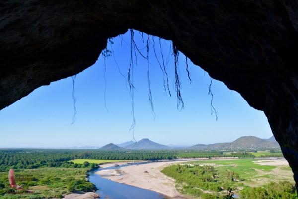
This week I learned from our friend, Joaquin Hernández, that Chametla—just 90 minutes from Mazatlán in the municipio of El Rosario—is the most important archeological site in all of northwestern Mexico! In Chametla are at least two pyramids built in pre-Hispanic times by the Totorames. Both were sacred sites, with platforms on top for sacrifices. Hernán Cortés himself visited Chametla, in 1535, before traveling over to La Paz; there are written documents and paintings that record this fact. Legend has it that he sat in the Cueva del Diablo looking out over the entire valley.
Near Chametla were 22 pre-Hispanic towns. What attracted so many Totorames to Chametla? The area is home to seven hills, which contain many caves. The Rio Baluarte runs through it; it’s very close to the Pacific Ocean; it’s fertile land; there’s jungle as well; and it’s right in the middle of the wonderful estuary system where historically mangroves and shrimp have thrived. In ancient times, there were three regions in southern Sinaloa: Sinaloa, Culiacán, and Chametla. Chametla comprised the territory from Escuinapa in the south to Piaxtla in the north. Only later was Mazatlán founded (on the present site of Villa Unión).
So, where are these pyramids? The first is the setting of the church in Chametla, at the foot of Cerro de San Pedro. I took some photos, but the pyramid is much easier to see live and in person. The church is built at the top, on the platform of the pyramid, while the lower part of the pyramid goes way beyond the church and down the hill. You can see that it’s man-made.
In 1935, when they were renovating the church, they found a secret passageway behind the altar that led to an underground cave. There they found “pagan” icons and relics, so the church quickly sealed it all back up. There was a second entrance to the cave just outside the church, at the entrance to where the original church was located. That cave entrance is now covered with a huge boulder. Click on any photo to enlarge it or view a slideshow.
Cool, huh? Not as visually stunning as a Chichen-Itza, by any means, as this pyramid has been built on and tweaked over and over throughout the millennia; it’s located right in the center of town. But, you can most definitely see its vestiges. The conquista of course was not just about conquering territory or even people; the conquistadores wanted to conquer the entire culture. So many churches are built on sacred sites of the indigenous peoples, as in Chametla.
And where is the second pyramid? It’s a 400-meter pyramid on which the local cemetery is built, also clearly visible. Local people say that when graves are dug, they almost always dig up pottery and other relics from the Totorame. The best specimens of these can be found in the small museum that is right next door to the church.
.


If you go to Chametla, I’d urge you to hike the 365 steps up El Cerro de la Cueva del Diablo. At the top is a man-made cave, obviously another sacred site, with a view of the entire river valley, estuary, ocean… The view is spectacular. It is in the cave that you’ll see an indentation that looks like two butt cheeks, and legend says that’s where Cortés sat. While he wasn’t in Chametla long enough to carve a seat, he may have enjoyed the gorgeous view, with the opening of the cave mirroring the curve of the hill it faces. On many of the hills in the area you’ll find platforms, indicating they were sacred sites; Loma de Ramírez has a 100 meter x 100 meter platform. The area is splendid for hiking, with a diversity of flora and fauna as well as elevation and lots of water.
.
.
Productive intensification and ideology in the marshes of Escuinapa, Sinaloa. Pre-Hispanic settlement pattern and ethnohistorical sources
by Luis Alfonso Grave Tirado (INAH Sinaloa/Mazatlán Archaeological Museum)
Productive Intensification and Ideology in the Salt Marsh of Escuinapa, Sinaloa. Prehispanic Settlement and Ethnohistorical Data
ABSTRACT. The salt marsh area of Escuinapa, Sinaloa, is part of the so-called Marismas Nacionales, an extensive network of coastal lagoons, marshes, swamps and mangroves in southern Sinaloa and northern Nayarit (Mexico). Thanks to the results of three field seasons of the Archaeological Project Marismas del Sur de Sinaloa and some rescue excavations, it has been possible to establish the prehispanic settlement patterns in the area of the municipality of Escuinapa. Two stages were recognized in which the occupation and exploitation of the estuary’s resources intensified, coinciding with the construction of ceremonial spaces precisely in the historically most productive areas, both in fishing and salt extraction. Such was the importance of these activities that those who practiced them had their own gods: the fishermen worshiped Nycanori and salt workers Narama. It is clear here the use of ideological mechanisms to intensify the production of estuarine resources.
.
Over the past 40 years, the Mexican Pacific coast has undergone a significant transformation due to the introduction of aquaculture techniques, particularly shrimp farms, which have noticeably impacted the coastline. The marshland area of southern Sinaloa, between the Baluarte River and the Teacapán Inlet, has been no exception; on the contrary, it is one of the most affected. Furthermore, in the 1980s, it was subjected to intense looting of shell middens (both natural and man-made) for the purpose of using shells as fill material in the construction of many of the local roads and the airport in Teacapán, a small fishing village [1] .
Partly due to this situation, the Southern Sinaloa Marshes Archaeological Project (PAMSS) was proposed in 2009. Between 2010 and 2014, three field seasons were carried out, every other year, all in the western part of the Escuinapa marshland area, including a portion of Palmito del Verde Island and the entire Teacapán Peninsula, as well as the western slope of Cerro del Muerto (Grave Tirado 2011, 2012b, 2015). The eastern area, meanwhile, was investigated at the end of the last century through archaeological salvage work related to the construction of the Villa Unión-San Blas highway (Grave Tirado 2000, 2005). In addition, some inspection visits have been carried out (Grave Tirado 2016a), so in recent years we have reviewed practically all of the Escuinapa marshes, with the exception of some islands.
Unfortunately, excavations have been carried out at few sites; even so, we are in a position to establish with some clarity the regional settlement pattern; that is, how the different archaeological sites relate to the surrounding landscape and their social environment, in other words, to other settlements and areas of economic and ritual activity. This will allow us to approach the understanding of certain aspects of the past, such as how the environment was exploited and the social and political organization under which this exploitation occurred; that is, how space was appropriated and used, how this same space was transformed into a cultural landscape (Prieto Rodríguez 2011), and even whether it was sacralized, or, to put it in the terms of Knapp and Ashmore (1999), how the environment was mediated by humans.
In sum, I agree with Sugiura Yamamoto (2009) that settlement pattern analysis is “a more efficient methodological and technical resource in terms of time, cost, and results, and perhaps the only one that allows us to obtain a better and more comprehensive understanding of regional history.” And in areas like northwestern Mexico, so far removed from the official budget, sometimes there is no alternative but to conduct only surface studies.
The marshes of Escuinapa
A distinctive feature of the state of Sinaloa is the narrowness of its coastal plain (considering this as the strip between the Pacific Ocean and the 150 meters above sea level of the Sierra Madre Occidental); this narrowness, however, is much more pronounced in the southern extreme, where the flat area barely exceeds 20 km in width, a good part of which is covered by wetlands that make up the so-called Marismas Nacionales (Figure 1).
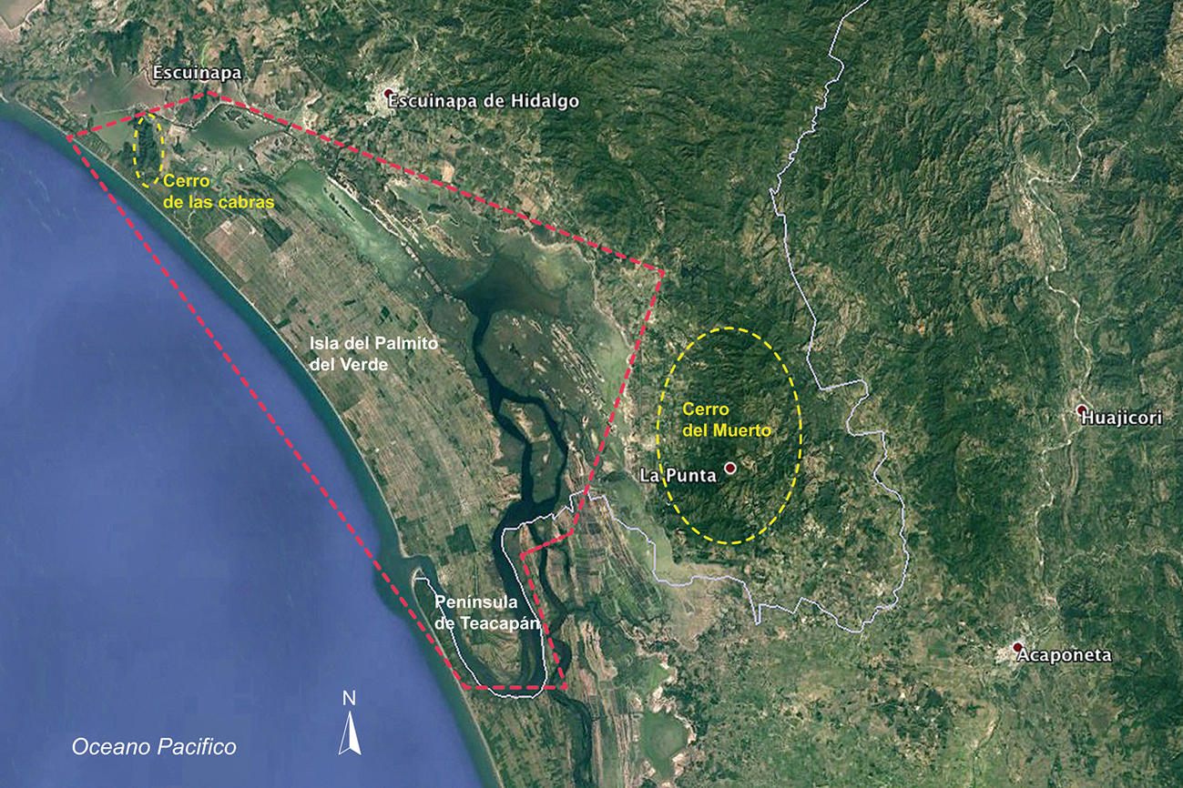
Figure 1. The marshland area of Escuinapa, Sinaloa (© Google Earth image, 22°41’08.97”N 10538’58.73”, modified by the author [DAO Richard Bertaux]).
The estimated area of wetlands is currently 38,670 ha, of which only 5,540 (14%) are permanently flooded. The rest is susceptible to flooding only during high tides and especially during the rainy season (Ramírez Zavala, Cervantes Escobar and Tapia Hernández 2012: 120-121); however, 50 years ago the subtidal zone was almost 16,000 ha (Ramírez Zavala, Cervantes Escobar and Ramírez Zavala 2012); and it was probably even more extensive in pre-Hispanic times (Foster 2017b).
However, even areas that remain flooded year-round, such as the Agua Grande lagoon, are very shallow, since communication with the sea occurs through narrow, winding channels that mitigate the effect of the tides. On the other hand, most of the freshwater inflow occurs during the rainy season and is practically nonexistent during the dry season, resulting in high salinity (Cervantes Escobar and Ramírez Zavala 2012: 44; Ramírez Zavala, Cervantes Escobar and Ramírez Zavala 2012: 67-68). These characteristics, however, have allowed the development of diverse habitats such as “intertidal vegetation, marshes, sandy beaches, muddy bottoms, permanently submerged vegetation, rocky and shell reefs, planktonic communities and mangrove vegetation, among the most notable” (Ramírez Zavala, Cervantes Escobar and Ramírez Zavala 2012: 75).
The mangrove deserves special mention [2] , as under its shade a large number of animal species develop that are susceptible to exploitation both now and in pre-Hispanic times: at least 61 species of fish, among which we can mention the sierra (Scomberomorus sierra) , the chihuil or catfish ( Bagre panamensis , Arius seemani ), the lisa ( Mugil curema , Mugil cephalus ), the pargo ( Lugnatus sp.), the snook (Centropomus sp.), the curvina ( Cynoscion sp.) and several mojarras; as well as various shelled mollusks, including oyster (Ostrea corteziensis) , pata de mula ( Anadara grandis and Anadara tuberculosa ) and clams ( Tivela byronensis and Chione californiensis mainly), and crustaceans such as the crab (Callinectes sapidus) and the white shrimp (Litopenaeus vannamei) .
The region is also an important bird sanctuary and, according to the National Commission for the Knowledge and Use of Biodiversity (CONABIO), “regularly hosts more than 70,000 waterfowl and 104,000 shorebirds.” Among the former, several species of ducks, herons, and moorhens stand out, and the American avocet (Recurvirostra americana) is prominent among the latter; in addition to hawks, the military macaw (Ara militaris) , and parakeets (Forpus cyanopygyus) ; although a total of 396 species have been identified.
Meanwhile, on the island between the sea and the lagoon system (the so-called Isla del Palmito del Verde [3] , to which the Teacapán peninsula belongs), although the sandy soil does not allow for the presence of surface water, it does contain an underground aquifer of almost 267 km² , with a storage volume of 21.7 million m³ , which is replenished each rainy season (Ramírez, Cervantes Escobar, and Ramírez Zavala 2012: 81). Freshwater is less than one meter deep, making agricultural practice possible through the construction of ponds (jagüeyes).
The development of efficient fishing and salt production techniques
The high productivity and importance of fishing and salt production in the Marismas Nacionales area are clearly demonstrated by the development of highly efficient artisanal fishing systems. For fishing, one such system is known as “tapos” or “cierras,” which consists of a structure of forked posts that completely spans one of the narrow estuary channels. These posts support a type of folding curtain traditionally made of otate (Gadua amplexifolia) poles , but since at least the 1970s, palm petioles have been used instead, and in recent years, PVC pipes have also been employed. The intention is to create an opening between the poles that allows the entry of shrimp postlarvae (5 to 12 mm) while preventing juvenile shrimp of at least 120 mm from escaping and returning to the sea (Macías-Regalado and Calderón-Pérez 1980). Using the same otate poles, semi-enclosed spaces about two meters in diameter called “chiqueros” were constructed where the shrimp congregated and from where they could be harvested using net “spoons.” To prevent the nets from getting stuck in the mud, the bottom of the chiquero was filled with mollusk shells, although gravel is now used. The fisherman stood on a platform called a tapeste (Figure 2).

Figure 2. The “tap” of El Mezcal. Note the use of PVC pipes (© author’s photograph).
Although this technique reached its peak between the 1930s and 1980s, with up to 99 traps identified in the Marismas Nacionales region, 43 in Nayarit, and 56 in Sinaloa, yielding up to three thousand tons of shrimp (Chapa Saldaña 2007), it has pre-Hispanic origins [4] . The first mention of it appears in one of the accounts of Nuño de Guzmán’s conquest of Nueva Galicia between 1530 and 1533. The chronicle is attributed by J. L. Razo Zaragoza (2001) to Pedro de Guzmán, but J. García Icazbalceta (1980) originally published it as the Second Anonymous Account of Nuño de Guzmán’s Journey to Nueva Galicia . In any case, the chronicler had participated in the advance of the Spanish troops towards the Yaquimi River in 1533 and his return notes:
This town of Coliacan is called San Miguel: it is populated in a valley called Horabá, two leagues from the sea: the floodwaters rise to the town itself, through a river that passes through it: the river is stopped there with a wattle and daub of reeds, and they make a device for catching fish, so that even if there were another Seville there, it would be enough to supply itself with what is caught there of mullet and other kinds of very good fish. (Razo Zaragoza 2001: 282)
It is likely that “the river” refers to one of the estuary channels that once extended as far as the present-day town of Costa Rica in the Culiacán Valley, the original site of the Villa de San Miguel (see Ortega León and Grave Tirado, in preparation). The most detailed description of this system, however, is that of Bishop Alonso de la Mota y Escobar, who served as inspector at the end of the 16th century and refers specifically to southern Sinaloa:
The manner and time in which these Indians go fishing is in this way: they wait and attend to the waxing moons of November, December, and January of each year, in which, when the sea rises and enters through this river, a great quantity and diversity of large and small fish enter together to spawn in this river, and they commonly enter at night and not on the surface but through the depths of the water. The Indians are so skilled that, with their ear placed on the surface of the water, they feel and perceive the noise that the fish make at the bottom of the river as they pass. And at this time when the school of fish is rising upstream, the Indians are very quiet and calm, and when they realize that the rising tide is about to recede, they quickly throw out some reeds that they have ready, with which they block the entire river from bank to bank, and it reaches and touches the ground below, and they tie it tightly on both sides of the land. These weirs are made of thick, strong reeds, so tightly joined and fastened together that nothing but water can pass through them. Thus, when the tide rises and the sea returns swiftly to its natural basin, it carries with it the river’s waters, along with the great multitude of various fish that had flowed upstream. When they reach this sluice gate and barrier, the waters pass on, trapping the entire fishery, which, with the river’s outflow, is left almost completely dry. […] These operations, as mentioned, are carried out two or three times a year in large quantities, and such a quantity is caught that it supplies the entire kingdom of Galicia, and a large part of New Biscay and New Spain, with essential fish . [5] (Mota and Escobar 1966: 43-44)
Salt extraction, for its part, is not mentioned in the earliest documents, but it is highlighted in the late 16th and early 17th centuries. One of the few mentions comes from Bishop Mota y Escobar himself (1966: 43), who points out that in Chametla, salt “[…] is produced very close to here in some estuaries that come out of the sea, which when they dry out crystallize and become salt”; and in some of the saltworks, “[…] two thousand hanegas were produced each year” (ibid.: 42) [6] .
A document from 1608 specifies the location of the saltworks in the province of Chametla: “about six leagues from the promontory of Ichquinapan” ( Apud , Moreno Martínez 2010: 4). For his part, Lázaro de Arregui (1946: 104) describes the technique used in 1621: “which is obtained by making small ponds where the water that enters from the tides crystallizes, and in this way they usually produce 20,000 fanegas of salt some years”; that is, between 1,110 and 1,816 tons. We cannot be certain that this technique has a pre-Hispanic origin, but it is still in use today, although only the El Quarrán saltworks remains (Figure 3).

Figure 3. El Quarrán salt ranch (© author’s photograph).
Archaeological investigations in the marshland area. Pre-Hispanic settlement pattern
The Escuinapa marshes are perhaps the most archaeologically investigated area in the entire state of Sinaloa, although their study began relatively late. Between 1967 and 1975, the National Marshes Project of the State University of New York at Buffalo was carried out , within which archaeological, ethnohistorical, ecological, and geomorphological investigations were conducted in the marshland area between the towns of Escuinapa, Sinaloa, and Cuautla, Nayarit (Foster 2017a; Scott 1974a and b, 1985, 1999; Scott and Foster 2000; Shenkel 1974).
In this relatively small area (140 km2 ) 594 pre-Hispanic archaeological sites were located [7] , of which the vast majority (557) correspond to oyster shell middens (Ostrea corteziensis) ; while only twenty are made up of clam shells (Tivela byronensis) , four of mule’s foot (Anadara grandis) and thirteen settlements that, in addition to accumulations of clam or oyster, present mounds of earth (Foster and Scott 2017b).
Unfortunately, neither the description nor the map (nor the reports nor R. Shenkel’s 1974 article) indicates the precise location of the oyster shell middens, so we don’t know what percentage of the 557 were located in Sinaloa. We do know that of the 20 clam middens, eight were located on the western edge of the Teacapán Peninsula, in Sinaloa, as well as the four mule’s foot middens, which are on the shores of the Agua Grande lagoon, in the municipality of Escuinapa. Finally, of the 13 settlements with earthen mounds, five are in Sinaloa: four directly on the edge of the marsh: El Mirador, Venadillo, Cristo Rey, and La Tarjea, and one more (Juana Gómez) on the coastal plain, but less than five kilometers from the marsh area.
The last one stands out due to the complexity of the arrangement of its nine mounds, which were distributed in two groups: one of seven mounds in the southwest grouped around a plaza, with the main mound more than five meters high. The other group is to the southeast and only had two mounds (Figure 4) [8] .
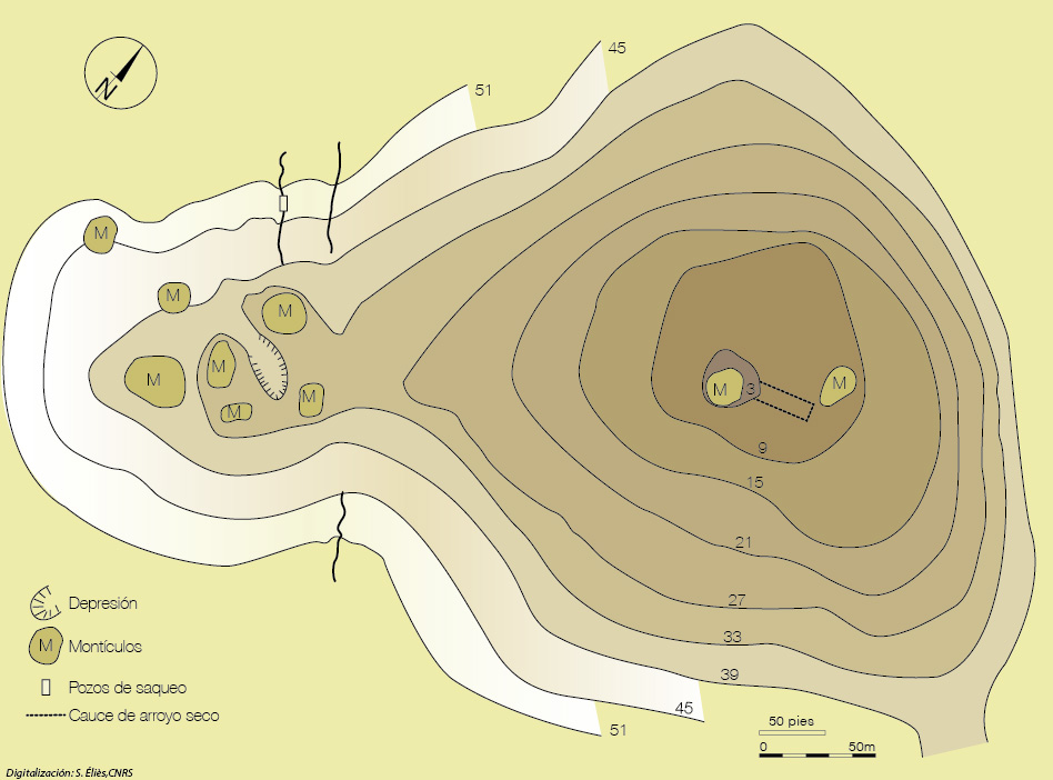
Figure 4. Topographic map of Juana Gómez (© modified from Wolynec et al. 1968 [DAO Sylvie Éliès]).
Foster and Scott (2017a) recognize two main occupation phases in Marismas Nacionales: the Estero period (300-700 CE), typified by clam shell middens, to which the entire settlements of Juana Gómez [9] and La Tarjea and one of the El Venadillo mounds correspond, as well as areas of four other sites in Nayarit. After the Estero period, they note an abandonment between 700 and 900 CE, due to continuous flooding, followed by the Conchera period (900-1531 CE), to which the 557 oyster shell middens and the rest of the earthen mounds correspond.
Special mention should be made of El Calón (Figure 5), one of the four archaeological sites whose main component is the shell of Anadara grandis . El Calón is distinguished from the other 580 shell middens located in the Marismas Nacionales Project by both its architectural characteristics and its chronology. El Calón is a truncated cone more than 80 m in diameter at the base and more than 20 m high, constructed entirely of mollusk shells, most of them indeed of the Anadara grandis species .
Based on radiocarbon dates for five of the shells, Foster and Scott conclude that it was erected between 2400 and 2200 BC, with at least one enlargement between 1600 and 1200 AD (2017a), which would make it the earliest monumental structure in the Americas [10] . However, other participants in the Marismas Nacionales Project, such as R. Shenkel (1974), who was directly in charge of the exploration of El Calón, and D. Cottrell (1972), based on the geomorphology of the area, consider that it was built between 700 and 1000 AD.

Figure 5. Plan of El Calón with the location of the excavation units (© drawing by the author).
With one of its objectives being to resolve this question, the El Calón Archaeological Project was launched (Grave Tirado 2003, 2006). Both the truncated cone and the platform were explored (Figure 5), and it was determined that their construction was planned and occurred at a single stage. Furthermore, despite the frustrating scarcity of archaeological materials, two anthropomorphic figurines of the “White Bathed” type were found, allowing us to establish that it was used, if not constructed, between 500 and 750 AD.
Finally, as part of the archaeological salvage work for the construction of the San Blas-Mazatlán highway (Grave Tirado 2000, 2005), nine settlements were recorded on the shores of the marsh [11] , but curiously only two of them (valle de la Urraca and the island of Huanacaxtle) are shell middens and both are located in the interior of the estuaries, on separate islets. The rest are located in the flat area between the brackish waters and the mountains and were basically occupied by farmers who also fished, since, at least in the three that were explored through excavations (San Miguel La Atarjea, Las Lomitas and Las Mulas), fish bones, crab claws and clam shells (Tivela and Chione) , mule’s foot (Anadara grandis) and oyster (Ostrea corteziensis) were recovered , some of the latter with clear evidence of having been subjected to the smoking process.
The two largest sites, San Miguel La Atarjea and Las Lomitas, feature earthen mounds and were occupied between 250 and 1100/1200 AD, while the remaining sites, including the two oyster shell middens, were occupied between 1100/1200 and 1531 AD.
Thus, by the end of the first decade of the 21st century, we had data indicating sustained use of the estuary’s resources both within the lagoon system and from inland sites; however, the existence of El Calón led us to question the intensity of its exploitation. To answer this and other questions, the Southern Sinaloa Marshes Archaeological Project (PAMSS) was implemented.
The Southern Sinaloa Marshes Archaeological Project (PAMSS)
Although this project prioritized documenting pre-Hispanic remains, it also sought evidence from the colonial period and from modern and contemporary Mexico. When possible, informal interviews were even conducted with fishermen and salt producers who still practice traditional techniques.
The area surveyed covers approximately 155 km² , where 182 archaeological sites have been recorded. Of these, 136 are from the pre-Hispanic era, only one could be definitively dated to the Colonial period, and two to the 19th century. Conversely, 22 correspond to the 20th century (mostly saltworks), and 12 are contemporary, including three dams and one saltworks still in operation. Here, we will focus on the pre-Columbian period.
Of the 136 sites, 55 are oyster shell middens and 32 are clam middens; 37 settlements feature small earthen mounds, 14 of which also contain accumulations of shells. Four of the sites were established as saltworks, and three other sites were located on the shores of the Agua Grande lagoon with architectural structures built with mollusk shells, particularly the abalone (Anadara grandis) ; in addition to five settlements on hills, four of which appear to have functioned as ritual spaces, three on Cerro del Muerto and one on Cerro de las Cabras (Figure 6).
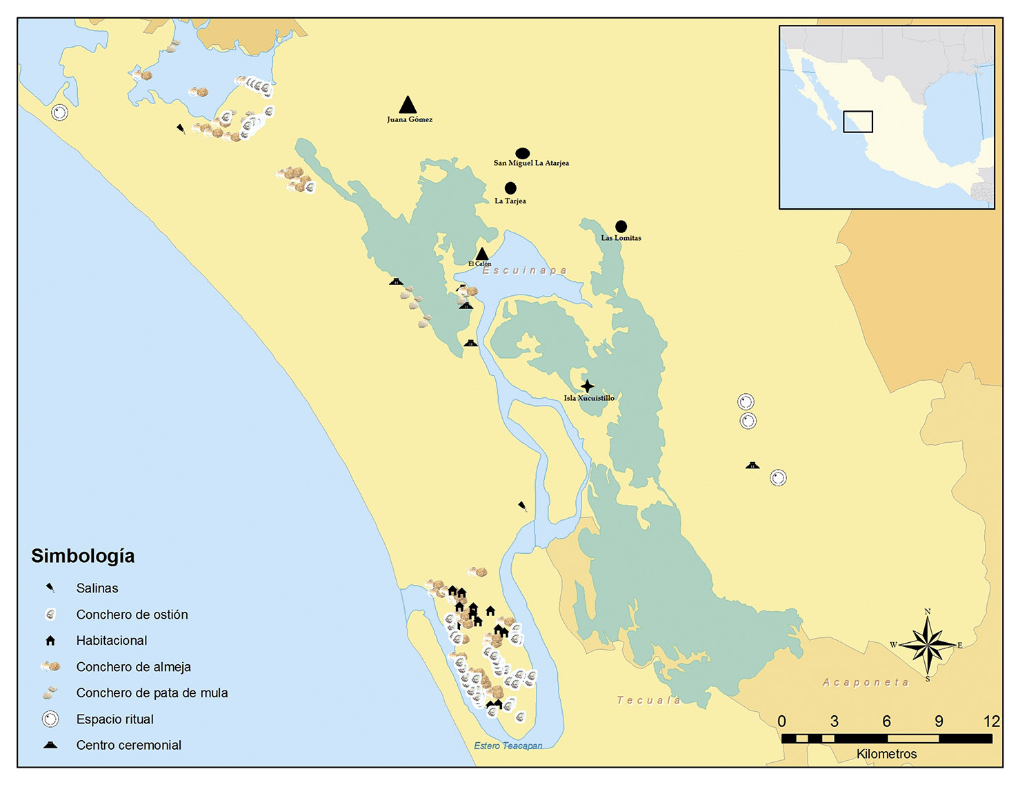
Figure 6. Map with the sites registered in the PAMSS and other settlements mentioned in the text (© drawing by Cinthya Vidal, modified by the author).
Most clam shell middens are located on the Teacapán Peninsula. Although they are generally small, no more than 30 m in diameter and less than 1 m high, two (MSS-158 and MSS-162) were found on the shore of the Los Malines estuary, opposite Cerro de las Cabras. These middens are linear, extending for just over 1.5 km, although in some areas the shell is only superficial, while in others it is more than a meter thick. While those on the Teacapán Peninsula consist of Tivela byronensis , those at Cerro de las Cabras also contained the species Chione californiensis , and even some Anadara grandis , A. tuberculosa (mule’s foot clams), and Ostrea corteziensis (oysters). Nevertheless, all of them correspond to the Baluarte phase (500-750 AD).
For their part, most of the oyster shell middens are also located on the Teacapán Peninsula, with only a few in the area surrounding Cerro de las Cabras. In this latter location, site MSS-148 stands out, measuring over 120 m in diameter and exceeding one meter in height in some areas; the other 36 sites average 35 m in diameter and range in height from 1 to 3 m. The dominant, almost exclusive, species is Ostrea corteziensis , and the chronology of all sites was established within the Acaponeta (900-1100/1200 CE) and El Taste-Mazatlán (1100/1200-1531 CE) phases, with a greater presence of materials from the latter.
Of the 37 sites with earthen mounds, 32 are located on the Teacapán Peninsula in slightly elevated areas that are not flooded with brackish water, and the rest are in the area surrounding the Agua Grande lagoon. Almost all consist of one or two small hills, sometimes associated with shell middens. The sites designated MSS-21 Sarmiento I and MSS-23 Sarmiento II are particularly noteworthy. The former covers almost 36 hectares and has 14 earthen mounds and 3 clam middens; while Sarmiento II has 20 earthen mounds and covers more than 60 hectares (Figure 7). However, both were interpreted as scattered hamlets, with cultivated areas interspersed among the houses. Both were inhabited during the Baluarte phase (500-750 AD) and although the first was reoccupied in the El Taste-Mazatlán phase (1100/1200-1531 AD), the second was not. In fact, 20 of the 37 residential settlements were occupied between 500 and 750 AD, of which only 3 were reoccupied in the Acaponeta phase (900-1100/1200 AD) and from that moment on another 17 sites were inhabited, which remained occupied until the arrival of the Spanish.

Figure 7. Sketch of the MSS-23 Sarmiento I site (© drawing by the author).
The presence of grinding stones, axes, and spindle whorls, as well as pottery and chipped stone artifacts, along with their location, at these sites indicates that part of their subsistence depended on agriculture, despite the absence of surface freshwater in the area. In fact, it could be argued that the presence of these materials does not necessarily prove that crops were cultivated in this area, since agricultural products could have been obtained through trade with settlements on the plains and in the Baluarte River basin, or even, in the case of the spindle whorls, through the harvesting of wild cotton, which is relatively abundant in the marshland. However, it is important to remember that freshwater is abundant underground and is found at a depth of less than one meter. Is it possible that they accessed it by constructing water reservoirs, as is common practice today [12] ? We do not know. The settlement pattern indicates the existence of a permanent or semi-permanent population in areas suitable for cultivation. However, it is certain that the diet was supplemented by fishing, shellfish gathering, and bird hunting.
The other important activity in the marshland area was salt extraction; however, of the 55 saltworks registered so far in the PAMSS (Marshland Archaeological Park), only four show pre-Hispanic evidence. Panzacola is a special case, because unlike the other saltworks where the earth mounds resulting from the construction of the salt pans are randomly distributed, here they show a clear order (Figure 8), leading me to believe that, in addition to being a saltworks, it also functioned as a small ceremonial center. Supporting this interpretation is its location between Cerro del Muerto to the east and Cerro de las Cabras to the west. And it is not the only one.

Figure 8. Sketch of Panzacola (MSS-114) (© drawing by the author).
Productive intensification and ideology
We have already seen that El Calón is also located in these conditions. It consists of a single, uninterrupted structure that culminates in a quadrilateral surface measuring 12 x 11 m, which is more or less level—or at least that was the original intention. However, due to erosion, it now has a slight slope on all four sides. Its base measures 85 m from east to west and 88 m from north to south, and with a height of almost 21 m, it is a truly monumental building in the middle of the marsh (Figure 9). A pregnant ceramic figurine and three small stone phalluses were found at its summit. Its interpretation as a temple seems beyond doubt (Grave Tirado 2010).

Figure 9. Photo of El Calón. In the background, the Cerro del Muerto can be seen (© photograph by the author).
In the immediate vicinity of Agua Grande Lagoon, we recorded three other settlements with architectural structures also built from mollusk shells. At least two of them feature monumental buildings. MSS-96 El Macho is a platform measuring 40 by 15 m at its base and nearly 6 m high, which stands out clearly in the middle of the marsh. MSS-95 Isla del Macho, while its structures are smaller, exhibits greater complexity. To the southwest is a U-shaped or horseshoe-shaped structure, almost 45 m on each side, with walls just over 8 m wide and nearly two meters high. To the northeast is a platform measuring 70 by 30 m, upon which stands a possible ballcourt and two small mounds (Figure 10).

Figure 10. Sketch of the Isla del Macho site (MSS-95) (© drawing by the author).
Unfortunately, the only materials recovered from these sites are flakes of green mud obsidian and some polished stone tools, so we have no evidence to even establish their relative chronology. However, given that ballcourts at neighboring sites such as Amapa (Meighan 1976) and Chametla (Grave Tirado 2017a) date from after 750 CE, I am inclined to consider them late [13] . In any case, their presence does allow us to glimpse the importance of fishing and salt extraction in pre-Hispanic times, which led to the construction of these ceremonial spaces in what we can consider the heart of the marshland area and precisely in the same area where the largest number of saltworks and dams have historically been concentrated.
In the worldview of pre-Hispanic Mexico, east and west were the most important directions, but north and south were also significant. To the north of these sites is Cerro del Yauco, another of the region’s representative hills, and to the south is Boca de Teacapán, where the waters of the estuary meet the sea. If we draw a line between Cerro del Muerto and Cerro de las Cabras (east-west) and another between Cerro del Yauco and Boca de Teacapán (north-south), at the center of the cross lies Laguna Agua Grande, and with it, El Calón, Isla del Macho, El Macho, and Panzacola, forming the center of the axis mundi (Figure 11).

Figure 11. Map showing the location of the ceremonial centers of the Escuinapa marshes in relation to the landscape elements (© modified on INEGI map Escuinapa F13-5).
In the Colonial era, each of the principal gods of the region had their dwelling place in a specific point of the landscape: “They pretended that the table was the Sierra, the statue of Pyltzintli its seat the sun,” that of Nicanori an arm of the sea, that of Narama a hill they call “horse’s head” and by another name Ychamet which means the House of Maguey and Mezcal, that of Uxxu a rock that is inside the sea…” (Arias and Saavedra 1990: 300). Pyltzintli was the Sun, Uxxu was a goddess of fertility, Nycanori was worshipped by fishermen and bird breeders, and Narama was worshipped by salt workers, those who made wine or pulque and planted chili peppers (ibid.: 209-300).
Currently, the indigenous people of the Sierra del Nayar still conceive of the world as a quincunx with the four directions and the center marked by prominent elements of the landscape (Coyle 2003; Jáuregui and Magriñá 2016; Neurath 2003a, byc); however: the east-west axis has preeminence over the north-south axis.
Exactly on this quincunx axis in the marshland area, but on the other side of the Agua Grande lagoon, an offering was recently discovered accidentally on Xucuistillo Island (Grave Tirado 2016a). It consists of two relatively small bowls (14 cm in diameter by 5 cm high) and five anthropomorphic figurines (Figure 12). The first two are of the “Medium Polychrome Chametla” type, while the figurines correspond to the “Painted White Bath” type, both indicative of occupation between 500 and 750 CE.
The five figurines are seated. Three of them are directly “on the ground” and are female. One has her breasts exposed, and the other two have a kind of mantle spread out in front of them. The other two are male and are seated on stools, one circular and the other quadrangular. In addition to headdresses and necklaces, they wear a kind of loincloth, reminiscent of the hip protectors worn by ballplayers. An offering in an ancient space for playing the ballgame [14] ?

Figure 12. Components of the Xucuistillo Island offering (© photograph by the author [DAO Sylvie Éliès]).
In other words, increased production and the construction of places of worship occurred more or less simultaneously, indicating that one group was already superior to the others [15] ; and this small group was the one that must have encouraged the production of surpluses. Power, according to H. Claessen (1979: 7), is nothing more than “the capacity to impose one’s own will on others.” For his part, M. Weber (1977: 45) states: “Generally speaking, we understand ‘power’ to be the possibility for one or more people to carry out their own will in a common action, even against the opposition of other participants in the action.” To achieve this, force is not always used; threats, manipulation, influence, and authority are also employed, and most of the time this is sufficient. In fact, by exercising physical force, rather than demonstrating power over another person or persons, one reveals a scarcity or even a lack of power over them (Luhman 1995).
So, if force alone wasn’t enough, how were the fishermen, salt workers, and shellfish gatherers of the Escuinapa marshes compelled to produce surpluses? Initially, it may have been through force; however, for long-term control to be effective, ideological mechanisms were necessary. Ideology is “the set of ideas, beliefs, concepts, and so on” presented as common to the entire society, but which in reality belong to the ruling group to legitimize its dominance over the rest of society (Zizek 2003). Archaeologically, ideology is materialized through monuments, symbolic objects, and iconography (Earle 1997: 151); these are indicators of public ceremonies.
The location and orientation of El Calón leave no doubt about its function: it was a stage for collective celebrations (Grave Tirado 2010). Furthermore, the construction of this enormous truncated cone involved a massive investment of labor, as we calculated that 275,746,791.5 shelled mollusks were needed, requiring a well-established organizational capacity.
Thus, ideological manipulation continued to play a significant role in the commercial exploitation of the estuary, primarily through the periodic celebration of collective festivals. In this regard, it is noteworthy that precisely where the most important festival in the municipality of Escuinapa, the Fiesta del Mar de las Cabras [16] , was celebrated until half a century ago, there is evidence of a pre-Hispanic ritual space (Grave Tirado 2016b). The festival is celebrated during the third week of May, practically at the end of the salt season and the beginning of preparations for planting.
Meanwhile, among the remains of the sites destroyed in Teacapán in the 1980s, some elements were recovered that indicate the presence of elite groups, related at least to the ruling group. One is a vessel with Codex-style decoration depicting a possible deity (Figure 13) [17] and the other is a batch of 1699 Spondylus shell beads and 223 greenstone beads, two of which appear to be turquoise (Figure 14) [18] .

Figure 13. Codex-vessel that probably comes from the marshland area (© private collection, photo courtesy of Mauricio Garduño [DAO Sylvie Éliès]).

Figure 14. Lot of shell and greenstone beads recovered at a site on the Teacapán peninsula (© INAH Sinaloa archive, photograph by Israel Cristian Pérez Herrera).
The possession of Codex-type vessels was a clear indicator of high social status in pre-Hispanic Mexico, at least among the Maya (Caso Barrera and Aliphat F. 2008; Fierro Padilla 2016). It is also well known that in ancient Mexico, shell and greenstone necklaces were part of the regalia of high-ranking individuals, whether rulers, priests, or warriors (Ekholm 2008; López Mestas Camberos and Ramos de la Vega 2006; Olguín 1994, to mention a few examples from Western and Northwestern Mexico).
In the 16th century, the warriors of Chametla adorned themselves “with many feathers, shells, snails, and seashells” (Obregón 1988: 102-103). Likewise, in plate 67 of the Lienzo de Tlaxcala (Chavero 1979), which depicts the battle of Chyametlán [Chametla], one of the Chametlan warriors wears anklets with beads. He is the only one with an elaborate feather headdress, dressed in a xicolli ( a type of tunic), and wearing a large nose ornament, which undoubtedly reinforces his identification as a warrior chief (Olivier 2015: 514-565 and 587-588). Furthermore, it is worth noting that some of the figurines from Xucuistillo Island seated on thrones (another symbol associated with power) also wear necklaces and headdresses.
Final comments
In the Escuinapa marshland area, 160 pre-Hispanic archaeological sites have been recorded [19] (Table 1). Of these, 41 correspond to clam shell middens, 56 to oyster shell middens, 49 showed residential mounds (sometimes with associated shell middens); seven sites have architectural structures built with mollusk shells, particularly mule’s foot shells, four saltworks, and three ritual sites.
Table 1. The marshland archaeological sites recorded in each project and their tentative chronology (© prepared by the author).
| Project/Site Type | National M Project (1967-1975) | San Blas-Mazatlán Project (2000 and 2005) | PAMSS (2010-2014) | Inspection visits | Total | Main timeline |
| Clam shell middens | 8 | 32 | 1 | 41 | 500-750 AD | |
| Oyster shellfish beds | ¿? | 1 | 55 | 56? | 900-1531 AD | |
| Mule’s foot structures | 4 | 3 | 7 | 500-750 dC 900-1100/1200 dC | ||
| Residential (earth mounds) | 5 | 7 | 37 | 49 | 250-500 AD 500-750 AD 750-900 AD 900-1531 AD | |
| Salt mines | 4 | 4 | 900-1531 AD? | |||
| Rituals | 1 | 1 | 1 | 3 | 500-750 AD? | |
| TOTAL | 17 | 9 | 132 | 2 | 160 |
Occupation began around 250 AD in the eastern zone, that is, the flat area between the marshes and the mountains, the most suitable zone for agriculture. The largest settlement from this period is Juana Gómez, which even has a small central plaza. Later, between 500 and 750 AD, the small Teacapán peninsula was also inhabited, and although agriculture was likely practiced there as well, its location is more related to fishing and shellfish gathering. This is when the more or less intensive exploitation of clams began, and the construction of El Calón also dates to this period, suggesting that fishing intensified as well.
During the period from 750 to 900 AD, the western part of the marshes became practically uninhabited, with only four settlements remaining occupied. In contrast, although the population decreased, the eastern area remained occupied [20] .
Between 900 and 1531 AD, even though the eastern zone was practically depopulated, the Teacapán peninsula was reoccupied and the exploitation of the estuary’s resources increased; the clearest evidence is, of course, the large number of oyster shell middens, although it is likely that the rest of the shell architectural structures are from this period, as are the saltworks sites, particularly Panzacola.
In summary, the occupation of the Escuinapa marshes began sometime between 250 and 500 CE, and the exploitation of their resources took place between 500 and 750 CE. A notable decrease followed between 750 and 900 CE, with further intensification from 900 CE until the arrival of the Spanish. The settlement pattern suggests that the intensification of production was encouraged by the ruling group through the celebration of collective festivals, likely at the beginning and end of the fishing and salt extraction seasons, which roughly correspond to the rainy and dry seasons, respectively.
In this sense, the location of the ceremonial centers in relation to the sunrise on the summer solstice at Cerro del Muerto and the sunset on the winter solstice at Cerro de las Cabras becomes relevant. Both events still mark the beginning and end of each season among the indigenous groups of Nayar. The execution of these ceremonies makes the person who performs them, usually a member of the group in power and sometimes the ruling head himself (Grave Tirado 2017b), the guarantor of the continuity of the world [21] .
Even so, the order breaks down and El Calón ceases to function and for a time (750-900 AD), the occupation and exploitation of the Escuinapa marshes decreases, although not in the neighboring area of the lower basin of the Baluarte River where the population increases and the institutionalization of power is accentuated (Grave Tirado 2017a), which implies a political readjustment.
However, from 900 AD until the arrival of the Spanish, the islands were once again extensively occupied and exploited even more intensively than before. New ceremonial centers were also built (Isla del Macho and Panzacola).
However, neither Juana Gómez nor any other site in the marshes in any of the different periods meets the necessary conditions to have been the seat of a power capable of erecting El Calón and the rest of the ceremonial centers, and, on the other hand, the southern region of Sinaloa-northern Nayarit and in general the entire northwestern coast was divided throughout its pre-Hispanic history into small territorial units (Figure 15), with a fairly limited area of political influence (Grave Tirado 2012a; Ortega León and Grave Tirado 2018, in preparation).
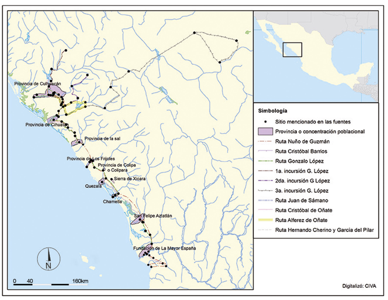
Figure 15. Map showing the provinces on the Nayarit and Sinaloa coast at the time of the arrival of the Spanish (© drawing by Cinthya Vidal).
Now, if we consider that they are located almost in the center of the southern Sinaloa-northern Nayarit region, a culturally and linguistically homogeneous area since it is possible to reach it by water from practically any point within it, could this be one of those strange cases of cooperation between politically autonomous groups, with these spaces having been built and used by all the small political-territorial units? That is, they would have functioned as a kind of sanctuary, that is, a sacred space of “collective recognition and convocation, which become centers of the ethnoterritories” (Barabas 2003: 25).
The existence of these types of sanctuaries is historically documented. During the Colonial period, the Nayarit settlement of Tzacaymota, although located in Cora territory, was also visited by Tzanames, Huichols, Tepehuanes, Vigitecs, and Totorames, and it was “[…] a common belief that all the native peoples of this land send offerings to this temple of Nayarit, the first fruits of all their harvests” (Arias and Saavedra 1990: 305). Ceremonies were also held there, “with many rancherías gathering (on the March moon)…, for which they hold many dances and celebrations that they call mitotes” (ibid.: 293). Furthermore, in the main town of the marshland area in the 17th century, Olyta, located precisely at the mouth of the Teacapán River, propitiatory ceremonies for a good catch were still performed.
It is customary in the town of Olyta at the beginning of the waters, for all the natives and elders to gather and choose the most worthy one as captain or atzaquani (to close the waters of the shrimp fishery)… and when it is time, which is recognized by the entrance of the sun, that it is the Nycanori or in their natural language, which is the totorame Yequi, which they interpret in the Mexican language quihaihuini, which is rainmaker and creator of the waters and the fish. The captain then immediately fasts for five days, during which he eats neither salt nor chili and remains chaste throughout the harvest, believing that if the shrimp is to die, he offers after the fast a ball of cotton seeds wrapped in twine and hanging from it some red heron feathers, and as he goes to bed at night he says these words: Neamoc, tamex yequi, which mean: “Lord, son of the rain god and creator of birds and fish, give us shrimp,” repeating these words many times, with which they say he appears to him in dreams and answers him: Amyn Moctanex Noxuu, which means: “Friend, I will give you shrimp,” and in the morning he informs the people, giving an account of what happened, and then they discuss their fishing, offering in the waters wine that they call Alasán and other things, and the first one to go fishing is the said Atzaquani, who, after he takes out the first shrimp, they prepare a cup for him, a drink that they call Paxnal; who takes the shrimp that fit in his hand and throws them into the Paxnal and drinks and gives what is left over to the dogs (ibid.: 305-306).
And the production of shrimp and fish was so great that they could trade with nearby regions and even with distant areas. A. de la Mota y Escobar (1966: 42) says, for example: “they catch a lot of snook, shrimp and clams, which supply all the mining towns and other surrounding villages, and for this reason the Indians here have some wealth”; and L. de Arregui (1946: 98) adds: “and even to Mexico City, despite being 150 leagues away, they take shrimp from this province.”
Thus, through the settlement pattern, several of the processes that occurred in the Escuinapa marshes in the pre-Hispanic era could be glimpsed, from confirming a permanent occupation, its fluctuations over time; the intense exploitation of resources, but also how through ideological mechanisms productive intensity was fostered in the Escuinapa marshland area in the pre-Hispanic era [22]
Notes
[1] Indeed, during the governorship of A. Toledo Corro (1981-1986), this airport was built almost exclusively for the private use of the governor himself and his friends (Ortiz Pinchetti 1983). It is currently under the protection of the Mexican Navy, and we were not allowed access to verify the shell fill.
[2] As in the rest of the Mexican Pacific, there are four species of mangrove, although the dominant one is the red mangrove (Rhizophora mangle) and on the shores there is the black mangrove (Avicennia germinans) , the white mangrove (Laguncularia racemosa) and the so-called false mangrove or buttonwood (Conocarpus erectus) .
[3] Although it is not exactly an island, at least since colonial times it has been called that.
[4] “Where preservation of perishable material is poor, ethnographic analogy together with ethnohistorical data are the means by which archaeologists can shed light on the ancient subsistence activities in aquatic environments” (Williams 2009: 608).
[5] The chronicles refer to another technique, that of poisoning. For example, Lázaro de Arregui notes that in the fisheries of Chametla in 1621: “The herb that is very profitable for food and farming is what they call barbasco, which comes in many forms and in abundance, and the one most used here is the root of some medium-sized plants, very similar to licorice, although the leaves are whiter. And with four loads of this root, a man goes with six or eight young men to the mouth of a small river or estuary, and blocking the mouth with a net of thread or branches, he throws the crushed barbasco into the river or estuary as far as it can reach when the sun is already hot, and within an hour it intoxicates all the fish, and kills them in such a way that two hundred arrobas are lost because they cannot be used much more, and perhaps a piece of the sea is contaminated with barbasco and the beach is left full of dead fish; and what is killed in this way spoils quickly if it is not then processed and salted” (Arregui 1946: 52-53). Although this technique has been considered to have been introduced by Europeans, for A. Brokcmann (2004: 116-120) it is of pre-Hispanic origin and points out that it is the most widespread among indigenous fishing techniques in Mexico.
[6] The standard measure in Spain for a hanega or fanega was equivalent to 55.5 kg, in a “salt ranch” 111,000 kg of salt were produced (111 tons); but in Mexico a fanega was also equivalent to 90.8 kg, so it would be 181,600 kg (181.6 tons).
[7] They also recorded another 48 oyster shell middens on the beach of Boca de Teacapán, all on the Nayarit side, some up to 3 km long and more than 6 m high, but they conclude that they correspond to activities carried out in the Colonial period (1531-1821 AD)
[8] Unfortunately, only five mounds are preserved today.
[9] However, in the archaeological rescue work carried out in 2008, we determined that the occupation did indeed begin around 250-300 AD, and the construction of the mounds corresponds to the period between 500 and 750 AD, and it also remained inhabited at least until 900 AD (Grave Tirado and Nava Burgueño 2012).
[10] The San Lorenzo platform dates from the period between 1150 and 900 BC, while the Pyramid of La Venta was erected between 600 and 400 BC. Even the Old Temple of Chavín began its construction around 850 BC
[11] Two mule-foot shell middens were also visited in the vicinity of El Calón, which apparently correspond to the two sites of these characteristics recorded in the last field season of the National Marshes Project (Foster and Scott 2017b: 73).
[12] In fact, as can be seen in Figure 7, at the MSS-23 Sarmiento II site, among the archaeological mounds there are two modern waterholes.
[13] The horseshoe-shaped complex is similar to some at Amapa (Meighan 1976) and other sites in Western Mesoamerica such as Sayula (Liot et al. 2007) and the Atemajac Valley (Beekman 1996); while the arrangement of the ball court and the mounds on a platform is reminiscent of that at Chametla (Grave Tirado 2017a).
[14] In addition to the components of the offering on the island, only a small clam shell midden with material from the same chronology was observed.
[15] It is precisely between 500 and 750 AD when what we call social complexity manifests itself in the region and also in neighboring regions architectural earthen structures were erected in the Baluarte River basin (Grave Tirado 2017a), the Acaponeta River basin, specifically the La Presa site with its more than 60 ha extension and its 63 mounds (Gámez Eternod 2004).
[16] It is still celebrated today, but about six kilometers further south, and although it has a secular character, it presents elements that indicate that it originated as a fertility festival. In any case, it is one of the most effective mechanisms for maintaining the identity of the people of Escuinapa (Grave Tirado 2016b).
[17] Likewise, on the cover of the book The Archaeology, Ethnohistory, and Environment of the Marismas Nacionales. The Prehistoric Pacific Littoral of Sinaloa and Nayarit, Mexico , a tripod vessel with codex-type decoration is shown that comes from the site of Chalpa, also in the marshland area, but on the Nayarit side (Foster 2017a).
[18] Although the donor of the lot assured us that they were inside a vessel that we identified as being of the El Taste satin type, one of the indicators of occupation between 100/1200-1531 AD, technologically some beads seem to correspond to the period from 500 to 750 AD (Gibrán de la Torre, personal communication, August 2018).
[19] Plus the already mentioned indeterminate number of oyster shell middens in the National Marshes Project between 1967 and 1973.
[20] In one of the first approaches of the National Marshes Project to the chronology, the hiatus between 750 and 900 that is later proposed is not mentioned. Says Sweetman: ” Ceramics from the non-shell levels consisted of wares from the Chametla sequence, Baluarte phase, and some Tierra del Padre phase, or from about AD 250 to 700-750. Ceramics from within the shell zones showed influences from both the Chametla and the Amapa sequences Lolandis/Tuxpan through El Taste/Ixcuintla, or AD 700-750 through 1300 ” (Sweetman 1974: 60).
[21] Still among the Huichol: “Religious practice induces the belief that success in subsistence and reproduction – that is, the successful unfolding of natural cycles – depends on the gods and their representatives, the jicareros…” (Neurath 2003c: 77).
[22] Undoubtedly, one of the points that deserves further discussion is the use of mollusk shells as a building material. While this is not unique to the Americas, or even to Mexico, it is not a common practice either. However, space limitations prevent us from delving deeper into this topic, and it will be the subject of another publication. In Mexico, among the areas where shells were used in architecture, we can mention the coast of Tabasco (Ensor 2003, 2008) and the Huasteca region of Tamaulipas (Ramírez Castilla 2009). We could also add the coast of Chiapas (Voorhies 2015); however, these are more the result of accumulations over time than planned architecture, similar to the famous “sambaquis,” residential and funerary mounds on the Brazilian coast that can reach up to 30 meters in height. A case more similar to what we present here are the shell mounds of Robert Island on the Gulf Coast of Florida, which functioned as temple bases (Pluckhahn, Thompson and Rink 2016).


