Excerpts from Manetho
As there are no surviving copies of the original Manetho, we must rely upon excerpts and fragments copied by later authors. The four of any significance were Eusebius, Syncellus, Africanus and Josephus. Below are the excerpts of Manetho preserved in their respective larger works.
To read their full works (and not just the Manetho excerpts see the following links.
Eusebius Chronicle (Public Domain Armenian Version by Robert Bedrosian, King lists starts on page p.39) Or download it as a pdf file.
The History of Manetho as preserved by Josephus in ‘Against Apion‘
(Text below is mostly from Loeb Classical Library edition, 1940, public domain. footnotes and arrangement by Bill Thayer, the man, the legend. May his name be forever immortalized. Reproduced here because I’m going to do a ton of re-linking, and attaching to my revised chronology and interactive Map interface.)
Book I
Fr. 1 (from the Armenian Version of Eusebius, Chronica).
Dynasties of Gods, Demigods, and Spirits of the Dead.
From the Egyptian History of Manetho, who composed his account in three books. These deal with the Gods, the Demigods, the Spirits of the Dead, and the mortal kings who ruled Egypt down to Darius, king of the Persians.
1. The first man (or god) in Egypt is Hephaestus,1 who is also renowned among the Egyptians as the discoverer of fire. His son, Helios (the Sun), was succeeded by Sôsis; then follow, in turn, Cronos, Osiris, Typhon, brother of Osiris, and lastly Orus, son of Osiris and Isis. These were the first to hold sway in Egypt. Thereafter, the kingship passed from one to another in unbroken succession down to Bydis (Bites)2 through 13,900 years. The year I take, however, to be a lunar one, consisting, that is, of 30 days: what we now call a month the Egyptians used formerly to style a year.3
2. After the Gods, Demigods reigned for 1255 years,4 and again another line of kings held sway for 1817 years: then came thirty more kings of Memphis,5 reigning for 1790 years; and then again ten kings of This, reigning for 350 years.
3. There followed the rule of Spirits of the Dead and Demigods,6 for 5813 years.
4. The total [of the last five groups] amounts to 11,000 years,7 these however being lunar periods, or months. But, in truth, the whole rule of which the Egyptians tell — the rule of Gods, Demigods, and Spirits of the Dead — is reckoned to have comprised in all 24,900 lunar years, which make 22068 solar years.
5. Now, if you care to compare these figures with Hebrew chronology, you will find that they are in perfect harmony. Egypt is called Mestraïm9 by the Hebrews; and Mestraïm lived <not> long after the Flood. For after the Flood, Cham (or Ham), son of Noah, begat Aegyptus or Mestraïm, who was the first to set out to establish himself in Egypt, at the time when the tribes began to disperse this way and that. Now the whole time from Adam to the Flood was, according to the Hebrews, 2242 years.
6. But, since the Egyptians claim by a sort of prerogative of antiquity that they have, before the Flood, a line of Gods, Demigods, and Spirits of the Dead, who reigned for more than 20,000 years, it clearly follows that these years should be reckoned p9 as the same number of months as the years recorded by the Hebrews: that is, that all the months contained in the Hebrew record of years, should be reckoned as so many lunar years of the Egyptian calculation, in accordance with the total length of time reckoned from the creation of man in the beginning down to Mestraïm. Mestraïm was indeed the founder of the Egyptian race; and from him the first Egyptian dynasty must be held to spring.
7. But if the number of years is still in excess, it must be supposed that perhaps several Egyptian kings ruled at one and the same time; for they say that the rulers were kings of This, of Memphis, of Saïs, of Ethiopia, and of other places at the same time. It seems, moreover, that different kings held sway in different regions, and that each dynasty was confined to its own nome: thus it was not a succession of kings occupying the throne one after the other, but several kings reigning at the same time in different regions.10 Hence arose the great total number of years. But let us leave this question and take up in detail the chronology of Egyptian history
(Continued in Fr. 7(b).)
Fr. 2 (from Syncellus)
Thereafter11 Manetho tells also of five Egyptian tribes which formed thirty dynasties, comprising those whom they call Gods, Demigods, Spirits of the Dead, and mortal men. Of these Eusebius, “son” of Pamphilus, gives the following account in his Chronica: “Concerning Gods, Demigods, Spirits of the Dead, and mortal kings, the Egyptians have a long series of foolish myths. The most ancient Egyptian kings, indeed, alleged that their years were lunar years consisting of thirty days, whereas the Demigods who succeeded them gave the name hóroi to years which were three months long.” So Eusebius wrote with good reason, criticizing the Egyptians for their foolish talk; and in my opinion Panodôrus12 is wrong in finding fault with Eusebius here, on the ground that Eusebius failed to explain the meaning of the historians, while Panodôrus thinks he himself succeeds by a somewhat novel method, as follows:
“From the creation of Adam, indeed, down to Enoch, i.e. to the general cosmic year 1282, the number of days was known in neither month nor year; but the Egregori (or ‘Watchers’),13 who had p13 descended to earth in the general cosmic year 1000, held converse with men, and taught them that the orbits of the two luminaries, being marked by the twelve signs of the Zodiac, are composed of 360 parts. Observing the moon’s orbit which is nearer the earth, smaller, and more conspicuous, as it has a period of thirty days, men decided that it should be reckoned as a year, since the orbit of the sun also was filled by the same twelve signs of the Zodiac with an equal number of parts, 360. So it came to pass that the reigns of the Gods who ruled among them for six generations in six dynasties were reckoned in years each consisting of a lunar cycle of thirty days. The total in lunar years is 11,985, or 969 solar years. By adding these to the 105814 solar years of the period before their reign, they reach the sum total of 2027 years.” Similarly, in the two dynasties of nine Demigods, — these being regarded as real, although they never existed, — Panodôrus strives to make up 214½ years out of 858 hóroi (periods of three months) or tropoi, so that with the 969 years they make, he says, 1183½, and these, when added to the 1058 years from the time of Adam to the reign of the Gods, complete a total of 2242 years down to the Flood.
Thus Panodôrus exerts himself to show that the Egyptian writings against God and against our divinely inspired Scriptures are really in agreement with them. In this he criticizes Eusebius, not understanding that these arguments of his, which are incapable of proof or of reasoning, have been proved p15 against himself and against truth, since indeed . . . neither Babylon nor Chaldea was ruled by kings before the Flood, nor was Egypt before Mestrem, and in my opinion it was not even inhabited before that time. . . .
Fr. 3 (from Syncellus)
On the Antiquity of Egypt
Manetho of Sebennytus, chief priest of the accursed temples of Egypt, who lived later than Bêrôssos in the time of Ptolemy Philadelphus, writes to this Ptolemy, with the same utterance of lies as Bêrôssos, concerning six dynasties or six gods who never existed: these, he says, reigned for 11,985 years. The first of them, the god Hêphaestus, was king for 9000 years. Now some of our historians, reckoning these 9000 years as so many lunar months, and dividing the number of days in these 9000 lunar months by the 365 days in a year, find a total of 727¾ years. They imagine that they have attained a striking result, but one must rather say that it is a ludicrous falsehood which they have tried to pit against Truth.
The First Dynasty of Egypt
1. Hêphaestus reigned for 727¾ years.
2. Hêlios (the Sun), son of Hêphaestus, for 80⅙ years.
3. Agathodaemôn, for 56 7⁄12 years.
4. Cronos, for 40½ years.
5. Osiris and Isis, for 35 years.
6. Typhon, for 29 years.15
Demigods:
7. Ôrus, for 25 years.
8. Arês, for 23 years.
9. Anubis, for 17 years.
10. Hêraclês, for 15 years.
11. Apollô, for 25 years.
12. Ammôn, for 30 years.
13. Tithoês,16 for 27 years.
14. Sôsus, for 32 years.
15 Zeus, for 20 years.17
Fr. 418 (from Excerpta Latina Barbari)
In the kingdom of Egypt we have the oldest of all kingdoms, and we are minded to record its beginning, as it is given by Manetho. First, I shall put down as follows the reigns of the Gods, as recorded by the Egyptians. Some say that the god Hêphaestus reigned in Egypt for 680 years; after him, Sol [Hêlios, the Sun], son of Hêphaestus, for 77 years: next, Sosinosiris [Sôsis and Osiris], for 320 years: then Orus the Ruler, for 28 years; and after him, Typhon, for 45 years. Total for the reigns of the Gods, 1550 years.19
Next come the reigns of the Demigods, as follows first, Anubes20 for 83 years; then after him, Amusis, some say, was king. About him, Apiôn the grammarian,21 who composed a history of Egypt, explained that he lived in the time of Inachus22 who was king at the founding of Argos . . . for 67 years.23
I. Thereafter he [Manetho] gave an account of the kings who were Spirits of the Dead, calling them also Demigods, . . . who reigned for 2100 years: he called them “very brave” (Heroes).
II. Mineus and seven of his descendants reigned for 253 years.24
III. Bochus and eight other kings reigned for 302 years.
IV. Necherocheus and seven other kings for 214 years.
V. Similarly seventeen other kings for 277 years.
VI. Similarly twenty‑one other kings for 258 years.
VII. Othoi and seven other kings for 203 years.
VIII. Similarly fourteen other kings for 140 years.
IX. Similarly twenty other kings for 409 years.
X. Similarly seven other kings for 204 years.
Here ends the First Book of Manetho, which contains a period of 2100 years.25
XI.26 A dynasty of kings of Diospolis, for 60 years.
XII. A dynasty of kings of Bubastus, for 153 years.
XIII. A dynasty of kings of Tanis, for 184 years.
XIV. A dynasty of kings of Sebennytus, for 224 years.
XV. A dynasty of kings of Memphis, for 318 years.
XVI. A dynasty of kings of Hêliopolis, for 221 years.
XVII. A dynasty of kings of Hermupolis, for 260 years.
The Second Book continues the record down to the Seventeenth Dynasty, and comprises 1520 years.27 These are the Egyptian dynasties.
Fr. 5 (from the Chronicle of Malalas)
[After recording the reigns of Hêphaestus (1680 days),º Hêlios (447728 days),º Sôsis, Osiris, Hôrus, and Thulis, Malalas adds:]
These ancient reigns of early Egyptian kings are recorded by Manetho, and in his writings it is stated that the names of the five planets are given in other forms: Cronos [Saturn] they used to call the shining star; Zeus [Jupiter], the radiant star [Phaethôn]; Arês [Mars], the fiery star; Aphroditê [Venus], the fairest; Hermês [Mercury], the glittering star. These names were later explained by the wise Sôtatês [? Sôtadês or Palaephatus].29
The first king of Egypt belonged to the tribe of Cham [Ham], Noah’s son; he was Pharaôh, who was also called Narachô.
Now, the ancient reigns in Egypt before King Narachô were set forth by the wise Manetho, as has already been mentioned.
Fr. 6 (from Syncellus)
Since a knowledge of the periods of the Egyptian dynasties from Mestraïm30 down to Nectanabô31 is on many occasions needful to those who occupy themselves with chronological investigations, and since the dynasties taken from Manetho’s History are set forth by ecclesiastical historians with discrepancies in respect both to the names of the kings and the length of their reigns, and also as to who was king when Joseph was governor of Egypt, and in whose reign thereafter Moses, — he who saw God, — led the Hebrews in their exodus from Egypt, I have judged it necessary to select two of the most famous recensions and to set them side by side — I mean the accounts of Africanus and of the later Eusebius, the so‑called “son” of Pamphilus, — so that with proper application one may apprehend the opinion which approaches nearest to Scriptural truth. It must, above all, be strictly understood that the Africanus increases by 20 years the period from Adam to the Flood, and instead of 2242 years he makes it out to be 2262 years, which appears to be incorrect. On the other hand, Eusebius keeps to the sound reckoning of 2242 years in agreement with Scripture. In regard to the period from the Flood down to Abraham and Moses, both have gone astray by 130 p27 years belonging to the second Caïnan, son of Arphaxad,32 even one generation, the thirteenth, from Adam, as it is recorded by the divine evangelist Luke.33 But Africanus, in the 20 years which he added between Adam and the Flood, anticipated this; and in the period of Caïnan and his successors, only 110 years remain. Hence, down to the first year of Abraham he reckoned 3202 years; but Eusebius, completely omitting those 130 years, gave 3184 years34 as far as Abraham’s first year.
Dynasty I
According to Africanus
Here is the account which Africanus gives of the dynasties of Egypt pamphlet the Flood].
1. In succession to the spirits of the Dead, the Demigods, — the first royal house35 numbers eight kings, the first of whom Mênês36 of p29 This37 reigned for 62 years. He was carried off by a hippopotamus38 and perished.
2. Athôthis, his son, for 57 years. He built the palace at Memphis;39 and his anatomical works40 are extant, for he was a physician.
3. Kenkenês, his son, for 31 years.
4. Uenephês, his son, for 23 years. In his reign a great famine seized Egypt. He erected the pyramids near Kôchômê.41
5. Usaphaidos,42a his son, for 20 years.
6. Miebidos,42b his son, for 26 years.
7. Semempsês, his son, for 18 years. In his reign a very great calamity befell Egypt.
8. Biênechês, his son, for 26 years.
Total, 253 years.43
Eusebius also sets out the details of the First Dynasty in much the same way as Africanus.
Fr. 7 (a) (from Syncellus). According to Eusebius.44
Here is the account which Eusebius gives of the Egyptian dynasties [after the Flood].
In succession to the Spirits of the Dead and the Demigods, the Egyptians reckon the First Dynasty to consist of eight kings. Among these was Mênês, whose rule in Egypt was illustrious. I shall record the rulers of each race from the time of Mênês; their succession is as follows:
1. Mênês of This, with his [17, or in another copy] 7 descendants, — the king called Mên by Herodotus, — reigned for 60 years. He made a foreign expedition and won renown, but was carried off by a hippopotamus.
2. Athôthis, his son, ruled for 27 years. He built the palace at Memphis; he practised medicine and wrote anatomical books.
3. Kenkenês, his son, for 39 years.
4. Uenephês, for 42 years. In his reign famine seized the land. He built the pyramids near Kôchôme.
5. Usaphaïs, for 20 years.
6. Niebaïs, for 26 years.
7. Semempsês, for 18 years. In his reign there were many portents and a very great calamity.
8. Ubienthês, for 26 years.
The total of all reigns, 252 years.45
(b) Armenian Version of Eusebius.
In succession to the Spirits of the Dead and the Demigods, the Egyptians reckon the First Dynasty to consist of eight kings. The first of these was Mênês, who won high renown in the government of his kingdom. Beginning with him, I shall carefully record the royal families one by one: their succession in detail is as follows:
-Mênês of This (whom Herodotus named Min) and his seven descendants. He reigned for 30 years, and advanced with his army beyond the frontiers of his realm, winning renown by his exploits. He was carried off by a hippopotamus god (?).46
-Athothis, his son, held the throne for 27 years. He built for himself a royal palace at Memphis, and also practised the art of medicine, writing books on the method of anatomy.
-Cencenes, his son, for 39 years.
-Vavenephis, for 42 years. In his time famine seized the land. He reared pyramids near the town of Cho.
-Usaphaïs, for 20 years.
-Niebaïs, for 26 years.
-Mempses, for 18 years. In his reign many portents and a great pestilence occurred.
-Vibenthis, for 26 years.
Total for the dynasty, 252 years.47
2nd Dynasty II
Fr. 8 (from Syncellus). According to Africanus.
The Second Dynasty48 consists of nine kings of This. The first was Boêthos, for 38 years. In his reign a chasm opened at Bubastus,49 and many perished.
2. Kaiechôs, for 39 years. In his reign the bulls,50 Apis at Memphis and Mnevis at Heliopolis, and the Mendesian goat were worshipped as gods.
3. Binôthris, for 47 years. In his reign it was decided that women51 might hold the kingly office.
4. Tlas, for 17 years.
5. Sethenês, for 41 years.
6. Chairês, for 17 years.
7. Nephercherês, for 25 years. In his reign, the story goes, the Nile flowed blended with honey for 11 days.
8. Sesôchris, for 48 years: his stature was 5 cubits 3 palms.52
9. Chenerês, for 30 years.
Total, 302 years.
Total for the First and Second Dynasties [after the Flood], 555 years, according to the second edition of Africanus.
Fr. 9 (from Syncellus). According to Eusebius.
The Second Dynasty consisted of nine kings.
-First came Bôchos, in whose reign a chasm opened at Bubastus, and many perished.
-He was succeeded by Kaichôos (or Chôos), in whose time Apis and Mnevis and also the Mendesian goat were worshipped as gods.
3. Biophis, in whose reign it was decided that women also might hold the kingly office. In the reigns of the three succeeding kings, no notable event occurred.
7. In the seventh reign, as the story goes, the Nile flowed blended with honey for 11 days.
8. Next. Sesôchris was king for 48 years: the greatness of his stature is said to have been 5 cubits 3 palms.
9. In the ninth reign there happened no event worthy of mention. These kings ruled for 297 years.
Total for the First and Second Dynasties, 549 years, according to the recension of Eusebius.
Fr. 10 Armenian Version of Eusebius.
The Second Dynasty consisted of nine kings.
-First came Bôchus, in whose reign a huge hole opened at Bubastus, and swallowed up many persons.
-He was succeeded by Cechous, in whose time Apis and Mnevis and the Mendesian goat were worshipped as gods.
-Next came Biophis, in whose reign it was decreed by law that women might hold the royal office.
-In the reigns of the three succeeding kings, no notable event occurred.
-Under the seventh king fabulists tell how the river Nile flowed with honey as well as water for 11 days.
-Next, Sesochris ruled for 48 years: he is said to have been 5 cubits high and 3 palms broad.53
-Finally, under the ninth king no memorable event occurred.
These kings reigns for 297 years.
3rd Dynasty III
Fr. 11 (from Syncellus). The Account of Africanus.
The Third Dynasty54 comprised nine kings of Memphis.
1. Necherôphês, for 28 years. In his reign the Libyans revolted against Egypt, and when the moon waxed beyond reckoning, they surrendered in terror.
2. Tosorthros,55 for 29 years. <In his reign lived Imuthês,>56 who because of his medical skill has the reputation of Asclepios among the p43 Egyptians, and who was the inventor of the art of building with hewn stone. He also devoted attention to writing.
3. Tyreis (or Tyris), for 7 years.
4. Mesôchris, for 17 years.
5. Sôÿphis, for 16 years.
6. Tosertasis, for 19 years.
7. Achês, for 42 years.
8. Sêphuris, for 30 years.
9. Kerpherês, for 26 years.
Total, 214 years.
Total for the first three dynasties, according to Africanus, 769 years.
Fr. 12 (a) (from Syncellus). According to Eusebius.
The Third Dynasty consisted of eight kings of Memphis:
1. Necherôchis, in whose reign the Libyans revolted against Egypt, and when the moon waxed beyond reckoning, they surrendered in terror.
2. He was succeeded by Sesorthos . . . : he was styled Asclepios in Egypt because of his medical skill. He was also the inventor of the art of building with hewn stone, and devoted attention to writing as well.
The remaining six kings achieved nothing worthy of mention. These eight kings reigned for 198 years.
Total for the first three dynasties, according to Eusebius, 747 years.
(b) Armenian Version of Eusebius.
The Third Dynasty consisted of eight kings of Memphis:
-Necherochis, in whose reign the Libyans revolted against Egypt: later when the moon waxed unseasonably, they were terrified and returned to their allegiance.
-Next came Sosorthus . . .: he was styled Aesculapius by the Egyptian because of his medical skill. He was also the inventor of building with hewn stone; and in addition he devoted care to the writing of books.
The six remaining kings did nothing worthy of mention. The reigns of the whole dynasty amount to 197 years.
4th Dynasty IV
Fr. 14 (from Syncellus). According to Africanus.
The Fourth Dynasty57 comprised eight kings of Memphis, belonging to a different line:
1. Sôris, for 29 years.
2. Suphis [I], for 63 years. He reared the Great Pyramid,58 which Herodotus says was built by Cheops. Suphis conceived a contempt for the gods: he also composed the Sacred Book, which I acquired in my visit to Egypt59 because of its high renown.
3. Suphis [II], for 66 years.
4. Mencherês, for 63 years.
5. Ratoisês, for 25 years.
6. Bicheris, for 22 years.
7. Sebercherês, for 7 years.
8. Thamphthis, for 9 years.
Total, 277 years.60
Total for the first four dynasties [after the Flood], 1046 years according to Africanus.
Fr. 15 (from Syncellus). According to Eusebius.
The Fourth Dynasty comprised seventeen kings of Memphis belonging to a different royal line.
Of these the third was Suphis, the builder of the Great Pyramid, which Herodotus says was built by Cheops. Suphis conceived a contempt for the gods, but repenting of this, he composed the Sacred Book, which the Egyptians hold in high esteem.
Of the remaining kings no achievement worthy of mention has been recorded.
This dynasty reigned for 448 years.
Total for the first four dynasties [after the Flood], 1195 years according to Eusebius.
Fr. 16 Armenian Version of Eusebius.
The Fourth Dynasty consisted of seventeen kings of Memphis belonging to a different royal line. The third of these kings, Suphis, was the builder of the Great Pyramid, which Herodotus declares to have been built by Cheops. Suphis behaved arrogantly towards the gods themselves: then, in penitence, he composed the Sacred Book in which the Egyptians believe they possess a great treasure. Of the remaining kings nothing worthy of mention is recorded in history. The reigns of the whole dynasty amount to 448 years.
5th Dynasty V
Fr. 18 (from Syncellus). According to Africanus.
The Fifth Dynasty61 was composed of eight kings of Elephantine:
1. Usercherês, for 28 years.
2. Sephrês, for 13 years.
3. Nephercherês, for 20 years.
4. Sisirês, for 7 years.
5. Cherês, for 20 years.
6. Rathurês, for 44 years.
7. Mencherês, for 9 years.
8. Tancherês (? Tatcherês), for 44 years.
9. Onnus, for 33 years.
Total, 248 years.62
Along with the aforementioned 1046 years of the first four dynasties, this amounts to 1294 years.
Fr. 19 (a) (from Syncellus). According to Eusebius.
The Fifth Dynasty consisted of thirty‑one kings of Elephantine. Of these the first was Othoês,63 who was murdered by his bodyguard.
p53 The fourth king, Phiôps, succeeding when six years old, reigned until his hundredth year. Thus, along with the aforementioned 1195 years of the first four dynasties, this amounts to 1295 years.
(b) Armenian Version of Eusebius.
The Fifth Dynasty consisted of thirty‑one kings of Elephantine. Of these the first was Othius, who was killed by his attendants. The fourth king was Phiôps, who held the royal office from his sixth64 right down to his hundredth year.
6th Dynasty VI
Fr. 20 (from Syncellus). According to Africanus.
The Sixth Dynasty65 consisted of six kings of Memphis:
1. Othoês, for 30 years: he was murdered by his bodyguard.
2. Phius, for 53 years.
3. Methusuphis, for 7 years.
4. Phiôps, who began to reign at the age of six, and continued until his hundredth year.66
5. Menthesuphis, for 1 year.
6. Nitôcris,67 the noblest and loveliest of the women of her time, of fair complexion, the builder of the third pyramid, reigned for 12 years.
Total, 203 years.68 Along with the aforementioned 1294 years of the first five dynasties, this amounts to 1497 years.
Fr. 21 (a) (from Syncellus). According to Eusebius.
The Sixth Dynasty.
There was a queen Nitôcris, the noblest and loveliest of the women of her time; she had a fair complexion, and is said to have built the third pyramid.
p57 These rulers (or this ruler) reigned for three years: in another copy, 203 years. Along with the aforementioned 1295 years of the first five dynasties, this amounts to 1498 years.
(Syncellus adds:) It must be noted how much less accurate Eusebius is than Africanus in the number of kings he gives, in the omission of names, and in dates, although he practically repeats the account of Africanus in the same words.
(b) Armenian Version of Eusebius.
The Sixth Dynasty. There was a queen Nitôcris, braver than all the men of her time, the most beautiful of all the women, fair-skinned with red cheeks. By her, it is said, the third pyramid was reared, with the aspect of a mountain.
The united reigns of all the kings amount to 203 years.
7th Dynasty VII
Fr. 23 (from Syncellus). According to Africanus.
The Seventh Dynasty69 consisted of seventy kings of Memphis, who reigned for 70 days.
Fr. 24 (a) (from Syncellus). According to Eusebius.
The Seventh Dynasty consisted of five kings of Memphis, who reigned for 75 days.
(b) Armenian Version of Eusebius.
The Seventh Dynasty consisted of five kings of Memphis, who held sway for 75 days.
8th Dynasty VIII
Fr. 25 (from Syncellus). According to Africanus.
The Eighth Dynasty70 consisted of twenty-seven kings of Memphis, who reigned for 146 years. Along with the aforementioned reigns, this amounts to 1639 years for the first eight dynasties.
Fr. 25 (a) (from Syncellus). According to Eusebius.
The Eighth Dynasty consisted of five kings of Memphis, who reigned for 100 years. Along with the aforementioned reigns, this amounts to 1598 years for the first eight dynasties.
(b) Armenian Version of Eusebius.
The Eighth Dynasty consisted of five71 kings of Memphis, whose rule lasted for 100 years.
9th Dynasty IX
Fr. 27 (from Syncellus). According to Africanus.
The Ninth Dynasty72 consisted of nineteen kings of Hêracleopolis, who reigned for 409 years. The first of these, King Achthoês,73 behaving more cruelly than his predecessors, wrought woes for the people of all Egypt, but afterwards he was smitten with madness, and was killed by a crocodile.74
Fr. 28 (a) (from Syncellus). According to Eusebius.
The Ninth Dynasty consisted of four kings of Hêracleopolis, who reigned for 100 years. The first of these, King Achthô ês, behaving more cruelly than his predecessors, wrought woes for the people of all Egypt, but afterwards he was smitten with madness, and was killed by a crocodile.
(b) Armenian Version of Eusebius.
The Ninth Dynasty consisted of four kings of Heracleopolis, reigning for 100 years. The first of these, King Ochthôis,75 was more cruel than all his p63 predecessors, and visited the whole of Egypt with dire disasters. Finally, he was seized with madness and devoured by a crocodile.
10th Dynasty X
Fr. 29 (from Syncellus). According to Africanus.
The Tenth Dynasty consisted of nineteen kings of Hêracleopolis, who reigned for 185 years.
Fr. 30 (a) (from Syncellus). According to Eusebius.
The Tenth Dynasty consisted of nineteen kings of Hêracleopolis, who reigned for 185 years.
(b) Armenian Version of Eusebius.
The Tenth Dynasty consisted of nineteen kings of Hêracleopolis, who reigned for 185 years.
11th Dynasty XI
Fr. 31 (from Syncellus). According to Africanus.
The Eleventh Dynasty76 consisted of sixteen kings of Diospolis [or Thebes], who reigned for 43 years. In succession to these, Ammenemês77 ruled for 16 years.
Here ends the First Book of Manetho.
Total for the reigns of 192 kings, 2300 years 70 days.
Fr. 32 (a) (from Syncellus). According to Eusebius.
The Eleventh Dynasty consisted of sixteen kings of Diospolis [or Thebes], who reigned for 43 years. In succession to these, Ammenemês ruled for 16 years.
Here ends the First Book of Manetho.
Total for the reigns of 192 kings, 2300 years 79 days.
(b) Armenian Version of Eusebius.
The Eleventh Dynasty consisted of sixteen kings of Diospolis [or Thebes], who reigned for 43 years. In succession to these, Ammenemes ruled for 16 years.
Here ends the First Book of Manetho.
Total for the reigns of 192 kings, 2300 years.
The Editor’s Notes:
1 The Pre‑dynastic Period begins with a group of gods, “consisting of the Great Ennead of Heliopolis in the form in which it was worshipped at Memphis” (T. E. Peet, Cambridge Ancient History, I p250). After summarizing §§ 1‑3 Peet adds: “From the historical point of view there is little to be made of this”. See Meyer, Geschichte des Altertums5, I.ii p102 f. for the Egyptian traditions of the Pre‑dynastic Period. In the Turin Papyrus the Gods are given in the same order: (Ptah), Rê, (Shu), Geb, Osiris, Sêth (200 years), Horus (300 years), Thoth (3126 years), MaꜤat, Har, . . . Total . . . . See Meyer, Aeg. Chron. p116, and cf. Fr. 3.
2 The name Bydis (or Bites) seems to be the Egyptian bı͗ty 𓆤𓏏𓀭 “king” (from bı͗t 𓆤𓏏𓏤 “bee”), the title of the kings of Lower Egypt: see the Palermo Stone, and cf. Herodotus, IV.155, “the Libyans call their king ‘Battos’ ” (P. E. Newberry). Bitys appears in late times as a translator or interpreter of Hermetical writings: see Iamblich. De Mysteriis, VIII.5 (= Scott, Hermetica, IV p34) where the prophet Bitys is said to have translated [for King Ammôn] a book (The Way to Higher Things, i.e. a treatise on the theurgic or supernatural means of attaining to union with the Demiurgus) which he found inscribed in hieroglyphs in a shrine at Saïs in Egypt. Cf. the pseudo-Manetho, App. I.
3 There is no evidence that the Egyptian year was ever equal to a month: there were short years (each of 360 days) and long years (see Fr. 49).
4 See Excerpta Latina Barbari (Fr. 4) for the beginning of this dynasty: “First, Anubis . . .”.
5 Corroborated by the Turin Papyrus, Col. II: “of Memphis”.
6 “Demigods” should be in apposition to “Spirits of the Dead” (νέκυες ἡμίθεοι), as in Excerpta Latina Barbari (Fr. 4) and Africanus (Fr. 6. 1). These are perhaps the Shemsu Hor 𓅃𓌞𓋴𓂻𓏥, the Followers or Worshippers of Horus, of the Turin Papyrus: see H. R. Hall, Cambridge Ancient History, I p265. Before King Mênês (Fr. 6), the king of Upper Egypt who imposed his sway upon the fertile Delta and founded the First Dynasty, — the Shemsu Hor, the men of the Falcon Clan whose original home was in the West Delta, had formed an earlier united kingdom by conquering Upper Egypt: see V. Gordon Childe, New Light on the Most Ancient East, 1934, p8,º based upon Breasted, Bull. Instit. Franç. Arch. Or. XXX (Cairo, 1930), pp710 ff., and Schäfer’s criticism, Orient. Literaturz. 1932, p704.
7 The exact total of the items given is 11,025 years. So also 24,900 infra is a round number for 24,925.
8 Boeckh, Manetho und die Hundssternperiode, , corrects this to 2046.
9 Mestraïm: the Mizraïm of O. T. Genesis x.6: Arabic Miṣrun, Cuneiform Muṣri, Miṣri (Egypt). Mizraïm is a dual name-form, perhaps to be explained in reference to the two great native divisions of Egypt, Upper and Lower.
10 For the contemporaneous existence of a number of petty kingdoms in Egypt, see the Piankhi stele, Breasted, Ancient Records, IV §§ 830, 878, and the passage from Artapanus, Concerning the Jews, quoted on n. 3. T. Nicklin (in his Studies in Egyptian Chronology, 1928‑29, p39) says: “The Manethonian Dynasties are not lists of rulers over all Egypt, but lists partly of more or less independent princes, partly of princely lines from which later sprang rulers over all Egypt. (Cf. the Scottish Stuarts, or the Electors of Hanover.) Some were mere Mayors of the Palace or princelets maintaining a precarious independence, or even more subordinate Governors of nomes, from whom, however, descended subsequent monarchs. (Cf. the Heptarchy in England.)”
11 This passage follows after Appendix I, p210.
12 Panodôrus (fl. 395‑408 A.D.) and his contemporary Annianus were Egyptian monks who wrote on Chronology with the purpose of harmonizing Chaldean and Egyptian systems with that of the Jews. Panodôrus used (and perhaps composed) the Book of Sôthis (App. IV).
13 Ἐγρήγοροι, “Watchers, Angels” — in Enoch, 179, of the angels who fell in love with the daughters of men. The Greek word Ἐγρήγοροι is a mispronunciation of the Aramaic word used in Enoch, 179.
14 See Intro. p. xxviii.º
15 Total, 969 years.
16 Total, 214 years. Total for Gods and Demigods, 1183 years. See Fr. 2.
17 This extract made by an anonymous and ignorant scribe depends chiefly upon Africanus. See Weill, La fin du moyen empire égyptien, pp640, 642 f., 655 f. Gelzer and Bauer have inferred that the Greek account translated by Barbarus was either the work of the Egyptian monk Annianus (see Fr. 2, p11 n. 2) or at least a source derived from him (Laqueur, R.‑E. XIV.1, 1081).
18 For the divinity Tithoês in two inscriptions of Coptos, see O. Guéraud in Ann. Serv. Antiq., 35 (1935), pp5 f.
19 The actual total of the items given is 1150 years.
20 The translation follows the restored Greek original: see note 3 on the text.
21 Apiôn the grammarian, born in Upper Egypt, lived at Rome in the time of Tiberius, Gaius, and Claudius: Tiberius called him by the nickname of “cymbalum mundi”.* As leader of the anti-Jewish movement, Apiôn was later attacked by Josephus in his Contra Apionem.
The quotation from Apiôn appears to derive in part from the History of Ptolemy of Mendês: see Tatian, Or. adversus Graecos, § 38, in Migne, Patrologia Graeca, VI.880‑882, and in Müller, F. H. G. IV p485 (quoted in F. H. G. II p533). (Ptolemy of Mendês dated the Exodus to the reign of Amôsis, who was contemporary with Inachus. Apiôn in the fourth volume of his Aegyptiaca (in five volumes) stated that Auaris was destroyed by Amôsis.) Much matter must have been common to the works of Ptolemy of Mendês and Apiôn: cf. Africanus in Eusebius, Praepar. Evang. X.10, “Apiôn says that in the time of Inachus Moses led out the Jews”. Cf. Fr. 52, 1; 53, 9.
* Thayer’s Note: Pliny, Nat. Hist. praef. 25.
22 The founder of the First Dynasty of kings of Argos, Inachus is said to have died twenty generations before the Fall of Troy, i.e. circa 1850 B.C. Aegyptus and Danaus were fifth in descent from Inachus: cf. Fr. 50, § 102.
23 This appears to be the length of the reign of Amôsis, not of Inachus. Cf. Fr. 52, 1, where Africanus as recorded by Syncellus omits the number of years.
24 The totals given by Barbarus are generally those of Africanus. Barbarus omits Manetho’s Dynasty VII; and Potestas X is explained by Gelzer (Sextus Julius Africanus, p199) as being Manetho’s X + XI + Ammenemes (16 years) = 244 years. Total, 2300.
25 The actual total of the items given is 2260 years.
26 Potestas XI is Manetho’s Dynasty XII. Barbarus therefore gives Dynasties XII‑XVIII: the totals (corrected by Meyer, Aeg. Chron. 99, n. 2) are — XII. 160, XIII. 453, XIV. 184, XV. 284, XVI. 518, XVII. 151, XVIII. 262 (+ XIX. 209). Sum total for Book II, 2221 years; cf. Fr. 55 Africanus, 56 Eus. (Arm.), 2121 years.
The names of Potestates XII‑XVII, or Dynasties XIII‑XVIII, come from some other source than Manetho: the Tanites of Potestas XIII or Dynasty XIV appear to correspond with the Hyksôs, just as in the Book of Sôthis (App. IV); while others may be local dynasties of the Hyksôs age. The kings of Hermupolis (Potestas XVII) apparently denote the kings of the Eighteenth Dynasty, whose names indicate the cult of the Moon-deities ʾIoḥ and Thôth of Hermupolis (Meyer, Gesch.5 I.ii. p326).
27 The actual total of the items given is 1420 years.
28 4407 codd.
29 Palaephatus of Egypt, or Athens, wrote on Egyptian theology and mythology, c. 200 B.C., — more than seven centuries earlier than Malalas himself (c. A.D. 491‑578).
31 Nectanabô or Nectanebus, the last king of Dynasty XXX.
32 Arphaxad, son of Shem: O. T. Genesis x.22. “Arphaxad” is probably a Mesopotamian name (W. F. Albright, The Archaeology of Palestine and the Bible2, 1932‑3, p139).
34 Eusebius reckoned 2242 years from Adam to the Flood, and 942 years from the Flood to Abraham.
35 Dynasties I and II, the Thinites: c. 3200-c. 2780 B.C.
Note. — The dates which have been adopted throughout this book are those of Eduard Meyer, except where another authority is specified. Meyer’s revised dates (as in Die Älter Chronologie . . ., 1931) may conveniently be found in G. Steindorff’s chapter on Ancient History in Baedeker8, pp. ci ff. In the Cambridge Ancient History, vol. I, H. R. Hall gives for the dynasties a series of dates which differ from those of Breasted and the German School: he assigns earlier dates to the first twelve dynasties, e.g. Dynasty I c. 3500 B.C. A. Scharff, on the other hand, dates the beginning of Dynasty I c. 3000 B.C. (Journ. of Eg. Arch. XIV, 1928, pp275 f.).
Dynasty I. For the identifications of Manetho’s kings with monumental and other evidence, see Meyer, Geschichte des Altertums5, I.ii p140: he identifies (1) Mênês, (2) Atoti I, II, III, (5) Usaphaïs, (6) Miebis.
(3) Kenkenês and (5) Usaphaïs are two names of the same king: see Newberry and Wainwright, “King Udymu (Den) and the Palermo Stone” in Ancient Egypt, 1914, p148 ff.
36 On Mênês (c. 3200 B.C.) see P. E. Newberry in Winifred Brunton’s Great Ones of Ancient Egypt, 1929: Min in Herodotus, II.4.
37 This (Anc. Egyptian Theny), near Girga, •about 310 miles S. of Cairo (Baedeker8, p231), the capital of the nome of This, and the seat of the First and Second Dynasties. The cemetery of the First Dynasty kings was near Abydos: see Petrie, Royal Tombs, I and II, and Baedeker8, p260.
38 For a representation of a king fighting with a hippopotamus, see a seal-impression in Petrie, Royal Tombs, II.vii.6; and for a hippopotamus-hunt, see a year-name of Udymu, Schäfer, Palermo Stone, p20, No. 8.
With the whole story, cf. the miraculous deliverance of Mênas by a crocodile in Diodorus Siculus, I.89.
39 Building of palace at Memphis — by Min or Mênês, Herodotus, II.99, Josephus, Ant. VIII.6.2 (155); by his son Athôthis, says Manetho; by Uchoreus, Diod. I.50.
40 For the later study of anatomy (including, perhaps, the practice of vivisection) by kings of Ptolemaic Egypt, see G. Lumbroso, Glossario, s.v. Ἀνατομική.
41 Kôchômê has been identified with Sakkâra, and excavations carried out there in the Archaic Cemetery from 1935 by W. B. Emery (assisted by Zaki Saad) have gone far to confirm Manetho. Several tombs which date from the First Dynasty were discovered at Sakkâra in 1937 and 1938. One of these, the tomb of Nebetka under the 5th king of Dynasty I, was found to contain in its interior a stepped-pyramid construction of brickwork: during the building the form of the tomb was altered to a palace-façade mastaba.
42a 42b These forms are really the genitives of the names Usaphaïs and Miebis.
43 The actual total of the items given in 263 years.
44 The version (transmitted to us by Syncellus) which Eusebius gives of the Epitome of Manetho shows considerable differences from Africanus, both in the names of kings and in the length of their reigns. Peet (Egypt and the Old Testament, pp25 f.), says: “The astonishing variations between their figures are an eloquent testimony to what may happen to numbers in a few centuries through textual corruption.” Petrie (History of Egypt, I p. viii) compares the corruptions in such late Greek chronicles as those of the Ptolemies (c. 5c A.D.).
45 The actual total of the items given is 258 years.
46 See note 2 on the text.
47 Karst gives 270 years as the total transmitted in the Armenian version. The total of the items as given above is 228 years.
48 Dynasty II — to c. 2780 B.C. For identifications with the Monuments, etc., see Meyer, Geschichte5, I.ii p146; he identifies (1) Boêthos, (2) Kaiechôs or Kechôus, (3) Binôthris, (4) Tlas, (5) Sethenês, (7) Nephercherês, (8) Sesôchris. For (1) to (5), see G. A. Reisner, The Development of the Egyptian Tomb, 1936, p123.
49 Bubastus or Bubastis (Baedeker8, p181), near Zagazig in the Delta: Anc. Egyptian Per‑Baste 𓉐𓏤𓎰𓏏𓏏, the Pi‑beseth of Ezekiel xxx.17. See also Herodotus, II.60, 137 f. The kings of Dynasty XXII resided at Bubastis.
Earthquakes have always been rare in Egypt (Euseb., Chron. Graec. p42, l. 25; Pliny, H. N. II.82; but Bubastis is situated in an unstable region: see H. G. Lyons in Cairo Scientific Journal, I (1907), p182. It stands on an earthquake line, which runs to Crete. A deep boring made at Bubastis failed to reach rock.
50 The worship of Apis is earlier even than Dynasty II: see Palermo Stone, Schäfer, p21, No. 12 (in reign of Udymu). For Apis, see Herodotus, II.153, and Diod. Sic. I.84, 85 (where all three animals are mentioned). The goat was a cult animal in very early times: cf. Herodotus, II.46.
51 No queens’ names are recorded in the Royal Lists of Abydos and Karnak. Herodotus (II.100) records one queen: Diod. Sic. I.44 (from Hecataeus) reckons the number of Egyptian queens as five.
52 The stature of each king is said to be noted in the records mentioned by Diodorus Siculus, Diod. Sic. I.44.4. Cf. infra, Fr. 35, No. 3, App. II No. 6 (p216).
53 For this absurd perversion of the Greek words, see p36 n. 1: πλάτος was added, perhaps as a corruption of παλαιστῶν, and replaced μέγεθος in the Greek version of Eusebius.
54 The Old Kingdom, Dynasties III‑V: c. 2780-c. 2420 B.C.
Dynasty III, c. 2780-c. 2720 B.C. For identifications with monumental and other evidence, see Meyer, Geschichte5, I.ii p174: he identifies (2) Tosorthos (Zoser I — “the Holy”), and holds that (1) Necherôphês is one name of KhaꜤsekhemui, (6) Tosertasis may be Zoser II Atoti, and (9) Kerpherês may be NeferkerêꜤ II.
55 Zoser was not the first builder with hewn stone: his predecessor, KhaꜤsekhemui, used squared blocks of limestone for building purposes; see Petrie, Royal Tombs, II p13. Granite blocks had already formed the floor of the tomb of Udymu (Dynasty I).
Two tombs of Zoser are known: (1) a mastaba at Bêt Khallâf near This (Baedeker8, p231), see J. Garstang, Mahâsna and Bêt Khallâf; and (2) the famous Step Pyramid at Sakkâra, which was the work of the great architect Imhotep (Baedeker8, p156 f.).
56 If the emendation in the text be not accepted, the statement would surely be too inaccurate to be attributed to Manetho. The Egyptian Asclepios was Imouth or Imhotep of Memphis, physician and architect to King Zoser, afterwards deified: on Philae (now for the most part submerged) Ptolemy II Philadelphus built a little temple to Imhotep. See Sethe, Untersuchungen, II.4 (1902): J. B. Hurry, Imhotep (Oxford, 1926).
One of the Oxyrhynchus Papyri, edited by Grenfell and Hunt, P. Oxy. XI.1381, of the 2c A.D., has for its subject the eulogy of Imuthês-Asclepius: the fragment preserved is part of the prelude. See G. Manteuffel, De Opusculis Graecis Aegypti e papyris, ostracis, lapidibusque collectis, 1930, No. 3.
57 Dynasty IV, c. 2720-c. 2560 B.C. For identifications with monumental and other evidence, see Meyer, Geschichte5, I.ii p181: he identifies (1) Sôris (Snofru), (2) Suphis I (Cheops, Khufu), then after DedefreꜤ (not mentioned by Manetho), (3) Suphis II (Chephren), (4) Mencherês (Mycerinus), and finally (an uncertain identification), (7) Sebercherês (Shepseskaf). For (3) Chephren and (4) Mycerinus, Diodorus I.64 gives the good variants (3) Chabryês and (4) Mencherinus. On the Chronology of Dynasty IV, see Reisner, Mycerinus (cf. infra, note 2), pp243 ff. Reisner reads the name Dedefrê in the form Radedef, and identifies it with Ratoisês.
The Greek tales of the oppression of Egypt by Cheops and Chephren, etc., are believed to be the inventions of dragomans. Cf. Herodotus, II.124 (contempt for the gods), 129 (Mycerinus), with How and Wells’s notes.º Africanus has, moreover, acquired as a treasure the “sacred book” of Cheops.
58 On the Pyramids of Giza, see Baedeker8, pp133 ff.; Noel F. Wheeler, “Pyramids and their Purpose,” Antiquity, 1935, pp5‑21, 161‑189, 292‑304; and for the fourth king of Dynasty IV see G. A. Reisner, Mycerinus: The Temples of the Third Pyramid at Giza, 1931. Notwithstanding their colossal dimensions and marvellous construction, the Pyramids have not escaped detraction: Frontinus (De Aquis, I.16) contrasts “the idle pyramids” with “the indispensable structures” of the several aqueducts at Rome; and Pliny (H. N. 36, 8, § 75) finds in the pyramids “an idle and foolish ostentation of royal wealth”. But the pyramids have, at any rate, preserved the names of their builders, especially Cheops, to all future ages, although, as Sir Thomas Browne characteristically wrote (Urn‑Burial, Chap. 5): “To . . . be but pyramidally extant is a fallacy of duration” . . . “Who can but pity the founder of the Pyramids?” The modern Egyptologist says: “The Great Pyramid is the earliest and most impressive witness . . . to the final emergence of organized society from prehistoric chaos and local conflict” (J. H. Breasted, History of Egypt, p119).
59 Africanus went from Palestine to Alexandria, attracted by the renown of the philosopher Heraclas, Bishop of Alexandria: see Eusebius, Hist. Eccl. VI.31, 2.
Thayer’s Note: also, if much later and possibly derivative, Bede, Chronicle, A. M. 4197.
60 The MS. A gives as total 274: the items add to 284.
61 Dynasty V c. 2560-c. 2420 B.C. For identifications with monumental and other evidence, see Meyer, Geschichte5, I.ii p203: his list runs (1) Userkaf, (2) SahurêꜤ, (3) NefererkerêꜤ Kakai, (4) NefrefrêꜤ or ShepseskerêꜤ, (5) KhaꜤneferrêꜤ, (6) NeweserrêꜤ Ini, (7) Menkeuhor (Akeuhor), (8) DedkerêꜤ Asosi, (9) Unas.
62 The items total 218 years; but if the reign of Othoês, the first king of Dynasty VI is added, the total will then be 248 years.
63 In the chronology of Eusebius, Dynasty V is suppressed: the kings whom he mentions belong to Dynasty VI.
64 Karst translates the Armenian as referring to the sixtieth year — “began to rule at the age of 60”; but Aucher’s Armenian test has the equivalent of sexennis, “six years old” (Margoliouth).
65 Dynasties VI‑VIII, the last Memphites, c. 2420-c. 2240 B.C. Dynasty VI Meyer (Geschichte5, I.ii p236) identifies as follows: (1) Othoês (Teti or Atoti), then after UserkerêꜤ, (2) Phius (Pepi I), (3) Methusuphis (MerenrêꜤ I), (4) Phiôps (Pepi II), (5) Menthesuphis (MerenrêꜤ II), (6) Nitôcris. Sethe (Sesostris, p3) draws attention to the intentional differentiation of the same family-name — Phius for Pepi I, Phiôps for Pepi II; so also (3) Methusuphis and (5) Menthesuphis, and cf. infra on Psametik in Dynasty XXVI. Are these variations due to Manetho or to his source?
66 The remarkable descriptions of social disorganization and anarchy, addressed to an aged king in the Leiden Papyrus of Ipuwer and known as The Admonitions of an Egyptian Sage, are, according to Erman, to be associated with the end of this reign: see A. Erman, “Die Mahnworte eines ägyptischen Propheten” in Sitz. der preuss. Akad. der Wissenschaften, XLII, 1919, p813.
67 Nitôcris is doubtless the Neit‑oḳre(t)𓈖𓏏𓏯𓇋𓈎𓂋𓏏𓏭𓅆of the Turin Papyrus: the name means “Neith is Excellent” (cf. App. II Eratosthenes, No. 22, Ἀθηνᾶ νικηφόρος), and was a favourite name under the Saïte Dynasty (Dyn. XXVI), which was devoted to the worship of Neith. See Herodotus, II.100, 134, Diod. Sic. I.64.14 (if Rhodôpis is to be identified with Nitôcris), Strabo 17.1.33 (a Cinderella-like story), Pliny, N. H. 36.12.78, and G. A. Wainwright, Sky‑Religion, pp41 ff.
A queen’s reign ending the Dynasty is followed by a period of confusion, just as after Dyn. XII, when Queen Scemiophris (SebeknofrurêꜤ) closes the line: cf. perhaps, in Dyn. IV, Thamphthis, of whom nothing is known.
In 1932 Professor Selim Hassan discovered at Giza the tomb of Queen Khentkawes, a tomb of monumental dimensions, the so‑called fourth or “false” pyramid. Khentkawes was the daughter of Mycerinus; and, disregarding the chronological difficulty, H. Junker, in Mitteilungen des Deutschen Instituts für Ägyptische Altertumskunde in Kairo, III.2 (1932), pp144‑149, put forward the theory that the name Nitôcris is derived from Khentkawes, and that Manetho refers here to the so‑called fourth pyramid, which merits the description (Fr. 21 (b)), — “with the aspect of a mountain”. See further B. van de Walle in L’Antiquité Classique, 3 (1934), pp303‑312.
68 The correct total is 197 years: the reign of Phiôps is reckoned at 100, instead of 94 years (the Turin Papyrus gives 90 + x years).
69 Dynasty VII — a mere interregnum, or period of confusion until one king gained supreme power.
70 Dynasty VIII, according to Barbarus (Fr. 4) fourteen kings for 140 years: according to Meyer, probably eighteen kings who reigned for 146 years.
“The Turin Papyrus closes the first great period of Egyptian history at the end of what appears to be Manetho’s VIIIth Dynasty (the last Memphites)”: it reckons 955 years from Dynasty I to Dynasties VII and VIII. (H. R. Hall in C. A. H. I pp298, 170). See A. Scharff in J. Eg. Arch. XIV, 1928, p275.
71 So Aucher, Petermann, and Karst.
72 Dynasties IX and X c. 2240-c. 2100 B.C. — two series of nineteen kings, both from Hêracleopolis (Baedeker8, p218), near the modern village of Ahnâsia (Ancient Egyptian Hat‑nen-nesut { 𓉗𓏏𓉐𓇓𓀔𓈖𓈖𓏏𓊖}), •77 miles S. of Cairo, •c. 9 miles S. of the entrance to the Fayûm.
The Turin Papyrus gives eighteen kings for Dynasties IX and X as opposed to Manetho’s thirty-eight.
Manetho’s account of Dynasty IX is best preserved by Africanus. Barbarus has almost the same figures — twenty kings for 409 years.
73 Achthoês: in the Turin Papyrus Akhtôi (Meyer, Geschichte5, I.ii p247 — three kings of this name). Meyer conjectures that the “cruelty” of Achthoês may be violent or forcible oppression of the feudal nobility.
75 Okhthovis (Petermann’s translation), -ov- representing the long o.
76 The Middle Kingdom, Dynasties XI‑XIII: c. 2100-c. 1700 B.C.
Dynasty XI (c. 2100-c. 2000 B.C.) with its seat at Thebes; sixteen kings of Thebes ruling for only 43 years (Manetho): Turin Papyrus gives six kings with more than 160 years.
77 Ammenemês is Amenemhêt I: see pp66 f., nn. 1, 2.
Book II
12th Dynasty XII
Fr. 34 (from Syncellus). According to Africanus.
From the Second Book of Manetho.
The Twelfth Dynasty1 consisted of seven kings of Diospolis.
1. Sesonchosis, son of Ammanemês, for 46 years.
2. Ammanemês, for 38 years: he was murdered by his own eunuchs.2
3. Sesôstris, for 48 years: in nine years he subdued the whole of Asia, and Europe as far as Thrace, everywhere erecting memorials of p69 his conquest of the tribes.3 Upon stelae [pillars] he engraved for a valiant race the secret parts of a man, for an ignoble race those of a woman.4 Accordingly he was esteemed by the Egyptians as the next in rank to Osiris.
4. Lacharês (Lamarês),5 for 8 years: he built the Labyrinth6 in the Arsinoïte nome as his own tomb.
5. Amerês, for 8 years.
6. Ammenemês, for 8 years.
7. Scemiophris, his sister, for 4 years.
Total, 160 years.
Fr. 35 (from Syncellus). According to Eusebius.
From the Second Book of Manetho.
The twelfth Dynasty consisted of seven kings of Diospolis. The first of these, Sesonchosis, son of Ammenemês, reigned for 46 years.
1. Ammanemês, for 38 years: he was murdered by his own eunuchs.
2. Sesôstris, for 48 years: he is said to have been 4 cubits 3 palms 2 fingers’ breadths in stature. In nine years he subdued the whole of Asia, and Europe as far as Thrace, everywhere erecting memorials of his conquest of the tribes. Upon stelae [pillars] he engraved for a valiant race the secret parts of a man, for an ignoble race those of a woman. Accordingly he was esteemed by the Egyptians as the next in rank to Osiris.
Next to him Lamaris reigned for 8 years: he built the Labyrinth in the Arsinoïte nome as his own tomb.
His successors ruled for 42 years, and the reigns of the whole dynasty amounted to 245 years.7
Fr. 36. Armenian Version of Eusebius.
From the Second Book of Manetho.
The Twelfth Dynasty consisted of seven kings of Diospolis. The first of these, Sesonchosis, son of Ammenemês, reigned for 46 years.
2. Ammenemês, for 38 years; he was murdered by his own eunuchs.
3. Sesôstris, for 48 years: he is said to have been 4 cubits 3 palms 2 fingers’ breadths in p73 stature. In nine years he subdued the whole of Asia, and Europe as far as Thrace. Everywhere he set up memorials of his subjugation of each tribe: among valiant races he engraved upon pillars a man’s secret parts, among unwarlike races a woman’s, as a sign of disgrace.8 Wherefore he was honoured by the Egyptians next to Osiris.
His successor, Lampares, reigned for 8 years: in the Arsinoïte nome he built the many-chambered9 Labyrinth as his own tomb.
The succeeding kings ruled for 42 years.
Total for the whole dynasty, 245 years.
13th Dynasty XIII
Fr. 38º (from Syncellus). According to Africanus.
The Thirteenth Dynasty10 consisted of sixty kings of Diospolis, who reigned for 453 years.
Fr. 39 (a) (from Syncellus). According to Eusebius.
The Thirteenth Dynasty consisted of sixty kings of Diospolis, who reigned for 453 years.
(b) Armenian Version of Eusebius.
The Thirteenth Dynasty consisted of sixty kings of Diospolis, who reigned for 453 years.
14th Dynasty XIV
Fr. 41 (a)º (from Syncellus). According to Africanus.
The Fourteenth Dynasty11 consisted of seventy‑six kings of Xoïs, who reigned for 184 years.
(b) According to Eusebius.
The Fourteenth Dynasty consisted of seventy‑six kings of Xoïs, who reigned for 184 years, — in another copy, 484 years.
(c) Armenian Version of Eusebius.
The Fourteenth Dynasty consisted of seventy‑six kings of Xoïs, who reigned for 484 years.
The Hyksôs Age, c. 1700-c. 1580 B.C.12
Fr. 42 (from Josephus, Contra Apionem, I.14, §§ 73‑92).
[Josephus is citing the records of neighbouring nations in proof of the antiquity of the Jews.]
73 I will begin with Egyptian documents. These I cannot indeed set before you in their ancient form; but in Manetho we have a native Egyptian who which was manifestly imbued with Greek culture. He wrote in Greek the history of his nation, translated, as he himself tells us, from sacred tablets;13 and on many p79 points of Egyptian history he convicts Herodotus14 of having erred through ignorance. 74 In the second book of his History of Egypt, this writer Manetho speaks of us as follows. I shall quote his own words, just as if I had brought forward the man himself as a witness:15
75 “Tutimaeus.16 In his reign, for what cause I know not, a blast of God smote us; and unexpectedly, from the regions of the East, invaders of obscure race marched in confidence of victory against our land. By main force they easily seized it without striking a blow;17 76 and having overpowered the rulers of the land, they then burned our cities ruthlessly, razed to the ground the temples of the gods, and treated all the natives with a cruel hostility, massacring some and leading into slavery the wives and children of others. 77 Finally, they appointed as king one of their number whose name was p81 Salitis.18 He had his seat at Memphis, levying tribute from Upper and Lower Egypt, and always leaving garrisons behind in the most advantageous positions. Above all, he fortified the district to the east, foreseeing that the Assyrians,19 as they grew stronger, would one day covet and attack his kingdom.
78 “In the Saïte [Sethroïte] nome20 he found a city very favourably situated on the east of the Bubastite branch21 of the Nile, and called Auaris22 after an p83 ancient religious tradition.23 This place he rebuilt and fortified with massive walls, planting there a garrison of as many as 240,000 heavy-armed men to guard his frontier. 79 Here he would come in summer-time, partly to serve out rations and pay his troops, partly to train them carefully in manoeuvres and so strike terror into foreign tribes. 80 After reigning for 19 years, Salitis died; and a second king, named Bnôn,24 succeeded and reigned for 44 years. Next to him came Apachnan, who ruled for 36 years and 7 months;25 then Apôphis for 61, and Iannas for 50 years and 1 month; 81 then finally Assis for 49 years and 2 months. These six kings, their first rulers, were ever more and more eager to extirpate the Egyptian stock. 82 Their race as a whole was called p85 Hyksôs,26 that is ‘king-shepherds’: for hyk in the sacred language means ‘king’, and sôs in common speech is ‘shepherd’ or ‘shepherds’;27 hence the compound word ‘Hyksôs’. Some say that they were Arabs.”28
83 In another copy29 the expression hyk, it is said, does not mean “kings”: on the contrary, the compound refers to “captive-shepherds”.30 In Egyptian hyk, in fact, and hak when aspirated expressly denote “captives”.31 This explanation seems to me the more convincing and more in keeping with ancient history.
84 These kings whom I have enumerated above, and their descendants, ruling over the so‑called Shepherds, dominated Egypt, according to Manetho, for 511 p87 years.32 85 Thereafter, he says, there came a revolt of the kings of the Thebaïd and the rest of Egypt against the Shepherds, and a fierce and prolonged war broke out between them. 86 By a king whose name was Misphragmuthôsis,33 the Shepherds, he says, were defeated, driven out of all the rest of Egypt, and confined in a region measuring within its circumference 10,000 arûrae,34 by name Auaris. 87 According to Manetho, the Shepherds enclosed this whole area with a high, strong wall, in order to safeguard all their possessions and spoils. 88 Thummôsis, the son of Misphragmuthôsis (he continues), attempted by siege to force them to surrender, blockading the fortress with an army of 480,000 men. Finally, giving up the siege in despair, he concluded p89 a treaty by which they should all depart from Egypt and go unmolested where they pleased. 89 On these terms the Shepherds, with their possessions and households complete, no fewer than 240,000 persons,35 left Egypt and journeyed over the desert into Syria. 90 There, dreading the power of the Assyrians who were at that time masters of Asia, they built in the land now called Judaea a city large enough to hold all those thousands of people, and gave it the name of Jerusalem.36
91 In another book37 of his History of Egypt Manetho says that this race of so‑called Shepherds is, in the sacred books of Egypt, described as “captives”; and his statement is correct. With our remotest ancestors, indeed, it was a hereditary custom to feed sheep; and as they lived a nomadic life, they were called Shepherds.38 92 On the other hand, in the Egyptian records they were not unreasonably styled Captives, since our ancestor Joseph told the king of Egypt39 that he was a captive, and later, with the p91 king’s consent, summoned his brethren to Egypt. But I shall investigate this subject more fully in another place.40
15th Dynasty XV
Fr. 43 (from Syncellus). According to Africanus.41
The Fifteenth Dynasty consisted of Shepherd Kings. There were six foreign kings from Phoenicia,42 who seized Memphis: in the Sethroïte nome they founded a town, from which base they subdued Egypt.
-The first of these kings, Saïtês, reigned for 19 years: the Saïte nome43 is called after him.
2. Bnôn, for 44 years.
3. Pachnan [Apachnan], for 61 years.
4. Staan,44 for 50 years.
5. Archlês,45 for 49 years.
6. Aphôphis,46 (Aphobis), for 61 years.
Total, 284 years.
Fr. 44 (a) (from Syncellus). According to Eusebius.
The Fifteenth Dynasty consisted of kings of Diospolis, who reigned for 250 years.
(b) Armenian Version of Eusebius.
The Fifteenth Dynasty consisted of kings of Diospolis, who reigned for 250 years.
16th Dynasty XVI
Fr. 45 (from Syncellus). According to Africanus.
The Sixteenth Dynasty were Shepherd Kings again, 32 in number: they reigned for 518 years.47
Fr. 46 (a) (from Syncellus). According to Eusebius.
The Sixteenth Dynasty were kings of Thebes, 5 in number: they reigned for 190 years.
(b) Armenian Version of Eusebius.
The Sixteenth Dynasty were kings of Thebes, 5 in number: they reigned for 190 years.
17th Dynasty XVII
Fr. 47 (from Syncellus). According to Africanus.
The Seventeenth Dynasty48 were Shepherd Kings again, 43 in number, and kings of Thebes or Diospolis, 43 in number.
Total of the reigns of the Shepherd Kings and the Theban kings, 151 years.49
Fr. 48 (a) (from Syncellus). According to Eusebius.
The Seventeenth Dynasty were Shepherds and brothers:50 they were foreign kings from Phoenicia, who seized Memphis.
The first of these kings, Saïtês, reigned for 19 years: the Saïte nome51 is called after him. These kings founded in the Sethroïte nome a town, from which as a base they subdued Egypt.
2. Bnôn, for 40 years.
3. Aphôphis, for 14 years.
-After him Archlês reigned for 30 years.
Total, 103 years.
It was in their time that Joseph was appointed king of Egypt.
(b) Armenian Version of Eusebius.
The Seventeenth Dynasty consisted of Shepherds, who were brothers52 from Phoenicia and foreign kings: they seized Memphis. The first of these kings, Saïtês, reigned for 19 years: from him, too, the Saïte nome53 derived its name. These kings founded in the Sethroïte nome a town from which they made a raid and subdued Egypt.
The second king was Bnon, for 40 years.
Next, Archlês, for 30 years.
Aphophis, for 14 years.
Total, 103 years.
It was in their time that Joseph appears to have ruled in Egypt.54
Fr. 49 (from the Scholia to Plato).
Saïtic, of Saïs. From the Aegyptiaca of Manetho. The Seventeenth Dynasty consisted of Shepherds: they were brothers55 from Phoenicia, foreign kings, who seized Memphis. The first of these kings, Saïtês, reigned for 19 years: the Saïte nome56 is called after him. These kings founded in the Sethroïte nome a town, from which as a base they subdued Egypt.
The second of these kings, Bnôn, reigned for 40 years; the third, Archaês, for 30 years; and the fourth, Aphôphis, for 14 years. Total, 103 years.
Saïtês added 12 hours to the month, to make its length 30 days; and he added 6 days to the year, which thus comprised 365 days.57
18-19th Dynasties, XVIII,58 XIX
Fr. 50 (from Josephus, Contra Apionem, I.15, 16, §§ 93‑105) — (continued from Fr. 42).
93 For the present I am citing the Egyptians as witnesses to this antiquity of ours. I shall therefore resume my quotations from Manetho’s works in their reference to chronology. His account is as follows: 94 “After the departure of the tribe of the Shepherds from Egypt to Jerusalem, Tethmôsis,59 the king who drove them out of Egypt, reigned for 25 years 4 months until his death, when he was succeeded by his son Chebrôn, who ruled for 13 years. 95 After him Amenôphis reigned for 20 years 7 months; then his sister Amessis for 21 years 9 months; then her son Mêphrês for 12 years 9 months; then his son Mêphramuthôsis for 25 years 10 months; 96 then his son Thmôsis for 9 years 8 months; then his son Amenôphis p103 for 30 years 10 months;60 then his son Ôrus for 36 years 5 months; then his daughter Acenchêrês for 12 years 1 month; then her brother Rathôtis for 9 years; 97 then his son Acenchêrês for 12 years 5 months, his son Acenchêrês II for 12 years 3 months, his son Harmaïs for 4 years 1 month, his son Ramessês for 1 year 4 months, his son Harmessês Miamûn61 for 66 years 2 months, his son Amenôphis for 19 years 6 months, 98 and his son Sethôs, also called Ramessês,62 whose power lay in his cavalry and his fleet. This king appointed his brother Harmaïs viceroy of Egypt, and invested him with all the royal prerogatives, except that he charged him not to wear a diadem, nor to wrong the queen, the mother of his children, and to refrain likewise from the royal concubines. 99 He then set out on an expedition against Cyprus and Phoenicia and later against the Assyrians and the p105 Medes; and he subjugated them all, some by the sword, others without a blow and merely by the menace of his mighty host. In the pride of his conquests, he continued his advance with still greater boldness, and subdued the cities and lands of the East. 100 When a considerable time had elapsed, Harmaïs who had been left behind in Egypt, recklessly contravened all his brother’s injunctions. He outraged the queen and proceeded to make free with the concubines; then, following the advice of his friends, he began to wear a diadem and rose in revolt against his brother. 101 The warden of the priests of Egypt63 then wrote a letter which he sent to Sethôsis, revealing all the details, including the revolt of his brother Harmaïs. Sethôsis forthwith returned to Pêlusium64 and took possession of his kingdom;65 102 and the land was named Aegyptus after him. It is said that Sethôs was called Aegyptus, and his brother Harmaïs, Danaus.”66
p107 103 Such is Manetho’s account; and, if the time is reckoned according to the years mentioned, it is clear that the so‑called Shepherds, our ancestors, quitted Egypt and settled in our land 393 years67 before the coming of Danaus to Argos. Yet the Argives regard Danaus as belonging to a remote antiquity.68 104 Thus Manetho has given us evidence from Egyptian records upon two very important points: first, upon our coming to Egypt from elsewhere; and secondly, upon our departure from Egypt at a date so remote that it preceded the Trojan war69 by wellnigh a thousand years.70 105 As for the additions which Manetho has made, not from the Egyptian records, but, as he has himself admitted, from anonymous legendary tales,71 I shall later refute them in detail, and show the improbability of his lying stories.
Fr. 5172 (from Theophilus, Ad Autolyc. III.19).
Moses was the leader of the Jews, as I have already said, when they had been expelled from Egypt by p109 King Pharaôh whose name was Tethmôsis. After the expulsion of the people, this king, it is said, reigned for 25 years 4 months, according to Manetho’s reckoning.
After him, Chebrôn ruled for 13 years.
After him, Amenôphis, for 20 years 7 months.
After him, his sister Amessê, for 21 years 1 month [9 months in Josephus]After her, Mêphrês, for 12 years 9 months.
After him, Mêphrammuthôsis, for 20 years [25 years in Josephus] 10 months.
After him, Tuthmôsês, for 9 years 8 months.
After him, Amenôphis, for 30 years 10 months.
After him, Ôrus, for 36 years 5 months.
Next, his daughter [Acenchêrês] reigned for 12 years 1 month.
After her, [Rathôtis, for 9 years.
After him, Acenchêrês, for 12 years 5 months.
After him, Ac]enchêrês [II], for 12 years 3 months.
His son Harmaïs, for 4 years 1 month.
After him, Ramessês for 1 year and 4 months.
After him, Ramessês Miammû(n), for 66 years 2 months.
After him, Amenôphis, for 19 years 6 months.
Then, his son Sethôs, also called Ramessês, for 10 years. He is said to have possessed a large force of cavalry and an organized fleet.
18th Dynasty XVIII
Fr. 52 (from Syncellus). According to Africanus.
The Eighteenth Dynasty73 consisted of 16 kings of Diospolis.
-The first of these was Amôs, in whose reign Moses went forth from Egypt,74 as I75 here declare; but, according to the convincing evidence of the present calculation76 it follows that in this reign Moses was still young.
-The second king of the Eighteenth Dynasty, according to Africanus, was Chebrôs, who reigned for 13 years.
-The third king, Amenôphthis,77 reigned for 24 (21) years.
-The fourth king (queen), Amensis (Amersis), reigned for 22 years.
-The fifth, Misaphris, for 13 years.
-The sixth, Misphragmuthôsis, for 26 years: in his reign the flood of Deucalion’s time occurred.
Total, according to Africanus, down to the reign of Amôsis, also called Misphragmuthôsis, 69 years. Of the length of the reign of Amôs he said nothing at all.
7. Tuthmôsis, for 9 years.
8. Amenôphis, for 31 years. This is the king who was reputed to be Memnôn and a speaking statue.78
9. Ôrus, for 37 years.
10. Acherrês,79 for 32 years.
11. Rathôs, for 6 years.
12. Chebrês, for 12 years.
13. Acherrês, for 12 years.
14. Armesis, for 5 years.
15. Ramessês, for 1 year.
16. Amenôphath (Amenôph), for 19 years.
Total, 263 years.
Fr. 53 (a) (from Syncellus). According to Eusebius.
The Eighteenth Dynasty consisted of fourteen kings of Diospolis.
The first of these, Amôsis, reigned for 25 years.
2. The second, Chebrôn, for 13 years.
3. Ammenôphis, for 21 years.
4. Miphrês, for 12 years.
5. Misphragmuthôsis, for 26 years.
Total from Amôsis, the first king of this Eighteenth Dynasty, down to the reign of Misphragmuthôsis amounts, according to Eusebius, to 71 years; and there are five kings, not six. For he omitted the fourth king, Amensês, mentioned by Africanus and the others, and thus cut off the 22 years of his reign.
6. Tuthmôsis, for 9 years.
7. Amenôphis, for 31 years. This is the king who was reputed to be Memnôn and a speaking statue.80
8. Ôrus, for 36 years (in another copy, 38 years).
9. Achenchersês [for 12 years].
[Athôris, for 39 years (? 9).][Cencherês] for 16 years.
About this time Moses led the Jews in their march out of Egypt. (Syncellus adds: Eusebius alone places in this reign the exodus of Israel under Moses, although no argument supports him, but all his predecessors hold a contrary view, as he testifies.)
10. Acherrês, for 8 years.
11. Cherrês, for 15 years.
12. Armaïs, also called Danaus, for 5 years: thereafter, he was banished from Egypt and, fleeing from his brother Aegyptus, he arrived in Greece, and, seizing Argos, he ruled over the Argives.
13. Ramessês, also called Aegyptus, for 68 years.
14. Ammenôphis, for 40 years.
Total, 348 years.
Eusebius assigns 85 years more than Africanus to the Eighteenth Dynasty. (Syncellus elsewhere says: Eusebius leaves out two kings, but adds 85 years, setting down 348 years instead of the 263 years of the reckoning of Africanus.)
(b) Armenian Version of Eusebius.
The Eighteenth Dynasty consisted of fourteen kings of Diospolis. The first of these, Amoses, reigned for 25 years.
2. Chebron, for 13 years.
3. Amophis, for 21 years.
4. Memphres, for 12 years.
5. Mispharmuthosis, for 26 years.
6. Tuthmosis, for 9 years.
7. Amenophis, for 31 years. This is the king who was reputed to be Memnon, a speaking stone.
8. Orus, for 28 years.
9. Achencheres . . ., for 16 years. In his time Moses became leader of the Hebrews in their exodus from Egypt.
10. Acherres, for 8 years.
11. Cherres, for 15 years.
12. Armaïs, also called Danaus, for 5 years: at the end of this time he was banished from the land of Egypt. Fleeing from his brother Aegyptus, he escaped to Greece, and after capturing Argos, he held sway over the Argives.
13. Ramesses, also called Aegyptus, for 68 years.
14. Amenophis, for 40 years.
Total for the dynasty, 348 years.
Fr. 54 (from Josephus, Contra Apionem, I.26‑31, §§ 227‑287).
(Josephus discusses the calumnies of the Egyptians against the Jews, whom they hate.)
227 The first writer upon whom I shall dwell is one whom I used a little earlier as a witness to our antiquity. 228 I refer to Manetho. This writer, who had undertaken to translate the history of Egypt from the sacred books, began by stating that our ancestors came against Egypt with many tens of thousands and gained the mastery over the inhabitants; and then he himself admitted that at a later date again they were driven out of the country, occupied what is now Judaea, founded Jerusalem, and built the temple.81 Up to this point he followed the chronicles: 229 thereafter, p121 by offering to record the legends and current talk about the Jews, he took the liberty of interpolating improbable tales in his desire to confuse with us a crowd of Egyptians, who for leprosy and other maladies82 had been condemned, he says, to banishment from Egypt. 230 After citing a king Amenôphis, a fictitious person, — for which reason he did not venture to define the length of his reign, although in the case of the other kings he adds their years precisely, — Manetho attaches to him certain legends, having doubtless forgotten that according to his own chronicle the exodus of the Shepherds to Jerusalem took place 518 years83 earlier. 231 For Tethmôsis was king when they set out; and, according to Manetho, the intervening reigns thereafter occupied 393 years down to the two brothers Sethôs and Hermaeus, the former of whom, he says, took the new name of Aegyptus, the latter that of Danaus. Sethôs drove out Hermaeus and reigned for 59 years; then Rampsês, the elder of his sons, for 66 years. 232 Thus, after admitting that so many years had elapsed since our forefathers left Egypt, Manetho now interpolates this intruding Amenôphis. This king, he states, conceived a desire to behold the gods, as Ôr,84 one of his predecessors on p123 the throne, had done; and he communicated his desire to his namesake Amenôphis,85 Paapis’ son, who, in virtue of his wisdom and knowledge of the future, was reputed to be a partaker in the divine nature. 233 This namesake, then, replied that he would be able to see the gods if he cleansed the whole land of lepers and other polluted persons. 234 The king was delighted, and assembled86 all those in Egypt whose bodies were wasted by disease: they numbered 80,000 persons. p125 235 These he cast into the stone-quarries87 to the east of the Nile, there to work segregated from the rest of the Egyptians. Among them, Manetho adds, there were some of the learned priests, who had been attacked by leprosy. 236 Then this wise seer Amenôphis was filled with dread of divine wrath against himself and the king if the outrage done to these persons should be discovered; and he added a prediction that certain allies would join the polluted people and would take possession of Egypt for 13 years. Not venturing to make this prophecy himself to the king, he left a full account of it in writing, and then took his own life. The king was filled with despondency. 237 Then Manetho continues as follows (I quote his account verbatim): “When the men in the stone-quarries had suffered hardships for a considerable time, they begged the king to assign to them as a dwelling-place and a refuge the deserted city of the Shepherds, Auaris, and he consented. According to religious tradition88 this city was from earliest times dedicated to Typhôn. 238 Occupying this city and using the region as a base for revolt, they appointed as their leader one of the priests of Hêliopolis called Osarsêph,89 p127 and took an oath of obedience to him in everything. 239 First of all, he made it a law90 that they should neither worship the gods nor refrain from any of the animals91 prescribed as especially sacred in Egypt, but should sacrifice and consume all alike, and that they should have intercourse with none save those of their own confederacy. 240 After framing a great number of laws like these, completely opposed to Egyptian custom, he ordered them with their multitude of hands, to repair the walls of the city and make ready for war against King Amenôphis. 241 Then, acting in concert with certain other priests and polluted persons like himself, he sent an embassy to the Shepherds who had been expelled by Tethmôsis,92 in the city called Jerusalem; and, setting forth the circumstances of himself and his companions in distress, he begged them to unite wholeheartedly in an attack upon Egypt. 242 He offered to conduct them first to their ancestral home at Auaris, to provide their hosts with lavish supplies, to fight on their behalf whenever need arose, and to bring Egypt without difficulty under their sway. 243 Overjoyed at the proposal, all the Shepherds, to the number of 200,000, eagerly set out, p129 and before long arrived at Auaris. When Amenôphis, king of Egypt, learned of their invasion, he was sorely troubled, for he recalled the prediction of Amenôphis, son of Paapis. 244 First, he gathered a multitude of Egyptians; and having taken counsel with the leading men among them, he summoned to his presence the sacred animals which were held in greatest reverence in the temples, and gave instructions to each group of priests to conceal the images of the gods as securely as possible. 245 As for his five-year‑old son Rapsês,93 he sent him safely away to his friend.94 He then crossed the Nile with as many as 300,000 of the bravest warriors of Egypt, and met the enemy. But, instead of joining battle, 246 he decided that he must not fight against the gods, and made a hasty retreat to Memphis. There he took into his charge Apis and the other sacred animals which he had summoned to that place; and forthwith he set off for Ethiopia95 with his whole army and the host of Egyptians. The Ethiopian king, who, in gratitude for a service, had become his subject, 247 welcomed him, maintained the whole multitude with such products of the country as were fit for human consumption, p131 assigned to them cities and villages sufficient for the destined period of 13 years’ banishment from his realm, and especially stationed an Ethiopian army on the frontiers of Egypt to guard King Amenôphis and his followers. 248 Meanwhile, the Solymites [or dwellers in Jerusalem] made a descent along with the polluted Egyptians, and treated the people so impiously and savagely that the domination of the Shepherds seemed like a golden age to those who witnessed the present enormities. 249 For not only did they set towns and villages on fire, pillaging the temples and mutilating images of the gods without restraint, but they also made a practice of using the sanctuaries as kitchens to roast the sacred animals which the people worshipped: and they would compel the priests and prophets to sacrifice and butcher the beasts, afterwards casting the men forth naked. 250 It is said that the priest who framed their constitution and their laws was a native of Hêliopolis, named Osarsêph after the god Osiris, worshipped at Hêliopolis; but when he joined this people, he changed his name and was called Moses.”96
251 Such, then, are the Egyptian stories about the Jews,97 together with many other tales which I pass p133 by for brevity’s sake. Manetho adds, however, that, at a later date, Amenôphis advanced from Ethiopia with a large army, his son Rampsês also leading a force, and that the two together joined battle with the Shepherds and their polluted allies, and defeated them, killing many and pursuing the others to the frontiers of Syria. 252 This then, with other tales of a like nature, is Manetho’s account. Before I give proof that his words are manifest lies and nonsense, I shall mention one particular point, which bears upon my later refutation of other writers. Manetho has made one concession to us. He has admitted that our race was not Egyptian in origin, but came into Egypt from elsewhere, took possession of the land, and afterwards left it. 253 But that we were not, at a later time, mixed up with disease-ravaged Egyptians, and that, so far from being one of these, Moses, the leader of our people, lived many generations earlier, I shall endeavour to prove from Manetho’s own statements.
254 To begin with, the reason which he suggests for his fiction is ridiculous. “King Amenôphis,” he says, “conceived a desire to see the gods.” Gods indeed! If he means the gods established by their ordinances, — bull, goat, crocodiles, and dog‑faced baboons, — he had them before his eyes; 255 and as for the gods of heaven, how could he see them? And why did he conceive this eager desire? Because, by Zeus,98 before his time another king p135 had seen them! From this predecessor, then, he had learned their nature and the manner in which he had seen them, and in consequence he had no need of a new system. 256 Moreover, the prophet by whose aid the king expected to succeed in his endeavour, was a sage. How, then, did he fail to foresee the impossibility of realizing this desire? It did, in fact, come to naught. And what reason had he for ascribing the invisibility of the gods to the presence of cripples or lepers? Divine wrath is due to impious deeds, not to physical deformities. 257 Next, how could 80,000 lepers and invalids be gathered together in practically a single day? The prophet had bidden him expel the cripples from Egypt, but the king cast them into stone-quarries, as if he needed labourers, not as if his purpose was to purge the land. 258 Manetho says, moreover, that the prophet took his own life, because he foresaw the anger of the gods and the fate in store for Egypt, but left in writing his prediction to the king. 259 Then how was it that the prophet had not from the first foreknowledge of his own death? Why did he not forthwith oppose the king’s desire to see the gods? Was it reasonable to be afraid of misfortunes which were not to happen in his time? Or what worse fate could have been his than that which he hastened to inflict upon himself?
260 But let us now examine99 the most ridiculous part p137 of the whole story. Although he had learned these facts, and conceived a dread of the future, the king did not, even then, expel from his land those cripples of whose taint he had previously been bidden to purge Egypt, but instead, at their request, he gave them as their city (Manetho says) the former habitation of the Shepherds, Auaris, as it was called. 261 Here, he adds, they assembled, and selected as their leader a man who had formerly been a priest in Heliopolis. This man (according to Manetho) instructed them not to worship the gods nor to refrain from the animals revered in Egypt, but to sacrifice and devour them all, and to have intercourse with none save those of their own confederacy. Then having bound his followers by oath to abide strictly by these laws, he fortified Auaris and waged war against the king. 262 This leader, Manetho adds, sent to Jerusalem, inviting the people to join in alliance with him, and promising to give them Auaris, which, he reminded them, was the ancestral home of those who would come from Jerusalem, and would serve as a base for their conquest of the whole of Egypt. 263 Then, continues Manetho, they advanced with an army of 200,000 men; and Amenôphis, king of Egypt, thinking he ought not to fight against the gods, fled straightway into Ethiopia after enjoining that Apis and some of the other sacred animals should be entrusted to the custody of the priests. 264 Thereafter, the men from Jerusalem came on, made desolate the cities, burned down the temples, massacred p139 the priests, and, in short, committed every possible kind of lawlessness and savagery. 265 The priest who framed their constitution and their laws was, according to Manetho, a native of Hêliopolis, Osarsêph by name, after Osiris the god worshipped in Hêliopolis: but he changed his name and called himself Moses. 266 Thirteen years later — this being the destined period of his exile — Amenôphis, according to Manetho, advanced from Ethiopia with a large army, and joining battle with the Shepherds and the polluted people, he defeated them, killing many, after pursuing them to the frontiers of Syria.
267 Here again Manetho fails to realize the improbability of his lying tale. Even if the lepers and their accompanying horde were previously angry with the king and the others who had treated them thus in obedience to the seer’s prediction, certainly when they had left the stone-quarries and received from him a city and land, they would have grown more kindly disposed to him. 268 If indeed they still hated him, they would have plotted against him personally, instead of declaring war against the whole people; for obviously so large a company must have had numerous relatives in Egypt. 269 Notwithstanding, once they had resolved to make war on the Egyptians, they would never have ventured to direct their warfare against their gods, nor would they have framed laws completely opposed to the ancestral code under which they had been brought up. 270 We must, however, be grateful to Manetho for stating that the p141 authors of this lawlessness were not the newcomers from Jerusalem, but that company of people who were themselves Egyptians, and that it was, above all, their priests who devised the scheme and bound the multitude by oath.
271 Moreover, how absurd it is to imagine that, while none of their relatives and friends joined in the revolt and shared in the perils of war, these polluted persons sent to Jerusalem and gained allies there! 272 What alliance, what connexion had previously existed between them? Why, on the contrary, they were enemies, and differed widely in customs. Yet Manetho says that they lent a ready ear to the promise that they would occupy Egypt, just as if they were not thoroughly acquainted with the country from which they had been forcibly expelled! 273 Now, if they had been in straitened or unusual circumstances, they would perhaps have taken the risk; but dwelling, as they did, in a prosperous city and enjoying the fruits of an ample country, superior to Egypt, why ever should they be likely to hazard their lives by succouring their former foes, those maimed cripples, whom none even of their own kinsfolk could endure? For of course they did not foresee that the king would take flight. 274 On the contrary, Manetho has himself stated that the son100 of p143 Amenôphis marched with 300,000 men to confront them at Pêlusium. This was certainly known to those already present; but how could they possibly guess that he would charting his mind and flee? 275 Manetho next says that, after conquering Egypt, the invaders from Jerusalem committed many heinous crimes; and for these he reproaches them, just as if he had not brought them in as enemies, or as if he was bound to accuse allies from abroad of actions which before their arrival native Egyptians were performing and had sworn to perform. 276 But, years later, Amenôphis returned to the attack, conquered the enemy in battle, and drove them, with slaughter, right to Syria. So perfectly easy a prey is Egypt to invaders, no matter whence they come! 277 And yet those who at that time conquered the land, on learning that Amenôphis was alive, neither fortified the passes between it and Ethiopia, although their resources were amply sufficient, nor did they keep the rest of their forces in readiness! Amenôphis, according to Manetho, pursued them with carnage over the sandy desert right to Syria. But obviously it is no easy matter for an army to cross the desert even without fighting.
278 Thus, according to Manetho, our race is not of Egyptian origin, nor did it receive any admixture of Egyptians. For, naturally, many of the lepers and invalids died in the stone-quarries during their long term of hardship, many others in the subsequent battles, and most of all in the final engagement and the rout.
p145 279 It remains for me to reply to Manetho’s statements about Moses. The Egyptians regard him as a wonderful, even a divine being, but wish to claim him as their own by an incredible calumny, alleging that he belonged to Hêliopolis and was dismissed from his priesthood there owing to leprosy. 280 The records, however, show that he lived 518 years101 earlier, and led our forefathers up out of Egypt to the land which we inhabit at the present time. 281 And that he suffered from no such physical affliction is clear from his own words. He has, in fact, forbidden lepers102 either to stay in a town or to make their abode in a village; they must go about in solitude, with their garments rent. Anyone who touches them or lives under the same roof with them he considers unclean. 282 Moreover, even if the malady is cured and the leper resumes normal health, Moses has prescribed certain rites of purification — to cleanse himself in a bath of spring-water and to shave off all his hair, — and enjoins the performance of a number of different sacrifices before entrance into the holy city. 283 Yet it would have been natural, on the contrary, for a victim of this scourge to show some consideration and kindly feeling for those who shared the same misfortune. 284 It was not only about lepers that he framed such laws: those who had even the slightest mutilation of the body were disqualified for the priesthood;103 and if a priest in the course of his ministry met with an p147 accident of this nature, he was deprived of his office. 285 How improbable, then, that Moses should be so foolish as to frame these laws, or that men brought together by such misfortunes should approve of legislation against themselves, to their own shame and injury! 286 But, further, the name, too, has been transformed in an extremely improbable way. According to Manetho, Moses was called Osarsêph. These names, however, are not interchangeable: the true name means “one saved out of the water,” for water is called “mō‑y” by the Egyptians.104
287 It is now, therefore, sufficiently obvious, I think, that, so long as Manetho followed the ancient records, he did not stray far from the truth; but when he turned to unauthorized legends, he either combined them in an improbable form or else gave credence to certain prejudiced informants.
19th Dynasty XIX
Fr. 55 (from Syncellus). According to Africanus.
The Nineteenth Dynasty105 consisted of seven (six) kings of Diospolis.
1. Sethôs, for 51 years.
2. Rapsacês, for 61 (66) years.
3. Ammenephthês, for 20 years.
4. Ramessês, for 60 years.
5. Ammenemnês, for 5 years.
6. Thuôris, who in Homer is called Polybus, husband of Alcandra, and in whose time Troy was taken,106 reigned for 7 years.
Total, 209 years.
Sum total in the Second Book of Manetho, ninety‑six kings, for 2121 years.107
Fr. 56 (a) (from Syncellus). According to Eusebius.
The Nineteenth Dynasty consisted of five kings of Diospolis.
1. Sethôs, for 55 years.
2. Rampsês, for 66 years.
3. Ammenephthis, for 40 years.
4. Ammenemês, for 26 years.
5. Thuôris, who in Homer is called Polybus, husband of Alcandra, and in whose reign Troy was taken, reigned for 7 years.
Total, 194 years.
Sum total in the Second Book of Manetho, for ninety‑two kings, 1121 (2121) years.
(b) Armenian Version of Eusebius.
The Nineteenth Dynasty consisted of five kings of Diospolis.
1. Sethos, for 55 years.
2. Rampses, for 66 years.
3. Amenephthis, for 8 years.
4. Ammenemes, for 26 years.
5. Thuoris, by Homer called the active and gallant Polybus, in whose time Troy was taken, reigned for 7 years.
Total, 194 years.
In the Second Book of Manetho there is a total of ninety‑two kings, reigning for 2121 years.
The Editor’s Notes:
1 Dynasty XII, c. 2000‑1790 B.C. (Meyer, Geschichte5, I.ii p270). Including Ammenemês whom Manetho places between Dynasty XI and Dynasty XII, there are eight rulers in Dynasty XII. — (1) Ammenemês (Amenemhêt I), (2) Sesonchôsis (Senwosret or Sesôstris I), (3) Ammanemêsº (Amenemhêt II), (4) Sesôstris II (omitted by Manetho), (5) Sesôstris (Senwosret III), (6) Manetho’s Lamarês and Amerês (Amenemhêt III, NemaꜤtrêꜤ), (7) Ammenemês (Amenemhêt IV), (8) Scemiophris (Queen SebeknofrurêꜤ). For (5), the great Sesôstris (1887‑1850 B.C.) of Herodotus, II.102, Diod. Sic. I.53 ff., see Sethe, Unters. zur Gesch. . . . Aeg. II.1, and Meyer, Geschichte5, I.ii p268. The name of Amenemhêt bespeaks his Theban origin; he removed the capital further north to Dahshûr, a more central position — “Controller of the Two Lands,” as its Egyptian name means. Thus the kings of Dynasty XII are kings who came from Thebes, but ruled at Dahshûr.
In Dynasty XII the conquests of Dynasty VI in the south were extended; and Sesôstris III was the first Egyptian king to conquer Syria. Among works of peace the great irrigation schemes in the Fayûm perpetuated the name of Amenemhêt III in “Lake Moeris”. (See G. Caton-Thompson and E. W. Gardner, The Desert Fayûm, 1934.) Manetho mentions his building of the Labyrinth; it is significant that after the reign of Sesôstris III and his wide foreign conquests, his son should have built the Labyrinth. Vases of the Kamares type from Crete have been found at Kahûn, not far from the Labyrinth.
2 See A. de Buck (Mélanges Maspero, vol. I, 1935, 847‑52) for a new interpretation of the purpose of The Instruction of Amenemmes: in this political pamphlet the dead king speaks from the tomb in support of his son Sesostris, now holding the throne in spite of strong opposition, and violently denounces the ungrateful ruffians who murdered him. It seems probable that Manetho’s note here refers to the death of Ammenemês I (Battiscombe Gunn).
3 See Ägyptische Inschriften aus den Museen zu Berlin, I p257, for a stele at Semneh with an inscription in which the great Sesôstris pours contempt upon his enemies, the Nubians.
4 For the sexual symbols represented upon pillars, see Hdt. II.102, 106, Diod. Sic. I.55.8: cf. the representation of mutilated captives on one of the walls of the Ramesseum, Diod. Sic. I.48.2. It has been suggested that Herodotus, who saw the pillars of Sesostris in Palestine, may possibly have mistaken an Assyrian for an Egyptian relief.
5 For other names of Amenemhêt III, see note on Marês, App. II, No. 35, p224.
6 The Labyrinth is correctly attributed by Manetho to Amenemhêt III, who built it as his mortuary temple (contrast Herodotus, II.148, who assigns this monument to the Dodecarchy). The Fayûm was a place of great importance during this dynasty, from Amenemhêt I onwards.
The description of the nome as “Arsinoïte” has often been suspected as a later interpolation; but if “Arsinoïte” was used by Manetho himself, it gives as a date in his life the year 256 B.C. when Ptolemy Philadelphus commemorated Queen Arsinoe (d. 270 B.C.) in the new name of the nome. (Cf. Intro. p. xivº for a possible reference to Manetho, the historian of Egypt, in 241 B.C.)
7 The items given add to 182 years.
8 The Armenian has a word here for “sufferings” or “torments” (Margoliouth): Karst expresses the general meaning as — “he engraved their oppression through (or, by means of) . . .”
9 Karst translates this word by “das höhlenwendelgangförmige”.
10 Dynasty XIII, 1790-c. 1700 B.C. In the Turin Papyrus there is a corresponding group of sixty kings: see the list in Meyer, Geschichte5, I.ii pp308 f., one of them being a name ending in -mes, perhaps Dedumes, the king Τουτίμαιος of Fr. 42. The twenty-fifth king in the Turin Papyrus, Col. VII, KhaꜤneferrêꜤ Sebekhotp IV, is probably the King Chenephrês of whom Artapanus (1c B.C.) says that he was “king of the regions above Memphis (for there were at that time many kings in Egypt)” in the lifetime of Moses (Artapanus, Concerning the Jews, quoted by Euseb., Praepar. Evang. IX.27: see also Clement of Alexandria, Strom. I.23, 154).
11 Dynasties XIV‑XVII, the Hyksôs Age: c. 1700‑1580 B.C.
Dynasty XIV. Nothing is known of the kings of Dynasty XIV, whose seat was at Xoïs (Sakha) in the West Delta — an island and town in the Sebennytic nome (Strabo, 17.1.19). They were not rulers of Upper Egypt, but probably of the West Delta only. At this period there was, it is probable, another contemporary dynasty in Upper Egypt (Dynasty XVII of Manetho).
In the Turin Papyrus there is a long series of rulers’ names corresponding to this dynasty; but the number given by Manetho (76) was not approximated in the Papyrus which shows between twenty and thirty names of kings. Not one of these names is preserved on the Monuments, nor on the Karnak Tablet. The kings of Dynasty XIV, and even the last kings of Dynasty XIII, reigned simultaneously with the Hyksôs kings: cf. the double series of kings in Dynasty XVII. In the Royal Lists of Abydos and Sakkâra the rulers of Dynasties XIII‑XVII are altogether omitted. The Royal List of Karnak gives a selection of about thirty-five names of Dynasties XIII‑XVII, omitting Dynasty XIV and the Hyksôs.
12 The invasion of the Hyksôs took place at some time in Dynasty XIII: hence the succeeding anarchy in a period of foreign domination. The later Egyptians looked back upon it as the Jews did upon the Babylonian captivity, or the English upon the Danish terror. The keen desire of the Egyptians to forget about the Hyksôs usurpation accounts in part for our ignorance of what actually happened: “it is with apparent unwillingness that they chronicle any events connected with it” (Peet, Egypt and the Old Testament, p69). In Egyptian texts the “infamous” (Hyksôs) were denoted as ꜤAmu, a title also given to the Hittites and their allies by Ramessês II in the poem of the Battle of Kadesh (ed. Kuentz, § 97). Perhaps they were combined with Hittites who in 1925 B.C. brought the kingdom of Babel to an end. It is certain that with the Hyksôs numerous Semites came into Egypt: some of the Hyksôs kings have Semitic names. For the presence of an important Hurrian element among the Hyksôs, see E. A. Speiser, “Ethnic Movements,” in Ann. of Amer. Sch. of Or. Res. XIII (1932), p51. The Hyksôs brought with them from Asia their tribal god, which was assimilated by the Egyptian to Sêth, the god of foreign parts, of the desert, and of the enemy.
In the first half of the second millennium B.C. the Hyksôs ruled a great kingdom in Palestine and Syria (Meyer, Geschichte5, I § 304); and when their power was broken down by the arrival of hostile tribes, King Amôsis took advantage of their plight to drive the Hyksôs out of Egypt (A. Jirku, “Aufstieg und Untergang der Hyksôs,” in Journ. of the Palestine Orient. Soc. XII, 1932, p60).
A dim tradition of Hyksôs-rule is possibly preserved in Herodotus, II.128. Perhaps “the shepherd Philitis” in that passage is connected with “Philistines,” a tribe which may have formed part of these invaders. There is confusion between two periodsof oppression of the common people, — under the pyramid-builders and under the Hyksôs. For a translation of the Egyptian records which illustrate the Hyksôs period, see Battiscombe Gunn and Alan H. Gardiner, J. Eg. Arch. V, 1918, pp36‑56, “The Expulsion of the Hyksôs”.
13 The word “tablets” is a probable emendation, since Manetho would naturally base his History upon temple-archives on stone as well as on papyrus: cf. the Palermo Stone, the Turin Papyrus, etc. (Intro. pp. xxi ff.).º
14 Cf. Manetho, Fr. 88.
15 This account of the Hyksôs invasion is obviously derived from popular Egyptian tales, the characteristics of which are deeply imprinted upon it. Meyer (Geschichte5, I.ii p313) quotes from papyri and inscriptions passages of similar style and content, e.g. Pap. Sallier I describing the war with the Hyksôs, and mentioning “Lord Apôpi in Auaris,” and an inscription of Queen Hatshepsut from the Speos Artemidos, referring to the occupation of Auaris. See Breasted, Ancient Records, I § 24, II §§ 296 ff. Meyer adds that he would not be surprised if Manetho’s description reappeared word for word one day in a hieratic papyrus. Cf. § 75 ὁ θεός: § 76 the crimes of the Hyksôs (Fr. 54, § 249, those of the Solymites and their polluted allies): § 77 the upper and lower lands: §§ 78, 237 religious tradition to explain the name of Auaris and its dedication to Typhôn: § 99 hollow phrases about military expeditions of Sethôs: § 237 the form of the phrase ὡς χρόνος ἱκανὸς διῆλθεν, and many other passages. See also Weill, La fin du moyen empire égyptien, pp76 ff.
16 See Fr. 38, n. 3.
17 The success of the Hyksôs may have been due to superior archery and to the use of horse-drawn chariots, previously unknown in Egypt (Maspero, Hist. Anc. II p51; Petrie, Hyksos and Israelite Cities, p70; H. R. Hall, Anc. Hist. of Near East8, p213), as well as to superior weapons of bronze (H. R. Hall, C. A. H. I p291 n., 312 f.).
18 The name may be Semitic (cf. Hebr. shallit), but it has not been found on the monuments. Possibly it is not strictly a proper name, but rather a title like “prince,” “general”: “sultan” comes from the same root.
19 Cf. § 90. Manetho regards as historically true the Greek tales of the great Assyrian Empire of Ninus and Semiramis. The period referred to here is much earlier than the time when Assyria began to harass the Mediterranean regions.
20 If “Saïte” is correct here, it has nothing to do with the famous Saïs, but is probably used for “Tanite”: cf. Herodotus, II.17, Strabo 17.1.20 (P. Montet in Revue Biblique, XXXIX 1930). The Sethroïte nome (Fr. 43, 48,º 49) is in the extreme E. of the Delta, adjoining the Tanite nome. For Sethroê see H. Junker, Zeit. f. äg. Sprache 75, 1939, p78.
21 For Bubastis see Fr. 8 n. 2. The Bubastite branch is the farthest E., the next being the Tanitic.
22 Auaris, in Ancient Egyptian HetwaꜤret, “town of the desert strip,” but this meaning does not explain the “religious tradition”. (The older interpretations, “house of the flight,” “house of the leg,” were attached to the Seth-Typhôn legend: cf. n. 3 infra.) Tanis was a stronghold of the Hyksôs: in O. T. Numbers xiii.22, “Now Hebron (in S. Palestine) was built seven years before Zoan in Egypt,” Zoan is Tanis (DjaꜤnet), and the statement probably refers to the Hyksôs age. Sethe cautiously said, “Seth is the god of the Hyksôs cities, Tanis and Auaris.” But in Revue Biblique, XXXIX, 1930, pp5‑28, Pierre Montet, the excavator of Tanis, brought forward reasons to identify Auaris and Pi‑RaꜤmesses with Tanis; and Alan H. Gardiner (J. Eg. Arch. XIX, 1933, pp122‑128) gave further evidence this view (p126): “San el‑Hagar marks the site of the city successively called Auaris, Pi‑RaꜤmesse, and Tanis”. In spite of the criticism of Raymond Weill (J. Eg. Arch. XXI, 1935, pp10‑25), who cited a hieroglyphic document (found in the temple of Ptah in Memphis) in which Auaris and “the field (or land) of Tanis” are separate, Pierre Montet (Syria, XVII, 1936, pp200‑202) maintains the identity of Auaris, Pi‑RaꜤmesses, and Tanis. [So does H. Junker, Zeit. f. äg. Sprache 75, 1939, pp63‑84.]
Meanwhile, a new identification of Pi‑RaꜤmessês had been suggested: by excavation M. Hamza (Annales du Service des Antiquités de l’Égypte, XXX 1930, p65) found evidence tending to identify Pi‑RaꜤmessês with the palace of Ramessês II at Tell el‑Yahudîya, near Kantîr, c. 25 kilometres south of Tanis; and William C. Hayes (Glazed Tiles from a Palace of Ramessês II at Kantîr: The Metropolitan Museum of Art Papers, No. 3, 1937) supports this theory that Kantîr was the Delta residence of the Ramesside kings of Egypt, pointing out that there is a practically unbroken series of royal Ramesside monuments which cover a period of almost 200 years.
In 1906 Petrie discovered at Kantîr a vast fortified encampment of Hyksôs date and a Hyksôs cemetery: see Petrie, Hyksôs and Israelite Cities, pp3‑16 (the earthwork ramparts of the camp were intended to protect an army of chariots).
23 See Fr. 54, § 237, for its connexion with Seth-Typhon, to whom the tribal god of the Hyksôs was assimilated.
24 Of these Hyksôs names Bnôn and Apachnan are unexplained. Apôpi (the name of several kings — at least three), and perhaps Asêth (Assis), seem to be pure Egyptian: Iannas is presumed to be Khian, whose cartouche turned up surprisingly and significantly on the lid of an alabastron in the Palace of Minos at Knossos in Crete, as well as on a basalt lion from Baghdad. On Khian, see Griffith in Proc. of Soc. of Bibl. Arch. XIX (1897), pp294 f., 297.
25 In his History (and for short reigns in the Epitome, see e.g. Dynasty XXVII) Manetho reckoned by months as well as by years, like the Turin Papyrus and the Palermo Stone: see Intro. pp. xxii f.º
26 Hyksôs, “rulers of foreign lands” (Erman-Grapow, Wörterbuch, III p171, 29). Another form of the name, Hykussôs, is preserved by Eusebius, but it is uncertain whether the medial -u- is really authentic — the Egyptian plural (Meyer). Hyk = ruler of a pastoral people, a sheikh.
“The Hyksôs, like the foreign Kassite Dynasty in Babylonia, adopted the higher culture of the conquered country” (J. Garstang, The Heritage of Solomon, 1934, p62).
27 This is correct: for the Egyptian word śʾsw, “Bedouins,” which in Coptic became shós, “a herdsman,” see Erman-Grapow, Wörterbuch, IV p412, 10 (B. G.).
28 In a papyrus (2/3c A.D.) quoted by Wilcken in Archiv für Pap. III (1906), pp188 ff. (Chrestomathie, I.ii p322) ἄμμος ὑκσιωτική is mentioned — aloe [or cement (Preisigke)] from the land of the Hyksiôtae, apparently in Arabia. This gives some support to the statement in the text.
29 Josephus, in revising this treatise just as he revised his Antiquities, appears to have used a second version of Manetho’s Aegyptiaca. Did Josephus ever have before him Manetho’s original work? Laqueur thinks it more probable that Josephus consulted revisions of Manetho made from the Philo- or the anti-Semitic point of view: see Intro. p. xviii.º Since the third century B.C. an extensive literature on the origin of the Jews had arisen.
30 This appears to be a Jewish explanation (§ 91), to harmonize with the story of Joseph.
31 The reference here is to the Egyptian word ḥʾḳ, “booty,” “prisoners of war” (Erman-Grapow, Wörterbuch, III p33) (B. G.).
32 This number of years, much too high for the length of the Hyksôs sway in Egypt, may perhaps refer to the whole period of their rule in Palestine and Syria: see A. Jirku, in Journ. of the Palestine Orient. Soc. XII, 1932, p51 n. 4.
33 Misphragmuthôsis, i.e. MenkheperrêꜤ (Tuthmôsis III) and his son Thummôsis, i.e. Tuthmôsis IV, are here said to have driven out the Hyksôs. In Fr. 50, § 94, Tethmôsis is named as the conqueror. In point of historical fact the victorious king was Amôsis, and he took Auaris by main force: the genuine Manetho must surely have given this name which is preserved by Africanus and Eusebius, as also by Apiôn in Tatian, adv. Graecos, § 38. See p101 n. 2, and cf. Meyer, Aeg. Chron., pp73 f.
Weill, La fin du moyen empire égyptien, p95, explains the error by assuming that the exploit of the capture of Auaris was usurped by Tuthmôsis IV, as it was usurped earlier by Hatshepsut and later by Ramessês III.
Breasted (C. A. H. II p83) holds that, since with the catastrophic fall of Kadesh on the Orontes before the arms of Tuthmôsis III the last vestige of the Hyksôs power disappeared, the tradition of late Greek days made Tuthmôsis III the conqueror of the Hyksôs. He points out that the name Misphragmuthôsis is to be identified with the two cartouche-names of Tuthmôsis III: it is a corruption of “MenkheperrêꜤ Tuthmôsis”.
34 Lit. “with a circumference of 10,000 arûrae”. The text (which cannot be attributed as it stands to Manetho — τὴν περίμετρον must be a later addition) implies a wrong use of arûra as a measure of length; it is, in reality, a measure of area, •about half an acre.
Thayer’s Note: See the article Arura in Smith’s Dictionary of Greek and Roman Antiquities.
35 240,000 — the number of the garrison mentioned in § 78, where they are described as “hoplites”.
36 On the origin of “Jeru-šalem,” see A. Jirku in Zeitschr. d. Deutsch. Morgenl. Gesellschaft, 90 (1936), pp * 10 * f.: the first part, Jeru-, is non‑Semitic (cf. O. T. Ezek. xvi.2, 45: 2 Sam. xxiv.16, and the names Jeru‑baꜤal, Jeru-‘el; also, Jaru-wataš in an inscr. of Boghazköi); the second part, Šalem, is a Canaanitish divine name, found in the texts of Ras esh‑Shamra. The name of the city occurs in the El‑Amarna Letters in the form “Urusalimmu,” the oldest literary mention of Jerusalem.
37 Cf. § 83 for the same information, there attributed to “another copy”.
38 Cf. O. T. Genesis xlvi.32‑34, xlvii.3.
39 In the Biblical narrative Joseph told the chief butler or cup‑bearer (Genesis xl.15). The margin of the Florentine MS. has a note on this passage: “In another copy (i.e. of the treatise Against Apion) the following reading was found — ‘he was sold by his brethren and brought down into Egypt to the king of Egypt; and later, again, with the king’s consent, summoned his brethren to Egypt’.”
40 The reference seems to be to Fr. 54, § 227 ff., but ἐν ἄλλοις usually refers to a separate work.
41 Africanus gives a less correct list than Josephus (cf. the transposition of Apôphis to the end): there is further corruption in Eusebius (Fr. 48) and the Book of Sôthis (App. IV).
42 This statement of the Phoenician origin of the Hyksôs kings has generally been discredited until recently: now the Ras esh‑Shamra tablets, which imply a pantheon strikingly similar to that of the Hyksôs, have shown that the Hyksôs were closely related to the Phoenicians.
43 See p80 n. 3. The Saïte nome proper, as opposed to this “Tanite” nome, is mentioned in Egyptian texts of the Old Kingdom. For the famous Saïs, the seat of Dynasty XXVI (now Sa El‑Hagar, see Baedeker8, p36 — N. W. of Tanta on the right bank of the Rosetta branch), the centre of the cult of Neith, “the metropolis of the lower country” (Strabo, 17.1.18), cf. Herodotus, II.62; Diod. I.28.4 (for its relation to Athens).
44 For Iannas (in Josephus), the Khian of the Monuments, see p83 n. 2.
45 Archlês here, and in Eusebius (Fr. 48), corresponds with Assis (or Aseth) in Josephus (Fr. 42, § 80); but the change in the form of the name is extraordinary.
46 The length of reign (61 years, as in Josephus) leads one to believe that Africanus has transposed Apôphis from the 4th place to the 6th; but in point of fact the last Hyksôs king whom we know by name was called Apepi.
47 Barbarus gives 318 years (p23, XV); Meyer conjectures that the true number is 418 (Aeg. Chron. p99). Contrast Fr. 42, § 84 (511 years).
48 See H. E. Winlock, “Tombs of the Seventeenth Dynasty at Thebes,” in J. Eg. Arch. X pp217 ff.
49 Barbarus gives 221 years (p23, XVI). According to Manetho the total length of the foreign usurpation probably was 929 years (260 in Josephus + 518 + 151). Josephus (Fr. 42, § 84) gives 511 years. These statements, even if based on actual traditions, have no weight as compared with the certain data of the Monuments. The almost complete lack of buildings of the Hyksôs time and the close connexion of the Thebans of Dynasty XVII with those of Dynasty XIII tend to show that the Hyksôs rule in the Nile Valley lasted for about a hundred and twenty years, c. 1700‑1580 B.C. Under one of the Theban kings, TaꜤo, who bore the epithet “The Brave,” war with the Hyksôs broke out c. 1590 B.C.; Kamose, the last king of the Dynasty XVII, continued the war of independence, and Amôsis (of Dynasty XVIII) finally expelled the usurpers.
50 This must be a mistake of transcription: see note 2 on the text.
51 See Fr. 42, § 78, n. 3, Fr. 43, n. 4.
54 The Armenian text of this sentence is rather difficult, but Professor Margoliouth, pointing out that the Armenian present infinitive is used here for the perfect, approves of this rendering. Karst translates the Armenian in the following sense: “It is under these kings that Joseph arises, to rule over Egypt”.
57 The addition of 5 days (not 6, as above) to the short year of 360 days was made long before the Hyksôs age: it goes back to at least the Pyramid Age, and probably earlier. The introduction of the calendar, making an artificial reconciliation of the lunar and solar years, perhaps as early as 4236 B.C., is believed to give the earliest fixed date in human history: see V. Gordon Childe, New Light on the Most Ancient East, 1934, pp 4 f.º
58 The New Kingdom: Dynasties XVIII‑XX: c. 1580-c. 1100 B.C.
Dynasty XVIII c. 1580‑1310 B.C.
For identification with the monumental evidence which is firmly established, see Meyer, Geschichte2, II.1, p78: the names and order of the first nine kings are: (1) Amôsis p101 (Chebrôn is unexplained), (2) Amenôphis I, (3) Tuthmôsis I, (4) Tuthmôsis II, (5) Hatshepsut (apparently Manetho’s Amessis or Amensis: the same length of reign, 21 years), (6) Tuthmosis III (corresponding to Mêphrês, i.e. MenkheperrêꜤ or MeshperêꜤ, and Misphragmuthôsis, i.e. MenkheperrêꜤ Thutmose), (7) Amenôphis II, (8) Tuthmôsis IV (the order of these two being reversed by Manetho), (9) Amenôphis III (Hôrus, the same length of reign, 36 years).
The remaining kings of the dynasty are: Amenôphis IV (Akhnaten, see p123 n. 1), SemenkhkarêꜤ (? Acenchêrês), TûtꜤankhamon (? Chebrês), Ay (? Acherrês): see C. A. H. II p702. On rulers Nos. 3, 4, 5 and 6, see Wm. F. Edgerton, The Thutmosid Succession, 1933.
For Dynasty XIX, see p148 n. 1.
59 Tethmôsis = Amôsis: see note on Misphragmuthôsis, Fr. 42, § 86. For the scarab of Amôsis see Plate 1, 3.
60 Howard Carter (Tutankhamen, III p3) points out that monuments of Amenôphis III are dated to his 37th year, perhaps even to his 40th year; and he explains that Manetho has given the length of his reign as sole ruler. More commonly, the high figures assigned to the reigns of kings may be explained by the assumption that overlapping co‑regencies have been included.
61 Miamûn = Mey‑amûn, “beloved of Amûn”.
62 The margin of the Florentine MS. has a note here: “The following reading was found in another copy: ‘After him Sethôsis and Ramessês, two brothers. The former, with a strong fleet, blockaded his murderous (?) adversaries by sea. Not long after, he slew Ramessês and appointed another of his brothers, Harmaïs, as viceroy of Egypt.’ ” This is intended as a correction of the text of Josephus, but it contains the error of the Florentine MS. in the reading Σέθωσις καὶ Ῥαμέσσης. Sethôsis is the Sesostris of Herodotus, II.102, where his naval expedition in the “Red Sea” is described.
Meyer, Aeg. Chron. p91, considers the words “also called Ramessês” an addition to Manetho. See § 245.
W. Struve (see p148 n. 1) would here emend Sethôs into Sesôs, which was a name of Ramesês II: according to the monuments he reigned for 67 years (cf. Fr. 55, 2), and his triumphant Asiatic campaigns were told by Hecataeus of Abdera (Osymandyas in Diodorus Siculus, I.47 ff.).
63 A frequent title from the Old Kingdom onwards is “overseer of the priests of Upper and Lower Egypt,” later applied to the high priest of Amûn. The emendation ἱερῶν (for ἱερέων) is supported by a reference in a papyrus of about the time of Manetho.
64 See Fr. 54, § 274, n. 1 (pp140‑141).
65 With the return of Sethôsis to a country in revolt, cf. Herodotus, II.107 (return of Sesostris and the perilous banquet), Diod. Sic. I.57.6‑8. The tale appears to be a piece of folklore (Maspero, Journ. des Savants, 1901, pp599, 665 ff.). See Wainwright, Sky‑Religion, p48.
66 Danaus: cf. § 231. See Meyer, Aeg. Chron. p75, for the theory that the identification of Sethôs and Harmaïs with Aegyptus and Danaus is due, not to Manetho, but to a Jewish commentator or interpolator.
The tradition is that Danaus, a king of Egypt, was expelled by his brother and fled to Argos with his fifty daughters, and there “the sons of Aegyptus” were slain by “the daughters of Danaus.” The legend appears to have existed in Egypt as well as in Greece: see Diod. Sic. I.28.2, 97.2. For attempts to explain the story in terms of Aegean pre‑history, see J. L. Myres, Who Were the Greeks? (1930), pp323 ff.: M. P. Nilsson, The Mycenaean Origin of Greek Mythology (1932), p64.
67 This total is reckoned from Tethmôsis (Amôsis) to the end of the reign of Sethôsis, the latter being taken as 60 years (cf. § 231, where Sethôs is said to have reigned for 59 years after driving out Hermaeus).
68 The mythical King Inachus was held to be still more ancient: cf. Fr. 4, 1 (p19 n. 4).
69 The traditional date of the Trojan war is 1192‑1183 B.C.
70 This appears to be about four times too high a figure: 250 years would be a nearer estimate.
71 Cf. Fr. 54, §§ 229, 287, for Manetho’s use of popular traditions.
72 This list of Dynasties XVIII, XIX is obviously derived wholly from Josephus, any variations from the text of Josephus being merely corruptions. Theophilus, Bishop of Antioch, wrote his apologia for the Christian faith (three books addressed to a friend Autolycus) in the second half of the 2c A.D.
74 See p101 n. 2. On the basis of new evidence scholars now tend to conclude that the Exodus took place c. 1445 B.C. (see e.g. J. W. Jack, The Date of the Exodus, 1925): Jericho fell c. 1400 B.C. (J. Garstang, The Heritage of Solomon, 1934, p281).
75 I.e. Africanus.
76 I.e. by Syncellus.
77 This Greek transcription of “Amenḥotpe,” retaining both the labial and the dental, is the fullest form of the name, “Amenôthês” showing assimilation: “Amenôphis,” which is regularly used to represent “Amenḥotpe,” actually comes from another name, “Amen(em)ôpe” (B. G.). The month Phamenôth (February-March) is named from the “feast of Amenôthês”.
78 This note about Memnôn in both Africanus and Eusebius should be transferred to the ninth king of the dynasty, Ôrus or Amenôphis III.
The reference is to the two monolithic colossi of Amenôphis III (Baedeker8, pp345 f.): see Pausanias, I.42 (the Thebans say it was a statue not of Memnôn, but of Phamenôph, who dwelt in those parts) with J. G. Frazer’s note (vol. II pp530 f.), and Tacitus, Ann. II.61. Amenôphis III (Memnôn) is correctly named in Greek Amenôth and Phamenôth by the poetess Balbilla (time of Hadrian): see Werner Peek in Mitt. des Deutsch. Inst. für äg. Alt. in Kairo, V.1 (1934), pp96, 99; Sammelbuch, 8211, 8213.
79 For possible identifications of Nos. 10, 12, and 13 see p101 n. 1. Nos. 14, 15, and 16 should be transferred to Dynasty XIX: see p148 n. 1. Armesis (Armaïs) is probably Haremhab; Ramessês, vizier of Haremhab and afterwards Ramessês I, was probably of Heliopolitan origin (P. E. Newberry).
81 According to O. T. 1 Kings vi.1, the building of Solomon’s Temple was begun 480 years after the Exodus: if the Exodus is dated c. 1445 B.C. (see p110 n. 2), the Temple was founded c. 965 B.C.
82 Cf. “the botch (or boil) of Egypt” (perhaps elephantiasis), Deuteronomy xxviii.27.
Thayer’s Note: An echo of this Graeco-Roman association of leprosy with the Jews may possibly be found several centuries later in Ammian: XXII.5.5, and my note there.
83 This number seems to be obtained by adding 393 + 59 + 66: in that case the reign of Sethôsis is counted twice, (1) as 60, (2) as 59 years (cf. Fr. 50, § 103).
84 Ôr, or Hôrus, is the ninth king in Manetho’s list of Dynasty XVIII (Frs. 51, 52), in reality Amenôphis III. Reinach points out that Herodotus (II.42) tells the same story of the Egyptian Heracles, and conjectures that there is perhaps confusion with the god Hôrus.
85 For this Amenôphis, a historical personage, later deified (cf. the deification of Imhotep, Fr. 11), Amenḥotpe, son of Hapu, and minister of Amenôphis III, see G. Maspero, New Light on Ancient Egypt (1909), pp189‑195: Sethe, in Aegyptiaca (Ebers, Festschrift), 1897, pp107‑116: Breasted, Anc. Rec. II §§ 911 ff.; Warren R. Dawson, The Bridle of Pegasus, 1930, pp49‑79. In 1934‑35 excavations by the French Institute, Cairo, revealed all that remains of the splendour of the funerary temple of Amenḥotpe, son of Hapu, among a series of such temples to the N. of Medinet Habu: see Robichon and Varille, Le Temple du Scribe Royal Amenhotep, Fils de Hapou, I, Cairo, 1936. An inscription of the 3c B.C. (and therefore contemporary with Manetho), headed Ἀμενώτου ὑποθῆκαι, “Precepts of Amenôtes or Amenôphis,” was published by Wilcken in Aegyptiaca, 1897, pp142 ff. It is inscribed upon a limestone ostracon of Deir-el‑Bahri; and the first three injunctions run: “Practise wisdom along with justice,” “Revere both the gods and your parents,” “Take counsel at leisure, but accomplish speedily whatever you do”.
An ostracon, found at Deir-el‑Bahri, and giving the draft of an inscription concerning the deified Amenôphis, was published by A. Bataille, Études de Papyrologie, IV (1938), pp125‑131: it celebrates the cure of a certain Polyaratos. See O. Guéraud in Bull. Inst. Fr. d’Arch. Or., XXVII (1927), pp121 ff., P. Jouguet, “Les Grands Dieux de la Pierre Sainte à Thèbes,” Mélanges Glotz, II pp493‑500.
For the historical interpretation of this whole passage, §§ 232‑251, see Meyer, Geschichte2, II.1, pp421 ff. King Amenôphis is at one time Merneptah, son of Rameses II; at another time, Amenôphis IV (Akhnaten), some 200 years earlier. The doings of the polluted, the persecution of the gods, and the slander of the holy animals, clearly portray the fury of Akhnaten and his followers against Egyptian religion. For a popular Egyptian parallel to §§ 232 ff., see the Potter’s Oracle, one of the Rainer Papyri (3c A.D.) edited by Wilcken in Hermes, XL 1905, pp544 ff. and by G. Manteuffel, De Opusculis Graecis Aegypti e papyris, ostracis, lapidibusque collectis, 1930, No. 7; and cf. the prophecy of the lamb, Manetho, Fr. 64.
For a theory about the identity of the polluted (they are the troops of Sethôs I, sent to Tanis by his father Ramessês I during the ascendancy of Haremhab), see P. Montet, “La Stèle de l’An 400 Retrouvée,” in Kémi, III 1935, pp191‑215.
86 In an incredibly short time (§ 257).
87 The quarries of Tura were known to Herodotus (II.124) as the source of building-stone for the Pyramids.
On forced labour in quarries in Ptolemaic times, Reinach refers to Bouché-Leclercq, Histoire des Lagides, III.241; IV.193, 337 f.
88 Cf. Fr. 42, § 78.
89 Osarsêph, the leader of the movement, is later (§ 250) identified with Moses. The name Osarsêph is a possible Egyptian name: cf. Ranke, Personennamen I p85, No. 3 wsı͗r‑spʾ. Wilcken (Chrestomathie, I.1, p106) derives the name from a holy animal Sêph; but the Jews would naturally see in it a form of the name Joseph.
90 “Does the author know that the Decalogue begins with an admonition to have no other god but Jehovah? Or does he recall Greek lists of duties (Xen., Mem. IV.4, 19; Carmen Aureum, V.1; cf. Dieterich, Nekyia, pp146 f.) which inculcate reverence for the gods as the first precept?” (Reinach). Add Isocrates, Ad Demonicum, §§ 13, 16, and the Precepts of Sansnôs (2c‑3c A.D.), as inscribed in Nubia, CIG III.5041 (Wilcken, Chrestomathie, I.ii p147, No. 116) — the first precept is “Revere the divinity”.
91 Cf. Tac., Hist. V.4: the Jews under Moses sacrificed the ram as if to insult Ammôn, and the bull, because the Egyptians worship Apis. Cf. O. T. Leviticus xvi.3.
92 Tethmôsis for Amôsis, as in Fr. 50 (§ 94).
93 Rapsês: doubtless an error for Rampsês. There is confusion here: the grandfather is Ramessês II. See Meyer (Aeg. Chron. p91), who considers the words “Sethôs also called” an interpolation (cf. § 98), intended to identify a Sethôs son of Amenôphis and a Ramessês son of Amenôphis.
94 A curious indefiniteness: the reference may be to the king of Ethiopia, mentioned in the next section.
95 The truth is that Ethiopia (Nubia, Cush) was at that time a province of the kingdom of the Pharaohs.
96 According to Meyer (Aeg. Chron. p77), this section with its identification of Osarsêph and Moses is due to an anti-Semitic commentator on Manetho. It is interesting that Osiris should be thus identified with the mysterious god of the Jews, whose name must not be uttered.
97 Cf. Hecataeus of Abdera (in Diodorus Siculus, XL.3): the Jews are foreigners expelled from Egypt because of a plague. See Meyer, Geschichte2, II.1, p424. Hecataeus lived for some time at the court of Ptolemy I (323‑285 B.C.), and used Egyptian sources for his Aegyptiaca. Cf. Intro. pp. xxiv f.º
98 A strange expression which seems to belong to an anti-Semitic polemic. In Josephus, C. Apion II.263 (a passage about Socrates), νὴ Δία has been restored to the text by Niese’s conjecture.
99 The passage §§ 260‑266 repeats unnecessarily the substance of §§ 237‑250: possibly these are extracts from two treatises utilizing the same material.
100 In § 245 we are told that Amenôphis himself led his host in this useless march, and that his son was only 5 years old. Only here is Pêlusium mentioned as the destination of the march.
Pêlusium, “the celebrated eastern seaport and key to Egypt” (Baedeker8, pp197 f.), the famous frontier fortress, in ancient Egyptian Śnw. A scarab of the late Twelfth Dynasty or early Thirteenth, published by Newberry in J. Eg. Arch. XVIII (1932), p141, shows the place-name within the fortress-sign. The name Pêlusium is from πηλός “mud”; cf. Strabo, 17.1.21, for the muddy pools or marshes round Pêlusium.
101 518 years. See n. on § 230.
102 For the laws of leprosy, here summarized, see O. T. Leviticus xiii (especially 45 f.) and xiv.
103 Cf. O. T. Leviticus xxi.17‑23 (exclusion from the priesthood of anyone “that hath a blemish”).
104 The same etymology (with the necessary addition that ὐσῆς means “saved”) recurs in Josephus, Antiq. II.228; cf. Philo, De Vita Moysis, I.4, § 17. There is a word in Ancient Egyptian, mw {𓈗}, meaning “water,” but the connexion with the name Moses is hypothetical. Similar forms appear as personal names in Pharaonic times, e.g. Ms.ı͗ from the Old Kingdom, Ms (very common) from the New Kingdom. In Exodus ii.10 “Moses” is “drawn out” (Hebr. mashah of the water — a derivation “hardly meant to be taken seriously” (T. H. Robinson, in Oesterley and Robinson, History of Israel, I p81).
See further Alan H. Gardiner, “The Egyptian Origin of some English Personal Names,” in Journ. of Amer. Orient. Soc. 56 (1936), pp192‑4. Gardiner points out (p195, n. 28) that ὐσῆς (mentioned above) is clearly a perversion of ασιης [or ἑσιῆς = Egyptian ḥsy {𓎛𓎿𓋴𓏭𓀁}, “praised,” LS9], the Greek equivalent of the Coptic hasie, “favoured”; but an Egyptian became “favoured” by the fact of being drowned, not by being saved from drowning.
105 Dynasty XIX: c. 1310‑1200 B.C. The lists given by Africanus and Eusebius for Dynasty XIX are in very bad confusion. Armaïs (Haremhab) should begin the line, which Meyer gives as follows:—
Haremhab: Ramessês I: Sethôs I: Ramessês II (the Louis Quatorze of Egyptian history: 67 years, see Breasted, Anc. Rec. IV § 471; C. A. H. II pp139 ff.): Merneptah: Amenmesês: Merneptah II. Siptah: Sethôs II: Ramessês Siptah: Sethôs II: Ramessês Siptah: <Arus the Syrian>.
W. Struve (De Ara ἀπὸ Μενόφρεως und die XIX. Dynastie Manethos, in Zeitschr. für äg. Sprache, Bd. 63 (1928), pp45‑50) gives a revised sequence with additional identifications: (1) Harmaïs (Haremhab), (2) Ramessês I, (3) Amenôphath (Seti I Merneptah), (4) Sesôs (Struve’s emendation for Sethôs), also called Ramessês Miamoun [Ramessês II Seso], (5) Amenephthês (Merneptah), (6) [Amenophthês or Menophthês, emended from the form Menophrês in Theon of Alexandria], (Seti II Merneptah), (7) Ramessês III Siptah, (8) Ammenemes (Amenmeses), (9) Thuôris or Thuôsris, also called Siphthas. Cf. Petrie, History of Egypt, III pp120 ff. Struve points also to a new Sôthis date, 1318 B.C., in the reign of Seti I (according to Petrie’s chronology, 1326‑1300 B.C.).
106 The Fall of Troy was traditionally dated 1183 B.C.; cf. p107 n. 3.
In Homer, Odyssey, IV.126, a golden distaff and a silver work-basket with wheels beneath and golden rims, — treasures in the palace of Menelaus at Sparta, — are described as gifts to Helen from “Alcandrê, the wife of Polybus who dwelt in Egyptian Thebes where the amplest store of wealth is laid up in men’s houses”; while to Menelaus himself Polybus had given two silver baths, two tripods, and ten talents of gold. See W. H. D. Rouse, The Story of Odysseus, 1937, p56: “Polybos was a great nobleman in the Egyptian Thebes, with a palace full of treasures.”
107 For the corrected total of Book II, see Fr. 4, n. 4 (246 or 289 kings for 2221 years). The wide difference between the number of kings (96 or 92 as compared with 246 or 289) is puzzling: Meyer conjectures that about 150 or 193 of the larger numbers were ephemeral or co‑regents.
Book III
20th Dynasty XX
Fr. 57 (from Syncellus). According to Africanus.
From the Third Book of Manetho.
The Twentieth Dynasty1 consisted of twelve kings of Diospolis, who reigned for 135 years.
(b) According to Eusebius.
From the Third Book of Manetho.
The Twentieth Dynasty consisted of twelve kings of Diospolis, who reigned for 178 years.
(c) Armenian Version of Eusebius.
From the Third Book of Manetho.
The Twentieth Dynasty consisted of twelve kings of Diospolis, who reigned for 172 years.
Dynasty XXI
Fr. 58 (from Syncellus). According to Africanus.
The Twenty-first Dynasty2 consisted of seven kings of Tanis.
1. Smendês,3 for 26 years.
2. Psusen(n)ês I,4 for 46 years.
3. Nephercherês (Nephelcherês), for 4 years.
4. Amenôphthis, for 9 years.
5. Osochôr, for 6 years.
6. Psinachês, for 9 years.
7. Psusennes [II] (Susennês), for 14 years.
Total, 130 years.5
Fr. 59 (a) (from Syncellus). According to Eusebius.
The Twenty-first Dynasty consisted of seven kings of Tanis.
1. Smendis, for 26 years.
2. Psusennês, for 41 years.
3. Nephercherês, for 4 years.
4. Amenôphthis, for 9 years.
5. Osochôr, for 6 years.
6. Psinachês, for 9 years.
7. Psusennês, for 35 years.
Total, 130 years.
(b) Armenian Version of Eusebius.
The Twenty-first Dynasty consisted of seven kings of Tanis.
1. Smendis, for 26 years.
2. Psusennes, for 41 years.
3. Nephercheres, for 4 years.
4. Amenophthis, for 9 years.
5. Osochor, for 6 years.
6. Psinnaches, for 9 years.
7. Psusennes, for 35 years.
Total, 130 years.
22nd Dynasty XXII
Fr. 60 (from Syncellus). According to Africanus.
The Twenty-second Dynasty6 consisted of nine kings of Bubastus.
1. Sesônchis, for 21 years.
2. Osorthôn,7 for 15 years.
3, 4, 5. Three other kings, for 25 [29] years.
6. Takelôthis, for 13 years.
7, 8, 9. Three other kings, for 42 years.
Total, 120 years.8
Fr. 61 (a) (from Syncellus). According to Eusebius.
The Twenty-second Dynasty consisted of three kings of Bubastus.
1. Sesônchôsis, for 21 years.
2. Osorthôn, for 15 years.
3. Takelôthis, for 13 years.
Total, 49 years.
(b) Armenian Version of Eusebius.
The Twenty-second Dynasty consisted of three kings of Bubastus.
1. Sesonchosis, for 21 years.
2. Osorthon,9 for 15 years.
3. Tacelothis, for 13 years.
Total, 49 years.
23rd Dynasty XXIII
Fr. 62 (from Syncellus). According to Africanus.
The Twenty-third Dynasty10 consisted of four kings of Tanis.
1. Petubatês, for 40 years: in his reign the Olympic festival11 was first celebrated.
2. Osorchô, for 8 years: the Egyptians call him Hêraclês.12
3. Psammûs, for 10 years.
4. Zêt,13 for 31 years (34).
Total, 89 years.
Fr. 63 (a) (from Syncellus). According to Eusebius.
The Twenty-third Dynasty consisted of three kings of Tanis.
1. Petubastis,14 for 25 years.
2. Osorthôn, for 9 years: the Egyptians called him Hêraclês.
3. Psammûs, for 10 years.
Total, 44 years.
(b) Armenian Version of Eusebius.
The Twenty-third Dynasty consisted of three kings of Tanis.
1. Petubastis, for 25 years.
2. Osorthon, whom the Egyptians named Hercules: for 9 years.
3. Psammus, for 10 years.
Total, 44 years.
24th Dynasty XXIV
Fr. 64 (from Syncellus). According to Africanus.
The Twenty-fourth Dynasty.15
Bochchôris of Saïs, for 6 years: in his reign a lamb16 spoke17 . . . 990 years.
Fr. 65 (a) (from Syncellus). According to Eusebius.
The Twenty-fourth Dynasty.
Bochchôris of Saïs, for 44 years: in his reign a lamb spoke. Total, 44 years.18
(b) Armenian Version of Eusebius.
The Twenty-fourth Dynasty.
Bocchoris of Saïs, for 44 years: in his reign a lamb spoke.
25th Dynasty XXV
Fr. 66 (from Syncellus). According to Africanus.
The Twenty-fifth Dynasty19 consisted of three Ethiopian kings.
1. Sabacôn,20 who, taking Bochchôris captive, burned him alive, and reigned for 8 years.
2. Sebichôs, his son, for 14 years.
3. Tarcus,21º for 18 years.
Total, 40 years.
Fr. 67 (a) (from Syncellus). According to Eusebius.
The Twenty-fifth Dynasty consisted of three Ethiopian kings.
1. Sabacôn, who, taking Bochchôris captive, burned him alive, and reigned for 12 years.
2. Sebichôs, his son, for 12 years.
3. Taracus, for 20 years.
Total, 44 years.
(b) Armenian Version of Eusebius.
The Twenty-fifth Dynasty consisted of three Ethiopian kings.
1. Sabacon, who, taking Bocchoris captive, burned him alive, and reigned for 12 years.
2. Sebichos, his son, for 12 years.
3. Saracus (Taracus), for 20 years.
Total, 44 years.
26th Dynasty XXVI
Fr. 68 (from Syncellus). According to Africanus.
The Twenty-sixth Dynasty22 consisted of nine kings of Saïs.
1. Stephinatês, for 7 years.
2. Nechepsôs, for 6 years.
3. Nechaô, for 8 years.
4. Psammêtichus,23 for 54 years.
5. Nechaô24 the Second, for 6 years: he took Jerusalem, and led King Iôachaz captive into Egypt.
6. Psammuthis the Second, for 6 years.
7. Uaphris,25 for 19 years: the remnant of the Jews fled to him, when Jerusalem was captured by the Assyrians.
8. Amôsis,26 for 44 years.
Psammecheritês,27 for 6 months.
Total, 150 years 6 months.
Fr. 69 (a) (from Syncellus). According to Eusebius.
The Twenty-sixth Dynasty consisted of nine kings of Saïs.
1. Ammeris the Ethiopian, for 12 years.
2. Stephinathis, for 7 years.
3. Nechepsôs, for 6 years.
4. Nechaô, for 8 years.
5. Psammêtichus, for 45 [44] years.
6. Nechaô the Second, for 6 years: he took Jerusalem, and led King Iôachaz captive into Egypt.
7. Psammuthis the Second, also called Psammêtichus, for 17 years.
8. Uaphris, for 25 years: the remnant of the Jews fled to him, when Jerusalem was captured by the Assyrians.
9. Amôsis, for 42 years.
Total, 163 years.28
(b) Armenian Version of Eusebius.
The Twenty-sixth Dynasty consisted of nine kings of Saïs.
1. Ameres the Ethiopian, for 18 years.
2. Stephinathes, for 7 years.
3. Nechepsos, for 6 years.
4. Nechao, for 8 years.
5. Psametichus,º for 44 years.
6. Nechao the Second, for 6 years: he took Jerusalem, and led King Ioachaz captive into Egypt.
7. Psammuthes the Second, also called Psammetichus, for 17 years.
8. Uaphres, for 25 years: the remnant of the Jews took refuge with him, when Jerusalem was subjugated by the Assyrians.
9. Amosis, for 42 years.
Total, 167 years.
Dynasty XXVII
Fr. 70 (from Syncellus). According to Africanus.
The Twenty-seventh Dynasty29 consisted of eight Persian kings.
1. Cambysês in the fifth year of his kingship over the Persians became king of Egypt and ruled for 6 years.
2. Darius, son of Hystaspês, for 36 years.
3. Xerxês the Great, for 21 years.
4. Artabanus,30 for 7 months.
5. Artaxerxês,31 for 41 years.
6. Xerxês,32 for 2 months.
7. Sogdianus, for 7 months.
8. Darius, son of Xerxês, for 19 years.
Total, 124 years 4 months.
Fr. 71 (a) (from Syncellus). According to Eusebius.
The Twenty-seventh Dynasty consisted of eight Persian kings.
1. Cambysês in the fifth year of his kingship became king of Egypt, and ruled for 3 years.
2. Magi, for 7 months.
3. Darius, for 36 years.
4. Xerxês, son of Darius, for 21 years.
5. Artaxerxês of the long hand, for 40 years.
6. Xerxês the Second, for 2 months.
7. Sogdianus, for 7 months.
8. Darius, son of Xerxês, for 19 years.
Total, 120 years 4 months.
(b) Armenian Version of Eusebius.
The Twenty-seventh Dynasty consisted of eight Persian kings.
1. Cambysês in the fifth33 year of his kingship became king of Egypt, and ruled for 3 years.
2. Magi, for 7 months.
3. Darius, for 36 years.
4. Xerxes, son of Darius, for 21 years.
5. Artaxerxes, for 40 years.
6. Xerxes the Second, for 2 months.
7. Sogdianus, for 7 months.
8. Darius, son of Xerxes, for 19 years.
Total, 120 years 4 months.
28th Dynasty XXVIII
Fr. 72 (a) (from Syncellus). According to Africanus.
The Twenty-eighth Dynasty.34 Amyrteos of Saïs, for 6 years.
(b) According to Eusebius.
The Twenty-eighth Dynasty. Amyrtaeus of Saïs, for 6 years.
(c) Armenian Version of Eusebius.
The Twenty-eighth Dynasty. Amyrtes of Saïs, for 6 years.35
29th Dynasty XXIX
Fr. 73 (a) (from Syncellus). According to Africanus.
The Twenty-ninth Dynasty:36 four kings of Mendês.
1. Nepheritês, for 6 years.
2. Achôris, for 13 years.
3. Psammuthis, for 1 year.
4. Nepheritês [II], for 4 months.
Total, 20 years 4 months.
(b) According to Eusebius.
The Twenty-ninth Dynasty: four kings37 of Mendês.
1. Nepheritês, for 6 years.
2. Achôris, for 13 years.
3. Psammuthis, for 1 year.
4. Nepheritês [II], for 4 months.
5. Muthis, for 1 year.
Total, 21 years 4 months.
(c) Armenian Version of Eusebius.
The Twenty-ninth Dynasty consisted of four kings of Mendês.
1. Nepherites, for 6 years.
2. Achoris, for 13 years.
3. Psamuthes, for 1 year.
4. Muthes, for 1 year.
5. Nepheritês [II], for 4 months.
Total, 21 years and 4 months.
30th Dynasty XXX
Fr. 74 (a) (from Syncellus). According to Africanus.
The Thirtieth Dynasty38 consisted of three kings of Sebennytus.
1. Nectanebês, for 18 years.
2. Teôs, for 2 years.
3. Nectanebus,39 for 18 years.
Total, 38 years.
(b) According to Eusebius.
The Thirtieth Dynasty consisted of three kings of Sebennytus.
1. Nectanebês, for 10 years.
2. Teôs, for 2 years.
3. Nectanebus, for 8 years.
Total, 20 years.
(c) Armenian Version of Eusebius.
The Thirtieth Dynasty consisted of 3 kings of Sebennytus.
1. Nectanebes, for 10 years.
2. Teos, for 2 years.
3. Nectanebus, for 8 years.
Total, 20 years.
31st Dynasty XXXI
Fr. 75 (a) (from Syncellus). According to Africanus.
The Thirty-first Dynasty40 consisted of three Persian kings.
1. Ôchus in the twentieth year41 of his kingship over the Persians became king of Egypt, and ruled for 2 years.
2. Arsês, for 3 years.
3. Darius, for 4 years.
Total of years in Book III, 1050 years42 [850].
Here ends the History of Manetho.
(b) According to Eusebius.
The Thirty-first Dynasty consisted of three Persian kings.
1. Ôchus in the twentieth year of his kingship over the Persians conquered Egypt, and ruled for 6 years.
2. His successor was Arsês, son of Ôchus, who reigned for 4 years.
3. Next, Darius reigned for 6 years: he was put to death by Alexander of Macedon.
These are the contents of the Third Book of Manetho.
Here ends the History of Manetho.
(c) Armenian Version of Eusebius.
The Thirty-first Dynasty consisted of Persian kings.
1. Ochus in the twentieth year of his kingship over the Persians seized Egypt and held it for 6 years.
2. His successor was Arses, son of Ochus, who reigned for 4 years.
3. Next, Darius reigned for 6 years: he was put to death by Alexander of Macedon.
These are the contents of the Third Book43 of Manetho.
The Editor’s Notes:
1 Dynasty XX c. 1200‑1090 B.C.
Setnakht: Ramessês III c. 1200‑1168: Ramessês IV‑XI c. 1168‑1090. Manetho’s 12 kings probably included Ramessês XII and Herihor. The Great Papyrus Harris (time of Ramessês III) describes the anarchy between Dynasties XIX and XX: see Breasted, Anc. Rec. IV § 398.
A revised list of Dynasty XX is given by Newberry in Elliot Smith and Warren Dawson, Egyptian Mummies, 1924: see also T. E. Peet in J. Eg. Arch. XIV (1928), pp52 f.
2 Dynasty XXI, resident at Tanis, c. 1090‑950 B.C. (a dark period in Egyptian history). For identifications with monumental and other evidence see Meyer, Geschichte2, II.2, p20 n. This Tanite Dynasty overlapped with the Theban Dynasty XX: see the Report of Wenamon, Breasted, Anc. Rec. IV §§ 557‑591; C. A. H. II pp192 ff.
3 For Smendês or Nesbenebded, a local noble of Tanis, who seized the whole Delta and made himself king of Lower Egypt, see C. A. H. II p191; III pp253 f.
4 In Egyptian, Psusennes is PsukheꜤmnê, “the star appearing in Thebes”. In 1939‑40 tombs of certain kings of Dynasties XXI and XXII were excavated by P. Montet at Tanis, the most valuable being the intact tomb of Psusennês I, with its rich funerary equipment: in several chambers sarcophagi, vases of many kinds, and jewels were found, including the funerary outfit of Amenôphthis (Amon‑em‑apt, son of Psusennês I) and the silver sarcophagus of a certain Sesonchôsis (not the first king of Dynasty XII), (Ann. Serv. Antiq. tt. XXXIX f., 1939‑40).
5 Actual total of items, 114 years. Eusebius is probably correct with 41 years for 2nd king and 35 years for 7th (Meyer).
6 Dynasty XXII c. 950‑730 B.C., kings of Libyan origin resident at Bubastis. For identifications with the monumental and other evidence see Meyer, Geschichte2, II.2, p58. The first king, Sesonchôsis (Shishak, O. T. 1 Kings xiv.25, 2 Chron. xii) overthrew the Tanites c. 940 B.C. About 930 B.C. he captured Jerusalem and plundered the Temple of Solomon: see Peet, Egypt and the Old Testament, 1922, pp158 ff. Albright (The Archaeology of Palestine and the Bible2, 1932‑3, p199) dates the conquest of Judah by Shishak between 924 and 917 B.C.
7 The name Osorthôn is another form of Osorchô (Dynasty XXIII No. 2 — Africanus), the Egyptian Osorkon.
8 Actual total of items, 116 years.
9 Osorthôs (Aucher, Karst).
10 Dynasty XXIII, resident at Tanis: the records of these kings (dated by Breasted 745‑718 B.C.) are much confused. The name Petubatês (see Fr. 63 for the usual Grecized form Petubastis) represents the Egyptian Pedibaste. For King Osorcho (Osorkon III) see the stele of Piankhi, king of Ethiopia, whose vassal Osorkon became (Breasted, Anc. Rec. IV §§ 807, 811, 872, 878). Psammûs has not been identified.
11 The date of the first Olympic festival was conventionally fixed at 776‑775 B.C.
12 See G. A. Wainwright, Sky‑Religion, pp35 f.
13 The fact that the name Zêt, occurring in Africanus alone, is wrapped in obscurity, has led Flinders Petrie to suggest (“The Mysterious Zêt” in Ancient Egypt, 1914, p32) that the Greek letters are a contraction for ζητεῖται or other word connected with ζητέω, meaning “A question (remains),” or “Query, about 31 years”: for 31 years at this time no single ruler seemed to be predominant, and further search was needed to settle who should be entered as the king of Egypt. “Zêt.” is found in wall-inscriptions at Pompeii: see Diehl, Pompeianische Wandinschriften, No. 682. The next inscription, No. 683, gives “Zêtêma ” in full: a riddle follows.
14 For a demotic romance of the time of Petubastis in one of the Rainer Papyri, see Krall in Vienna Oriental Journal, XVII (1903), 1: it is also found in papyri of Paris and Strassburg. Parallels may be drawn between this romance and Manetho; cf. Spiegelberg, Der Sagenkreis des Königs Petubastis (Leipzig, 1910), pp8 f.
15 Dynasty XXIV, c. 720-c. 715 B.C. Before Bocchoris, his father Tefnachte of Saïs (Tnephachthus in Diodorus Siculus, I.45.2) became the most powerful among the chiefs of the Delta (c. 730‑720 B.C.).
For King Bocchoris see Alexandre Moret, De Bocchori Rege, 1903. Cf. Diodorus Siculus, I.65, 79.1 (law of contract: Bocchoris legislated for commerce), and 94.5. See Breasted, Anc. Rec. IV § 884: the only extant monuments of King Bocchoris are a few Serapeum stelae and a wall inscription, which record the burial of an Apis in the sixth year of his reign.
16 See especially the demotic story (8 B.C.) of the prophetic lamb, quoted by Krall in Festgaben für Büdinger, pp3‑11 (Innsbruck, 1898): the lamb prophesied the conquest and enslavement of Egypt by Assyria, and the removal of her gods to Nineveh. Cf. Aelian, De Nat. Anim. XII.3, and Manetho, Fr. 54, §§ 232 ff. A reference to Manetho’s description of the oracular lamb is preserved in Pseudo-Plutarch, De proverbiis Alexandrinorum (Crusius, 1887), No. 21, τὸ ἀρνίον σοι λελάληκεν. Αἰγύπτιοι τοῦτο ἀνέγραψαν ὡς ἀνθρωπείᾳ φωνῇ λαλῆσαν (or, as in Suidas, ἐν Αἰγύπτῳ, ὥς φασιν, ἀνθρωπείᾳ φωνῇ ἐλάλησεν). εὑρέθη δὲ ἔχον βασίλειον δράκοντα ἐπὶ τῆς κεφαλῆς αὐτοῦ πτερωτόν (Suidas adds, ἔχοντα μῆκος πήχεων δ´), καὶ τῶν βασιλέων τινὶ λελάληκε τὰ μέλλοντα (“The lamb has spoken to you. Egyptians have recorded a lamb speaking with a human voice [or, in Egypt, they say, a lamb spoke with a human voice]. It was found to have upon its head a royal winged serpent [4 cubits in length]; and it foretold the future to one of the kings.”) See Meyer, Ein neues Bruchstück Manethos über das Lamm des Bokchoris in Zeitschr. für Ägypt. Sprache, XLVI (1910), pp135 f.: he points out the Egyptian character of the description — the royal uraeus, four cubits long, with ostrich feathers on both sides. Cf. Weill, La fin du moyen empire égyptien, pp116, 622.
17 Here some essential words have been omitted from the text.
18 Contrast the “6 years” assigned to Bocchoris by Africanus (Fr. 64): it is suspicious that Eusebius should give 44 years for each of Dynasties XXIII, XXIV, and XXV.
19 Dynasty XXV (Ethiopian), c. 715‑663 B.C.: the three kings are Shabaka, Shabatka, and Taharka.
20 Cf. Herodotus, II.137 (Sabacôs).
Shabaka had a great reputation for mildness and kind rule: Petrie (Religious Life, 1924, pp193 f.) explains that Bochchoris was treated like a mock king in the ancient festival, the burning ceremonially destroying his kingly character. See Wainwright, Sky‑Religion, pp38 ff.
21 Taharka: in O. T. 2 Kings xix.9, Tirhakah, King of Ethiopia. See Peet, Egypt and the Old Testament, 1922, pp175 ff.
22 Dynasty XXVI, 663‑525 B.C.
Saïs (see p91 n. 4), now grown in power, with foreign aid asserts independence, and rules over Egypt. Herodotus, II.151 ff., supports the version of Africanus but differs in (5) Necôs 16 years (Ch. 159), and (7) Apries 25 years (Ch. 161) (22 years in Diod. Sic. I.68). Eusebius (Fr. 69) has preserved the Ethiopian Ammeris (i.e. Tanutamûn) at the beginning of Dynasty XXVI: so in the Book of Sothis (App. IV), No. 78, Amaês, 38 years.
23 Psammêtichus I (Psametik) = Psammêtk, “man, or vendor, of mixed wine,” cf. Herodotus, II.151 (Griffith in Catalogue of Demotic Papyri in the Rylands Library, III pp44, 201). See Diod. Sic. I.66, 67.
24 Nechaô is an old name, an Egyptian plural form, “belonging to the kas” or bulls (Apis and Mnevis), O. T. 2 Chron. xxxvi.2‑4. Battle of Megiddo, 609 B.C.: defeat and death of King Josiah by Necho (2 Kings xxiii.29, xxiv.1, xxv.26). Johoahaz, son of Josiah, was led captive into Egypt. For these events, see Peet, Egypt and the Old Testament, 1922, p181 ff.
25 Uaphris or Apries, in Egyptian WaḥibprêꜤ, the Hophra of the O. T. Capture of Jerusalem by Nebuchadnezzar, king of Babylon, 587 B.C. See Peet, op. cit. pp185 ff.
26 Amôsis should be Amasis (Iaʽḥmase), the general of Uaphris or Apries: Amasis was first made co‑regent with Apries (569 B.C.), then two years later, after a battle, he became sole monarch.
On the character of Amasis, “the darling of the people and of popular legend,” see the demotic papyrus translated by Spiegelberg, The Credibility of Herodotus’ Account of Egypt (trans. Blackman), pp29 f.
27 Psammêtichus III, defeated by Cambyses the Persian, 525 B.C. The three Psametiks are differentiated as Psammêtichus, Psammuthis, and Psammecheritês (cf. Fr. 20, n. 1).
28 If 44 years are assigned to (5) Psammêtichus, the actual total is 167, as in the Armenian Version.
29 Persian Domination, 525‑332 B.C.
Dynasty XXVII, 525‑404 B.C. After conquering Egypt, Cambyses reigned three years, 525/4‑523/2 B.C. See Cambridge Ancient History, VI pp137 ff.
An interesting papyrus fragment (P. Baden 4 No. 59: 5c A.D. — see the facsimile in Plate III) contains this Dynasty in a form which differs in some respects from the versions given by Africanus and Eusebius. Like Eusebius the papyrus inserts the Magi, and calls Artaxerxês “the Long-handed” and his successor Xerxês “the Second”: as in Africanus, Darius is “son of Hysta[spês]” and Xerxês is “the Great”. To Cambysês the papyrus gives 6½ years: to the Magi, 7½ months. The conquest of Egypt is assigned to the fourth year of Cambysês’ reign, and it was in that year that the campaign began. Artaxerxês is described as “the son” (i.e. of Xerxês); while Darius II is correctly named “the Illegitimate”. See Bilabel’s note on the papyrus (l.c.).
30 Artabanus, vizier, and murderer of Xerxês I, 465 B.C.
31 Artaxerxês I, “Long-hand” (“whether from a physical peculiarity or political capacity is uncertain,” C. A. H. VI p2), 465‑424 B.C.
32 Xerxês II was murdered by his half-brother Sogdianus, who was in turn defeated and put to death in 423 B.C. by another half-brother Ochus (Darius II, nicknamed Nothos, “the Illegitimate”), not “son of Xerxês”. Darius II died in 404 B.C.
33 The Armenian text has “15th”.
34 Dynasty XXVIII‑XXX, Egyptian kings: 404‑341 B.C. — a brief period of independence.
Dynasty XXVIII, Amyrtaeus of Saïs, 404‑399 B.C.: no Egyptian king of this name is known on the monuments. See Werner Schur in Klio, XX 1926, pp273 ff.
35 6 years (Aucher, Karst): 6 months (Müller). The Armenian words for “month” and “year” are so similar that corruption is likely (Margoliouth).
36 Dynasty XXIX, resident at Mendês in E. Delta (Baedeker8, p183), 398‑381 B.C. On the sequence of these rulers see H. R. Hall in C. A. H. VI p145 and n.
37 Muthis or Muthês was a usurper, hence the number of kings is given as four. He is unknown to the Monuments. Aucher suggests that the name Muthis may be merely a repetition, curtailed, of the name Psammuthis.
38 Dynasty XXX, resident at Sebennytus (see Intro. p. xiii),º 380‑343 B.C.: Nectanebês I (Nekhtenêbef), 380‑363, Teôs or Tachôs (Zedḥôr), 362‑361, Nectanebus II (Nekhthoreḥbe), 360‑343. See E. Meyer, Zur Geschichte der 30. Dynastie in Zeitschrift für Ägyptische Sprache, Bd. 67, pp68‑70.
It is certain that Manetho knew only 30 dynasties and ended with the conquest of Egypt by Ôchus: see Unger, Chronol. des Manetho, pp334 f. Under Olymp. 107 (i.e. 352‑348 B.C.), Jerome (Chronicle, p203 Fotheringham, p121 Helm) notes: Ochus Aegyptum tenuit, Nectanebo in Aethiopiam pulso, in quo Aegyptiorum regnum destructum est. Huc usque Manethos. (“Ochus possessed Egypt, when he had driven Nectanebô into Ethiopia: thereby the kingship of the Egyptians was destroyed. So far Manetho [or, Here ends the History of Manetho]”).
39 For the later renown of this king as magician in popular legend, see the Dream of Nectonabôs, in Wilcken, Urkunden der Ptolemäerzeit, I pp369 ff.
40 Dynasty XXXI is not due to Manetho, but was added later to preserve the continuity, — perhaps with the use of material furnished by Manetho himself. No total is given by Africanus and Eusebius, — a further proof that the whole Dynasty is additional. In another passage (p486) Syncellus states: “Manetho wrote an account of the 31 (an error for 30) Dynasties of Egypt down to the time of Ôchus and Nectanebô”: although mistaken about the number of the Dynasties, Syncellus is in the main correct.
41 The 20th year of the kingship of Ôchus was 343 B.C.: the phrase is parallel to that used in Fr. 70, 1, and appears therefore to be Manetho’s expression.
42 The totals given by Africanus in Book III are 135, 130, 120, 89, 6, 40, 150+, 124+, 6, 20+, 38, i.e. 858+ years. To reduce to 850, assign 116 years to Dynasty XXII (as the items add), and 120 to Dynasty XXVII (Meyer).
43 Third Book (Aucher, Karst): Second Book (Müller). The Armenian words for “second” and “third” have similar forms; hence the corruption (Margoliouth).
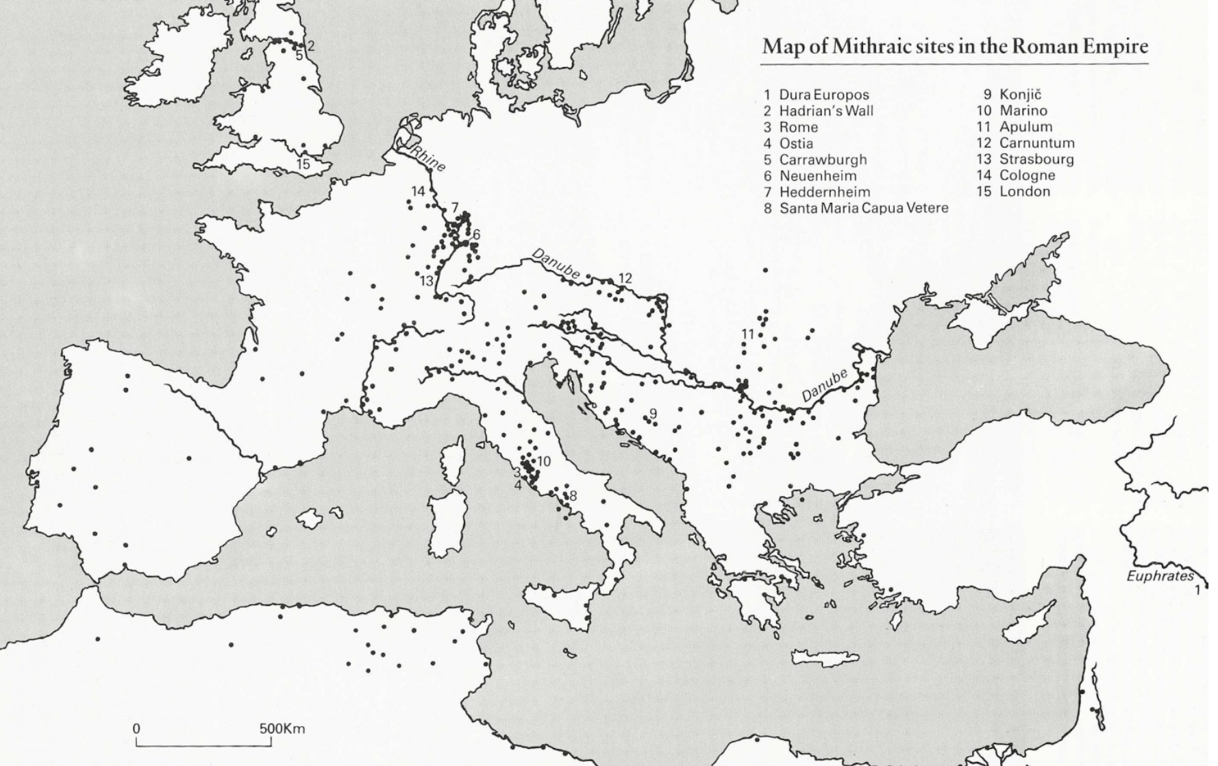

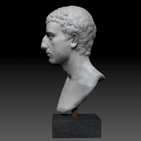


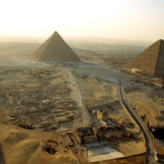
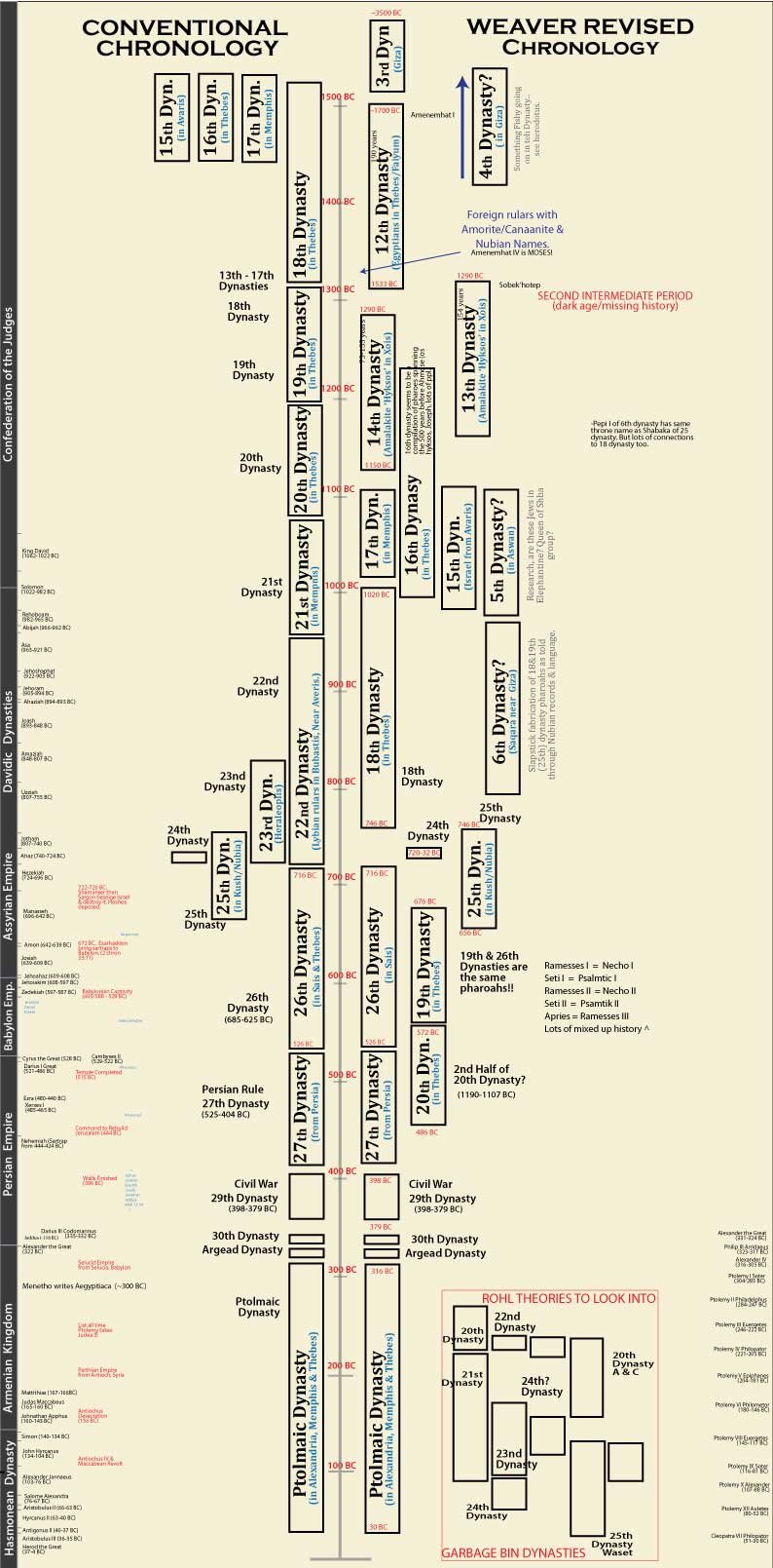
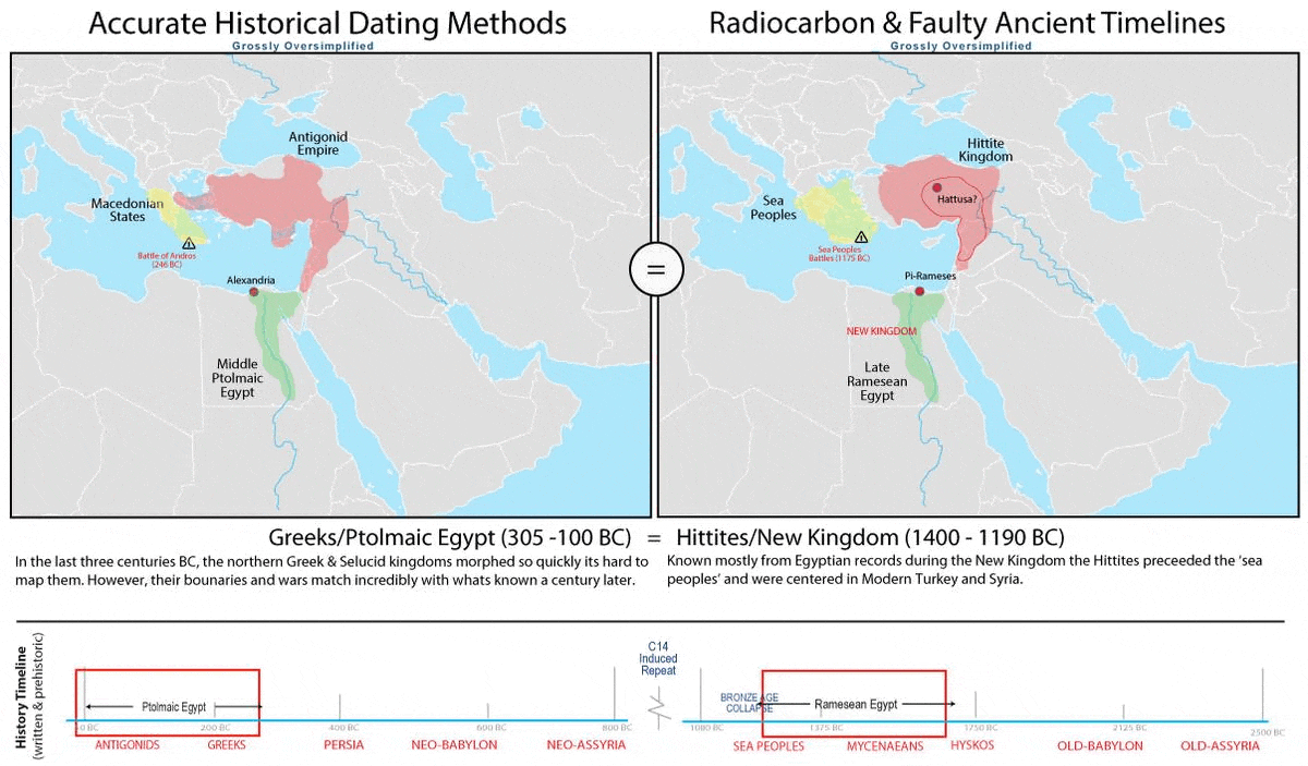
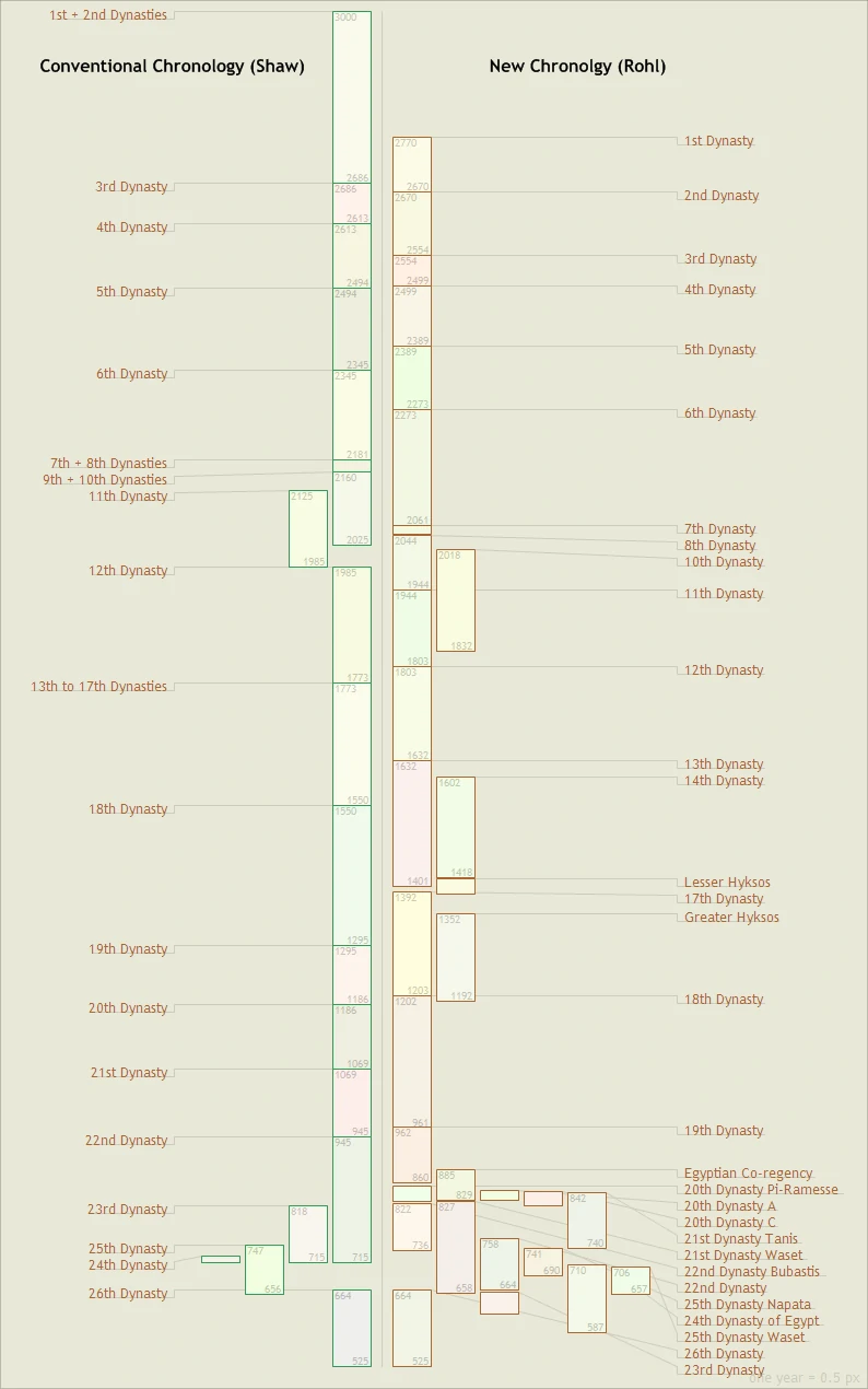


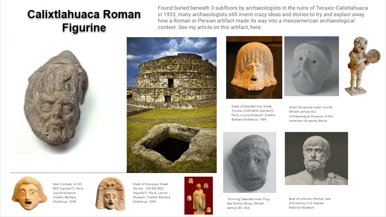


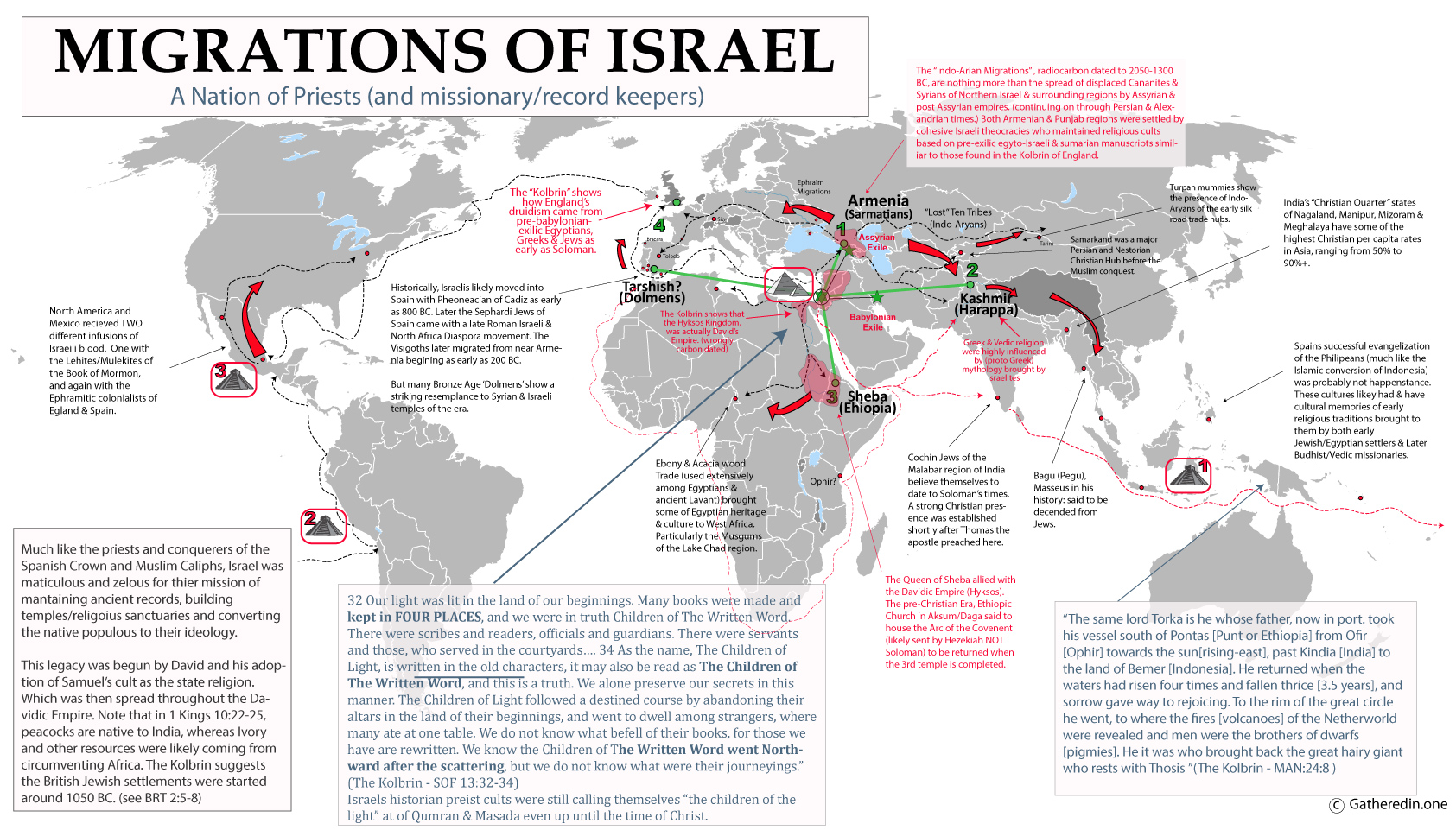


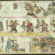
![[View the TL report]](http://www.unm.edu/~rhristov/TLTestReport.jpg)