Distances in the Book of Mormon. Is a Fully Limited Mesoamerican Model Really Reasonable?

Introduction & Outline
Much like Israel in the Bible, one can assume from the short number of days travel stated in the Book of Mormon text that the distances between primary lands in the text such as the Land of Zarahemla and the Land of Nephi are regionally limited. The 21 days journey mentioned in the text between Nephi & Zarahemla for instance, virtually assures an area of between 200 and 500 miles.
However, to suggest as many have that the text never once mentions a region, journey, travel or war exceeding 400 miles seems incredibly unlikely when compared with what is known of ancient pre-Columbian travel & cultures, Old world cultures & travel in the bible or even just common sense of what we know of similiar historic peoples.
Indeed imagine an ignorant translator of the biblical text trying to suggest that the book never gave a single mention of Rome (1500 miles from Israel), or Ethiopia (1200 miles from Israel), or Babylon (700 miles from Israel), or Somolia/Punt ( ~2000 miles from Israel), or India (2000 miles from Israel) or ANY location outside of the immediate bounds of Canaan. And all just because they couldn’t find translations between the ancient names and moder locations. Only because of our knowledge of ancient language do we know that ALL of these regions are actually mentioned in the bible–and many are intricately connected to the history of the tiny nation of Israel. Yet this scenario is what many proponents of the Limited Mesoamerican propose of the Book of Mormon text when they suggest that the Book of Mormon ‘Cumorah‘ or land Northward, or ‘land of many waters, rivers, and fountains‘, existed in Mesoamerica instead of matching these locations to their more intuitive North American counterparts.
In this article we will explore whether a limited Mesoamerican model for the Book of Mormon is really reasonable. Or whether a more expanded model is more reasonable. In order to analyze this we will use the following data points.
- Quick overview of distances in the Book of Mormon text
- War Campaigns and travel in the Bible and Old World.
- Known trade networks among Mesoamerican and North American peoples.
- Clues from early Spanish explorers & Mesoamerican histories (images of Ixtlilxochitl AND the early Spanish explorer images)
- Book of Mormon textual clues to the extent of the Land Northward.
- Archaeological evidence of Final Book of Mormon exodus.
.
Quick overview of distances in the Book of Mormon text
I largely agree with John L. Sorenson’s chapter “Distances & Directions” in Mormon’s Map (for central Book of Mormon lands), which provides a fair analysis of Book of Mormon geography by interpreting textual references to travel times, particularly “days traveled,” to construct a model for central Book of Mormon lands (from the lands of Zarahemla to Nephi) spanning roughly 250-500 miles north-south.
Sorenson, with many other Book of Mormon geographers derives distances by averaging historical data from pre-Columbian Mesoamerica, where foot travel averaged 11-15 miles per day in rugged terrain, adjusting for factors like group composition, warfare, or wilderness obstacles (e.g., Alma’s 21-day exodus yields ~250 miles, implying detours in a straight-line 180-mile path). Complementary sources reinforce this: a hard day’s march often equates to 20-30 miles in open country but less in hills, with “one and a half days” across the narrow pass (Alma 22:32) spanning 10-30 miles east-west. Variations appear, such as quicker military marches (25-40 miles/day), but Sorenson prioritizes civilian paces to fit the narrative’s logistical details, like pursuits under two days covering under 50 miles.
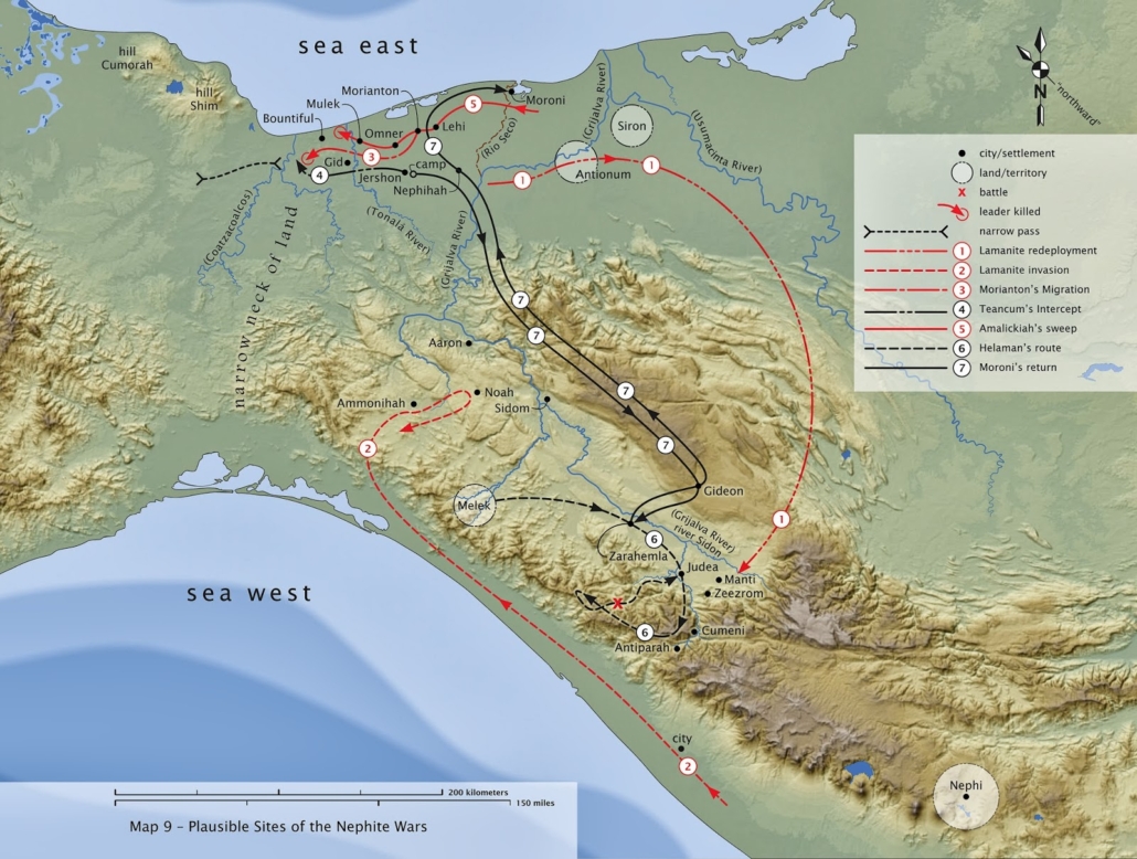
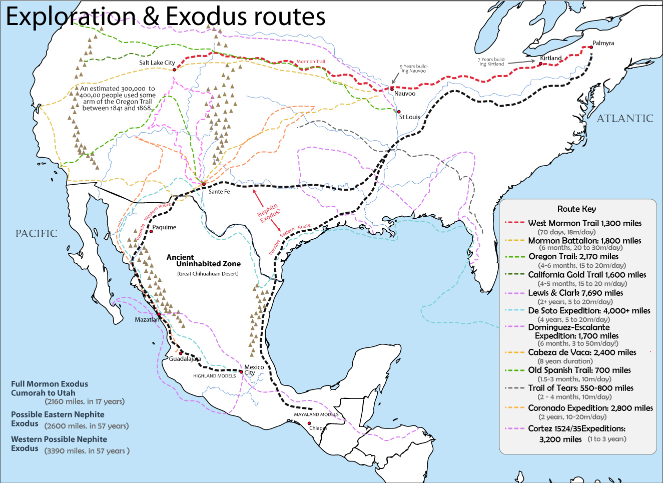
Note however, I differ from Sorenson in the distances of the MULTI-YEAR journeys between the Land Northward and Southward. I also believe the directions in Sorenson’s model, are untenable, as are the size and scope of his sites (such as Zarahemla as Santa Rosa). The Highland model solves all the issues with his model, and below I show the most likely marches, travels and routes for Book of Mormon events in my own model.
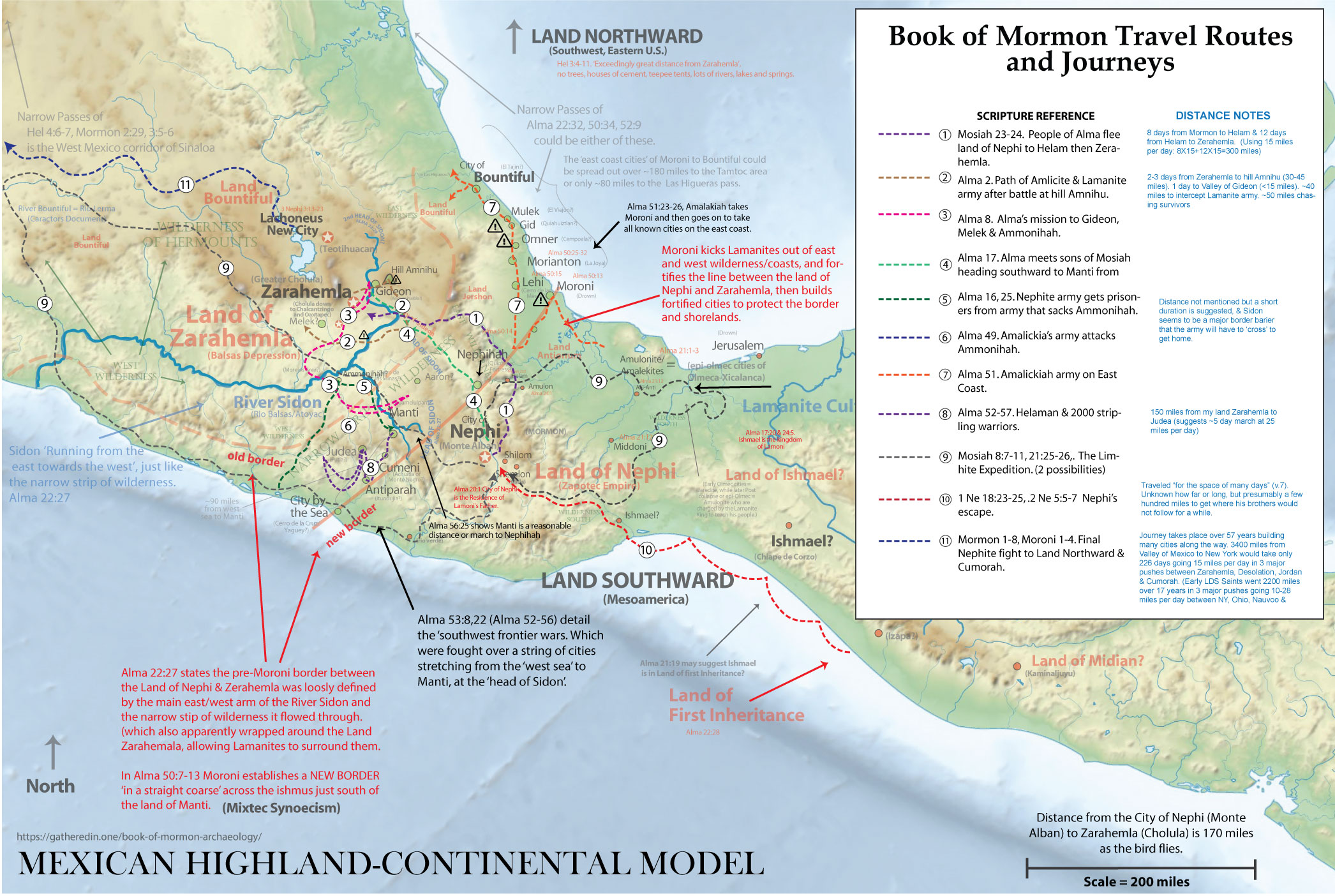
TABLE OF DISTANCE INDICATORS IN THE BOOK OF MORMON
| Reference | From | To | Days travel | Estimated Distance (miles) | Notes |
|---|---|---|---|---|---|
| 1 Nephi 17:4 (ch.1-17) | Jerusalem | Bountiful; Oman | ‘8 years’ | 2,065 miles ! | Known endpoints. Many stops. |
| 1 Nephi 18:23 | Bountiful; Oman | Americas | ‘many days’ | 15k-18,000 miles | By boat, “many days” |
| 2 Nephi 5:7–8 | Land of first inheritance | Land of Nephi | ‘many days’ | unknown | #10. Migration from beach to inland. |
| Mosiah 18:4, 31–34 | City of Nephi | Waters of Mormon (near Nephi) | ~1 day? | 4-8 miles | #1. Distance Inferred by proximity to Nephi |
| Mosiah 18:31–34 Mosiah 22:16; 23:30-31, Mosiah 23:1–4, 19 | City of Nephi/Waters of Mormon | Land of Helam | 8 days | ~80-120 miles | #1. Inferred from total route; |
| Mosiah 24:20–25 | Land of Helam | Zarahemla | 13 days | ~130-195 miles | #1. Part of 21-day total; |
| Mosiah 23:3; 24:25 | Waters of Mormon (near Nephi) | Zarahemla | >21 days (13+8+?) | ~250 (straight: 180) | #1. Families/flocks, detours; |
| Alma 2 (15-19) | Land of Zarahemla | Hill Amnihu (nearby) | 2+ days “all that day” | ~20-30 miles? | #2. Amlicite march; |
| Alma 8:3–6 | Zarahemla | Melek & Ammonihah | 2-3 days | 45+ miles? | #3. Hilly terrain; |
| Alma 17 (1-4,7-9) | Zarahemla | Manti | ‘many days’ | 100+ miles? | #4. Alma/Sons of Mosiah reunion. |
| Alma 16, Alma 25 | Zarahemla | Sidon/Manti | unknown | *? | #5. Nephite retreval of prisoners |
| Alma 49 | Nephi | Ammonihah | unknown | *? | #6. Attack on Ammonihah |
| Alma 51 | Zarahemla | Nephihah to Mulek | unknown | *? | #7. Amalickiah army on East Coast |
| Alma 56 – Alma 57 Alma 56:30–57, Alma 57:1–34 | Southeast coast cities; Judea, Antiparah, Cumeni | Manti & Head of Sidon | Likely similiar to 3 days death run. v.40-42 | *? | #8. Stripling warrior military marches & menuviers; |
| Mosiah 21:25–26, Mosiah 8:7–11 | Land of Nephi | Desolation & Many Waters | ‘many days’ | unknown- 300-5000 miles? | #9. Limhite Exploration Expidition. |
| Alma 22:32 | Line between Bountiful/Desolation (east) | Same line (west) | 1.5 days | 10-20 miles | Narrow pass width; |
| Helaman 4:7 | Fortified line (west sea) | Same line (east sea) | 1 day | 7-15 miles | Southern Bountiful boundary; |
| Hel 3:3–5 (whole ch.) | Zarahemla | Desolation & Many Waters | not stated | ‘Exceedingly Great Distance’** | only reference to such a large distance. |
| Mormon 1-8 | Zarahemla | Cumorah | ’63 years’ ! (321-384 AD) | unknown- ** ~100-3400 miles? | #11. Flight to Cumorah. |
| Ether 9:3 | Moron/Desolation | Ablom (near Cumorah) | ‘many days’ | unknown- ** ~100-2000 miles? | Omer’s flight into exile |
| Ether 14-15 | Moron/Desolation | Hil Ramah/Cumorah | several years | unknown- ** ~100-2000 miles? | Jaredite flight to anhilation at Ramah |
*If the City of Nephi to Zarahemla is about 21 days (13+8+1 or 2), which is likely 210-315 miles using the Colonial Mesoamerican average of 10-15 miles per day, then the distance to these cities known to be (about half way?) between Nephi & Zarahemla are likely on the order of 100 miles.
**Given that the distance between Zarahemla and the Land of Many Waters in the Land Northward is the ONLY distance in the Book of Mormon said to be an EXCEEDINGLY long distance, and takes the final exodus 63 years to migrate to, we can safely assume this is an incredibly long way, likely in the thousands of miles.
.
Warfare and Travel in the Old World as a Book of Mormon Analog
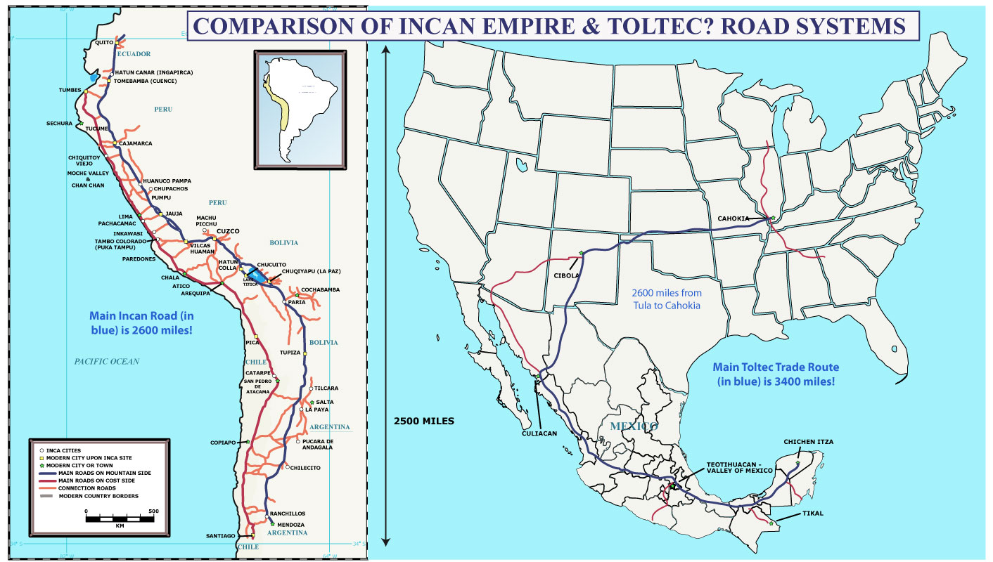
One widely believed, but poorly thought out reason why two-Cumorah, limited Mesoamerican model proponents hold to their view is their false belief that that the logistics of the final exodus of Nephites & Lamanites to the final battle in the land of Cumorah is just too much for ancient New World people’s to accomplish. This view however is rooted in a poor understanding of history combined with a false colonialist mindset toward the sophistication of pre-Columbian peoples.
Indeed histories of Mesoamerican people’s give comparative numbers when talking about battle casualties. Ixtlilxochitl for instance tells of multiple enormous battles with casualties stated in the millions. The possible truth of these numbers should not be surprising when comparing the size and complexity of ancient Mexican Highland ruins like Teotihuacan, Cholula & Tikal with Eurasian analogs — or even the conquest era city of Tenochtitlan. The battle of Tenochtitlan between the Aztec and Cortez with his native allies numbered 200,000 against some 80,000 Aztec. In fact these numbers could be quite analogous to those we might suspect in the final battle, where Mormon numbers his remaining spent force of men, women and children at 230,000 (Mormon 6:7,10–15) against what we’d suppose as a well trained Lamanite army of braves who “filled [the Nephites] with terror because of the greatness of their numbers” (Mormon 6:8). Given the previous numbers offered for the Lamanite forces of 30k and 40k (Mormon 2:9,25), 80k might not be far off. (although as we’ll see in a moment, it could be as little as 10-30k given the analogs we’ll discuss)
(add ixtlitchochitl quote of how they killed everyone to the death)
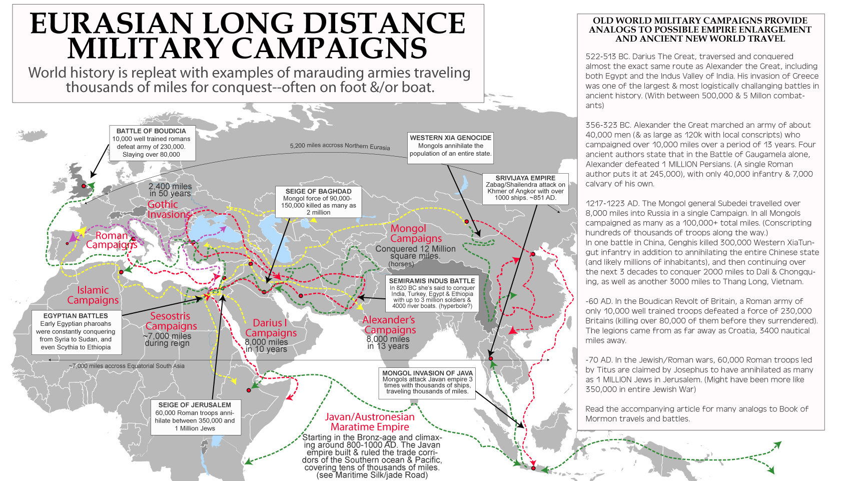
Early Egyptian War Campaigns
As early as 1900 BC, Pharaohs’ like Senusret I & III were leading war campaigns THOUSANDS of miles into Nubia & Russia. Both Herodotus & Diodorus relate how Sesostris (Senusret III) “set out with ships of war from the Arabian gulf (Red Sea) and subdued those who dwelt by the shores of the Erythraian Sea (Gulf of Aden), until as he sailed he came to a sea which could no further be navigated by reason of shoals.” He then returned and “took a great army and marched over the continent, subduing every nation… traversing the continent, until at last he passed over to Europe from Asia and subdued the Scythians and also the Thracians” during which he colonizes the farthest reaches of the Black Sea to the River Phasis in Colchis or modern Russia/Georgia/Armenia (Histories, Book 2, 102-108).
Herodotus also relates how Senusret was one of the only pharaohs to subdue all the Ethiopians, and we can assume from the sea campaign mentioned above that he attacked not only from the Nile, but from the coasts of Somalia, some 2000 miles from Egypt. Likewise, we are told he was the first prior to Darius to subdue the Scythians (Steppe peoples of Georgia/Russia), again some 2000 nautical miles from Egypt! He says of those he conquered that he, “employed the multitude which he had brought in of those whose lands he had subdued, as follows—these were they who drew the stones which in the reign of this king were brought to the temple of Hephaistos, being of very great size; and also these were compelled to dig all the channels which now are in Egypt.” (Histories, Book 2, 102-108).
Alexander The Great
Perhaps the most famous long-distance overland conqueror was Alexander the Great. He marched an army of about 40,000 men (with as large as 120k with local conscripts) on campaigns totaling as much as 22,000 miles over a period of 12 years. Four ancient authors state that in the Battle of Gaugamela alone, Alexander defeated 1 MILLION Persians. (A single Roman author puts it at 245,000), with only 40,000 infantry & 7,000 cavalry of his own. Alexander is spoken of in many ancient texts, but many don’t realize that the core of his army was quite small and included mostly infantry. Many also don’t realize that Alexander simply mimicked the exploits of Darius the Great who lived two centuries earlier.
Darius The Great
Although less, famous, but perhaps a much better analog to Book of Mormon Darius conquered much of the known world between 522 & 513 BC. Darius the Great of the Persian (Achaemenid) Empire traversed and conquered almost the exact same route as Alexander the Great, including both Egypt and the Indus Valley of India. He led campaigns from Ecbatana Iran, 1200 miles to Egypt, 2600 miles back and over to the Indus Valley and then back and around the north side of the Black sea in a Scythian campaign of over 4000 miles. Herodotus puts his elite infantry of “immortals” foot solders at 10,000 men, with up to 80,000 conscripts in certain campaigns.
Darius’ successor Xerxes I assembled one of the largest ancient forces ever for his invasion of Greece. Herodotus placed the Persian combined forces at 5,283,220, Simonides said 4 million and Ctesias gives 800,000 troops –although modern estimates suggest between 300,000 & 500,000. The logistics of transporting such a huge force and their supplies from Iran & Turkey, across rivers and the Dardanelles or ‘Hellespont’ straights and into Greece was detailed by several ancient authors and may serve as the best source material for exploring the possible reality or hyperbole involved in the story of Nephite final destruction. In a single year, using 600-1200 ships for support & supplies, Xerxes army started in his capital of Persepolis Iran, likely starting with a small elite force of generals and gaining numbers as it went. To reach the Dardanelles (Constantinople) would have been 2000 miles! (With at least 2 stretches of over 150 miles not accessible by boat). Herodotus tells us that most his troops came from central Turkey, and begins the detailed portion of his account at the Dardanelles. He also gives us a time estimate for the section from Hellespont/Dardanelles to Therme of taking about 3 months to travel the 360 miles, so we can assume that the larger the army grew, the slower the progress. Read about the entire campaign on wikipedia here.
The Boudican Revolt
In the Boudican Revolt of 60 AD in Britain, a Roman army of only 10,000 well trained troops defeated a force of 230,000 Britains (killing over 80,000 of them before they surrendered). The legions came from as far away as Croatia, 3,400 nautical miles away. This is a great example of how a well trained army can dominate against a peasant army of men women and children. Much like the Book of Mormon final battle with suggests a number of 230,000 men, women and children against an unknown host of Lamanites.
Similarly, in the Jewish/Roman wars of 70 AD, 60,000 Roman troops led by Titus are claimed by Josephus to have annihilated as many as 1 MILLION Jews in Jerusalem. (Might have been more like 350,000 in entire Jewish War according to modern estimates–which have trouble believing the numbers of ancient historians).
The Mongol Siege of Bagdad & Western Xia Massacre
The Mongol general Subedei travelled over 8,000 miles into Russia in a single Campaign. In all Mongols campaigned as many as a 100,000+ total miles. (Conscripting hundreds of thousands of troops along the way.)
In one battle in China, Genghis killed 300,000 Western Xia Tungut infantry in addition to annihilating the entire Chinese state (and likely millions of inhabitants), and then continuing over the next 3 decades to conquer 2000 miles to Dali & Chongquing, as well as another 3000 miles to Thang Long, Vietnam.
The Mongol siege of Bagdad could be a somewhat analogous historical account of a massacre the size of that mentioned in the Book of Mormon. In that campaign, the Mongols led by Hulagu Khan expanded their territory first 3,000 miles from Mongolia into Azerbaijan where they set up new northern Persian capitals from which to attack Mesopotamia. This would be somewhat similar to what I’ve proposed with the Lamanites setting up a base in the Southwest or Midwest after conquering the Land of Jordan. The 13th century Ilkhanate then marched 500 miles onto Bagdad with a force of 40,000 Mongol Calvary, 40,000 Armenian infantry and 10,000-50,000 Persian & Georgian infantry conscripts. The siege lasted only 13 days with the Mongols largely depopulating the city massacring between 90,000 and 2 million men woman and children.
General Belisarius
Just a few hundred years after the date given in the Book of Momon for its final battle, Justinian’s general Belisarius led campaigns from Constantinople to 1400 nautical miles to Carthage, reconquering both North Africa, Italy and Southern Spain. In his north African campaign he took a force of 5,000 calvary, 10,000 infantry, 500 transport ships and 92 warships crewed by 30,000 sailors. With this elite force he defeated a similar sized army and took control of Carthage with a regional population of well over a million.
The ‘Long March’ by the Chinese Communists was a force of 100,000 who traveled by foot over 6,000 miles over 368 days is one of the logest of this century.
–
Evidence of Early Spanish Explorers Traveling Long Distances
–
Evidence of Continental Trade in the New World
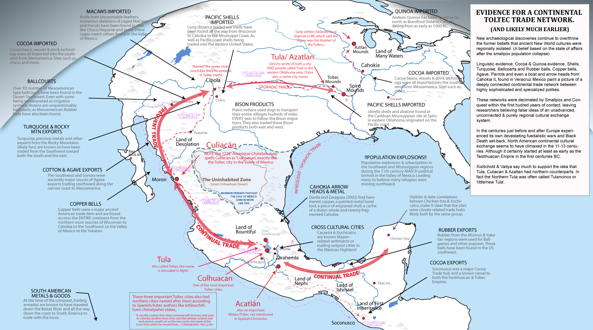
- Imported cacao grown in the Mayanlands is being found all over the southwest & possibly even eastern US. (Gamblers, Washburn 2011, @Cahokia, Mark Nickless, Crown, 2012)
- Southwest Turquoise was traded south in exchange (Washburn 2011)
- Imported macaws in the southwest were evidence of strong cultural ties to Mesoamerica. (Powell 2015, Messer 2018, Wyckoff 2015, Watson 2015)
- Mesoamerican style ballcourts in the southwest were evidence of strong cultural ties to Mesoamerica. (Overview, Crispin 2020, Whalen 2017, Pauketat 2022)
- Pyrite mirrros, copper bells and other Mesoamerican artifacts in the southwest (AMNH article, Boyce 2015)
- Beads & shells found in Spiro Mounds originated on the Pacific Coast. (Kozach 2002, Sanderson, Earkens 2005)
- Cabrera Davila and Diana Zaragoza’s excavations at Tamtoc in the 1990s unearthed a fragment of a sheet of hammered copper, a pointed metal hand tool, a piece of engraved shell, a cache of a dozen whole and twenty fragmented Cahokia projectile points (Gidwitz, White, 2017, Davila 1997).
- Artwork and pottery in Spiro Mounds & Etawah have ties to the west coast & possibly Mexico. (white 2008, summary)
- Synthesis of likely continental trade evidence. (Lekson, White)
Increasing evidence is showing the interconnected nature of ancient Mesoamerican empires with North American trade hubs. Cacao/Chocolate, turquoise, ballcourts, and quinoa being some of the best evidence forcing modern archaeologists to radically reshape their long held views of limited North American interaction. Particularly, the areas in the SW are being seen for the large trading centers they were—connecting a big part of the continent in a pansouthwest trade network. It stretched to the Pacific in southern California, to the Gulf of California, north to the mobile Plains people and the sedentary plains people like the Mandan and Pawnee, east to the Gulf of Mexico, and far south to Aztec lands. Some of the items traded were: domestic turkeys, corn (maize), squash and beans, copper bells, pottery, shells of many sorts, obsidian, parrots and feathers, cotton textiles, tallow, buffalo meat, malchite, pedernal chert, lead, sillimanite, leather goods, and much more were traded.
Shells from the Pacific have been found in Mississippian mound building culture sites. Some olivella shells and abalone found at the Caddoan Mississippian site at Spiro in eastern Oklahoma originated on the Pacific coast. These would have had to have been brought by trails from the Pacific to Zuni, to Taos and then to people that brought them to Spiro. Spiro was a major western outpost of Mississippian culture, which dominated the Mississippi Valley and its tributaries for centuries. Because they were in contact with people who knew about the Aztecs it is likely they know about them too.
Here is a diagram/map of routes that pacific shells were carried by people form one culture area to the next in the SW and Southern California. All these areas were in turn connected to Aztec areas to the south and to peoples on the Plains and Mississippian peoples.

The evidence of chocolate in vessels as far north in Pueblo cultures as Utah and Colorado shows it was regularly consumed. But it was not just the cocoa beans that were traded. The way to make them into a drink was also learned and the shapes of special pottery vessels to prepare that drink was brought from the south to the American SW. Culture, technology, and information moved north. With that information would have come knowledge of large cities to the south.
Because the closest place Chocolate can be grow is south of the Aztec capital and all trade went through there, it is all but certain they knew about the Aztecs. It is possible that they traded with people on the Pacific coast but those people were in close contact with the Aztec. Turquoise that can be chemically traced from the SW is found in Maya areas.

It’s important to remember what kind of scale the Aztec civilization was. It is also important to remember that today’s borders are random and meaningless in a historical sense. Because people were trading with the Aztecs, it is to me simply ludicrous to imagine they did not know about the Aztecs. It was definitely something people would talk about.
The main center of the Aztec empire, that controlled both the empire and managed tributary states, was a city on an island with causeways on a lake. The main market had about 20,000 people in it on regular days and 40,000 of festivals. Cortez estimated 60,000. There were 45 major public buildings. Some of the temples were 200 feet high and 262 by 328 feet at the base. The palace had 100 rooms. The most common estimate is that 212,500 people were living there on 5.2 sq mi. The Empire was multi-ethnic, multi-lingual realm stretched for more than 80,000 square miles through many parts of what is now central and southern Mexico. At least 15 million people lived in it. They lived in thirty-eight provinces. Below are a few more points of evidence.
- The remains of women & children in an ancient collapsed azurite mine shaft in Utah may give support to the concept of the Southwest & Rockies as natural resource export hubs (Coulam 2023, Kuban, 2002, UT Archeology 1995)
- Andean Quinoa, has been found as far north as Brantford Ontario dating to 1000 BC. (Daley 2019, Science 2019)
- Pottery showing up in the Carolinas before Mesoamerica, may suggest transatlantic travel. (Hoopes)
- The Solutrean hypothesis suggest very early transatlantic trade (Wikipedia)
Linguistic & Historical Evidence
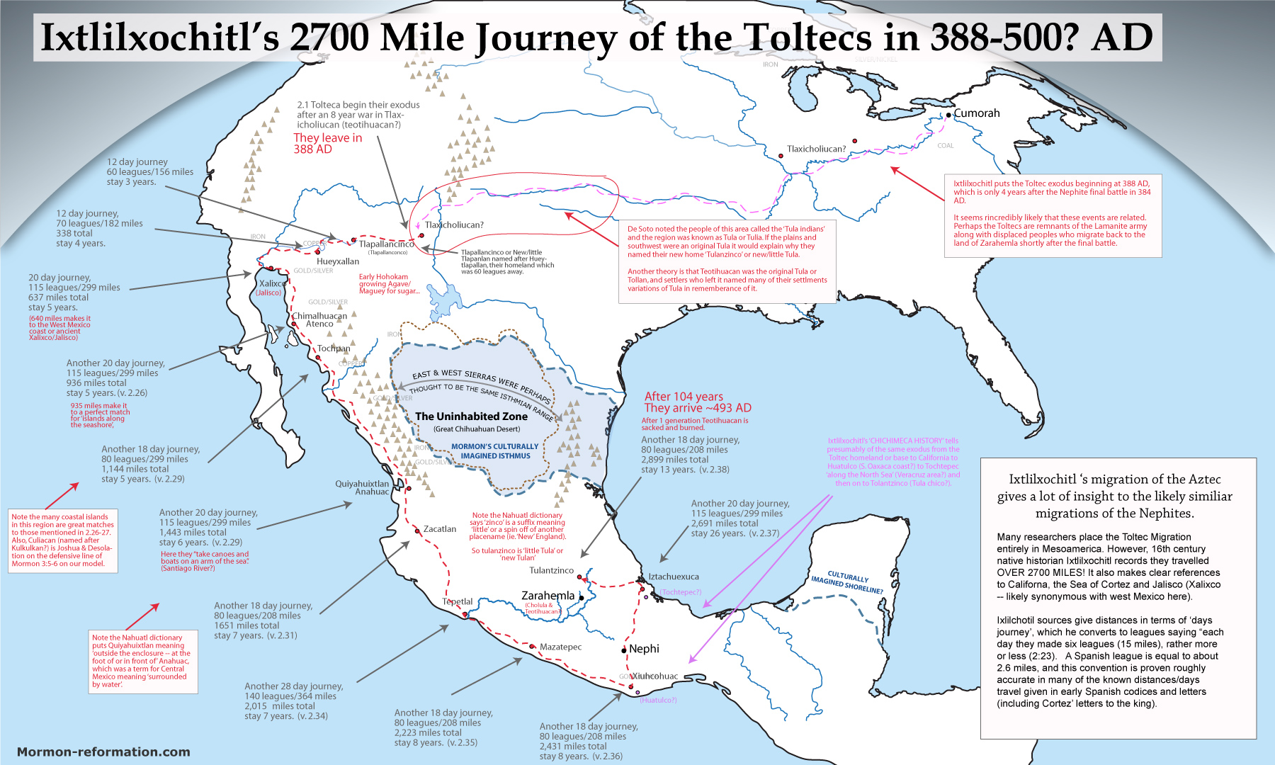
In addition to the archaeological evidence mentioned above, we have historical evidence recorded by early Aztec/Spanish Codices and oral histories telling of the migration of peoples between the the US southeast, southwest and the Valley of Mexico. Although considerable debate exists on where exactly the fabled homeland of the Toltecs & Chichimecs of the annals came from there are numerous indicators (often dismissed by historians) suggesting a location in the Southwest or Midwest of present United States.
he first chapter of Duran’s ‘history of the Indies of New Spain’ matches what is said by Ixtlilxochitl’s summaries of the flood and tower of babel, and exodus with ‘things raining down’. he says
“I have obtained from my Indian informants tells of the seven caves where their ancestors dwelt for so long and which they abandoned in order to seek this land, some coming first and others later until these caves were totally deserted. The caves are in Teocolhuacan, which is also called Aztlan, “land of Herons”, which we are told is found toward the north and near the region of La Florida.”
–
Textual Evidence from the Book of Mormon Itself
Limited Mesoamerican Models require a “two Cumorah theory” (Mormon 6:2: vs D&C 128:20), where Moroni sneaks about alone trying not to be discovered (Mormon 8:3–5, Moroni 1:1–3) with the heavy plates over 1,900 miles after the final battle which they suggest happened somewhere in southern Veracruz Mexico to get to New York to bury the plates. While suggesting that Cumorah and the final battle are ONLY around 100 miles from the ‘Narrow Neck’, which requires the readers to believe that Mormon for some confusing reason, took all the records from the Hill Shim in desolation (when the Lamanites looked to ‘overthrow the land’- Mormon 4:23), only to transport them to a new random hill only 100 miles away. One which had very little strategic or geographic advantage, where they still exist to this day–completely separate from the region in upstate New York where the Book of Mormon would be buried for Joseph Smith. Think about this–-when the early LDS saints fled from Ohio and Nauvoo; 30,000-70,000 people fled over 1,500 miles to find safety and a new home. In fact they traveled over 2100 miles over 17 years building several cities between New York & Utah. So why would 300,000 Nephites, flee only 100-250 miles building no traceable cities over a 50+ year period? Especially when a flight up the Caribbean coast toward Texas would have been so easy?!
The text gives no indication they were being hedged in from the north by some other group, and SURELY would say if a force larger than their 300,000 were hemming them in! Besides, with their massive army ready to make a stand or die, they surely would have attempted to cut their way through the Huestec lands in search for a northern land to settle. A last stand of such a huge group consisting of men, women and children really only makes sense if they were forced SO far north (ie. New York) that they reached the edge of the habitable continent and had nowhere left to flee because of Great Lakes (Ripliancum) and coming winter. And since this is where the plates were found AND where prophetic visions put the last battle, WHY ON EARTH would anyone try and conceive a second Cumorah in Mexico only a few hundred miles from Zarahemla?! This illogical proposal has effectively split the church and given birth to the even poorer heartland models. Those who believe and push this theory, do a great injustice to Book of Mormon geographic correlation.
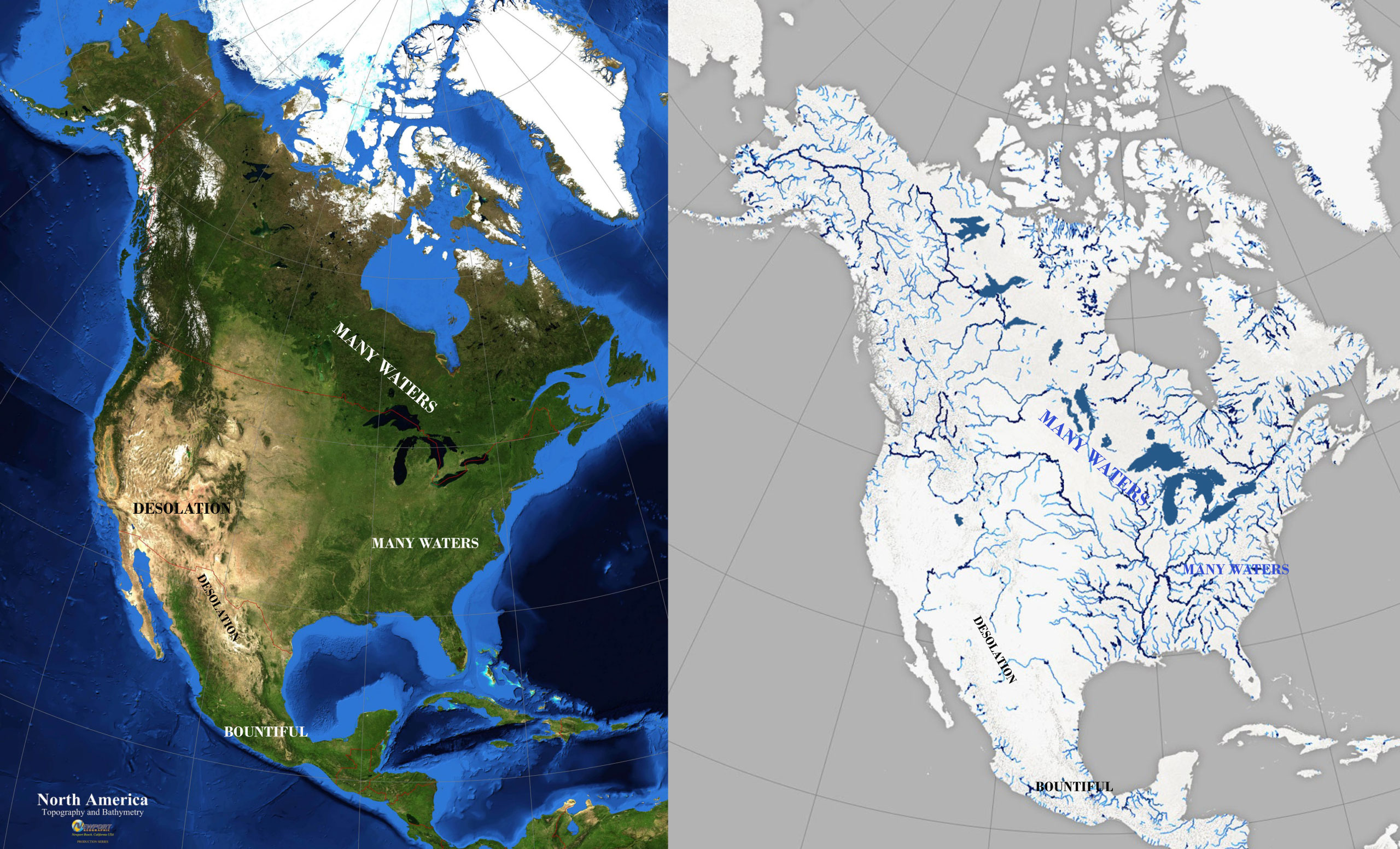
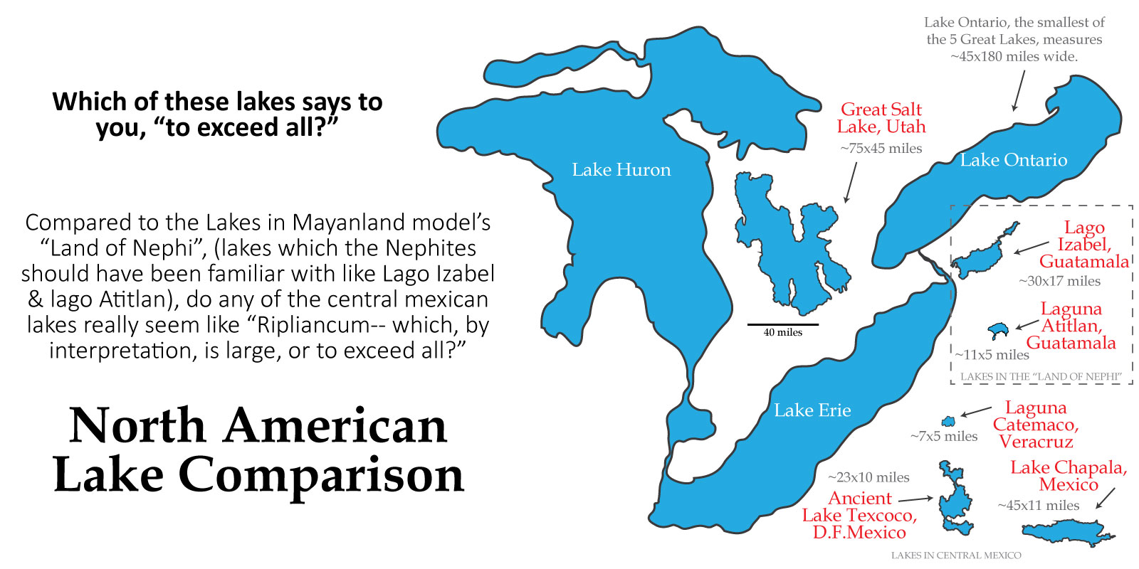
– LAND OF MANY WATERS OR LARGE BODIES OR ‘LARGE BODIES OF WATER AND MANY RIVERS IS OBVIOUSLY NORTHERN-MOST NORTH AMERICA (EASTERN US & CANADA). It stretches one’s imagination to the limits to suggest that the following four verses in the Book of Mormon are referring somewhere like the Valley of Mexico or Vera Cruz. The text says these locations are “an exceedingly great distance” from Zarahemla, and contained “many waters” and “many rivers” and “many large bodies of water”. To cultures familiar with Lake Izabal and Lago de Ititlan in Guatemala or the Grijalva & Usumacinta river systems in Mexico to refer to the Lakes of the Mexican Highland such as Texcoco or Chapala in following manner is almost laughable when contrasted with the clearly obvious region around Joseph Smith’s ‘Cumorah’ of the Great Lakes or Rivers and springs of the Canadian shield or Upper Mississippi River systems.
3 And… there were an exceedingly great many who departed out of the land of Zarahemla, and went forth unto the land northward to inherit the land. 4 And they did travel to an exceedingly great distance, insomuch that they came to large bodies of water and many rivers. 5 Yea, and even they did spread forth into all parts of the land, (Hel 3:3–5)
29 Therefore, Morianton put it into their hearts that they should flee to the land which was northward, which was covered with large bodies of water, and take possession of the land which was northward. (Alma 50:29)
8 And they were lost in the wilderness for the space of many days, yet they were diligent, and found not the land of Zarahemla but returned to this land, having traveled in a land among many waters, having discovered a land which was… covered with ruins of buildings of every kind, having discovered a land which had been peopled with a people who were as numerous as the hosts of Israel. (Mosiah 8:8)
4 And it came to pass that we did march forth to the land of Cumorah, and we did pitch our tents around about the hill Cumorah; and it was in a land of many waters, rivers, and fountains (Mormon 6:4)
Below is a comparison of Guatamala’s Lago Izabel, in the Mayanland model’s Land of Nephi, compared to the Lakes of Coastal Veracruz and the Mexican Highland & Great Salt Lake and then the Great Lakes. As you can see, there’s not much
– TIMBER BEING SCARSE IN THE LAND DESOLATION IS PROBLEMATIC. The land of Desolation is said to be desolate because of the Jaredites who were destroyed AND desolate “save it was for timber” or in other words it was desolate or devoid of timber so that the people who live in it had to “live in tents” and become expert in making “houses of cement”. Mayanland models must make the same case as Heartlanders in suggesting that regions which abound in wood and timber must have been “deforested” by the Jaredites in a manner that still left them without timber HUNDREDS of years later. This seems unlikely both in Heartlands Canada and Michigan Peninsula, as well as in Mayanlands south-central Mexico. More importantly, the use of cement in Oaxaca or the Mexican Highland was no more prevalent than its use in mayanlands making the following statement a bit problematic.
6 And now no part of the land was desolate, save it were for timber; but because of the greatness of the destruction of the people who had before inhabited the land it was called desolate. 7 And there being but little timber upon the face of the land, nevertheless the people who went forth became exceedingly expert in the working of cement; therefore they did build houses of cement, in the which they did dwell. 8 And it came to pass that they did multiply and spread, and did go forth from the land southward to the land northward, and did spread insomuch that they began to cover the face of the whole earth, from the sea south to the sea north, from the sea west to the sea east. 9 And the people who were in the land northward did dwell in tents, and in houses of cement, and they did suffer whatsoever tree should spring up upon the face of the land that it should grow up, that in time they might have timber to build their houses, yea, their cities, and their temples, and their synagogues, and their sanctuaries, and all manner of their buildings. 10 And it came to pass as timber was exceedingly scarce in the land northward, they did send forth much by the way of shipping. (Hel 3:6–11)
Both the Mayan and Mexican Highland cultures really ONLY built their temples and city centers of stone. With few exceptions, their homes were primarily wood. Really only the Desert Southwest was desolate of timber to the point of mostly using teepees, wikiups or stone and cement (adobe) for ALL aspects of cultural building. And really only the US Plains Indians could be said to have culturally lived predominately in ‘tents’ or teepees.
.
.
