
Comparing Book of Mormon Geography Models
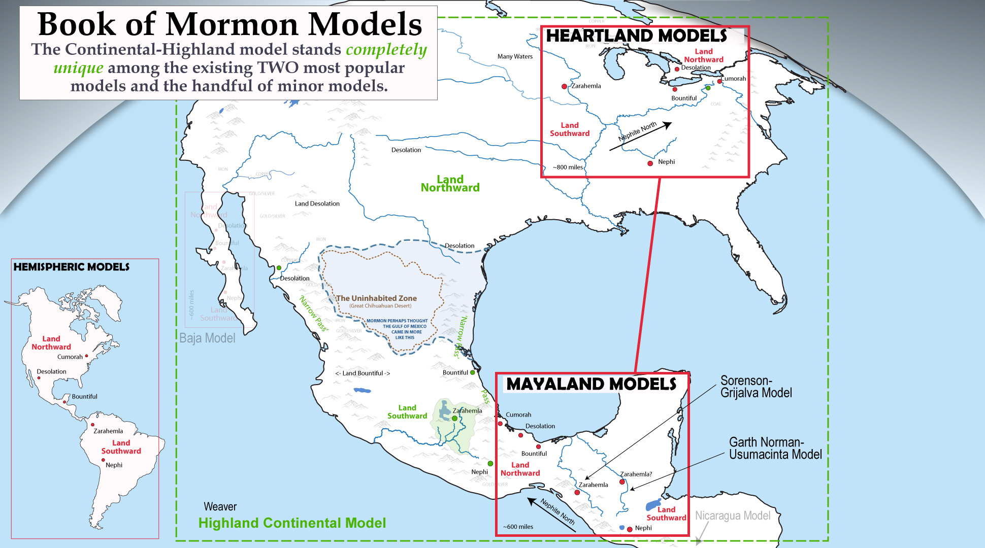
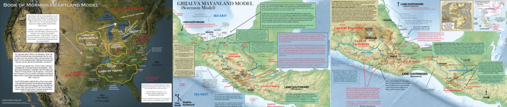
TABLE OF CONTENTS/LINKS
Issues with most models
The heartland model
Limited Mesoamerican models
2 Cumorah theory
The Sorenson/Grijalva models
The Usumacinta models
The Mexican Highland model
Introduction
Among Book of Mormon enthusiasts, there are two primary camps of belief concerning where the events in the book took place. One camp, called the Heartland group, believes the Book of Mormon took place in the ‘heartland’ or center of the eastern United States. This group uses archaeological evidence of ancient Hopewell, Adena and middle woodland cultures to support their model’s claims. A second, more academic group of Book of Mormon enthusiasts believe the Book of Mormon took place entirely in the Mesoamerican area of Southern Mexico and Northern Guatemala. This groups correlates Mayan ruins in Chiapas and Veracruz with Book of Mormon events. GatheredinOne, however is dedicated to a third model loosely proposed by Joseph Smith (you can read ALL his quotes on the matter here) and expanded by this author, called the Mexican Highland-Continental model—where BOTH the United States and Mexico are primary regions of Book of Mormon lands.
Joseph’s ‘Continental Model‘ was never fully developed and quickly lost support even among the earliest Book of Mormon researchers because none could reconcile the idea he seemed to suggest that Mesoamerica was the Nephite Land Southward, while the US Southwest and Midwest were the Nephite land of Desolation—that according to the text, should be directly north of the Book of Mormon’s “narrow neck of land” (which the book seems to paint as an isthmus). This “narrow neck problem“, divided the church and gave rise to a third camp led by Orson Pratt suggesting a Hemispheric model which included North AND South America with Panama as the narrow neck. The current author, however believes to have solved the narrow neck problem by correlating the Book of Mormon’s narrow neck with the Baja California peninsula. In this model, the narrow neck was merely the defining feature used by the ancients (and later Aztec Chroniclers to delineate the border between the Book of Mormon’s Land Southward (Mexico) and the Land Northward (the United States). In another article I show that in the Book of Mormon nothing ever happens ON the narrow neck, only BY the Narrow Neck. And the ‘narrow passes’ of the Book of Mormon although located in the same latitude between the Land Northward and the Land Southward, and providing the same function as a geographic barrier, actually have nothing to do with the Narrow Neck.
Issues with Most Book of Mormon Geographic Correlations
The Book of Mormon’s internal geographic model is incredibly detailed and consistent. Perhaps as much so as any ancient record of its genre. But no Book of Mormon model is without substantial problems when it comes to fitting the geographic descriptions of the text with real world analogs. This article attempts to critique a few of the most popular models with the text.
Although Mesoamerican models generally do a better job at matching the geography of the text than heartland models, still the most difficult geographic feature to reconcile is the detailed configuration of Nephite/Lamanite ‘border’ cities explained the the war chapters of Alma 42-54. In Alma 50:7–14 we learn that Moroni creates a NEW border between the Nephite and Lamanite lands, and fortifies it with garrisons/cities which run between the Land of Nephi and Land of Zarahemla “in a straight course from the east sea to the west [sea]” (Alma 50:8–11, esp. verse 11; Alma 22:27). Alma 56:25 (see also Alma 59:5–7, Alma 43:22) verifies this by showing that south frontier town of Manti, while only a few days march from the west sea city and other south frontier garrisons (Alma 52:12,15; Alma 56:31), is also close enough to reasonably march to Nephihah and Moroni and the east sea (Alma 51:26). Moroni also fortifies the entire east coast from the new southern border all the way to the “Narrow Pass” (Alma 50:34; Alma 52:9) which leads to the land Northward. In essence making a backward L of defensive cities to guard the Nephite southern frontier and eastern coast.
When Amalickiah comes to battle the Nephites in Alma 51, he first takes the southmost ‘east coast’ city of Moroni and “all of their fortifications”, and then goes on to “take Nephihah, Lehi, Morianton, Omner, Gid and Mulek, all of which were east on the borders of the seashore” (Alma 51:26), suggesting that those cities were arranged in that order from south to north along the east sea. They then “march forth… that they might take possession of the land Bountiful and also the land northward” (Alma 51:30).
As we’ll discuss later in this article, this configuration in the heartland model is virtually impossible unless you tuck the entirely of the lands of Nephi and Zarahemla in some little corner between the Great Lakes (such as the lower Peninsula of Michigan). However if you do this, you destroyed nearly every other correlative piece of evidence used by Heartlanders. From Zelph, to the D&C Zarahemla, to the Adena and Hopewell ruins.
For the Mesoamerican Mayanland models a similar problem arises when matching the narrow neck with Tehuantepec. The problem lies in the Yucatan Peninsula ruining the logic and description of the ‘east sea cites’ of Moroni, Aaron, Nephihah, Jershon, Lehi, Morianton, Omner, Gid, and Mulek and their proximity to the land and city of Manti at the head of the river Sidon (Alma 50:34; Alma 52:9 — see the section entitled ‘MANTI IS IN PROXIMITY TO NEPHIHAH & MORONI IN THE TEXT’ for details)
This is why essentially NO popular internal model out there seems to look like the Yucatan. They almost universally agree with a ‘backwards L’ configuration of the Alma 42-54 war border cities.
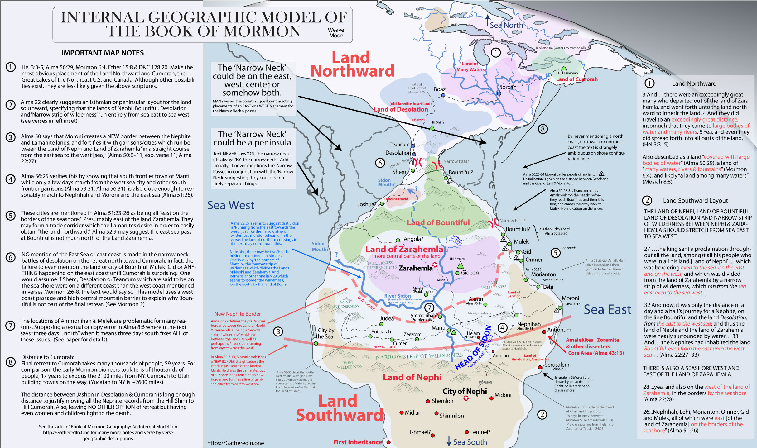
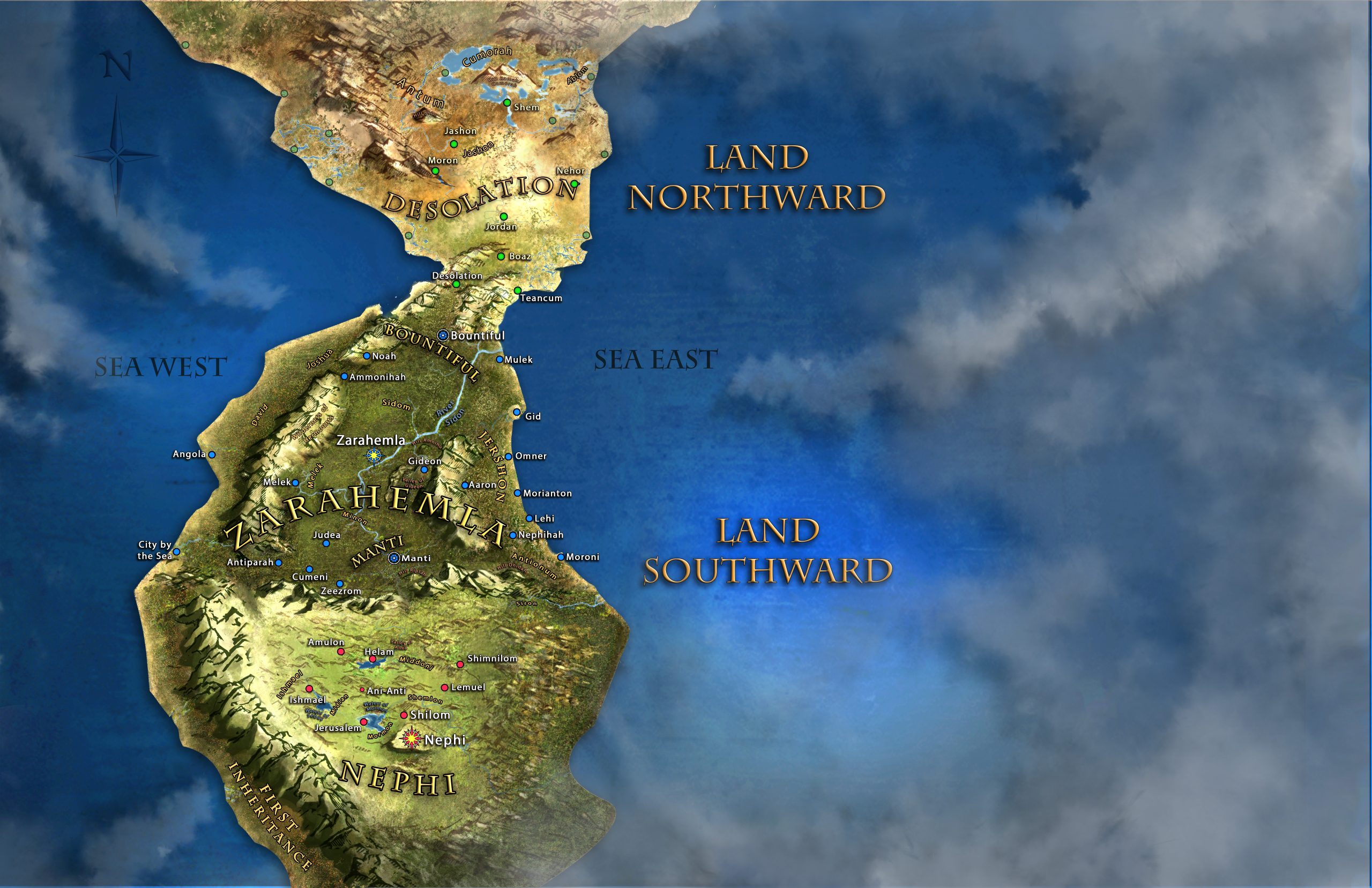
Internal models of The Book of Mormon show a high degree of agreement for a reason. Alma 22 draws a fairly clear picture of the basic layout of Book of Mormon lands.
27 And it came to pass that the king sent a proclamation throughout all the land, amongst all his people who were in all his land, who were in all the regions round about, which was bordering even to the sea, on the east and on the west, and which was divided from the land of Zarahemla by a narrow strip of wilderness, which ran from the sea east even to the sea west, and round about on the borders of the seashore, and the borders of the wilderness which was on the north by the land of Zarahemla, through the borders of Manti, by the head of the river Sidon, running from the east towards the west—and thus were the Lamanites and the Nephites divided.
28 Now, the more idle part of the Lamanites lived in the wilderness, and dwelt in tents; and they were spread through the wilderness on the west, in the land of Nephi; yea, and also on the west of the land of Zarahemla, in the borders by the seashore, and on the west in the land of Nephi, in the place of their fathers’ first inheritance, and thus bordering along by the seashore.
29 And also there were many Lamanites on the east by the seashore, whither the Nephites had driven them. And thus the Nephites were nearly surrounded by the Lamanites; nevertheless the Nephites had taken possession of all the northern parts of the land bordering on the wilderness, at the head of the river Sidon, from the east to the west, round about on the wilderness side; on the north, even until they came to the land which they called Bountiful.
30 And it bordered upon the land which they called Desolation, it being so far northward that it came into the land which had been peopled and been destroyed, of whose bones we have spoken, which was discovered by the people of Zarahemla, it being the place of their first landing.
31 And they came from there up into the south wilderness. Thus the land on the northward was called Desolation, and the land on the southward was called Bountiful, it being the wilderness which is filled with all manner of wild animals of every kind, a part of which had come from the land northward for food.
32 And now, it was only the distance of a day and a half’s journey for a Nephite, on the line Bountiful and the land Desolation, from the east to the west sea; and thus the land of Nephi and the land of Zarahemla were nearly surrounded by water, there being a small neck of land between the land northward and the land southward.
33 And it came to pass that the Nephites had inhabited the land Bountiful, even from the east unto the west sea, and thus the Nephites in their wisdom, with their guards and their armies, had hemmed in the Lamanites on the south, that thereby they should have no more possession on the north, that they might not overrun the land northward.
To explore the details of the above configuration with an accompanying internal model map, see the Internal Model of the Book of Mormon page.
Critique of the Griffin Virtualscriptures.org Model
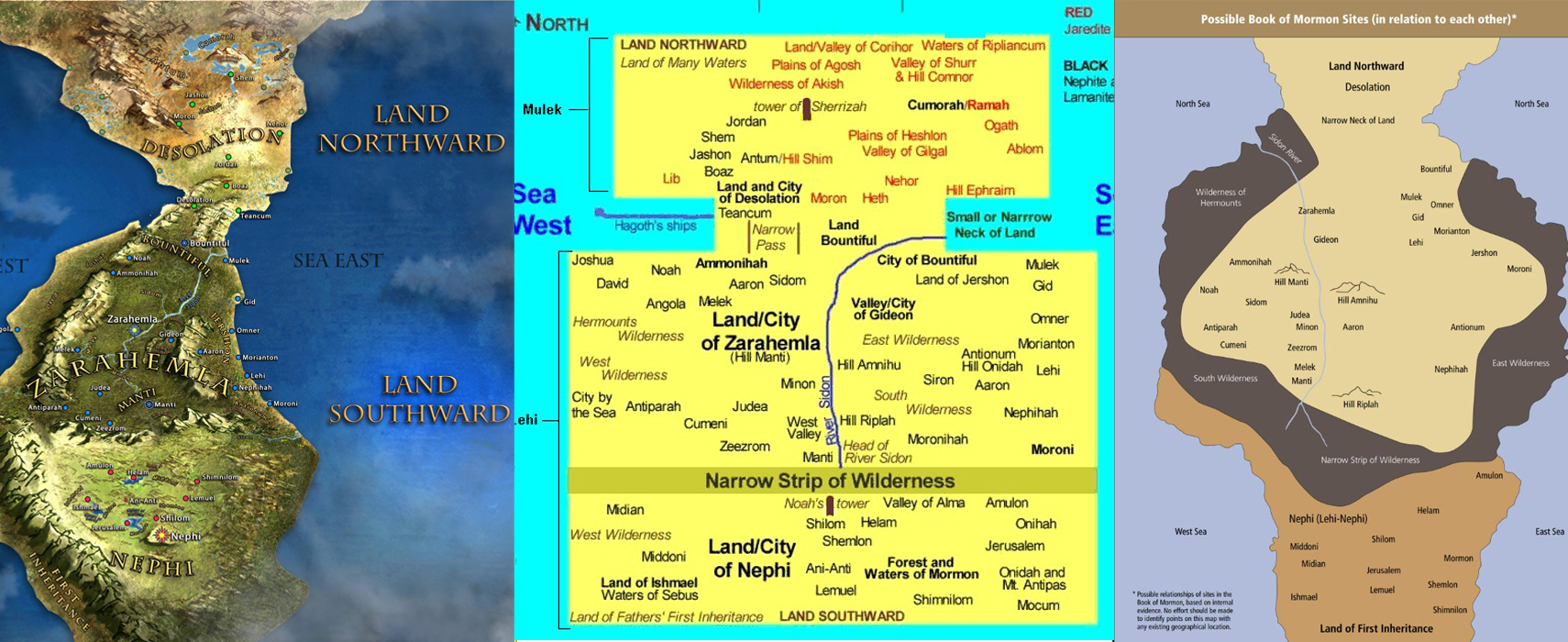
Tyler Griffins’ conceptual internal model of the Book of Mormon may be the best model yet made. Like my carefully construed internal model, his model builds off the scholarship which was developed by the old LDS institute manual geography. I think his model is as close to the text as any other I’ve seen, giving me only 2 or 3 important critiques of the model.
– ALMA 8:13 SHOWS AMMONIHAH SHOULD LIKELY BE IN PROXIMITY TO AARON . The city of Aaron is definitively placed in proximity to the cities of Moroni & Nephihah in Alma 50:14–15. In fact the language of those verses combined with the fact that the Lamanites first take both Moroni & Nephihah suggest those three cities should probably be in a line along the south, although such details are not entirely required by the text. However, Alma 8:13 strongly suggests a proximity of Ammonihah and Aaron, since this seems to be Alma’s next city of choice after leaving Ammonihah.
13 Now when the people had said this, and withstood all his words, and reviled him, and spit upon him, and caused that he should be cast out of their city, he departed thence and took his journey towards the city which was called Aaron. (Alma 8:13)
This obvious inference caused the Topical Guide to suggest that there might be TWO Aarons. Because on one hand we know Ammonihah is WEST of Sidon and three days NORTH of Melek, and yet it also seems to share proximity to Ammonihah. The text also infers a proximity of Ammonihah to Jershon (Alma 35:1–8) and the Land of Antionum. Note also the Lamanite retreat of Alma 16 from Ammonihah has an army crossing the head of Sidon while taking the captives home to the Land of Nephi. Putting Ammonihah and Noah in the north would put the army retreating directly through the west end of the Land of Zarahemla, in order to put them at the head of Sidon, which makes absolutely no sense given the context of the story. In fact, Alma 49:3,15 says that Ammonihah was twice a target of Lamanite aggression because it was an “easy prey” or convenient point of attack. So would a city north of Zarahemla really be considered an “easy target? Doesn’t a placement much closer to the Nephite/Lamanite south border make far more sense? In Alma 49 it is the SECOND time an army heads toward Manti from that area. So once again it is completely illogical to not place these two areas adjacent or somewhat close to one another along a southern border as well as suggested by Alma 31:3 & Alma 50:7.
Putting these verses together it seems logical that the Narrow Strip of wilderness and Moroni’s new border of Alma 50 likely slant a little to the southwest to give room for Melek to be three days south of Ammonihah, but yet have Ammonihah still west of Sidon and in a western location that is “easy prey” on the outskirts (likely southwest) of Zarahemla. This makes sense anyway, since far from putting the fearless mothers of Helaman’s stripling warriors way out in the northmost outskirts of Zarahemla “for their protection” it makes more sense that they relocated close to where their children were stationed on the southwest border to be able to quickly supply them with food and provisions with far more love for their sons than fear of death. If true, the 2.5 day flight of Helaman’s army in Alma 56:36–43 gives us some indication of distance, where even after running over two days (40+ miles?) the army doesn’t make it from Antiparah to Ammonihah, Noah or Zarahemla showing that these cities are more than 2-3 day journey north of Antiparah. (In my model Zarahemla is some 150 miles from Antipirah or a ten day journey, and Ammonihah is west of Zarahemla, about 130 miles from Antiparah, with Melek being about 80 miles northwest of Antiparah).
– THERE IS LITTLE REASON TO PUT TEANCUM ON THE EAST SEA . The ONLY sea mentioned in the 59 year Nephite retreat from Zarahemla to Cumorah is the WEST sea near the land of desolation, and the text seems to suggest that Desolation & Teancum are very close to each other. Even though one might assume that a city named after Teancum would be very near the city of Bountiful on the East Coast since that is where Teancum died, however strangely Bountiful is NEVER mentioned in the final retreat! If they crossed all the way to the opposite coast, doesn’t it seem strange that they wouldn’t go to Bountiful since it was NORTH of where Teancum died? Also both Mormon & Moroni are named after people and places in the land southward, suggesting a tradition of naming things in the Land Desolation after people and places in the land southward.
– ALMA 52:9 IS A BIT PROBLEMATIC. Alma 52:9, says Moroni “also sent orders unto [Teancum] that he should fortify the land Bountiful, and secure the narrow pass which led into the land northward, lest the Lamanites should obtain that point and should have power to harass them on every side.” By putting Bountiful and the “narrow pass” (which may or may not be ON the narrow neck” so far northward, this logic of having to secure the narrow pass in order to prevent the Lamanites from flanking the land of Zarahemla, since by way they have drawn it, the Lamanites would have already had power to harass them on every side. The only way this verse makes sense is if Bountiful and the narrow pass isn’t very far north of Zarahemla and is bound by a mountain by the sea or an isthmus by the sea that somehow bypassing gives easy entrance into the Land of Zarahemla.
–
Critique of the Book of Mormon Heartland Model
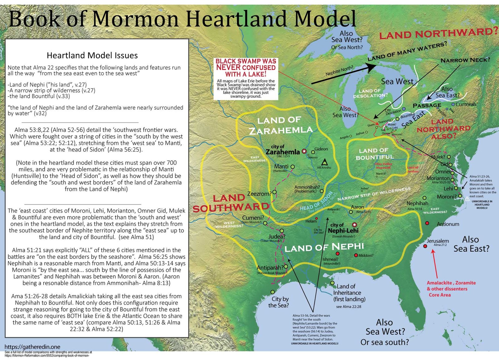
The Book of Mormon heartland model is a model revamped and popularized by Rod Meldrum and associates which places the entirety of Book of Mormon narrative in the Eastern United States of America. It seems to have arisen in response to the issues in the “limited Mesoamerican model”. These includes issues such as the ‘two Cumorah’ theory, early prophetic and apostolic quotes about Book of Mormon culture & individuals in North America, as well as the way Mesoamerican models appear to discount the many impressive North American prehistoric cultures which seem to fit well into the Book of Mormon narrative. (Issues which are detailed later in this article)
Strengths
– The greatest strength of the heartland model for most it’s believers is it’s NOT having a second land Cumorah. (See ‘Issues’ with the southern Mesoamerican model) Although it seems reasonable to suppose that the Book of Mormon’s final battle and ‘Hill Cumorah’, might not be the exact hill Joseph got the plates from, it is counter to Joseph Smith’s beliefs, and fairly problematic to suppose it is not at least relatively close to it, and at least in the the same land Cumorah. (see Cumorah in Internal Model of the Book of Mormon)
– References which obviously prophesy about the United States on ‘this land’ (ie. the land the ancient prophets lived on) simply work better for heartland. Although Mexico/Guatemala also work to some extent its simply not as good of a match for the description of a ‘land of liberty’ and U.S. revolutionary ‘freedom’ culture that seem to shine through so strongly in the text.
– Early LDS prophetic statements (as well as the account of ‘Zelph’) really work only if Nephites/Lamanites lived in North America too. (trying to make Zelph a post Nephite traveler & Joseph’s “hills of the Nephites” into post Book of Mormon migrants requires a certain level of stretching the available documentary evidence.)
– Basically see the “Issues” section for the Mesoamerican models, and you’ll see the “strengths” of the Heartland models. The heartland model’s strengths are not so much in geography as in context, ideology, and prophesy associated with the Book of Mormon and early LDS leaders.
Issues
– IT LIMITS THE BOOK OF MORMON BY IGNORING THE CONTINENTS MOST IMPRESSIVE RUINS & ANCIENT CULTURES. Just like the Limited Mesoamerican model’s betrayal of Cumorah, Heartland models betray the general sense of a continental model given in the Book of Mormon text, which clearly gives the impression that Book of Mormon narrative encompasses the whole continent from sea to sea. North to south (Canada to ancient Mesoamerican cultures) and especially east to west (as we’ll read in the following textual issues).
there was much contention and many dissensions; in the which there were an exceedingly great many who departed out of the land of Zarahemla, and went forth unto the land northward to inherit the land. 8 And it came to pass that they did multiply and spread, and did go forth from the land southward to the land northward, and did spread insomuch that they began to cover the face of the whole earth, from the sea south to the sea north, from the sea west to the sea east. (Hel 3:8)
– THE LAND OF NEHPI, NARROW STRIP OF WILDERNESS & LAND OF BOUNTIFUL (& DESOLATION) SHOULD STRETCH FROM SEA EAST TO SEA WEST. The text clearly states that at least the land of Nephi, narrow strip of wilderness and land of Bountiful stretch fully from “sea east even to the sea west”, and strongly infer by movements of armies in the battle chapters of Alma 50-59 that the southern frontier of the Land of Zarahemla stretches from the east sea to west sea as well (further explained in a later point).
27 …the king sent a proclamation throughout all the land, amongst all his people who were in all his land [Land of Nephi]… which was bordering even to the sea, on the east and on the west, and which was divided from the land of Zarahemla by a narrow strip of wilderness, which ran from the sea east even to the sea west… (Alma 22:27)
32 And now, it was only the distance of a day and a half’s journey for a Nephite, on the line Bountiful and the land Desolation, from the east to the west sea; and thus the land of Nephi and the land of Zarahemla were nearly surrounded by water… 33 And… the Nephites had inhabited the land Bountiful, even from the east unto the west sea… (see Alma 22:27–33)
It’s completely illogical to suggest the west sea of v. 32 (which heartlanders say is one or more of the Great Lakes, is different from the west sea of v. 32. given that ALL the lands are “nearly surrounded by water”. The heartland model’s Land of Nephi and narrow strip of wilderness and Land of Zarahamla are not “nearly surrounded by water” lacking the texts clear explanation of a sea to the west (see also Alma 53:8, Alma 52:11–12, Hel 3:8). Those who try to explain these problems away by calling rivers, seas or part of the ‘surrounded by water’ are stretching the text beyond its limits.
– Alma 22:28 SUGGESTS THERE IS A SEA/SEASHORE WEST OF THE LAND OF ZARAHEMLA. The text is pretty clear that there is a seashore nearby, west of the land of Zarahemla. One that Moroni later kicks the Lamanites out of, when he creates the new border between the lands of Zarahemla and Nephi (Alma 53:8–22). And that the lands are “nearly surrounded by water”. So why would we use stretches of logic to suggest that the same west sea does not stretch from the land of Bountiful & Desolation down to the land of Nephi past the land of Zarahemla?
west of the land of Zarahemla, in the borders by the seashore… (Alma 22:28)
– LAND OF FIRST INHERETANCE WAS ON A SEASHORE WEST OF THE LAND OF NEPHI (NOT SOUTH OR SOUTH-WEST). With the Eastern US heartland model, Nephi’s journey from eastern Arabia to America doesn’t really even make sense when the text says they land on a shore which they call first inheritance that was “west in the Land of Nephi” (not south in the Land of Nephi).
“the Lamanites lived in the wilderness… west of the land of Zarahemla, in the borders by the seashore, and on the west in the land of Nephi, in the place of their fathers’ first inheritance, and thus bordering along by the [west] seashore. ” (Alma 22:28–29)
So if Lake Erie is the West Sea, how would they land there? Where can you possibly place the Nephite landing “on borders by the seashore… on the west… and along the seashore” and make it fit with the Eastern United States? Do we now pretend the Gulf of Mexico is both the sea south of Hel 3:8 and the sea west? Both Alma 22:28 and Mosiah 9:1 talk about the Land of Nephi and the “land of their first inheritance, after they had crossed the sea”, as if they can be used interchangeably. (ie. the Land of First Inheritance is IN or very near the land of Nephi. We know the land of Nephi is south of the narrow neck. So once again, how can ANY model which puts the narrow neck on the Great Lakes, or the land of Nephi in the heart of the US, make the place they first landed work? (pretending they came up the Mississippi also does not work, as the text clearly states the land of first inheritance is by the “WEST SEASHORE”. Here we run into the same problem that Heartlanders blast Mesoamerican models for, where we must use stretches of logic to make a sea south (the Gulf of Mexico) into a sea west. Note also that had Moroni meant “southwest” he likely would have said so as in Alma 53:8, which specifies that the string of cities of Alma 51-53 began on the “west sea, south [border of the land of Nephite possessions]”.
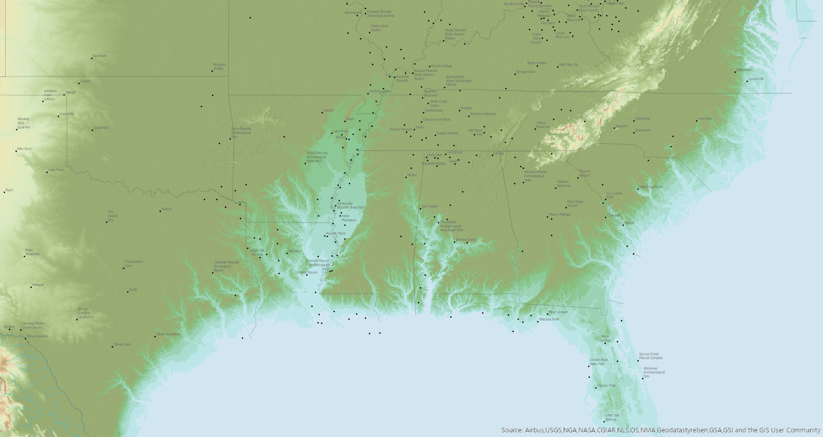
– SUPPOSING AN ANCIENT SEA UP THE MISSISSIPPI RIVER PLAIN DOES NOT WORK. Theorizing that the Gulf of Mexico used to come up the Mississippi river plain, forming an intercontinental “east sea” tongue does not work for two reasons. First there are archaeological sites like Watson Break Mounds right near the current Mississippi river at its delta that date to BEFORE the time of Christ and could not exist had it been under water. And this is true globally. Sites in Ur in Iraq or Averis in Egypt help us to understand sea level before the time of Christ, and although a bit higher, it wasn’t hugely different (see Mörner, 2015). Second, even if we did somehow suppose, contrary to the dated sites which would have been underwater, that the area of the Mississippi River was locally depressed before the time of Christ, you can see in this image to the right the approximate shoreline it would create. It simply wouldn’t come up far enough or in the right way to form a shore “east of the Land of Nephi AND the Land of Zarahemla”. (not to mention that geologically we can see the shorelines in geologic maps… (finish)
– THE MISSISSIPPI CANT BE THE HEAD OF SIDON AND THE WEST SEA. Some Heartland proponents, try and solve the ‘Head of Sidon’ issue by suggesting it is the ‘confluence’ of the Mississippi and Ohio rivers. Then those same proponents try and solve the ‘west sea’ issue by suggesting the Mississippi is ALSO the west sea in addition to the head of the River Sidon. The problem with this, in addition to the obvious unlikelihood of B.O.M. authors inconsistently calling the Atlantic the ‘east sea’ but the Mississippi the ‘west sea’, as well as the unlikelihood of calling a rivers confluence it’s ‘head’ and the unlikelihood that the confluence of the Ohio & Mississippi is the area where the armies of Alma 43:40 ‘cross the waters’– you can not have it both ways. Either it is a river or a sea, it can’t be both!
– THE MISSISSIPPI CANT BE WEST SEA. Suggesting that for some strange reason the lower Mississippi IS the west sea (as has been proposed) also DOES NOT WORK, because the Book of Mormon doesn’t just mention the west sea, but a west seashore! See Alma 22:28. It’s one thing to draw on a sketchy example of the Nile river being referred to as a sea, and suggest the lower Mississippi is the ‘west sea’ (while the Atlantic is the east sea? huh?). But quite another to say they are calling the bank of the river, a ‘seashore’.
– AN ATLANTIC CROSSING MAKES NO SENSE AT ALL. The idea that the Lehites went south to the Red Sea and Yemen, only to circumnavigate Africa and come across the Atlantic is one the most bonkers ideas of the Heartland theory. The text clearly puts the Lehite Landing ON THE WEST COAST, west of the Land of Nephi. (Alma 22:28–29) But what’s more is simply the logic that God sent them on a wild goose chase around Africa (14,000 miles) instead of just going straight through the Mediterranean to the new world (7,400 miles). If the text said they landing on the south or east sea, this argument would be a possibility (although still strange given their launch location). But leaving from Yemen it makes FAR more sense that they traveled the 16,000 miles across the pacific! I honestly don’t think many people understand that the pacific journey is only 2-3,000 miles farther than going around Africa, and has the benefit of staying in warm seas & climates and stopping by the other branches of Israel in Polynesia and South America on the way.
– LOTS OF OTHER WEST SEA PROBLEMS. Many references to the West Sea run into this same problem. (See Alma 50:11, Alma 52:12, Alma 53:8, Alma 22) Read through them here.
– STORY OF HAGOTH MAKES LITTLE SENSE IN THE GREAT LAKES. Look carefully at the wording in the reference to Hagoth who took people to the Land Northward and note some of the issues with the Heartland Models idea that the “west sea” is one of the Great Lakes and the “land northward” is Canada.
5 And it came to pass that Hagoth… went forth and built him an exceedingly large ship, on the borders of the land Bountiful, by the land Desolation, and launched it forth into the west sea, by the narrow neck which led into the land northward. 6 And behold, there were many of the Nephites who did enter therein and did sail forth with much provisions, and also many women and children; and they took their course northward… (Alma 63:5–9)
Since he builds the ship “on the borders of the land Bountiful, by the land Desolation”, that rules out the western lakes of Lake Superior & Michigan and leaves us only with Lake Huron as our ‘West Sea’ where Hagoth traveled. But think of the logic?! Verse 4 says THOUSANDS of people are heading to the land northward, so Hagoth exploits this mass exodus by helping bring provisions and hundreds more. But they travel 480 miles by foot, just to get on a boat that takes them ONLY 180 miles or so to the cold Canadian landscape? It makes SO MUCH more sense to suggest
The story of Hagoth makes little sense if the West Sea is the Great Lakes (and a completely different sea than the one mentioned concerning their first landing?). Hagoth is said to have “launched… forth into the west sea, by the narrow neck which led into the land northward” (Alma 63:5). But how do the ‘Great Lakes’ even really get you access to the Heartland Model’s “land northward” When we know that the Land Northward is where Cumorah and the final Battle take place? Really, any of the lakes would only get you access the the Narrow Neck region’s of Bountiful and perhaps desolation (places in contact with Zarahemla), but the text suggest a LARGE distance saying that the people who left, “were never heard of more” (Alma 63:8). Reading the whole account in Alma 63:5–9, makes it clear that this model stretches the Book of Mormon text past it’s logical limits. Also, a Polynesian connection to Hagoth (as proposed by many LDS apostles) is impossible in the Heartland model.
– LAND NORTHWARD MAKES NO SENSE IN CANADA. The land of Desolation which is an “exceedingly great distance” north from the Land of Zarahemla and Narrow Neck (Hel 3:8), also make very, very little sense if you try and place it in Canada. The text states that the land was the heartland of the Jaredite Civilization, covered in bones, and was “rendered desolate and without timber, because of the many inhabitants who had before inherited the land” (Hel 3:3–8). How can you get Eastern Canada to fit that description? It is almost NOWHERE devoid of timber (until you get to the uninhabitable tundra). It has essentially NO evidence of a complex ancient civilization and certainly not one that was “exceedingly expert in the working of cement” (Hel 3:7). It is SO WET that bones disintegrate within a few years, and would be unlikely to be preserved the amount of time required by the text (from the Jaredite destruction to the Nephite exploration of the area).
– LAND DESOLATION IN GREAT LAKES CANADA MAKES DOEST WORK. The land of Desolation which is an “exceedingly great distance” north from the Land of Zarahemla and Narrow Neck (Hel 3:3–4) is also, “the place of [the Mulekites] first landing” (see Alma 22:30), as well as the most likely place of Jaredite first landing or heartland “where the king dwelt” (see Ether 7:6). How can the heartland’s land of Desolation near the Michigan Peninsula fit this criteria? Niagara falls makes passage into the great lakes impassible, so the Mulekite landing would have to be Lake Ontario but that doesn’t work for the Jaredites; and certainly isn’t “northward” or an “exceeding great distance” from Zarahemla (Hel 3:3–4). In fact its only “northward” of Cumorah which goes completely contrary to the general layout of Alma 22 which seems to label the lands Nephi, Zarahemla, Bountiful, Desolation from south to north.
– ETHER SAYS THE JAREDITES LIVED PREDOMINATELY IN THE LAND NORTHWARD, BUT ADENA LIVED PREDOMINATELY IN THE HEARLAND’s LAND SOUTHWARD. In addition to the general discussion of population movements in the Book of Ether, Ether 10:21, is clear that the early Jaredite population was almost exclusively in the land Northward. Yet the Heartland model matches the Jaredites with the Adena who lived in their land southward. Ether 10:21 says,
21 And they did preserve the land southward for a wilderness, to get game. And the whole face of the land northward was covered with inhabitants. (Ether 10:21)
This simply does not match what we see in the archaeology. There is no archaeological era where the population of the Michigan Peninsula or Canada was greater than that of south of the Great lakes, which is what we should see given the Book of Mormon narrative and the heartland model.
– CUMORAH IS NOT REALLY IN THE HEARTLAND MODEL’S LAND NORTHWARD. Cumorah is SOUTH (in the land southward) of the narrow neck in the Heartland Model. The logically problematic, two Cumorah theory of Sorenson’s model is one of the reason’s the Heartland Model deservedly gains supporters. But yet the Heartland model introduces a greater problem by putting the Hill Cumorah in the Land Southward. (since their ‘Narrow Necks’ are the isthmus areas created by the Great Lakes). Mormon 2:20,29 makes it clear that the final Nephite retreat was “northward” from the Narrow Neck, and for at least 3 of the battle cities “in the borders west by the seashore” (Mormon 2:6–8, Mormon 3:8 & Mormon 4:3). There is ABSOLUTELY no indication that the Nephites fled north of the Narrow neck into the Land Northward (where a treaty was made giving them the land Northward, Mormon 2:17), only to then circle around a Great Lake and then back south through a different narrow neck, back into the Land Southward to upstate New York (Cumorah). This logic requires wild assumptions of directionality entirely opposite of those mentioned in the text.
– MISSISSIPPI RIVER IS POOR MATCH FOR RIVER SIDON. The head of Sidon is south of Zarahemla, near the land of Manti (Alma 22:27,29; Alma 43:22) which most heart landers equate with Huntsville Missouri, because of a Joseph Smith quote. This requires Heartlanders to make the “head” of the river, either it’s mouth or delta — a definition completely contrary to the 1828 dictionary (see last definition: Head– “To originate; to spring; to have its source, as a river”). Or to use twist the meaning of the word head even farther equating it with a ‘confluence’ (of the Ohio & Mississippi arms). But even this simply doesn’t work with the geography laid out in Alma 56:25 where the “head of Sidon” is mention as being a reasonably distanced march from Nephihah, which Alma 51:26 places on the East Sea.
– HUNTSVILLE & MONTROSE IOWA FOR MANTI & ZARAHEMLA ARE PROBLEMATIC. Many Heartlander proponents hold to the idea that D&C 125:3, and an obscure quote ascribed to Joseph Smith about Huntsville are proof that these sites are actually the ancient cities of Zarahemla and Manti. The problem with these ideas, however, is that D&C 125:3 Doesn’t actually say anything about the area of Montrose being Zarahemla… it only says “let the name of Zarahemla be named upon it.” Likewise, the 3rd hand quote from Samuel D. Tyler’s journal used to suggest Joseph Smith said Huntsville was “the ancient site of the City of Manti”, is countered by a conflicting quote which says instead that the Huntsville area was “the place where the city of Manti is to be built.” (History of the Church, Volume 3, pg. 144 / 3:10:144:1) More importantly, these quotes are from a July 1838 march called ‘Kirtland Camp‘, of which Joseph Smith WAS NOT EVEN A PART! Given that there is no firsthand record in any journal of what Joseph said of this matter, and there isn’t even a secondhand statement by one of Joseph’s contemporaries about it, AND ZERO credible archaeological remains have been found in either location, it seems most likely that these are misunderstandings of Joseph Smith (and the Lord) attempting to name modern cities after the names of ancient Book of Mormon cities just like Brigham Young would command be done again in Utah. (ie. Toponymic Transfer)
– RIVER CROSSINGS ARE PROBLEMATIC. The bones of those thrown into the River Sidon are said to be carried to the “sea,” (Alma 3:3) which primarily refers to the Great Lakes in the Heartland Model. The Mississippi flows into the Gulf of Mexico, far away from these “seas.” Even calling the Lakes and Ocean both ‘seas’, the same verses say the armies crossed the river Sidon before battling on its banks and then throwing bodies into it. This suggests a river small enough to easily cross without canoes (Alma 2:34–35). But large and seasonally flooding enough to throw bodies into and know they will end up in the sea.
– DNA EVIDENCE IS PROBLEMATIC. Many Heartlanders use the existence of haplogroup X in northeast native populations to suggest their model is genetically a better match than Mesoamerica. Haplogroup X genetic populations are found in the Ojibwe (25%), Sioux (15%), Nuu-Chah-Nulth (12%), Georgia (8%), Orkney (7%), and amongst the Druze Assyrian community in Israel (27%). However, the problem with assuming that this halplogroup came to the America’s with Lehites instead of early groups in its existence in the genetics of older Paleo-Indian individuals such as Kennewick Man (dated to 8,400 BC Mitochondrial haplogroup X2a) and Anzick-1 (dated to 11,000 BC with same x2 subclade).
– The Heartland Model has the land Bountiful southeast of Zarahemla; the Book of Mormon has it northward.
– The Heartland Model elsewhere claims that Bountiful is directly north of the land of Nephi; in the Book of Mormon, Zarahemla is directly north of the land of Nephi.
– The Book of Mormon has the sea west to the west of the Zarahemla and the land of Bountiful, but the Heartland Model has it east of Zarahemla and north of Bountiful.
– Heartland Model uses a city founded by Mormons near Nauvoo (named “Zarahemla) to locate the Nephite city of Zarahemla. The model ignores that it was settlers who started calling it Zarahemla first, not scripture or Joseph Smith. The lines about Zarahemla were added later, for historical clarity, by an editor when the revelation was published.
– Likewise, a city called “Manti” was ascribed to the prophet by later editors, but it was not in the original text.
– Heartland Model relies on Hopewell cultural dates matching B.O.M. dates, but the locations of Zarahemla, Nephi, and Manti used in most models dont match any major Hopewell sites (are evidence of prehistoric settlement at all)!
– The Heartland Model poorly matches evidence and research on population sizes and growth.
Adapted from the more comprehensive list found at bmaf. (first adapted from a list compiled by Gregory Smith)…
– BOOK OF MORMON ‘SEAS’ WERE NOT LAKES, THEY WERE OCEANS. Heartlanders try to suggest that in the same way that the Bible called the lakes, Sea of Gaililee or Dead Sea, seas, that the Book of Mormon authors also called lakes sea. This theory, however, is disproven by the text. Since the ONLY references the oceans (where we unambiguously know the text is referring to the ocean), it is called the ‘sea’.
13 …it came to pass that the Lord did bring Jared and his brethren forth even to that great sea which divideth the lands. (Ether 2:13)
5 And we did come to the land which we called Bountiful… And we beheld the sea, which we called Irreantum, which, being interpreted, is many waters. 6 And it came to pass that we did pitch our tents by the seashore; (1 Nephi 17:5–6)
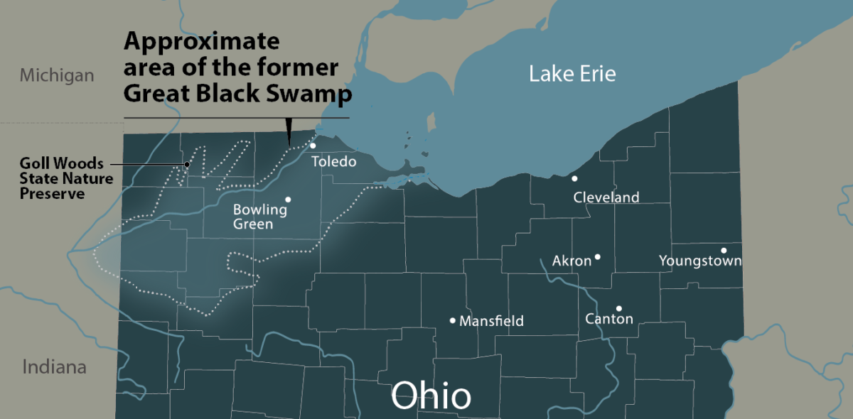
– GREAT BLACK SWAMP THEORIES ARE BONKERS. Many Heartlanders try to create an imaginary pre-colonial ‘narrow neck of land’ between Lake Erie and Lake Michigan by supposing that the ‘Great Black Swamp‘ used to extend the shores of Lake Erie some 100 miles to the west, making the entrance to the Michigan Peninsula much narrower. This theory however, is a blatant misrepresentation of the evidence for the Great Black Swamp. What heartlanders who push this theory fail to accept is that it was ONLY a swampy area, and NO ONE confused it with part of Lake Erie or a sea. How do we know? There’s dozens (if not hundreds) of maps from before it was drained. Some as early as the 1600’s & 1700’s. in EVERY ONE OF THEM the shoreline of Lake Erie is similar to what it is today! (google image search ‘earliest maps of great lakes’ for yourself!) They knew the difference between a marsh and a Lake/Shoreline. And there’s ZERO geological evidence it was deeper BC. In fact the area HAS AND HAD THE MAUMEE RIVER RUNNING RIGHT THROUGH THE MIDDLE OF IT! No one was going to confuse it with a lake or sea, because it wasn’t anything like a lake or a sea. It was a swampy area with rivers and creeks flowing right down the middle of it.


–
Critique of the Limited Mesoamerican or Mayanland Models
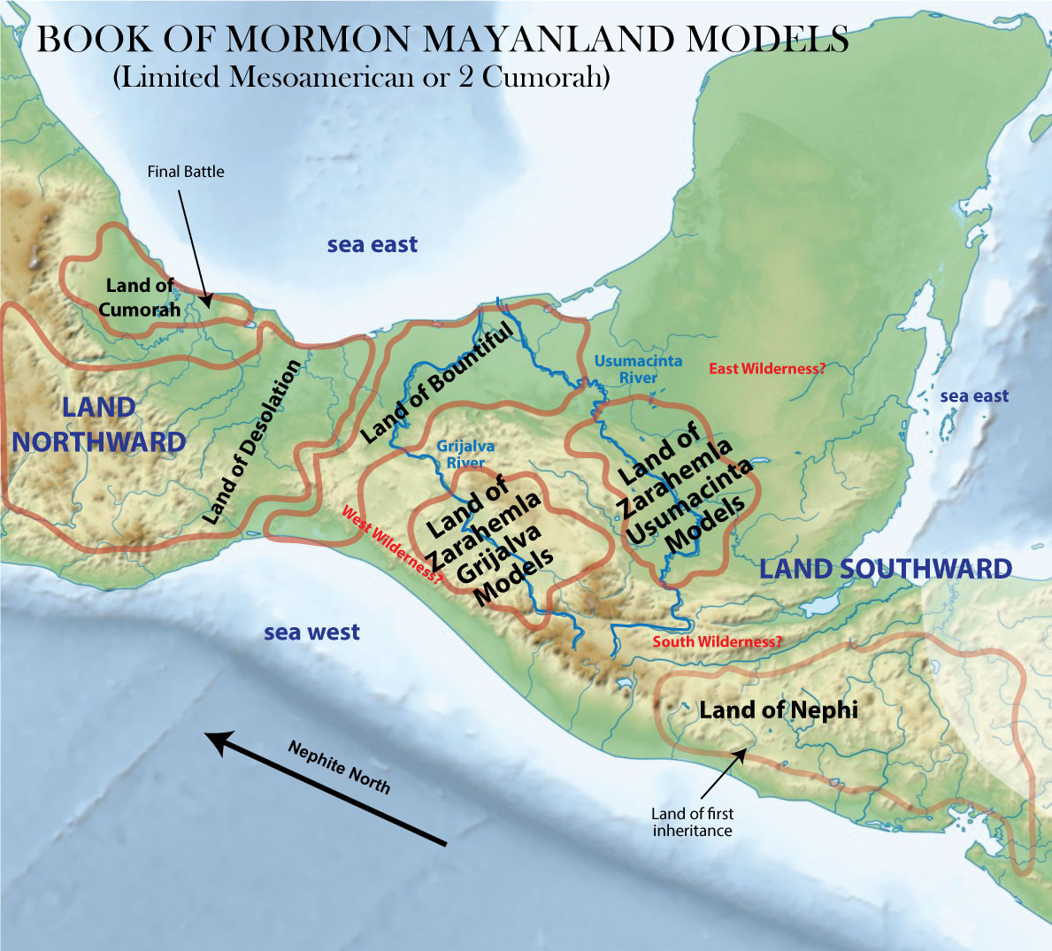
The majority of Mesoamerican Book of Mormon geography models seek to correlate the Isthmus of Tehuantepec or the Isthmus of Guatemala with the Book of Mormon “Narrow Neck”. In my analysis, I only cover the former, as the latter do not seem very plausible (although many of the issues below cover those models as well). Mesoamerican models in general far exceed the heartland models in their ability to synthesize the text with known archaeology. However, all of these models suffer many of the same substantial problems which gave rise to the Heartland models (ie. excluding 95% of the continent and its ancient cultures from the B.O.M. narrative as well as many prophetic statements and common-sense readings of the text). Despite the many issues listed below, I find the Usumacinta/Tonina/Kaminaljuyu the most convincing of the Mesoamerican models, and a true candidate for a valid possibility to the text; although still inferior to the continental model. Grijalva models come in third behind Usumacinta & Highland model, but only when 2 Cumorah ideas are discarded, and Sorenson’s ‘east cities’ stretch from Belize to Tehuantepec instead of all being all Tehuantepec.
Strengths
– The cultural correlations of the limited Mesoamerican models are fantastic. You could make 100 “strength bullet points” from these alone. Probably a few of the most unique are things like how Maya and their culture and climate fit well with many Book of Mormon statements. Although forcing BOTH the Nephites and Lamanites (including Mulekites and all other ‘ites’) into the Mayan culture seems more monolithic than we should suppose. If the Mulekites culturally evolved for hundreds of years completely separate in language & religion from the Nephites, it would almost certainly show up as a distinctly different culture.
– Kaminaljuyu (Guatemala City) as Nephi works pretty well both temporally and geographically.
– Tonina and Palenque are at least fair geographic matches for Zarahemla. Their relationship west of the Usumacinta River (Sidon) fits well with the text. Also their dates of establishment could possibly work with the text (200 BC). (However, their rise and fall does not fit well, as their populations seem abysmally small before the time of Christ, and only reach significance long after the time of Christ. — As opposed to Grijalva models which have abysmally small populations both before but especially after the time of Christ).
– The isthmus of Guatemala and Motagua Valley/Ridge work fairly well as the ‘narrow strip of wilderness’ separating the lands of Nephi and Zarahemla. It’s an obvious geographic barrier, with the ‘head of Sidon’ (headwaters of the Usumacinta River) right there in the narrow wilderness strip where the text demands (except that the north/south directionality is completely wrong).
Issues
Like the Heartland model, Limited Mesoamerican Models must ignore the overwhelming consensus of Joseph Smith and other early prophetic views that supported a Continental model. A view strongly suggested by the Book of Mormon text itself (see Hel 3:8). Especially statements concerning Zelph and New England Nephite occupation. Also scriptural assertions that at least the land, if not hill, ‘Cumorah’ is in New England where the angel Moroni appeared to Joseph Smith in vision. Also the many, many instances in the Book of Mormon which essentially prophesy of a future nation of freedom (despite attempts to explain this away, it really is unmistakably includes the U.S.) being built upon the same lands as Mormon seemed to live on. Instead, they force the Book of Mormon into a small corner of Central America which directions that absolutely contradict the text (see Alma 22). They correlate all Book of Mormon lands and peoples with merely two Mesoamerican people’s (Maya & Olmec), while almost entirely ignoring the largest and most influential cultures on the continent (Adena, Hopewell, Anasazi/Ancient Puebloan, Mexican Highland/Teotihuacan, Zapotec, Mixtec, Huestec, Parapucha, etc).
– TWO CUMORAHS ARE CONTRADICTED BY 1 NEPHI 22/3 NEPHI 21 PROPHESIES – Putting the entirety of the Book of Mormon into a pocket of Mesoamerica without the Nephite ‘Land Northward’ being in the present United States, makes the statements and prophesies of Nephi illogical. According to Nephi, the “mighty nation” which is lifted up by God “above all other nations” (see 1 Nephi 13:30) was to be founded on “this land” and scatter “our seed”, and most importantly, be “set up as a free people” by God (3 Nephi 21:4). Mexico didn’t get its freedom from Spain until 1821, and by then it was among the weakest nations in the developed world. So suggesting this mighty nation of free people was Spain or Mexico just doesn’t make a lot of sense. The only rational interpretation of this and other similar scriptures is that Book of Mormon prophets considered the territory to be occupied by the future United States their land, and knew their seed would inhabit it. This is why the plates were hid in New York, not Mexico… because the destiny of the United States of America was founded on the promises made to Book of Mormon people who inhabited parts of the same land.
7 And it meaneth that the time cometh that after all the house of Israel have been scattered and confounded, that the Lord God will raise up a mighty nation among the Gentiles, yea, even upon the face OF THIS LAND; and by them shall our seed be scattered. (1 Nephi 22:7)
4 For it is wisdom in the Father that [the gentiles] should be established IN THIS LAND, and be set up as a free people by the power of the Father, that these things might come forth from them unto a remnant of your seed, (3 Nephi 21:4)
Two Cumorah proponents need to make up their minds. The question comes down to, is the modern US part of the ancient Nephites lands or not? (ie. part of what Mormon & Jesus would refer as “this land”) If no, the above scriptures make little sense. If yes–and its part of the Nephite “Land Northward” (see Alma 22:30–33; 46:22; 50:11, 29–34; 63:4–10; Helaman 3:3, 8–11), then it makes FAR more sense that Cumorah is in New York, since Mormon 2:29 calls the region the Nephite flee to “the land northward” AND its its in a land of many lakes streams and waters, AND its south of ‘great waters’ that ‘exceed all’. You CANNOT suggest Hel 3’s “whole earth” DOESN’T include North America, and yet suggest 1 Nephi 22:7 & 3 Nephi 21:4’s “this land” does! You must make up your mind!
8 And it came to pass that they did multiply and spread, and did go forth from the land southward to the land northward, and did spread insomuch that they began to cover the face of the whole earth, from the sea south to the sea north, from the sea west to the sea east. 9 And the people who were in the land northward did dwell in tents, and in houses of cement… (Hel 3:8–9)
– TWO CUMORAHS ARE CONTRADICTED BY THE D&C AND JOSEPH SMITH – Just as Joseph Smith consistently pushed a continental model, he also consistently pushed the idea that the Hill Cumorah in New York where he claimed to find the plates was the same Cumorah mentioned in the Book of Mormon . D&C 128:20 seems to clearly insinuate that the Angel Moroni’s visit to Joseph Smith was at least in the land Cumorah. So even if one were to speculate that the hill Cumorah which Mormon hid ALL the Nephite records in his possession (Mormon 6:6 — probably in an old mine of some sort), “by” where the battle took place (Mormon 6:2), suggesting Cumorah is actually in Mexico is to make D&C 128:20 a false statement.
“20 And again, what do we hear? Glad tidings from Cumorah! Moroni, an angel from heaven, declaring the fulfilment of the prophets—the book to be revealed. A voice of the Lord in the wilderness of Fayette, Seneca county, declaring the three witnesses to bear record of the book! The voice of Michael on the banks of the Susquehanna…” (D&C 128:20)
– TWO CUMORAHS ARE CONTRADICTED BY MORONI 1:1. Although the text never calls the hill where Moroni buries his abridged plates ‘Cumorah’ think of the logic of two Cumorah’s in regard to Moroni 1:1 where he says,
“Now I, Moroni, after having made an end of abridging the account of the people of Jared, I had supposed not to have written more, but I have not as yet perished…” (Moroni 1:1)
…for I am alone. My father hath been slain in battle, and all my kinsfolk, and I have not friends nor whither to go; and how long the Lord will suffer that I may live I know not. (Mormon 8:5)
This suggests Moroni was unsure when he was going to be killed by Lamanites! This is incredibly important, as we can assume from this that he almost certainly would have hidden the plates before the final battle, at the same time his father & other leaders hid ALL the records (Mormon 6:6), so as to not risk having the record falling into enemy hands before the last of the final battle! Mormon 6:12 says Moroni lead a legion of 10,000 in battle, so then even if Mormon 6:6 suggests that Mormon hid up “all the records… save it were [the] few plates which [he] gave unto [his] son”, we’ve got to imagine that Moroni dying with his 10,000 was a possibility so he must have put the abridged plates in their safe place where they could be found by the latter-day gentiles. (The abridged history being important that the Gentiles “have first” before God revealed the rest the records. 3 Ne 26:9) Then… when he surprisingly doesn’t “perish”, he must have gone back to their hiding place, and ‘written more’ (Moroni 1:1). So although idea that Moroni travelled long distances after the final battle is entirely plausible, The idea that he travelled long distances WITH the plates doesn’t make much sense. It would involve WAY TOO MUCH RISK of being killed on the journey and allowing the plates to fall into enemy hands (see Moroni 1:3–4, Mormon 5:12). It would appear that he assured their safety by leaving them in their hiding place between the time(s) he went BACK to that hiding place and ‘wrote more’ (the Books of Ether &Mormon/ Moroni) before his final demise.
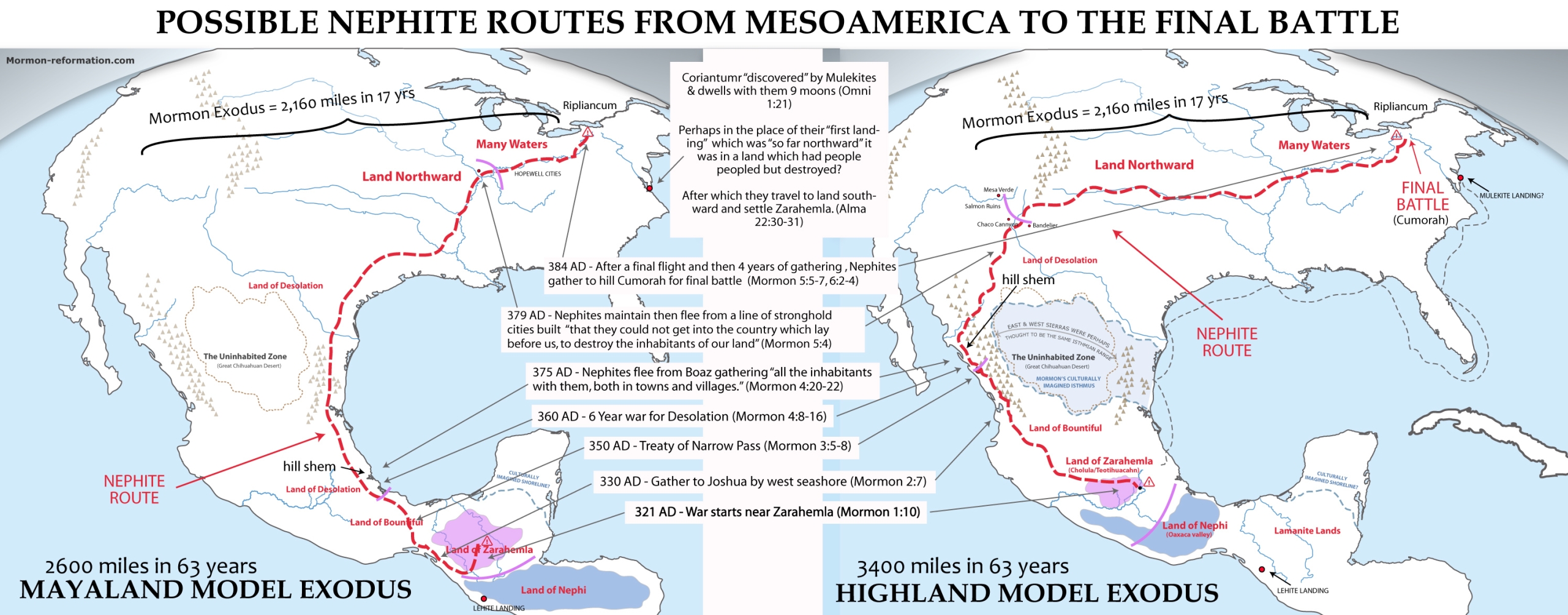
– TWO CUMORAHS ARE GENERALLY ILLOGICAL. Limited Mesoamerican Models require a “two Cumorah theory” making Moroni’s Cumorah different than Joseph Smith’s Cumorah (Mormon 6:2: vs D&C 128:20). With 2 Cumorah’s, Moroni sneaks about alone trying not to be discovered (Mormon 8:3–5, Moroni 1:1–3) with the heavy plates over 1,900 miles after the final battle which they suggest happened somewhere in southern Veracruz Mexico to get to New York to bury the plates. While suggesting that Cumorah and the final battle are ONLY around 100 miles from the ‘Narrow Neck’, which requires the readers to believe that Mormon for some confusing reason, took all the records from the Hill Shim in desolation (when the Lamanites looked to ‘overthrow the land’- Mormon 4:23), only to transport them to a new random hill only 100 miles away. One which had very little strategic or geographic advantage, where they still exist to this day–completely separate from the region in upstate New York where the Book of Mormon would be buried for Joseph Smith. Think about this–-when the early LDS saints fled from Ohio and Nauvoo; 30,000-70,000 people fled over 1,500 miles to find safety and a new home. In fact they traveled over 2100 miles over 17 years building several cities between New York & Utah. So why would 300,000 Nephites, flee only 100-250 miles building no traceable cities over a 50+ year period? Especially when a flight up the Caribbean coast toward Texas would have been so easy?!
The text gives no indication they were being hedged in from the north by some other group, and SURELY would say if a force larger than their 250,000 were hemming them in! Besides, with their massive army ready to make a stand or die, they surely would have attempted to cut their way through the Huestec lands in search for a northern land to settle. In fact think of this in light of how the Nephites prevented the people of Moranton (Alma 50:31–35) AND the Amalickiahites (Alma 51:30) from fleeing into the NEPHITE land northward. In fact a last stand of such a huge group consisting of men, women and children really only makes sense if they were forced SO far north (ie. New York) that they reached the edge of the habitable continent and had nowhere left to flee because of Great Lakes (Ripliancum) and coming winter. And since this is where the plates were found AND where prophetic visions put the last battle, WHY ON EARTH would anyone try and conceive a second Cumorah in Mexico only a few hundred miles from Zarahemla?! This illogical proposal has effectively split the church and given birth to the even poorer heartland models. Those who believe and push this theory, do a great injustice to Book of Mormon geographic correlation.
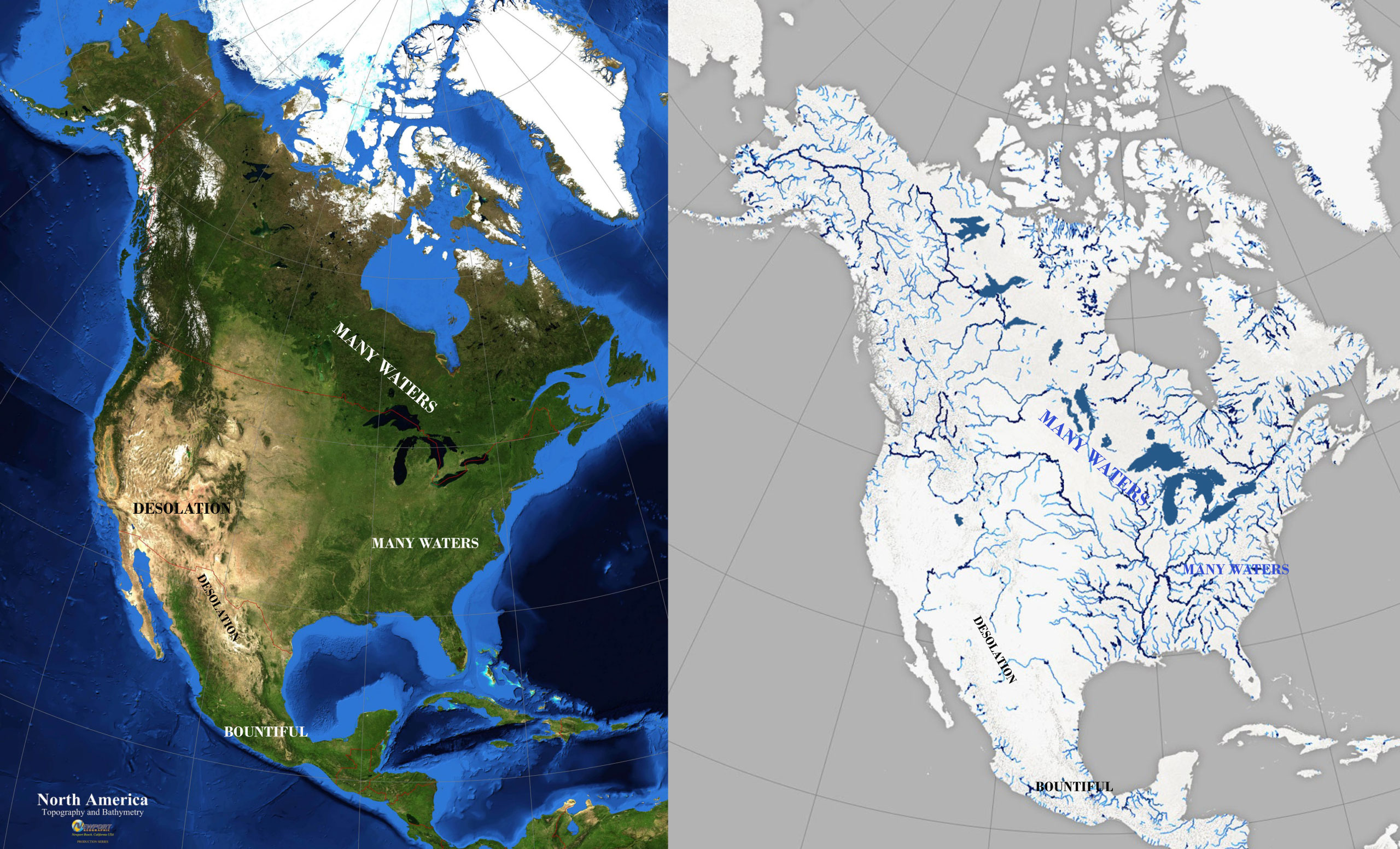
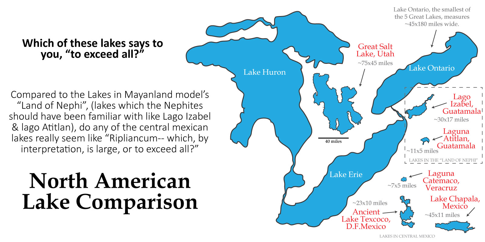
– LAND OF MANY WATERS OR LARGE BODIES OR ‘LARGE BODIES OF WATER AND MANY RIVERS IS OBVIOUSLY NORTHERN-MOST NORTH AMERICA (EASTERN US & CANADA). It stretches one’s imagination to the limits to suggest that the following four verses in the Book of Mormon are referring somewhere like the Valley of Mexico or Vera Cruz. The text says these locations are “an exceedingly great distance” from Zarahemla, and contained “many waters” and “many rivers” and “many large bodies of water”. To cultures familiar with Lake Izabal and Lago de Ititlan in Guatemala or the Grijalva & Usumacinta river systems in Mexico to refer to the Lakes of the Mexican Highland such as Texcoco or Chapala in following manner is almost laughable when contrasted with the clearly obvious region around Joseph Smith’s ‘Cumorah’ of the Great Lakes or Rivers and springs of the Canadian shield or Upper Mississippi River systems.
3 And… there were an exceedingly great many who departed out of the land of Zarahemla, and went forth unto the land northward to inherit the land. 4 And they did travel to an exceedingly great distance, insomuch that they came to large bodies of water and many rivers. 5 Yea, and even they did spread forth into all parts of the land, (Hel 3:3–5)
29 Therefore, Morianton put it into their hearts that they should flee to the land which was northward, which was covered with large bodies of water, and take possession of the land which was northward. (Alma 50:29)
8 And they were lost in the wilderness for the space of many days, yet they were diligent, and found not the land of Zarahemla but returned to this land, having traveled in a land among many waters, having discovered a land which was… covered with ruins of buildings of every kind, having discovered a land which had been peopled with a people who were as numerous as the hosts of Israel. (Mosiah 8:8)
4 And it came to pass that we did march forth to the land of Cumorah, and we did pitch our tents around about the hill Cumorah; and it was in a land of many waters, rivers, and fountains (Mormon 6:4)
Below is a comparison of Guatamala’s Lago Izabel, in the Mayanland model’s Land of Nephi, compared to the Lakes of Coastal Veracruz and the Mexican Highland & Great Salt Lake and then the Great Lakes. As you can see, there’s not much
– TIMBER BEING SCARSE IN THE LAND DESOLATION IS PROBLEMATIC. The land of Desolation is said to be desolate because of the Jaredites who were destroyed AND desolate “save it was for timber” or in other words it was desolate or devoid of timber so that the people who live in it had to “live in tents” and become expert in making “houses of cement”. Mayanland models must make the same case as Heartlanders in suggesting that regions which abound in wood and timber must have been “deforested” by the Jaredites in a manner that still left them without timber HUNDREDS of years later. This seems unlikely both in Heartlands Canada and Michigan Peninsula, as well as in Mayanlands south-central Mexico. More importantly, the use of cement in Oaxaca or the Mexican Highland was no more prevalent than its use in mayanlands making the following statement a bit problematic.
6 And now no part of the land was desolate, save it were for timber [in other words he’s using the definition of desolate meaning an area devoid of trees, not people]; but because of the greatness of the destruction of the people who had before inhabited the land it was called desolate. 7 And there being but little timber upon the face of the land, nevertheless the people who went forth became exceedingly expert in the working of cement; therefore they did build houses of cement, in the which they did dwell. 8 And it came to pass that they did multiply and spread, and did go forth from the land southward to the land northward, and did spread insomuch that they began to cover the face of the whole earth, from the sea south to the sea north, from the sea west to the sea east. 9 And the people who were in the land northward did dwell in tents, and in houses of cement, and they did suffer whatsoever tree should spring up upon the face of the land that it should grow up, that in time they might have timber to build their houses, yea, their cities, and their temples, and their synagogues, and their sanctuaries, and all manner of their buildings. 10 And it came to pass as timber was exceedingly scarce in the land northward, they did send forth much by the way of shipping. (Hel 3:6–11)
Both the Mayan and Mexican Highland cultures really PREDOMINATELY built their temples and city centers of stone. With few exceptions, their homes were primarily wood. Really only the Desert Southwest was desolate of timber to the point of mostly using teepees, wikiups or stone and cement (adobe) for ALL aspects of cultural building. And really only the US Plains Indians could be said to have culturally lived predominately in ‘tents’ or teepees.
– WEST COAST HAGOTH MAKES NO SENSE. The story of Hagoth traveling to “the land Northward” from the west sea, just doesn’t make much sense in these models. If the Land Northward is composed of areas like the Mexican Highland, Valley of Mexico or southern area of Veracruz, then why would Hagoth launch from the west sea to get there? Only the East Sea would get you closer to these areas. It makes no sense both from a launch point and destination route. If the Nephite ‘Land Northward is Veracruz, and if Sidon is the Usumacinta/Grijalva which go directly to the Caribbean, why not boat down Sidon to the port and head north along the East Coast?
Similarly, if Zarahemla is the Chiapas basin (Santa Rosa) why not leave from the harbors just west of there? Why go so far from the good lumber of the Chiapas mountains and go all the way up to Bountiful? A west coast of Bountiful launch ONLY MAKES SENSE if Zarahemla is on the Usamacinta, and the ‘Land Northward’ includes West Mexico, the known trade routes into the southwest U.S. Anasazi lands through the gulf of California, and perhaps the entire west coast of America.
4 And it came to pass… there was a large company of men, even to the amount of five thousand and four hundred men, with their wives and their children, departed out of the land of Zarahemla into the land which was northward. 5 And it came to pass that Hagoth, he being an exceedingly curious man, therefore he went forth and built him an exceedingly large ship, on the borders of the land Bountiful, by the land Desolation, and launched it forth into the west sea, by the narrow neck which led into the land northward. 6 And behold, there were many of the Nephites who did enter therein and did sail forth with much provisions, and also many women and children; and they took their course northward. And thus ended the thirty and seventh year. 7 And in the thirty and eighth year, this man built other ships. And the first ship did also return, and many more people did enter into it; and they also took much provisions, and set out again to the land northward. 8 And it came to pass that they were never heard of more. And we suppose that they were drowned in the depths of the sea. And it came to pass that one other ship also did sail forth; and whither she did go we know not. 9 And it came to pass that in this year there were many people who went forth into the land northward. (Alma 63:4–9)
– VERY FEW GOOD CITY MATCHES WITH SIGNIFICANT ARCHAEOLGICAL SITES. Although Mayan models do a good job at finding cultural correlations, none of them have done a very good job at really matching individuals Book of Mormon cities with notable archaeological ruins (with the exception of Kaminaljuyú). In my opinion, none of them can match Zarahemla with convincing archaeological ruins which match the level of prominence and significance afforded these cities in the text. Particularly in the case of Zarahemla and Sorenson’s Santa Rosa. Santa Rosa is pathetically small (< 20k), smaller than his match for Sidon (Chiapa de Corzo). I love what Michael Coe says here about BOM cities.. he hits it right on the head when he talks about how the Valley of Mexico really was the only Mesoamerican region with Old World-like populations and features like the Book of Mormon insinuates, in the Mesoamerican pre-classic.
– MANY OF THE SPECIES IN THE ANIMAL LISTS IN THE BOOK OF MORMON ARE OUT OF PLACE SOUTH OF TEOHUANTEPEC. See my article Animals in the Book of Mormon for examples of this. Specific differentiation between animals like asses (mule deer) and horses (elk, possible white tailed deer), and goats (pronghorn) verses wild goats (North American Mountain Goat), sheep (North American mountain sheep, which are on the Jaredite list and never ranged far into Mexico) as well as “cattle, of oxen, and cows” (bison, possibly tapir, musk ox) are incredibly problematic if you put the whole book of Mormon south of Tehuantepec (especially in the Jaredite list).
– MAYANLAND MODELS DO NOT HAVE ANY ARCHAEOLOGICAL EVIDENCE OF NORTHERN LANDS BEING ‘EMPTIED’, ABANDONED OR DESTROYED. These models usually identify Veracruz or the Mexican Highland as “the land northward”… yet in Mormon’s description of the final flight to “Cumorah”, the land northward is said to be emptied of its inhabitants (Mormon 5:5).
4 And it came to pass that they came against us again, and we did maintain the city. And there were also other cities which were maintained by the Nephites, which strongholds did cut them off that they could not get into the country which lay before us, to destroy the inhabitants of our land. 5 But it came to pass that whatsoever lands we had passed by, and the inhabitants thereof were not gathered in, were destroyed by the Lamanites, and their towns, and villages, and cities were burned with fire; and thus three hundred and seventy and nine years passed away. 7 …and those whose flight was swifter than the Lamanites’ did escape, and those whose flight did not exceed the Lamanites’ were swept down and destroyed.
We see no such occurrence in the archaeology. In fact that logic of the final battle MAKES NO SENSE given what we know of Teotihuacan. Why wouldn’t the Nephites make an alliance with them, if they were part of their northern ally cultures which they had been ‘guarding’ (ie. protecting the narrow neck – Alma 22:33) for nearly a thousand years? It also makes no sense in relation to the final Battle… why did Teotihuacan not get involved if the Nephites fled into their land in Veracruz to escape the Lamanite army?
– HOW COULD THE ZAPOTEC & TEOTIHUACAN EMPIRES BE OMITTED FROM THE BOOK OF MORMON WHEN THEY WOULD HAVE BEEN SO INCREDIBLY RELEVENT TO THE REGION? Teotihuacan and the Mexican highland culture, the largest and most influential city and culture in prehistoric North America, is mysteriously scant or absent from the Book of Mormon in these models (as well as Zapotec culture). Even though the Teotihuacano zenith might have post-dated the date given for Nephite destruction, it was still a rapidly growing regional influence which by 420 AD eclipsing any of the cultures put forth for Zarahemla in predominate Mayan models.
– SAYING THE ZAPOTECS & TEOTIHUACANOS ARE GADIANTONS MAKES THE IDEA OF GUARDING THE NARROW NECK ILLOGICAL. The guarding of the “narrow neck” in preservation of “the land northward” doesn’t make much sense in these models for reasons mentioned above. For instance, what culture are they guarding? Teotihuacan? The Zapotecs? That’s like Guatemala guarding the United States! Even at 100 BC, the Zapotec, and cities of the Mexican Highland (Cuicuilco, Cholula, Teotihuacan area) was FAR more populous and powerful than anything along the Grijalva or Usumacinta. Those empires would have been guarding/dominating the Nephite lands, not the other way around. Teotihuacan was the most powerful hegemon on the continent by 300 AD, so if they are the Nephites in the land Northward, why didn’t they aid the Nephites in the Final Battle, and why does the text describe a scene where the Nephites after retreating from Zarahemla and desolation “did cut [the Lamanites] off that they could not get into the country which lay before us, to destroy the inhabitants of our land” (Mormon 5:4). If Teotihuacan is the land northward, THE TEOTIHUACANOS would have sent an army and squashed the Lamanite forces. From all we can tell from the archaeology, Teotihuacan was the regional hegemon. (Remember that Mormon was from Jordan near the Narrow Neck, and there is simply nothing in the text to forward the idea that Monte Alban, Teotihuacan or any highland cultures helped in the war–had they helped in the war the tens of thousands of Nephite woman and children SURELY would have been sent there before the final battle instead of fighting to the death with no hope like cornered animals as the text suggests).
– THE ZAPOTECS & TEOTIHUACANOS AS GADIANTONS DOES NOT FIT THE TEXT OR THE ARCHAEOLOGY. Note the Book of Mormon clearly paints the Gadianton robbers or ‘band’ as mountain dwelling guerilla band as well as a mafia like secrete society which dwells WITHIN the Nephite and Lamanite societies. The text does not suggest they are a full fledged independent nation or empire like the Lamanite or Nephite nation, and their one attempt to create a city or polity is explicitly destroyed by God at the death of Christ (3 Ne 9:9). To suggest Jacobugath and the Gadiantons go on to become two of the largest and most influential empire nations on the continent does not honor the picture painted in the Book of Mormon. Teotihuacan is founded by at least 100 BC, beginning its monumental architecture by 50 BC, and reaching its Zenith by 350 AD. Read these descriptions carefully and then lets compare this with the Zapotec & Teotihuacan empires and cultures.
23 And it came to pass in the forty and ninth year of the reign of the judges, there was continual peace established in the land, all save it were the secret combinations which Gadianton the robber had established in the more settled parts of the land, which at that time were not known unto those who were at the head of government; therefore they were not destroyed out of the land. (Hel 3:23)
18 And now behold, those murderers and plunderers were a band who had been formed by Kishkumen and Gadianton. And now it had come to pass that there were many, even among the Nephites, of Gadianton’s band. But behold, they were more numerous among the more wicked part of the Lamanites. And they were called Gadianton’s robbers and murderers. (Hel 6:18)
1 …the Gadianton robbers, who dwelt upon the mountains, who did infest the land; for so strong were their holds and their secret places that the people could not overpower them; therefore they did commit many murders, and did do much slaughter among the people.” (3 Ne 1:27), 17 …and…the war between the robbers and the people of Nephi did continue and did become exceedingly sore; nevertheless, the people of Nephi did gain some advantage of the robbers, insomuch that they did drive them back out of their lands into the mountains and into their secret places. (3 Ne 2:17)
18 And these Gadianton robbers, who were among the Lamanites, did infest the land, insomuch that the inhabitants thereof began to hide up their treasures in the earth; and they became slippery, (Mormon 1:18)
There is only one indication in the Book of Mormon that the Gadianton Robbers start their own culture or city (3 Ne 7:9–12). But this city is not created until ~30 AD, and then is burned or destroyed at the death of Christ (3 Ne 9:9). There is certainly no indication that they pioneer or take over multiple empires which are among THE MOST POWERFUL EMPIRES ON THE CONENTENT both before and after the time of Christ. Note the Zapotecs of San Jose Migote, Monte Alban and the Valley of Oaxaca are founded around 1200-600 BC, and by 300 BC already likely are the largest militaristic society in the Americas at the time (see here). Indeed, orders of magnitude larger and more powerful than emerging Mayan societies like Kaminaljuyu (City of Nephi in his model) or Chiapa de Corzo/Santa Rosa (land of Zerahemla in his model) during formative times. Likewise the central cities of the Teotihuacan empire grown out of formative cities like Cuicuilco, Ticomán, El Terremote, Coapexco, El Arbolillo and Chalcatzingo; all of which were established around 1000 BC with close ties to Olmec cultures and which mostly continued into classic times and had grown into an empire for larger than anything existing in the Mayanlands by 300 AD.
The only indication The Book of Mormon gives that there could be an alliance between the Lamanites of the final battles and some other group is Mormon 1 & 2 where the Gadianton robbers who are said to be “among the Lamanites” (Mormon 1:18), seem to be involved in both the fighting and a ten year treaty. But read the verse concerning this carefully and note how crazy it would be for Mormon to omit the fact that the Gadiantons (Teotihuacahn & Zapotec Empires) actually owned essentially ALL the land north of the final battle and were hemming in their position (as most 2 Cumorah proponents propose concerning the final battle).
18 And these Gadianton robbers, who were among the Lamanites, did infest the land… (Mormon 1:18)
27 …But behold, we did go forth against the Lamanites and the robbers of Gadianton, until we had again taken possession of the lands of our inheritance. 28 And the three hundred and forty and ninth year had passed away. And in the three hundred and fiftieth year we made a treaty with the Lamanites and the robbers of Gadianton, in which we did get the lands of our inheritance divided. 29 And the Lamanites did give unto us the land northward, yea, even to the narrow passage which led into the land southward. And we did give unto the Lamanites all the land southward. (Mormon 2:27–29)
What those proposing that the Zapotecs and Teotihuacanos are ‘Gadianton Robbers’ are suggesting is that this verse should read, “the Lamanites did give unto us the [tiny portion of the land northward along the east sea], yea, even to the narrow passage which led into the land southward. And we did give unto the Lamanites all the land southward [and we did remain hemmed in, leaving the Gadiantons possessing essentially ALL the land north of us because they were indeed far too large and powerful for us with our 300,000 to attempt to fight with].
– GRIJALVA AND UCUMACINAT SIZE COULD BE AN ISSUE. The Usumacinta rivers seem a little to big to match with what the Book of Mormon describes of the River Sidon being seemingly easily crossed by the Nephites & Amlicites near Zarahemla (Alma 2:27–35). The river needs to be small enough for a “numberless army” to easily cross, but big enough to carry away thousands of corpses to the sea (Alma 3:3). The river also needs to be in a deep canyon near where the battle and crossing took place. And should also form a border of sorts in its areas south of Zarahemla (Alma 22:27; see also Sidon in the Internal Model of the Book of Mormon). The Grijalva on the other hand needs to have its ‘head’ or main headwaters near the land and city of Manti. But in the Sorenson model, La Libertad, his match for Manti is on a small, minor central tributary of the Grijalva which isn’t a great match for the ‘head’ or headwaters of the River, which are far to the southwest.
Also suggesting rivers that travel northward as the Grijalva and Usumacinta both do, makes the idea of throwing thousands of dead bodies in the river (which then would float through the land of Zarahemla) a bit counterintuitive (see Alma 3:3).- Attempting to match the Umacinta river with Sidon, and somewhere like Palenque with Zarahemla makes the hill Amnihu, which was west of both Zarahemla and the River Sidon, problematic also. As there literally NO hills west of that locations. So then you have to shoot for large sites farther south like Tonina or Yaxchilan. But even then he city of Gideon is also a problem for essentially all Usumacinta models, as there are no sizable archaeological sites just west of Sidon yet still on the way to Nephi (Guatamala city). These issues are more minor and can be overcome with nuanced readings of the text.
– MODELS WHICH PLACE BOUNTIFUL IN BELIZE ARE PROBLEMATIC. Likewise, models place bountiful south of Belize which accords well enough with verses which describe the land/city of bountiful as being “north of Zarahemla (see Alma 22). But those directions break down in Alma 50:34, when Moroni chases Morianton “and not head them until they had come to the borders of the land Desolation; and there they did head them, by the narrow pass which led by the sea into the land northward, yea, by the sea, on the west and on the east.” If Bountiful is correctly “North” then surely this should also say, “by the sea on the north and on the south”. Using tehuantepec as a narrow neck has serious direction issues. Furthermore, WHERE THEN IS the sea north thats mentioned in (ref)? if its not the Caribbean in this area?
– ALMA 52:9 IS A BIT PROBLEMATIC IN ALL MAYANLAND MODELS. The east sea cities in this model don’t make a whole lot of sense. Take Alma 52:9, for instance. It says “he also sent orders unto him that he should fortify the land Bountiful, and secure the narrow pass which led into the land northward, lest the Lamanites should obtain that point and should have power to harass them on every side.” We see that bountiful is a fort which secures the narrow pass. So if Bountiful is in Belize, this makes no sense. This verse accords with others that suggests that bountiful is both on the east sea, and on the narrow pass leading to desolation.
If on the other hand you put bountiful and the east sea cities in the Tabasco and Tehuantepec area, you have a major issue with directions such as (ref), that say Jershon? Nephihah? is east of the Land of Zarahemla. They’d have to be crazy to think north-WEST is east. Furthermore, there’s just not much evidence of fortifications in that area, and the BOM says basically ALL those cities were fortified.
.
SUMMARY OF WHY PUTTING CUMORAH IN MESOAMERICA IS A POOR FIT TO THE TEXT.
In reality, putting Cumorah in Veracruz is a needless distraction. The ONLY problem it solves is the imagined distance issue of Omer & the final Nephite exodus while creating even more substantial issues. Perhaps above all it virtually necessitates the creation of an opposing “Heartland theory” to fill in the holes left by the following issues which arise from excluding the United States and most of North America from being part of the Book of Mormon.
– Mesoamerican Cumorah directly contradicts D&C 128:20 and the prophetic visions and beliefs of Joseph Smith concerning New York and the United States as part of the Land of Promise and its ancient inhabitants being part of the Book of Mormon.
– A Mesoamerican Cumorah essentially makes Joseph Smith a fool with his vision of Zelph the “white Lamanite warrior” being false. To suggest otherwise is to ignore or irrationally explain away an enormous amount of evidence such as Joseph Smith’s letter to Emma where the area Zelph was found is described as “the plains of the Nephites… [where we roved] over the mounds of that once beloved people of the Lord, picking up their skulls & their bones, as a proof of its divine authenticity.” Note also Heber C. Kimball’s journal (which is cooperated by several other sources) states specifically that Joseph framed his information on Zelph as coming “in a vision”, and that it identifies both Cumorah, and the area of Illinois as being associated with the final Nephite battle.
“Brother Joseph had a vision respecting the person. He said he was a white Lamanite. The curs was taken from him or at least in part. He was killed in battle with an arrow. The arrow was found among his ribs. One of his thigh bones was broken. This was done by a stone flung from a sling in battle years before his death. His name was Zelph… Zelph was a large thick set man and a man of God. He was a warrior under the great prophet Onandagus that was known from the hill Camorah or east sea to the Rocky mountains. The above knowledge Joseph received in a vision.” (Journal of Wilford Woodruff)
“It was made known to Joseph that he had been an officer who fell in battle, in the last destruction among the Lamanites, and his name was Zelph. This caused us to rejoice much, to think that God was so mindful of us as to show these things to his servant. Brother Joseph had enquired of the Lord and it was made known in a vision.” (Journal of Heber C. Kimball)
– 1 Ne 22:7 & 1 Ne 13:30 say specifically that “god will raise up a mighty nation among the gentiles… on the face of THIS land, and by them SHALL OUR SEED BE SCATTERED.” Putting the Book of Mormon heartland AND the Nephite’s Land Northward & Cumorah in a corner of south & central Mexico instead of Mexico AND the US makes these prophecies essentially false or at least misleading. (which is undoubtedly why not a single LDS prophet or apostle have supported the 2 Cumorah theory, and several have actively taught against it.
– Also a Mesoamerican Cumorah in Veracruz or the Mexican Highland is not an “exceedingly great distance” from the Land of Zarahemla (as stated in Hel 3:4), given that neither the Land of Nephi NOR ANY OTHER LAND is said to be so superlatively far away from the Nephite population center.
– Also no other land in North America matches as well as the Eastern US & Great Lakes region as a land of large bodies of water and many rivers (Hel 3:3–5, Alma 50:29) or a land of many waters, rivers, and fountains (Mormon 6:4). As noted from the perspective of one likely familiar with the MANY large rivers, fountains and lakes of southern Mexico and Guatemala. (Hel 3:5)
– The Great Lakes are certainly the best match for the “the waters of Ripliancum, which, by interpretation, is large, or to exceed all“, which were near the land Cumorah (Ether 15:8)
– Only the Great Lakes are near a true “sea north” (Hel 3:8). Especially given the “nephite north” of most Mesoamerican models.
– Northernmost Mexico and North America’s southwest are a better match than Mesoamerica for the Land Northward’s part of the “Land of Desolation” which was “desolate, save it were for timber… being but little timber upon the face of the land, nevertheless the people who went forth became exceedingly expert in the working of cement; therefore they did build houses of cement, in the which they did dwell.” (Hel 3:6–7) Note that the Maya built with just as much or more cement in their adobe houses and monumental architecture as the Teotihuacanos, Olmec or Zapotec.
– The U.S. Midwest is the best match for a culture of people who did “dwell in tents.” (Hel 3:9) Also Joseph Smith is quoted as associating the Great Plains as well as Desert Southwest/Northern Mexico as Desolation. (see J.S. quotes on B.O.M. geography)
– A Mesoamerican Cumorah makes the SOUTHWARD flight of few surviving Nephites after the final battle go directly back into enemy controlled territory. (Mormon 8:2)
– A Veracruz Cumorah makes the eastward directionality of Omer’s flight which lasted “many days” between the Hill Shim & the seashore, essentially unworkable, since the coast is only 20 miles or so from the coast. (Ether 9:3) One might suggest the many days was from Moron (La Venta area) to Cumorah (Tres Zapotes area), but even this doesn’t work, because the Egyptian-based ‘Nephite North’ of M2C wouldn’t exist with the Jaredites, so this would make going “from thence eastward… [to] the seashore” essentially backtracking which doesn’t make much sense. Nor does the later account of Cumorah being “southward” of “the waters of Ripliancum, which, by interpretation, is large, or to exceed all” make sense in this scenario (Ether 15:8–10).
– A Mesoamerican Cumorah requires all Jaredites to have been in the small area of Tehuantepec Mesoamerica also, which makes the over 2-4 MILLION deaths of the final battle possible, but questionable. (Ether 15:2,14)
– A Veracruz Cumorah might make the moving of ALL THE NEPHITE RECORDS from the Hill Shim to Hill Cumorah a bit illogical (a distance of LESS than a hundred miles or so – Mormon 4:23). Both Cumorah and Shim were “about to be overthrown” (Mormon 4:23), why not just leave the records hidden in Shim, unless you were planning on truly taking them far enough away to a completely different region where the Nephites hoped to establish a new home? (Mormon 4:22)
– If tens of thousands of early LDS saints fled 2,160 miles by foot from New York to Ohio to Nauvoo to Utah IN 17 YEARS, building dozens of cities along the way, Why would hundreds of thousands of Nephites or millions of Jaredites only flea 100 MILES OR SO over 30+ years, building no new archaeological traceable cities/culture along the way? Why not instead supposed they fled the 2600 miles to New England and build up the Hopewell archaeological ruins along the way?
– If the Book is all south of Oaxaca then there are SERIOUS issues with the animal lists mentioned for BOTH the Nephites & Jaredites. (see my article here)
– If the Book of Mormon has nothing to do with North America, why would God have Moroni burry it in New York? Why not save time and burry it in Nauvoo or Utah?!?
– If Moroni wasn’t sure whether he’d die or not in the final Battle (Moroni 1:1). And Mormon WAS killed in battle (Mormon 8:5), then WHY ON EARTH would Moroni not bury the plates BEFORE the final battle (as the text suggest he did in Mormon 6:6). Then he goes back and “writes more” after he miraculously doesn’t die (Mormon 1:1).
– If Cumorah is southern Veracruz, where on earth was the “towns and villages” of Mormon 4:22–23, or the “strongholds” and “towns and villages and cities” in the “country which lay before us” after the battle for Jordan? (Mormon 5:4–7). All the fortresses and strongholds of the epi-Olmec are north of Tres Zapotes (the M2C Cumorah area), and dont match the BOM timeline.
–If Cumorah and the Land Northward does not include North America, why did Hagoth leave from the west coast of Bountiful to take thousands of people “TO THE LAND NORTHWARD” (see Alma 63:5–9)? How does that gain faster access to Veracruz or the Mexican Highland or any of areas that the 2 Cumorah model suggests are the Land Northwards? A west coast launch point only makes sense to access Northwest Mexico, the Gulf of California (and thus the Anasazi land which we know traded with Mesoamerica) and the west coast of North America.
– Ether 10:19–21 says Lib “built a great city by the narrow neck”, and then “preserved the land southward for a wilderness, to get game”, allowing only “the land northward [to be] covered with inhabitants”. This seems to suggest that at some point in Jaredite narrative, their culture moved from the land of Moron (was near the land which is called Desolation by the Nephites — Ether 7:6) to a more northern location. Perhaps somewhere far to the north such as the Poverty Point culture, Watson Break, Woodland Culture & Adena cultures. Although by the final war, the narrative seems to move back to the land of Moron (Ether 14:6) the shear number of deaths (2 Million+ before the final gathering even starts from Ether 14:24–31 & Ether 15:1–3) suggest it could be a long time and a long ways until they finally end up near “the waters of Ripliancum, which, by interpretation, is large, or to exceed all” (Ether 15:8) which is NORTH (Ether 15:10) of, and “by” the hill Rama which is “that same hill where my father Mormon did hide up the records unto the Lord” (Ether 15:10).
– Some presume the final Jaredite battle must have been close to Moron where the Jaredites lived. However, this forgets that the Mulekites, Nephites & Jaredites COEXISTED for at least a few hundred years before the Jaredite final battle with the ONLY record of interaction being Coriantumr’s 9 month say with the Mulekites. The fact that Limhi’s exploration party found the Jaredite land littered with bones gives us an approximate age of the Jaredite final battle since they departed between 160-120 BC, and bones only last a few decades before disintegrating in wet climates. With Ether 15:2 reporting 2 million war casualties before the Jaredite war even begins to wind down, IT IS HIGHLY UNLIKELY THAT THE JAREDITE CAPITOL WAS VERY NEAR THE MULEKITE OR NEPHITE POPULATION CENTERS. If they were close, it would be strange not to have gotten involved in the war or at least known about it. Especially with sites like the Mirador Basin, Izapa & other obvious Olmec dated archaeological sites being so close to the land of Nephi & Zarahemala of Mayanland models! And we can’t really assume the land of dried bones where the Limhite exploration party found the plates was in an ARID environment since it seems to have been a land of ‘many waters’ suggesting a lot of rainfall (see Mosiah 8:8)
– The location of Uto-Aztecan languages not only matches well with the early Aztec myths concerning their journey’s from Aztlan (see my article on Ixlilxochitl), but also with quotes by Joseph Smith identifying the Great Plains and Desert Southwest of the Four Corners and Northern Mexico with the Book of Mormon’s land of Desolation where as Mosiah Hancock put it, Joseph said “the Nephites lost their power” (see Mormon 4:18)
A few problems when comparing 2 Cumorah models to the text of Alma 22.
1. The first of which concerns the River Sidon which doesn’t quite seem to fit with the configuration of the Grijalva River according to some clues in the chapter. For instance verse 27 says “through the borders of Manti, by the head of the river Sidon, running from the east towards the west.”
We cant be sure, but it definitely sounds like he’s saying that the river Sidon generally runs “from the east to the west”. Just like the narrow strip of wilderness mentioned earlier in the verse that forms the border between the Nephite & Lamanite lands. If true, this is problematic for the Grijalva river given the “Nephite North” (or idea that Nephite directions were rotated by 90 degrees to ours) needed to make the model fit the text.
An east to west “border-like” configuration of the river is supported by the fact that many references to the river refer to armies and people crossing it as they move from the Land of Zarahemla to the land of Nephi (see Alma 16:6, Alma 2, Alma 43).
We know that the river’s “head” or source lies “up beyond” the land of Manti (Alma 16:6–7; 22:27). We also know it has east & west banks near Manti (Alma 2:27,34).
We also learn in Alma 22 that it quite likely may have a second “head” near the Land of Bountiful. In verse 27, the river’s head is again mentioned saying, “nevertheless the Nephites had taken possession of all the northern parts of the land bordering on the wilderness, at the head of the river Sidon, from the east to the west, round about on the wilderness side; on the north, even until they came to the land which they called Bountiful.”
Once again, we can’t be sure because of the complicated sentence structures, but it sounds here that Mormon is reiterating that the River generally runs “from the east to the west”, but in this case has a head in “on the north,” near the region of bountiful.
This reading matches well with the configuration of the Balsas/Mixtec River of Central Mexico. (One of Mexico’s most economically & historically important rivers), but doesn’t seem to fit great with the Grijalva depending on your interpretation.
Reasons why many believe in the Mesoamerican M2C Theory
– NEW ENGLAND IS TOO FAR FROM MESOAMERICA FOR REFUGEES TO TRAVEL. Many find it hard to believe a group as large as the hundreds of thousands of Nephites and/or Jaredites who died in the final battles could or would travel that far. However this same poor reasoning would force a disbelief that the tens of thousands of Mormon pioneers traveled 2,100 miles from New York to Utah, or the estimated 300,000 plus people traveled the 2,200 mile long Oregon trail from 1841 to 1868, or the known records of hundreds of thousands of Goths who fled thousands of miles to escape the Hunnic invasions of Rome in the 2nd century AD or even the hundreds of thousands or even millions of Syrian refugees who recently migrated to Europe or the many other examples of long distance refuges. Indeed when comparing historic analogs, its the idea that the Nephites & Jaredites only fled 200 miles or less to avoid genocide which becomes hard to believe.
– ALSO TOO FAR FOR LIMHITE SEARCH PARTY. Believing 2000-3000 miles seems to far for the Limhite search party who found the Jaredite 24 plates amid a land of “many waters… covered with bones of men, and of beasts, and… with ruins of buildings of every kind” (Mosiah 8:8) has two poor assumptions. First, see this map of early American explorers (earlier in this article) to see how common many thousand miles exploration treks were. Given the history of notable ‘exploration parties’, its far less likey these “determined” explorers, who were lost “many days in the wilderness” traveling in a “land of many waters” only went a few hundred miles. Secondly since we don’t know where Ether hid the plates, we have no idea how far they traveled. It could have been near the final battle, or Ether could have brought them back to south to Moron. (Ether 15:10)
– CORIANTUMR COULDN’T WANDER THOUSANDS OF MILES WHEN INJURED. This is again poor logic. Wherever he went he likely allowed himself to heal before traveling. And his only living “9 moons” with the Mulekites could suggest he was now an old man. Either way, doesn’t it make sense he would head back to the land of Moron or Jaredite heartland to see if anyone was still alive? In fact, Alma 22:30–31 suggests the Mulekits surveyed the Jaredite destruction shortly after the final battle “it being the place of their first landing.” This wording seems to suggest multiple landings, and allows all sorts of wild plausible speculations such as perhaps the Mulekites sailing from a Phoenician port to Spain or England to settle for a few hundred years. And then coming to America and finding Coriantumr in a short-lived northern settlement much like Jamestown. And then after abandoning that “coming up into the south wilderness” where it was written on a rock and transformed into legend (Alma 22:31; Omni 1:20–21)
– OMER AND HIS HOUSEHOLD FLEE PAST CUMORAH. Once again this is poor logic to suggest a royal family fleeing for their lives would only go a hundred miles or so. Mulek fled some 10,000 miles for this exact same reason. Additionally, the fact that Omer fled “east” for “many days” doesn’t work well with a Mesoamerican Cumorah which is west and north of the olmec lands.
– THE EAST SEASHORE. There is a seashore mentioned “east” of Cumorah and Rama. (refs). This actually goes against a 2 cumorah theory since mesoamerican cumorah’s are northwest… (finish)
– ARMY LOGISTICS. Some say the logistics of a large army travelling out of their domain in Mesoamerica to New England makes no sense. This in an incredibly poor argument given what we know of the final battle of the Book of Mormon. If the final battle had any indication of being about land or political power the argument might be fair. But the book of Mormon gives the logic for the final battle (which seems to have changed from the early parts of the war, after the Nephite elite cede their land and sign the 10 year treaty), and makes it clear that by the time of the final battle (which at that point may have had different players than the initial players of Mormon 1 in Zarahemla, 57 years previous to the end) the war was solely about genocide towards those holding a religious belief. “Because of their HATRED they put to death every Nephite that will not deny the Christ…” (Moroni 1:2–3)
Were the battle against the Nephites about land, the Lamanites would have stopped once the Nephites abandoned land after land, but instead they pursue them even after they flee to and then abandon the Nephite frontier “cities” and “strongholds” of the “country which lay before us” (north of desolation in the land northward of Mormon 5:4–7).
Just the fact that they annihilate every man woman and child should key us into the fact that this is likely not just a typical war between “city states”. (unlike the wars of the book of Alma & Helaman) Much like the Jaredite final battle this is an atypical war of annihilation. So the most sound logic follows that the Nephites are going to run AS FAR AS POSSIBLE to keep their wives and children and selves from having to fight or dying from said genocide.
Also as far as logistics, there’s plenty of examples in history of armies with infantry travelling thousands of miles. (Romans, Alexander, Mongols, Huns, etc, etc). Even without horses, the logistics aren’t hard if you are relying on looting to feed your troops so you don’t need supply lines. (which we don’t even know how many they were… it may be they were more like 100,000 Lamanite/Gadianton men vs. the Nephites 250,000 men women & children) Furthermore… we don’t know where they were from! For all we know, the vast majority of Nephites AND Lamanites of the final battle were (by the end) all from the Hopewell area. At least we have good archaeological evidence of a social collapse there… something that the Mayan lands and Veracruz COMPLETELY LACKS at 380 AD.
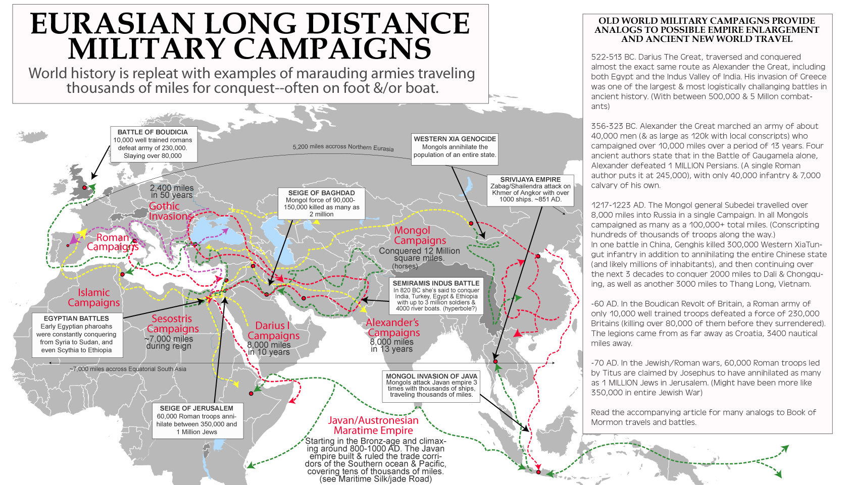
SUMMARY OF WHY BOOK OF MORMON DIRECTIONS DO NOT MATCH MAYANLAND MODELS
– THE ‘NEPHITE NORTH’ CONCEPT IS ABOSULTELY DESTROYED BY 1 NEPHI 16 & 17, AS WELL AS ISAIAH PASSAGES AND ALLUSIONS TO BIBLICAL DIRECTIONALITY PHRASES MADE BY CHRIST HIMSELF.
Mayanland models suffer from irreconcilable directionality issues, which they often attempt to resolve with a concept known as ‘Nephite north’ where the BOM directional system is rotated by 90 degrees. Without the rotation, scriptures like Haggoth’s journey to the Land Northward from the West Sea (Alma 63:5–9) becomes more of a journey to the land Westward from the South Sea. Or worse in Alma 50:7–14, the ‘east wilderness’ (v.7) become a north wilderness, the “lands which were south of the land of Zarahemla” become north of the land of Zarahemla, and the “city Moroni… by the east sea… south by the line of the possessions of the Lamanites” becomes by the north sea, north by the possessions of the Lamanites. In fact most of Alma 22 become twisted directionally as well. To overcome these and other direction issues the unworkable Nephite north was proposed. Which might prove logical were it not that 1 Nephi 16:13–14 & 1 Nephi 17:1 show it to be untrue.
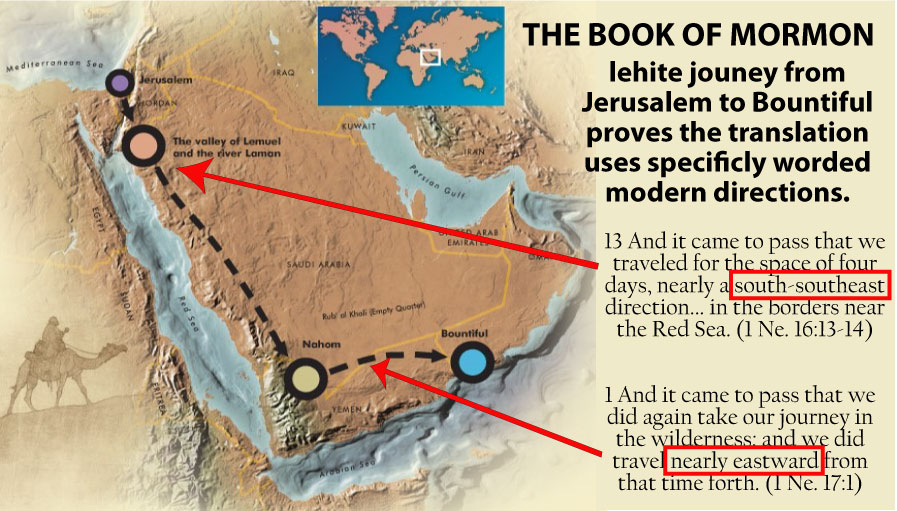
To understand Sorenson’s logic concerning ‘Nephite North’, a reader should first consult the article Directions in Hebrew, Egyptian, and Nephite Language, by William Hamblin and reproduced in Sorenson’s Geography of Book of Moron Events, appendix C. In this article, Sorenson & Hamblin rightly point out that Egyptian and Hebrew coordinate systems were often rotated by 90 degrees. This because during some periods Egyptians seem to have oriented themselves by the headwaters of the Nile, and Israelites by the rising sun. Thus “One of the terms for ‘south’ [in Egyptian] is also a term for ‘face’; the usual word for ‘north’ is probably related to a word which means the ‘back of the head.’” (see Turin Papyrus Map or demotic magical papyrus). In fact as Hebrew scholar David Ben-Gad HaCohen points out in Ancient mapping: Israelite vs Egyptian Orientation, he agrees with the initial parameters of Sorenson/Hamblin’s presumed logic saying,
…the Egyptian term for south was “face” or “upstream.” [And] “Back,” “downstream,” or “end,” was the term for north. With this orientation towards the south, right and left referred to west and east respectively. In fact, the Egyptian term for “right” is actually cognate [or root form] with the Hebrew term [for right], (ỉmnt in Egyptian, ymn in Hebrew), although in Egyptian it referred to the west [whereas in Hebrew it refers to the south].
Importantly, is reiterated in Brant Gardners defense of Sorenson & Hamblins “Nephite North” argument that the Maya, like the Hebrews, incorporated the concept, k’in ‘sun’, into the term east (lak’in), and also used the concepts left and right for north and south respectively.
So in Hebrew the term ‘face’ meant east, and in Egyptian it meant south. And in Hebrew (and possibly Maya) the term right meant south, and in Egyptian it meant west. But following this logic shows that if Mormon was using his native Hebrew logic of face=east and right=south, then when writing his logic into the Reformed Egyptian language of the plates (without properly translating true directions according to the obvious sun rises in east sets in west as Sorenson/Hamblin suggest) he would have accidentally used Egyptian words that Joseph Smith literally translated from Egyptian as face=south and right=west respectively. This logic seems plausible because the land to the east of Zarahemla would be have actually been called the land faceward (land eastward), which Joseph then might have wrongly translated, the land southward (after the Egyptian convention instead of the Hebrew).

Lets explain that one more time just to make sure everyone understands the logic (which as I’ll explain, 1 Ne. 16:13, & 1 Ne. 17:1 destroys) In Hebrew the term ‘sea south’ would be קרקע דרומה or land yamín/ymn or more literally ‘sea of the right hand’. (see strongs 3227) So if Mormon didn’t correctly translate his meaning of true south, or right of the rising sun, into Egyptian, he might have written in reformed Egyptian something like ‘sea ỉmnt’ or sea of the right hand. Which, as the Sorenson argument goes, as Joseph Smith translated by the power of God, got translated literally instead of translating its true meaning, and thus ‘sea south’ would become ‘sea west’, since the Egyptian word for right (which shares a root with the hebrew word for right) translates to west.
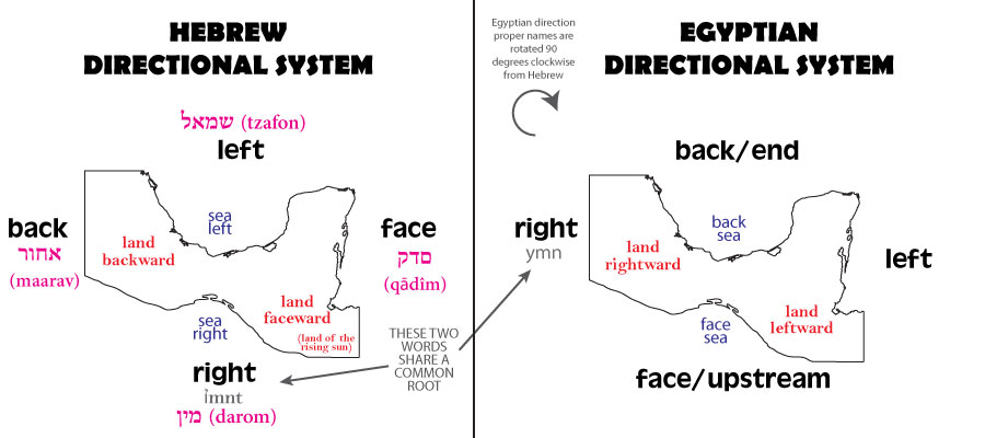
Now that we understand the logic, and you’ve been thoroughly baffled with BS, let me explain why this theory is absolutely untenable.
0. THERE ARE ZERO EXAMPLES OF HEBREW OR EGYPTIAN TRANSLATIONS WHO CONFUSE DIRECTIONS BY 90 DEGREES. So although the above logic is sound, even poor translators correctly translated the ancient directions to modern directions. And Sorenson wants you to believe the BOM translators FAILED where all others succeeded.
1. The correct directionally given in 1 Ne. 16:13, & 1 Ne. 17:1 show clearly that Mormon did not incorrectly project his Hebrew directionality into the text. The Lehites journey “south-southeast” along the red sea make this clear. And should anyone suspect Joseph ‘corrected’ Mormon’s incorrect directions, 1 Ne. 17:1 proves he didn’t, as Joseph would not have known about heading east to Nehom or the only spot in Yemen with trees to build ships! Likewise 2 Nephi 21:14 usage of the biblical/traditional ‘west’ shows there was no translation/cultural directional mistakes. And Christ’s words in 3 Nephi 20:13 also follow the bible verbiage using east/west then north/south in an obvious allusion to Psalm 107:3 and Isaiah 43:5–6 showing again that east and west are being translated correctly! (In fact Egyptian influence may be present here, causing north & south to be reversed but not north/south and east/west!) Several other Isaiah passages also show Mormon correctly passed on Hebrew directions to Joseph (see 1 Ne 21:13, 2 Ne 12:6)
2. The idea that Mormon got his directions wrong doesn’t hold weight when we consider the number of times north & south are associated with “lands” (Hel 3,7; Alma 46,52, 63,50,22; Mormon 2, etc) contrasted with the number of times east & west are associated with “seas”. Surely Mormon would understand from the context if he was mismatching sea and land! And surely Joseph would catch this mistake it it was somehow made on his part!
3. In fact the imagery of 3 Nephi 1:17 make the idea of mistaken directions impossibly ridiculous. In this verse the phrase “17 And they began to know that the Son of God must shortly appear; yea, in fine, all the people upon the face of the whole earth from the west to the east, both in the land north and in the land south, were so exceedingly astonished that they fell to the earth.” obviously has reference to the rising and setting of the sun. It’s honestly crazy to think that this verse should actually have a 90 rotation applied and say anything different than what it says. The same type of terminology is used in the Turin Papyrus Map and no one has or would translate that reference incorrectly because of its relationship to the sun!
4. Also, like old world texts, the Book of Mormon tends to use the same type of language employed in describing the motion of the sun, when talking about east/west directions related to the sun. “8 And the land of Nephi did run in a straight course from the east sea to the west.” Alma 50:8, Also Alma 22 “the river Sidon, running from the east towards the west”. This is likely because the words themselves in both Hebrew & Egyptian were related with concepts (such east and the rising of the sun) making confusion incredibly unlikely! For instance, the Hebrew word for east ‘miz-rāḥ‘ meant ‘rising’. The Hebrew word for west ma-‘ă-rāḇ, meant ‘sunset’. Also the word for north ṣā-p̄ō-wn, meant ‘hidden. Its only the Hebrew word for south yām or ṯê-mān, which kept its Egyptian meaning of ‘sea’ (as in the Mediterranean Sea) and thus came to mean or be translated as right hand, south or west. (Genesis 1:10 translates it as ‘sea’, Genesis 12:8 translates it as ‘west’).
–
Critique of the Sorenson Model (& all others which put all B.O.M. ‘east coast cities’ on the north coast of Tehuantepec)
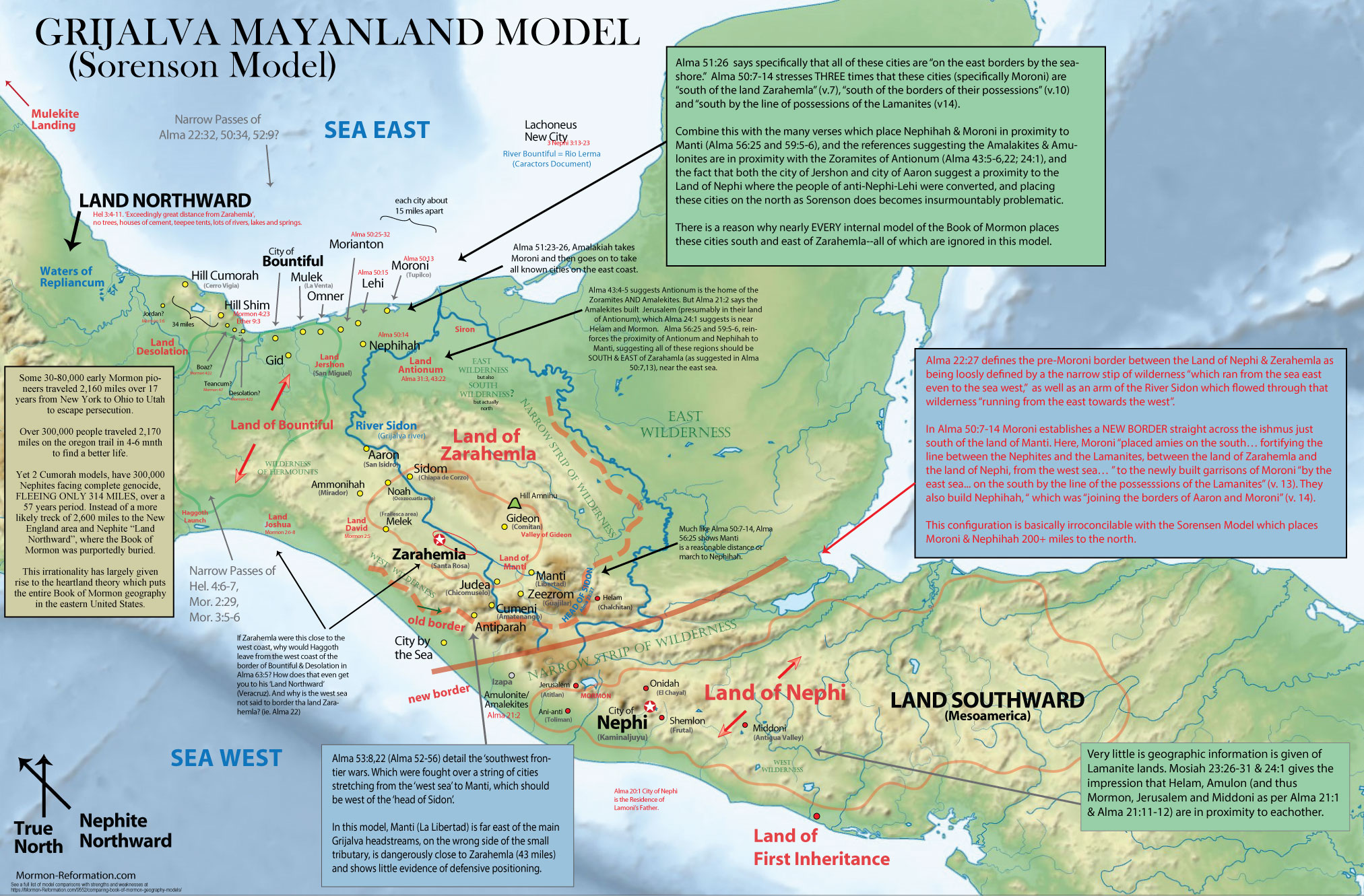
The Sorenson-Grijalva model prioritizes archaeology correlations over geography relationships, so it has more issues with correlating the placement & populations of its cities with what’s implied in the Book of Mormon text but is superior to the Usumacinta models in its archaeological correlations. In this section we focus on a number of geographic issues the model has with the text.
– NEPHITE NORTH. We already spoke of the issues Mayanland models have with general directions in the BOM text. So in this section we will accept, and attempt to use the 90 degree rotation needed to make directions generally fit the text. However, at the end of this section we will show that “Nephite north” or the theory proposed by Sorenson that Egyptian/Hebrew directions were rotated by 90 degrees is not supported by archaeology or the bible.
– POPULATIONS DONT MATCH WELL. Sorenson’s match for the city of Zarahemla is an archaeological site called Santa Rosa in the Grijalva Valley. The site was drown beneath the La Angostura Reservoir in 1974 but before this a detailed archaeological analysis was made. This study puts the maximum population of the site at less than 20,000 people. Both its number of mounds, artifacts & other population indicators suggested it was a satellite city to the larger, more prominent nearby site Chiapa de Corzo. However, Chiapa de Corzo being far to the ‘nephite north-west’ does not match any sites mentioned in the BOM text (so Sorenson attaches it to Sidom). Much like the Heartland’s Zarahemla, this population setup just does not match with the Book of Mormon. When Nephi sees our day, he describes the latter-day population of the promised land as “in number as many as the sand of the sea.” This same phrase is used in Mormon 1, where Mormon describes visiting the land of Zarahemla where,
7 The whole face of the land had become covered with buildings, and the people were as numerous almost, as it were the sand of the sea. (mormon 1:7)
The same description is given to the combined forces of the Lamanites, Amlicites after a small preliminary battle caused 12,532 + 6,562 casualties and after which the dead “were so numerous that they could not be numbered” (Alma 2:19,27,35). The same is said in Moroni’s battles of Alma 51:27 where Mormon describes Amalickiah’s army as “a numberless host”. This is juxtaposed with battles consisting of the “many thousands” of Alma 51:11, 30,000 of Mormon 1:11, 44,000 of Mormon 2:9, and 50,000 of Mormon 2:25 (not to mention the 250,000 number of dead given in Mormon 6.
Even before the time of Christ after Moroni’s wars when Lachoneas urbanizes the people by the “many thousands” into the center of the border of Zarahemla & Bountiful (3 Ne 3:23–26) we learn of many military skirmishes which suggest enormous numbers in the population. In battle against the gorilla forces of the Gadianton Robbers it says,
21 And the Nephites were continually marching out by day and by night, and falling upon their armies, and cutting them off by thousands and by tens of thousands. (3 Nephi 4:21)
If the Gadianton robbers had multiple battles where they lost not just thousands but “tens of thousands” of soldiers in multiple battles not even worth specific mention, then we can infer that the Nephite capital area was hosting populations at least in the hundred thousand range! Thus picking an archaeological correlation for Zarahemla that was as small and inconsequential as Santa Rosa seems less convincing when better options are available.
It’s no wonder that renowned non-Mormon archaeologist Michael Coe explained that the only culture that could fit the type of numbers given in the Book of Mormon is the Mexican Highland.
– ALMA 52:9 MAKES NO SENSE WITH THIS MODEL. The location of all the east cities AND Bountiful in Sorenson’s model makes it so Alma 52:9 makes no sense because it is SOO far ‘north’ (even though its actually west) of the land of Zarahemla, that guarding the ‘pass’ near bountiful makes absolutely no strategic bearing on the security of the Land of Zarahemla. Listen to the wording of the verse.
9 And he also sent orders unto him that [Teancum] should fortify the land Bountiful, and secure the narrow pass which led into the land northward, lest the Lamanites should obtain that point and should have power to harass them on every side. (Alma 52:9)
Look at the map and note that NONE of Sorenson’s ‘east coast’ cities would keep the Lamanites out of Zarahemla. Only a configuration as discussed in #1 would. Alma 60:19 further pushes this issue that Moroni’s defensive cities spoken of in Alma 51-59 fully protect the central land of Zarahemla.
19 Or is it that ye have neglected us because ye are in the heart of our country and ye are surrounded by security, that ye do not cause food to be sent unto us, and also men to strengthen our armies? (Alma 60:19)
– EAST COAST CITIES ARE NORTH OF ZARAHEMLA INSTEAD OF EAST. Note particularly Alma 51:26’s language where it says,
Nephihah, and the city of Lehi, and the city of Morianton, and the city of Omner, and the city of Gid, and the city of Mulek, all of which were on the east borders [of Nephite lands/land of Zarahemla-per Alma 50:13–15] by the seashore. (Alma 51:26)
Note it does not say “on the east seashore”, but “on the east borders.” And from Alma 52:9 mentioned above, we can again confidently assume that’s referring to the east borders of the Land of Zarahemla. And Alma 50:13 makes this more clear, specifying that Nephihah is on the “south” of the east sea (as we’ll go over in a moment), where as the Lehi, Morianton, Omer, Gid & Mulek are a bit farther north, but still obviously in line enough with the Land of Zarahemla to make all the evidence fit.
How can these cities be considered to be “on the east borders” of Nephite lands in Sorensen’s model when he has them so far North? They are LITERALLY WEST of Zarahaemla— But even using Sorensen’s 90 degree rotation of “Nephite North”, placing these cities on Tehuantepec in line with Bountiful clearly makes them northern border cities contrary to the text & flow of the Lamanite attack. Not to mention that such a configuration leaves the entirety of the western flank of the land of Zarahemla or Chiapas depression open for attack (discussed next). It also makes the location of Jershon illogical (discussed later).
– SORENSON’S PLACEMENT OF NEPHIHAH, MORONI & MANTI ARE ILLOGICAL & CONTRARY TO THE TEXT. Alma 50 puts the nail in the coffin concerning the above issues, showing the problem in all Mayanland models but especially the Sorenson model. Alma 50:7–15 begins by saying Moroni DROVE THE LAMANITES OUT OF THE EAST WILDERNESS until they were SOUTH OF ZARAHEMLA, and then created a new border which runs IN A STRAIGHT COURSE FROM THE EAST TO THE WEST SEA. Look at the map and try and figure out how this works with Sorenson’s model? It doesn’t!
The text then says he “placed armies on the SOUTH…[of the east wilderness and land of Zarahemla–as per v.7-8] fortifying the line between the Nephites and the Lamanites, between the land of Zarahemla and the land of Nephi, from the west sea…” to the newly built garrison cities of Moroni, which was “by the east sea… on the south” by the line of [Lamanite] possessions” by the new border (v. 13). And Nephihah, Aaron & Moroni all share borders (v. 14).
This absolutely does not work with Sorenson’s model. Read the whole section here carefully for yourself. Mormon first specifies the “straight course” (east/west sea to sea) nature of the border, then says the city of Moroni is built right on it— SOUTH of Zarahemla.
7 And it came to pass that Moroni caused that his armies should go forth into the east wilderness; yea, and they went forth and drove all the Lamanites who were in the east wilderness into their own lands, WHICH WERE SOUTH OF THE LAND OF ZARAHEMLA. 8 And the land of Nephi did run in a straight course from the east sea to the west. (Alma 50:7–8)
10 And he also placed armies on the south [of the Land Zarahemla & east wilderness], in the borders of [Nephite] possessions… 11 And thus he cut off all the strongholds of the Lamanites in the east wilderness, yea, and also on the west, fortifying the line [of possession] between the Nephites and the Lamanites, between the land of Zarahemla and the land of Nephi, from the west sea, running by the head of the river Sidon–[to the east sea, per verse 8] 13 And it came to pass that the Nephites began the foundation of a city, and they called the name of the city Moroni; and it was by the east sea; and it was ON THE SOUTH by the line of the possessions of the Lamanites. 14 And they also began a foundation for a city between the city of Moroni and the city of Aaron, joining the borders of Aaron and Moroni; and they called the name of the city, or the land, Nephihah. 15 And they also began in that same year to build many cities on the north, one… called Lehi. (Alma 50:10–15)
These verses are SO descriptive, that essentially ALL internal models interpret a similar layout of a backwards L of border cities. Note specifically that Moroni & Nephihah ARE ON THE SOUTH right on the Nephite/Lamanite border, as opposed to Lehi & its neighbors which are ON THE NORTH– but not SO far north that Alma 52:9 doesn’t make sense. So Sorenson’s placement directly contradicts the text! But even if we use stretches of logic to twist the text to say something different—if Moroni & Nephihah (which are part of the East Coast Cities mentioned in Alma 51:26) were on the North coast of Tehuantepec, how does that help divide or fortify Zarahemla from Lamanite attack from the land of Nephi?! How can they be considered “south of the Land of Zarahemla” (Alma 50:7) or “south of the borders of their possessions” (Alma 50:10) or “south by the line of the possessions of the Lamanites” (Alma 50:13)! Especially when the context seems to infer that all of these terms are referring to the same area.
– MANTI IS IN PROXIMITY TO NEPHIHAH & MORONI IN THE TEXT. (As per Alma 56:25, Alma 59:5–7, Alma 43:22) Putting Manti far from Nephihah or Moroni is fully against the text. (A full 200-250 miles in Sorenson’s Model.) In these three verses, armies move between these cities as if they are the closest options. For instance the Lamanite armies guarding Manti debate whether to retreat to Nephihah when under attack from Helaman’s forces.
25 Neither durst they [the Lamanites in Manti & surrounding cities] march down against the city of Zarahemla; neither durst they cross the head of Sidon, over to the city of Nephihah. (Alma 56:25)
Later after Helaman and the 2000 stripling warrior drive them from the city of Manti & Judea, the Lamanite armies flee there anyway. Obviously because Nephihah was one of the closest cities needing reinforcements.
5 And it came to pass that while Moroni was thus making preparations to go against the Lamanites to battle, behold, the people of Nephihah, who were gathered together from the city of Moroni and the city of Lehi and the city of Morianton, were attacked by the Lamanites. 6 Yea, even those who had been compelled to flee from the land of Manti, and from the land round about, had come over and joined the Lamanites in this [Nephihah] part of the land. 7 And thus being exceedingly numerous, yea, and receiving strength from day to day, by the command of Ammoron they came forth against the people of Nephihah… (Alma 59:5–7)
Remember Nephihah was between Aaron and Moroni (Alma 50:14), and Aaron was somewhat near Ammonihah (Alma 8:13). And Moroni, Nephihah and Lehi are all relatively close by each other (Alma 51:24–26). It makes ABSOLTELY no sense for the people of Manti near Libertad on the Chiapas border to flee over 200 miles to Sorenson’s Nephihah on the north reaches of the Grijalva River near the coast.
– SORENSON’S ANTIONUM DOESN’T WORK WITH THE TEXT. The Book of Mormon strongly implies that Antionum is south-east of the land Zarahemla. Sorenson’s model puts it northwest (or north-northeast using “Nephite North”). Read the references and note how Sorenson’s configuration would require the west Yucatan to be the “wilderness south” of Alma 31:3, which makes absolutely no sense–because that region is already his east wilderness.
3 Now the Zoramites had gathered themselves together in a land which they called Antionum, which was east of the land of Zarahemla, which lay nearly bordering upon the seashore, which was south of the land of Jershon, which also bordered upon the wilderness south, which wilderness was full of the Lamanites. (Alma 31:3)
The South Wilderness is defined elsewhere, and it is not East! Alma 16:7 puts it south of Zarahemla, “up beyond the borders of Manti”, near the head of the River Sidon. Alma 22:27–31 agrees, saying the Land of Zarahemla and the Land of Nephi are separated by a “narrow strip of wilderness” (v.27), which we have no reason not to believe is the “south wilderness” of v.31
– ANTIONUM IS ASSOCIATED WITH THE AMALEKITES & THEIR CAPITAL JERUSALEM WHICH SHOULD BE IN PROXIMITY TO JERSON, HELEM, MORMON & THE EAST SEA Alma 43:4–6,13–15 suggests Antionum is a major base of the Amulonites, Zoramites AND Amalekites. But Alma 21:1–2 says the Amalekites built Jerusalem (presumably in their land of Antionum!), which Alma 24:1 suggests in near Helam and Mormon. Alma 56:25 and Alma 59:5–6 reinforces the proximity of Ationum and Nephihah to Manti, suggesting all these regions should be SOUTH and EAST of Zarahemla (as suggested in Alma 50:7,13–14), near the east sea.
– ANTIONUM IS NEAR MANTI. Once again, Alma 31:3 says Antionum is EAST of Zarahemla & south of Jershon. But Alma 43:22 implies that Antionum is at least a bit SOUTH-EAST of Zarahemla near the southern border between the Nephites and Lamanites. Why else would the Zoramite/Amalekite army come into Manti after trying to attack Jershon? In Sorenson’s model this army would have marched over 300 miles to get from Jershon on Tehuantepec to Manti in the Grijalva basin! Not only does this not make sense distance wise.. it also makes little sense strategically.
22 Behold, now it came to pass that they durst not come against the Nephites in the borders of Jershon; therefore they departed out of the land of Antionum into the wilderness, and took their journey round about in the wilderness, away by the head of the river Sidon, that they might come into the land of Manti and take possession of the land; for they did not suppose that the armies of Moroni would know whither they had gone. (Alma 43:22)
– JERSHON DOESN’T WORK WITH SORENSON’S MODEL EITHER! Note that the above verse also makes Sorenson’s location of Jershon CONTRARY TO THE TEXT. In fact Jershon breaks the Sorenson model, because as we just read, Jerson is north of Antionum. And Antionum is EAST of Zarahemla (Alma 31:3). In fact its southeast, not northeast which we’ll prove in a moment. Yet Sorenson is FORCED to put Jershon and Antionum to the North of Zarahemla because his city of Bountiful is SO FAR NORTH, and Alma 27:22 clearly states that Jerson borders Bountiful.
22 And it came to pass that the voice of the people came, saying: Behold, we will give up the land of Jershon, which is on the east by the sea, which joins the land Bountiful, which is on the south of the land Bountiful (Alma 27:22)
Alma 27 also goes on to imply that Jerson is near, and possibly even borders, the land of Nephi
23 And behold, we will set our armies between the land Jershon and the land Nephi, that we may protect our brethren in the land Jershon (Alma 27:23)
So Jerson borders Bountiful AND Antionum, which is EAST (Alma 31:3) and NOT NORTH or north-east of Zarahemla as he tries to make it. Honestly this should also be clear from the fact that Manti (Alma 43:22) is the first city attacked by Zerahemnah who stages his war from Antionum (Alma 43:5,15), which is obviously located somewhat near the south border (which is why the Nephites were worried about a possible separatist movement among them in Alma 31:4).
In fact the wording of Alma 28:1–3 suggests that Jershon would be somewhat near the southern border on the borders of Zarahemla and the “south wilderness” close to Nephi. Especially when you add how the people of Jershon are later moved to a safer location (Alma 35:13)? Jershon & Antionum being on the southern border by the land Nephi is also suggested by Alma 43:22 which has the Amalekites heading over to Manti and the head of Sidon as the next best attack point after being scared off in the land of Jershon. In Sorensen’s model this would be a 250 mile flank maneuver across an enigmatic massive swath of eastern frontier which his model has no cities guarding!
22 Behold, now it came to pass that [the Amackites] durst not come against the Nephites in the borders of Jershon; therefore they departed out of the land of Antionum into the wilderness, and took their journey [way, way, way?] round about in the wilderness, away by the head of the river Sidon, that they might come into the land of Manti and take possession of the land (Alma 43:22)
The close relationship between these regions is also suggested in Alma 59:5–7 where Nephihah and Moroni receive reinforcements from the Manti area.
– MORONI (AND THUS NEPHIHAH & JERSHON) ARE IN THE CORNER OF THE WILDERNESS SOUTH & WILDERNESS EAST. We’ve already established this in previous verses, but Alma 62 hits it home by stating that the land of Moroni is surrounded by the wilderness south and wilderness east.
34 And it came to pass that Moroni and Lehi and Teancum did encamp with their armies round about in the borders of the land of Moroni, insomuch that the Lamanites were encircled about in the borders by the wilderness on the south, and in the borders by the wilderness on the east [of the land Moroni]. (Alma 62:34)
Remember that Moroni is right on the east sea which drowns it at the death of Christ (3 Ne 8:9), so the “wilderness on the east” is obviously talking about the “east wilderness” which is east of the land of Zarahemla & Nephi (Alma 50:7–11, Alma 25:5), not a wilderness east of Moroni (since there’s a sea east of Moroni). Because of this we can safely assume that the “wilderness on the south” is also in relation to the Land of Zarahemla, or in other words, the “south wilderness” or narrow strip of wilderness that lies between the Nephite and Lamanite lands (as explained in Alma 16:6). This configuration is nowhere close to what Sorenson proposes. Sorenson’s model has Moroni nowhere EVEN NEAR the south wilderness. Or ANY south wilderness for that matter.
– AMMONIHAH’S LOCATION IS ILLOGICAL. Furthermore his northern location of Ammonihah, Noah and Aaron make no logistical sense. The Lamanite retreat of Alma 16 has an army crossing the head of Sidon while taking the captives home to the Land of Nephi. In Sorensen’s model, this would put the army retreating literally 200 miles directly through the south end of the Land of Zarahemla, in order to put them at the head of Sidon (La Libertad in his model), which makes absolutely no sense given the context of the story. In fact, Alma 49:3,15 says that Ammonihah was twice a target of Lamanite aggression because it was an “easy prey” or convenient point of attack. So would a city 250 miles into enemy territory really be considered an “easy target? Doesn’t a placement much closer to the Nephite/Lamanite south border make far more sense?
Especially, since we know Ammonihah is near Aaron (Alma 8:13), Jershon (Alma 35:1–8) and the Land of Antionum, then Alma 49 is the SECOND time an army heads toward Manti from that area. So once again it is completely illogical to not place these two areas adjacent or somewhat close to one another along a southern border as suggested by most internal models as well as suggested by Alma 31:3 & Alma 50:7.
– ZERAHEMLA IS NOT LIKELY VERY NEAR THE WEST COAST. The Book of Mormon does not seem to indicate that Zarahemla is near the West Sea or Coast. In fact if anything, it suggests its closer to the east coast. Note that the ‘new border’ cities and war chapters of Alma 51-58 talk about defensive cities on the southern border and EASTERN border, more likely suggesting that Zarahemla is closer to the east coast than the west coast, and that the “west wilderness” (Alma 8:3, Alma 2:37) must be a major obstacle protecting the land from western entrance or exit.
More importantly, the Land of Zarahemla is NOT said to stretch “from the east sea unto the west sea” in Alma 22:27,33 like the land of Nephi, narrow strip of wilderness and land of Bountiful are. Additionally Helaman 1:18, 24–27 calls Zarahemla “the center of the land” and Alma 60:19 has Moroni calling the land of Zarahemla “in the heart of our country surrounded by security”. Sorenson’s model has Zarahemla being less than 50 miles from the west coast, which is hardly the heart of region.
—
Critique of the Usumacinta Mayanland Models
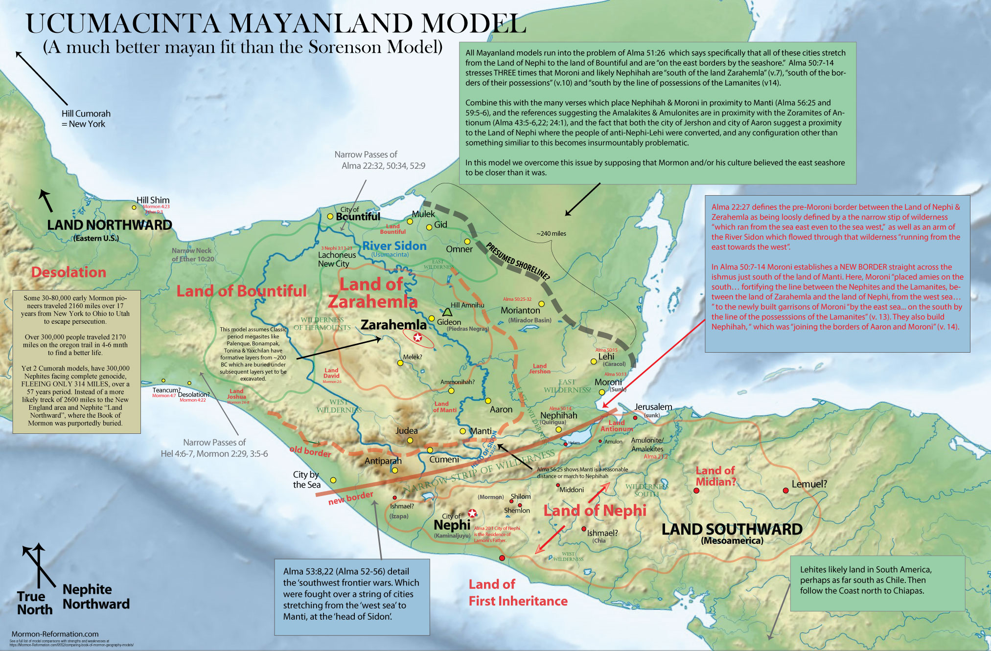
The Usumacinta model prioritizes the geographic relationships between east coast cities (especially Moroni & Nephihah) over archaeologic correlations (especially in the known dates of cities) and thus seems to do a slightly better job at fitting its geography to the Book of Mormon text than the Sorenson/Grijalva Model (or any model which places the ‘east sea’ cities on the north coast of Tehuantepec). However, like all Mayanland models, it still shares a few major issues with the ‘east sea’ cities. A problem which seems to be best overcome by supposing that Mormon and/or his people believed the east sea to be closer to Zarahemla than it was. (ie. the Yucatan peninsula was not as big as it actually is).
– Usumacinta models do a very poor job of matching formative archaeological sites to the Book of Mormon text. Although after the Time of Christ, archeological sites like Palenque, Tonina, Bonampak or even Yaxchilan could make for excellent correlations with Zarahemla with their large classic era populations, temples building and known trade networks and city-state formation—NONE of these sites match the timeline of the Book of Mormon well. The Book of Mormon suggests Zarahemla should have been founded by Mulekites sometime around 600 BC, but then see a burst of growth and city-state creation when Mosiah I come with his group from the Land of Nephi and consolidates power. And even more particularly when Captain Moroni re-aligns the border and consolidates power. With a slight population decline at the Time of Christ’s death from volcanic episodes and a massive resurgance from 33-350 AD when a collapse should appear.
Unfortunately none of these events are really seen in the archaeology with the exception of a political dispute in Tikal around 350 AD. (and Tikal is EAST of the Usumacinta (Sidon) which is contrary to the text.
– The Mirador Basin’s major formative population centers are very problematic for Usumacinta models. (Explain this when you have time. Mirador Basin sites DWARF every other preclassic city of the Usumacinta region, including Kaminaljuyu, and yet it exists in a region in the model where ZERO cities are mentioned. As a Nephite city, it would have dwarfed the population of their entire LAND of Zarahemla, and as a Lamanite city it would have dwarfed their entire LAND of Nephi in Kaminaljuyu. So then why doesn’t the Book of Mormon mention that region as a city or even land in this model? If they are Lamanites, then it makes no sense where Moroni pushes the Lamanites south of his new Border in Alma 50. And certainly makes no sense in terms of Alma 51)
– Land Northward & Southward are still east and west. Especially considering that directions are going to have been relative to Zarahemla (or at least Desolation where Mormon was from). In this model, Desolation and the Land of Many Waters in the Land Northward are literally DUE WEST, not even remotely close to ‘northward’.
– The Land Bountiful becomes VERY confusing. Especially the way Kirk Magleby draws it. Where it stretches from the Sea North-East to the Sea North-West to the Sea South-west? Maybe that works, but when comparing it to the similiar ‘East Sea to West Sea’ descriptions of the Land of Nephi, Zarahemla and Narrow Strip of Wilderness named in Alma 22, it just becomes a really awkward fit with the text. See Magleby’s model here.
– South Veracruz as the Land of Many Waters makes incredibly little sense for a people living in the Usumacinta lowlands. The swamps of the same region and those of adjacent Tabasco have just as “many waters, rivers, and fountains” (Mormon 6:4) as those to the North, making the distinction seem a bit silly and unwarrented.
Strengths and weakness are covered in the Mayanland model section above.
PLUS ALL THE OTHER ISSUES ARLEADY MENTIONED ABOVE CONCERNING ALL LIMITED MESOAMERICAN MODELS
Usumacinta Rio Pasion Model
Strengths
The Rio Pasion model recognizes the weaknesses of having to rotate Mesoamerican maps 90 degrees to make them work, as well as the lack of matching Zarahemla with a notable archaeological site with considerable population, as well as the weakness of the width of Teohuantepec compared to the day or day and a half’s thickness of the narrow passes. It attempts to overcome these weaknesses by making the Land Northward, the northern Yucatan.
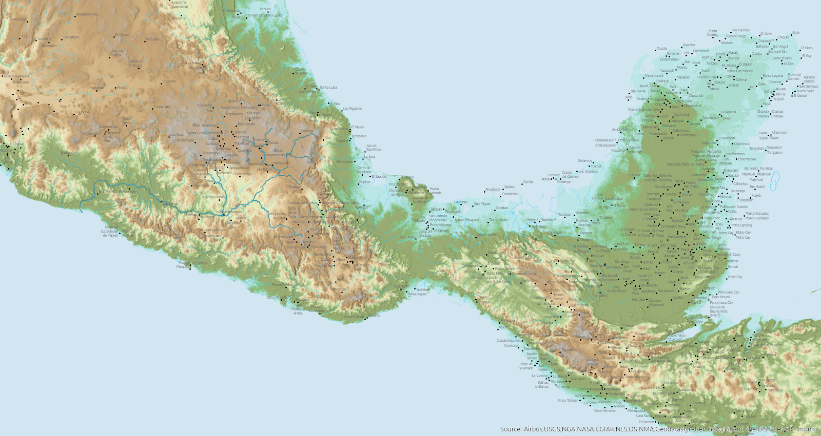
Weaknesses
-The narrow neck assumes an unproven shoreline change, that’s hard to make work. As you can see in the illustration above, if you increase sea level either globally or ecstatically (locally) before the time of Christ, you flood a LOT of archaoelogical sites that are known to date before the time of Christ. In fact, the sea simply would not come in and form a perfect ‘narrow neck as they propose. Although it does come in on the west side, it would not on the west side.
-The land northward experience MORE destructions. (how does that make sense in the Northern Yucatan)
-The Land Northward has many lakes, rivers and streams. The North Yucatan is almost devoid of these things because of its karst geology.
-The Land Northward is where the final destruction happens… where is Cumorah?
-If you hold to the Tikal rebellion, then how is Teotihuacan the Lamanites & Gadiatons that were given the land southward?
-Im guessing the Mirador Basin is Desolation where the Jaredites were destroyed… but how was it devoid of timber? If burned it would grow back within a single generation. And how did the swords last in such a humid environment?
–
Brian Nettles ‘BookofMormonHeartland.com’ Model
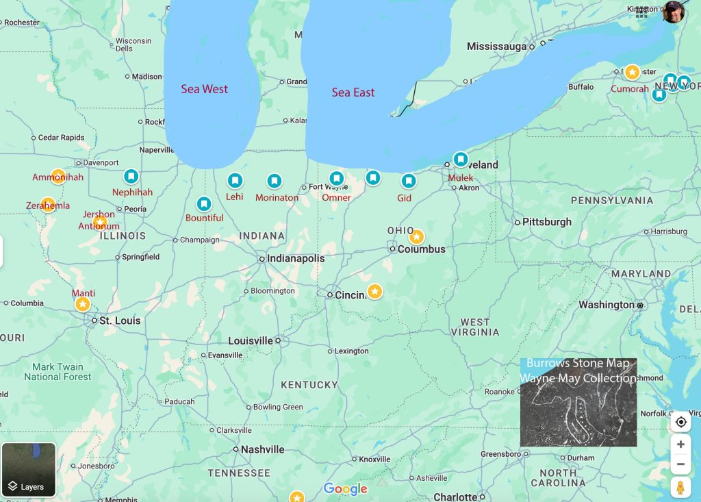
Issues
Chapter 22 is clear….
The Land of Nephi’s borders stretched from sea to sea (the east sea to west sea)
–“the king sent a proclamation throughout all the land, amongst all his people who were in all his land, who were in all the regions round about, which [Land of Nephi] was bordering even to the sea, on the east and ON THE WEST…” (Alma 22:27)
The borders of the Land of Nephi & Land of Zarahemla were separated by a narrow strip of wilderness which also ran from sea to sea (the east sea to west sea)
–“which [Land of Nephi] was divided from the land of Zarahemla by a narrow strip of wilderness, which ran from the sea east EVEN TO THE SEA WEST…” (Alma 22:27)
The land of Bountiful, which “the Nephites had inhabited”, was north of Zarahemla and also stretched “even from the east unto the west sea”
–“the Nephites had taken possession of all the northern parts of the land bordering…on the north, even until they came to the land which they called Bountiful… And it came to pass that the Nephites had inhabited the land Bountiful, even from the east UNTO THE WEST SEA…” (Alma 22:29–33).
There is a seashore west of BOTH the Land of Zarahemla AND the Land of Nephi, which is near the Lehite Land of First Inheritance.
–“they were spread through the wilderness on the west, in the land of Nephi; yea, and also on the west of the land of Zarahemla, in the borders by the seashore, and ON THE WEST in the land of Nephi, in the place of their fathers’ first inheritance, and thus bordering along by the [WEST] seashore.” (Alma 22:28)
The east and west seas are also mentioned in at least a half dozen other verses. Especially in regard to the Lamanite attacks on the Nephite southwest border. (see Alma 52:11–12, Alma 53:8, Alma 53:22, Alma 56:31, compare Alma 22:28)
–“8 And now it came to pass that the armies of the Lamanites, on the west sea, south, while in the absence of Moroni… had gained some ground over the Nephites, yea, insomuch that they had obtained possession of a number of their cities in that part of the land. (Alma 53:8)
11 And he also said unto him, I would come unto you, but behold, the Lamanites are upon us in the borders of the land BY THE WEST SEA; (Alma 52:11–12)
31 And we were to march near the city of Antiparah… in the borders by the [west] seashore. (Alma 56:31)
26 And thus he went on, taking possession of many cities, the city of Nephihah, and the city of Lehi, and the city of Morianton, and the city of Omner, and the city of Gid, and the city of Mulek, all of which were on the east borders by the [east] seashore.” (Alma 51:24–26)
And there’s other serious issues with his model, which he should revisit. (And I mean serious conflicts with the text… there’s a reason why all the major internal models in the church mostly look alike!) 1. For instance read Alma 50! It destroys the entire logic of this East Sea cities placement. (Which is probably why he’s added none of the cities on there which Moroni built to defend the border between the two lands.) Lets look at it. “10 And [Moroni] also placed armies on the south [of the land of Zarahemla], in the borders of their possessions, and caused them to erect fortifications that they might secure… their people… 11 …fortifying the line between the Nephites and the Lamanites, between the land of Zarahemla and the land of Nephi, from the west sea, running by the head of the river Sidon— 13 …[to the] foundation of a city, and they called… Moroni; and it was by the east sea. (Alma 50:8–13, esp. verse 11). So he builds a line of cities between the Land of Zarahemla & Nephi from East Sea to West Sea. Why? Read the chapter… its to fortify the line between the Lands of Zarahemla and Nephi. Your placement makes that impossible! And what are the cities he builds and/or fortifies? We read of them in Alma 50-60. A city by the West Sea (Alma 53:22; Alma 56:31), then moving TOWARD Nephihah & Moroni the cities of Antiparah, Cumeni, Zeezrom and Manti. Those defensive cities are taken by armies IN THAT ORDER. Moving from west to east. (see Alma 53:8,22, 56:14) So those are the cities Moroni built to guard the SOUTH border on the West. (Alma 53:8) On the other side of this southern border are the cities of the East Sea spoken of in Alma 50 & 51. Namely Moroni & Nephihah. And manti, once taken is in proximity to Nephihah (Alma 56:25)! And Nephihah and Moroni are ON THE EAST SEA (Alma 50:14).
Now its crazy important to realize Nephihah and Moroni are on the “south by the line of possession of the Lamanites” (Alma 50:13). South of what? South of Zarahemla of course! Which is why after taking Nephihah and Moroni, Amalickiah goes on to “take Nephihah, Lehi, Morianton, Omner, Gid and Mulek, all of which were east on the borders of the seashore” (Alma 51:26), suggesting that those cities were arranged in that order from south to north along the east sea. They then “march forth… that they might take possession of the land Bountiful and also the land northward” (Alma 51:30). HOW DOES THAT MAKE ANY SENSE IN THIS MODEL? Where even is your land Northward? Wisconsin? Michagan? Neither works! You have the Lamanites marching right toward Zarahemla instad of “the land Bountiful and also the land northward” (Alma 51:30).
And how does that work with Alma 56:25 which strongly implies that the closest major cities to Manti are Zarahemla AND NEPHIHAH! Your Nephihah is like 1000 MILES AWAY! Once again… there’s a reason why all the internal models are so similiar. Its because those geographic relationships are required by the text. Again.. more problems. Note that Nephihah is close by the city of Aaron as per Alma 50:14. And in Alma 8:13 we see that Aaron is one of the closest cities to Ammonihah. So once again… how does that work with your model? (and I wouldn’t feel bad about this inconsistency, as pretty much all the internal models screw this one up as well and have a hard time reconciling it… only my model solves the delima of Ammonihah being in proximity to Aaron, but also 3 day south of Mulek.)
–
Issues with the Rosenvall Baja Model
Strengths
As explained on the following Stick of Joseph episode, the Rosenvall’s nail the logic embedded in the Book of Mormon text of the River Sidon flowing AWAY from Zarahemla and being a highly seasonal river that is easily crossed in certain seasons but flood big enough to carry away a huge number of dead bodies. (see 2:09:00) Their criticism of the Mississippi or Usumacinta as Sidon is valid.
The climate match to Israel and logic concerning the seeds brought from Isreal readily growing is good logic.
Issues
This model as currently preseted, COMPLETELY DESTROYS the logic of Alma 50! Antipirah, Cumini, Zeezrom and Manti, along with Nephihah and Moroni need to form a BORDER between the lands of Nephi and Zarahemla. Read the text… “10 And he also placed armies on the south, in the borders of their possessions, and caused them to erect fortifications that they might secure… their people… 11 …FORTIFYING THE LINE between the Nephites and the Lamanites, between the land of Zarahemla and the land of Nephi, from the west sea, running by the head of the river Sidon— 13 …[to the] foundation of a city, and they called… Moroni; and it was by the east sea. (Alma 50:8–13, esp. verse 11)” How does you’r placement do that? The cities of Alma 56:14 (land of Manti, or the city of Manti, and the city of Zeezrom, and the city of Cumeni, and the city of Antiparah) are all obviosly PART of that new fortified border. Alma 53:8,22 makes that clear. So what are putting Antipirah and Cumeni in BFE for? It makes ZERO SENSE.
Once you see how those cities really need to be in a line from Manti to Cumeni and they all need to be on a south border between the Land of Zarahemla and Nephi which Alma 22 says clearly goes from the sea east to the sea west, you see that the land Manti (which ajoins Cumeni/Antipirah) really does need to be AT MINIMUM three days hard march from Zarahemla. And we’re talking warrior’s marching long and hard from the Land of Manti to Zarahemla in Alma 57. Your manti is literally 10.2 miles from Zarahemla, (thats a half days march!), and its nowhere near a river where you can cast the dead in and have them be taken into the sea! (Alma 3:3)
Additionally note the language of Alma 52:9 “9 And he also sent orders unto him that he should fortify the land Bountiful, and secure the narrow pass which led into the land northward, lest the Lamanites should obtain that point and should have power to harass them on every side”. Bountiful is not just north of Nephihah, but also Lehi, MOrianton and omner (see Alma 50-53, esp 51). By your logic Zarahemla was surrounded after they took Nephihah! Bountiful and the narrow pass are so far north on your map to make that statement nonsensical.
And really thats just the start of the issues. Maybe take another shot at it. I’m trying to throw you a line because I know everyone has fun with this and the more people excited about geography the better. But either way, realize the geography has already been revealed. The gentiles just wont know until after the times of the gentiles are fulfilled. Unless you have faith and spirit to recognize the truth when you hear it or find it.
A 50 mile width is too narrow for the wars of the “South and west” of Alma 52-60. That’s only 2-3 days journey.. the reference to Manti and Nephihah wouldn’t work at all with those distances. In Alma 56, you’re already a few days march from the “city by the [west] sea” of Alma 56:22,31. How does that work then when the Lamanite army hesitates to march to Nephihah which is at least a day from Moronihah and the East Sea. It would be a no-brainer if it were only 20 miles away… but the text suggest its a several day journey and something they decide not to do because of its distance. But really the biggest problem is THERES NOT A SINGLE ARCHAEOLOGICAL SITE ON THE ENTIRE PENENSULA WITH A POPULATION OF MORE THAN 1000. This model is 10x worse than the Grijalva or Heartland model in saying “there’s just no evidence that these large urban cities actually existed. In Heleman, the city of Zarahemla is “hewing down” the gadiantons regularly “by the tens of thousands” and also baptising people “by the tens of thousands” (Helaman 3), that suggests Zarahemla had a population of MANY TENS OF THOUSANDS 50-100,000 people. That would be among the large urban centers in the world and would leave archaeologial evidence. There’s only a handful of archaeological contenders. And yet Grijalva modelers want to say its Santa Rosa?! With a peak population of 7,000? Or that is Across from Nauvoo? With ZERO archaeological evidence of even 100 people? Or now that its Baja? That EVEN TODAY can’t support a city of 1000 in “the center of the land” as it calls Zarahemla. (Hel 1:27)
Possible Issues with my Mexican Highland Continental model
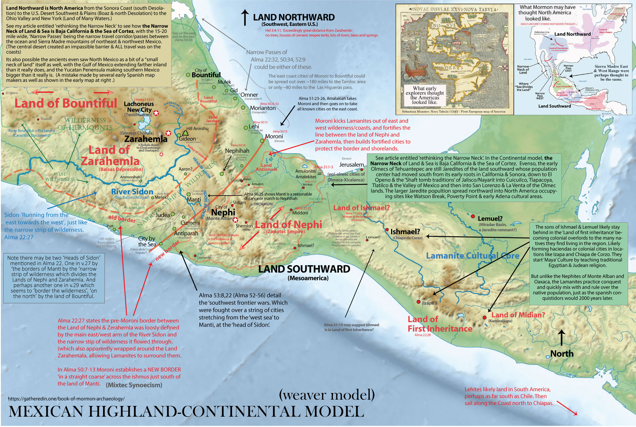
1 – THE NARROW NECK NORTH OF THE LAND OF ZARAHEMLA IN ALMA 22:32 OF THE BOOK OF MORMON SOUNDS LIKE A NARROW ISTHMUS. I cover this issue in detail in my article entitled, ‘The Narrow Neck as Baja and the Sea of Cortez.’ In short, the most straight forward reading of the Book of Mormon text does indeed make the Narrow Neck sound like a very narrow Isthmus of no more than a day and a half’s journey or 15-30 miles across. (Especially if that’s already what you’re picturing in your mind). An isthmus of which the ONLY possible American analog is the 28 mile narrow north of the Darien Gap of Panama (which is probably still too wide for a “day and a half journey”, and has major issues with the stated “cites of the east sea, which are said to be east of the Land of Zarahemla). However, there are other ways to interpret Alma 50:34, Alma 52:9, Hel 4:6–7 Mormon 2:29 & Mormon 3:5–6.
MY EXPLANATION: In my model I reinterpret these scriptures to suggest that because the Book of Mormon never explicitly says that the Narrow Passes are ON the Narrow Neck, and that nothing indeed actually is said to occur ON the Narrow Neck (only BY it)— that the text allows for an interpretation where the Narrow Neck is actually the Baja Peninsula and was the defining geographic feature delineating the Boundary between their Land Northward (roughly US & Canada) vs. their Land Southward (roughly Mexico).
see The Narrow Neck as Baja and the Sea of Cortez for a detailed discussion on this topic.
Despite what I believe are valid rationalizations, its clear that the general isthmian impression given in Alma 22 is probably the number one weakness of this models correlation with the Book of Mormon text. (Although to be fair its a weakness shared to some extent by ALL N.American models except the “Panama as the narrow neck” models–which have bigger issues of their own. )
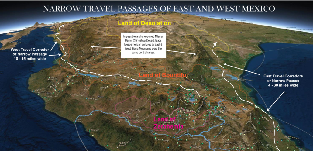
2 – CITY OF TEANCUM COULD BE CONSTRUED AS AN ISSUE. The city of Teancum is mentioned in association with the city of Desolation in the final battles/retreat of Mormon 4. The text seems to suggest that Desolation & Teancum are very close to each other. However, one would assume that a city named after Teancum would be very near the city of Bountiful on the East Coast since that is where Teancum died (if the city was named after the war general, which seems like a reasonable assumption, although certainly not stated in the text, or even implied).
MY EXPLANATION: However, Mormon seems to have come from the same area of ‘narrow neck area’ of Desolation near the Hill Shim (Mormon 1:3–6) and yet was named after the waters and forest of Mormon way down in the land southward, Angola is likely named after a region in Africa, and Moroni named after the early general from Zarahemla, so the naming of things in that region after places or people in the Land Southward does have precedence in the text. And Mormon seems to include a surprising amount of literature on the wars of Moroni suggesting things associated with those wars were important parts of the culture of Desolation where he lived. So it seems quite reasonable that the culture around Desolation and Boaz idolized the wars of Moroni to such a point that they named cities after ancient heroes regardless of it they were close to the locations of those ancient wars.
In fact some of the earliest cities in the Sonoran region have names coming from central or eastern Mexico, such as Culiacán, (spelled Culhuacan just like the important Aztec city in central Mexico on early maps). Also Pánuco Sinaloa, founded by Francisco de Ibarra in 1565, likely drawing from local naming and matching the city/river/province in Vera Cruz on the east coast. And matching the story told by Ixtlilxochitl of the Toltec king who went from the east coast to West Mexico. (find reference)
3 – DIRECTIONS. In regions like the Land of Zarahemla/ Nephi, the ‘sea west’ is not directly west, but south and west (excepting the Nayarit area where I believe Haggoth put in, which is directly west). Although, these minor directional issues are FAR less than those in the Heartland, or Mayanland models where directions must be rotated by a full 90 degrees to fit the text, they are still a bit different than the predominate internal models.
4 – DATING & TIMELINES. My models proposes two major claims about timelines and archaeological dates that many will find issue with, as I ascribe to errors on the part of Mormon or the spiritual translators. The model still works using traditional scriptural dates, but it works FAR better with the adjusted timelines. So to be clear, this is ONLY an issue with my secondary timeline possibility. The first is my belief that the early Jaredites arrived just before the end of the Ice Age and that the Great Dearth mentioned in Ether 9 in which “people did follow the course of the [flocks, herds, elephants, cureloms & cumoms], and did devour the carcasses of them which fell by the way, until they had devoured them all” (Ether 9:30–34). My belief that this section matches far too closely with what is known of the Younger Dryas climate event which caused the extinction of North America’s megafauna to not be what the authors were referring too. This however archaeologically dates to a time far outside what it assumed by the text and its reference to the Tower of Babel (9500 BC vs. 2300 BC?). However, no solid dates are given for the Jaredite timeline in the Book of Ether, so any solid dates for the Tower of Babel are purely assumptions anyway as far as the Book of Mormon is concerned. I also allow for the possibility that it is the radiocarbon dates that are in error instead of the assumed scriptural dates.
The second is my Nephite final exodus and genocide which I give two possibilities for. The first being the traditional date & Hopewell collapse circa 400AD, but the second possibility I correlate with the burning and abonnement of Tula, the massacres of Alta Vista and calchhuates, teh burials mounds of Guesave, the Chacoan phenomena buildup and collapse/burning and the Cahokia Mississippian buildup and collapse. All of which date to between 1050-1150 AD instead of 300-400 AD. Which I again ascribe to a mistake on the part of Mormon or the spiritual translators.
4 – DISTANCE LOGISTICS
The Continental model is based on the assumption that the ancient inhabitants of the America’s spoken of in the Book of Mormon were as adept at long distance sea and overland travel as the ancient cultures of Egypt and Persia and even the Arabs & Austronesians during short stints. If the reader has trouble believing in the mounting evidence that Bronze Age cultures of the Old World spread their technology of megalithic architecture, pyramid building, and sea-worthy ship building across the globe then the Continental Model is not for you. (perhaps you should stick to a pocket model). However, if you suspect from the similarities of Stonehenge, Egypt, The Javan Pyramids and the Bronze Age pyramids of Caral-Supe Peru that the ancients possessed globalized skill and technology that we have not yet given them credit for, then the Continental model may add significant insight to your worldview.
MY EXPLANATION: Its typical for those who have been sold on one of the Book of Mormon pocket models to raise concerns about the distances involved in the Continental model. Often these concerns involve misunderstandings in the Book of Mormon text itself or hypocritical arguments nearly identical to those levied against the Book of Mormon by critics who do not believe the Lehite or Jaredite or Mulekite overland and transoceanic voyages were possible given their interpretation of archaeological evidence.
Following are some evidence to the contrary.
- There is substantial evidence that the Teotihuacan Empire conquered the Soconusco region of Guatemala and that the Toltec’s conquered the area of Chichen Itza and that Aztec conquered Soconusco as well. Each of these regions are nearly 1000 miles from the Capital, showing the ancient Mexican Highland empire’s ability to subdue and hold long distance trading regions & outposts.
- We have ZERO indication of how many of either Nephites or Lamanites came from Zarahemla to the final battle. For all we know, they ALL came from desolation or Jordan. In my model scientists are working on figuring this out with dental isotope studies–because the dead bodies are everywhere.
- The Nephite exodus happened over a period of 50+ year period! Zarahemla to Sherrizah/Boaz 321-370, Boaz to Jordan 5-10 years.. to Cumorah another 8 years (370-374). Want to do the math of how far you’d need to travel each day? (and once again we have no idea how many traveled? Just a few little clues in a couple areas
- WATER! Like the saints who came from England, the Nephites/Lamanites would have UNDOUBTEDLY used water for transport. In my model their cities are predominantly along water trade hubs (all but about 200 miles of the way) IN FACT, logic suggests that’s why Cumorah was the battle spot. ITS THE END OF THE ROAD (the road being the Mississippi they used their canoes to travel)
- BEASTS OF BURDAN. Some suggest the Natives couldn’t travel distances like those traveled by peoples and armies in the Old World because they did not have beasts of burden. However, even though there is little to no reliable evidence of horses, Sahagun may suggest they used deer as transport animals (get reference). And Castaneda explains that the plains natives used large dog teams, just like the Eskimos to carry supply slays. In his Narrative of the Expedition of Coronado, Castaneda says “They travel like the Arabs, with their tents and troops of dogs loaded with poles[363][521] and having Moorish pack-saddles with girths” (see Ch.7, p362)
- NAKED EVEN IN THE COLD. Some suggest that the US region of North America could not be the land spoken of in the Book of Mormon because its too cold for the animal skin loin cloth dress mentioned in Alma 3:5. However Casteneda contradicts this in his Narrative of the Expedition of Coronado, saying that even in the snowy highlands of the Southwest, “the young women in that province went entirely naked, however cold it might be, and… the virgins had to go around this way until they took a husband, and that they covered themselves after they had known man. The men here wear little shirts of tanned deerskin and their long robes over this” (Ch.4, p355). Of those in the south Cabeze De Vaca says “The Indians we had so far seen in Florida are all archers. They go naked, are large of body, and appear at a distance like giants” (Ch.7 p. 33). Speaking of Texas he again says “The inhabitants of all this region go naked. The women alone have any part of their persons covered, and it is with a wool that grows on trees. The damsels dress themselves in deer-skin.” (Ch.15,p.35). In the Northern reaches of the Pecos River near Oklahoma & the Texas panhandle where our city of Jordan is near, De Vaca also describes many of the natives as “entirely naked”, he says “They go entirely naked after the manner of the first we saw. The women are dressed with deer-skin, and some few men, mostly the aged, who are incapable of fighting” (see Ch.30.p.104)
- TULA in the plains. De Soto says specifically that Tula was not far from Naguatex & The Nadaco which is thought to be in Texas or Oklahoma. He says “hey arrived in the Governor’s presence weeping, after the usage of Tula (thence to the eastward not very distant), when the chief, making his proper obeisance, thus spoke” (Ch.33.p241). The land or city of Tula is mentioned again by De Soto near Paacha & Autiamque. He says, “from thence to Pacaha northwardly, to Tula westwardly, to Autiamque southwardly”. These locations are thought to be in modern Arkansas. (Ch.44.p271)
- BOATS. One of the best descriptions of the few ‘mega-boats’ built and used by the natives of North America comes from the native guide of the Coronado Expedition who they nick-named ‘Turk’. In Castaneda’s account he quotes Turk saying “in his country there was a river in the level country which was two leagues wide [The Mississippi, which ranges from 1 mile in the dry season to over 11 miles in high run off], in which there were fishes as big as horses, and large numbers of very big canoes, with more than twenty rowers on a side, and that they carried sails, and that their lords sat on the poop under awnings, and on the prow they had a great golden eagle. (see Ch.13.p.314) These boats could have been used for transport of people and supplies during exploration and war travels. Explorer Hernando de Soto seems to verify this in his journey along the Mississippi relating how they were attacked often daily by large numbers of well stocked canoes. In one account he perhaps exaggerates that, “The next day a hundred canoes came together, [some?] having from sixty to seventy persons in them [each], those of the principal men having awnings, and themselves wearing white and colored plumes, for distinction.” Thereafter he explains how the native “canoes were larger than [those of the Spanish],” and from them armies of native people’s relentlessly attacked them. (see Ch.37.p.257)
As far as logistics is concerned, if you’re going one hundred miles, the logistics of going a few thousand is no different. You just do the exact same daily logistical thing, for a much longer period. (which often involves plunder and conscription of local populations.) We have no indication that these final battle armies used advanced roman/Mongol type supply support chains instead of migrate & go techniques.
– WEST AMERICAN DESERTS ARE ONLY TRULY DESOLATE PART OF NORTH AMERCA. In the Continental Model, the names of lands are excellent descriptors of the the ecology. Many Waters, is the part of the continents with the most/largest rivers & water bodies, Desolation, is the part of the continent that is most desolate. Bountiful is the most productive part of Mexico where more than half its population lives. Two Cumorah proponents often suggest that the Land of Desolation, was called such, ONLY because of the ‘Desolation’ or destruction of people. Not because the region was also naturally desolate as far as vegetation goes. This textual uncertainty is caused because of ambiguity in both the definition and the usage in the text. Desolate, can be defined as 1. destitute or deprived of inhabitants; desert; uninhabited, or 2. laid waste; in a ruinous condition. (see 1828 dictionary). Note that Hel 3:6 can be read in two different ways each with different meanings depending on whether you define ‘desolate’. For example.
6 And now no part of the land was desolate [destitute or deprived of inhabitants; desert; uninhabited], save it were for timber; but because of the greatness of the destruction of the people who had before inhabited the land it was called desolate. (Hel 3:6)
6 And now no part of the land was desolate [laid waste; in a ruinous condition], save it were for timber; but because of the greatness of the destruction of the people who had before inhabited the land it was called desolate. (Hel 3:6)
So then the question is, was the Land of Desolation, actually Bountiful when it comes to vegetation, rain, soil & fertility but simply laid waste of people? Or was it BOTH a desert, destitute/deprived of inhabitants; AND laid waste of inhabitants. The text might lead us to believe its only the first case. Except then we must ask ourselves, how is it that in Mosiah 8:11, the Lemhite explorers found that the swords had all rusted and hilts had ‘perished, but the people’s bones had not disintegrated? (see also Alma 22:30) In an area like Teahuantepec we’d have to assume the Jaredite war occurred less than a decade or two before being found by the explorers. Likewise, how is it that the trees had not grown back in Hel 3:9 so that they had to be shipped in from surrounding areas? (Note the region spoken of in Hel 3:4–5 are two different regions, Many Waters, and Desolation
.
THESE ARE ALL FAIRLY MINOR ISSUES, AND THE CONTINENTAL MODEL EFFECTIVELY SOLVES MOST ISSUES IN THE OTHER PREDOMINATE MODELS.
The strength of my continental model is how by making this one assertion that narrow neck is different from the most straight foreword reading of the text– the rest of the book really just ends up fitting unbelievably well with basically the buildup and notable collapses of nearly EVERY SINGLE major culture on the continent. From the Adena & Hopewell to the ancient Puebloans/Anasazi, Teotihuacan & Mexican Highland to the Zapotec and Olmec and even archaic and Paleoindian groups.
– If you’d like to contribute to a list of issues, please email them to me.
See Book of Mormon Geography: An Internal Model
.
THINGS STILL TO SOLVE, OR THINGS OTHERS COULD WORK ON.
-The logic between the land of Antionum and Jerusalem. I’m not sure my logic on this is completely solid as the text is a bit ambiguous. There is a small possibility Jerusalem is on the west coast, but I dont think so, but Aaron going on a mission there on the way to Ishmael is interesting. Could Antionum be so far south as Palenque? Is there more evidence Chiapa de Corzo is Ishmael?
-Lots of work needs to be done on West Mexico.
.
A CRITICAL LOOK AT THE VALLEY OF MEXICO AS ‘MANY WATERS’/CUMORAH MODEL
Some have suggested the Valley of Mexico to be the ‘many waters’ of the land Northward, and the
-Chapultepec (his hill Cumorah) is directly west of the ancient lake Texacoco, which doesn’t fit well with the description in Ether 15:8–10 where the army of Coriantumr went south of Ripliancum to Ogath/Cumorah.
-Nor does it work with Omer who “passed by the hill of Shim, and came over by the place where the Nephites were destroyed, and from thence eastward, [to] the seashore” (Ether 9:3). If Moron is on Tehuantepec, why would Omer head to the Valley of Mexico on his way to Ablom? That’s a difference of 200 miles (for the direct route) verses 500 miles to go to the Valley of Mexico first. Why such a huge, strange detour? The text makes it sound like Cumorah was on the way to Ablom on the sea. If this wasn’t the case, wouldn’t the text say? (perhaps he had business to take care of, but the text just doesn’t seem to imply such).
-Add to this the strange indirectness of the path to Desolation and Cumorah during the final battle. As the text has the Nephites fleeing from Zarahemla first to Joshua on the west coast (Mormon 2:6) before then crossing to the M2C Desolation which is always correlated with the Olmec lands on the North Coast of Tehuantepec, and then on to the Valley of Mexico. The text never mentions crossing to the East Sea, but the question is, if the Nephite Land of Desolation is on the east coast, why did the army retreat from Zarahemla to the west coast instead of taking the obviously more direct north routes through Chiapa de Corzo? And why is not a single known ‘east coast’ city mentioned in their retreat? There’s no mention of Nephihah, Mulek or Bountiful? If this geography is correct, these omissions seem strange.
-Really however, these issues pale compared to the archaeological/socio-political issues with this model. Particularly because Teotihuacan and the Valley of Mexico was by far the largest population center and political force on the continent in 300 AD; truly akin to Egypt or Babylon or Rome in the Bible. It seems almost impossible that the Book of Mormon would simply fail to mention such a political power, so most M2C proponents suggest this city was the Lamanite ally ‘Gadiantons’ mentioned in Mormon 1:18 & Mormon 2:27–28. However, this doesn’t make much sense either, because Mormon 2:27 clearly shows the Lamanites & Gadiantons were allies fighting against the Nephites. Yet, Mormon 2:28–29 has a treaty giving the Land Southward to the Lamanites and the Land Northward to the Nephites! “29 And the Lamanites did give unto us the land northward, yea, even to the narrow passage which led into the land southward. And we did give unto the Lamanites all the land southward.” (Mormon 2:29) How does that work? Since its unrealistic to suggest the Nephites beat the Teotihuacan empire with their 40,000 troops, M2C proponents assume that the “us” in this verse is suddenly opposite the Lamanite & Gadianton Alliance mentioned in v. 27, and now the Gadiantons are allied with the Nephites! However, if this were the case, the archaeological evidence suggests there is no way that any Mayan Lamanite force would have been able to beat the Nephites in the final battle! The Cumorah as the Valley of Mexico model tries to overcome the idea of the Maya bringing many tens of thousands of troops into Teotihuacan territory in Veracruz by having Teo..
-So who are the Teotihuacanos? Nephites, Lamanites or Gadiantons? (every one of these have issues). Either way, there is ZERO archaeological evidence of a massive siege and battle on Grasshopper hill. Surely if 230,000 people were holed up on a hill on the edge of such an urban environment they would have fortified it. But if Nephites, wouldn’t the Lamanite army then take over Teotihuacan? And that Lamanite army would have still had to travel 800 miles, likely all on land from the Land of Nephi. If Gadiantons, then why ON EARTH, would the Nephites flee into the belly of their culture?!!


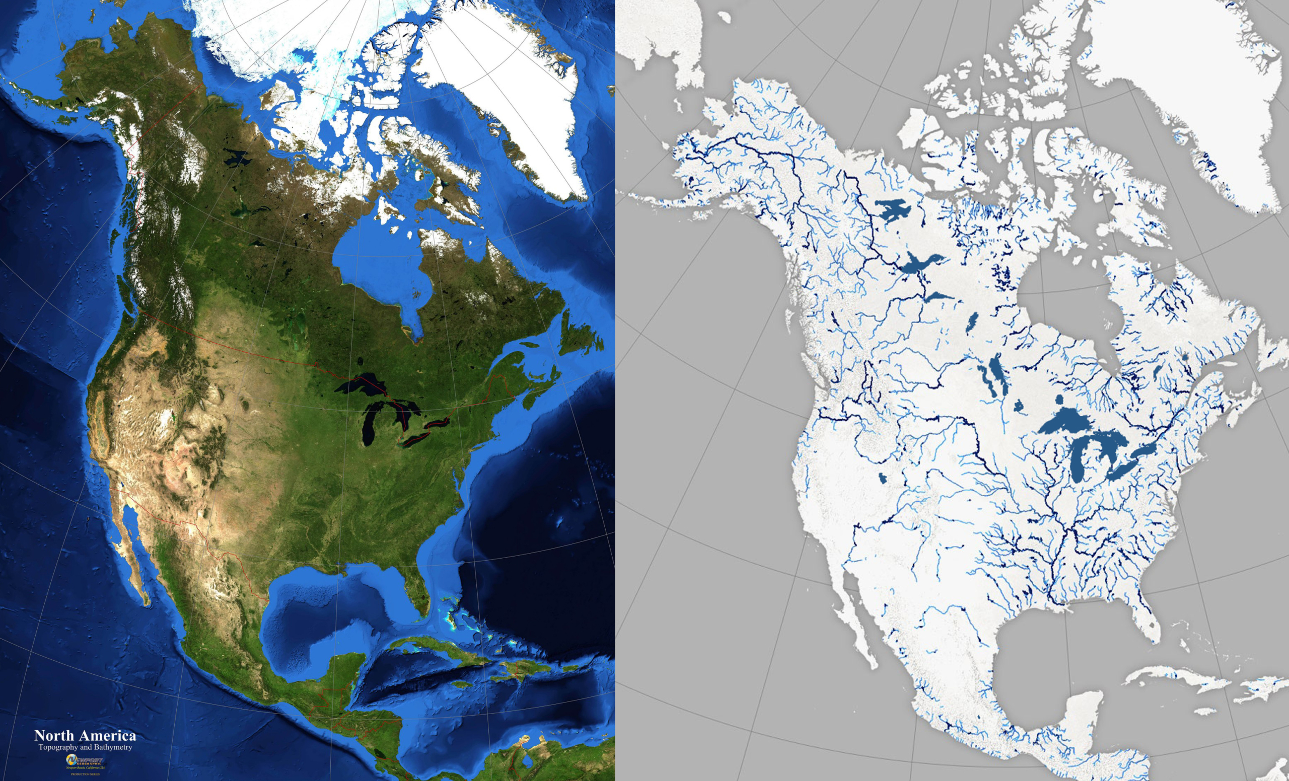
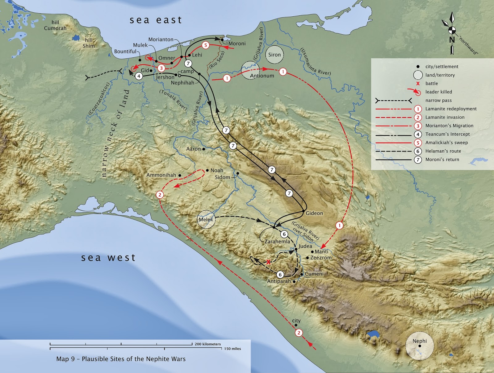
Leave a Reply
Want to join the discussion?Feel free to contribute!