Joseph Smith Quotes on Book of Mormon Geography
This page is a compilation of quotes directly attributed to Joseph Smith or in official publications of which he was chief editor before his death relative to the geography of the Book of Mormon. Non-direct quotes of Geographic information are included only when substantiating direct quotes.
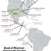
From the available documented evidence it is apparent Joseph held a continental view of Book of Mormon Geography. Quotes by Joseph Smith or statements attributed to him point to a belief in four major areas of Book of Mormon happenings.
1- He believed the Lehites to have landed in South America
2- He believed them to have travelled to Central America to settle (with cities/lands like Zarahemla & Nephi being there).
3- He believed the the Land Desolation or where the Nephites ‘lost their power’ to be in the U.S. Southwest & Great Plains.
4- He believed Cumorah and the final battle to be in New York, and much of North America to be the Book of Mormon ‘Land Northward’ and/or Jaredite territory.
Currently, most LDS church Book of Mormon geography researchers are split between believing and disbelieving half of Joseph’s geographic model. With “Heartlanders” believing points 3 & 4 above and Mesoamericanists believing point 2 & Hemispheric & South American modelers believing 1 above. And because of the Narrow Neck problem neither side can see eye to eye or believe ALL of Joseph Smith’s quotes. (See this article for information on the Narrow Neck problem, and its solution.) This article also clearly refutes the mistaken belief that Joseph Smith advanced a Hemispheric model, showing that not a single Joseph Smith quote supports this model advanced later by Orson Pratt.
And although it seems possible or even likely that Joseph Smith did not receive specific revelation pertaining to specific cities of where Book of Mormon events took place, when taken as a whole, the descriptions he gives of Book of Mormon locations are fairly consistent and seem to suggest a generalized knowledge of Book of Mormon lands. Some modern LDS scholars believe that Joseph learned the geography as time progressed or perhaps didn’t have a concrete idea in his mind about where it took place at all, however, quotes like the following from Joseph Smith himself and then another from Lucy Mack Smith as well as others contained in this document seem to suggest otherwise.
I was also informed [by the angel] concerning the aboriginal inhabitants of this country and shown [in vision?] who they were, and from whence they came; a brief sketch of their origin, progress, civilization, laws, governments, of their righteousness and iniquity, and the blessings of God being finally withdrawn from them as a people, was made known unto me; I was also told where were deposited some plates on which were engraven an abridgment of the records of the ancient Prophets that had existed on this continent. The angel appeared to me three times the same night and unfolded the same things. After having received many visits from the angels of God unfolding the majesty and glory of the events that should transpire in the last days, on the morning of the 22nd of September, A.D. 1827, the angel of the Lord delivered the records into my hands.
(Joseph Smith, Wentworth Letter. JS, History, 1838–1856, vol. C-1, created 24 Feb. 1845–3 July 1845; handwriting of Thomas Bullock, Franklin D. Richards, Jonathan Grimshaw, and Leo Hawkins; 512 pages. Original available here)
“During our evening conversations, Joseph would occasionally give us some of the most amusing recitals that could be imagined. He would describe the ancient inhabitants of this continent, their dress, mode of traveling, and the animals upon which they rode; their cities, their buildings, with every particular; their mode of warfare; and also their religious worship. This he would do with as much ease, seemingly, as if he had spent his whole life among them.”
(Lucy Mack Smith, History of Joseph Smith by His Mother [Salt Lake City: Stevens & Wallis, Inc., 1945], 83.)
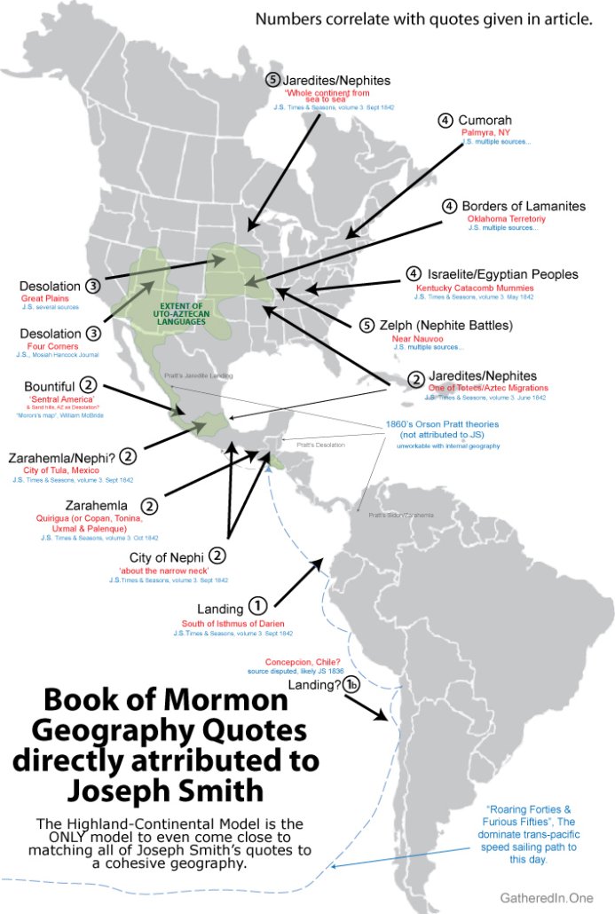
(1) –Quotes Suggesting Joseph Believed the Lehites Crossed the South Pacific & Landed in Western South America.
In this article from the Times & Seasons, edited (and possibly written) by Joseph Smith, the author states that the Lehites landed a bit south of the Isthmus of Darien (Which was an old name for Panama).
When we read in the Book of Mormon that… Lehi went down by the Red Sea to the great Southern Ocean, and crossed over to this land, and landed a little south of the Isthmus of Darien, and improved the country according to the word of the Lord… Surely “facts are stubborn things.” It will be as it ever has been, the world will prove Joseph Smith a true prophet by circumstantial evidence, in experiments, as they did Moses and Elijah.
Times and Seasons, 15 Sept. 1842, vol. 3, no. 22, pp. 911–926, edited by JS
Note that, as shown in this 1835 New England publication, that although the term “Great Southern Ocean” or just “Southern Ocean” could be used interchangeably to refer to both the south Atlantic between south America & Africa—as well as the south Indian & Pacific oceans between south Africa (Cape Horn), Tasmania (Van Dieman’s Land), New Zealand, and South America (Cape of Good Hope), the logic of using the south Atlantic to land a boat, “a little south of the Isthmus of Darian” is impossible. Thus he is obviously referring to the ‘Great South [Pacific] Sea’, as seen in the following maps. Payne-1798, Laurie-1800, Ortelius-1600s, Alzate-1768.
The above statement is supported by the following quote recorded by Frederick G. Williams and originally published in 1879 by Orson Pratt, suggests that Lehites landed in Chile, though of questionable authenticity and unknown origin, at least two separate individuals appear to have recorded it (although one could be based on the other, and the time of recording is decades after Joseph’s death). It is included only because it corroborates the Times & Seasons quote above of a South American first landing, and is directly attributed to Joseph Smith. (Combined with other quotes it suggest the Lehites then went up the coast to Mesoamerica before founding the cities of Nephi or Zarahemla)
They traveled nearly a south, southeast direction until they came to the nineteenth degree of north latitude; then, nearly east to the Sea of Arabia, then sailed in a southeast direction, and landed on the continent of South America, in Chile, thirty degrees south latitude.
Franklin D Richards & James Little, 1844 Publication. Attributed to ‘Joseph the Seer’. Similar quote also attributed to Frederick G. Williams as presented to Church history archives by Nancy Williams in 1860’s, suggestedly originating from J.S. speech at Kirtland Temple Dedication in 1836. (more information available here) Also found (originally?) in John Bernhisel’s copy of Joseph Smith’s New Translation of the Bible. pg. 135, Church History Library MS 21927.
It’s been suggested by some Heartland proponents that Frederick simply misheard Joseph speaking of “30 degrees latitude” and made up the “south” and the “landing on the continent of South America” and that the “little south of the isthmus of Darien” in the Times & Seasons was written without Joseph’s knowledge. They suggest what Joseph “actually” said was that Lehi landed 30 degrees north latitude in Florida. This however is a considerable stretch, considering that there is yet a third quote placing the Nephite landing in western South America, given by none other than Oliver Cowdery. (Who we will see below is an important source in proving the Joseph Smith’s belief in a single New York Cumorah.) An 1830 article in the anti-Mormon publication Observer and Telegraph quotes Oliver as a third witness of the South American landing saying,
According to the narrative given by one of these disciples—Oliver Cowdery—at their late exhibition in Kirtland.. This new Revelation, they say is especially designed for the benefit, or rather for the christianizing of the Aborigines of America; who, as they affirm, are a part of the tribe of Manasseh, and whose ancestors landed on the coast of Chili 600 years before the coming of Christ, and from them descended all the Indians of America.
“The Golden Bible, or, Campbellism Improved,” Observer and Telegraph (Hudson, Ohio), November 18, 1830
Note: I’m working on remaking a video that gives some insight refuting the logic suggesting Joseph advanced a hemispheric model. (There’s not a single direct quote suggesting Joseph promoted Orson Pratt’s hemispherical model. But to the contrary he put Zarahemla & Nephi in ‘central america’.) And note that all the issues brought up in this video are solved with the obvious presumption that Lehi landed temporarily in South America to restock and perhaps even drop off/pick up crew members (such as one/some of Ishmael’s sons?) and then continue on to Mesoamerica where other quotes suggest the Nephites settled.
(2) –Quotes suggesting Joseph believed the Lehites settled in Mesoamerica.
In the same Times & Seasons article referenced above (edited & possibly written by Joseph Smith) the author explicitly states that the Jaredites of the Book of Mormon stretched across the entire North American continent (ie. ‘this’ continent). Later in this section we’ll also address the theories suggesting that John Bernhisel wrote and published these articles without Joseph’s knowledge or approval.
When we read in the Book of Mormon that Jared and his brother came on to this continent from the confusion and scattering at the Tower, and lived here more than a thousand years, and covered the whole continent from sea to sea, with towns and cities…
Times and Seasons, 15 Sept. 1842, vol. 3, no. 22, pp. 911–926, edited by JS
Similarly, another Times and Seasons article summarizes the ideas from Alexander Von Humbolt’s 1814 book Researches concerning the institutions & monuments of the ancient inhabitants of America. Here the author draws on similarities between the Book of Mormon story of the Jaredites and Aztec & Toltec legends along with biblical stories of the flood and tower of babel. Of particular note in this discussion is the reference to Von Humbolt’s assertion that Aztec’s or Toltecs from the Valley of Mexico had migrated to the Great Lakes region, which they called Aztlan, and mixed with the Iroquios and Huron peoples. (see Humbolt, p.171)
But among [those after the flood] there were 15 heads or chiefs of families, which were permitted to speak the same language, and these were the Toltecs, the Aculhucans and Azteca nations who embodied themselves together, which was very natural, and traveled they knew not where, but at length arrived in the country of Aztalan, or the [Great] lake country in America…
…the tradition and hyeroglyphics of the Zaltees, the Colhuacans, and the Azteca nations, in regard to the confusion of languages and their travels to this land, is so like that contained in the Book of Mormon, that the striking analogy must be seen by every superficial observer…
These accounts, then, precisely agree, one of which was found in Ontario county, N. Y., and the other in Mexico. Again, those nations, or families, embodied themselves together and traveled they knew not where, but at length arrived in the country of Aztalan, or the [Great] lake country of America.
Times and Seasons, 15 June 1842, vol. 3, no. 16, pp. 815-830, edited by JS
Quotes from Humbolts book
“A few Tolteck tribes appear to have mixed with the nations, who formerly inhabited the country lying between the eastern bank of the Mississippi and the Atlantic ocean. The Iroquois and the Hurons made hierogtyphical paintings on wood, which bear a striking resemblance with those of the Mexicans* ; they indicated the -names of the persons they meant to represent, by employing the same means, which we have already mentioned in the description of a genealogical painting.” (p.171)
The tongues, which the dove distributed to the nations of America, being infinitely varied, these nations disperse, and fifteen heads of families only, who spoke the same tongue, and from whom the Toltecks, the Aztecks, and the Acolhuans descended, unite, and arrive at Aztlan, (the country of the garces or flamingoes). The bird placed on the hieroglyphic of water, aél, denotes Aztlan. The pyramidical monument with steps isa teocalli. I am astonished at finding a palm tree near this teocalli: this plant certainly does not indicate a northern region; nevertheless it is almost certain, that we must look for the first country of the Mexican nations, Aztlan, Huehuetlapallan, and Amaquemecan, at least North of the 42d degree of latitude. (p.66)
The annals of the Aztecks begin, according to Gama, at an epocha corresponding to the year 1091 of our era; a period at which, by order of their chief Chalchiuhtlatonac, they celebrated the festival of the renewal of the fire at Tlalixco, called also Acahualtzinco, situate probably under the parallel of thirty-three or thirty-five north latitude. It is only since the year 1091, in which as the Indian historian Chimalpain expressly says, they tied for the first time the years after their going forth from Aztlan, that Mexican history presents the greatest order, and an astonishing minuteness in the recital of events.” (p.299)
Note that an entire section of Humbolts book is dedicated to Mitla in Oaxaca (my Land of Nephi). See page 153-159, including drawings. However, least someone suggest Joseph Smith simply copied Von Humbolt, note there is not mention of Monte Alban or dates (my City of Nephi).
The referencing of Von Humbolt’s book in the Times and Seasons is notable for many reasons, but one should take into account the many allusions in the book to the Toltec migrations from Aztlan which the Times & Seasons author places near the Great Lakes. The article also references the Aztec migration found in the annals of Domingo Chimalpahin from a city named Acahualtzinco, “situated probably under the parallel of thirty or thirty five north latitude… since the year 1091” (p. 299-309, Humboldt). This is roughly the latitude encompassed by Arkansas and again suggests native American beliefs in regular migrations from Mexico to the Heartland region of the Eastern United States.
Building on the ideas of the previous quote, the following article from Time and Seasons (edited & possibly written by Joseph Smith) re-quotes the Spanish Chronicler, Francisco Antonio Fuentes and seems to equate the Lehites or Mulekites with Toltec legends suggesting they founded the City of Tula in the Valley of Mexico. (Although the author contradicts himself, comparing the Toltec migration with the Jaredites in one quote, and then later applying it to the Lehites as an Israelite group coming to America–despite the fact that Hombolt’s book clearly puts these migrations around 1000 AD of a group moving from the Valley of Mexico to the Eastern United States.)
Lehi went down by the Red Sea to the great Southern Ocean, and crossed over to this land… Now read Stephens’ story: “According to Fuentes, the chronicler of the kingdom of Guatumala, the kings of Quinche and Cachiquel were descended from the Toltecan Indians, who, when they came into this country, found it already inhabited by people of different nations. According to the manuscripts of Don Juan Torres, the grandson of the last king of the Quiches…the Toltecas themselves descended from the house of Israel, who were released by Moses from the tyranny of Pharaoh, and after crossing the Red Sea, fell into Idolatry. … and under the guidance of Tanub, their chief, passed from one continent to the other, to a place which they called the seven caverns, a part of the kingdom of Mexico, where they founded the celebrated city of Tula.”
Times and Seasons, 15 Sept. 1842, vol. 3, no. 22, pp. 911–926 edited by JS.
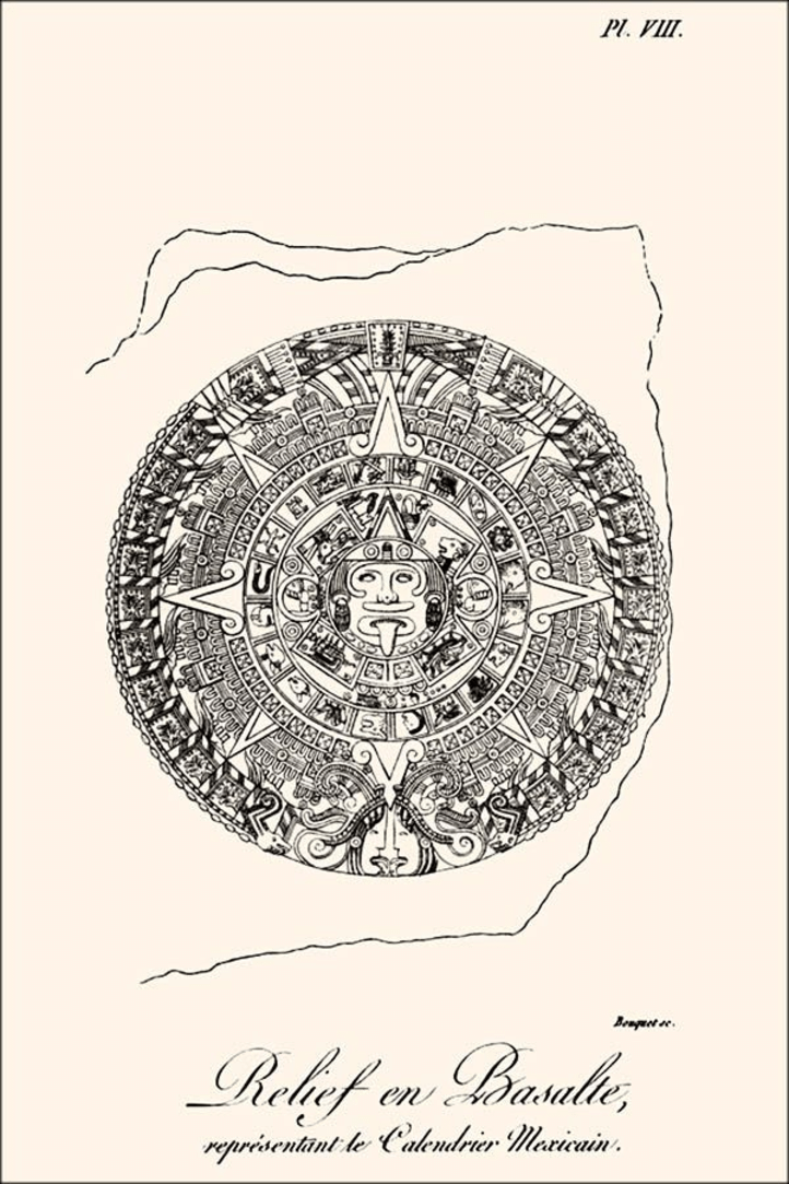
All this talk of the Aztecs of Mexico is particularly relevant because the Book of Mormon characters given by Joseph Smith to Charles Anthon (ie. The Anthon Transcript) was said by Anthon himself to also contain an Aztec Calendar! This piece of evidence directly links Joseph Smith and Book of Mormon characters copied from the plates with Aztec motifs!
In a letter dated to 1834 (quoted in Howe 1834, 271–72) Anthon described what was on the Harris document (Anthon Transcript) saying that “It consisted of all kinds of crooked characters disposed in columns, and had evidently been prepared by some person who had before him at the time a book containing various alphabets… and the whole ended in a rude delineation of a circle…evidently copied after the Mexican Calendar given by Humboldt”
Farther on in the preceeding Times and Seasons article is found a large portion from Stephen’s Incidents of Travel in Central America, Chiapas, and Yucatan, which shows that the author most certainly believed the city of Nephi to have been in Central America [Mesoamerica] somewhere near the Isthmus of Tehuantepec or Guatemala where John Lloyd Stephens laid out his explorations in the quoted book.
Let us turn our subject, however, to the Book of Mormon, where these wonderful ruins of Palenque are among the mighty works of the Nephites:-and the mystery is solved…
Times and Seasons, 15 Sept. 1842, vol. 3, no. 22, pp. 914-915 edited by JS. Brackets mine. Referring to Stephens Incidents found here.
On the 72d page of the third and fourth edition of the Book of Mormon it reads as follows: And it came to pass that we began to prosper exceedingly, and to multiply in the land. And I, Nephi, did take the sword of Laban, and after the manner of it did make many swords, lest by any means the people who were now called Lamanites, should come upon us and destroy us: for I knew their hatred towards me and my children, and those who were called my people. And I did teach my people, to build buildings: and to work in all manner of wood, and of iron, and of copper, and of brass, and of steel, and of gold, and of silver, and of precious ores, which were in great abundance. And I, Nephi, did build a temple; [ie. the City of Nephi] and I did construct it after the manner of the temple of Solomon, save it were not built of so many precious things: for they were not to be found upon the land; wherefore, it could not be built like un-to Solomon’s temple. But the manner of the construction was like unto the temple of Solomon; and the workmanship thereof was exceeding fine. And on page 280-1 is a full description of the Isthmus.
Mr. Stephens’ great developments of antiquities are made bare to the eyes of all the people by reading the history of the Nephites in the Book of Mormon. They lived about the narrow neck of land, which now embraces Central America [ie. Mesoamerica], with all the cities that can be found. Read the destruction of cities at the crucifixion of Christ, pages 459-60. Who could have dreamed that twelve years would have developed such incontrovertible testimony to the Book of Mormon? surely the Lord worketh and none can hinder.
A following issue of the Time and Seasons contains a follow up article building on the last and stating that “The city of Zarahemla…stood upon the land [of Central America or Guatemala]. He also offers his opinion that the “ruins of Quirigua are those of Zarahemla,” but without “declaring it positively”.
Since our ‘Extract’ was published from Mr. Stephens’ ‘Incidents of Travel,’ &c., we have found another important fact relating to the truth of the Book of Mormon. Central America, or Guatemala, is situated north of the Isthmus of Darien and once embraced several hundred miles of territory from north to south.-The city of Zarahemla, burnt at the crucifixion of the Savior, and rebuilt afterwards, stood upon this land as will be seen from the following words in the book of Alma:-‘And now it was only the distance of a day and a half’s journey for a Nephite, on the line Bountiful,and the land Desolation, from the east to the west sea; and thus the land of Nephi, and the land of Zarahemla was nearly surrounded by water: there being a small neck of land between the land northward and the land southward.’ [See Book of Mormon 3d edition, p. 280-81.]
It is certainly a good thing for the excellency and veracity, of the divine authenticity of the Book of Mormon, that the ruins of Zarahemla have been found where the Nephites left them: and that a large stone with engravings upon it, as Mosiah said; and a ‘large round stone, with the sides sculptured in hieroglyphics,’ as Mr. Stephens has published, is also among the left remembrances of the, (to him,) lost and unknown. We are not going to declare positively that the ruins of Quirigua are those of Zarahemla, but when the land and the stones, and the books tell the story so plain, we are of opinion, that it would require more proof than the Jews could bring to prove the disciples stole the body of Jesus from the tomb, to prove that the ruins of the city in question, are not one of those referred to in the Book of Mormon.
It may seem hard for unbelievers in the mighty works of God, to give credit to such a miraculous preservation of the remains, ruins, records and reminiscences of a branch of the house of Israel: but the elements are eternal, and intelligence is eternal, and God is eternal, so that the very hairs of our heads are all numbered. It may be said of man he was and is, and is not; and of his works the same, but the Lord was and is, and is to come and his works never end; and he will bring every thing into judgment whether it be good, or whether it be evil; yea, every secret thing, and they shall be revealed upon the house tops. It will not be a bad plan to compare Mr. Stephens’ ruined cities with those in the Book of Mormon: light cleaves to light, and facts are supported by facts. The truth injures no one, and so we make another
Times and Seasons, 1 Oct. 1842, vol. 3, no. 23, pp. 927–942 edited by JS. Brackets mine.
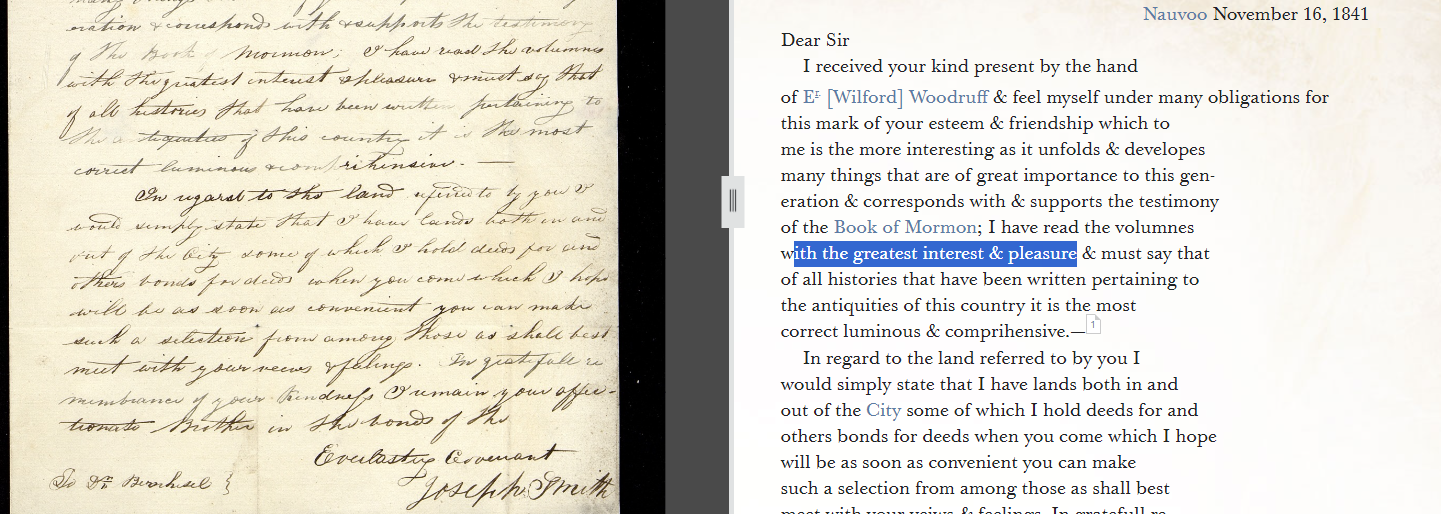
Some have questioned Joseph’s involvement or support of the Times & Season’s articles which support a South American landing & Mesoamerican settling of the Lehite group. However, the idea that Joseph was not involved in publishing these articles is incredibly unlikely given the following evidence in the Joseph Smith Papers, where we have copies of the letter (possibly dictated through a scribe) and sent to John Bernhisel signed by Joseph Smith, to thank him for gifting him the copy of Stephen’s Incidents of Travels which were quoted by the Times & Seasons. He says in the letter SPECIFICALLY, the same statement as made in the Times & Seasons that the book, “supports the testimony of the Book of Mormon”. Regardless of whether this letter was written directly by Joseph or dictated through a scribe, to cast doubt upon such correspondences as unapproved proxy letters which Joseph neither dictated nor approved, one must then doubt ALL letters and revelations attributed to Joseph Smith through his scribes as possible forgeries by his trusted associates!
.
Dear Sir
(Joseph Smith Papers, JS, Letter, Nauvoo, Hancock Co., IL, to John M. Bernhisel, New York City, New York Co., NY, 16 Nov. 1841
I received your kind present [of Stephen’s Incidents of Travel in Central America] by the hand of E. Woodruff & feel myself under many obligations for this mark of your esteem & friendship which to me is the more interesting as it unfolds & developes many things that are of great importance to this generation & corresponds with & supports the testimony of the Book of Mormon; I have read the volumes with the greatest interest & pleasure & must say that of all histories that have been written pertaining to the antiquities of this country it is the most correct luminous & comprehensive…
Joseph Smith
To Dr [John] Bernhisel
Nauvoo, Ill, Nov 23rd
Despite the Bernhisel letter, some still protest that John Taylor or Wilford Woodruff may have written the The Times & Seasons extracts without Joseph’s approval and knowledge of the content. However scholarship available here and statistical analysis suggests that Joseph Smith’s stylistic influence is the strongest of the three possible editors.
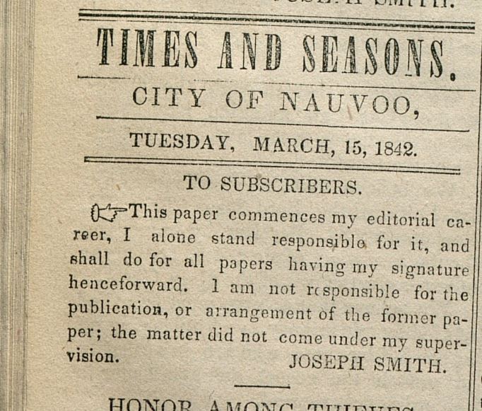
Additionally, just months before the Times & Seasons editions most of the quotes on Mesoamerican BOM geography come from, Joseph Smith printed the below statement claiming explicit responsibility for publications in future publications. Indeed, given this evidence, nothing short of mental gymnastics can support the belief that Joseph Smith did not support a continental model of the Book of Mormon which included lands south of the United States.
“This paper commences my editorial career, I alone stand responsible for it, and shall do for all papers having my signature henceforward. I am not responsible for the publication, or arrangement of the former paper [before march 1842]; the matter did not come under my supervision. -JOSEPH SMITH”
Times and Seasons (Nauvoo, Hancock Co., IL), 1 Mar. 1842, vol. 3, no. 9, pp. 703–718; edited by JS.
Outline of All Times & Seasons Articles Dealing with B.O.M. Geography
All together, there are seven articles in the Times and Seasons which draw correlations between archaeological sites and Book of Mormon lands. The first of these correlates Kentucky with BOM lands, the second, a phylactery & Hebrew writing on a mound item in Pittsfield Massachusetts with the B.O.M. The third correlates both the Great Lakes and Mexico with Book of Mormon lands & peoples, and the last four equate Mesoamerican sites with Book of Mormon lands. Given that the Times & Seasons articles support a continental model (not just a Mesoamerican or Heartland Model), which agrees with later maps made by Utah Saints, and attributed to Joseph Smith, it seems incredibly unlikely that these Times & Seasons articles are just some quack theory of Woodruff and Bernhisel published to Joseph’s official publication without his knowledge or consent.
- ‘A Catacomb of Mummies found in Kentucky’, Times and Seasons, 2 May. 1842, vol. 3, no. 13, pp. 781 signed ed.
- ‘American Antiquities’, Times and Seasons, 1 June 1842, vol. 3, no. 15, pp. 813–814, unsigned.
- ‘Traits of the Mosaic History found among the Azteca Nations’, Times and Seasons, 15 June 1842, vol. 3, no. 16, pp. 815-830, signed by editor
- ‘American Antiquities’, Times and Seasons, 15 July 1842, vol. 3, no. 18, pp. 847–862, signed by editor
- Extracts from Stephen’s Incidents of Travel in Central America’ & ‘Facts are Stubborn Things’, Times and Seasons, 15 Sept. 1842, vol. 3, no. 22, pp. 911–926, unsigned
- ‘Zarahemla’, Times and Seasons, 1 Oct. 1842, vol. 3, no. 23, pp. 927–942, unsigned
- ‘Ruins Recently Discovered in Yucatan Mexico’, Times and Seasons, 15 Nov. 1842, vol. 4, no. 1, pp. 15-16, unsigned
(3) –Quotes suggesting the Nephite Land of Desolation stretched from the Great Plains to the Desert Southwest where the Nephites ‘lost their power’.
Mosiah Hancock recorded a first hand conversation he had with Joseph Smith saying that the Nephites lost their power in the Southwestern United States or Northmost Mexico. Mosiah would have been ten years old when Joseph was murdered, although his biographical descriptions of that year seem to be quite vivid, and this quote is included because it is corroborated not only by his father Levi Hancock (who was a close confidant of Joseph) as well as the other quotes below, such as Willium McBride’s quote and “Moroni’s Travels” maps, but also by Joseph’s direct quote to Emma equating Zion’s Camp with the “plains of the Nephites”, and Zelph’s death “during the last great struggle of the Lamanites and Nephites.”
“Now”, [Joseph] said, “I will show you the travels of this people”. He then showed our travels through Iowa, and said, “Here you will make a place for the winter; and here you will travel west until you come to the valley of the Great Salt Lake! You will build cities to the North and to the South, and to the East and to the West… But, the United States will not receive you with the laws which God desires you to live, and you will have to go to where the Nephites lost their power... placing his finger on the map, I should think about where Snowflake, Arizona is situated, or it could have been [north most] Mexico
Mosiah Hancock, Autobiography, BYU Special Collections, Writings of Early Latter-day Saints 28. Original is here. Brackets mine.
From Levi Hancock’s record of Zion’s Camp (1834):
“Nothing occurred of any account until we got in Illinois when Joseph said, in our tent, “I want you to remember what I say to you. The Lord is going to give us dry weather now until we get through. He has given rains that there might be water on the prairies. You will see the movings of the Lord in our favor all the way through.” It began to be very pleasant and soon we entered on the wide prairies camping and holding meetings on Sunday…
…On the way to Illinois River where we camped on the west side. In the morning many went to see the big mound about a mile below the crossing. I did not go on it but saw some bones that were brought back with a broken arrow. They were laid down by our camp. Joseph Smith addressing himself to Sylvester Smith and said, “This is what I told you and now I want to tell you that you may know what I meant. This land was called the land of desolation and Onedages was the King and a good man was he. There in that mound did he bury his dead and did not dig holes as the people do now, but they brought their dirt and covered them until you see they have raised it to be about one hundred feet high. The last man buried was Zelf or Telf. He was a white Lamanite who fought with the people of Onedagus for freedom….” These words he said as the camp was moving off the mounds as near as I could learn he had told them something about the mound and got them to go and see it for themselves. I then remembered what he had said a few days before while passing many mounds on our way …”
Autobiography of Levi Hancock (1803-1882), pg. 27 – emphasis added
From W.W. Phelps who echoes Levi Hancock. Although he does not directly attribute this information to Joseph Smith it corroborates both the Hancock’s and Times and Season’s articles which place the Jaredites in North America stretching ‘from sea to sea’.
What the design of our heavenly Father was or is, as to these vast prairies of the far west, I know no farther than we have revelation. The book of Mormon terms them [the prairies] the land of desolation, and when I get into a prairie so large that I am out of sight of timber, just as a seaman is “out of sight of land in the ocean,” I have to exclaim, what is man and his works, compared to the Almighty and his creations? Who hath viewed his everlasting fields? Who hath counted his buffaloes;—who hath seen all his deer, on a thousand prairies? Well may his sacred word declare:—The cattle upon a thousand hills are mind. All are God’s…
W. Phelps. To O. Cowdery, Esq.” (MESSENGER AND ADVOCATE, Vol. 2, July, 1836, No. 22, pg. 341 – emphasis added)
More from WW. Phelps associating the desolate prairies of the Midwest with desolation. .
THE far west, as the section of country from the Mississippi to the Rocky Mountains may justly be styled, is not only distant from the Atlantic States, but different. Its principal river, running rapidly from the 48th to the 39th degree of north latitude, is always rily, always wearing away its banks and always making new channels: It is rightly named Missouri; for in plain English, it looks like the waters of misery,—or troubled water:—even as the sea which the prophet said, Casts up mire and dirt. With the exception of the skirts of timber upon the streams of water, this region of country is one continued field, or prairie, (as the French have it, meaning meadows,) and there is something ancient as well as grand about it, too; for while the eye takes in a large scope of clear field, or extensive plains, decorated with here and there a patch of timber, like the orchards which beautify the farms in the east, the mind goes back to the day, when the Jaredites were in their glory upon this choice land above all others, and comes on till they, and even the Nephites, were destroyed for their wickedness: Here pause and look to the east, and read the words of the prophet: Wo to the crown of pride, to the drunkards of Ephraim, whose glorious beauty is a fading flower, which is on the head of the fat valleys of them that are overcome with wine! Behold, the Lord hath a mighty and strong one, which as a tempest of hail and a destroying storm, as a flood of mighty waters overflowing, shall cast down to the earth with the hand.—The crown of pride, the drunkards of Ephraim, shall be trodden under feet: and the glorious beauty, which is on the head of the fat valley, shall be a fading flower, and as the hasty fruit before the summer; which when he that looketh upon it seeth, while it is yet in his hand he eateth it up. In that day shall the Lord of hosts be for a crown of glory, and for a diadem of beauty, unto the residue of his people, and for a spirit of judgment to him that sitteth in judgment, and for strength to them that turn the battle to the gate.
To return: this beautiful region of country is now mostly, excepting Arkansas and Missouri, the land of Joseph or the Indians, as they are called, and embraces three fine climates: First, like that of New-York; second, like Missouri, neither northern nor southern; and third, like the Carolinas. This place may be called the centre of America; it being about an equal distance from Maine, to Nootka sound; and from the gulf of St. Lawrence to the gulf of California; yea, and about the middle of the continent from cape Horn, south, to the head land at Baffin’s Bay, north. The world will never value the land of Desolation, as it is called in the book of Mormon, for any thing more than hunting ground, for want of timber and mill-seats: The Lord to the contrary notwithstanding, declares it to be the land of Zion which is the land of Joseph, blessed by him, for the precious things of heaven, for the dew, and for the deep that coucheth beneath, and for the precious fruits brought forth by the sun, and for the precious things put forth by the moon, and for the chief things of the ancient mountains, and for the precious things of the lasting hills, and for the precious things of the earth and fulness thereof, and for the good will of him that dwelt in the bush: let the blessing come upon the head of Joseph, and upon the top of the head of him that was separated from his brethren. His glory is like the firstling of his bullock, and his horns are like the horns of unicorns: with them he shall push the people together from the ends of the earth: and they are the ten thousands of Ephraim, and they are the thousands of Manasseh.
EVENING AND MORNING STAR, Vol. I, September, 1832. No. 4, pg. 37 – emphasis added
Although the Zarahemla area of Orson Pratt’s geographic model conflicts with Joseph’s, and changed over time, Orson’s views on the Jaredite lands stood firm in placing Jaredite Desolation (as ‘Moron’ or the land of inheritance per Ether 7:5–6) just south of the Gulf of California (Mazatlán area). Fittingly with Joseph’s continental model, Orson also believed Omer fled from Desolation near the Gulf of California to the New England coast near his ‘Cumorah’ (in New York).
The [Jaredites] navigated the great Pacific ocean. …taking eight barges, launched on the eastern coast of China, and bringing them a voyage of three hundred and forty-four days and landing them… to the south of this, just below the Gulf of California, on our western coast. They inhabited North America, and spread forth on this Continent, and in the course of some sixteen hundred years’ residence here, they became a mighty and powerful nation…
Omer and his family and some few of his friends, that were righteous enough to be spared out of a whole nation. The Lord warned them by a dream to depart from the land of Moran [Moron: see Ether 7:6], and led them forth in an easterly direction beyond the hill Cumorah, down into the eastern countries upon the sea shore. By this means a few families were saved, while all the balance, consisting of millions of people, were overthrown because of their wickedness. But after they were destroyed the Omerites, who dwelt in the New England States, returned again and dwelt in the land of their fathers on the western coast.
(Orson Pratt, Journal of Discourses 12:341-42, Dec 27, 1868 Sermon, SLC Utah)
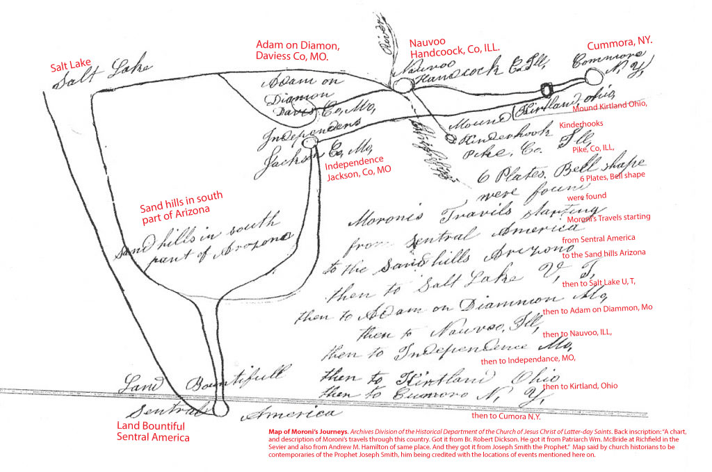
TWO SEPERATE MAPS found in the Church archives and attributed to William McBride (1807-1895) and Andrew M. Hamilton (1809-1894) of Richfield, Utah with the text “got it from Joseph Smith the Prophet” written on it (H. Peterson, 1995) corroborate the above quotes. They closely echo the first Mosiah Hancock quote, by detailing the travels of Moroni “starting in Central America” (see also text on second map). These maps were likely part of the narrative told throughout Southern Utah in the 1880’s by Joseph Smith’s contemporaries concerning his prophesies of the Saints future travels and how they would mirror those of Moroni and the ancient Nephites as per the following quote.
William McBride is recorded giving a detailed explanation of what’s recorded on the maps, at a St George temple prayer meeting in 1881. Charles Lowell records the third-hand words of Joseph Smith in his journal,
Br McBride also related that Joseph marked with his cane in the sand the track the saints would take to the Rocky Mountains. Says Joseph, will you establish the kingdom there? No, but it will be set up and the saints will live their covenants, meaning the Marriage covenant. Said we should travel on thro the mountains; described the Valley of Great Salt Lake just as tho he had lived there, designating where the soldiers camp would be and the burying ground.
Said we should make stations and build up settlements all the way to New and Old Mexico until we crossed the Isthmus and get back to the place where the Covenant was broke [ie. United Order] by the old Nephites. Spoke of the Great Temple in Central America unfinished… This temple was situated by the River Copan anciently called the River of Nephi…
Spoke of the route THE OLD NEPHITES TOOK travelling to Cumorah from the South and Southwest; of having to bury their treasures as they journeyed and finally burying the records and precious things in the Hill Cumorah; of Moroni dedicating the Temple site of what we now call St George, Nauvoo, Jackson Co., Kirtland and others we know not of as yet.
(Diary of Charles Lowell Walker Volume II (26 Jan 1881) (pp. 524–525; PDF pp. 39–40)
Although one could argue as to whether “the old Nephites,” Lowell/McBride were referring to was the whole of the Nephite people or a few survivors with Moroni (as possibly suggested by a Brigham Young quote given around the same date), we will demonstrate it had to be the former as we will demonstrate later in this paper that Joseph Smith absolutely believed the entire Nephite nation met it’s end in upstate New York. It also seems likely from the quote that McBride was following the earlier Times & Seasons articles in considering Copan the city of Nephi, Quirigua the city of Zarahemla and the Copan/Motagua River the ‘River of Nephi’. And although this correlation has since been abandoned by all LDS Book of Mormon geographers because of geographic and dating issues, it once again shows how thoroughly the early saints had been convinced of a continental model. (but not necessarily a hemispheric model!)
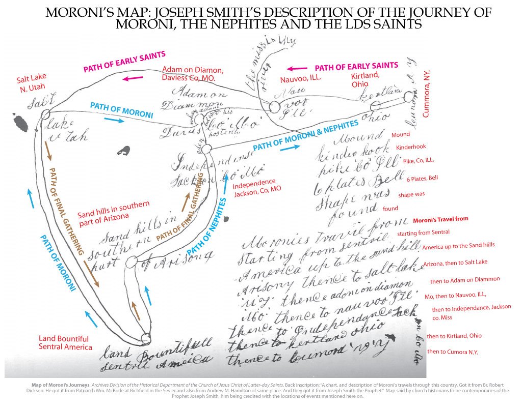
Again, the maps, when combined with Mosiah Hancock’s quote which shares similar verbiage, suggest that the Saints travels out west from New York were a sort of reverse migration from the travels of Moroni and the whole of the Nephite people on their way to Cumorah (which is labeled in New York). A bit more information can be found at this link.
The next day the Prophet came to our home and stopped in our carpenter shop and stood by the turning lathe. I went and got my map for him. “Now”, he said, “I will show you the travels of this people”. He then showed our travels through Iowa, and said, “Here you will make a place for the winter; and here you will travel west until you come to the valley of the Great Salt Lake! You will build cities to the North and to the South, and to the East and to the West; and you will become a great and wealthy people in that land. …But, the United States will not receive you with the laws which God desires you to live, and you will have to go to [the land of Desolation] where the Nephites lost their power. [The Nephites] worked in the United Order for 166 years, and the Saints have got to become proficient in the laws of God before they can meet the Lord Jesus Christ… He said we will not travel the shape of the horse shoe [see map] for there we will await the action of the government. Placing his finger on the map, I should think about where Snowflake, Arizona is situated, or it could have been [northwest?] Mexico, he said, “The government will not receive you with the laws that God designed you to live, and those who are desirous to live the laws of God will have to go South…” [presumably into Mexico] (Mosiah Hancock, Autobiography, BYU Special Collections, Writings of Early Latter-day Saints 28. Original is here, brackets are mine.
Mosiah then clarifies this exodus of the Saints, “South” to Arizona or “Mexico” was not just something that was supposed to happen when Polygamy was outlawed, but a major event in the future of the church occurring when the country breaks into a civil war between the Republicans and Democrats.
those who are desirous to live the laws of God will have to go South. You will live to see men arise in power in the Church who will seek to put down your friends and the friends of our Lord and Savior, Jesus Christ. Many will be hoisted [lifted up] because of their money and the worldly learning which they seem to be in possession of; and many who are the true followers of our Lord and Savior will be cast down because of their poverty. There will be two great political parties in this country. One will be called the Republican, and the other the Democrat party. These two parties will go to war and out of these two parties will spring another party which will be the Independent American Party…. Then the country will go to war, and they will fight… when it’s liberty hangs by a hair, as it were. (Source: continued from above)
The narrative painted by Levi/Mosiah Hancock, and substantiated William McBride and other Joseph Smith contemporaries is clear. They suggest that Joseph taught before his death that the Saints would be chased from Nauvoo to Utah where they would grow to be a large and powerful people. After which they would have to flee back south to Mexico when the Republicans and Democrats went to war, and learn to live the United Order. After which they would retrace the travels of the Nephites and Moroni to return to Independence in Jackson County Missouri and help build the New Jerusalem. This narrative is not just explained in the above quotes but in actual maps found in the Church History archives.
These maps are also corroborated by numerous late dated quotes repeating Brigham Young’s belief that the Manti & St. George temples were dedicated personally by Moroni. Heber C Kimball quoted Brigham in saying “Here [in Manti] is the spot where the prophet Moroni stood and dedicated this piece of land for a Temple site.” (Even the original murals of the Manti temple seem to be telling this same story in the manner Moroni was drawn standing above the Manti Valley.) David Henry Cannon Jr. also quotes Brigham as saying “the brethren.. wanted to move the foundation line [of the St George temple] 12 feet to the south, so that the spring of water would be on the outside of the Temple. ‘Not so,’ replied President Young. ‘We will wall it up and leave it here for some future use, but we cannot move the foundation. This spot was dedicated by the Nephites. They could not build it, but we can and will build it for them.'” There are also quotes made directly by Brigham Young in conferences in St George wherein he said, “the spirits of the Gandiantons were so thick [in the St. George area, because] this is where they lived in these mountains”. Brigham also said in the Salt Lake tabernacle that “the spirits of the Gadiantons are all around us [as] battle-field after battle-field, scattered all over this American continent where the wicked have slain the wicked.”
Before dismissing the quotes just given as too late in time from Brigham & Joseph Smith to be trusted, it’s worth noting that the Nephite migration in the above quotes are not only supported by overwhelming archaeological evidence as presented in the Mexican Highland model, but quite possibly by linguistic evidence of the Uto-Azteca language group as well as general geography matching Book of Mormon land descriptors. In this model the Semitic similarities demonstrated by Brian Stubbs between Uto-Aztecan & Semitic languages would have been first established by the Jaredites who landed in California or Sonora Mexico, and then reinforced by Nephites who later began to migrate into those same regions of Desolation (the Jaredite heartland), and the land Northward. The works of early native chronicler Ixtlilxochitl are also of note.
Although not in any way attributed to Joseph Smith, and in fact in direct contradiction to quotes that are attributed to Joseph Smith when it comes to the location of Desolation, the following quote by Parly P. Pratt given in 1842 helps show that even before the death of the Prophet a number of the Saints were in agreement in holding John Loyyd Stephens Mesoamerican ruins of Quirigua, Copan, Tonina, Uxmal, and Palenque as Book of Mormon cities. (Desolation cities in the minds of both Parley P Pratt & Orson Pratt.)
I say it is remarkable that Mr. Smith, in translating the Book of Mormon from 1827 to 1830, should mention the names and circumstances of those towns and fortifications in this very section of country, where a Mr. Stephens, ten years afterwards, penetrated a dense forest, till then unexplored by modern travelers, and actually finds the ruins of those very cities mentioned by Mormon. The nameless nation of which he speaks were the Nephites. The lost record for which he mourns is the Book of Mormon. The architects, orators, statesmen, and generals, whose works and monuments he admires, are, Alma, Moroni, Helaman, Nephi, Mormon, and their contemporaries. The very cities whose ruins are in his estimation without a name, are called in the Book of Mormon, “Teancum, Boaz, Jordan, Desolation,” &c.
Parley P. Pratt, “Ruins in Central America,” Millennial Star, March 1842, 165. (source link)
(4) –Quotes suggesting Joseph believed Cumorah and the final battle to be in New York, and much of North America to be the Book of Mormon ‘Land Northward’.
In addition to the Times & Seasons articles showing correlations between Mesoamerican ruins and the Book of Mormon, the first article of the series in May 1842 showed correlations between mummies found in Kentucky and the Book of Mormon. Suggesting the author of the Times & Season’s articles quoted above, believed a continental model with parts of the Book of Mormon occurring in the eastern US, in addition to Mesoamerica. In the article, the author states,
Had Mr. Ash in his researches consulted the Book of Mormon his problem would have been solved, and he would have found no difficulty in accounting for the [kentucky] mummies being found in the above mentioned case. The Book of Mormon gives an account of a number of the descendants of Israel coming to this continent; and it is well known that the art of embalming was known among the Hebrews, as well as among the Egyptians.
Times and Seasons, 2 May. 1842, vol. 3, no. 13, pp. 781 edited by JS.
Of course this should be obvious from Joseph’s many references to the tradition Hill Cumorah in New York being the same as the one mentioned in the Book of Mormon where the final battle occurred. An epistle from Joseph Smith the Prophet to the church, dated at Nauvoo, Illinois, September 6, 1842. Shows explicitly that Joseph believed the location where Moroni appeared before giving him the plates was called Cumorah (ie. The one mentioned in the Book of Mormon).
Now, what do we hear in the gospel which we have received? A voice of gladness! A voice of mercy from heaven; and a voice of truth out of the earth; glad tidings for the dead; a voice of gladness for the living and the dead; glad tidings of great joy. How beautiful upon the mountains are the feet of those that bring glad tidings of good things, and that say unto Zion: Behold, thy God reigneth! As the dews of Carmel, so shall the knowledge of God descend upon them!
And again, what do we hear? Glad tidings from Cumorah! Moroni, an angel from heaven, declaring the fulfilment of the prophets-the book to be revealed. A voice of the Lord in the wilderness of Fayette, Seneca county, declaring the three witnesses to bear record of the book! The voice of Michael on the banks of the Susquehanna, detecting the devil when he appeared as an angel of light! The voice of Peter, James, and John in the wilderness between Harmony, Susquehanna county, and Colesville, Broome county, on the Susquehanna river, declaring themselves as possessing the keys of the kingdom, and of the dispensation of the fulness of times! (D&C 128:19–20)
Only incredible feats of mental gymnastics can deny that the above canonized letter from Joseph Smith in 1842 is calling the hill in New York where Moroni appeared to Joseph Smith Cumorah. (Just as it is saying Michael appeared on the Susquehanna & Peter, James & John appeared near Harmony Penn.
Still, many proponents of the limited Mesoamerican Book of Mormon model like to suggest that the above quote does not prove Joseph believed (or revelation dictates) that Cumorah was in New York. So let’s go through a few other second hand sources to make that denial even more implausible. As the following letter written by Oliver Cowdery in 1835 makes it clear that he believed the Cumorah of the Book of Mormon and that of New York to be the same. And portions of this same letter were used in Joseph Smith’s official history. Much like the unlikely argument that Joseph was completely unaware of the Times & Seasons articles explicitly pointing to Mesoamerica in relation to the lands of Nephi & Zarahemla, surely Joseph would have corrected this gross misunderstanding had he believed Oliver was completely missing the boat on the correct location of Cumorah.
“In my last I said I should give, partially, a “description of the place where, and the manner in which these records were deposited… the hill of which I have been speaking…where the record was found to be deposited, on the west side of the hill, not far from the top down its side; and when myself visited the place in the year 1830…”
(Handwriting of Oliver Cowdery, Shares page with dictated ‘Joseph Smith History’. Joseph Smith Papers, Letter VII” Oct. 1835)
“You are acquainted with the mail road from Palmyra… At about one mile west rises another ridge of less height, running parallel with the former, leaving a beautiful vale between. The soil is of the first quality for the country, and under a state of cultivation, which gives a prospect at once imposing, when one reflects on the fact, that here, between these hills, the entire power and national strength of both the Jaredites and Nephites were destroyed. By turning to the 529th and 530th pages of the book of Mormon you will read Mormon’s account of the last great struggle of his people, as they were encamped round this hill Cumorah”
Lucy Mack Smith echoed this same belief in her history written in 1844. Surely if Joseph had believed Cumorah to be in Mesoamerica, Lucy would have known not to misrepresent Joseph so blatantly.
“[Moroni, after telling Joseph about the record, said] but you cannot get it until you learn to keep the commandments of God For it is not to get gain. But it is to bring forth that light and intelligence which has been long lost in the Earth…
(JSP Lucy Mack Smith, History, 1844–1845)
The record is on a side hill on the Hill of Cumorah 3 miles from this place. Remove the grass and moss and you will find a large flat stone pry that up and you will find the record under it laying on 4 pillars of cement— then the angel left him.”
In 1856 Heber C. Kimball gave a talk in which he gave suggested first or possibly second hand information about a vision that “Joseph [Smith] and others had” concerning the Hill Cumorah in New York. This vision gave information to them about a cave in which was stored “all the sacred engravings” or as was seen in this vision, “more records than ten men could carry”.
“…the vision that Joseph [Smith] and others had, when into a cave in the hill Cumorah, and saw more records than ten men could carry…. There were books piled up on tables, book upon book. …they are events that I heard Joseph speak of, time and time again.
(Heber C Kimball. Journal of Discourses Vol.4, Page 105)
This experience is shared by at least 9 different individuals, who heard about, mostly second hand. Although all the quotes are of a late date they at least seem to corroborate the general experience even though they vary on important details such as 1. who was there, 2, whether the experience was objective or a subjective visionary experience, and 3, what exactly was in the cave. For all 9 or 10 accounts see Cumorah’s Cave by Cameron j. Packer or this article on supportingevidences.net
In this article we offer two more quotes because one tells who might have been there, and the other is a first hand source by one of those individuals. The first by William Horne Dame, 1819-1884, was written in his Diary dated, 14 January 1855.
“Attended meeting a discourse from W. W. Phelps. He related a story told him by Hyrum Smith which was as follows: Joseph, Hyrum, Cowdery & Whitmere went to the hill Cormorah. As they were walking up the hill, a door opened and they walked into a room about 16 ft square. In that room was an angel and a trunk. On that trunk lay a book of Mormon & gold plates, Laban’s sword, Aaron’s brestplate.” (William Horne Dame Diary, 14 January 1855)
The second quote was recorded incredibly late (at least 50 years later) in 16 August 1878, by Whitmer himself speaks about the record cave of Cumorah, as if he had intimate knowledge of it, but not saying specifically that he had been there, in an interview with P. Wilhelm Poulson of the Deseret News:
Poulson: Where are the plates now?
Whitmer: In a cave, where the angel has hidden them up till the time arrives when the plates, which are sealed, shall be translated. God will yet raise up a mighty one, who shall do his work till it is finished and Jesus comes again.
Poulson: Where is that cave?
Whitmer: In the State of New York.
Poulson: In the Hill of Comorah?
Whitmer: No, but not far away from that place.
(John Whitmer. Deseret Evening News, August 16, 1878. See more info here)
Recollections of a conversation with Joseph Smith by his mother, Lucy Mack Smith. Shows that the Hill Cumorah was in the New York area.
The fact was I had learned to be a little cautious about matters with regard to Joseph, for I was accustomed to see him look as he did on that occasion and I could not easily mistake the cause thereof.
(Lucy Mack Smith, History of Joseph Smith by His Mother [Salt Lake City: Stevens & Wallis, Inc., 1945], 100.)
Presently he smiled and said in a calm tone, “I have taken the severest chastisement that I have ever had in my life.”
My husband, supposing that it was from some of the neighbors, was quite angry and observed, “I would like to know what business anybody has to find fault with you!”
“Stop, father, stop,” said Joseph, “it was the angel of the Lord. As I passed by the hill of Cumorah, where the plates are, the angel met me and said that I had not been engaged enough in the work of the Lord; that the time had come for the record to be brought forth; and that I must be up and doing and set myself about the things which God had commanded me to do. But, father, give yourself no uneasiness concerning the reprimand which I have received, for I now know the course that I am to pursue, so all will be well.”
It was also made known to him at this interview that he should make another effort to obtain the plates, on the twenty-second of the following September, but this he did not mention to us at that time.
Remember that the Book of Mormon explicitly states that the final Battle happened around the Hill Cumorah and that the location where “all the records” were hid was called the Hill Cumorah. So to suggest the revelation of D&C 128:20 and that in the above quotes are not the same as the hill mentioned in the Book of Mormon, is to suggest there are TWO Hill Cumorahs, and that Joseph was deeply mistaken and that the D&C 128 revelation/letter was not specifically inspired in regard to the name of the location therein referred.
2 And I, Mormon, wrote an epistle unto the king of the Lamanites, and desired of him that he would grant unto us that we might gather together our people unto the land of Cumorah, by a hill which was called Cumorah, and there we could give them battle.
6 And it came to pass that when we had gathered in all our people in one to the land of Cumorah, behold I, Mormon, began to be old; and knowing it to be the last struggle of my people, and having been commanded of the Lord that I should not suffer the records which had been handed down by our fathers, which were sacred, to fall into the hands of the Lamanites, (for the Lamanites would destroy them) therefore I made this record out of the plates of Nephi, and hid up in the hill Cumorah all the records which had been entrusted to me by the hand of the Lord, save it were these few plates which I gave unto my son Moroni. (Mormon 6:2,6)
.
(5) – Quotes Concerning Nephites/Lamanites Living in the United States Region & Central US Natives Being Descendants of the Book of Mormon Peoples
Joseph Smith specifically stated the Book of Mormon was written by the forefathers of the western tribes (likely referring to the Natives west of Nauvoo, which included the Cherokee and natives relocated in the Indian Removal Act to Oklahoma territory in the 1830’s). Note he does not say the tribes of the East or South or Mexico, but particular singles out those of the West.
The Book of Mormon is a record of the forefathers of our western Tribes of Indians, having been found through the ministration of an holy Angel translated into our own Language by the gift and power of God, after having been hid up in the earth for the last fourteen hundred years31 containing the word of God, which was delivered unto them, By it we learn that our western tribes of Indians are desendants from that Joseph that was sold into Egypt, and that the Land of America is a promised land unto them,32 and unto it all the tribes of Israel will come. with as many of the gentiles as shall comply with the requesitions of the new co[v]enant.
Joseph Smith Letter, Kirtland Township, OH, to Noah C. Saxton, Rochester, Monroe Co., NY, 4 Jan. 1833
From the Wentworth Letter–shows that Moroni instructed Joseph on many aspects relating to Book of Mormon geography.
On the evening on the 21st of September, A.D. 1823, while I was praying unto God, and endeavoring to exercise faith in the precious promises of Scripture, on a sudden a light like that of day, only of a far purer and more glorious appearance and brightness, burst into the room, indeed the first sight was as though the house was filled with consuming fire; the appearance produced a shock that affected the whole body; in a moment a personage stood before me surrounded with a glory yet greater than that with which I was already surrounded. This messenger proclaimed himself to be an angel of God, sent to bring the joyful tidings that the covenant which God made with ancient Israel was at hand to be fulfilled, that the preparatory work for the second coming of the Messiah was speedily to commence; that the time was at hand for the Gospel in all its fullness to be preached in power, unto all nations that a people might be prepared for the Millennial reign. I was informed that I was chosen to be an instrument in the hands of God to bring about some of His purposes in this glorious dispensation.
I was also informed concerning the aboriginal inhabitants of this country and shown who they were, and from whence they came; a brief sketch of their origin, progress, civilization, laws, governments, of their righteousness and iniquity, and the blessings of God being finally withdrawn from them as a people, was made known unto me; I was also told where were deposited some plates on which were engraven an abridgment of the records of the ancient Prophets that had existed on this continent. The angel appeared to me three times the same night and unfolded the same things. After having received many visits from the angels of God unfolding the majesty and glory of the events that should transpire in the last days, on the morning of the 22nd of September, A.D. 1827, the angel of the Lord delivered the records into my hands.
…In this important and interesting book the history of ancient America is unfolded, from its first settlement by a colony that came from the Tower of Babel, at the confusion of languages to the beginning of the fifth century of the Christian Era. We are informed by these records that America in ancient times has been inhabited by two distinct races of people. The first were called Jaredites, and came directly from the Tower of Babel. The second race came directly from the city of Jerusalem, about six hundred years before Christ. They were principally Israelites, of the descendants of Joseph. The Jaredites were destroyed about the time that the Israelites came from Jerusalem, who succeeded them in the inheritance of the country. The principal nation of the second race fell in battle towards the close of the fourth century. The remnant are the Indians that now inhabit this country. This book also tells us that our Savior made His appearance upon this continent after His resurrection; that He planted the Gospel here in all its fulness, and richness, and power, and blessing; that they had Apostles, Prophets, Pastors, Teachers, and Evangelists; the same order, the same priesthood, the same ordinances, gifts, powers, and blessings, as were enjoyed on the eastern continent, that the people were cut off in consequence of their transgressions, that the last of their prophets who existed among them was commanded to write an abridgment of their prophecies, history, &c, and to hide it up in the earth, and that it should come forth and be united with the Bible for the accomplishment of the purposes of God in the last days. For a more particular account I would refer to the Book of Mormon, which can be purchased at Nauvoo, or from any of our Traveling Elders.
(Joseph Smith. Wentworth Letter. JS, History, 1838–1856, vol. C-1, created 24 Feb. 1845–3 July 1845; handwriting of Thomas Bullock, Franklin D. Richards, Jonathan Grimshaw, and Leo Hawkins; 512 pages. Original available here)
Revelation given through Joseph Smith the Prophet to Oliver Cowdery, at Fayette, New York, September 1830. Calls Native Americans in North Central America “Lamanites.”
And now, behold, I say unto you that you shall go unto the Lamanites and preach my gospel unto them; and inasmuch as they receive thy teachings thou shalt cause my church to be established among them; and thou shalt have revelations, but write them not by way of commandment.
And now, behold, I say unto you that it is not revealed, and no man knoweth where the city Zion shall be built, but it shall be given hereafter. Behold, I say unto you that it shall be on the borders by the Lamanites. [of the Kansas/Oklahoma Territory, relocated there in 1830, see this link](D&C 28:8–9)
Revelation given through Joseph Smith the Prophet to Parley P. Pratt and Ziba Peterson, October 1830. Calls Native Americans in North Central America “Lamanites.”
And that which I have appointed unto him is that he shall go with my servants, Oliver Cowdery and Peter Whitmer, Jun., into the wilderness among the Lamanites. [of the Kansas/Oklahoma Territory, relocated there in 1830, see this link](D&C 32:2)
Revelation given through Joseph Smith the Prophet to Newel Knight, at Kirtland, Ohio, June 1831. Calls Native Americans in North Central America “Lamanites.”
And thus you shall take your journey into the regions westward, unto the land of Missouri, unto the borders of the Lamanites. [of the Kansas/Oklahoma Territory, relocated there in 1830, see this link](D&C 54:8)
Entry in The History of the Church showing that Nephites and Lamanites lived in the Illinois area (where Joseph Smith was traveling with Zion’s Camp).
During our travels we visited several of the mounds which had been thrown up by the ancient inhabitants of this country-Nephites, Lamanites, etc., and this morning I went up on a high mound, near the river, accompanied by the brethren. From this mound we could overlook the tops of the trees and view the prairie on each side of the river as far as our vision could extend, and the scenery was truly delightful.
Apparently assembled from the accounts of Heber C Kimball & Wilford Woodruff. Joseph Smith, History of The Church of Jesus Christ of Latter-day Saints, 7 vols., introduction and notes by B. H. Roberts [Salt Lake City: The Church of Jesus Christ of Latter-day Saints, 1932-1951], 2: 79 – 80
On the top of the mound were stones which presented the appearance of three altars having been erected one above the other, according to the ancient order; and the remains of bones were strewn over the surface of the ground. The brethren procured a shovel and a hoe, and removing the earth to the depth of about one foot, discovered the skeleton of a man, almost entire, and between his ribs the stone point of a Lamanitish arrow, which evidently produced his death. Elder Burr Riggs retained the arrow. The contemplation of the scenery around us produced peculiar sensations in our bosoms; and subsequently the visions of the past being opened to my understanding by the Spirit of the Almighty, I discovered that the person whose skeleton was before us was a white Lamanite, a large, thick-set man, and a man of God. His name was Zelph. He was a warrior and chieftain under the great prophet Onandagus, who was known from the Hill Cumorah, or eastern sea to the Rocky mountains. The curse was taken from Zelph, or, at least, in part-one of his thigh bones was broken by a stone flung from a sling, while in battle, years before his death. He was killed in battle by the arrow found among his ribs, during the last great struggle of the Lamanites and Nephites.
Entry in The History of the Church showing that Nephites and Lamanites lived near Adam-ondi-Ahman in North Central America.
Saturday, 19.-This morning we struck our tents and formed a line of march, crossing Grand River at the mouth of Honey Creek and Nelson’s Ferry. Grand River is a large, beautiful, deep and rapid stream, during the high waters of Spring, and will undoubtedly admit of navigation by steamboat and other water craft. At the mouth of Honey Creek is a good landing. We pursued our course up the river, mostly through timber, for about eighteen miles, when we arrived at Colonel Lyman Wight’s home. He lives at the foot of Tower Hill (a name I gave the place in consequence of the remains of an old Nephite altar or tower that stood there), where we camped for the Sabbath.
Joseph Smith, History of The Church of Jesus Christ of Latter-day Saints, 7 vols., introduction and notes by B. H. Roberts [Salt Lake City: The Church of Jesus Christ of Latter-day Saints, 1932-1951], 3: 34
See “Joseph Smith and the Question of Book of Mormon Geography” by Matthew Roper for arguments for/against a Central/eastern American setting..
.
Quotes regarding Joseph Smith’s ‘vision’ of Zelph and the final battle, as well as confirmation that the Nephites & Jaredites spread across North America from sea to sea.
In multiple quotes directly attributed to Joseph Smith in the official history of the church Zelph is described in ways that make holding to a purely Mesoamerican final battle or 2 Cumorah model incredibly difficult. Zelph’s location is stated in a letter from Joseph to Emma as occurring in “the plains of the Nephites”. The accounts of Zelph are specifically attributed to a “vision”. Joseph states his death occurred “during the last great struggle of the Lamanites and Nephites”. His fame was known “from the Hill Cumorah, or eastern sea to the Rocky mountains”. Those who try to dismiss Zelph as being some lone Nephite survivor of the final battle who wandered 2000 miles north of Vera Cruz, Mexico after the final battle (despite Mormon 6:15 saying those who escaped went south) must make mental gymnastic leaps of logic which discount not only the direct quotes concerning Zelph himself, but also the corpus of other quotes given above in this paper.
all the [Zions] Camp is in as good a situation as could be expected; but our numbers and means are altogether too small for the accomplishment of such a great enterprise… The whole of our journey, in the midst of so large a company of social honest men and sincere men, wandering over the plains of the Nephites, recounting occasionaly the history of the Book of Mormon, roving over the mounds of that once beloved people of the Lord, picking up their skulls & their bones, as a proof of its divine authenticity, and gazing upon a country the fertility, the splendour and the goodness…
Letter to Emma Smith, 4 June 1834
See ‘Zelph Revisited’ section below for all available details on Zelph
Archaeological Evidence and Mesoamerican Skeptics of The Zelph Mound
It’s common for Mesoamerican Book of Mormon model proponents to dismiss the Zelph evidence or try to make the story of Zelph fit into a “2 Cumorah model” by dishonestly appealing to archaological dates of Naples-Russell Mound Number 8. For those who attempt this I ask, do you not see how you’re doing the same thing Heartlanders do when they use mental gymnastics to explain away Joseph’s quotes on a Mesoamerican setting? If you fall in this camp let me clearly and sequentially lay out the logic and evidence that you must be missing.
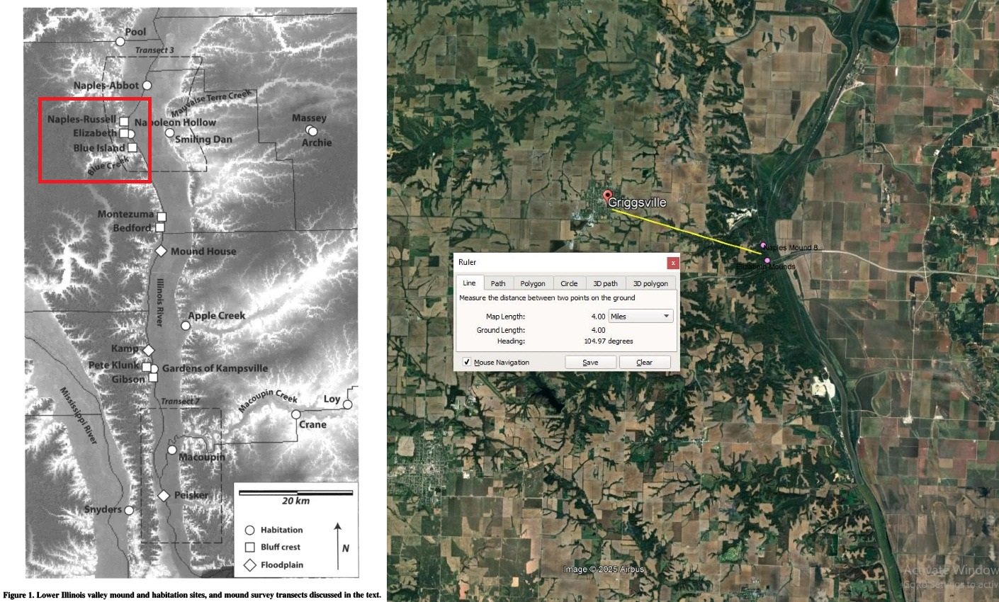
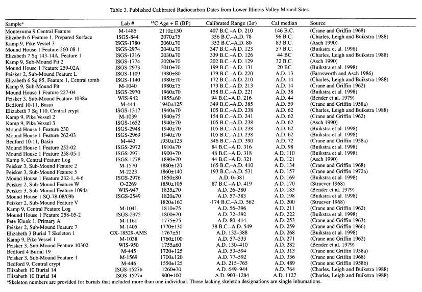
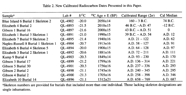
1. First for those who claim the radiocarbon dating of Naples-Russell Mound Number 8 in Pike County precludes Zelph from being a general in the final Nephite battle — you are using poor logic or bad information. Expressly because we can’t be certain that Naples-Russell Mound Number 8 is mound which Zelph was in! Almost ALL who make this argument fail to realize that there ARE MANY mound groups which match the historical accounts of being “on the west side [of the Illinois River]… about a mile below the crossing” (see both the Levi Hancock Journal and the Times & Seasons account and Willard Richards account or Heber C Kimball account of the mounds location). As you can see from the archaeological site map below, not only are there a half dozen mound groups on the “east side” of the Illinois River in the region, but there are TWO mound groups within a few hundred yards of each other at the Naples-Russell Mound site. Indeed the Elizabeth Mound group contained up to 14 burials dating from 96 BC to 1127 AD!!! (see radiocarbon chart from excavation papers in the image below).
Moreover, critics forget that in the historical records it states that “On the top of the mound were stones which presented the appearance of three alters having been erected one above the other and… human bones were strewn over the surface of the ground. The brethren procured a shovel and hoe, and removing the earth to the depth of about one foot discovered skeleton of a man”. This does not match the logic of Naples-Russell Mound excavations which found “disturbances”, ‘half way down the mound’ (which later LDS authors have assumed were from Joseph Smith’s party.
But his does not make sense, since Naples-Russell Mound excavations found a wood tomb which is NOT mentioned in the Joseph Smith account. It therefor seems MORE likely that it was the Elizabeth mound group (or some other) which they actually dug into. However, even if by some chance it was the Naples-Russell Mound which Joseph’s party dug into, at a foot deep (as their record claims) they would have been ABOVE the QL-4904 log tomb cap likely at area which had been eroded by the time professional excavations took place a hundred years later. (see King, 2017; Farnsworth, 2019; & Farnsworth 2020). Note that Wilford Woodruff recounts that they took the thigh bone home (which was just one of “the bones were strewn over the surface”). So the chances that any skeletal remains of Zelph, or even his entire internment layer remained at the time of professional excavation is low. (https://bhroberts.org/records/b1mDub-GfvQjc/ww_records_the_discovery_of_zelph).
(Images are from King et al, “Time and Archaeological Traditions in the Lower Illinois Valley“. American Antiquity. 76 (3): 2011, p.500–528. Of specific interest is the Elizabeth site found only a few hundred yards from the Russel site with burials ranging from 74 BC to 687 AD.)
2. To attempt to dismiss Zelph as some type of pre-final battle Nephite who wandered up into Illinoise while holding to a two-Cumorah geography where the Land Northward is Veracruz, one must dismiss nearly every aspect of the historical accounts of Joseph Smith’s vision.
https://bhroberts.org/records/b1mDub-7NKSMb/mh_official_account_about_zelph_discovery
You also have to dismiss the Heber C. Kimball bit that says Zelph was “an officer who fell in battle, in the last destruction among the Lamanites”
https://bhroberts.org/records/b1mDub-uN8Ixc/hck_recalls_when_they_found_zs_remains
You also have to dismiss WW details, because he says that the prophet said “onandagus, who was known from the Hill Cumorah, or eastern sea to the Rocky mountains”.
Do you see there that he equates Cumorah with New England?! So again we must suppose that detail was unprophetic and not part of the vision.
https://www.josephsmithpapers.org/paper-summary/history-1838-1856-volume-a-1-23-december-1805-30-august-1834/489
https://catalog.churchofjesuschrist.org/assets/14079217-b2a7-4eff-8b53-1be6c1e9bea5/0/23
Do you see the bottomless rationalizations? We have to ‘explain away’ the whole plains of the Nephites quote. And none of this even begins to start on the quotes concerning a New England Cumorah. (and the visionary character to some of those quotes). Either believe Joseph was prophet in his ideas on BOM Geography or dont. Maybe he was clueless. Fine. Just dont pretend the zelph documentary evidence supports 2 cumorah’s WHEN IT ABSOLUTELY DOES NOT. Most people on this forum don’t care. But we should care about intellectual honesty and logic.
You can’t point at Heartlanders for their foolishness of dismissing all the times & seasons articles as “not actually from Joseph” and then turn around and do the same thing, and then expect people not to see you as just as intellectually dishonest as them. take my honest critique for what its worth.
Zelph Revisited
Text of ‘Zelph Revisited’, by Donald Q. Cannon, Church History Regional Studies, BYU Department of Church History and Doctrine, Regional Studies, Illinois. PDF available here.
[Although] most Latter-day Saints would not recognize the name Zelph. However, serious students of LDS Church history and Book of Mormon geography would likely know Zelph as the white Lamanite whose remains were found by Zion’s Camp as they traveled through central Illinois.
The name Zelph first appears in LDS history in connection with Zion’s Camp. The most familiar version of the story
is in the History of the Church [written around 1843 written by James Mulholland, WW Phelps & Willard Richards]. The story of Zelph from that source follows:
Our enemies had threatened that we should not cross the Illinois river, but on Monday the 2nd we were ferried over without any difficulty. The ferryman counted, and declared there were five hundred of us, yet our true number was only about one hundred and fifty. Our company had been increased since our departure from Kirtland by volunteers from different branches of the Church through which we had passed. We encamped on the bank of the river until Tuesday the 3rd.
During our travels we visited several of the mounds which had been thrown up by the ancient inhabitants of this country-Nephites, Lamanites, etc., and this morning I went up on a high mound, near the river, accompanied by the brethren. From this mound we could overlook the tops of the trees and view the prairie on each side of the river as far as our vision could extend, and the scenery was truly delightful.
On the top of the mound were stones which presented the appearance of three altars having been erected one above the other, according to the ancient order; and the remains of bones were strewn over the surface of the ground. The brethren procured a shovel and a hoe, and removing the earth to the depth of about one foot, discovered the skeleton of a man, almost entire, and between his ribs the stone point of a Lamanitish arrow, which evidently produced his death. Elder Burr Riggs retained the arrow. The contemplation of the scenery around us produced peculiar sensations in our bosoms; and subsequently the visions of the past being opened to my understanding by the Spirit of the Almighty, I discovered that the person whose skeleton was before us was a white Lamanite, a large, thick-set man, and a man of God. His name was Zelph. He was a warrior and chieftain under the great prophet Onandagus, who was known from the Hill Cumorah, or eastern sea to the Rocky mountains. The curse was taken from Zelph, or, at least, in part-one of his thigh bones was broken by a stone flung from a sling, while in battle, years before his death. He was killed in battle by the arrow found among his ribs, during the last great struggle of the Lamanites and Nephites.
History, 1838–1856, volume A-1 [23 December 1805–30 August 1834] Note that the “‘or eastern sea”, although a supratext is indeed part of the original journal entry here.
The primary source material for the Zelph story comes from diaries kept by some members of Zion’s Camp.2 Six men wrote diary accounts concerning Zelph: Wilford Woodruff, Heber C. Kimball, George A. Smith, Levi Hancock, Moses Martin, and Reuben McBride.
What do these six contemporary accounts tell us about Zelph? The answer to that question is based upon a careful analysis of the primary sources. Each diary account is reproduced herein as it appeared in the original, without changes in spelling or grammar. Following the printed text of each diary account is a paragraph summarizing the account and including my own interpretations.
Wilford Woodruff, who was the preeminent LDS journal-keeper of the entire nineteenth century, prepared a characteristically detailed record of the events surrounding the discovery of Zelph. Woodruff’s reputation and stature is further attested to by his decade of church service as a member of the Quorum of the Twelve and as president of the Church during a crucial period in its history. His journal entry about his experience in Zion’s Camp under the date May-June 1834 follows:
While on our travels we visited many of the mounds which were flung up by the ancient inhabitants of this continent probably by the Nephites & Lamanites. We visited one of those Mounds and several of the brethren dug into it and took from it the bones of a man.
We visited one of those Mounds: considerd to be 300 feet above the level of the Illinois river. Three persons dug into the mound & found a body. Elder Milton Holmes took the arrow out of the back bones that killed Zelph & brought it with some of the bones in to the camp. I visited the same mound with Jesse J. Smith. Who the other persons were that dug in to the mound & found the body I am undecided.
Brother Joseph had a vission respecting the person. He said he was a white Lamanite. The curs was taken from him or at least in part. He was killed in battle with an arrow. The arrow was found among his ribs. One of his thigh bones was broken. This was done by a stone flung from a sling in battle years before his death. His name was Zelph. Some of his bones were brought into the Camp and the thigh bone which was broken was put into my waggon and I carried it to Missouri. Zelph was a large thick set man and a man of God. He was a warrior under the great prophet /Onandagus/ that was known from the hill Camorah /or east sea/ to the Rocky mountains. The above knowledge Joseph receieved in a vision. 3 (link to original)
Wilford Woodruff tells us that these mounds were probably built by the Nephites and Lamanites. He also records that Joseph had a vision concerning the skeleton, learning that he was a white Lamanite, who had been killed in battle. His name was Zelph, “a large thick-set man and a man of God, he was a warrior under the great prophet that was known from the Hill Cumorah to the Rocky Mountains.”
Heber C. Kimball’s journal has a good reputation, a fact supported by the numerous times it has been published, both in extracts and in book form. The Zelph episode is found in one of these published versions in the Times and Seasons under the title “Extracts from H. C. Kimball’s Journal.” His comments on Zelph include the following:
On Tuesday the 3rd, we went up, several of us, with Joseph Smith jr. to the top of a mound on the bank of the Illinois river, which was several hundred feet above the river, and from the summit of which we had a pleasant view of the surrounding country: we could overlook the tops of the trees, on to the meadow or prairie on each side the river as far as our eyes could extend, which was one of the most pleasant scenes I ever beheld. On the top of this mound there was the appearance of three altars, which had been built of stone, one above another, according to the ancient order; and the ground was strewn over with human bones. This caused in us very peculiar feelings, to see the bones of our fellow creatures scattered in this manner, who had been slain in ages past. We felt prompted to dig down into the mound, and sending for a shovel and hoe, we proceeded to move away the earth. At about one foot deep we discovered the skeleton of a man, almost entire; and between two of his ribs we found an Indian arrow, which had evidently been the cause of his death. We took the leg and thigh bones and carried them along with us to Clay county. All four appeared sound. Elder B. Young has yet the arrow in his possession. It is a common thing to find bones thus drenching upon the earth in this country.
The same day, we pursued our journey.-While on our way we felt anxious to know who the person was who had been killed by that arrow. It was made known to Joseph that he had been an officer who fell in battle, in the last destruction among the Lamanites, and his name was Zelph. This caused us to rejoice much, to think that God was so mindful of us as to show these things to his servant. Brother Joseph had enquired of the Lord and it was made known in a vision. 4 (link to original)
From Heber C. Kimball’s account we learn that several men went with Joseph Smith to visit the mound, which was several hundred feet above the Illinois River. He tells of altars being located on top of the mound. They discovered a human skeleton about one foot below the surface. There was an Indian arrow between his ribs. He said that Brigham Young had the arrow in his possession.
George A. Smith’s church experience was similar to that of Woodruff and Kimball. He served as a member of the Quorum of the Twelve and as a counselor in the First Presidency. He is known as a reliable witness. He recorded the event in his journal; however, the text which follows was prepared later in connection with the History of the Church: “Monday, 2 June 1834: Some of us visited a mound on a bluff about 300 feet high and dug up some bones, which excited deep interest among the brethren. The President and many others visited the mound on the following morning.”5
The record from George A. Smith is much shorter than the other accounts. He gives the full date (Monday, June 2, 1834), tells of the height of the mound, and indicates Joseph Smith visited the mound the following morning.
Another Church leader, Levi Hancock, served as one of the presidents of the Seventy. His account is the most detailed and complete of any of the six accounts. His diary is regarded as a reliable and accurate source for events he experienced.
On the way to Illinois River where we camped on the west side in the morning, many went to see the big mound about a mile below the crossing, I did not go on it but saw some bones that was brought with a broken arrow, they was layed down by our camp Joseph addressed himself to Sylvester Smith, “This is what I told you and now I want to tell you that you may know what I meant; this land was called the land of desolation and Onendagus was the king and a good man was he, there in that mound did he bury his dead and did not dig holes as the people do now but they brought there dirt and covered them untill you see they have raised it to be about one hundread feet high, the last man buried was Zelf, he was a white Lamanite who fought with the people of Onendagus for freedom, when he was young he was a great warrior and had his th[igh] broken and never was set, it knited together as you see on the side, he fought after it got strength untill he lost every tooth in his head save one when the Lord said he had done enough and suffered him to be killed by that arrow you took from his brest.” These words he said as the camp was moving of[f] the ground; as near as I could learn he had told them something about the mound and got them to go and see for themselves. I then remembered what he had said a few days before while passing many mounds on our way that was left of us; said he, “there are the bodies of wicked men who have died and are angry at us; if they can take the advantage of us they will, for if we live they will have no hope.” I could not comprehend it but supposed it was all right. 6
From Levi Hancock we learn some things previously known as well as some new information. Hancock identifies the Illinois River and says they were camped on the west side of the river. Further, he says the mound was a mile below the crossing, i.e., south [p.101] of the ferry. Following a vision, Joseph told the members of the camp, especially Sylvester Smith, about the bones. He told them this was the Land of Desolation and that Onandagus was their king. Zelph was a white Lamanite who fought for freedom. This mighty warrior was killed by an arrow.
Moses Martin, who was on site when the skeleton was excavated, wrote the following:
This being in the Co of Pike, here we discovered a large quantity of large mounds. Being filed with curiosity we excavated the top of one so[m]e 2 feete when we came to the bones of an extraordinary large person or human being, the thigh bones being 2 inches longer from one Socket to the other than of the Prophet \whi\ who is upwards of 6 feete high which would have constuted some 8 or 9 feete high. In the trunk of this skeleton near the vitals we found a large stone arrow which I suppose brougt him to his end. Soon after this Joseph had a vision and the Lord shewed him that this man was once a mighty Prophet and many other things concerning his people. Thus we found those mounds to have be[en] deposits for the dead which had falen no doubt in some great Batles. In addition to this we found many large fortifications which als[o] denotes siviliseation and an innumberable population which has falen by wars and comotion and the Banks of this Beautiful River became the deposit of many hundred thousands whose graves and fortifications \have\ are overgrown with the sturdy oak 4 feete in diameter. 7 (link to original)
From Moses Martin the following is reported. They were in Pike County, and there were several large mounds. He furnishes details such as the excavation being two feet deep, the skeleton being extra large. He estimated the skeleton to be eight or nine feet tall because of the size of the thigh bone. There was a stone arrow in his rib cage. Joseph had a vision concerning the event and learned that this was a mighty prophet. These mounds were graves for the dead who had fallen in great battles.
Reuben McBride’s account is important because it was written close to the time of the event. It is, however, somewhat confusing because the information on Zelph is written in two different parts of his journal. In order to clarify the meaning, the entries relating to Zelph have been compressed together and the intervening, extraneous information has been deleted.
Tuesday 3 visited the mounds. A skeleton was dug up. Joseph, said his name was Zelph a great warrior under the Prophet Omandagus. An arrow was found in his Ribs which he said he suposed ocaisoned his death \Said\ he was killed in battle. Said he was a man of God and the curse was taken off or in part he was a white Lamanite was known from the atlantic to the Rocky Mountains. 8 (link to original)
From Reuben McBride we learn that the date was Tuesday, the third, when they visited the mounds. They dug up a skeleton and Joseph identified the remains as Zelph, a warrior under the prophet Onandagus.
What do these six contemporary accounts tell us about Zelph and Book of Mormon geography? In order to answer this question, I will present the following summary containing the basic facts followed by the sources of information in parentheses. A key to abbreviations is also included.
SUMMARY
Key to Abbreviations:
GAS/GS = George A. Smith
HCK/HK = Heber C. Kimball
LH = Levi Hancock
MM = Moses Martin
RM = Reuben McBride
WW = Wilford Woodruff
Dates of Visits to Mounds
Group: Monday, June 2, 1834 (GAS), J. Smith: Tuesday, June 3, 1834 (HCK, RM) May-June 1834 (WW)
| Detail (below) – Quote Author (right) | GS | HK | LH | MM | RM | WW |
| Place Where Mounds are Located | ||||||
| Illinois River (WW, HCK, LH) | X | X | X | |||
| Pike County (MM) | X | |||||
| Description of Mounds | ||||||
| 300 feet above River (WW, GAS) | X | X | ||||
| Flung up by ancient inhabitants (WW) | X | |||||
| Several hundred feet above River (HCK) | X | |||||
| Three alters on top of Mound (HCK) | X | |||||
| Big Mound (LH) | X | |||||
| Large Quantity of Mounds (MM) | X | |||||
| Fortifications (MM) | X | |||||
| Artifacts Found | ||||||
| Body (WW) | X | |||||
| Arrow (WW, HCK, LH, MM, RM) | X | X | X | X | ||
| Human Bones (HCK, GAS, LH, MM) | X | X | X | X | ||
| Skeleton of a man (HCK, RM) | X | X | ||||
| Zelph Identified | ||||||
| Name Zelph (WW, HCK, LH, RM) | X | X | X | X | ||
| Large, thick-set man (WW) | X | |||||
| Warrior (WW, HCK, LH, RM) | X | X | X | X | ||
| White Lamanite (LH, RM) | X | X | ||||
| Mighty Prophet (MM) | ||||||
| Man of God (RM) | X | |||||
| Killed in Battle (WW, HCK, MM, RM) | X | X | X | X | ||
| Nephite-Lamanite References | ||||||
| Nephite (WW) | X | |||||
| Lamanite (WW, HCK, LH, RM) | X | X | X | X | ||
| Joseph Smith’s Vision of Zelph | ||||||
| Vision received (WW, HCK, MM) | X | X | X | |||
| Onandagus Identified | ||||||
| Name (various spellings) (WW, LH, RM) | X | X | X | |||
| Great Prophet (WW, RM) | X | X | ||||
| Know from Atlantic to Rocky Mountains (WW, RM) | X | X |
From the foregoing summary it seems evident that these accounts indicate the possibility of some Book of Mormon events being located in North America.
The evidence in these journal accounts should be taken seriously for two reasons. First, there is a remarkable harmony and good agreement between the accounts. They are certainly not contradictory. Second, these are credible, competent witnesses. When one refers to the journal of Wilford Woodruff, for example, one is working with material which has been described by the experts as among the best nineteenth century journals. Indeed, [p.104] Woodruff’s journals constitute basic source material for the published history of the Church. Heber C. Kimball and George A. Smith are also well-known for the accuracy and integrity of their journals. These records have also been included in the History of the Church. While not as well known as the three mentioned above, the other three writers are also reliable witnesses of historical events.
Additional information is available to us beyond these diary accounts. Just two days later Joseph Smith wrote to his wife, Emma Smith, telling her about his experiences, and recounting, specifically, the experience at “Zelph Mound.” In the letter he writes that they were “wandering over the plains of the Nephites, recounting occasionaly the history of the Book of Mormon, roving over the mounds of that once beloved people of the Lord, picking up their skulls & their bones, as a proof of its divine authenticity.”9
This letter to his beloved Emma not only tells about the general news of the progress of Zion’s Camp, it specifically deals with Book of Mormon matters. Joseph Smith was obviously very excited about the findings. He refers to the geographic area in Illinois as “the plains of the Nephites.” He reports that the mounds belonged to the people of the Book of Mormon, and, further, that these discoveries were proof of the authenticity of the Book of Mormon. This letter shows that Joseph Smith firmly believed that some Nephites had inhabited North America before their final destruction at the hands of the Lamanites.
Neither Joseph Smith nor the six journal writers associated with the Zelph incident were alone in writing and speaking about Book of Mormon geography. Nineteenth century Church members commonly referred to Book of Mormon locations in North America. Many of these people sincerely believed that at least some of the events described in the Book of Mormon took place in North America. The Times and Seasons, published by the Church in Nauvoo, often carried stories and statements about Book of Mormon geography. An example is this statement from Oliver Cowdery (original spelling has been preserved).
You are aquainted with the mail road from Palmyra, Wayne Co. to Canandaigue, Ontario Co., NY…you pass a large hill on the east side of the road…[a discription of the hill follows]. At about one mile west rises another ridge of less height, running parallel with the former leaving a beautiful vale between. The soil is of the first quality for the country and under a state of [p.105] cultivation which gives a prospect at once imposing, when one reflects on the fact, that here, between these hills, the entire power and national strength of both the Jaradites and the Nephites were destroyed. By turning to the 529th and 530th pages of the Book of Mormon you will read Mormon’s account of the last great struggle of his people, as they were encamped round this hill Cumorah…. This hill by the Jaredites was called Ramah: by it or around it, pitched the famous army of Coriantumr their tents.10
Concerning Adam-ondi-Ahman, Zerah Pulsipher, a member of the First Council of Seventy, wrote:
Daviess County was a beautiful place situated on Grand River. First rate land and plenty of good timber where we supposed there had been an ancient city of the Nephites, as the hewn stone were already there in piles also the mound or alter built by Father Adam, where he went to offer sacrifices when he was old. Leaning upon his staff, prophesying the most noted thing that should take place down to the latest generation therefore it was called Adam-ondi-Ahman. (11)
Orson Pratt, a member of the Quorum of the Twelve Apostles and a leading intellectual figure in nineteenth century Mormonism, said the following about his belief that the Jaredites landed just south of the Gulf of California (Maztalan area) and that Omer fled to the New England area.
The [Jaredites] navigated the great Pacific ocean. …taking eight barges, launched on the eastern coast of China, and bringing them a voyage of three hundred and forty-four days and landing them… to the south of this, just below the Gulf of California, on our western coast. They inhabited North America, and spread forth on this Continent, and in the course of some sixteen hundred years’ residence here, they became a mighty and powerful nation. Although they became a great and mighty people…
The Jaredites had this decree before them, before they set foot on this Continent… On a certain occasion there were a very few individuals, Omer and his family and some few of his friends, that were righteous enough to be spared out of a whole nation. The Lord warned them by a dream to depart from the land of Moran, and led them forth in an easterly direction beyond the hill Cumorah, down into the eastern countries upon the sea shore. By this means a few families were saved, while all the balance, consisting of millions of people, were overthrown because of their wickedness. But after they were destroyed the Omerites, who dwelt in the New England States, returned again and dwelt in the land of their fathers on the western coast. 12 (Journal of Discourses 12:338, Orson Pratt, 1868 Sermon, SLC Utah)
Brigham Young said much about Book of Mormon geography and especially the Hill Cumorah. The following comment concerns the records stored in the Hill Cumorah:
When Joseph got the plates, the angel instructed him to carry them back to the hill Cumorah, which he did. Oliver says that when Joseph and Oliver went there, the hill opened, and they walked into a cave, in which there was a large and spacious room. He says he did not think, at the time, whether they had the light of the sun or artificial light; but that it was just as light as day. They laid the plates on a table; it was a large table that stood in the room. Under this table there was a pile of plates as much as two feet high, and there were altogether in this room more plates than probably many wagon loads; they were piled up in the corners and along the walls. The first time they went there the sword of Laban hung upon the wall; but when they went again it had been taken down and laid upon the table across the gold plates; it was unsheathed, and on it was written these words: “This sword will never be sheathed again until the kingdoms of this world become the kingdom of our God and his Christ.” I tell you this as coming not only from Oliver Cowdery, but others who were familiar with it, and who understood it just as well as we understand coming to this meeting, enjoying the day, and by and by we separate and go away, forgetting most of what is said, but remembering some things. So is it with other circumstances in life. I relate this to you, and I want you to understand it. I take this liberty of referring to those things so that they will not be forgotten and lost.13
These four quotations are a powerful statement concerning a North American location for events in Book of Mormon history. This belief of a North American location for certain Book of Mormon events was a certainty for these people.
There is still another body of evidence that is entirely independent of the Church. I refer to the evidence from archaeological and anthropological studies of the area near Zelph Mound.
Several studies have been undertaken, beginning in the nineteenth century. One of the earliest studies of this area took place in the 1870s and 1880s. The Smithsonian Institution published the results of these investigations in 1884 in its Annual Report. This report provides useful information on excavation undertaken directly on the site now identified as Zelph Mound. It describes the work of the mound builders who occupied the Illinois River Valley. Among the relics unearthed were clay pipes, copper axes, and arrow heads. No attempt was made to establish a precise date for the mound builders of the area. They did find some connection with other geographic areas such as Michigan and Mexico.14
Many studies of the area have been conducted during the twentieth century. Zelph Mound is referred to in scientific terms in [p.107] most of these reports as Naples-Russell Mound Number 8. Highway construction has prompted several recent archaeological investigations of the area. In order for the new state highway, Route 36, to span the Illinois River Valley, large cement and steel supports had to be constructed. The base of these supports on the west side of the river are located on the bluffs near Naples-Russell Mound Number 8. Before any major excavation began, teams of archaeologists came on site to conduct exploratory excavation and identify any artifacts recovered from the mounds. The results of these studies conducted by the state of Illinois, the University of Chicago, and other organizations are very revealing and interesting for Latter-day Saints. Although they use terminology such as Woodland and Hopewell Culture, which is not derived from Book of Mormon terms, the dates are clearly within the scope of Book of Mormon history. Some of the fabric recovered from the archaeological digs conducted on the bluffs dates between 100 BC and AD 400.15 I find this data to be absolutely astonishing. The various cultures and peoples which occupied the lower Illinois River Valley span several hundred years. Remarkably, items discovered in the Zelph Mound area fit precisely within the parameters of the Book of Mormon historical chronology. It seems to me that this general collection of evidence points to a possible North American Book of Mormon geographic location. At least it should be seriously considered and not ignored.
Stating that there is a North American location for some Book of Mormon events does not exclude the possibility of other Book of Mormon events having occurred elsewhere. It seems possible to have Book of Mormon history occurring in both Central America and North America. This raises the feasibility of a connection between Central America and North America.
Some studies link the people and culture of Central America with those in North America.16 These studies have been conducted by people who are not LDS and, consequently, do not share the same beliefs about the Book of Mormon and its origins. Nevertheless, they have made a connection between Meso-America and the Mississippi Valley, a connection which is potentially useful for Latter-day Saints.
One of the most convincing of these studies which link Central America to North America is the one conducted by Robert Silverberg, a scholar who has published over 130 books and articles. His [p.108] investigation shows a direct link between the mound builders of the Midwest and the cultures found in pre-classic Mexico. The presence of corn in both areas is one of several connections which exist between these two areas. As Silverberg explains: “The corn that is being found increasingly more often at Hopewell village sites seems to argue in favor of direct or indirect contact between Hopewell and Mexico.” 17
A recent book on the archaeology of North America adds corroborating evidence on the cultural connections between Mexico and North America. Specifically, temple mounds in Mississippian villages show evidence of Mexican influence.18
Conclusion
Where does all this lead us? What can we conclude about Zelph? What does the Zelph incident tell us about LDS Church history, Book of Mormon geography, and Joseph Smith?
We know for certain that some members of Zion’s Camp were on the west bank of the Illinois River in Pike County on 2 and 3 of June 1834. While in the area these men climbed up on a 300-foot earthen burial mound, overlooking the Illinois River. While on the mound on 2 June they uncovered a large skeleton. On 3 June Joseph Smith accompanied some of the men to the same burial mound. Later in the day he received a vision in which he learned that these skeletal remains belonged to Zelph, a white Lamanite, who had been a warrior under a leader named Onandagus.
On 4 June on the banks of the Mississippi River, Joseph Smith wrote a letter to his wife Emma. In that letter he told her they had been wandering among the land of the Nephites. According to Joseph Smith this experience attested to the authenticity of the Book of Mormon.
The journal accounts of Joseph Smith’s activities and his letter indicate that he believed that Book of Mormon history, or at least a part of it, transpired in North America. What does one do with such a prophetic statement? Some have dismissed it as a joke or playful exercise of Joseph’s imagination.19 Others have chosen to emphasize discrepancies and possible contradictions in the source accounts, thereby discrediting what Joseph Smith said.20
It seems to me that either approach carries heavy risks. When one chooses to state that Joseph Smith can’t be taken seriously on [p.109] this issue, the door is opened to question his statements on other issues. Where does it stop? Does the First Vision, with the discrepancies in the primary source accounts, also come under the doubt and skepticism applied here to Zelph? Why can’t we simply take Joseph Smith at his word?
As I have shown, there is additional evidence which can be employed to support these claims. Statements made by nineteenth century Mormons about a North American location for the Book of Mormon can be used to support this position. Also, there is a considerable body of archaeological evidence concerning the people who lived in the Illinois Valley in ancient times.
A North American location for some Book of Mormon events does not rule out a Central American location for others. The two are not mutually exclusive. The Book of Mormon is a book of scriptures, a religious record-not a geography book. Why not link Meso-America and North America? There are, after all, studies which already connect these two areas of the world.
It seems to me that the foregoing conclusions dictate several challenges and tasks. It is important for Latter-day Saint scholars to further investigate the connections between Central America and North America. More work also needs to be done on nineteenth century LDS statements concerning Book of Mormon geography. There are interesting possibilities and much yet to be learned. I suggest we not reject the story of Zelph and its relationship to Book of Mormon geography until all these areas have been fully investigated. As things stand now we are still uncertain about any of the theories concerning Book of Mormon geography.
Notes:
1. History of the Church, ed. B. H. Roberts, 7 vols. (Salt Lake City: Deseret Book, 1932-51), 2:79-80; hereafter HC.
2. Kenneth W. Godfrey, “The Zelph Story,” BYU Studies (Spr 1989): 31-56. This useful article contains a complete text of each of the six men who wrote diaries during the Zion’s Camp experience. The arrangement of the texts, however, differs from those used in this article.
3. Wilford Woodruff’s Journal, ed. Scott G. Kenney, 9 vols. (Midvale, UT: Signature Books, 1988), 1:10. Original Journal in the LDS Church Archives. I have deleted the note on the interlinear entry.
4. Times and Seasons 6 (1 Feb 1845): 788.
5. George A. Smith Journal (2 June 1834), LDS Church Archives.
6. Levi Hancock Diary, LDS Church Archives.
7. Moses Martin Diary, LDS Church Archives.
8. Reuben McBride Diary (3 June 1834), LDS Church Archives.
9. Dean C. Jessee, The Personal Writings of Joseph Smith (Salt Lake City: Deseret Book Company, 1984), 324.
10. Times and Seasons 2 (15 Apr 1841): 378.
11. Zera Pulsipher Autobiography, BYU Library.
12. Journal of Discourses 12:338; hereafter JD.
13. JD 19:38.
14. Annual Report of the Board of Regents of the Smithsonian Institution, Showing the Operations, Expenditures, and Condition of the Institution for the Year 1882 (Washington: Government Printing Office, 1884), 684-721. See especially the report by John G. Henderson, “Aboriginal Remains Near Naples, Illinois.”
15. A general report is found in Douglas K. Charles, Steven R. Leigh, and Jane E. Buikstra, eds., The Archaic and Woodland Cemeteries at the Elizabeth Site in the Lower Illinois Valley (Kampsville: Illinois Department of Transportation by the Center for American Archeology, Kampsville Archeological Center, 1988). A brief account is in the Quincy Whig Herald (7 Nov 1975).
16. Clarence H. Webb, “The Extent and Content of Poverty Point Culture,” American Antiquity, No. 3, 33 (July 1968): 297-321; Robert Wauchope, General Editor, Handbook of Middle American Indians, Gordon F. Ekholm and Gordon R. Willey, eds., Archaeological Frontiers and External Connections (Austin, TX: The University of Texas at Austin Press, 1986), 4:110-131; Charles R. Wicke, “Pyramids and Temple Mounds: Mesoamerican Ceremonial Architecture in Eastern North America,” American Antiquity, No. 4, 30 (April 1965): 409-21; Robert Silverberg, Mound Builders of Ancient America (Athens, Ohio: Ohio University Press, 1986), 2-3, 6-7, 20-21, 24-25, 88-97, 202-11, 214-23, 226-27, 236-39, 242-49, 252-55, 260-69, 278-79, 282-85, 288-89, 292-95, 339-51.
17. Silverberg, Mound Builders, 285.
18. Dean R. Snow, The Archaeology of North America in Indians of North America, Frank W. Porter III, General Editor (New York: Chelsea House Publishers, 1989), 83.
19. See, for example, the comments in Klaus Hansen, Mormonism and the American Experience (Chicago, IL: University of Chicago Press, 1981), 36. Hansen says Joseph Smith was seeking relief from the burden of his office at the expense of his gullible followers. He was not serious about Zelph.
20. Godfrey, “Zelph Story,” 31-56. The differences between my arrangement of the sources and Godfrey’s arrangement underscores the possibility of using the same sources to prove different points of view. He has sought to discredit the Zelph story while I have tried to support it.
.
The theories of Orson Pratt
Although unsubstantiated as a direct quotes from or directly reflecting the views of Joseph Smith, it is perhaps worth note that Orson Pratt had a very specific Hemispheric Book of Mormon model which he first purposed in his 1840 England publication “A[n] Interesting Account of Several Remarkable Visions.” His model does not appear to have been taught openly until the 1860’s in Utah, a record of which is preserved both in a sermon given in 1868 in the Salt Lake Tabernacle, as well as his 1879 annotated Edition of the Book of Mormon.
Importantly, William Smith, Joseph Smith’s younger brother accuses Orson Pratt of copying much of his England tract/publication from his own records.
[The Danites] robbed me of all my property — confiscated everything I possessed, including a library of valuable books; also, valuable manuscripts and records of Church history prepared for the press. One of these manuscripts Orson Pratt… published in England, which has since been extensively circulated in Europe and various parts of the United States. (A LETTER FROM WILLIAM SMITH, New York Tribune, 1857)
His model is relevant as three of his locations ARE substantiated by direct quotes of Joseph Smith, leading us to believe he at least based portions of it on Joseph Smith’s views. (A South American Landing, and Southwest/Northwest Mexico Jaredite heartland, and New England Cumorah, for instance).
However, in other regards Pratt’s evolving views directly contradicted quotes attributed to Joseph Smith. For instance Pratt first assigned the river Sidon to be the Magdalena river in Columbia (after earlier saying it was a tributary to the Amazon in Ecuador) as opposed to Central or Southern Mexico and Guatemala as presented by Smith in the Times and Seasons. One can read the whole of his reasoning at this link, by searching for the paragraph beginning “After the destruction of the Jaredites”. More can be read of Orson’s theories along with a compendium of most others in ‘A History of Ideas: The Geography of Book of Mormon Events in Latter-day Saint Thought‘ (see p. 14-17 & chart on p. 32).
It’s also of important note that some accuse Joseph of copying large sections from Orson’s 1840 book into the Wentworth letter (although others point to evidence that both publications copied an earlier lost source, quite possibly part of the church records taken from William Smith by Orson Pratt mentioned above). See similarities and differences here. Particularly note, that Joseph may have replaced or summarized and corrected Pratts geography, which includes South America, with phrases which emphasize “this continent“. Specifically emphasizing that Christ’s coming to Bountiful & Zarahemla was on “this continent”, not South America as would be the case in Pratt’s model.
“abridgement of the records of the ancient prophets that had existed on this continent“…
“The principal nation of the second race fell in battle towards the close of the fourth century. The remnant are the Indians that now inhabit this country. This book also tells us that our Saviour [Savior] made his appearance upon this continent after his resurrection, that he planted the gospel here in all its fulness” (Joseph Smith, Wentworth letter, 1842)
In summary Orson Pratt’s beliefs were:
-Jaredite landing = “brought across the great deep to the shores of North America”. (1840 Pub)
-Jaredite landing = “just below the Gulf of California, on our western coast”. (1868 Sermon)
-Mulekite Landing = “a few hundred miles north of the Isthmus on the western coast”. (1868 Sermon)
-Mulekite Landing = “They landed in North America; soon after… emigrated to.. South America. (1840 Pub)
-Lehite Landing = “on the coast of Chile”. & “believed to be on the coast of Chili, S. America” (AEBOM) (1840 Pub)
-Omer’s flight = “the Omerites, who dwelt in the New England States, returned again and dwelt in the land of their fathers on the western coast” [ie. Omer traveled from ‘Moron’ near California/Sonora to New York and then back.]. (1868 Sermon)
-City of Nephi = “Nephi and the righteous separated themselves from the Lamanites and traveled about eighteen hundred miles north until they came to the head waters of what we term the Amazon River. There Nephi located his little colony in the country supposed to be Ecuador, a very high region, many large and elevated mountains being in that region”
-Land of Nephi = “The land of Nephi is supposed to have been in or near Ecuador, South America” (AEBOM)
-Land of Zarahemla = “Nephites united with the Zarahemlaites in the northern portions of South America, and were called Nephites and became a powerful nation. The country was called the land Bountiful, and included within the land of Zarahemla”. (1868 Sermon)
-Land of Zarahemla = “the land of Zarahemla is supposed to have been north of the head waters of the river Magdalena, its northern boundary being a few days journey south of the isthmus” (AEBOM) (1840 Pub)
-Land Northward = “North America” (AEBOM) (1840 Pub)
-Land Southward = “South America called Lehi” (AEBOM, also fn Alma 22) (1840 Pub)
-North/South, East/West Seas = Atlantic, Pacific, Cape Horn, Arctic Ocean. (AEBOM)
-Ripliancum = “supposed to be lake Ontario” (AEBOM)
-Hill Cumorah = “in the New England States”. & “The hill Cumorah is in Manchester, Ontario Co. N. York.” (AEBOM)
.
Toponymic Transfer of Book of Mormon Cities
Both Joseph Smith and Brigham Young commanded that modern cities be named after ancient Book of Mormon cities. In the case of Montrose Iowa (Zarahemla), the revelation for the re-naming was canonized in the Doctrine & Covenants (D&C 125:3). One (or possibly two) sources from the Kirtland Camp trek say Joseph Smith said Huntsville Iowa was the ancient city of Manti. (However, since Joseph Smith was NOT on Kirtland Camp, this must be a 3rd hand source).
I believe that Joseph was following the ancient Toltec custom of re-naming cities in the Midwest of North America after the homelands in Mexico where Nephites travelled from before the final battle. ‘New’-Manti or Aztlán/Acatlán being a major migration site of Mixtec natives from the original Manti in Mexico. And ‘New’-Zarahemla or Tollancinco in Mesoamerican Aztec legends which was literally “little or new Tollan/Tula”. Evidence of this ancient northern renaming of Mesoamerican Tollan is explained in DeSoto’s exploration party writings and existed somewhere in the area of Oklahoma or Arkansas, and although dismissed by many modern archaeologists is substantiated by DeSoto’s account AND linguistic matching of Uto-Azteca language groups among the Comanche and plains natives. This seems a much better reasoning for Joseph’s prophetic naming of these modern locations, than imagining that the evidence for two of the Book of Mormon’s most important ancient cities vanished without a trace!
Below I include the few quotes relating to the claim that Huntsville Iowa was said to be the ancient city of Manti. Note that most the quotes are late (post-1850) recounts or rewrites of the account, and they do NOT agree. It may be that they all come from Samuel Tyler. Or it may be that they come from both Samuel Tyler and Judge Elias Smith who led the camp. It’s important to remember that ‘Kirtland Camp‘ was NOT Zion’s Camp. It was a group of around 500 Saints fleeing Kirtland in July 1838, and was led by Judge Elias Smith, Joseph Smith WAS NOT PRESENT (having left in Jan, months earlier). Matthew Roper wrote about this in ‘Journal of Book of Mormon Studies Vol 22. No. 1 Article 6, and came to similiar conclusions as I did when I hunted up all these original quotes.
The idea that Manti & Zarahemla were in these locations of Iowa seems INCREDIBLY UNLIKELY as ZERO credible archaeological remains have been found in either location! Which seems nearly impossible for a city like Zarahemla which the Book of Mormon suggests had tens to hundreds of thousands of people as late as 400 AD.
“…We passed through Huntsville, Co. seat of Randolph Co. Pop. 450, and three miles further we bought 32 bu. of corn off one of the brethren who resides in this place. There are several of the brethren round about here and this is the ancient site of the City of Manti, which is spoken of in the Book of Mormon and this is appointed one of the Stakes of Zion…” (Journal of Samuel D. Tyler, September 25, 1838, pp. 66-67, filed in Church Historian’s Office. From ‘Kirtland Camp’ of which Joseph Smith was not present)
Tuesday, September 25.—A mile and a half west of Huntsville we crossed the east branch of Chariton, and one and a half miles west of the river we found Ira Ames and some other brethren near the place where the city of Manti is to be built, and encamped for the night on Dark creek, six miles from Huntsville. Traveled this day seventeen miles. Distance from Kirtland, seven hundred and fifty-five miles.” (History of the Church, Volume 3, pg. 144 / 3:10:144:1. Note no mention of it being ancient Manti in this account.)
In 1836, the Prophet Joseph Smith, Brigham Young, and others, found it best, on account of apostasy and bitterness, to leave Kirtland and go to Far West, Mo., where the Saints were endeavoring to establish themselves. On September 25, they passed through Huntsville, Randolph Co., and the Prophet is said to have told the brethren that that place, where a stake of Zion had been established, was “the ancient site of the city of Manti.” (Andrew Jenson, ‘The Historical Record’, 1888, Vol 7, p. 601. — Note the author is mistaken on the date, it being 1838, not 1836.)
“Tuesday 25th. I was at home until eight o’clock when I rode out… The camp passed through Huntsville, in Randolph County, which has been appointed as one of the stakes of Zion, and is the ancient site of the City of Manti, and pitched tents at Dark Creek, Salt Licks, seventeen miles.” (Millennial Star, “History of Joseph Smith,” May 13, 1854, No.19 Vol. 16, pg. 296 — Written by Willard Richards & Taken from ‘Kirtland Camp’ 1838 daily journey kept by Judge Elias Smith. JStore link. p.503)
On September 25, they passed through Huntsville, Randolph Co., and the Prophet is said to have told the brethren that that place, where a stake of Zion had been established, was “the ancient site of the city of Manti.” (Andrew Jenson, ‘The Historical Record’, 1888, Vol 7, p. 601. — Note the author is mistaken on the date, it being 1838, not 1836.)
Whether “the ancient site of Manti” refers to the Manti in the Book of Mormon is a question that has been debated. Some prefer to regard it as a reference to a later City of Manti, built by descendants of Nephi in Missouri. In either case, the information is both important and interesting.” (Commentary on the Book of Mormon, Vol. 2, by George Reynolds and Janne M. Sjodahl, 1960, pg. 324)
My research of this topic came to the same conclusions as both Matthew Roper in BOM Studies and Del of NephiCode. There is no firsthand record in any journal of what Joseph said of this matter, and there isn’t even a secondhand statement by one of Joseph’s contemporaries claiming he said that Manti of the Book of Mormon is at Huntsville Missouri. Only a problematic third-hand source. Both articles have more information for those interested.
A city opposite Nauvoo was to be given the name Zarahemla
The D&C commands a city be built in Iowa called Zarahemla. No indication is given that this WAS Zarahemla. Only that it was to be called so. It is included in this both because of its popularity and my belief that Joseph was commanded to follow the Toltec custom of naming a Land Northward city after the the original Mesoamerican one. (Tula vs Tulancinco/New Tula) And that ancient migrants from both Manti & Zarahemla did indeed settle in the general region of these cities.
3 Let them build up a city unto my name upon the land opposite the city of Nauvoo, and let the name of Zarahemla be named upon it. (D&C 125:3)
.
A Few Final References
The following chart comes from ‘The Geography of Book of Mormon Events: A Source Book‘ by John L. Sorenson. It is a well researched compendium of past Book of Mormon geographic models and early LDS leader quotes concerning BOM geography. I have edited the first line, as it is flatly in error suggesting that the views pushed by Orson Pratt in 1850-60’s are representative of the general views of church leaders in the 1830’s & 1840’s. This is largely unprovable, and in some cases patently false. The reader can ascertain this for themselves by skimming through the dozen or so quotes given in Appendix A (all of which are quoted in the present work above), noting that nowhere does it suggest the land southward is South America before 1950, and in fact suggests to the contrary that Zarahemla was in Latin America. Also nowhere is the Magdalena river suggested to be Sidon until Orson Pratt’s quotes of the 1850/60’s. (Both these beliefs appear to have been developed by Orson Pratt post 1950, after the Saints came to Utah)
See more quotes from LDS Church leaders concerning Haggoth and the Polynesians at this article.
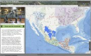
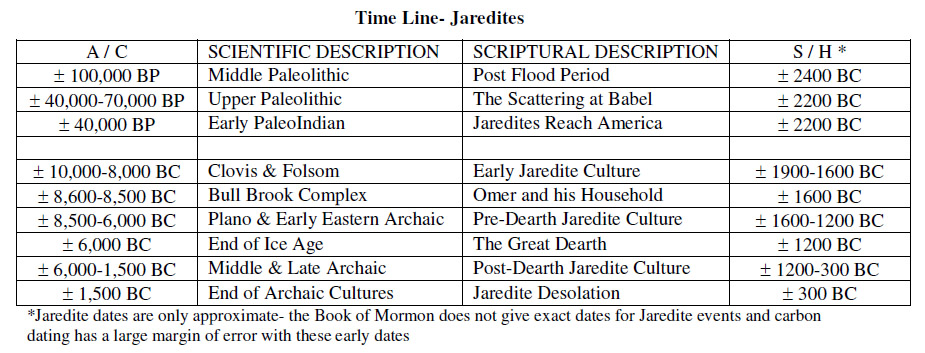


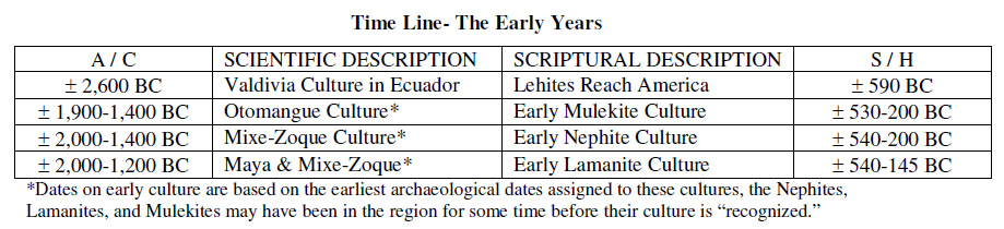


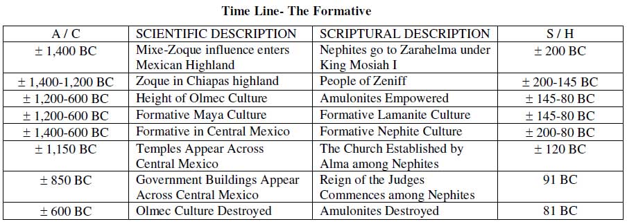


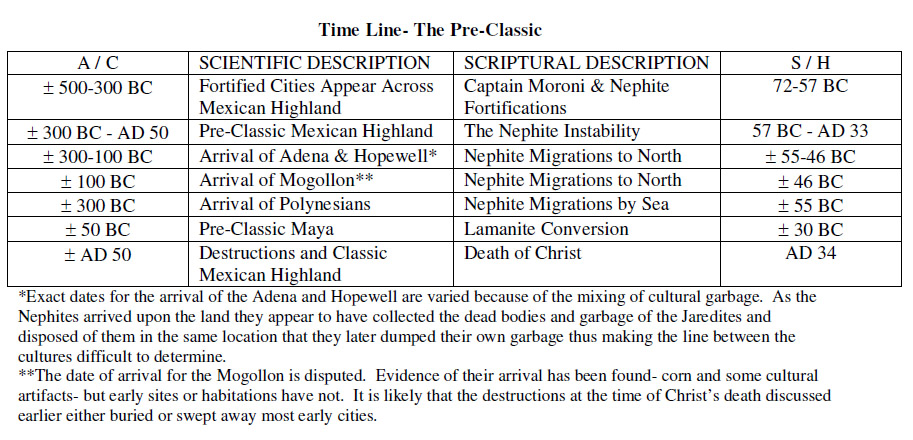

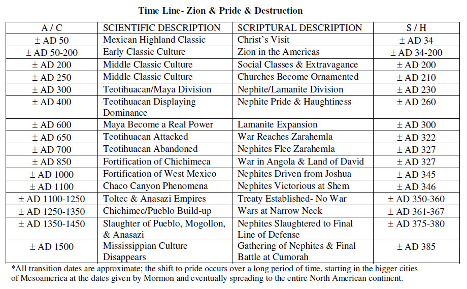


